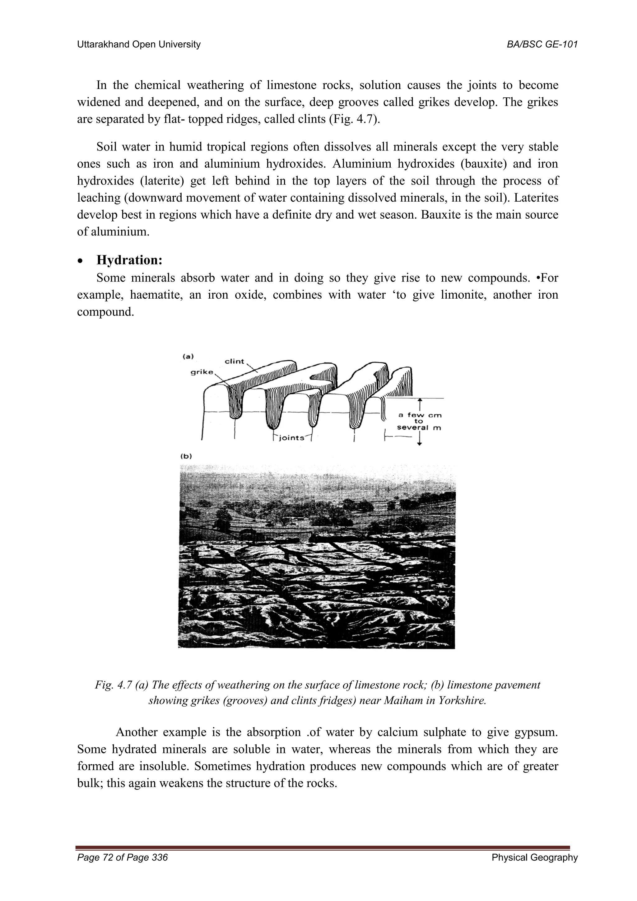
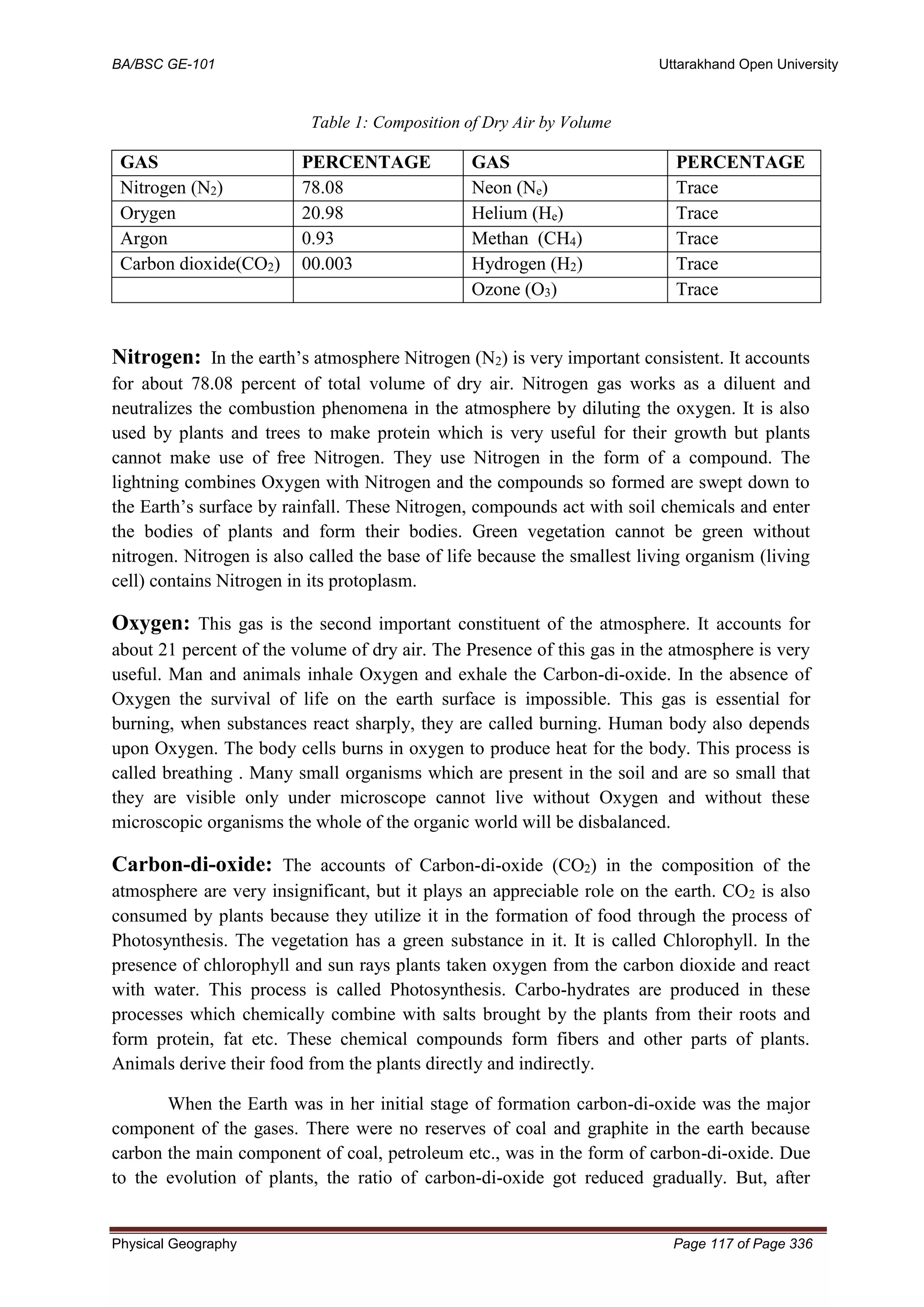
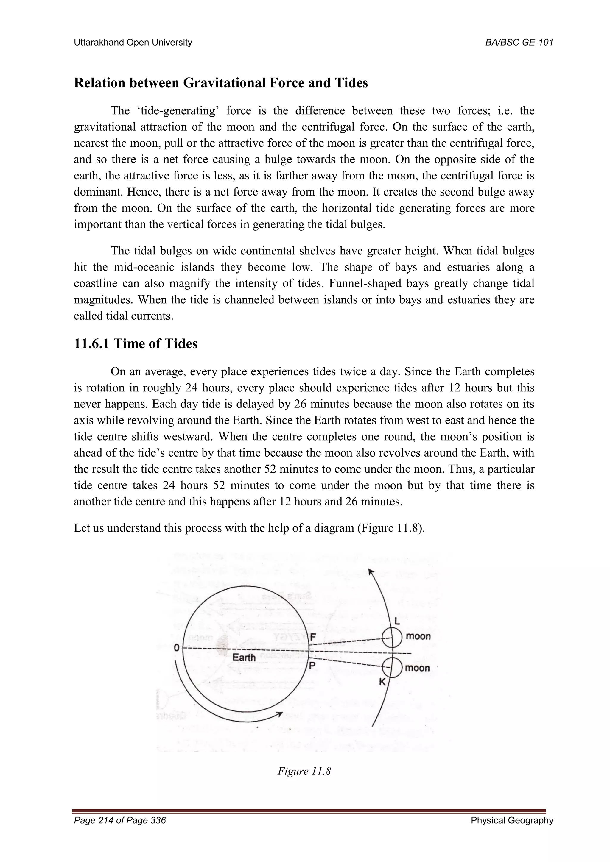
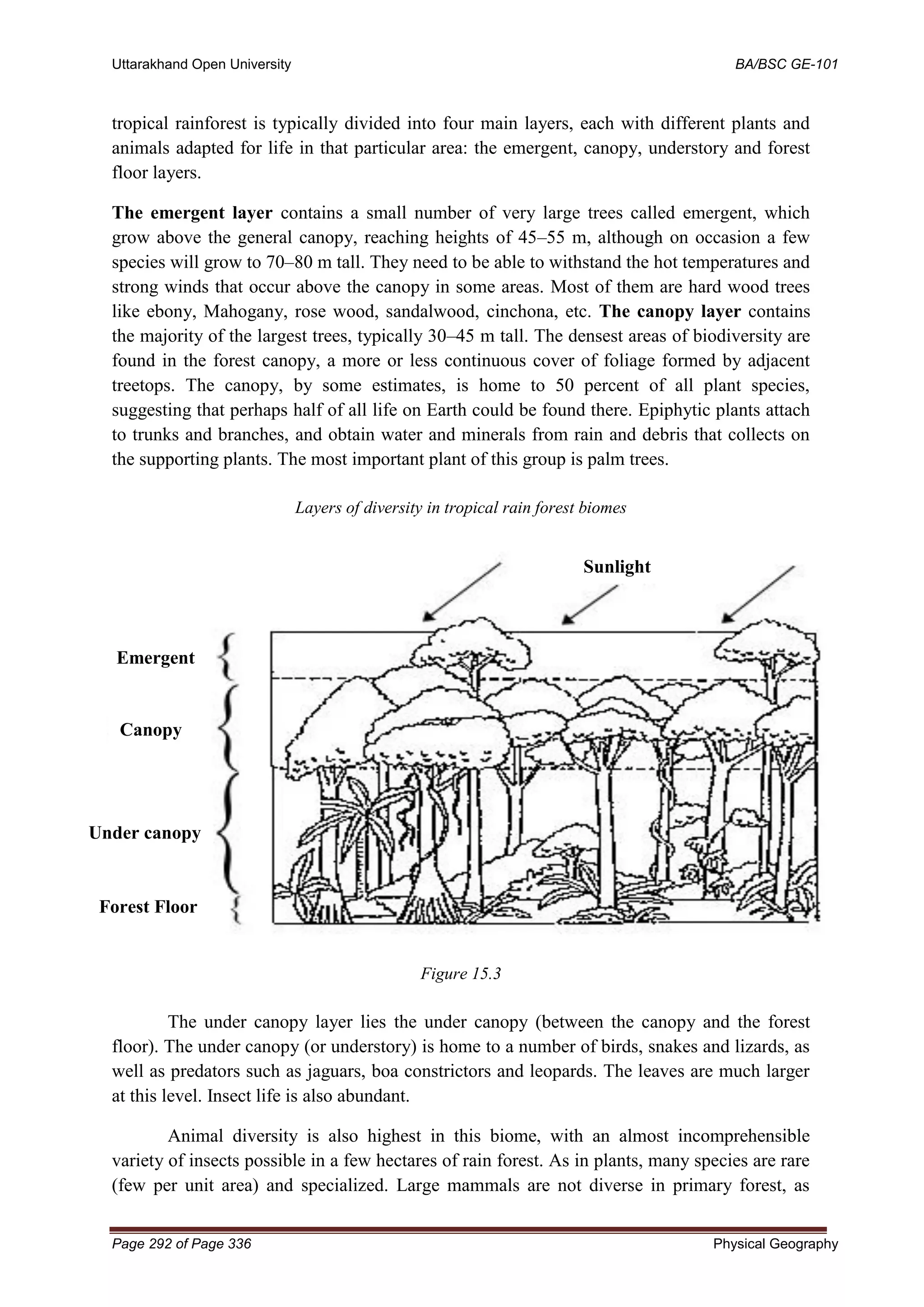
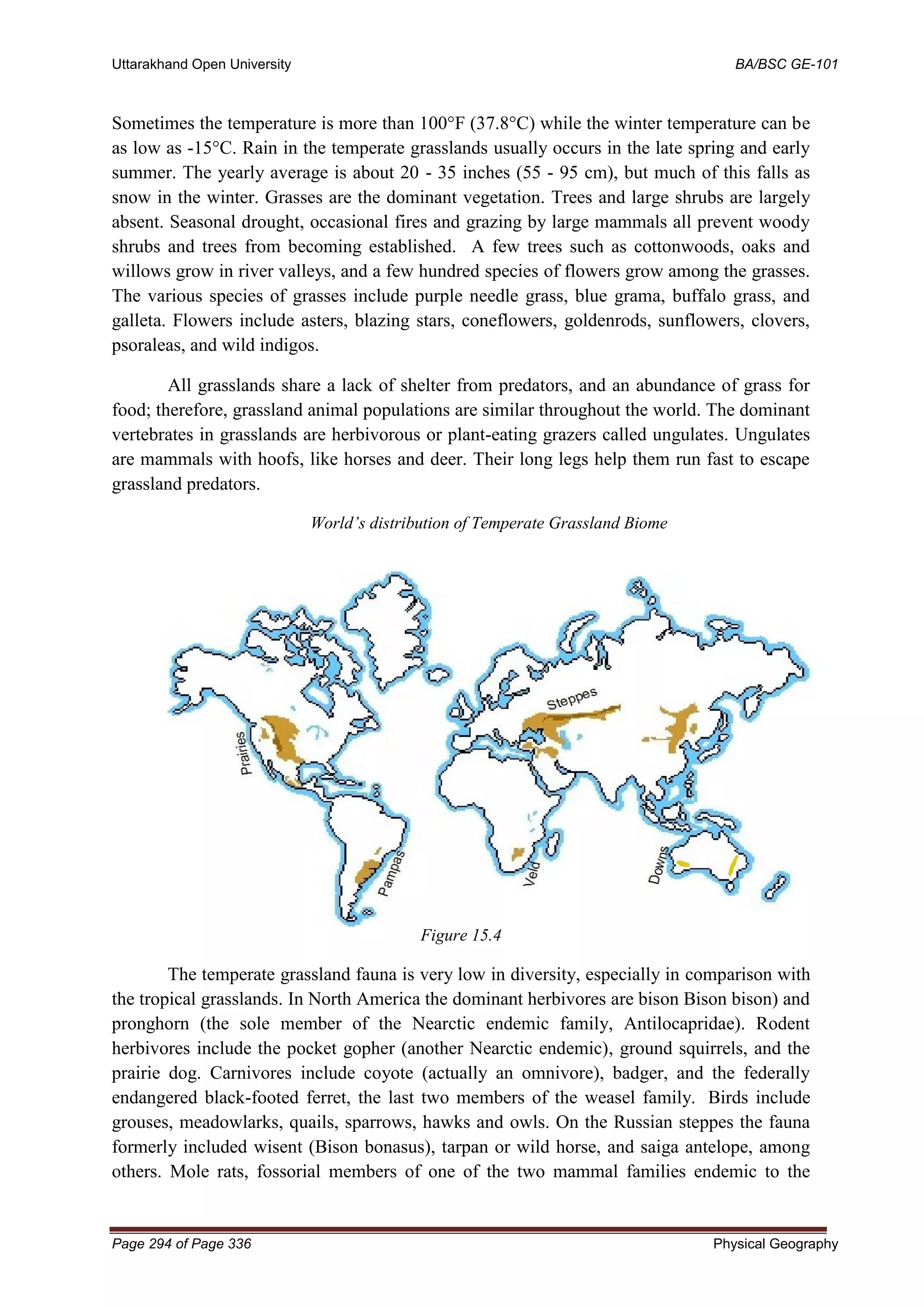
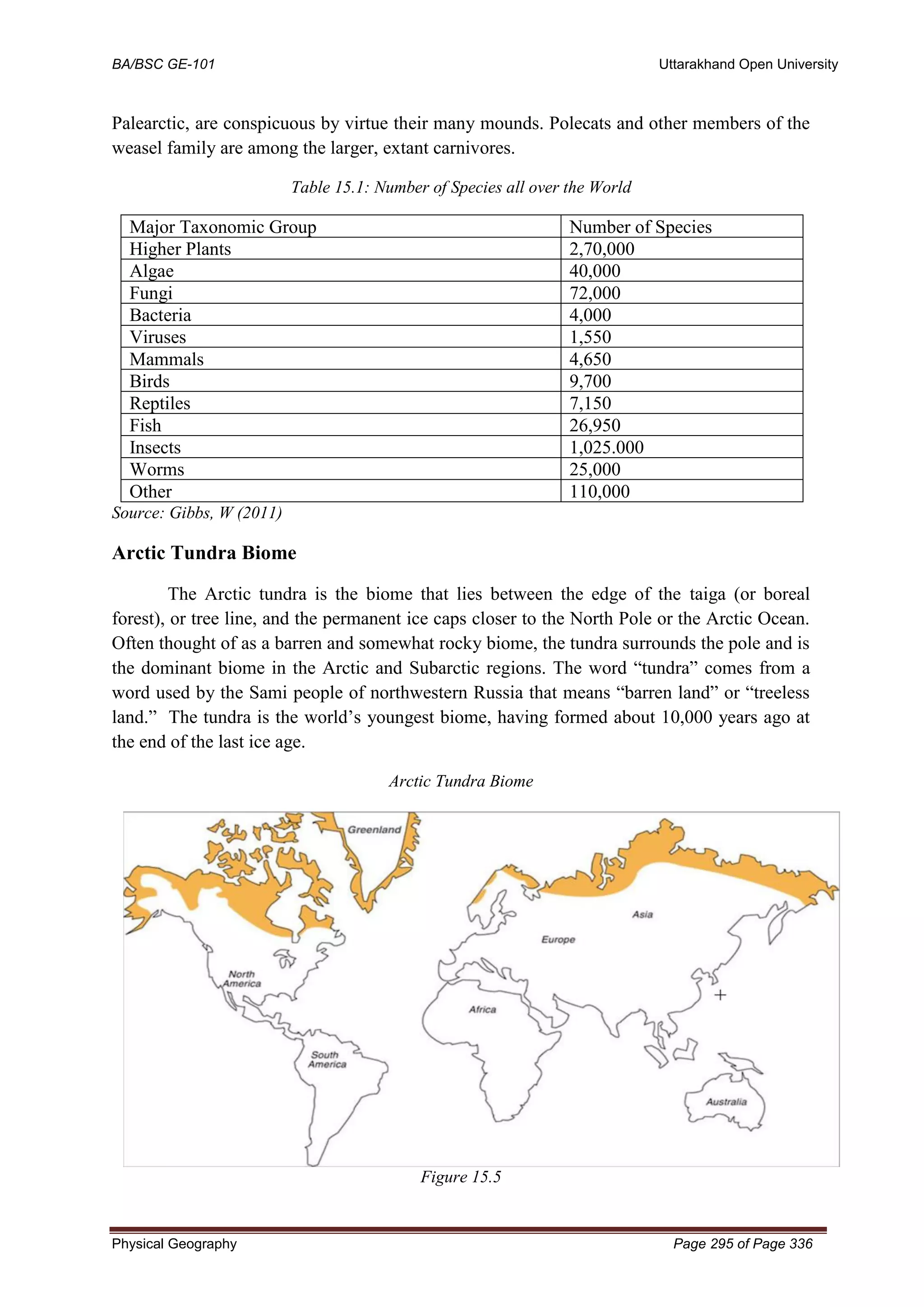
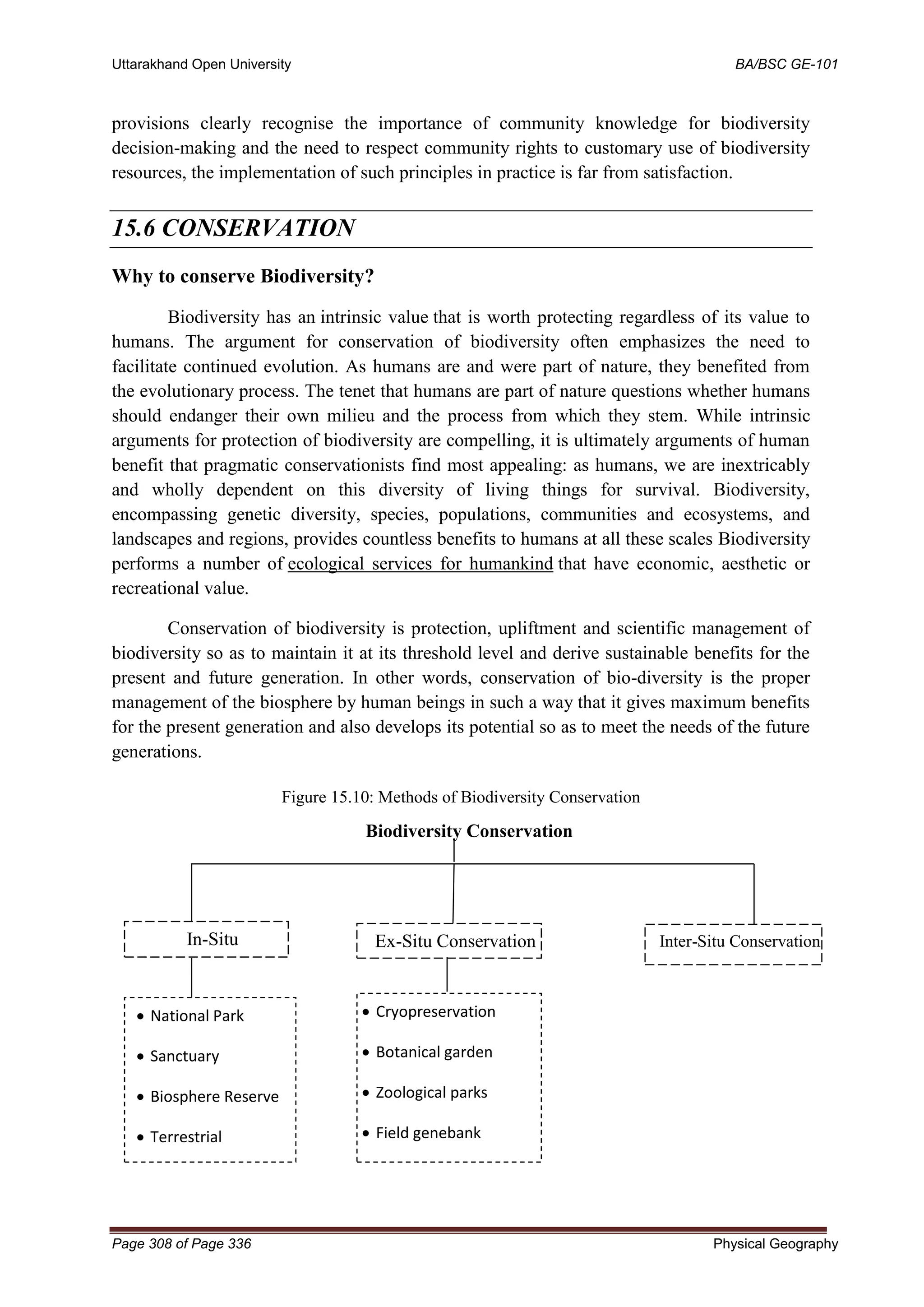
This document provides an overview of the fundamentals of physical geography as taught in a course at Uttarakhand Open University in India. It includes:
1. An introduction to physical geography as a branch of geography that studies the physical environment and natural phenomena on Earth.
2. Definitions of physical geography from various scholars that describe it as the study of the physical features of Earth and their influence on humans.
3. An outline of the scope and nature of physical geography, including its interdisciplinary nature and focus on patterns of the biosphere and interactions between the physical and human environments.


![Uttarakhand Open University BA/BSC GE-101
Page 46 of Page 336 Physical Geography
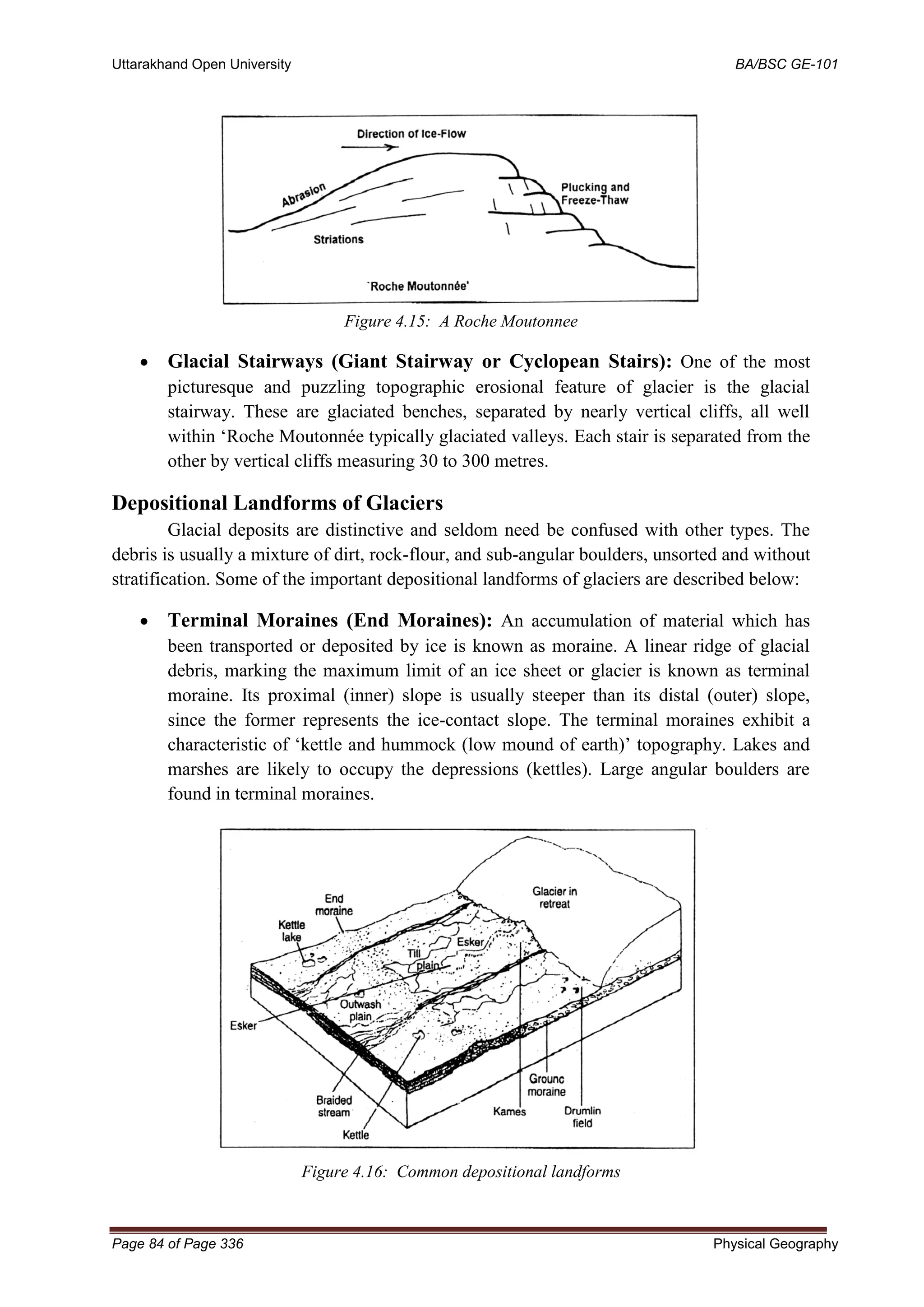
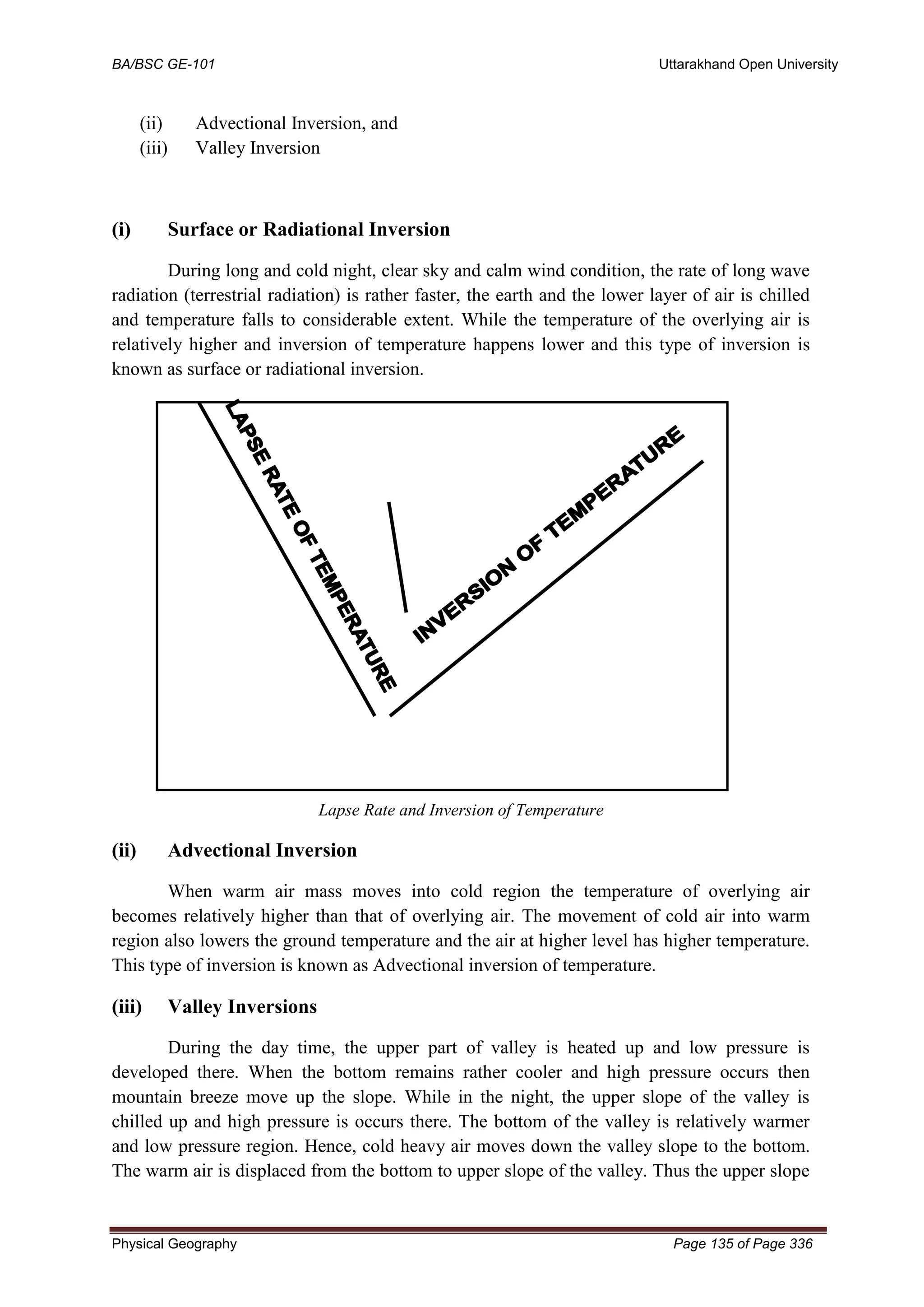
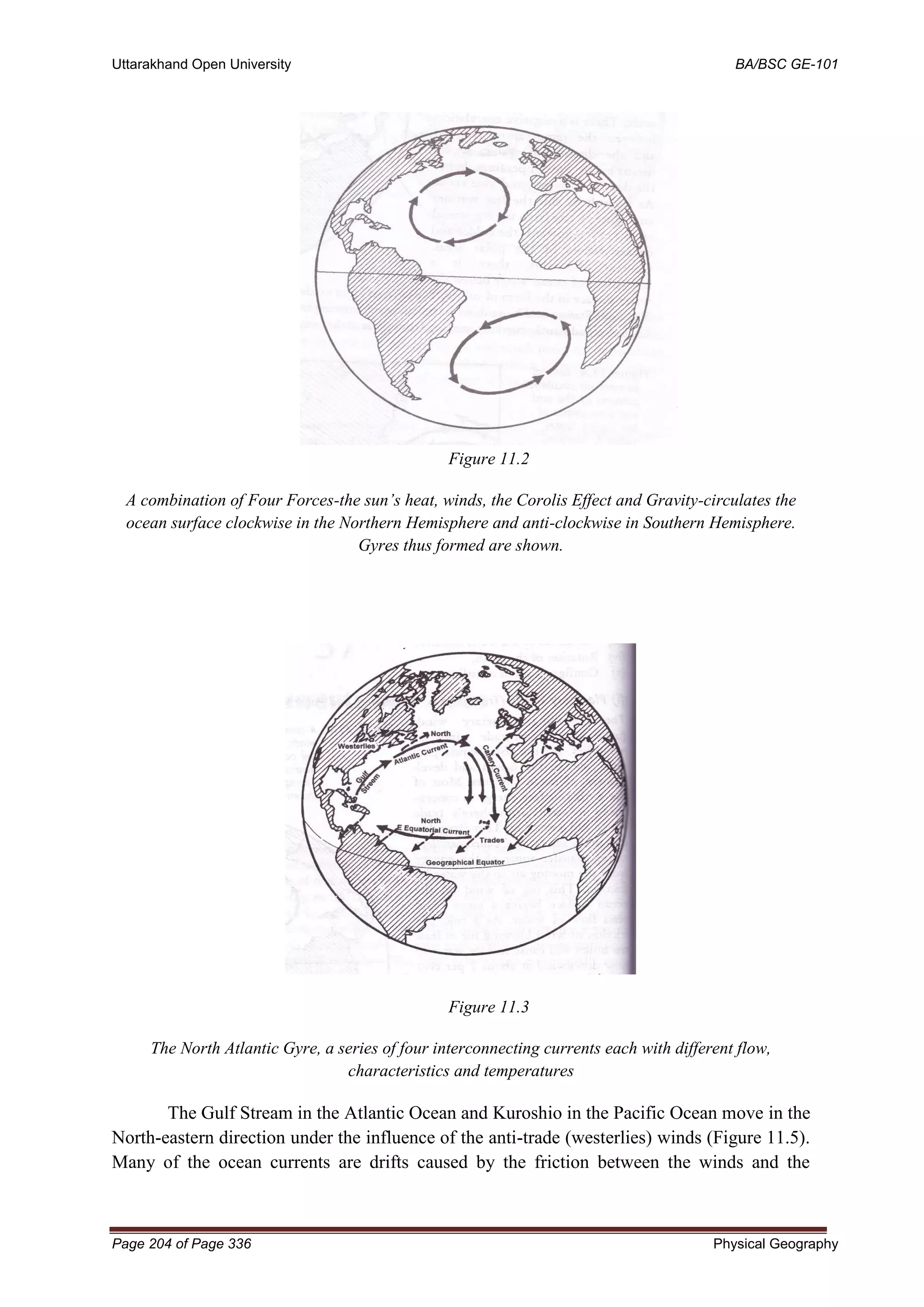
(b) The upliftment of coastal land of the continents. Such type of upliftment is called
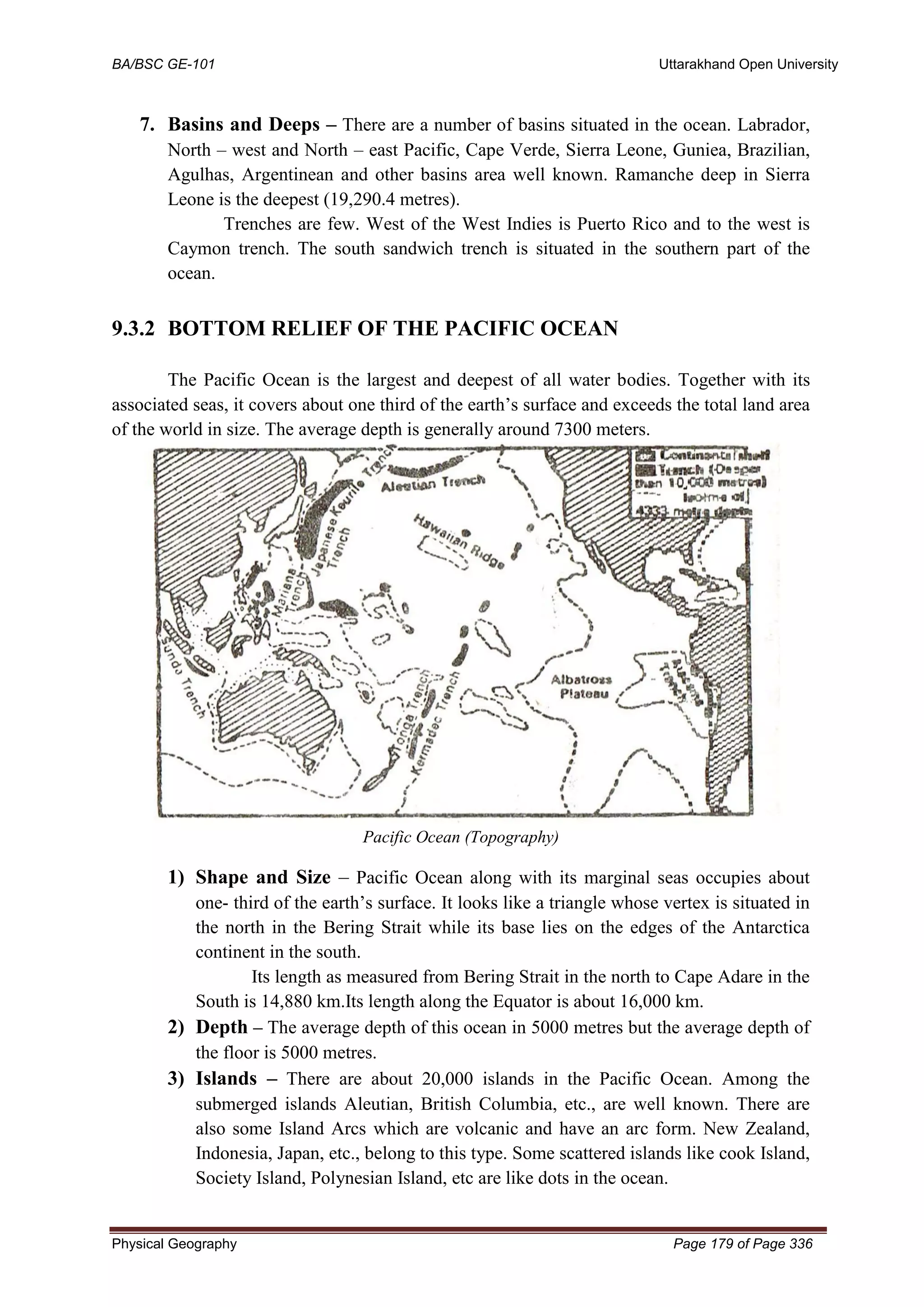
emergence.
Downward movement causes subsidence of continental masses in two ways.
(a) Subsidence of land area. Such type of downward movement is called as subsidence.
(b) Alternatively, the land area near the sea coast is moved downward or subsided below sea
level and thus submerged under sea water. Such type of downward movement is called
submergence.
3.3.2Orogenetic movements
Orogenic or the mountain-forming movements act tangentially to the earth surface, as
plate tectonics. Tensions produce fissures (this type of force acts away from a point in two
directions) and compression produces folds (because this type of force acts towards a point
from two or more directions). In the landforms so produced, the structurally identifiable units
are difficult to recognize.
Diastrophic forces have uplifted lands which have predominated forces that lowered
them.
Orogenetic movements are caused due to endogenetic forces working in horizontal manner.
Orogenetic or horizontal forces work in two ways:-
(a) In opposite directions and
(b) Towards each other.
This is called tensional force. Therefore, when this force operates in opposite directions,
tensional forces create rupture, cracks, fracture and faults in the crustal parts of the earth.
3.4 VOLCANISM: THE CONCEPT
Volcanoes are places where magma reaches the earth's surface. Volcanism is the
phenomenon of eruption of molten rock (magma) into the earth’s surface or solid-surface
planet’s or moon, where lava, pyroclastics and volcanic gases erupt through a break in the
surface called vent. It includes all phenomena’s resulting from causing magma within the crust
or mantle of the body, to rise through the crust and form volcanic rocks on the surface.
3.4.1Components of volcanoes
Magma - Molten rock beneath Earth's surface.
Parasitic Cone - A small cone-shaped volcano formed by an accumulation of volcanic
debris.
Sill - A flat piece of rock formed when magma hardens in a crack in volcano.
Vent - An opening in Earth's surface through which volcanic materials escape’s.
Flank - The side of a volcano.
Lava - Molten rocks that erupts from volcanoes and therefore solidifies as it cools.
Crater - Mouth of a volcano [ surrounds a volcanic vent].
Conduit - An underground passage through which magma travels.
Summit - Highest point, i.e. (apex).](https://image.slidesharecdn.com/ge-1011-220429111807/75/GE-101-1-pdf-46-2048.jpg)


![Uttarakhand Open University BA/BSC GE-101
Page 52 of Page 336 Physical Geography
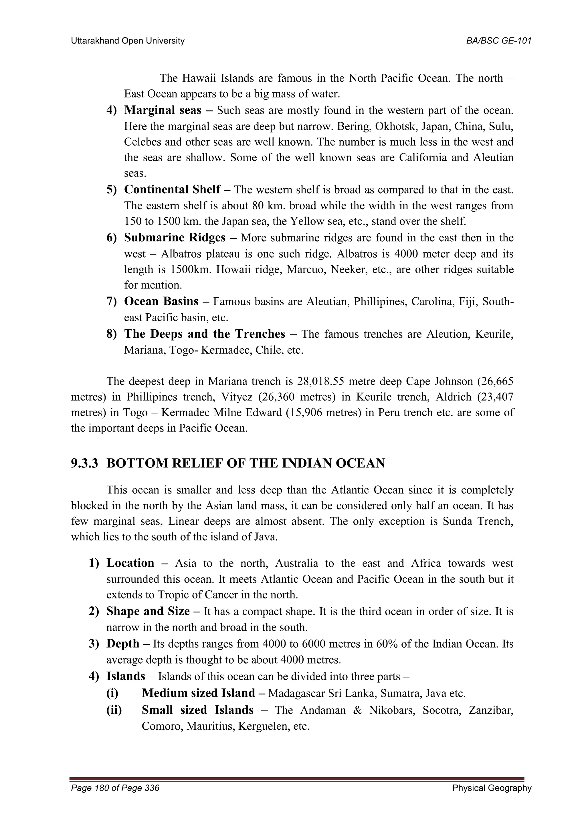
• Stromboli ‘Lighthouse of the Mediterranean’, Mt. Vesuvius, Mt. Fuji etc. are
examples.
4-Shield Type Volcanic Landforms
• The Hawaiian volcanoes are the most famous examples.
• These volcanoes are mostly made up of basalt, a type of lava that is very fluid when
erupted.
• These volcanoes are not steep.
• They become explosive if somehow water gets into the vent; otherwise, they are less
explosive.
• Example: Mauna Loa (Hawaii).
5-Fissure Type Flood Basalt Landforms [Lava Plateaus]
• Sometimes, a very thin magma escapes through cracks and fissures in the earth’s
surface and flows after intervals for a long time, spreading over a vast area, finally
producing a layered, undulating (wave like), flat surface.
• Example: Deccan traps (peninsular India), Snake Basin, U.S.A, Icelandic Shield,
Canadian Shield etc.](https://image.slidesharecdn.com/ge-1011-220429111807/75/GE-101-1-pdf-52-2048.jpg)
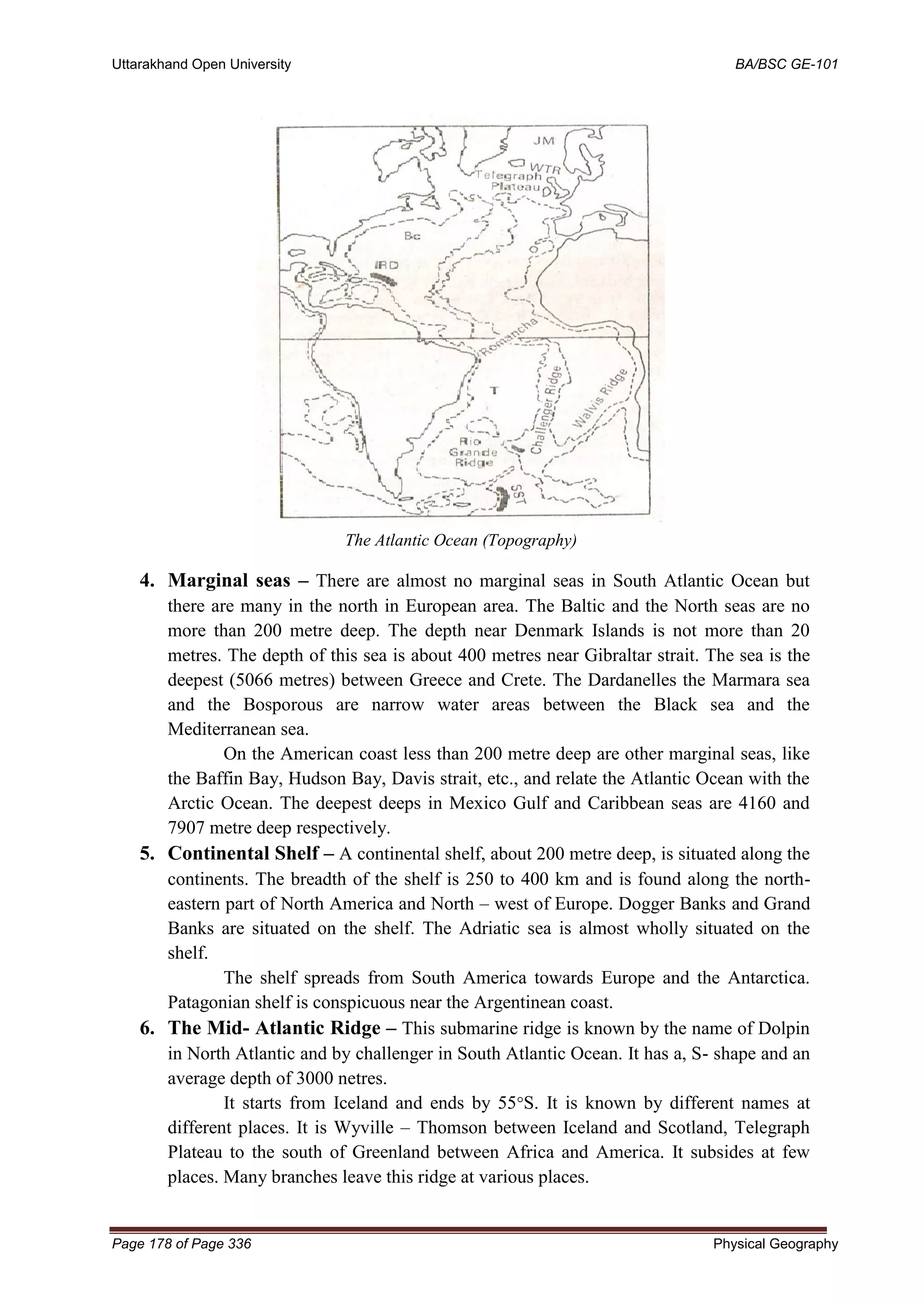
![BA/BSC GE-101 Uttarakhand Open University
Physical Geography Page 53 of Page 336
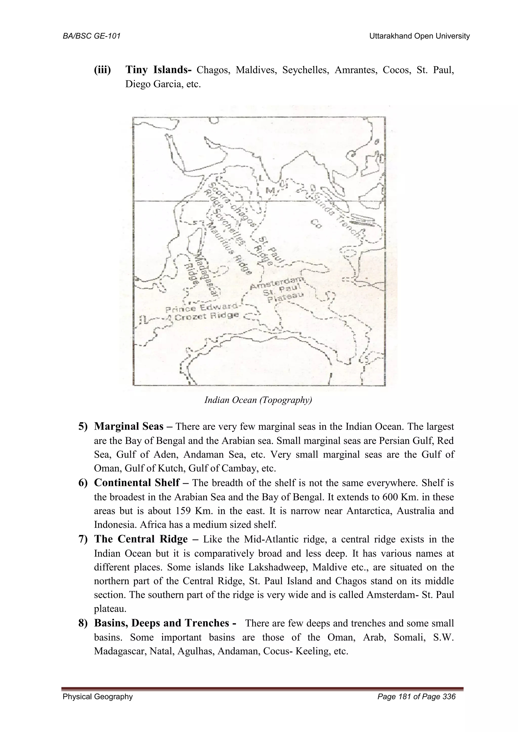
6-Caldera Lake
• After the eruption of magma has ceased, the crater frequently turns into a lake at a
later time. This lake is called a ‘caldera’. Examples: Lonar in Maharashtra and
Krakatao in Indonesia.
7-Cinder cone
• A cinder cone is a steep conical hill of loose pyroclastic fragments, such as volcanic
clinkers, cinders, volcanic ash, or scoria that has been built around a volcanic vent.
Intrusive Volcanic Landforms
• Intrusive landforms are formed when magma cools within the crust [Plutonic rocks
(intrusive igneous rock)].
• The intrusive activity of volcanoes gives rise to various forms.](https://image.slidesharecdn.com/ge-1011-220429111807/75/GE-101-1-pdf-53-2048.jpg)


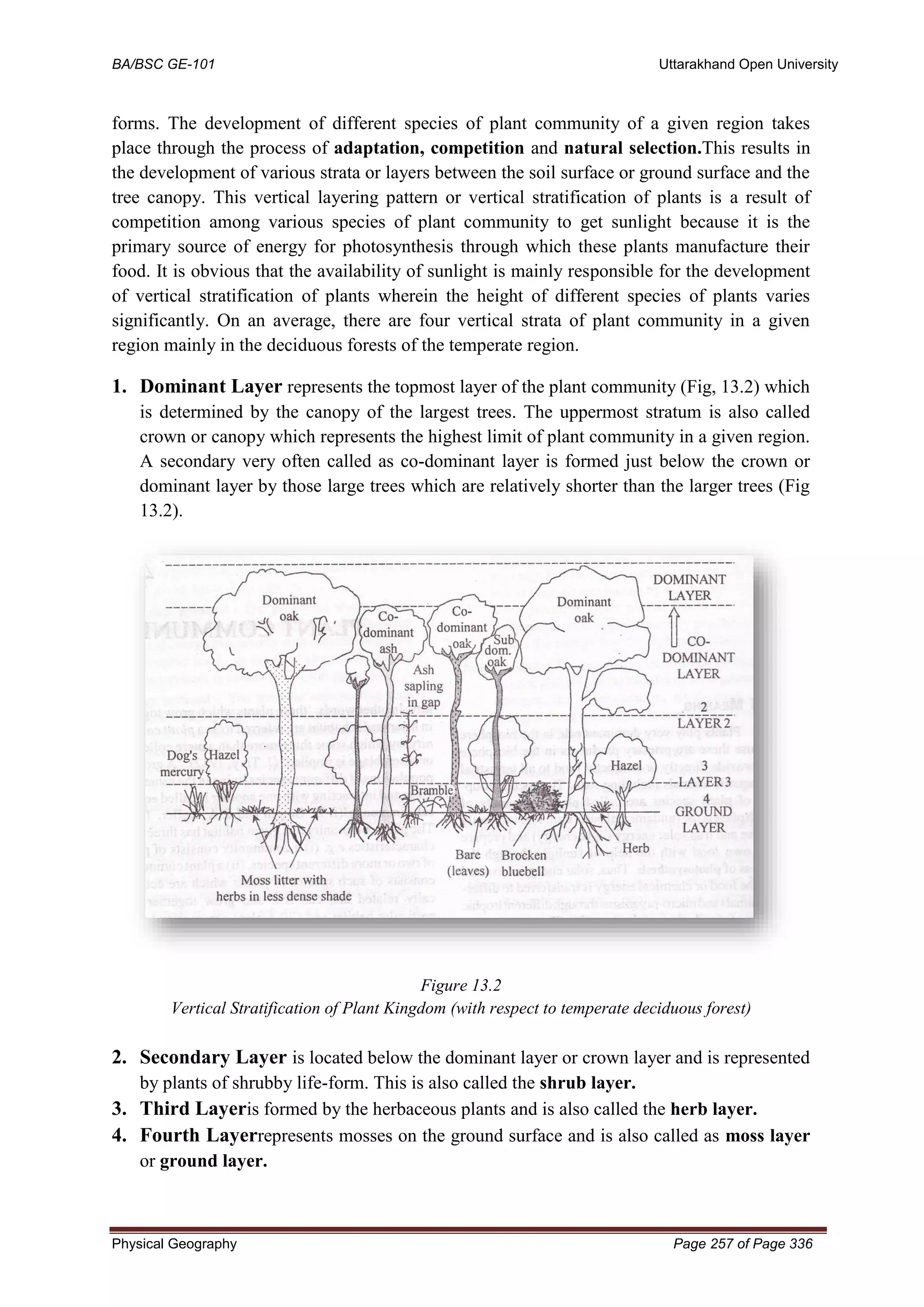
![BA/BSC GE-101 Uttarakhand Open University
Physical Geography Page 255 of Page 336
particular species well, but its presence or absence at any particular location depends to some
extent on chance, on its dispersal abilities and its efficiency as a coloniser.
Freshwater habitats include rivers, streams, lakes, ponds, marshes and bogs. Although
some organisms are found across most of these habitats, the majority have more specific
requirements. The water velocity, its temperature and oxygen saturation are important
factors, but in river systems, there are fast and slow sections,
pools, bayous and backwaters which provide a range of habitats. Similarly, aquatic plants can
be floating, semi-submerged, submerged or grow in permanently or temporarily saturated
soils besides bodies of water. Marginal plants provide important habitat for both
invertebrates and vertebrates, and submerged plants provide oxygenation of the water, absorb
nutrients and play a part in the reduction of pollution.
Marine habitats include brackish water, estuaries, bays, the open sea, the intertidal
zone, the sea bed, reefs and deep water zones.[11]
Further variations include rock pools, sand
banks, mudflats, brackish lagoons, sandy and pebbly beaches, and sea-grass beds, all
supporting their own flora and fauna. The benthic zone or seabed provides a home for both
static organisms, anchored to the substrate, and for a large range of organisms crawling on or
burrowing into the surface. Some creatures float among the waves on the surface of the
water, or raft on floating debris, others swim at a range of depths, including organisms in
the demersal zone close to the seabed, and myriads of organisms drift with the currents and
form the plankton.
A desert is not the kind of habitat that favours the presence of amphibians, with their
requirement for water to keep their skins moist and for the development of their young.
Nevertheless, some frogs live in deserts, creating moist habitats underground and hibernating
while conditions are adverse. Couch's spadefoot toad (Scaphiopuscouchii) emerges from its
burrow when a downpour occurs and lays its eggs in the transient pools that form; the
tadpoles develop with great rapidity, sometimes in as little as nine days,
undergo metamorphosis, and feed voraciously before digging a burrow of their own.
Other organisms cope with the drying up of their aqueous habitat in other
ways. Vernal pools are ephemeral ponds that form in the rainy season and dry up afterwards.
They have their specially-adapted characteristic flora, mainly consisting of annuals, the seeds
of which survive the drought, but also some uniquely adapted perennials. Animals adapted to
these extreme habitats also exist; fairy shrimps can lay "winter eggs" which are resistant
to desiccation, sometimes being blown about with the dust, ending up in new depressions in
the ground. These can survive in a dormant state for as long as fifteen
years. Some killifish behave in a similar way; their eggs hatch and the juvenile fish grow
with great rapidity when the conditions are right, but the whole population of fish may end
up as eggs in diapause in the dried up mud that was once a pond.
Many animals and plants have taken up residence in urban environments. They tend
to be adaptable generalists and use the town's features to make their homes. Rat and mice
have followed man around the globe, pigeons, peregrines, sparrows, swallows and house
martins use the buildings for nesting, bats use roof space for roosting, foxes visit the garbage](https://image.slidesharecdn.com/ge-1011-220429111807/75/GE-101-1-pdf-255-2048.jpg)


![BA/BSC GE-101 Uttarakhand Open University
Physical Geography Page 317 of Page 336
Q. 9. Among the ecosystem services are control of floods and soil erosion. How is this
achieved by the biotic components of the ecosystem?
Ans. Control of floods and soil erosion are done by preserving the forests. There must be a
balance between the plants and animals to maintain the biodiversity.
15.12 REFERENCES
1. Heywood VH, ed. 1995. Global Biodiversity Assessment. Cambridge (UK):
Cambridge University Press.
2. Heywood, V.H., and R.T. Watson, Eds., 1995: Global biodiversity assessment.
Cambridge University Press, Cambridge, 1140 pp. [Global; Biodiversity]
3. Levin, S. A. 2001. Encyclopedia of Biodiversity. Vol. 1 – 5. Academic Press.
4. Mayr, Ernst (1963). Animal Species and Evolution. Cambridge: Belknap Press of
Harvard University Press.797pp.
5. R.H. Whittaker. 1972. Evolution and measurement of species diversity. Taxon,
21:213_251
6. M. Jnr. Hunter. 2002. Fundamentals of Conservation Biology. Second Edition.
Blackwell
Science, Massachusetts, U.S.A.
7. L.A. Nielsen R.L. Knight Meffe, G.K. and D.A. Schenborn. 2002. Ecosystem
management: adaptive, community-based conservation. Island Press, Washington,
D.C.,
8. Borang, A. 2004. Birds of Arunachal Pradesh in North East India – the check list and
distribution in protected areas (unpublished). Forest Zoology Division, SFRI,
Itanagar.
9. Tripathi, R S and Barik, S K (2003) National Biodiversity Strategy and Action Plan
Report for Northeast India. Ministry of Environment and Forests, New Delhi.
10. Mao, A. A., Singh, K. P. and Hajra, P. K. 2001. Rhododendron. In: Floristic diversity
and Conservation Strategies in India. Vol. IV (eds. K. P. Singh and N. P. Singh), pp.
2167-2202. Botanical Survey of India, Kolkata.
11. Williams, P. H. and Humphries, C. J. 1996. Comparing character diversity among
biotas. Biodiversity. A biology of number and differences. (ed. Gatson, K. J.).
Blackwell Science, Oxford U.K., pp. 54-76.
12. Alkemade, R., M. van Oorschot, L. Miles, C. Nellemann, M. Bakkenes, and B. ten
Brink. 2009. GLOBIO3: A Framework to Investigate Options for Reducing Global
Terrestrial Biodiversity Loss. Ecosystems 12:374-390.
13. Peter M.Vitoasek, Paul R.Ehrlich.Anne H.Ehrlich et al., "Human Appropriation of
the Products of Photosynthesis," BioScience, Vol. 36, No. 6 (1986), pp. 368-373.
14. Millennium Ecosystem Assessment, 2005. Ecosystems and Human Well-being:
Biodiversity Synthesis. World Resources Institute, Washington, DC. Copyright ©
2005 World Resources Institute](https://image.slidesharecdn.com/ge-1011-220429111807/75/GE-101-1-pdf-317-2048.jpg)


![GEOGRAPHY-WPS-Office [Autosav.....ed].pptx](https://cdn.slidesharecdn.com/ss_thumbnails/geography-wps-officeautosaved-250309073130-b5d8c98e-thumbnail.jpg?width=640&height=640&fit=bounds)