Draw Contours Worksheet
•Download as PPT, PDF•
6 likes•4,953 views
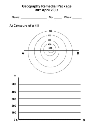
This document contains contour maps of six different landforms: 1) A hill with concentric contour lines showing increasing elevation from the base. 2) A plateau with evenly spaced horizontal contour lines showing a flat top region. 3) A ridge with contour lines spaced farther apart at the top and bottom showing a narrow elongated elevation. 4) A floodplain with contour lines bending inward near the center showing lower elevation around a river or stream. 5) A valley with contour lines bending outward near the center showing higher elevation on both sides of a low point. 6) Different slope profiles including uniform, stepped, concave, and convex shapes.
Report
Share
Report
Share

Recommended
Evolution of Geomorphic theory- Geomorphology Chapter
1. Early theories of landscape evolution included catastrophism and uniformitarianism. Davis later proposed the cycle of erosion, which described fixed stages of landscape development over time.
2. Penck built on Davis's work by proposing ongoing tectonism could influence landscape evolution. He described waxing, uniform, and waning stages of development driven by changing uplift and erosion rates.
3. King further developed these ideas, arguing landscapes evolve through parallel slope retreat and may culminate in a pediment under certain conditions. Modern geomorphology views landscapes as intricate systems influenced by various dynamic factors and processes.
Remote Sensing Imagery & Artificial Intelligence
The following presentation was delivered by Robert Morrison, Principal Consultant at Esri Ireland, at the 2019 NICS ICT Conference in October 2019.
The presentation focuses on taking a geographic approach to machine learning to help you "see what other's can't".
Imagery and remotely sensed data is a valuable resource for many organisations who have made substantial investment obtaining the data. The field of Machine Learning is both broad and deep and is constantly evolving. Using ArcGIS and Machine Learning allows organisations to derive valuable new content.
ArcGIS is an open, interoperable platform that allows for the integration of complementary methods and techniques that empower ArcGIS users to solve complex, real-world problems in a fundamentally spatial way.
Learn how by combining powerful built-in Image analysis tools with any machine learning package users can benefit from the spatial validation, geo-enrichment and visualisation. See how this Machine Learning is being applied in real world use-cases from marine farming and crime analysis to agriculture and sustainability.
Remote sensing-presentaion
This document discusses satellite remote sensing. It provides details on different types of remote sensing satellites including Landsat, MODIS, SPOT, IRS series, and IKONOS. It also describes various sensors used in remote sensing such as MSS, TM, HRV, LISS, PAN, and WiFS. The document discusses the basic principles, components, and applications of remote sensing from satellites for land resources survey, environmental monitoring, and other purposes.
GEOGRAPHIC SKILLS: CHOROPLETH MAPS
GEOGRAPHIC SKILLS: CHOROPLETH MAPS.
A choropleth map is a thematic map in which areas are shaded or patterned in proportion to the measurement of the statistical variable being displayed on the map, such as population density or per-capita income.
AP Human Geography: Unit 2 Powerpoint: Population and Migration (Sample)
Here is a sample from my Advanced Placement Human Geography Unit 2 Powerpoint I will be using to teach my classes this year. It is on Population and Migration. You can find the full version at http://tinyurl.com/eilandunit2.
Dark Ages Geography
This document provides information about the Dark Ages in Europe and the influence of geography on medieval society. It begins with questions for students to answer about the Dark Ages and European geography. It then defines the Dark Ages as the period from 476-1000 CE after the fall of Rome when Europe lacked leadership. Historians call it "Dark" due to lack of information and little cultural advancement. The document describes the different climates and crops of Northern and Southern Europe and how abundant resources like forests and farmland allowed small self-sufficient kingdoms to form. Geography shaped medieval society by providing good conditions for farming and production across Europe.
GIS Modeling
This document provides an overview of GIS modeling using ModelBuilder in ArcGIS. It defines static and dynamic modeling and explains why modeling is useful for reproducibility, workflow efficiency, and handling tasks that would be impractical for a user to perform manually. Modeling allows for repeat testing of hypotheses with different data. The document outlines how to create models in ModelBuilder using a drag-and-drop interface to link together geoprocessing tools into a workflow and provides examples of models used in practice. It notes that models can be exported as scripts for additional functionality like cursor-based analysis and internet access.
History of cartography
This document provides an overview of cartography. It begins with definitions of cartography and discusses the importance and history of maps. The history section outlines some of the earliest maps from ancient civilizations like Babylonia, Egypt, and Greece. It also describes important contributions from figures like Ptolemy, including his world map and map projections. The document emphasizes that cartography has progressed from early conceptual maps to more accurate representations incorporating scientific principles.
Chapter 5: Remote sensing
Analysis of remote sensing imagery involves identifying targets through their tone, shape, size, pattern, texture, and relationships to other objects. Targets may be environmental or artificial features appearing as points, lines, or areas. Interpretation relies on how radiation is reflected or emitted from targets and recorded by sensors to form images. The key to interpretation is recognizing targets based on these visual elements.
Map Design and Symbology in GIS Environment
This document discusses key principles of map design including selection of colors, symbols, labeling, and overall layout. It emphasizes that while there are scientific rules of map design, there is also an artistic element. The document outlines topics to be covered such as map scale and generalization, symbolization, choropleth mapping, use of color, and labeling. It provides guidelines for map elements like titles, legends, and orientation indicators. It also discusses classification schemes, issues with choropleth maps, effective use of color, and best practices for labeling and typography. Ethical practices of map design to avoid deception are highlighted.
REMOTE SENSING IN GROUNDWATER.pptx
Introduction
Water resources of India at a glance
Hydrogeological cycle
Exploration of groundwater
Groundwater potential zone
Indicators
Sensors
Rules for selection of imagery
Conclusion
Reference
Geographical information system in transportation planning
This document discusses the use of geographical information systems (GIS) in transportation planning. It begins by introducing GIS and how it can help with transportation systems. GIS is then categorized into three areas: data representation, analysis and modeling, and applications. Examples of GIS applications in transportation include highway management, accident analysis, route planning, and traffic modeling. The document also outlines some challenges of GIS in transportation and concludes that GIS is a key tool for analysis and decision making in public and private transportation planning.
QUERY AND NETWORK ANALYSIS IN GIS
This document discusses geospatial techniques for query and network analysis in GIS. It introduces key concepts like attribute queries, spatial queries, and network analysis. Network analysis allows solving problems like finding optimal routes and closest facilities. Common network analysis techniques discussed include shortest path, closest facility, and OD cost matrix analysis. Applications mentioned are routing, resource allocation, and traveling salesman problems. The document concludes that query and network analysis techniques are useful for obtaining detailed spatial and attribute information in urban planning.
Remote Sensing: Overlay Analysis
An overlay operation is much more than a simple merging of linework; all the attributes of the features taking part in the overlay are carried through. In general, there are two methods for performing overlay analysis—feature overlay (overlaying points, lines, or polygons) and raster overlay. Some types of overlay analysis lend themselves to one or the other of these methods. Overlay analysis to find locations meeting certain criteria is often best done using raster overlay (although you can do it with feature data). Of course, this also depends on whether your data is already stored as features or raster. It may be worthwhile to convert the data from one format to the other to perform the analysis.
Weighted Overlay
Overlays several raster files using a common measurement scale and weights each according to its importance.
The weighted overlay table allows the calculation of a multiple criteria analysis between several raster files.
Raster- The raster of the criteria being weighted.
Influence- The influence of the raster compared to the other criteria as a percentage of 100.
Field- The field of the criteria raster to use for weighting.
Remap- The scaled weights for the criterion.
In addition to numerical values for the scaled weights in Remap, the following options are available:
Restricted- Assigns the restricted value (the minimum value of the evaluation scale set, minus one) to cells in the output, regardless of whether other input raster files have a different scale value set for that cell.
No data - Assigns No Data to cells in the output, regardless of whether other input raster files have a different scale value set for that cell.
THIS PRESENTATION IS TO HELP YOU PERFORM THE TASK STEP BY STEP.
Aerial photographs and their interpretation
Aerial photographs provide valuable information about the coastal and terrestrial environment when interpreted correctly. Vertical aerial photographs can be used to update existing maps and create new maps. Simple instruments can be used to correct horizontal distortion in aerial photographs and transfer information to line maps. More advanced photogrammetric equipment is required to correct for height displacement. Stereoscopic analysis of overlapping aerial photographs allows for three-dimensional interpretation of terrain and features.
Watershed delineation
Digital elevation models (DEMs) can be used to delineate watersheds through a multi-step hydrologic modeling process. The DEM is first used to determine flow direction from each cell based on steepest downhill slope. Flow accumulation is then calculated to identify streams above a threshold. Stream networks and outlets are identified and used to delineate watershed polygons for each outlet. Vector conversion and post-processing steps such as dissolving spurious polygons and merging watersheds produce the final watershed delineation.
Band Combination of Landsat 8 Earth-observing Satellite Images
This document discusses Landsat 8, an Earth-observing satellite launched by NASA in 2013. It provides details on Landsat 8 such as its mission to continuously archive global images of Earth since the 1970s, how it collects about 400 scenes per day, and its various spectral bands that can be used alone or combined for different analyses. Band combination examples are shown for Landsat 8 images before and after processing of Inle Lake to demonstrate the use of natural color, color infrared, and different false color composites.
Topography, landform and geomorphology-Geomorhology Chapter
This document provides definitions and information about topography, landforms, and geomorphology. It defines topography as the elevation and relief of the Earth's surface, landforms as the topographic features, and geomorphology as the study of earth surface processes and landforms. It discusses various landforms including those formed by tectonic, depositional, weathering, erosion, and mass wasting processes. It also covers related topics like uniformitarianism, the genetic classification of landforms, crustal orders of relief, and important deformation processes like folding and faulting.
Remote Sensing: Resolution Merge
With increasing use of remote sensing, the need for crispier, accurate and enhanced precision has deemed to the improvement in the spectral and spatial resolution of remotely sensed imagery. For most of the systems, panchromatic images typically have higher resolution, while multispectral images offer information in several spectral channels. Resolution merge (also called pan-sharpening) allows us to combine advantages of both kinds of images by merging them into one.
The resolution merge or pan sharpening is the technique used to obtain high resolution multi-spectral images. The color information is collected from the coarse resolution satellite data and the intensity from the high resolution satellite data.
The main constraint is to preserve the spectral information for aspects like land use. Saving theimage from distortion of the spectral characteristics is important in the merged dataset.
The most common techniques for spatial enhancement of low-resolution imagery combining high and low resolution data can be used are: Intensity-Hue-Saturation, Principal Component, Multiplicative and Brovey Transform.
THIS PRESENTATION IS TO HELP YOU PERFORM THE TASK STEP BY STEP.
Bhuvan
Bhuvan is a free web-based geospatial visualization system developed by ISRO to view satellite imagery of India. It allows 2D and 3D exploration of the earth's surface with high resolution imagery. Users can access maps, data, and services like disaster management. Bhuvan also provides an open data archive with satellite datasets for download to support research. It is a versatile tool for education, science, and administration.
Landuse landcover mapping
Land cover refers to the feature present and land use refers to the human activity associated with a plot of land
Remote Sensing and GIS in Land Use / Land Cover Mapping
This document discusses using remote sensing and GIS for land use/land cover mapping. It describes analyzing agricultural versus urban land to ensure development doesn't degrade farmland. Land cover refers to ground surface characteristics like vegetation or bare soil, while land use refers to how land is used, such as agriculture or recreation. The document outlines classification systems and criteria for remote sensing-based land use/land cover mapping. It also discusses digital classification techniques, global and national land use datasets, and applications of remote sensing for natural resource management and change detection analysis.
GEOGRAPHICAL INFORMATION SYSTEM (GIS)
This document provides an overview of geographical information systems (GIS). It discusses that GIS is a computer system for capturing, storing, analyzing and displaying spatial data. The document outlines the history of GIS, its components including hardware, software and data, common data structures like raster and vector, and procedures for spatial analysis and querying. It also discusses applications of GIS in areas like public health for disease mapping and planning interventions. Remote sensing, global positioning systems and their uses are summarized. The document concludes with a SWOT analysis of GIS.
Core-Periphery Model of John Friedmann
This slide discusses about the core-periphery model given by John Friedmann. This model is basically a model of regional Development. You will able to learn about the core-periphery model very easily by this slide.
Mineral systems: key to exploration targeting
The document discusses mineral systems as complex dynamic systems exhibiting self-organized critical behavior. It identifies four critical elements of mineral systems: whole lithosphere architecture, transient geodynamic triggers, fertility, and preservation of the primary depositional zone. It emphasizes that the scale of decision-making in mineral exploration must match the scale of the relevant geological processes, such as considering lithosphere-scale architecture when making camp-scale exploration decisions.
Curve number_gis
This document summarizes a study that used GIS and the Natural Resources Conservation Service Curve Number (NRCS-CN) method to estimate runoff in the Kardeh watershed in Iran. The study aimed to determine runoff depth using the NRCS-CN method with GIS and examine the effect of slope on runoff generation. Land use, soil, and slope maps were generated in GIS and used to assign CN values. Estimated runoff depths were compared to observed data and a positive correlation was found, though some estimated values differed from observed by over 50%. The results supported using the NRCS-CN method with GIS to estimate runoff in ungauged watersheds in the region.
GEOGRAPHY IGCSE: POPULATION DENSITY AND DISTRIBUTION
This document discusses factors that influence population density and distribution around the world. It provides examples of areas with high and low population densities, such as Singapore being very densely populated due to its small land area, while countries in the Sahel region of Africa have sparse populations partly due to large desert areas. Environmental factors like climate, land type and resources can attract or discourage settlement, affecting population distribution patterns locally and globally.
Landslide aw
The document summarizes a presentation on landslides given by Azmeraw W. It discusses:
1) Definitions of landslides and classifications based on material, movement, rate, water/ice content, and other factors. Common types include falls, topples, slides, spreads, and flows.
2) Factors that influence landslides like slope geometry, material, groundwater, and external triggers such as rainfall, earthquakes, and human activities.
3) Effects of landslides including damage to infrastructure and losses of life, property, and economic activity.
4) Methods for creating landslide inventories, susceptibility maps, hazard maps, and risk maps to assess landslide dangers and
Main news related to the CCS TSI 2023 (2023/1695)
An English 🇬🇧 translation of a presentation to the speech I gave about the main changes brought by CCS TSI 2023 at the biggest Czech conference on Communications and signalling systems on Railways, which was held in Clarion Hotel Olomouc from 7th to 9th November 2023 (konferenceszt.cz). Attended by around 500 participants and 200 on-line followers.
The original Czech 🇨🇿 version of the presentation can be found here: https://www.slideshare.net/slideshow/hlavni-novinky-souvisejici-s-ccs-tsi-2023-2023-1695/269688092 .
The videorecording (in Czech) from the presentation is available here: https://youtu.be/WzjJWm4IyPk?si=SImb06tuXGb30BEH .
More Related Content
What's hot
Chapter 5: Remote sensing
Analysis of remote sensing imagery involves identifying targets through their tone, shape, size, pattern, texture, and relationships to other objects. Targets may be environmental or artificial features appearing as points, lines, or areas. Interpretation relies on how radiation is reflected or emitted from targets and recorded by sensors to form images. The key to interpretation is recognizing targets based on these visual elements.
Map Design and Symbology in GIS Environment
This document discusses key principles of map design including selection of colors, symbols, labeling, and overall layout. It emphasizes that while there are scientific rules of map design, there is also an artistic element. The document outlines topics to be covered such as map scale and generalization, symbolization, choropleth mapping, use of color, and labeling. It provides guidelines for map elements like titles, legends, and orientation indicators. It also discusses classification schemes, issues with choropleth maps, effective use of color, and best practices for labeling and typography. Ethical practices of map design to avoid deception are highlighted.
REMOTE SENSING IN GROUNDWATER.pptx
Introduction
Water resources of India at a glance
Hydrogeological cycle
Exploration of groundwater
Groundwater potential zone
Indicators
Sensors
Rules for selection of imagery
Conclusion
Reference
Geographical information system in transportation planning
This document discusses the use of geographical information systems (GIS) in transportation planning. It begins by introducing GIS and how it can help with transportation systems. GIS is then categorized into three areas: data representation, analysis and modeling, and applications. Examples of GIS applications in transportation include highway management, accident analysis, route planning, and traffic modeling. The document also outlines some challenges of GIS in transportation and concludes that GIS is a key tool for analysis and decision making in public and private transportation planning.
QUERY AND NETWORK ANALYSIS IN GIS
This document discusses geospatial techniques for query and network analysis in GIS. It introduces key concepts like attribute queries, spatial queries, and network analysis. Network analysis allows solving problems like finding optimal routes and closest facilities. Common network analysis techniques discussed include shortest path, closest facility, and OD cost matrix analysis. Applications mentioned are routing, resource allocation, and traveling salesman problems. The document concludes that query and network analysis techniques are useful for obtaining detailed spatial and attribute information in urban planning.
Remote Sensing: Overlay Analysis
An overlay operation is much more than a simple merging of linework; all the attributes of the features taking part in the overlay are carried through. In general, there are two methods for performing overlay analysis—feature overlay (overlaying points, lines, or polygons) and raster overlay. Some types of overlay analysis lend themselves to one or the other of these methods. Overlay analysis to find locations meeting certain criteria is often best done using raster overlay (although you can do it with feature data). Of course, this also depends on whether your data is already stored as features or raster. It may be worthwhile to convert the data from one format to the other to perform the analysis.
Weighted Overlay
Overlays several raster files using a common measurement scale and weights each according to its importance.
The weighted overlay table allows the calculation of a multiple criteria analysis between several raster files.
Raster- The raster of the criteria being weighted.
Influence- The influence of the raster compared to the other criteria as a percentage of 100.
Field- The field of the criteria raster to use for weighting.
Remap- The scaled weights for the criterion.
In addition to numerical values for the scaled weights in Remap, the following options are available:
Restricted- Assigns the restricted value (the minimum value of the evaluation scale set, minus one) to cells in the output, regardless of whether other input raster files have a different scale value set for that cell.
No data - Assigns No Data to cells in the output, regardless of whether other input raster files have a different scale value set for that cell.
THIS PRESENTATION IS TO HELP YOU PERFORM THE TASK STEP BY STEP.
Aerial photographs and their interpretation
Aerial photographs provide valuable information about the coastal and terrestrial environment when interpreted correctly. Vertical aerial photographs can be used to update existing maps and create new maps. Simple instruments can be used to correct horizontal distortion in aerial photographs and transfer information to line maps. More advanced photogrammetric equipment is required to correct for height displacement. Stereoscopic analysis of overlapping aerial photographs allows for three-dimensional interpretation of terrain and features.
Watershed delineation
Digital elevation models (DEMs) can be used to delineate watersheds through a multi-step hydrologic modeling process. The DEM is first used to determine flow direction from each cell based on steepest downhill slope. Flow accumulation is then calculated to identify streams above a threshold. Stream networks and outlets are identified and used to delineate watershed polygons for each outlet. Vector conversion and post-processing steps such as dissolving spurious polygons and merging watersheds produce the final watershed delineation.
Band Combination of Landsat 8 Earth-observing Satellite Images
This document discusses Landsat 8, an Earth-observing satellite launched by NASA in 2013. It provides details on Landsat 8 such as its mission to continuously archive global images of Earth since the 1970s, how it collects about 400 scenes per day, and its various spectral bands that can be used alone or combined for different analyses. Band combination examples are shown for Landsat 8 images before and after processing of Inle Lake to demonstrate the use of natural color, color infrared, and different false color composites.
Topography, landform and geomorphology-Geomorhology Chapter
This document provides definitions and information about topography, landforms, and geomorphology. It defines topography as the elevation and relief of the Earth's surface, landforms as the topographic features, and geomorphology as the study of earth surface processes and landforms. It discusses various landforms including those formed by tectonic, depositional, weathering, erosion, and mass wasting processes. It also covers related topics like uniformitarianism, the genetic classification of landforms, crustal orders of relief, and important deformation processes like folding and faulting.
Remote Sensing: Resolution Merge
With increasing use of remote sensing, the need for crispier, accurate and enhanced precision has deemed to the improvement in the spectral and spatial resolution of remotely sensed imagery. For most of the systems, panchromatic images typically have higher resolution, while multispectral images offer information in several spectral channels. Resolution merge (also called pan-sharpening) allows us to combine advantages of both kinds of images by merging them into one.
The resolution merge or pan sharpening is the technique used to obtain high resolution multi-spectral images. The color information is collected from the coarse resolution satellite data and the intensity from the high resolution satellite data.
The main constraint is to preserve the spectral information for aspects like land use. Saving theimage from distortion of the spectral characteristics is important in the merged dataset.
The most common techniques for spatial enhancement of low-resolution imagery combining high and low resolution data can be used are: Intensity-Hue-Saturation, Principal Component, Multiplicative and Brovey Transform.
THIS PRESENTATION IS TO HELP YOU PERFORM THE TASK STEP BY STEP.
Bhuvan
Bhuvan is a free web-based geospatial visualization system developed by ISRO to view satellite imagery of India. It allows 2D and 3D exploration of the earth's surface with high resolution imagery. Users can access maps, data, and services like disaster management. Bhuvan also provides an open data archive with satellite datasets for download to support research. It is a versatile tool for education, science, and administration.
Landuse landcover mapping
Land cover refers to the feature present and land use refers to the human activity associated with a plot of land
Remote Sensing and GIS in Land Use / Land Cover Mapping
This document discusses using remote sensing and GIS for land use/land cover mapping. It describes analyzing agricultural versus urban land to ensure development doesn't degrade farmland. Land cover refers to ground surface characteristics like vegetation or bare soil, while land use refers to how land is used, such as agriculture or recreation. The document outlines classification systems and criteria for remote sensing-based land use/land cover mapping. It also discusses digital classification techniques, global and national land use datasets, and applications of remote sensing for natural resource management and change detection analysis.
GEOGRAPHICAL INFORMATION SYSTEM (GIS)
This document provides an overview of geographical information systems (GIS). It discusses that GIS is a computer system for capturing, storing, analyzing and displaying spatial data. The document outlines the history of GIS, its components including hardware, software and data, common data structures like raster and vector, and procedures for spatial analysis and querying. It also discusses applications of GIS in areas like public health for disease mapping and planning interventions. Remote sensing, global positioning systems and their uses are summarized. The document concludes with a SWOT analysis of GIS.
Core-Periphery Model of John Friedmann
This slide discusses about the core-periphery model given by John Friedmann. This model is basically a model of regional Development. You will able to learn about the core-periphery model very easily by this slide.
Mineral systems: key to exploration targeting
The document discusses mineral systems as complex dynamic systems exhibiting self-organized critical behavior. It identifies four critical elements of mineral systems: whole lithosphere architecture, transient geodynamic triggers, fertility, and preservation of the primary depositional zone. It emphasizes that the scale of decision-making in mineral exploration must match the scale of the relevant geological processes, such as considering lithosphere-scale architecture when making camp-scale exploration decisions.
Curve number_gis
This document summarizes a study that used GIS and the Natural Resources Conservation Service Curve Number (NRCS-CN) method to estimate runoff in the Kardeh watershed in Iran. The study aimed to determine runoff depth using the NRCS-CN method with GIS and examine the effect of slope on runoff generation. Land use, soil, and slope maps were generated in GIS and used to assign CN values. Estimated runoff depths were compared to observed data and a positive correlation was found, though some estimated values differed from observed by over 50%. The results supported using the NRCS-CN method with GIS to estimate runoff in ungauged watersheds in the region.
GEOGRAPHY IGCSE: POPULATION DENSITY AND DISTRIBUTION
This document discusses factors that influence population density and distribution around the world. It provides examples of areas with high and low population densities, such as Singapore being very densely populated due to its small land area, while countries in the Sahel region of Africa have sparse populations partly due to large desert areas. Environmental factors like climate, land type and resources can attract or discourage settlement, affecting population distribution patterns locally and globally.
Landslide aw
The document summarizes a presentation on landslides given by Azmeraw W. It discusses:
1) Definitions of landslides and classifications based on material, movement, rate, water/ice content, and other factors. Common types include falls, topples, slides, spreads, and flows.
2) Factors that influence landslides like slope geometry, material, groundwater, and external triggers such as rainfall, earthquakes, and human activities.
3) Effects of landslides including damage to infrastructure and losses of life, property, and economic activity.
4) Methods for creating landslide inventories, susceptibility maps, hazard maps, and risk maps to assess landslide dangers and
What's hot (20)
Geographical information system in transportation planning
Geographical information system in transportation planning
Band Combination of Landsat 8 Earth-observing Satellite Images
Band Combination of Landsat 8 Earth-observing Satellite Images
Topography, landform and geomorphology-Geomorhology Chapter
Topography, landform and geomorphology-Geomorhology Chapter
Remote Sensing and GIS in Land Use / Land Cover Mapping
Remote Sensing and GIS in Land Use / Land Cover Mapping
GEOGRAPHY IGCSE: POPULATION DENSITY AND DISTRIBUTION
GEOGRAPHY IGCSE: POPULATION DENSITY AND DISTRIBUTION
Recently uploaded
Main news related to the CCS TSI 2023 (2023/1695)
An English 🇬🇧 translation of a presentation to the speech I gave about the main changes brought by CCS TSI 2023 at the biggest Czech conference on Communications and signalling systems on Railways, which was held in Clarion Hotel Olomouc from 7th to 9th November 2023 (konferenceszt.cz). Attended by around 500 participants and 200 on-line followers.
The original Czech 🇨🇿 version of the presentation can be found here: https://www.slideshare.net/slideshow/hlavni-novinky-souvisejici-s-ccs-tsi-2023-2023-1695/269688092 .
The videorecording (in Czech) from the presentation is available here: https://youtu.be/WzjJWm4IyPk?si=SImb06tuXGb30BEH .
Programming Foundation Models with DSPy - Meetup Slides
Prompting language models is hard, while programming language models is easy. In this talk, I will discuss the state-of-the-art framework DSPy for programming foundation models with its powerful optimizers and runtime constraint system.
Your One-Stop Shop for Python Success: Top 10 US Python Development Providers
Simplify your search for a reliable Python development partner! This list presents the top 10 trusted US providers offering comprehensive Python development services, ensuring your project's success from conception to completion.
Cosa hanno in comune un mattoncino Lego e la backdoor XZ?
ABSTRACT: A prima vista, un mattoncino Lego e la backdoor XZ potrebbero avere in comune il fatto di essere entrambi blocchi di costruzione, o dipendenze di progetti creativi e software. La realtà è che un mattoncino Lego e il caso della backdoor XZ hanno molto di più di tutto ciò in comune.
Partecipate alla presentazione per immergervi in una storia di interoperabilità, standard e formati aperti, per poi discutere del ruolo importante che i contributori hanno in una comunità open source sostenibile.
BIO: Sostenitrice del software libero e dei formati standard e aperti. È stata un membro attivo dei progetti Fedora e openSUSE e ha co-fondato l'Associazione LibreItalia dove è stata coinvolta in diversi eventi, migrazioni e formazione relativi a LibreOffice. In precedenza ha lavorato a migrazioni e corsi di formazione su LibreOffice per diverse amministrazioni pubbliche e privati. Da gennaio 2020 lavora in SUSE come Software Release Engineer per Uyuni e SUSE Manager e quando non segue la sua passione per i computer e per Geeko coltiva la sua curiosità per l'astronomia (da cui deriva il suo nickname deneb_alpha).
Generating privacy-protected synthetic data using Secludy and Milvus
During this demo, the founders of Secludy will demonstrate how their system utilizes Milvus to store and manipulate embeddings for generating privacy-protected synthetic data. Their approach not only maintains the confidentiality of the original data but also enhances the utility and scalability of LLMs under privacy constraints. Attendees, including machine learning engineers, data scientists, and data managers, will witness first-hand how Secludy's integration with Milvus empowers organizations to harness the power of LLMs securely and efficiently.
Best 20 SEO Techniques To Improve Website Visibility In SERP
Boost your website's visibility with proven SEO techniques! Our latest blog dives into essential strategies to enhance your online presence, increase traffic, and rank higher on search engines. From keyword optimization to quality content creation, learn how to make your site stand out in the crowded digital landscape. Discover actionable tips and expert insights to elevate your SEO game.
Skybuffer SAM4U tool for SAP license adoption
Manage and optimize your license adoption and consumption with SAM4U, an SAP free customer software asset management tool.
SAM4U, an SAP complimentary software asset management tool for customers, delivers a detailed and well-structured overview of license inventory and usage with a user-friendly interface. We offer a hosted, cost-effective, and performance-optimized SAM4U setup in the Skybuffer Cloud environment. You retain ownership of the system and data, while we manage the ABAP 7.58 infrastructure, ensuring fixed Total Cost of Ownership (TCO) and exceptional services through the SAP Fiori interface.
Webinar: Designing a schema for a Data Warehouse
Are you new to data warehouses (DWH)? Do you need to check whether your data warehouse follows the best practices for a good design? In both cases, this webinar is for you.
A data warehouse is a central relational database that contains all measurements about a business or an organisation. This data comes from a variety of heterogeneous data sources, which includes databases of any type that back the applications used by the company, data files exported by some applications, or APIs provided by internal or external services.
But designing a data warehouse correctly is a hard task, which requires gathering information about the business processes that need to be analysed in the first place. These processes must be translated into so-called star schemas, which means, denormalised databases where each table represents a dimension or facts.
We will discuss these topics:
- How to gather information about a business;
- Understanding dictionaries and how to identify business entities;
- Dimensions and facts;
- Setting a table granularity;
- Types of facts;
- Types of dimensions;
- Snowflakes and how to avoid them;
- Expanding existing dimensions and facts.
Columbus Data & Analytics Wednesdays - June 2024
Columbus Data & Analytics Wednesdays, June 2024 with Maria Copot 20
Ocean lotus Threat actors project by John Sitima 2024 (1).pptx
Ocean Lotus cyber threat actors represent a sophisticated, persistent, and politically motivated group that poses a significant risk to organizations and individuals in the Southeast Asian region. Their continuous evolution and adaptability underscore the need for robust cybersecurity measures and international cooperation to identify and mitigate the threats posed by such advanced persistent threat groups.
Artificial Intelligence for XMLDevelopment
In the rapidly evolving landscape of technologies, XML continues to play a vital role in structuring, storing, and transporting data across diverse systems. The recent advancements in artificial intelligence (AI) present new methodologies for enhancing XML development workflows, introducing efficiency, automation, and intelligent capabilities. This presentation will outline the scope and perspective of utilizing AI in XML development. The potential benefits and the possible pitfalls will be highlighted, providing a balanced view of the subject.
We will explore the capabilities of AI in understanding XML markup languages and autonomously creating structured XML content. Additionally, we will examine the capacity of AI to enrich plain text with appropriate XML markup. Practical examples and methodological guidelines will be provided to elucidate how AI can be effectively prompted to interpret and generate accurate XML markup.
Further emphasis will be placed on the role of AI in developing XSLT, or schemas such as XSD and Schematron. We will address the techniques and strategies adopted to create prompts for generating code, explaining code, or refactoring the code, and the results achieved.
The discussion will extend to how AI can be used to transform XML content. In particular, the focus will be on the use of AI XPath extension functions in XSLT, Schematron, Schematron Quick Fixes, or for XML content refactoring.
The presentation aims to deliver a comprehensive overview of AI usage in XML development, providing attendees with the necessary knowledge to make informed decisions. Whether you’re at the early stages of adopting AI or considering integrating it in advanced XML development, this presentation will cover all levels of expertise.
By highlighting the potential advantages and challenges of integrating AI with XML development tools and languages, the presentation seeks to inspire thoughtful conversation around the future of XML development. We’ll not only delve into the technical aspects of AI-powered XML development but also discuss practical implications and possible future directions.
Introduction of Cybersecurity with OSS at Code Europe 2024
I develop the Ruby programming language, RubyGems, and Bundler, which are package managers for Ruby. Today, I will introduce how to enhance the security of your application using open-source software (OSS) examples from Ruby and RubyGems.
The first topic is CVE (Common Vulnerabilities and Exposures). I have published CVEs many times. But what exactly is a CVE? I'll provide a basic understanding of CVEs and explain how to detect and handle vulnerabilities in OSS.
Next, let's discuss package managers. Package managers play a critical role in the OSS ecosystem. I'll explain how to manage library dependencies in your application.
I'll share insights into how the Ruby and RubyGems core team works to keep our ecosystem safe. By the end of this talk, you'll have a better understanding of how to safeguard your code.
HCL Notes und Domino Lizenzkostenreduzierung in der Welt von DLAU
Webinar Recording: https://www.panagenda.com/webinars/hcl-notes-und-domino-lizenzkostenreduzierung-in-der-welt-von-dlau/
DLAU und die Lizenzen nach dem CCB- und CCX-Modell sind für viele in der HCL-Community seit letztem Jahr ein heißes Thema. Als Notes- oder Domino-Kunde haben Sie vielleicht mit unerwartet hohen Benutzerzahlen und Lizenzgebühren zu kämpfen. Sie fragen sich vielleicht, wie diese neue Art der Lizenzierung funktioniert und welchen Nutzen sie Ihnen bringt. Vor allem wollen Sie sicherlich Ihr Budget einhalten und Kosten sparen, wo immer möglich. Das verstehen wir und wir möchten Ihnen dabei helfen!
Wir erklären Ihnen, wie Sie häufige Konfigurationsprobleme lösen können, die dazu führen können, dass mehr Benutzer gezählt werden als nötig, und wie Sie überflüssige oder ungenutzte Konten identifizieren und entfernen können, um Geld zu sparen. Es gibt auch einige Ansätze, die zu unnötigen Ausgaben führen können, z. B. wenn ein Personendokument anstelle eines Mail-Ins für geteilte Mailboxen verwendet wird. Wir zeigen Ihnen solche Fälle und deren Lösungen. Und natürlich erklären wir Ihnen das neue Lizenzmodell.
Nehmen Sie an diesem Webinar teil, bei dem HCL-Ambassador Marc Thomas und Gastredner Franz Walder Ihnen diese neue Welt näherbringen. Es vermittelt Ihnen die Tools und das Know-how, um den Überblick zu bewahren. Sie werden in der Lage sein, Ihre Kosten durch eine optimierte Domino-Konfiguration zu reduzieren und auch in Zukunft gering zu halten.
Diese Themen werden behandelt
- Reduzierung der Lizenzkosten durch Auffinden und Beheben von Fehlkonfigurationen und überflüssigen Konten
- Wie funktionieren CCB- und CCX-Lizenzen wirklich?
- Verstehen des DLAU-Tools und wie man es am besten nutzt
- Tipps für häufige Problembereiche, wie z. B. Team-Postfächer, Funktions-/Testbenutzer usw.
- Praxisbeispiele und Best Practices zum sofortigen Umsetzen
Salesforce Integration for Bonterra Impact Management (fka Social Solutions A...
Sidekick Solutions uses Bonterra Impact Management (fka Social Solutions Apricot) and automation solutions to integrate data for business workflows.
We believe integration and automation are essential to user experience and the promise of efficient work through technology. Automation is the critical ingredient to realizing that full vision. We develop integration products and services for Bonterra Case Management software to support the deployment of automations for a variety of use cases.
This video focuses on integration of Salesforce with Bonterra Impact Management.
Interested in deploying an integration with Salesforce for Bonterra Impact Management? Contact us at sales@sidekicksolutionsllc.com to discuss next steps.
Recently uploaded (20)
WeTestAthens: Postman's AI & Automation Techniques
WeTestAthens: Postman's AI & Automation Techniques
Programming Foundation Models with DSPy - Meetup Slides
Programming Foundation Models with DSPy - Meetup Slides
Your One-Stop Shop for Python Success: Top 10 US Python Development Providers
Your One-Stop Shop for Python Success: Top 10 US Python Development Providers
Cosa hanno in comune un mattoncino Lego e la backdoor XZ?
Cosa hanno in comune un mattoncino Lego e la backdoor XZ?
Generating privacy-protected synthetic data using Secludy and Milvus
Generating privacy-protected synthetic data using Secludy and Milvus
Best 20 SEO Techniques To Improve Website Visibility In SERP
Best 20 SEO Techniques To Improve Website Visibility In SERP
Ocean lotus Threat actors project by John Sitima 2024 (1).pptx
Ocean lotus Threat actors project by John Sitima 2024 (1).pptx
Introduction of Cybersecurity with OSS at Code Europe 2024
Introduction of Cybersecurity with OSS at Code Europe 2024
HCL Notes und Domino Lizenzkostenreduzierung in der Welt von DLAU
HCL Notes und Domino Lizenzkostenreduzierung in der Welt von DLAU
Salesforce Integration for Bonterra Impact Management (fka Social Solutions A...
Salesforce Integration for Bonterra Impact Management (fka Social Solutions A...
Draw Contours Worksheet
- 1. Geography Remedial Package 30 th April 2007 Name: _________________ No: _____ Class: ______ A) Contours of a hill 100 200 300 400 500 A B A B m 0 100 200 300 400 500
- 2. B) Contours of a plateau A B m 0 100 200 300 400 500 A B 500 400 300 200 100
- 3. C) Contours of a ridge A B m 0 200 400 600 800 1000 A B 200 400 800 600
- 4. D) Contours of a floodplain A B 0 200 400 600 800 m A B 200 200 400 400 600 800
- 5. E) Contours of a valley 200 400 600 800 1000 1200 1200 0 1000 800 600 400 200
- 6. F) Contours of Slopes 0 200 400 600 800 m 0 200 400 600 800 m 0 200 400 600 800 m 0 200 400 600 800 m Uniform Stepped Concave Convex 200 400 600 800 200 400 600 800 200 400 600 800 200 400 600 800