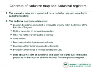
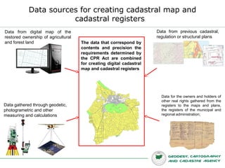
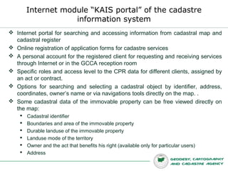
Presentation of Eng. Stefan Petrov, head of department GIS, GCCA (Bulgaria) at the 2nd workshop of GeoSkills+ project, held in Sofia from 27th to 29th of October 2014.
Smart Successful Cadastral New Tools for Real Estate Registration “All in 16...Carlos Alonso Peña
The Smart System of coordination between the Cadastre and the Property Rights Registry is now operational, producing results and involving all agents active in the Real Estate market. The tools, systems and protocols developed by the Directorate General of Cadastre are being widely used
After many attempts for coordination between the Cadastre and Property Rights Registry in Spain for more than a century, a new legal frame (law 13/2015) that give real estate traffic greater legal certainty by incorporating the georeferenced graphic information of the parcels in the Property Rights Registry has been enforced. It has put into place a mechanism for exchange INSPIRE CP GML that has permitted the coordination of the information of both institutions for a better identification and description of real estates and an adequate provision of services to citizens and administrations.
Spanish Cadastre an Property Rights Registry. A smart model of coordinated in...Carlos Alonso Peña
Reforms introduced legally in 2015 established that the description of properties in the Property Rights Registry is to be done by a georeferenced graphical representation.
To achieve this goal, it has been necessary to establish a smart model of coordinated interaction between Cadastre and Registry
The document discusses several challenges facing Ukraine's State Service of Ukraine for Geodesy, Cartography and Cadastre and proposes reforms to address them over the period of 2019-2021. The key challenges include corruption, an unfriendly user approach, lack of open information, overconcentration of authority, overregulation, and outdated topographic data. The proposed reforms are organizational reform of the agency, increasing transparency, digitalization, deregulation, simplifying procedures, opening up land and geospatial data, updating valuation methods, and establishing a national spatial data infrastructure. The reforms aim to improve public services related to land management and make better use of geospatial data.
Urban Land Record and Management: Current practices & Challenges and way forwardWaseem Sajjad
What are the main urban land record and management in Pakistan--a case study of Lahore
What is Patwari Culture? What are the problems of Patwari Culture?
Land Record Management and Information System LRMIS
The document provides an overview of the Land Records Management & Information Systems (LRMIS) Project in Pakistan. It discusses the historical context and need for the project to modernize outdated land record systems. It then outlines the objectives, design, implementation status and services provided by the LRMIS Project. Key highlights include completion of scanning and data entry in most districts, operationalization of online services, efforts to increase awareness and political support, and recognition of the project's success by various organizations. Value addition projects are also mentioned to further improve land administration.
Uttam Pudasaini gives a presentation on geomatics, which involves determining the precise position of objects on Earth and representing spatial information digitally. Geomatics incorporates fields like geodesy, surveying, GPS, remote sensing, photogrammetry, GIS and programming for spatial data analysis. It is a rapidly developing industry focused on collecting and analyzing location-based information. Geomatics engineers design systems to gather and study data about land, oceans, natural resources and man-made structures to support decision-making. The career was entered due to advice, scholarships and its dynamic nature combining mathematics, computers, travel and policy work.
In the preparation for the Geodetic Engineering Licensure Examination, the BSGE students must memorized the Laws, Rules and Regulations governing the CADASTRAL AND PUBLIC LAND SUBDIVISION SURVEY in the Philippines, execute the survey, preparation of CADASTRAL AND PUBLIC LAND SUBDIVISION SURVEY survey returns and IVAS of CADASTRAL AND PUBLIC LAND SUBDIVISION survey returns.
Pamela Weisberger (President and Research Coordinator, Gesher Galicia Inc.) on “Using unique and unusual archival records and data to illustrate and annotate historical maps, bringing vanished communities to life” held on 28.04.2015 at the international conference "Archival Cooperation and Community Building in the Digital Age" within the panel “Geospatial Genealogy, Cadastral Maps and Digital Archives: Partnerships and Collaborations" at Břevnov Archabbey in Prague (CZ).
3D Web Services And Models For The Web: Where Do We Stand?Camptocamp
Theme: Data: presentations focused on data (be it capture, storage, discovery or new data models such as 3D, temporal data, big data).
The aim of this talk is to sum up the standardization efforts (OGC and W3C) in defining 3D web services and models, as well as to show existing implementations to support the discussion.
In the past years, numerous open source projects have started to display 3D globes and 3D data on the web. Standardizing web services, data format and representation models is, therefore, a very hot topic. There are in particular ongoing efforts on the OGC side as well as on the W3C side. The OGC has released a draft candidate for a 3D web service W3DS, the ISO X3D standard proposes an XML-based file format for representing 3D computer graphics and the W3C is considering adding X3D rendering into HTML5. Other projects implement their own web services and formats. On the implementation side, Geoserver supports W3DS and X3D, the X3DOM library prototypes a possible implementation of X3D HTML5 integration and last but not least, browsers with WebGL support are fully able to handle the representation of 3D data on the client side. The talk is going to detail the mentioned elements, show demonstrations of existing implementations and try to suggest a possible path into the 3D web for the FOSS4G community.
This document establishes standards for digital cadastral maps and parcel identifiers. It describes the core components of a digital cadastral mapping system, including geodetic networks, imagery, cadastral map layers, and parcel identifiers. The standards are intended to provide guidance for developing and maintaining digital cadastral mapping programs to support property assessment.
Tips for Manipulating Data in Esri Geodatabase using FME Safe Software
Discover how to save time reading, writing and updating data in Esri Geodatabase. You’ll see how to easily load disparate datasets into either Enterprise, File, or Personal Geodatabase; plus how to quickly update and extract data according to your specifications. You’ll also receive tips for efficiently working with domains, subtypes, and annotation – to ensure high quality data.
1. Una geodatabase es una base de datos diseñada para almacenar, consultar y manipular datos espaciales como puntos, líneas y polígonos. 2. Contiene elementos como clases de entidades, conjuntos de datos raster, tablas y topología para definir las relaciones espaciales. 3. Permite crear dominios de atributos para restringir los valores de los campos y mejorar la integridad de los datos.
Este documento presenta una introducción a las geodatabases y al Sistema de Información sobre Ocupación del Suelo de España (SIOSE). Explica cómo los estudiantes importarán datos del SIOSE a una base de datos PostGIS y realizarán consultas SQL para distinguir entre usos urbanos y no urbanos del suelo como parte de un ejercicio práctico. El objetivo es que los estudiantes adquieran habilidades fundamentales de bases de datos geoespaciales y programación SIG que puedan aplicar en su futuro profesional.
In the preparation for the Geodetic Engineering Licensure Examination, the BSGE students must memorized the Laws, Rules and Regulations governing the GEODETIC CONTROL SURVEY in the Philippines, execute the survey, preparation of GEODETIC CONTROL SURVEY survey returns and IVAS of GEODETIC CONTROL SURVEY returns.
Introducción a SQL. En esta segunda presentación se trabaja con Postgres/Postgis por primera vez. El objetivo es dar un rápido vistazo a SQL y entender que para consultar el SIOSE con libertad es necesario conocer algún lenguaje de consulta.
Graduate Research Thesis Defense Presentation Johum Khushk
This document provides an overview of the design and development of a cadastral database for Pakistan. It begins with introducing key concepts related to cadastres and digital cadastral databases. It then discusses the existing paper-based cadastral system in Pakistan, including the organizations responsible for land records, processes, and types of land records. The document outlines the objectives of modeling the entities and relationships of the existing system and mapping them to international cadastral standards. It provides examples of translating existing paper records into database tables and developing a preliminary entity-relationship diagram. The document lays the groundwork for developing a digital cadastral database that standardizes Pakistan's land records.
Ozri 2013 Brisbane, Australia - Geodatabase EfficienciesWalter Simonazzi
The document discusses best practices for geodatabase design, storage, versioning, and performance management. It provides guidance to a new spatial data administrator, Dave, on assessing his organization's existing spatial data needs, creating a data model and governance plan, importing data, and collaborating with the database administrator to optimize database performance over time. Key topics covered include geodatabase design, storage and migration strategies, when and how to implement versioning, using replication to distribute data, and techniques for maintaining optimal performance such as attribute indexing, statistics, and scheduling maintenance tasks.
Plane Table Surveying is a graphical method of survey in which the field observations and plotting are done simultaneously.
It is simple and cheaper than theodolite survey. It is most suitable for small scale maps.
The plan is drawn by the surveyor in the field, while the area to be surveyed is before his eyes. Therefore, there is no possibility of omitting the necessary measurements.
How to use Logistic Regression in GIS using ArcGIS and R statisticsOmar F. Althuwaynee
This document outlines a course on using logistic regression in GIS applications with R. It discusses using logistic regression to create susceptibility maps by predicting the probability of landslides. It introduces key concepts like binomial logistic regression and dependent/independent variables. It also presents the equations that underlie logistic regression models and how they are used to calculate probability. The goal is for students to learn how to develop logistic regression models and maps in R and evaluate their accuracy.
Geodatabase: The ArcGIS Mechanism for Data ManagementEsri South Africa
This presentation is about understanding the content that goes into a geodatabase, advantages of using geodatabases, data management and maintaining data integrity.
Enterprise geodatabase sql access and administrationbrentpierce
The document provides an overview of accessing and administering an enterprise geodatabase through SQL and Python. It discusses how the geodatabase is based on relational database principles with user data stored in tables and system metadata stored in system tables. It describes how spatial types store geometry data and the benefits of using SQL to access and edit geodatabase content. The document also outlines how Python can be used for geodatabase administration tasks like schema creation, maintenance, and publishing tools.
This document discusses OpenWebGlobe 2, a new version of an open source project for visualizing 3D city models on the web. Some key points:
- It allows visualization of 3D models as both interactive 3D globes and as 2D map tiles for minimal bandwidth usage.
- The data processing is primarily done using Python code, with rendering done using a new Ray Tracing library called pyRT.
- It features an improved architecture with support for various scales from individual buildings to entire planets.
- Docker is used for development and deployment of the processing tools and sample web services.
Visualisation of Complex 3D City Models on Mobile Webbrowsers Using Cloud-bas...Martin Christen
Talk at Geospatial Week 2015 in La Grande Motte (near Montpellier), France. The paper is available at: http://www.isprs-ann-photogramm-remote-sens-spatial-inf-sci.net/II-3-W5/517/2015/isprsannals-II-3-W5-517-2015.pdf
The state land cadastre of belarus moving forwardLAZOVOY
The State Land Cadastre of Belarus has made progress in digitizing and streamlining the real property registration system. About 60-70% of land parcels, buildings, and apartments are now registered. Key developments include establishing a network of registration agencies in 2000, adopting legislation in 2002, digitizing registration in 2004, and creating web services starting in 2005. The registration process takes about a week and involves various agencies. The National Cadastral Agency oversees quality control and provides public access to registration data and reports through various e-services portals. Plans are underway to fully digitize paper archives, implement an extraterritorial registration system, and launch a new NKA_NET3 system for real-time online registration
Kadaster in the Netherlands provides registry, administration, and distribution services for property and geographic information. It aims to be a central point for this information in the Netherlands and influential in Europe. Kadaster registers over 8 million parcels and 1.9 million ships, produces over 20 million information products annually, and manages the national geodetic reference network and topographic maps. It provides information to various customer groups including government, businesses, and individuals.
The presentation describes the web-based electronic services of the Hellenic Cadastre. In fact, Hellenic Cadastre has developed a new set of web-based services that enable professionals and individuals to get online access to cadastral data and carry out typical cadastral transactions. Such transactions involve overviewing cadastral data, ordering certificates, and carrying-out land transactions. Access to those data and services is available, online, on a 24/7 basis, through the Hellenic central e-government portal.
The services were developed almost exclusively by the Agency’s IT Department. Their incorporation into the governmental e-portal was made in close cooperation with the Ministry of Digital Governance. The new services were based on the ITC infrastructure that had been developed in the past by the Hellenic Cadastre and comprise a portion of a wider plan to open-up cadastral data and services to the public. Those services were presented to the Prime Minister of the country by the Minister of Digital Governance on April 2021 and have attracted wide attention from the media and the public since then. In fact, they are in heavy use by the involved individuals and professionals since then and have helped in alleviating congestion in the cadastral offices, particularly during the Covid-19 pandemic surge in 2021.
The major benefits of the provided services are:
• On-line, 24/7, direct access to cadastral data and services to all those who have a legitimate interest in the cadastral data
• Easy access through a well-known focal e-governmental portal
• Elimination of the need for individuals to visit cadastral offices
• Avoidance of congestion in the cadastral offices
• Faster service to those interested in land transactions
• Speedier resolution of cadastral registration problems
• Improved support of planning and developmental activities.
The Government Introduces Electronic Certificate for Land RegistrationAHRP Law Firm
On 12 January 2021, the Minister of Agrarian Affairs and Spatial Planning/the Head of National Land Agency introduces MoAA Reg. No. 1/2021 on Electronic Certificate, which came into effect immediately. This regulation is one of the efforts to improve the quality of public services in the land sector by utilizing modern integrated technology in conducting land registration, as such, it is expected that the issuance of MoAA Reg. No. 1/2021 will accelerate the land service process and improve its efficiency.
The document summarizes proposed revisions to three Mongolian laws:
1) The draft revised law on state registration aims to improve transparency while protecting personal privacy. It allows for electronic access and sharing of property information between registration and cadastral databases.
2) The draft revised law on registration of property rights integrates land and property registration and allows professionals to assist with applications. It provides more detailed first-time registration procedures.
3) The draft revised law on public service defines public service and government organizations. It establishes public oversight of government performance and requires customer satisfaction surveys.
This document contains the Ekiti State Government
Reform Strategies on Properties Registration.
Previous reforms not captured by the World Bank:
1. Staffing of Property Registration Office with Professional Land Officer
2. Delegation of Signing of C of O to the Deputy Governor.
3. Computerization of property registration records to facilitate searches, retrieval of certified true copy, processing of consent etc.
This document discusses land administration and the role of GIS. It describes how land administration involves recording ownership and other attributes of land. GIS helps with land administration by providing digital maps and data for tasks like land registration, valuation for taxation, planning, and dispute resolution. The document also presents a case study of a GIS-based land information system developed for rural areas in India, which digitized paper maps, integrated satellite imagery, and allowed for more accurate planning and management of land use.
Cadastral surveying involves determining land boundaries and defining ownership through surveys. It provides legally defined boundaries and documents ownership. There are several types of cadastres including fiscal for taxation, legal for ownership rights, and multi-purpose for combined legal, fiscal and other land information. Cadastres have significance for facilitating land transactions, providing security of ownership, and supporting planning, taxation and dispute resolution. Ethiopia has undertaken several cadastral projects since the early 1900s to modernize its land administration system.
The document provides updates on draft revised laws regarding state registration and property rights registration in Mongolia. Key changes in the draft laws include:
1) Adding pledges and finance leases as registrable property rights. Allowing electronic access to registration information and requests.
2) Integrating land and property registration and allowing professionals to assist with registrations. Requiring more information be disclosed for property transfers and amendments.
3) Specifying how residential and common properties will be registered. Allowing electronic applications and defining mortgage priority based on registration sequence.
This document provides an overview of land information systems (LIS) with a focus on India. It discusses the components and purpose of LIS, provides historical background on land administration systems in Western countries and India, and reviews examples of LIS implementation internationally and within states in India. Key components of LIS discussed include spatial and non-spatial data, cadastral mapping, and land records. The benefits of LIS for land management are also summarized.
Digitization Land Records of Revenue (DLRR).
A Pilot Project of 2010 Flood affected areas Under PSFRP Project funded by Government of Japan in 2012 in Khyber Pakhtunkhwa (KPK) .
Project Manager Syed Subtain Hussain - ssbacha@gmail.com
The document summarizes the development of the Serbian Business Registers Agency's (SBRA) information system from its establishment in 2005 to the present. Key points include:
- SBRA was established in 2004 as part of business registration reform in Serbia to simplify the registration process and create a favorable business environment.
- The initial information system was developed from 2005-2009 to support SBRA's core registers and services through donations and technical assistance.
- Current initiatives through 2010-2011 aim to advance the system's architecture using service-oriented principles and establish SBRA as a hub for sharing business and economic data across government agencies.
This document outlines reforms to decentralize power in Ukraine by reforming local self-government and territorial administration. Key points include:
- Establishing around 1,470 territorial hromadas (amalgamated communities) and reducing rayons (districts) from 490 to around 129.
- Distributing competences and finances between local self-governments at the primary (hromada), rayon and oblast levels, with primary hromadas gaining more own competences.
- Reforming laws on local self-government, local state administrations, and procedures for territorial reorganization to support the new administrative system.
- Adjusting the budget code to reflect the new competences and finances
NDGISUC2017 - 2020 Census Local Update of Census Addresses Operation (LUCA)North Dakota GIS Hub
The document provides information about the 2020 Local Update of Census Addresses Operation (LUCA). It discusses the purpose and uses of the decennial census. It describes who can participate in LUCA and what's new for 2020 including streamlined participation and standardized digital address formats. It outlines the LUCA schedule, available tools, product preferences including Geographic Update Partnership Software and paper/digital formats, and next steps for participants to prepare and register.
This document discusses the key components and procedures of cadastre. It outlines that cadastre involves cadastral surveying and mapping to provide information for cadastral maps, as well as land registration and title certification to improve land management and reduce boundary disputes. It also notes that property taxation supports municipal governments and is a major source of revenue. The roles of surveyors include creating, re-establishing and determining land boundaries to define parcels and create accurate cadastral maps and records. The procedures for cadastral surveying involve survey planning, boundary confirmation, surveying boundaries, making cadastral records and maps, and submitting the final products to the land registry office.
The main aim (purpose) of the IMPULS project has been to assist beneficiary organisations in the Western Balkan region to develop cross-border compati-ble National Spatial Data Infrastructures (NSDI’s) in accordance with the principles of the European INSPIRE Directive.
The project has been funded by Sida (Sida’s contribution no: 55020189) and implemented in the region of Western Balkan from June 2014 to December 2019.
The Expected Project impacts have been:
• INSPIRE Directive is implemented in the region, enabling the beneficiary countries to meet the EU-requirements in this area;
• Interoperable content and services are delivered efficiently, supporting the development of e-government in each country as well as adding value to government and local administration, all in accordance with the Public-Sector Information (PSI) Directive; and
• Implementation of the INSPIRE Directive, supported through this project, has contributed to the economic development, transparency of ownership and anticorruption processes, in accordance with SEE 2020 (specifically in the dimensions” Competitiveness”, “Effective public services” and “Anti-corruption”.
Following outcomes has been expected:
• Beneficiary Organisations understand how they contribute to an efficient SDI and have a clear view of the different SDI roles (user, producer and coordinator) and there are mutual respects between agencies having these roles throughout the region.
• Beneficiary Organisations are using data from other sources, both national and regional, and using the different components in the SDI (metadata, portal, services etc.) when producing, using and providing data.
• Beneficiary Organisations are proactively driving the SDI-work and re-moving obstacles to share data in the region as well as actively developing and promoting NSDI’s. Beneficiary Organisations are working in national and regional forums with different organisations as the normal way of working, using the network and roles initiated by the IMPULS project for regular meetings and ad hoc task force when needed.
Lantmäteriet has been the implementing partner of the project, working to-gether with the State Geodetic Administration of the Republic of Croatia (SGA).
The beneficiary organisations in the Wester Balkan region have been:
• State Agency of Cadastre (SAC), previously Immovable Property Central Registration Office of the Republic of Albania (IPRO)
• State Authority for Geospatial Information in Albania (ASIG)
• Federal Administration for Geodetic and Real Property Affairs of FB&H (FGA)
• Republic Authority for Geodetic and Property Affairs of the Republic of Srpska (GARS)
• Kosovo Cadastral Agency (KCA)
• Agency for the Real Estate Cadastre of the Republic of North Macedonia (AREC)
• Real Estate Ad
The document discusses transitioning all Wisconsin assessment data to electronic formats by 2013 and including photos and sketches by 2015. It covers topics related to the evolving land records modernization process, including data standards and sharing, process improvements, finances, ownership, and protection of electronic records. The forum will address issues surrounding the over 3 million parcels in Wisconsin's land records system as it continues to modernize.
Portal Of Public Services Of Russian Federation (Psir V2)Victor Gridnev
The document discusses proposals for developing a unified system of public services in Russia using information and communication technologies (ICT). It proposes creating a single federal portal and register of public services that would integrate regional portals and registers. This would provide citizens and businesses with unified access to information about and delivery of public services from all levels of government. It aims to standardize processes, reduce costs, and ensure equal access to services across Russia through use of ICT.
Integration of Khartoum Cadastral Information into State and Sudan Base Mapijtsrd
The study aims to evaluate and improve Aboadam locality Khartoum State, digital cadastral map layer and to look into its integration possibility with Khartoum State Basemap as well as Sudan National Basemap system. To achieve this objective many approaches have been attempted based on the knowledge of the process steps used to develop the dataset together with the related errors. The approach to estimate the positional accuracy of the cadastral dataset derived from the digital cadastral land maps were reviewed. Then positional data was collected by the aid of GNSS to coordinate the cadastral maps and to apply the geo references process to fit it with the previous Khartoum aerial photography mapping. Kamal A. A. Sami | Tagwa Mohamed Ali Elshiekh "Integration of Khartoum Cadastral Information into State and Sudan Base Map" Published in International Journal of Trend in Scientific Research and Development (ijtsrd), ISSN: 2456-6470, Volume-7 | Issue-6 , December 2023, URL: https://www.ijtsrd.com/papers/ijtsrd60144.pdf Paper Url: https://www.ijtsrd.com/engineering/other/60144/integration-of-khartoum-cadastral-information-into-state-and-sudan-base-map/kamal-a-a-sami
This document summarizes information from a workshop on cooperation models and education levels in geo-information in Bulgaria and the Netherlands. It provides details on available GI education programs in the Netherlands such as the levels, institutions, cities, and recent developments. It also discusses supply and demand of expertise in the GI industry by education level and how curricula are developed through key stakeholders from educational institutions, industry, professional associations, and government.
Exchange of best practices for transfer of innovation of GEO VET education to...Geoskills+ Project
This document summarizes the GEO SKILLS PLUS project, which aims to exchange best practices for transferring geospatial vocational education and training innovations between EU countries. The project involves cooperation between educational institutions and industry partners in multiple EU nations. It consists of several work packages focused on areas like awareness raising, bridging skills gaps, and dissemination of results. The project will identify existing cooperation examples and develop recommendations to better align geospatial education with changing labor market needs across Europe in accordance with EU policies.
GeoSuisse symposium meeting with Wageningen University and SAGEO on Geospatial Education Reinvented, September 12th, 2014, at Wageningen University, Netherlands.
This document outlines the "Capacity Building for the Future" programme organized by SAGEO. It discusses developments in geo education in Europe, SAGEO's activities, and the geo employment market in the Netherlands. Key points:
- SAGEO works with government, education, and industry representatives to align geo education with labor market needs.
- There is a mismatch between the supply and demand of geo graduates in the Netherlands. Industry demands around 325 graduates annually but only provides 16-23% of this demand.
- SAGEO received funding from the European Commission for a project called "GEO Plus" to innovate vocational training for land surveyors and better meet labor needs. The two-year
GeoCapacity Building - what future for 'geospatial geoskills'?Geoskills+ Project
This document summarizes the work of EUROGEO, the European Association of Geographers, in building capacity for geospatial skills. It discusses EUROGEO's role in networking geographers, lobbying the European Parliament, and running educational projects. It also addresses the future of geospatial skills and capacity building, noting the importance of international research networks, entrepreneurship, sustainability of projects, and filling the space between university, industry and government. Recommendations include long-term commitment from stakeholders, common public messaging, and evaluating risks of not developing capacity.
Karl Donert presented on the EUROGEO organization and its Geoskills Plus project. EUROGEO is a professional association for geographers that networks members and develops geospatial education and training programs. The Geoskills Plus project examines cooperation, awareness building, and bridging skills gaps regarding the geospatial workforce in Europe. It identifies existing examples in countries like the Netherlands and develops an implementation plan to address needs in Belgium, Bulgaria, and Lithuania. The project consists of five work packages and involves partners from multiple countries working together over two years to help align geospatial education and employment.
About Potato, The scientific name of the plant is Solanum tuberosum (L).Christina Parmionova
The potato is a starchy root vegetable native to the Americas that is consumed as a staple food in many parts of the world. Potatoes are tubers of the plant Solanum tuberosum, a perennial in the nightshade family Solanaceae. Wild potato species can be found from the southern United States to southern Chile
Synopsis (short abstract) In December 2023, the UN General Assembly proclaimed 30 May as the International Day of Potato.
Jennifer Schaus and Associates hosts a complimentary webinar series on The FAR in 2024. Join the webinars on Wednesdays and Fridays at noon, eastern.
Recordings are on YouTube and the company website.
https://www.youtube.com/@jenniferschaus/videos
AHMR is an interdisciplinary peer-reviewed online journal created to encourage and facilitate the study of all aspects (socio-economic, political, legislative and developmental) of Human Mobility in Africa. Through the publication of original research, policy discussions and evidence research papers AHMR provides a comprehensive forum devoted exclusively to the analysis of contemporaneous trends, migration patterns and some of the most important migration-related issues.
This report explores the significance of border towns and spaces for strengthening responses to young people on the move. In particular it explores the linkages of young people to local service centres with the aim of further developing service, protection, and support strategies for migrant children in border areas across the region. The report is based on a small-scale fieldwork study in the border towns of Chipata and Katete in Zambia conducted in July 2023. Border towns and spaces provide a rich source of information about issues related to the informal or irregular movement of young people across borders, including smuggling and trafficking. They can help build a picture of the nature and scope of the type of movement young migrants undertake and also the forms of protection available to them. Border towns and spaces also provide a lens through which we can better understand the vulnerabilities of young people on the move and, critically, the strategies they use to navigate challenges and access support.
The findings in this report highlight some of the key factors shaping the experiences and vulnerabilities of young people on the move – particularly their proximity to border spaces and how this affects the risks that they face. The report describes strategies that young people on the move employ to remain below the radar of visibility to state and non-state actors due to fear of arrest, detention, and deportation while also trying to keep themselves safe and access support in border towns. These strategies of (in)visibility provide a way to protect themselves yet at the same time also heighten some of the risks young people face as their vulnerabilities are not always recognised by those who could offer support.
In this report we show that the realities and challenges of life and migration in this region and in Zambia need to be better understood for support to be strengthened and tuned to meet the specific needs of young people on the move. This includes understanding the role of state and non-state stakeholders, the impact of laws and policies and, critically, the experiences of the young people themselves. We provide recommendations for immediate action, recommendations for programming to support young people on the move in the two towns that would reduce risk for young people in this area, and recommendations for longer term policy advocacy.
Digital cadaster in Bulgaria. Information system of cadaster and property register
1. Digital cadaster in Bulgaria.
Information system of cadaster
and property register
Eng. Stefan Petrov, head of department GIS, GCCA
Sofia, 2014
2. Digital cadastre and property register in Bulgaria - 1
Cadastre and property register act (CPRA) has been establish in 2001 and
it arranges new principles for the organization, funding, creation,
administration and use of the cadastre and the property register;
Geodesy, cartography and cadastre agency (GCCA) is an executive
agency established with main functions pursuant to the Cadastre and property
register act;
The Agency is a legal entity, having its seat in Sofia and operating through its
28 regional units – Geodesy, Cartography and Cadastre Offices (GCCO),
located in the administrative centres of the regions;
The cadastre is created, maintained and stored by the Agency for geodesy,
cartography and cadastre;
The property register is kept and stored by the Registry Agency;
3. Digital cadastre and property register in Bulgaria - 3
The cadastre and the property register are created, maintained up-to-date
and stored in digital form in Integrated information systems for cadastre
property register (IISCPR) ;
IISCPR deliver the bilateral connection between cadastre and the property
register, based on the identifier of immovable properties;
Cadastre and properties register are integrated and exchange information;
Users of digital cadastre and property register (CPR) data:
Cadastre and Property registration Agencies employees;
Specialists participating in CPR business processes (notaries, geodetic and
surveying companies;
Government and municipal institutions;
Private service companies (banks, property brokers, utilities, etc.);
End users (citizens, legal entities, media, etc.).
4. Contents of cadastre map and cadastral registers
The cadastre data are mapped out on a cadastre map and recorded in
cadastral registers;
The cadastre aggregates data about:
Location, boundaries and extent of immovable property within the territory of the
Republic of Bulgaria;
Right of ownership on immovable properties;
Other real rights over immovable properties;
State borders;
Boundaries of administrative-territorial units;
Boundaries of territories belonging to settlements;
Boundaries of territories of identical durable land use;
Data about the right of ownership and other real rights over immovable
properties in the cadastre shall be received from the property register.
5. Contents of the property register
The property register comprises the lots of the immovable properties.
In the property register are recorded:
the acts recognizing or conveying right of ownership;
the acts establishing, conveying, modifying and terminating other real right
over immovable properties;
interdictions and mortgages over the latter;
other legal actions, circumstances and legal facts for which recordation is
envisaged by law.
The basic data about the immovable properties in the property
register shall be received from the cadastre.
8. Territorial units – settlement lands
Municipalities are subdivided
into settlement lands;
Urbanized territory and
surrounding agricultural and
forest territories belonging to
the settlement are located
within its boundaries;
Every settlement has a unique
code (EKATTE) from the
Unified classifier of
administrative-territorial units;
The immovable properties
receive unique identifier
formed within the boundaries
of a settlement;
9. Data sources for creating cadastral map and
cadastral registers
Data from previous cadastral,
regulation or structural plans
Data for the owners and holders of
other real rights gathered from the
registers to the maps and plans,
the registers of the municipal and
regional administration;
Data gathered through geodetic,
photogrametric and other
measuring and calculations
Data from digital map of the
restored ownership of agricultural
and forest land The data that correspond by
contents and precision the
requirements determined by
the CPR Act are combined
for creating digital cadastral
map and cadastral registers
10. Immovable properties, objects in the cadastre
Landed property is the basic unit of the cadastre,
it is a part of the surface of the earth, including
durably covered with water, defined by boundaries
compliant with the right of ownership. The landed
properties is fully cover up the territory of the
country, defined by the state borders, without
overlapping each other.
Building, including also rough construction
(building or structure which surrounding walls and
roof have been made)
Self-contained object (SCO) in a building or in
a facility of the technical infrastructure - part of
the building or facility that has a self-dependent
function and building with exposed walls. SCO
can be an apartment, office, studio, garage, store
Each landed property, building or self-contained
object shall be attributed an identifier, a unique
number by which the immovable property is
singularly identified within the territory of the
country.
11. The unique identifier of an land property in cadastre
The territory of a settlement land is divided into cadastral regions
A cadastral region is limited by boundaries of settlement lands, boundaries of cities and boundaries of existing
linear objects or topographic forms on the land - roads, railways, rivers, gulches and other
Every cadastral region received a unique number within the boundary of the settlement land
A cadastral region contains land properties that receives a unique number within the boundary of the
corresponding cadastral region.
The unique identifier of an land property consists the EKATTE code of the settlement, the number of the
corresponding cadastral region and the sequent number within the boundary of the cadastral region, divided by
“dot”.
Boundary of a settlement land
with EKATTE code 06286
Cadastral region N76
within the boundary
of a settlement land
Land property N20
in the boundary of
a cadastral regions
Landed property identifier
06286.76.20
12. • Buildings receive sequent numbers within the land property they belongs. For creating the building
identifier this number is added at the end of the land property identifier
• Self-contained object (SCO) receive sequent numbers within the building they belongs. For
creating the SCO identifier this number is added at the end of the building identifier
The unique identifier of a Building and Self-
contained object in cadastre
Building N1 in parcel 06286.501.230
has identifier 06286.501.230.1
501
SCO N1 in building 06286.501.230.1
has identifier 06286.501.230.1.1
501
13. Cadastre Subsistem of the Integrated information
systems for cadastre property register (IISCPR)
Cadastral information system delievers:
Secure input, storage and update of data;
Automated and optimized business processes;
Processing of electronic reports, services and documents (maps, legal acts, etc.)
Exchange of data between GCCA and RA;
Exchange of data with external systems;
Main modules of Cadasral information system
Internet module “KAIS Portal”
Record keeping module “KAIS Office”
GIS module “Cadastre map and cadastre registers
Architecture of Cadastre information system
Database
replication
14. Internet module “KAIS portal” of the cadastre
information system
Internet portal for searching and accessing information from cadastral map and
cadastral register
Online registration of application forms for cadastre services
A personal account for the registered client for requesting and receiving services
through Internet or in the GCCA reception room
Specific roles and access level to the CPR data for different clients, assigned by
an act or contract.
Options for searching and selecting a cadastral object by identifier, address,
coordinates, owner’s name or via navigations tools directly on the map. .
Some cadastral data of the immovable property can be free viewed directly on
the map:
Cadastral identifier
Boundaries and area of the immovable property
Durable landuse of the immovable property
Landuse mode of the territory
Owner and the act that benefits his right (available only for particular users)
Address
15. Internet module “KAIS portal” of the cadastre
information system http://kais.cadastre.bg
16. Application forms for requesting services
via “KAIS portal”
Application forms for a service are filled in and sent to GCCA for
implementation
GCCA employees handle the request in the statutory dead-line
Depending on the final document result can be available electronically in the
client profile in KAIS or shall be received in the GCCA reception room.
Application forms for some services require to be digitally signed by the client
Three types applications for services are available for requesting via the
internet portal KAIS:
geokartfund service
legal services for activities of Geodesy, Cartography and Cadastre
services from the cadastral map and the cadastral registers (CMCR)
For the services of cadastral map and cadastral registers shall be paid fees
to amounts determined by a tariff approved by the Council of Ministers.
18. Reports in “KAIS portal”
Real time references, which are automatically generated by the system;
Free references of basic cadastre data of the immovable properties;
Free information for geodetic base points and their coordinates;
Available electronically in the client profile in KAIS;
Reports in *.pdf format from cadastral map and cadastral registers;
A copy of the cadastral map and cadastral registers in digital vector
format;
Reports for geodetic base points;
For some reports of cadastral map and cadastral registers shall be paid
fees to amounts determined by a tariff approved by the Council of
Ministers.
19.
20.
21.
22. Record keeping module “KAIS Office” of the
cadastre information system
Web based documentation modul for GCCA employees for management of:
incoming general documents and application forms for cadastre services;
outgoing documents;
paid orders for services;
client information;
Specific roles and access level to the module for the employees, according
their position and office duties
Main components of KAIS Office:
MAP – provides many functions for searching, identifying and selecting cadastral
objects on the map by identifier, address, coordinates, owner’s name;
DOCUMENTS – provides management of all incoming and outgoing documents –
registration, editing, printing, assigning for processing, history of a document, status
of correspondences;
CLIENTS – provides registration and management of the clients data. Every
registered client in the system has a single file that keeps his personal data and full
history of the customer’s applications, paid orders, personal contracts for services
REPORTS – provides preparation of different kind of reports for incoming
documents, clients, payments, contracts.
25. Module “Cadastre map and cadastre registers”
(CMCR)
GIS Desktop software for GCCA employees, provides:
Import new cadastre map and cadastre registers into the database;
Processing projects for editing and updating of cadastre data;
Loading external spatial data;
Exporting cadastral data in digital vector format;
Issue of reports, certificates, sketches, diagrams and excerpts from the cadastre
map and cadastre register;
Historical reports for changes in immovable properties.
Specific roles and access level to the module for the employees, according
their position and office duties
Three modes of the module “CMCR”:
Cadastre map – for managing the spatial data of cadastral objects;
Cadastre registers – for managing the attribute data cadastral objects;
Thematic maps – for managing thematic maps, sketches and excerpts from
cadastre;
29. Most required cadastre services, delivering by
cadastre information system
Application of changes in the cadastral map and cadastral registers
Adding new immovable properties
Reflecting changes in the boundaries and attributes of immovable properties
Working out of design for partition of landed property
Working out of design for consolidation of land properties
Reflecting changes for buildings that are removed
Issuing legal documents of immovable properties
Issuing a sketch of a landed properties or a building
Issuing a scheme of self-contained object
Issuing a sketch of a property with additional cadastral data
Issue a combined sketch for full or partial identity of the boundaries of land
Issue of transcript from the cadastral register of real estate in writing
Issuance of certificate for identity of a landed property
Information about the points of geodetic work
Copy of the cadastral map in digital or graphic format
30. Coverage with cadastre map and cadastre registers
corresponding the requirements of the CPR Act
Coverage 18,3 % of the territory,
over 7 millions immovable properties
3 002 655 landed properties
1 966 316 buildings
2 111 258 self-contained object
Priorities in the
creation of CMCR:
- District centers;
- Municipality centers;
- Areas with increased
investment interest (coast,
mountain and beach
resorts, border areas,
areas with intensive and
active land market
development )
31. Present and future development of GCCA
information systems
Cadastre information system
Migrating from decentralized model to centralized model of cadastral database
Migrating to open source Database management system (DBMS) – PostGRESQL
Coordinate transformation of the cadastral data to coordinate system BGS2005
Implementation of a new file format for cadastral data based on OGS standarts
Implementation of INSPIRE data specifications for as developed by the
Thematic Working Group
Harmonization of spatial data sets and implementation of INSPIRE data
specifications for the Thematic Working Group:
• Coordinate reference systems
• Geographical names
• Cadastral parcels
Metadata for the spatial data sets
Establish and operate a network services for the spatial data sets and metadata
Development of new information systems
Information systems of Geokartfund
Informations system for specialized maps under Act on the black sea coast spatial
development
33. Thank you for your attention!
WWW.CADASTRE.BG
KAIS.CADASTRE.BG
eng. StefanPetrov
Head Of Department "Geoinformation systems"
1, Musala Str., Pavlovo, 1618 Sofia
Tel.: + 359 2 8188360, Fax: +359 2 9555333
e-mail: petrov.s@cadastre.bg
www.cadastre.bg