
Recommended
More Related Content
What's hot
What's hot (20)
Similar to Deposition Review
Similar to Deposition Review (20)
More from West Hollow MS Ms. Gill
More from West Hollow MS Ms. Gill (20)
Recently uploaded
Recently uploaded (20)
Deposition Review
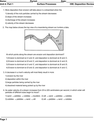
- 1. Name:______________________ Period:______________________ Date:_______________________ Unit 4: Part 1 Surface Processes HW; Deposition Review 1. More deposition than erosion will take place in a streambed when the 1) density of the rock particles carried by the stream decreases 2) slope of the stream increases 3) discharge of the stream increases 4) velocity of the stream decreases 2. The map below shows the top view of a meandering stream as it enters a lake. At which points along the stream are erosion and deposition dominant? 1) Erosion is dominant at A and D, and deposition is dominant at B and C. 2) Erosion is dominant at B and C, and deposition is dominant at A and D. 3) Erosion is dominant at A and C, and deposition is dominant at B and D. 4) Erosion is dominant at B and D, and deposition is dominant at A and C. 3. A decrease in a river's velocity will most likely result in more 1) erosion by the river 2) deposition within the river 3) large particles being carried by the river 4) dissolved material being picked up by the river 4. As water velocity of a stream increases from 25 to 225 centimeters per second, in which order will particles of different sizes begin to move? 1) sand ® pebbles ® cobbles ® boulders 2) silt ® sand ® pebbles ® cobbles 3) cobbles ® pebbles ® sand ® silt 4) silt ® pebbles ® sand ® cobbles Page 1
- 2. Name:______________________ Period:______________________ Date:_______________________ Unit 4: Part 1 Surface Processes HW; Deposition Review Base your answer to the following question on the photograph below, which shows a mountainous region cut by a large valley in its center. 5. What characteristic of this large valley supports the inference that glacial ice formed the valley? 6. The table below describes the deposits that an observer saw while walking downstream along a 500 meter section of a streambed. It could be inferred from the above data that the stream's velocity 1) was constantly decreasing 2) was constantly increasing 3) decreased and then increased 4) remained the same 7. Why do the particles carried by a river settle to the bottom as the river enters the ocean? 1) The density of the ocean water is greater than the density of the river water. 2) The kinetic energy of the particles increases as the particles enter the ocean. 3) The velocity of the river water decreases as it enters the ocean. 4) The large particles have a greater surface area than the small particles. Page 1
- 3. Name:______________________ Period:______________________ Date:_______________________ Unit 4: Part 1 Surface Processes HW; Deposition Review 8. A river carrying pebbles, sand, silt, and clay flows into the ocean. The sediments are sorted by size as they are deposited at different distances from shore. Which sedimentary rock will most likely form from the sediment deposited farthest from shore? 1) conglomerate 2) sandstone 3) siltstone 4) shale 9. What is the minimum rate of flow at which a stream can maintain transport of boulders? 1) 100 cm/sec 2) 200 cm/sec 3) 300 cm/sec 4) 400 cm/sec Base your answer to the following question on the Earth Science Reference Tables and the diagram below. The diagram shows air movements associated with cumulus cloud formation over a lake during a summer day. A, B, C, and D are reference points. 10. As the air rises past point C, the temperature of the air will 1) decrease as its volume decreases 2) decrease as its volume increases 3) increase as its volume decreases 4) increase as its volume increases Page 1
- 4. Name:______________________ Period:______________________ Date:_______________________ Unit 4: Part 1 Surface Processes HW; Deposition Review 11. The diagram below shows a stream profile before and after an earthquake. Points A and B are locations along the streambed. What is the probable relationship between erosion and deposition at points A and B after the earthquake? 1) There is more deposition at point A and more erosion at point B. 2) There is more erosion at point A and more deposition at point B. 3) There is more deposition than erosion at points A and B. 4) There is more erosion than deposition at points A and B. 12. What is the minimum water velocity needed in a stream to maintain the transportation of the smallest boulder? 1) 100 cm/sec 2) 200 cm/sec 3) 300 cm/sec 4) 500 cm/sec 13. A stream flowing at a velocity of 75 centimeters per second can transport 1) clay, only 2) pebbles, only 3) pebbles, sand, silt, and clay, only 4) boulders, cobbles, pebbles, sand, silt, and clay 14. Which rock particles will remain suspended in water for the longest time? 1) pebbles 2) sand 3) silt 4) clay Page 1
- 5. Name:______________________ Period:______________________ Date:_______________________ Unit 4: Part 1 Surface Processes HW; Deposition Review 15. Which graph best shows the general relationship between stream velocity and the diameter of particles transported by a stream? 1) 2) 3) 4) 16. A sample of rounded quartz sediments of different particle sizes is dropped into a container of water. Which graph best shows the settling time for these particles? 1) 2) 3) 4) 17. The velocity of a stream is decreasing. As the velocity approaches zero, which size particle will most likely remain in suspension? 1) clay 2) pebble 3) sand 4) boulder 18. Quartz particles of varying sizes are dropped at the same time into deep, calm water. Which cross section best represents the settling pattern of these particles? 1) 2) 3) 4) 19. Two streams, A and B, carry the same volume of water, but stream A has a greater velocity. The most likely cause of this greater velocity would be that stream A 1) has more tributaries 2) has a wider streambed 3) flows down a steeper slope 4) travels over less resistant bedrock Page 1
- 6. Name:______________________ Period:______________________ Date:_______________________ Unit 4: Part 1 Surface Processes HW; Deposition Review 20. The four objects below are made of the same material and have the same mass. Which object will settle fastest in calm water? 1) 2) 3) 4) Page 1
- 7. Name:______________________ Period:______________________ Date:_______________________ Unit 4: Part 1 Surface Processes HW; Deposition Review 21. The map below shows the surface bedrock in an area of the southwestern United States that formed from sediments deposited in a shallow sea that formerly existed in that area. These sediments were transported by a river that flowed into the sea. In which diagram does the arrow best show the direction of flow of the river that deposited these sediments and the point at which the river emptied into the sea? 1) 2) 3) 4) Page 1
- 8. Name:______________________ Period:______________________ Date:_______________________ Unit 4: Part 1 Surface Processes HW; Deposition Review 22. Diagram I below shows a laboratory setup for observing the settling pattern in water of sediments composed of the same mineral. When the sediments in the container were poured into the tube of water, they settled to the bottom in the pattern shown in diagram II below. [Diagram II is enlarged to show the sedimentary particles.] Which characteristic of the sedimentary particles most likely caused the pattern of deposition shown in diagram II? 1) particle shape 2) particle size 3) particle composition 4) particle density 23. A stream entering a lake deposits sediments on the lake bottom in the pattern shown on the map below. Which corner of the map is nearest to the point where the stream flows into the lake? 1) northeast (NE) 2) northwest (NW) 3) southeast (SE) 4) southwest (SW) Page 1
- 9. Name:______________________ Period:______________________ Date:_______________________ Unit 4: Part 1 Surface Processes HW; Deposition Review 24. The diagram below shows four identical columns containing the same amount of water. Four different-sized spherical particles, made of the same uniform material, are dropped into the columns and settle to the bottom. Which graph best shows the relative settling times of the four particles? 1) 2) 3) 4) 25. The four particles shown in the table below are of equal volume and are dropped into a column filled with water. Which particle would usually settle most rapidly? 1) A 2) B 3) C 4) D Page 1
- 10. Name:______________________ Period:______________________ Date:_______________________ Unit 4: Part 1 Surface Processes HW; Deposition Review 26. The table below shows the density of four mineral samples. If the shape and size of the four mineral samples are the same, which mineral will settle most slowly in water? 1) cinnabar 2) magnetite 3) quartz 4) siderite Base your answer to the following question on the map below, which shows the drainage basin of the Mississippi River system. Several rivers that flow into the Mississippi River are labeled. The arrow at location X shows where the Mississippi River enters the Gulf of Mexico. 27. Sediments deposited at location X by the Missisippi River most likely have which characteristics? 1) angular fragments arranged as mixtures 2) rock particles arranged in sorted beds 3) rocks with parallel scratches and grooves 4) high-density minerals with hexagonal crystals Page 1
- 11. Name:______________________ Period:______________________ Date:_______________________ Unit 4: Part 1 Surface Processes HW; Deposition Review Base your answer to the following question on the diagram below, which shows a clear plastic tube contain ing water and a beaker containing a mixture of rounded quartz grains of different sizes. 28. The side-view diagram above shows the same mixture and amount of rounded quartz grains being poured all at once into a moving stream with a depth of 3 meters. Describe the general location of the 2-mm-diameter rounded quartz grains compared to the 4-mm-diameter rounded quartz grains as they are transported and deposited downstream. Page 1
- 12. Earth Science Name _________________ Class _________________ Date _________ 1. 2. 3. 4. 5. 6. 7. 8. 9. 10. 11. 12. 13. 14. 15. 16. 17. 18. 19. 20. 21. 22. 23. 24. 25. 26. 27. 28. Page 1