eGeoBriefAfghanistan facilities
•
0 likes•97 views

eGeoBrief - Afghanistan - Facilities The Facilities presentation was produced in October 2001. The overall eGeoBrief has presentations for History, Geography, Politics, Communications, Facilities, Resources, Economy and Envronment. CAUTION: Information contained in this product has been compiled from a range of sources from the Internet. Information has NOT been independently validated. This product has been developed as a ‘proof of concept’ for electronic geographic briefs (eGeoBrief)

Recommended
More Related Content
What's hot
What's hot (14)
More from Robert (Bob) Williams
More from Robert (Bob) Williams (20)
Recently uploaded
Recently uploaded (20)
eGeoBriefAfghanistan facilities
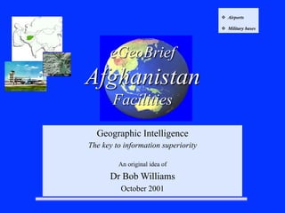
- 1. eGeoBrief Afghanistan Facilities Geographic Intelligence The key to information superiority An original idea of Dr Bob Williams October 2001 v Airports v Military bases
- 3. Kabul International Airport (KBL) Kabul-Khwaja Rawash Airport (KBL/OAKB) Airport contact Manager of Airport Operations Kabul International Airport P.O. Box 76 Ansair Watt Kabul, Afghanistan Telephone: 25541/5 Elevation: 5871 FT MSL Runways In Use: 29/11 Runway Information Orientation Length (ft) Threshold (ft) Glide Slope(deg) Width (ft) 11/29 9187 Remarks: Visual Approach Procedures Trans Level: FL 110 Final Approach: Expect wind shear on final approach KB and end of RWY 29 when surface wind is 15 KT or more Kabul Approach: 120.30 Kabul Tower: 118.10 ILS: N/A NDB: N/A VOR: N/A 10 mile from city. Airport facilities include banking, buffet-bar, car park, post office & restaurant ( 0700-2400). Taxis ride time – 30 minutes Geography History Environment Economy Politics Communications Facilities Resources FACILITIES eGeoBrief Kabul Intl. • AIRPORTS 34°34'00"N 69°12'32"E
- 4. Geography History Environment Economy Politics Communications Facilities Resources FACILITIES eGeoBrief Bagram Airbase • AIRPORTS Bagram Airbase is located in the Parvan Province approximately 11 kilometers (7 miles) southeast of the city of Charikar and 47 Kilometers (27 miles) north of Kabul. The Airfield is served by a 10,000 foot runway built in 1976 capable of serving large cargo and bomber aircraft. Facilities Bagram Airbase has three large hangers, a control tower, and numerous support buildings. There are over 32 acres of ramp space. There are five aircraft dispersal areas with a total of over 110 revetments. Many support buildings and base housing built by the Soviets, have been destroyed by years of fighting between the various warring Afghan factions. www.globalsecurity.org/military/world/afghanistan Hangars Airport Type Runway length Latitude Longitude Bagram Military 9,842 feet 34°56'46"N 69°15'54"E
- 5. Geography History Environment Economy Politics Communications Facilities Resources FACILITIES eGeoBrief Duranta Camp • MILITARY BASES The Al-Badr I base in Jalalabad [34°25'00"N 70°27'00"E] is about 120 kilometers east of Kabul. The Tora Bora base near Jalalabad was rebuilt on the site of a camp first constructed by the US Central Intelligence Agency in the early 1980s. According to one report, bin Ladin's "Abu Khabab" camp is focused on development and training with chemicals, poisons and other toxins. This camp is named after the Egyptian who runs it, Midhat Mursi — who uses the name Abu Khabab. The camp, about eight miles from Jalalabad, is part of a complex of training sites known as Darunta [34°28'00"N 70°22'00"E], after a nearby stone dam. www.globalsecurity.org/military/world/afghanistan
- 6. Geography History Environment Economy Politics Communications Facilities Resources FACILITIES eGeoBrief • MILITARY BASES Duranta Camp Darunta Training Camps 12/21/1999 www.globalsecurity.org/military/world/afghanistan
- 7. Geography History Environment Economy Politics Communications Facilities Resources FACILITIES eGeoBrief • MILITARY BASES Duranta Camp Taliban area Roadblock/Checkpoint, Observation Post and Defensive Trench Network Imagery acquired on 12/21/1999 www.globalsecurity.org/military/world/afghanistan
- 8. Jalalbad Possible location of Tora Bora Caves FACILITIES • MILITARY BASES Tora Bora Caves http://www.lib.utexas.edu/maps/afghanistan.html Kabul