Cutbank Kills: Point Bar or Cut Bank? Depositional Processes
•
1 like•1,083 views

Cutbank Kills: Point Bar or Cut Bank? Depositional Processes The consequences of misunderstanding sedimentological processes can be fatal. Learn how.
Report
Share
Report
Share
Download to read offline

Recommended
Rivers
The River Inny starts in Westmeath and ends in Lough Ree near Athlone, flowing nearly 100km. It passes through Westmeath and is used for sailing and fishing, known well for its fishing as it contains many types of fish, though it can be difficult to fish in summer due to the river's rough conditions.
Fish charriot
Rikki goes fishing off the rocks near some silos by the sea under the moonlight. He sees other men regularly catch fish from the same spot. As he sits fishing, he feels sleepy from the sounds of the water and breeze. According to local rumor, falling asleep could result in seeing fish leaping in the air like a chariot, causing fishermen to fall in the water. Rikki then sees a large grouper fish and manages to catch it, but upon reeling it in realizes the line is wrapped around his hands and the fish are flying in the air as part of a chariot formation, causing him to lose his grip and fall into the water.
Lake Winnipeg
Lake Winnipeg is a shallow lake located in Manitoba, Canada composed of two basins. It is on average only 12 meters deep and receives 517 mm of precipitation annually. Lake Winnipeg provides habitat for over 50 fish species including yellow perch, chestnut lampreys, and rainbow smelt. Yellow perch prefer temperatures between 18 to 20 degrees Celsius and feed on invertebrates and fish like emerald shiners. Chestnut lampreys are parasitic fish that attach to other fish like yellow perch to feed on their blood and tissues. Recently introduced, rainbow smelt are an invasive species that have decreased the emerald shiner population.
Undamming the des plaines
The document discusses fish sampling programs and results from the Illinois Department of Natural Resources in Region 2 streams. It summarizes the 2013 basin survey which sampled 34 stations and found 19,665 fish from 15 families and 70 species, including 2 listed species. The survey results from the Des Plaines River mainstem show the top 15 most numerous species collected. Dam removal studies discussed include the removal of Hoffman Dam in 2012 and other regional dam removals from 2011-2015 which have helped improve habitat connectivity and fish communities upstream of former dam sites.
Estuaries
Estuaries are areas where freshwater and seawater mix, found around the world. They contain aquatic plants like sea lavender and seagrass, and house many animals such as mussels, shrimp, worms and birds. Estuaries were once destroyed by human development but are now recognized as valuable ecosystems that help fish populations and ocean water quality.
Estuary Notes
Estuaries are semi-enclosed areas where fresh water and seawater meet and mix, forming one of the most productive environments on earth. They serve as protected habitat and vital breeding and feeding grounds for many species. Cities were often built near estuaries due to the abundance of seafood. There are four main types of estuaries that form from different geological processes: drowned river valleys, bar-built, tectonic, and fjords. Estuaries have varying salinity levels and substrates that influence the distribution of species and ecological processes within them.
Carterwaterkeeperpatrols
Carter Cameron conducted waterway assessments of Hobcaw Creek on May 16th and the Wando River on May 23rd. On Hobcaw Creek during low tide, conditions were good though 3 sunken or abandoned boats were found, including the "Duct Tape Boat" that had sunk. A collapsing seawall was also observed. On the Wando River during high tide, conditions were good with no trash or sunken boats seen, though boat traffic was heavy.
Soil Erosion along a creek bed
This document discusses soil erosion along creek banks. It provides an overview of the Purga Creek in Queensland, Australia as a case study. The main causes of soil erosion along creek banks are identified as natural processes like floods, as well as human activities like land clearing and cattle grazing. Allowing native plants to grow along creek banks can help mitigate erosion by holding soil with their roots. Planting trees and fencing off cattle are recommended actions to reduce erosion.
Estuary Presentation
The document summarizes key aspects of estuaries, including their global distribution, types, biodiversity, and human impacts. Estuaries are found where rivers meet oceans, with notable examples including Chesapeake Bay and the Amazon River. They contain salt marshes or mangroves and experience fluctuating salinity levels from tides, seasons, and rainfall. Estuaries support abundant life and are heavily populated areas, but have been degraded by industrialization through dumping, development, and destruction of habitats.
Robert susquenita
The document discusses the intertidal zones of the California coast and the marine life found there. It describes some of the unique plants and animals that inhabit the tide pools, including sea stars, anemones, fish, sea urchins, and various types of algae. Underwater photography opportunities are also mentioned for observing the abundant marine biodiversity in the kelp forests and reefs off the California coast.
Our estuaries
Northland's estuaries provide rich, productive environments. They are formed where freshwater rivers meet saltwater seas, creating areas where fresh and salt water mix. Estuaries support many interconnected plants and animals, and were important places for early Māori and European settlement. However, estuaries now face threats from pollution, development, and invasive species. The Northland Regional Council works to sustainably manage these fragile ecosystems.
2015 06 - libby ross
This document summarizes fisheries in the Severn Estuary from the perspective of Dr. Elizabeth Ross of the Devon and Severn Inshore Fisheries and Conservation Authority. Fisheries in the Severn Estuary are unique due to the large tidal range which excludes many commercial fishing methods. While fish diversity is limited, fisheries still exist using traditional methods and there are high levels of recreational fishing activity. Fisheries in the estuary are also part of a wider ecosystem in the Bristol Channel. Future work by the IFCA includes further understanding fisheries in the estuary and studying the distribution and ecology of key species like bass and rays.
Waterwise day 3!!
Room 6e from their school had a fun day at Howick Beach where they participated in water-related activities as part of Waterwise Day. The students enjoyed their third day of activities focused on water conservation and had another great time at the beach location.
Estuary biome
Estuaries are bodies of water where freshwater from rivers meets and mixes with saltwater from the ocean. They provide important habitat for many fish and shellfish, with 2/3 of fish and shellfish species spending time in estuaries. Estuaries support complex food webs and nutrient cycles. However, they face threats from activities like dam construction, pollution from agriculture, and climate change, which can disrupt ecosystems. Conservation efforts aim to protect estuaries by restricting dams, reducing pollution, and regulating water use.
The dead sea freya
The Dead Sea is located between Israel and Jordan. It is actually a salt lake over 3 million years old, not a sea. It has extremely high salt content of 33% that prevents any marine life from surviving, except tiny bacteria near freshwater springs. Due to high evaporation and low water inflow, the Dead Sea has become increasingly salty over time.
Storm 13
The river Sid experienced very rough weather and high waters on March 15, 2008 due to storms. The water level rose to three times higher than normal, flooding the surrounding banks that were half a foot deep. It took over a week for the river to recover from the three serious storms that pushed water levels almost to bursting. While the river did not overflow its banks, the storms left lots of debris in the muddy, murky water that obscured visibility of the river bottom.
Water catchments
Water catchments are areas that collect water from streams, rainwater, and runoff, with the water eventually draining into oceans, creeks, rivers, and lakes or seeping into the ground. The Warragamba Dam collects water from the Wollondilly and Coxs Rivers which feed Lake Burragorang and provide water to Sydney and the Blue Mountains, making it one of the largest water suppliers in Australia. Streams originating in national parks feed rivers that fill reservoirs before the water is drained to the ocean.
Dead Sea & Sea of Galilee
Here is an interesting explanation of how the principles of Feng Shui are derived from the phenomena of Dead Sea & Sea of Galilee.
Stephen Ambrose
This document summarizes a case study examining the potential impacts of dredging the entrance to the Lower Myall River on migratory shorebirds. It finds that dredging could negatively impact shorebirds through increased disturbances from recreational boating and dredging activities. Over 32 migratory shorebird species and 10 Australian resident shorebird species use the area, including globally significant populations of Eastern Curlew and Bar-tailed Godwits. The document recommends referring the proposal to the Commonwealth Government and conducting species impact statements on three threatened shorebird species. It discusses addressing concerns about unnecessary environmental reviews through scientific evidence and consultation with experts.
Economic benifits of estuary system
Estuaries provide economic benefits through tourism, the food industry, and protection of infrastructure. They support fisheries and commercial activities that supply natural resources for tourism destinations like the Puerto Princesa Underground River. Products from estuaries like scallops, clams, oysters, and mussels are a major contributor to the aquatic industry. Estuaries also protect coastal areas and support important public infrastructure by serving as harbors and ports vital for shipping, transportation, and industry.
FFMP-120300-OZARK
- The document describes a multi-day float trip down the North Fork of the White River in southern Missouri Ozarks to experience the river's unique fishery.
- The river starts as a smallmouth bass river then transitions at Rainbow Springs to a trout fishery, with brown trout and wild rainbows, one of the last undammed coldwater fisheries in the Ozarks.
- The group recreated a historic float using traditional Ozarks johnboats to experience different angling techniques for smallmouth and trout along the various sections of the river.
Sea level rise and shorebirds grays harbor national wildlife refuge
Summary of Danika's talk on seabirds of Grays Harbor and the challenges they will face with Sea Level Rise.
Classroom coreactivity
This document provides instructions for students to analyze sediment cores collected from the Hudson River. It includes logs and sheets to document observations of the core and consider possible origins of materials found within. Students are prompted to note whether items are natural or human-added, and to write a story summarizing the sediment history based on the evidence. A sample story is given as an example.
Classroom coreactivity
This document provides instructions for students to analyze sediment cores collected from a river. It guides them to complete logs describing the sediment characteristics and contents. Students are prompted to consider where items in the core, like shells, bricks, and slag, may have originated from based on the river's history. They are asked to determine if influences are natural or human-caused. Finally, students write a story summarizing the possible history recorded in the sediments from their sample location.
Blogging a-way-along-the-normandy-coast
a newcomer’s trail of exploration on the beaches and shores of her patch of the French Channel coastline
Death valley national park golden canyon trail
A virtual field trip along the Golden Canyon trail on the east side of Death Valley south of Furnace Creek.
Geography 5
The document summarizes key geographic features observed during a field trip, including:
Cinder Hill, a cinder cone volcano formed from lava blobs; Fossil Falls, with basalt rocks carved by glacial flows; Mormon Rocks, a sedimentary formation showing layers from past rainfall; and Mono Lake, which contains tufa formations and has higher salinity due to water diversion. The field trip observed evidence of human habitation like obsidian flakes, petroglyphes, and the Manzanar internment camp.
DEPOSITIONAL_ENVIRONMENTS_Lesson_07
This presentation has animations that require that it be viewed in PowerPoint "Slideshow" mode for best effect…
Carmarthenshire's coast
Carmarthenshire's coastline features beautiful sandy beaches along the Gulf of Carmarthen. Some of the notable beaches include Pendine beach, with its dramatic cliffs and rock pools to the west and long sandy beach to the east. Laugharne beach is famous as a place of inspiration for Dylan Thomas. Llansteffan beach has views of Llansteffan Castle across the river estuary. The Millennium Coastal Park stretches 22 km along the coast and features attractions, wildlife, and beaches.
RD Portfolio
This document provides information about fishing opportunities in Idaho, focusing on three regions: the Clearwater region, the Palouse River drainage, and the Clearwater River drainage. It describes the Clearwater region as one of the most productive fishing areas in the state, home to over a dozen gamefish species, and includes several world-famous trout streams. It notes that dams have impacted steelhead and salmon populations. The Palouse River drainage is the smallest in Idaho and contains trout habitat near its headwaters. The Clearwater River drainage was originally inhabited by Nez Perce tribes who fished and hunted in the area.
More Related Content
What's hot
Estuary Presentation
The document summarizes key aspects of estuaries, including their global distribution, types, biodiversity, and human impacts. Estuaries are found where rivers meet oceans, with notable examples including Chesapeake Bay and the Amazon River. They contain salt marshes or mangroves and experience fluctuating salinity levels from tides, seasons, and rainfall. Estuaries support abundant life and are heavily populated areas, but have been degraded by industrialization through dumping, development, and destruction of habitats.
Robert susquenita
The document discusses the intertidal zones of the California coast and the marine life found there. It describes some of the unique plants and animals that inhabit the tide pools, including sea stars, anemones, fish, sea urchins, and various types of algae. Underwater photography opportunities are also mentioned for observing the abundant marine biodiversity in the kelp forests and reefs off the California coast.
Our estuaries
Northland's estuaries provide rich, productive environments. They are formed where freshwater rivers meet saltwater seas, creating areas where fresh and salt water mix. Estuaries support many interconnected plants and animals, and were important places for early Māori and European settlement. However, estuaries now face threats from pollution, development, and invasive species. The Northland Regional Council works to sustainably manage these fragile ecosystems.
2015 06 - libby ross
This document summarizes fisheries in the Severn Estuary from the perspective of Dr. Elizabeth Ross of the Devon and Severn Inshore Fisheries and Conservation Authority. Fisheries in the Severn Estuary are unique due to the large tidal range which excludes many commercial fishing methods. While fish diversity is limited, fisheries still exist using traditional methods and there are high levels of recreational fishing activity. Fisheries in the estuary are also part of a wider ecosystem in the Bristol Channel. Future work by the IFCA includes further understanding fisheries in the estuary and studying the distribution and ecology of key species like bass and rays.
Waterwise day 3!!
Room 6e from their school had a fun day at Howick Beach where they participated in water-related activities as part of Waterwise Day. The students enjoyed their third day of activities focused on water conservation and had another great time at the beach location.
Estuary biome
Estuaries are bodies of water where freshwater from rivers meets and mixes with saltwater from the ocean. They provide important habitat for many fish and shellfish, with 2/3 of fish and shellfish species spending time in estuaries. Estuaries support complex food webs and nutrient cycles. However, they face threats from activities like dam construction, pollution from agriculture, and climate change, which can disrupt ecosystems. Conservation efforts aim to protect estuaries by restricting dams, reducing pollution, and regulating water use.
The dead sea freya
The Dead Sea is located between Israel and Jordan. It is actually a salt lake over 3 million years old, not a sea. It has extremely high salt content of 33% that prevents any marine life from surviving, except tiny bacteria near freshwater springs. Due to high evaporation and low water inflow, the Dead Sea has become increasingly salty over time.
Storm 13
The river Sid experienced very rough weather and high waters on March 15, 2008 due to storms. The water level rose to three times higher than normal, flooding the surrounding banks that were half a foot deep. It took over a week for the river to recover from the three serious storms that pushed water levels almost to bursting. While the river did not overflow its banks, the storms left lots of debris in the muddy, murky water that obscured visibility of the river bottom.
Water catchments
Water catchments are areas that collect water from streams, rainwater, and runoff, with the water eventually draining into oceans, creeks, rivers, and lakes or seeping into the ground. The Warragamba Dam collects water from the Wollondilly and Coxs Rivers which feed Lake Burragorang and provide water to Sydney and the Blue Mountains, making it one of the largest water suppliers in Australia. Streams originating in national parks feed rivers that fill reservoirs before the water is drained to the ocean.
Dead Sea & Sea of Galilee
Here is an interesting explanation of how the principles of Feng Shui are derived from the phenomena of Dead Sea & Sea of Galilee.
Stephen Ambrose
This document summarizes a case study examining the potential impacts of dredging the entrance to the Lower Myall River on migratory shorebirds. It finds that dredging could negatively impact shorebirds through increased disturbances from recreational boating and dredging activities. Over 32 migratory shorebird species and 10 Australian resident shorebird species use the area, including globally significant populations of Eastern Curlew and Bar-tailed Godwits. The document recommends referring the proposal to the Commonwealth Government and conducting species impact statements on three threatened shorebird species. It discusses addressing concerns about unnecessary environmental reviews through scientific evidence and consultation with experts.
Economic benifits of estuary system
Estuaries provide economic benefits through tourism, the food industry, and protection of infrastructure. They support fisheries and commercial activities that supply natural resources for tourism destinations like the Puerto Princesa Underground River. Products from estuaries like scallops, clams, oysters, and mussels are a major contributor to the aquatic industry. Estuaries also protect coastal areas and support important public infrastructure by serving as harbors and ports vital for shipping, transportation, and industry.
What's hot (12)
Similar to Cutbank Kills: Point Bar or Cut Bank? Depositional Processes
FFMP-120300-OZARK
- The document describes a multi-day float trip down the North Fork of the White River in southern Missouri Ozarks to experience the river's unique fishery.
- The river starts as a smallmouth bass river then transitions at Rainbow Springs to a trout fishery, with brown trout and wild rainbows, one of the last undammed coldwater fisheries in the Ozarks.
- The group recreated a historic float using traditional Ozarks johnboats to experience different angling techniques for smallmouth and trout along the various sections of the river.
Sea level rise and shorebirds grays harbor national wildlife refuge
Summary of Danika's talk on seabirds of Grays Harbor and the challenges they will face with Sea Level Rise.
Classroom coreactivity
This document provides instructions for students to analyze sediment cores collected from the Hudson River. It includes logs and sheets to document observations of the core and consider possible origins of materials found within. Students are prompted to note whether items are natural or human-added, and to write a story summarizing the sediment history based on the evidence. A sample story is given as an example.
Classroom coreactivity
This document provides instructions for students to analyze sediment cores collected from a river. It guides them to complete logs describing the sediment characteristics and contents. Students are prompted to consider where items in the core, like shells, bricks, and slag, may have originated from based on the river's history. They are asked to determine if influences are natural or human-caused. Finally, students write a story summarizing the possible history recorded in the sediments from their sample location.
Blogging a-way-along-the-normandy-coast
a newcomer’s trail of exploration on the beaches and shores of her patch of the French Channel coastline
Death valley national park golden canyon trail
A virtual field trip along the Golden Canyon trail on the east side of Death Valley south of Furnace Creek.
Geography 5
The document summarizes key geographic features observed during a field trip, including:
Cinder Hill, a cinder cone volcano formed from lava blobs; Fossil Falls, with basalt rocks carved by glacial flows; Mormon Rocks, a sedimentary formation showing layers from past rainfall; and Mono Lake, which contains tufa formations and has higher salinity due to water diversion. The field trip observed evidence of human habitation like obsidian flakes, petroglyphes, and the Manzanar internment camp.
DEPOSITIONAL_ENVIRONMENTS_Lesson_07
This presentation has animations that require that it be viewed in PowerPoint "Slideshow" mode for best effect…
Carmarthenshire's coast
Carmarthenshire's coastline features beautiful sandy beaches along the Gulf of Carmarthen. Some of the notable beaches include Pendine beach, with its dramatic cliffs and rock pools to the west and long sandy beach to the east. Laugharne beach is famous as a place of inspiration for Dylan Thomas. Llansteffan beach has views of Llansteffan Castle across the river estuary. The Millennium Coastal Park stretches 22 km along the coast and features attractions, wildlife, and beaches.
RD Portfolio
This document provides information about fishing opportunities in Idaho, focusing on three regions: the Clearwater region, the Palouse River drainage, and the Clearwater River drainage. It describes the Clearwater region as one of the most productive fishing areas in the state, home to over a dozen gamefish species, and includes several world-famous trout streams. It notes that dams have impacted steelhead and salmon populations. The Palouse River drainage is the smallest in Idaho and contains trout habitat near its headwaters. The Clearwater River drainage was originally inhabited by Nez Perce tribes who fished and hunted in the area.
Fish Boston Powerpoint
Fishboston.com customizes unforgettable fishing charters in Boston Harbor and surrounding waters. Boston, long known for its historical and economic importance, is gaining a much deserved reputation as a fishing destination. The Harbor’s striper fishery is among the best along the East Coast and now with healthy numbers of bluefish, flounder, and cod, there's great fishing all season.
Similar to Cutbank Kills: Point Bar or Cut Bank? Depositional Processes (11)
Sea level rise and shorebirds grays harbor national wildlife refuge
Sea level rise and shorebirds grays harbor national wildlife refuge
Recently uploaded
(June 12, 2024) Webinar: Development of PET theranostics targeting the molecu...
(June 12, 2024) Webinar: Development of PET theranostics targeting the molecu...Scintica Instrumentation
Targeting Hsp90 and its pathogen Orthologs with Tethered Inhibitors as a Diagnostic and Therapeutic Strategy for cancer and infectious diseases with Dr. Timothy Haystead.11.1 Role of physical biological in deterioration of grains.pdf
Storagedeteriorationisanyformoflossinquantityandqualityofbio-materials.
Themajorcausesofdeteriorationinstorage
•Physical
•Biological
•Mechanical
•Chemical
Storageonlypreservesquality.Itneverimprovesquality.
Itisadvisabletostartstoragewithqualityfoodproduct.Productwithinitialpoorqualityquicklydepreciates
Applied Science: Thermodynamics, Laws & Methodology.pdf
When I was asked to give a companion lecture in support of ‘The Philosophy of Science’ (https://shorturl.at/4pUXz) I decided not to walk through the detail of the many methodologies in order of use. Instead, I chose to employ a long standing, and ongoing, scientific development as an exemplar. And so, I chose the ever evolving story of Thermodynamics as a scientific investigation at its best.
Conducted over a period of >200 years, Thermodynamics R&D, and application, benefitted from the highest levels of professionalism, collaboration, and technical thoroughness. New layers of application, methodology, and practice were made possible by the progressive advance of technology. In turn, this has seen measurement and modelling accuracy continually improved at a micro and macro level.
Perhaps most importantly, Thermodynamics rapidly became a primary tool in the advance of applied science/engineering/technology, spanning micro-tech, to aerospace and cosmology. I can think of no better a story to illustrate the breadth of scientific methodologies and applications at their best.
Describing and Interpreting an Immersive Learning Case with the Immersion Cub...
Current descriptions of immersive learning cases are often difficult or impossible to compare. This is due to a myriad of different options on what details to include, which aspects are relevant, and on the descriptive approaches employed. Also, these aspects often combine very specific details with more general guidelines or indicate intents and rationales without clarifying their implementation. In this paper we provide a method to describe immersive learning cases that is structured to enable comparisons, yet flexible enough to allow researchers and practitioners to decide which aspects to include. This method leverages a taxonomy that classifies educational aspects at three levels (uses, practices, and strategies) and then utilizes two frameworks, the Immersive Learning Brain and the Immersion Cube, to enable a structured description and interpretation of immersive learning cases. The method is then demonstrated on a published immersive learning case on training for wind turbine maintenance using virtual reality. Applying the method results in a structured artifact, the Immersive Learning Case Sheet, that tags the case with its proximal uses, practices, and strategies, and refines the free text case description to ensure that matching details are included. This contribution is thus a case description method in support of future comparative research of immersive learning cases. We then discuss how the resulting description and interpretation can be leveraged to change immersion learning cases, by enriching them (considering low-effort changes or additions) or innovating (exploring more challenging avenues of transformation). The method holds significant promise to support better-grounded research in immersive learning.
The debris of the ‘last major merger’ is dynamically young
The Milky Way’s (MW) inner stellar halo contains an [Fe/H]-rich component with highly eccentric orbits, often referred to as the
‘last major merger.’ Hypotheses for the origin of this component include Gaia-Sausage/Enceladus (GSE), where the progenitor
collided with the MW proto-disc 8–11 Gyr ago, and the Virgo Radial Merger (VRM), where the progenitor collided with the
MW disc within the last 3 Gyr. These two scenarios make different predictions about observable structure in local phase space,
because the morphology of debris depends on how long it has had to phase mix. The recently identified phase-space folds in Gaia
DR3 have positive caustic velocities, making them fundamentally different than the phase-mixed chevrons found in simulations
at late times. Roughly 20 per cent of the stars in the prograde local stellar halo are associated with the observed caustics. Based
on a simple phase-mixing model, the observed number of caustics are consistent with a merger that occurred 1–2 Gyr ago.
We also compare the observed phase-space distribution to FIRE-2 Latte simulations of GSE-like mergers, using a quantitative
measurement of phase mixing (2D causticality). The observed local phase-space distribution best matches the simulated data
1–2 Gyr after collision, and certainly not later than 3 Gyr. This is further evidence that the progenitor of the ‘last major merger’
did not collide with the MW proto-disc at early times, as is thought for the GSE, but instead collided with the MW disc within
the last few Gyr, consistent with the body of work surrounding the VRM.
Shallowest Oil Discovery of Turkiye.pptx
The Petroleum System of the Çukurova Field - the Shallowest Oil Discovery of Türkiye, Adana
ESR spectroscopy in liquid food and beverages.pptx
With increasing population, people need to rely on packaged food stuffs. Packaging of food materials requires the preservation of food. There are various methods for the treatment of food to preserve them and irradiation treatment of food is one of them. It is the most common and the most harmless method for the food preservation as it does not alter the necessary micronutrients of food materials. Although irradiated food doesn’t cause any harm to the human health but still the quality assessment of food is required to provide consumers with necessary information about the food. ESR spectroscopy is the most sophisticated way to investigate the quality of the food and the free radicals induced during the processing of the food. ESR spin trapping technique is useful for the detection of highly unstable radicals in the food. The antioxidant capability of liquid food and beverages in mainly performed by spin trapping technique.
The cost of acquiring information by natural selection
This is a short talk that I gave at the Banff International Research Station workshop on Modeling and Theory in Population Biology. The idea is to try to understand how the burden of natural selection relates to the amount of information that selection puts into the genome.
It's based on the first part of this research paper:
The cost of information acquisition by natural selection
Ryan Seamus McGee, Olivia Kosterlitz, Artem Kaznatcheev, Benjamin Kerr, Carl T. Bergstrom
bioRxiv 2022.07.02.498577; doi: https://doi.org/10.1101/2022.07.02.498577
Bob Reedy - Nitrate in Texas Groundwater.pdf
Presented at June 6-7 Texas Alliance of Groundwater Districts Business Meeting
Mending Clothing to Support Sustainable Fashion_CIMaR 2024.pdf
Ozturkcan, S., Berndt, A., & Angelakis, A. (2024). Mending clothing to support sustainable fashion. Presented at the 31st Annual Conference by the Consortium for International Marketing Research (CIMaR), 10-13 Jun 2024, University of Gävle, Sweden.
在线办理(salfor毕业证书)索尔福德大学毕业证毕业完成信一模一样
学校原件一模一样【微信:741003700 】《(salfor毕业证书)索尔福德大学毕业证》【微信:741003700 】学位证,留信认证(真实可查,永久存档)原件一模一样纸张工艺/offer、雅思、外壳等材料/诚信可靠,可直接看成品样本,帮您解决无法毕业带来的各种难题!外壳,原版制作,诚信可靠,可直接看成品样本。行业标杆!精益求精,诚心合作,真诚制作!多年品质 ,按需精细制作,24小时接单,全套进口原装设备。十五年致力于帮助留学生解决难题,包您满意。
本公司拥有海外各大学样板无数,能完美还原。
1:1完美还原海外各大学毕业材料上的工艺:水印,阴影底纹,钢印LOGO烫金烫银,LOGO烫金烫银复合重叠。文字图案浮雕、激光镭射、紫外荧光、温感、复印防伪等防伪工艺。材料咨询办理、认证咨询办理请加学历顾问Q/微741003700
【主营项目】
一.毕业证【q微741003700】成绩单、使馆认证、教育部认证、雅思托福成绩单、学生卡等!
二.真实使馆公证(即留学回国人员证明,不成功不收费)
三.真实教育部学历学位认证(教育部存档!教育部留服网站永久可查)
四.办理各国各大学文凭(一对一专业服务,可全程监控跟踪进度)
如果您处于以下几种情况:
◇在校期间,因各种原因未能顺利毕业……拿不到官方毕业证【q/微741003700】
◇面对父母的压力,希望尽快拿到;
◇不清楚认证流程以及材料该如何准备;
◇回国时间很长,忘记办理;
◇回国马上就要找工作,办给用人单位看;
◇企事业单位必须要求办理的
◇需要报考公务员、购买免税车、落转户口
◇申请留学生创业基金
留信网认证的作用:
1:该专业认证可证明留学生真实身份
2:同时对留学生所学专业登记给予评定
3:国家专业人才认证中心颁发入库证书
4:这个认证书并且可以归档倒地方
5:凡事获得留信网入网的信息将会逐步更新到个人身份内,将在公安局网内查询个人身份证信息后,同步读取人才网入库信息
6:个人职称评审加20分
7:个人信誉贷款加10分
8:在国家人才网主办的国家网络招聘大会中纳入资料,供国家高端企业选择人才
快速办理(UAM毕业证书)马德里自治大学毕业证学位证一模一样
学校原件一模一样【微信:741003700 】《(UAM毕业证书)马德里自治大学毕业证学位证》【微信:741003700 】学位证,留信认证(真实可查,永久存档)原件一模一样纸张工艺/offer、雅思、外壳等材料/诚信可靠,可直接看成品样本,帮您解决无法毕业带来的各种难题!外壳,原版制作,诚信可靠,可直接看成品样本。行业标杆!精益求精,诚心合作,真诚制作!多年品质 ,按需精细制作,24小时接单,全套进口原装设备。十五年致力于帮助留学生解决难题,包您满意。
本公司拥有海外各大学样板无数,能完美还原。
1:1完美还原海外各大学毕业材料上的工艺:水印,阴影底纹,钢印LOGO烫金烫银,LOGO烫金烫银复合重叠。文字图案浮雕、激光镭射、紫外荧光、温感、复印防伪等防伪工艺。材料咨询办理、认证咨询办理请加学历顾问Q/微741003700
【主营项目】
一.毕业证【q微741003700】成绩单、使馆认证、教育部认证、雅思托福成绩单、学生卡等!
二.真实使馆公证(即留学回国人员证明,不成功不收费)
三.真实教育部学历学位认证(教育部存档!教育部留服网站永久可查)
四.办理各国各大学文凭(一对一专业服务,可全程监控跟踪进度)
如果您处于以下几种情况:
◇在校期间,因各种原因未能顺利毕业……拿不到官方毕业证【q/微741003700】
◇面对父母的压力,希望尽快拿到;
◇不清楚认证流程以及材料该如何准备;
◇回国时间很长,忘记办理;
◇回国马上就要找工作,办给用人单位看;
◇企事业单位必须要求办理的
◇需要报考公务员、购买免税车、落转户口
◇申请留学生创业基金
留信网认证的作用:
1:该专业认证可证明留学生真实身份
2:同时对留学生所学专业登记给予评定
3:国家专业人才认证中心颁发入库证书
4:这个认证书并且可以归档倒地方
5:凡事获得留信网入网的信息将会逐步更新到个人身份内,将在公安局网内查询个人身份证信息后,同步读取人才网入库信息
6:个人职称评审加20分
7:个人信誉贷款加10分
8:在国家人才网主办的国家网络招聘大会中纳入资料,供国家高端企业选择人才
Recently uploaded (20)
(June 12, 2024) Webinar: Development of PET theranostics targeting the molecu...
(June 12, 2024) Webinar: Development of PET theranostics targeting the molecu...
11.1 Role of physical biological in deterioration of grains.pdf
11.1 Role of physical biological in deterioration of grains.pdf
Applied Science: Thermodynamics, Laws & Methodology.pdf
Applied Science: Thermodynamics, Laws & Methodology.pdf
GBSN - Biochemistry (Unit 6) Chemistry of Proteins
GBSN - Biochemistry (Unit 6) Chemistry of Proteins
Describing and Interpreting an Immersive Learning Case with the Immersion Cub...
Describing and Interpreting an Immersive Learning Case with the Immersion Cub...
aziz sancar nobel prize winner: from mardin to nobel
aziz sancar nobel prize winner: from mardin to nobel
The debris of the ‘last major merger’ is dynamically young
The debris of the ‘last major merger’ is dynamically young
ESR spectroscopy in liquid food and beverages.pptx
ESR spectroscopy in liquid food and beverages.pptx
The cost of acquiring information by natural selection
The cost of acquiring information by natural selection
Mending Clothing to Support Sustainable Fashion_CIMaR 2024.pdf
Mending Clothing to Support Sustainable Fashion_CIMaR 2024.pdf
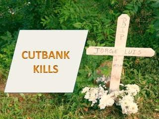
Cutbank Kills: Point Bar or Cut Bank? Depositional Processes
- 2. This is very sad. A mineral owner drowned in the river. But -‐-‐ was it an accident or a murder? Here's a temporary marker near where they pulled him out. How horrible.
- 3. He had just leased his land containing thick, briAle, highly fracable Woodford shale for $2 million. He also liked noodling for caFish in the river whenever they opened up the floodgates.
- 4. Oh no. The river was in flood! If he did not understand how rivers flow -‐ how they deposit sand, and also erode, then he could have been in trouble. I think he was murdered for his money!
- 5. Check it out. He thought it was a point bar, but it was a cutbank. Point bars are good for wading. Ah yes! A point bar is where sand is deposited. It makes nice river banks and mini-‐ beaches.
- 6. Key Points: • First • Second • Third • Etc This is what it is …
- 7. Three young guys drowned noodling for caFish. The stepped off a cutbank and then the current swept them into some bushes. They were trapped under water. The deep water is where the caFish like to forage for food.
- 8. I think he might have thought he was on the point bar, but the river was in flood, and it changed course. That is what happens. So a point bar became a cut bank? That is scary. Yes! and it is very scary... respect fluvial systems, but especially when they are in flood.
- 9. Yes! This is a great moment to look at sedimentary systems. Ancient point bars make great traps for oil. Also, it is why sand deposits are so tricky to map. Great! Let's review and see what we learn!
- 10. DedicaSon to Jorge Luis