SlideShare a Scribd company logo
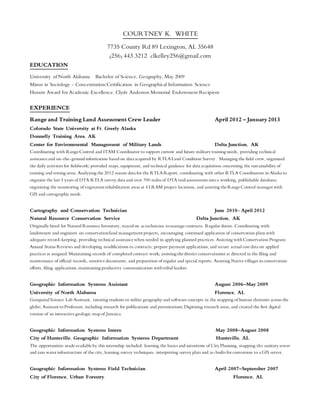
COURTNEY K. WHITE
7735 County Rd 89 Lexington, AL 35648
(256) 443.3212 clkelley256@gmail.com
EDUCATION
University of North Alabama Bachelor of Science, Geography, May 2009
Minor in Sociology - Concentration/Certification in Geographical Information Science
Honors Award for Academic Excellence, Clyde Anderson Memorial Endowment Recipient
EXPERIENCE
Range and Training Land Assessment Crew Leader April 2012 – January2013
Colorado State University at Ft. Greely Alaska
Donnelly Training Area, AK
Center for Environmental Management of Military Lands Delta Junction, AK
Coordinating with RangeControl and ITAM Coordinator to support current and future military training needs, providing technical
assistanceand on-the-ground information based on data acquired by RTLA Land Condition Survey. Managing the field crew, organized
the daily activities for fieldwork; provided maps,equipment, and technical guidance for data acquisition concerning the sustainability of
training and testing areas.Analyzing the 2012 season data for the RTLA Report, coordinating with other RTLA Coordinators in Alaska to
organize the last 3 years of DTA RTLA survey data and over 700 miles of DTA trail assessments intoa working, publishable database;
organizing the monitoring of vegetationrehabilitation areas at 4 LRAM project locations, and assisting theRangeControl manager with
GIS and cartographic needs.
Cartography and Conservation Technician June 2010- April 2012
Natural Resource Conservation Service Delta Junction, AK
Originally hired for Natural Resource Inventory, stayed on as technician tomanage contracts. Regular duties: Coordinating with
landowners and engineers on conservation/land management projects, encouraging continued application of conservation plans with
adequate record-keeping, providing technical assistancewhen needed in applying planned practices. Assisting withConservation Program
Annual Status Reviews and developing modifications to contracts, prepare payment applications,and secure actual cost data on applied
practices as assigned.Maintaining records of completed contract work; assisting thedistrict conservationist as directed in the filing and
maintenance of official records, sensitivedocuments, and preparation of regular and special reports. Assisting Nativevillages inconservation
efforts, filing applications,maintaining productive communication withtribal leaders.
Geographic Information Systems Assistant August 2006–May 2009
University of North Alabama Florence, AL
Geospatial Science Lab Assistant, tutoring students to utilize geography and softwareconcepts in the mapping of human elements across the
globe; Assistant toProfessors, including research for publications and presentations; Digitizing research areas,and created the first digital
version of an interactivegeologic map of Jamaica.
Geographic Information Systems Intern May 2008–August 2008
City of Huntsville, Geographic Information Systems Department Huntsville, AL
The opportunities madeavailableby this internship included: learning the basics and intentions of City Planning, mapping the sanitary sewer
and rain water infrastructure of the city,learning survey techniques, interpreting survey plats and as-builts for conversion to a GIS server.
Geographic Information Systems Field Technician April 2007–September 2007
City of Florence, Urban Forestry Florence, AL
Worked with a crew of 4 other geographers in order to conduct a Tree Inventory. The goal of this project was tocollect point data, and
attributethe taxonomy,size and agefor 35,000 trees located in the city rights-of-way toestablishFlorence, AL as a Tree City,USA.
Volunteer Student Internship January 2006–May 2006
Natural Resource Conservation Service Florence, AL
Assisted Soil Conservationists and District Conservationist in collecting data for conservation contracts and stream bank reclamations.
Conducted outreach for school-age community education.
SKILLS / TRAINING
Relevant Coursework: Certification in GeoSpatial Information Systems, Advanced Digital Applications in Geographic Information Science,
RemoteSensing, Introductory GIS, Use and Interpretationof Aerial Photos and SatelliteImages,Cartography,Map Interpretation, Physical
Geology, Regional Geographies of Africa and The Middle East, Nature& Society Interactions, Economic Geography, Bio-
Geography/Ecology. Bear Safety Course and Shotgun Training, ATV safety training, First Aid and CPR Certification, AgLearn
Conservation/Natural Resources training courses (as required by USDA).
Software: Protracts,Fund Manager, Toolkit, ERDAS Imagine, ArcGIS 10.x, DNR Garmin, Microsoft Office Suite, Adobe Photoshop &
Illustrator,DataPlus Professional
Projects: Landfill Site Analysis & Proposal, Land Use/Land Cover Change & Flood Analysis; Rural Middle Eastern Site Analysis Before &
After Earthquake; Tsunami Destruction Analysis; Stream ReachInventory and Order Analysis; Critical/Hazardous Area mapping; Data
Collection and Mapping of Hurricane Katrina Recovery Processes & Progress in Gulf Port/Biloxi/Bay Saint Louis, Mississippi; GIS and
demographic analysis for New Retail Chain Development; DatabaseBuilding/Management; Range Extent and Niche Loss for Endangered
Species; Jamaica Geologic feature Mapping and Analysis of Microfossil Species Collection Areas; Pond survey assistant toNRCS Engineers;
Critical Area Planting data collection/mapping; HighTunnel, nutrient management and pest management plan implementationassistance;
Moose and grouse population and habitat surveys; RTLA Land Condition assessment and report for 2011, RTLA crew leader for data
collection 2012.
Co-Founder, Vice President, and volunteer of theTears of Love Foundation, a non-profit charitable foundation focused on helping
children who experience the sudden loss of a parent. Produced a concert and silent auction that brought over $4000.00 for the charity in
2014.

More Related Content

What's hot

Remot sensing
Remot sensingRemot sensing
Remot sensing
RJRANJEET1
 
Gis fandamentals -1
Gis fandamentals -1Gis fandamentals -1
Gis fandamentals -1
RJRANJEET1
 
Gis basic-2
Gis basic-2Gis basic-2
Gis basic-2
RJRANJEET1
 
Geographic information system(GIS) and its applications in agriculture
Geographic information system(GIS) and its applications in agricultureGeographic information system(GIS) and its applications in agriculture
Geographic information system(GIS) and its applications in agriculture
Kiranmai nalla
 
Geographic Information Systems in Archaeological Survey
Geographic Information Systems in Archaeological SurveyGeographic Information Systems in Archaeological Survey
Geographic Information Systems in Archaeological SurveyTim Weitzel
 
Applications of remote sensing and gis
Applications of remote sensing and gisApplications of remote sensing and gis
Applications of remote sensing and gis
Muralikrishnan143
 
GIS & Conservation
GIS & ConservationGIS & Conservation
GIS & Conservation
Rabail Urooj
 
ForksGIS - Continuing to Grow
ForksGIS - Continuing to GrowForksGIS - Continuing to Grow
ForksGIS - Continuing to Grow
fireflytza
 
Geographic information system – an introduction
Geographic information system – an introductionGeographic information system – an introduction
Nhst 11 surat, Application of RS & GIS in urban waste management
Nhst 11 surat,  Application of RS  & GIS in urban waste managementNhst 11 surat,  Application of RS  & GIS in urban waste management
Nhst 11 surat, Application of RS & GIS in urban waste management
Samirsinh Parmar
 
What Is GIS?
What Is GIS?What Is GIS?
What Is GIS?
Allan Laframboise
 
MIS 08 Geographical Information System
MIS 08  Geographical Information SystemMIS 08  Geographical Information System
MIS 08 Geographical Information System
Tushar B Kute
 
Application of GIS
Application of GISApplication of GIS
Application of GIS
Rohit Pant
 
Geoinformatics 2019
Geoinformatics 2019Geoinformatics 2019
Geoinformatics 2019
Nivetha srinivasan
 
Evaluation of Groundwater Resource Potential using GIS and Remote Sensing App...
Evaluation of Groundwater Resource Potential using GIS and Remote Sensing App...Evaluation of Groundwater Resource Potential using GIS and Remote Sensing App...
Evaluation of Groundwater Resource Potential using GIS and Remote Sensing App...
IJERA Editor
 
The Application of GIS in Urban Planning
The Application of GIS in Urban PlanningThe Application of GIS in Urban Planning
The Application of GIS in Urban Planning
agungwah
 
Gis Application
Gis ApplicationGis Application
Gis Application
Rishabh Gupta
 
GIS Data Availability in Bangladesh_Final
GIS Data Availability in Bangladesh_FinalGIS Data Availability in Bangladesh_Final
GIS Data Availability in Bangladesh_FinalRazimulseye
 

What's hot (20)

Remot sensing
Remot sensingRemot sensing
Remot sensing
 
Gis fandamentals -1
Gis fandamentals -1Gis fandamentals -1
Gis fandamentals -1
 
Gis basic-2
Gis basic-2Gis basic-2
Gis basic-2
 
Geographic information system(GIS) and its applications in agriculture
Geographic information system(GIS) and its applications in agricultureGeographic information system(GIS) and its applications in agriculture
Geographic information system(GIS) and its applications in agriculture
 
Geographic Information Systems in Archaeological Survey
Geographic Information Systems in Archaeological SurveyGeographic Information Systems in Archaeological Survey
Geographic Information Systems in Archaeological Survey
 
Resume
ResumeResume
Resume
 
Applications of remote sensing and gis
Applications of remote sensing and gisApplications of remote sensing and gis
Applications of remote sensing and gis
 
GIS & Conservation
GIS & ConservationGIS & Conservation
GIS & Conservation
 
ForksGIS - Continuing to Grow
ForksGIS - Continuing to GrowForksGIS - Continuing to Grow
ForksGIS - Continuing to Grow
 
Geographic information system – an introduction
Geographic information system – an introductionGeographic information system – an introduction
Geographic information system – an introduction
 
Nhst 11 surat, Application of RS & GIS in urban waste management
Nhst 11 surat,  Application of RS  & GIS in urban waste managementNhst 11 surat,  Application of RS  & GIS in urban waste management
Nhst 11 surat, Application of RS & GIS in urban waste management
 
What Is GIS?
What Is GIS?What Is GIS?
What Is GIS?
 
MIS 08 Geographical Information System
MIS 08  Geographical Information SystemMIS 08  Geographical Information System
MIS 08 Geographical Information System
 
Application of GIS
Application of GISApplication of GIS
Application of GIS
 
Wesley_Lienemann_Resume
Wesley_Lienemann_ResumeWesley_Lienemann_Resume
Wesley_Lienemann_Resume
 
Geoinformatics 2019
Geoinformatics 2019Geoinformatics 2019
Geoinformatics 2019
 
Evaluation of Groundwater Resource Potential using GIS and Remote Sensing App...
Evaluation of Groundwater Resource Potential using GIS and Remote Sensing App...Evaluation of Groundwater Resource Potential using GIS and Remote Sensing App...
Evaluation of Groundwater Resource Potential using GIS and Remote Sensing App...
 
The Application of GIS in Urban Planning
The Application of GIS in Urban PlanningThe Application of GIS in Urban Planning
The Application of GIS in Urban Planning
 
Gis Application
Gis ApplicationGis Application
Gis Application
 
GIS Data Availability in Bangladesh_Final
GIS Data Availability in Bangladesh_FinalGIS Data Availability in Bangladesh_Final
GIS Data Availability in Bangladesh_Final
 

Viewers also liked

Bus 510 week 4 assignment 2 – drafting a basic proposal – strayer latest
Bus 510 week 4 assignment 2 – drafting a basic proposal – strayer latestBus 510 week 4 assignment 2 – drafting a basic proposal – strayer latest
Bus 510 week 4 assignment 2 – drafting a basic proposal – strayer latest
Homework Help Online
 
Olivia Martin Resume
Olivia Martin Resume Olivia Martin Resume
Olivia Martin Resume
Olivia Martin
 
Resume 2015- Revised2_Abby_Heflin
Resume 2015- Revised2_Abby_HeflinResume 2015- Revised2_Abby_Heflin
Resume 2015- Revised2_Abby_HeflinAbby Heflin
 
Kayla Bartz_Curriculum Vitae_2016 (1)
Kayla Bartz_Curriculum Vitae_2016 (1)Kayla Bartz_Curriculum Vitae_2016 (1)
Kayla Bartz_Curriculum Vitae_2016 (1)Kayla Bartz
 
Christina Palmer Resume 2016
Christina Palmer Resume 2016Christina Palmer Resume 2016
Christina Palmer Resume 2016Christina Palmer
 
OT 630_Final Resume_Selsted-Sianez
OT 630_Final Resume_Selsted-SianezOT 630_Final Resume_Selsted-Sianez
OT 630_Final Resume_Selsted-SianezAshley Sianez
 
Creola J. Swift-Macklin Resume
Creola J. Swift-Macklin ResumeCreola J. Swift-Macklin Resume
Creola J. Swift-Macklin ResumeCreola Macklin
 

Viewers also liked (17)

Bus 510 week 4 assignment 2 – drafting a basic proposal – strayer latest
Bus 510 week 4 assignment 2 – drafting a basic proposal – strayer latestBus 510 week 4 assignment 2 – drafting a basic proposal – strayer latest
Bus 510 week 4 assignment 2 – drafting a basic proposal – strayer latest
 
Olivia Martin Resume
Olivia Martin Resume Olivia Martin Resume
Olivia Martin Resume
 
Resume 2015- Revised2_Abby_Heflin
Resume 2015- Revised2_Abby_HeflinResume 2015- Revised2_Abby_Heflin
Resume 2015- Revised2_Abby_Heflin
 
Resume MAY 2016
Resume MAY 2016Resume MAY 2016
Resume MAY 2016
 
Mera Resume
Mera ResumeMera Resume
Mera Resume
 
KB_Resume_2015
KB_Resume_2015KB_Resume_2015
KB_Resume_2015
 
CV 2016
CV 2016CV 2016
CV 2016
 
DCW Resume
DCW ResumeDCW Resume
DCW Resume
 
RESUME PDF
RESUME PDFRESUME PDF
RESUME PDF
 
Kayla Bartz_Curriculum Vitae_2016 (1)
Kayla Bartz_Curriculum Vitae_2016 (1)Kayla Bartz_Curriculum Vitae_2016 (1)
Kayla Bartz_Curriculum Vitae_2016 (1)
 
Curriculum Vitae - RParks 06.2016
Curriculum Vitae - RParks 06.2016Curriculum Vitae - RParks 06.2016
Curriculum Vitae - RParks 06.2016
 
Champagne Resume - LinkedIn
Champagne Resume - LinkedInChampagne Resume - LinkedIn
Champagne Resume - LinkedIn
 
Christina Palmer Resume 2016
Christina Palmer Resume 2016Christina Palmer Resume 2016
Christina Palmer Resume 2016
 
PT resume
PT resumePT resume
PT resume
 
OT 630_Final Resume_Selsted-Sianez
OT 630_Final Resume_Selsted-SianezOT 630_Final Resume_Selsted-Sianez
OT 630_Final Resume_Selsted-Sianez
 
CV
CVCV
CV
 
Creola J. Swift-Macklin Resume
Creola J. Swift-Macklin ResumeCreola J. Swift-Macklin Resume
Creola J. Swift-Macklin Resume
 

Similar to CSresume1_edits[1]

Resume
ResumeResume
Resumejcure
 
Szelak_Nicholas_Resume_Blog
Szelak_Nicholas_Resume_BlogSzelak_Nicholas_Resume_Blog
Szelak_Nicholas_Resume_BlogNicholas Szelak
 
CORE COMPETENCIES
CORE COMPETENCIESCORE COMPETENCIES
CORE COMPETENCIESAna Abante
 
Copy of Olga Rybakov Resume 2
Copy of Olga Rybakov Resume 2Copy of Olga Rybakov Resume 2
Copy of Olga Rybakov Resume 2Olena Rybakov
 
2015A_Gonzales.JannelResume
2015A_Gonzales.JannelResume2015A_Gonzales.JannelResume
2015A_Gonzales.JannelResumeJannel Gonzales
 
2015TR_Gonzales.JannelResume
2015TR_Gonzales.JannelResume2015TR_Gonzales.JannelResume
2015TR_Gonzales.JannelResumeJannel Gonzales
 
Resume Stephen Kuhlman 05 17 2012 EP
Resume Stephen Kuhlman 05 17 2012 EPResume Stephen Kuhlman 05 17 2012 EP
Resume Stephen Kuhlman 05 17 2012 EPskuhlman
 
Empowering institutions and stakeholders for spatial planning - Dr. Nagaraj R...
Empowering institutions and stakeholders for spatial planning - Dr. Nagaraj R...Empowering institutions and stakeholders for spatial planning - Dr. Nagaraj R...
Empowering institutions and stakeholders for spatial planning - Dr. Nagaraj R...
NeGD Capacity Building
 

Similar to CSresume1_edits[1] (20)

KA_Rsm_June2016
KA_Rsm_June2016KA_Rsm_June2016
KA_Rsm_June2016
 
Resume for Web
Resume for WebResume for Web
Resume for Web
 
Adams Resume
Adams ResumeAdams Resume
Adams Resume
 
FINAL REPORT
FINAL REPORTFINAL REPORT
FINAL REPORT
 
Resume
ResumeResume
Resume
 
Smart_vita
Smart_vitaSmart_vita
Smart_vita
 
Szelak_Nicholas_Resume_Blog
Szelak_Nicholas_Resume_BlogSzelak_Nicholas_Resume_Blog
Szelak_Nicholas_Resume_Blog
 
CORE COMPETENCIES
CORE COMPETENCIESCORE COMPETENCIES
CORE COMPETENCIES
 
tgfallis_resume
tgfallis_resumetgfallis_resume
tgfallis_resume
 
Resume - James A Blumenschein
Resume - James A BlumenscheinResume - James A Blumenschein
Resume - James A Blumenschein
 
Copy of Olga Rybakov Resume 2
Copy of Olga Rybakov Resume 2Copy of Olga Rybakov Resume 2
Copy of Olga Rybakov Resume 2
 
Resume
ResumeResume
Resume
 
2015A_Gonzales.JannelResume
2015A_Gonzales.JannelResume2015A_Gonzales.JannelResume
2015A_Gonzales.JannelResume
 
2015TR_Gonzales.JannelResume
2015TR_Gonzales.JannelResume2015TR_Gonzales.JannelResume
2015TR_Gonzales.JannelResume
 
ERoycraft_GIS_portfolio
ERoycraft_GIS_portfolioERoycraft_GIS_portfolio
ERoycraft_GIS_portfolio
 
Resume Stephen Kuhlman 05 17 2012 EP
Resume Stephen Kuhlman 05 17 2012 EPResume Stephen Kuhlman 05 17 2012 EP
Resume Stephen Kuhlman 05 17 2012 EP
 
MDE_Projects_history_2016
MDE_Projects_history_2016MDE_Projects_history_2016
MDE_Projects_history_2016
 
Empowering institutions and stakeholders for spatial planning - Dr. Nagaraj R...
Empowering institutions and stakeholders for spatial planning - Dr. Nagaraj R...Empowering institutions and stakeholders for spatial planning - Dr. Nagaraj R...
Empowering institutions and stakeholders for spatial planning - Dr. Nagaraj R...
 
Doescher_Resume
Doescher_ResumeDoescher_Resume
Doescher_Resume
 
Curriculum Vitae15-Horneman EXPANDED _20151124_
Curriculum Vitae15-Horneman EXPANDED _20151124_Curriculum Vitae15-Horneman EXPANDED _20151124_
Curriculum Vitae15-Horneman EXPANDED _20151124_
 

CSresume1_edits[1]

  • 1. COURTNEY K. WHITE 7735 County Rd 89 Lexington, AL 35648 (256) 443.3212 clkelley256@gmail.com EDUCATION University of North Alabama Bachelor of Science, Geography, May 2009 Minor in Sociology - Concentration/Certification in Geographical Information Science Honors Award for Academic Excellence, Clyde Anderson Memorial Endowment Recipient EXPERIENCE Range and Training Land Assessment Crew Leader April 2012 – January2013 Colorado State University at Ft. Greely Alaska Donnelly Training Area, AK Center for Environmental Management of Military Lands Delta Junction, AK Coordinating with RangeControl and ITAM Coordinator to support current and future military training needs, providing technical assistanceand on-the-ground information based on data acquired by RTLA Land Condition Survey. Managing the field crew, organized the daily activities for fieldwork; provided maps,equipment, and technical guidance for data acquisition concerning the sustainability of training and testing areas.Analyzing the 2012 season data for the RTLA Report, coordinating with other RTLA Coordinators in Alaska to organize the last 3 years of DTA RTLA survey data and over 700 miles of DTA trail assessments intoa working, publishable database; organizing the monitoring of vegetationrehabilitation areas at 4 LRAM project locations, and assisting theRangeControl manager with GIS and cartographic needs. Cartography and Conservation Technician June 2010- April 2012 Natural Resource Conservation Service Delta Junction, AK Originally hired for Natural Resource Inventory, stayed on as technician tomanage contracts. Regular duties: Coordinating with landowners and engineers on conservation/land management projects, encouraging continued application of conservation plans with adequate record-keeping, providing technical assistancewhen needed in applying planned practices. Assisting withConservation Program Annual Status Reviews and developing modifications to contracts, prepare payment applications,and secure actual cost data on applied practices as assigned.Maintaining records of completed contract work; assisting thedistrict conservationist as directed in the filing and maintenance of official records, sensitivedocuments, and preparation of regular and special reports. Assisting Nativevillages inconservation efforts, filing applications,maintaining productive communication withtribal leaders. Geographic Information Systems Assistant August 2006–May 2009 University of North Alabama Florence, AL Geospatial Science Lab Assistant, tutoring students to utilize geography and softwareconcepts in the mapping of human elements across the globe; Assistant toProfessors, including research for publications and presentations; Digitizing research areas,and created the first digital version of an interactivegeologic map of Jamaica. Geographic Information Systems Intern May 2008–August 2008 City of Huntsville, Geographic Information Systems Department Huntsville, AL The opportunities madeavailableby this internship included: learning the basics and intentions of City Planning, mapping the sanitary sewer and rain water infrastructure of the city,learning survey techniques, interpreting survey plats and as-builts for conversion to a GIS server. Geographic Information Systems Field Technician April 2007–September 2007 City of Florence, Urban Forestry Florence, AL
  • 2. Worked with a crew of 4 other geographers in order to conduct a Tree Inventory. The goal of this project was tocollect point data, and attributethe taxonomy,size and agefor 35,000 trees located in the city rights-of-way toestablishFlorence, AL as a Tree City,USA. Volunteer Student Internship January 2006–May 2006 Natural Resource Conservation Service Florence, AL Assisted Soil Conservationists and District Conservationist in collecting data for conservation contracts and stream bank reclamations. Conducted outreach for school-age community education. SKILLS / TRAINING Relevant Coursework: Certification in GeoSpatial Information Systems, Advanced Digital Applications in Geographic Information Science, RemoteSensing, Introductory GIS, Use and Interpretationof Aerial Photos and SatelliteImages,Cartography,Map Interpretation, Physical Geology, Regional Geographies of Africa and The Middle East, Nature& Society Interactions, Economic Geography, Bio- Geography/Ecology. Bear Safety Course and Shotgun Training, ATV safety training, First Aid and CPR Certification, AgLearn Conservation/Natural Resources training courses (as required by USDA). Software: Protracts,Fund Manager, Toolkit, ERDAS Imagine, ArcGIS 10.x, DNR Garmin, Microsoft Office Suite, Adobe Photoshop & Illustrator,DataPlus Professional Projects: Landfill Site Analysis & Proposal, Land Use/Land Cover Change & Flood Analysis; Rural Middle Eastern Site Analysis Before & After Earthquake; Tsunami Destruction Analysis; Stream ReachInventory and Order Analysis; Critical/Hazardous Area mapping; Data Collection and Mapping of Hurricane Katrina Recovery Processes & Progress in Gulf Port/Biloxi/Bay Saint Louis, Mississippi; GIS and demographic analysis for New Retail Chain Development; DatabaseBuilding/Management; Range Extent and Niche Loss for Endangered Species; Jamaica Geologic feature Mapping and Analysis of Microfossil Species Collection Areas; Pond survey assistant toNRCS Engineers; Critical Area Planting data collection/mapping; HighTunnel, nutrient management and pest management plan implementationassistance; Moose and grouse population and habitat surveys; RTLA Land Condition assessment and report for 2011, RTLA crew leader for data collection 2012. Co-Founder, Vice President, and volunteer of theTears of Love Foundation, a non-profit charitable foundation focused on helping children who experience the sudden loss of a parent. Produced a concert and silent auction that brought over $4000.00 for the charity in 2014.