Classification of zoogeographical regions
•Download as PPTX, PDF•
1 like•1,209 views
zoogeographical regions fromation and how classification of earth takes place in last years , differnet division of zoogeographical regions in world ,
Report
Share
Report
Share

Recommended
Nearctic
The Nearctic region includes North America north of Mexico, as well as Greenland and the Aleutian Islands. It has a climate and vegetation most similar to the Palearctic region. Mammals in the Nearctic include both families shared with the Palearctic and endemic families like pocket gophers, pocket mice, sewellel, and pronghorns. Reptiles include snakes like garter snakes and rattlesnakes as well as lizards. The region also contains a diverse array of birds, fish, amphibians. While sharing similarities with the Palearctic, the Nearctic has a more distinct fauna with more endemic families and is a transition zone between temperate and tropical regions.
Wallace's Zoogeographical Realms
A zoogeographical region/realm is a sub-division of the Earth having a unique fauna, i.e. species that are found only in that area. Alfred Russel Wallace introduced six zoogeographical realms: Palearctic, Ethiopian, Oriental, Australian, Neotropical, and Nearctic regions. This is a brief overview of each.
Palearctic region by Tassanam Naz
palearctic region
geograohical range
physical features
climate
zoological charcters
mammals
birds
reptiles
amphibians
affinities of region
The zoogeographical region
1. The document discusses the distribution of various geographical regions from a zoogeographical perspective, beginning with the first distribution by Dr. P.L. Sclater in 1857 and subsequent distributions by Huxley in 1868 and Alfred Russel Wallace in 1876.
2. It provides details on the faunal composition and characteristics of key regions including the Palaearctic, Oriental, Ethiopian, Australian, Neotropical, and Nearctic regions. Each region is defined by its physical features, climate, and unique endemic families of mammals, birds, reptiles, amphibians, and other fauna.
3. The document analyzes similarities and differences in fauna between regions, with the Australian region noted as
Nearctic region
The Nearctic region includes North America north of the Tropic of Cancer, including Newfoundland, the Arctic Archipelago, and Greenland. This region is known for its diversity of salamanders and is considered the "headquarters of urodels". When North and South America joined through the Isthmus of Panama 3 million years ago, many animal species migrated between the continents. Animals from the north like llamas, tapirs, and pumas moved into South America, while armadillos, opossums, and porcupines moved northward. The Nearctic region shows great climatic variation from frozen ice sheets in Greenland to deserts in western North America. It contains several distinct sub-regions
Australian region
The document summarizes the key characteristics of the fauna found in the Australasian region, which includes Australia, New Zealand, New Guinea, and nearby islands. Some key points:
- The region has a thin diversity of vertebrate species and lacks many families found elsewhere. However, it contains many unique genera.
- Marsupials and monotremes are only found in this region. Common mammals like rabbits have been introduced.
- Birds are abundant with many unique families like cassowaries, emus, and birds of paradise.
- Reptiles include crocodiles, turtles, geckos, and snakes. Amphibians are few and do not include toads
Palaearctic region
The Palearctic region is one of the eight biogeographic realms of the Earth. It includes Europe, northern Africa, northern China, Russia, Japan, Iran, Afghanistan, and western Pakistan. The climate is mostly temperate, with both forested and open steppe lands. Zoologically, the region contains many families of mammals like rabbits, hedgehogs, and deer. It also has over 50 families of migratory birds but no parrots. Reptiles include turtles, tortoises, lizards and snakes. Amphibians prominently feature newts and salamanders. Fish include carps, salmon, and eels, with carp being dominant.
introduction to zoogeography
this video is about introduction to zoo geography, its history and branches of zoo geography . follow up categories are Bs zoology, and MSC zoology
ZOOGEOGRAPHY
Zoogeographers formulate theories to explain the distribution, based on information about geography, physiography, climate, and geologic history, as well as knowledge of the evolutionary history and relationships of the animals involved
Zoogeography and factors affecting animal distribution
This document discusses zoogeography and the factors affecting animal distribution. It begins by defining zoogeography and describing the three levels at which distribution can be studied. It then outlines the six main zoogeographic regions identified by Sclater and Wallace: Palearctic, Nearctic, Neotropical, Ethiopian, Oriental, and Australian. For each region, it provides details on location, climate, vegetation, fauna, and subdivisions. It also discusses patterns of animal distribution and the barriers and means of dispersal that influence distribution patterns.
Animal distribution
This document discusses principles of animal distribution and barriers to animal distribution. It outlines several laws and principles that govern how animals are distributed, including that animals are generally found where they are best adapted, and barriers like oceans can prevent distribution to new areas. Barriers to distribution are categorized as extrinsic, like physical geographic barriers and climate, or intrinsic, stemming from animal behaviors. Different patterns of distribution are also described, such as continuous, discontinuous, and Arctic/polar distributions.
Insular Fauna
The document summarizes insular fauna, or animal life on islands. It discusses the differences between continental islands and oceanic islands. Continental islands, like Great Britain and Japan, were once connected to mainland but are now separated by water. Their fauna is similar to the mainland. Oceanic islands, such as Galapagos and Krakatoa, have never been connected and have unique fauna adapted to island conditions, often with flightless birds and giant reptiles. It also describes the ancient islands of New Zealand and Madagascar, which have relic species and a high proportion of endemic fauna.
Insular fauna
1) The document discusses the fauna of various insular regions including continental islands like the British Isles and Japan, oceanic islands like the Galapagos and Krakatau, and ancient islands like Madagascar and New Zealand.
2) It describes how the fauna of continental islands is similar to nearby mainland regions, while oceanic islands have less diverse and endemic fauna due to their isolation.
3) Madagascar is highlighted as an ancient island with many unique families of lemurs, birds, and reptiles found only there.
Animal distribution
Dr. Shoeb Ahmad, Assistant Professor, Department of Zoology, AKI's Poona College of Arts, Science and Commerce, Camp, Pune -41100, Maharashtra (INDIA)
Oriental region
The document describes the fauna found in the Oriental region, which includes South Asia, Southeast Asia, and southern China. It is divided into 4 sub-regions: the Indian, Ceylon, Indo-China, and Indo-Malayan sub-regions. Each sub-region supports different types of fauna, including various mammals, birds, reptiles, amphibians, and fish. In total, the region's fauna includes over 30 mammalian families and 66 bird families, and is dominated by species like carp, catfish, snakes, lizards, monkeys, rhinos, and elephants.
Insular Fauna
Insular (isolated) fauna is the animal biodiversity of islands. This is a brief outline of the fauna of several islands, spread throughout the world, and divided into three categories: continental islands, oceanic islands, and ancient islands.
Palaerarctic region.the zoogeographical separation and distribution of animal...
zoogeography mean that simply state that distribution of animals on the basics of geography.several zoogeography area present.palaearctic region have a special type of organisms distribution
Branches of zoogeographic .
This document provides information about the 5th semester zoology course titled "Zoogeography & Palentology" with course code Zool-543 and 3 credit hours. It defines zoogeography as the study of animal distribution over the world. The document then outlines the history and branches of zoogeography, including applied, causal, and descriptive zoogeography. The causal branch examines ecological, historical, and experimental factors influencing distribution, while the descriptive branch studies animals and habitats through systematic, chorological, and faunistic approaches.
Zoogeography
There are few places left on the planet where the impact of people has not been felt. We have explored and left our footprint on nearly every corner of the globe. As our population and needs grow, we are leaving less and less room for wildlife.
Wildlife are under threat from many different kinds of human activities, from directly destroying habitat to spreading invasive species and disease. Most ecosystems are facing multiple threats. Each new threat puts additional stress on already weakened ecosystems and their wildlife.
Animal distribution
This document discusses different types of animal distribution patterns across space and time. It describes two major kinds of distribution - spatial distribution, which is the distribution of animals across different geographical regions, and geological distribution, which is the distribution of animals over geological time as revealed by fossils. The key spatial distribution patterns discussed are geographical/horizontal distribution, bathymetric/vertical distribution, and four types based on geographical range - cosmopolitan, discontinuous, isolated, and bipolar. Examples are provided for each distribution type.
WETLANDS
Wetlands are... areas where a water table is at, near, or just above the surface
and where soils are water-saturated for a sufficient length of time such that excess
water and resulting low soil oxygen levels are principal determinants of vegetation
and soil development. wetlands will have a relative abundance of obligate
hydrophytes in the vegetation community and soils featuring “hydric” characteristics.
Ethiopian region
The document describes the Ethiopian zoogeographic region which includes parts of Africa, Arabia, and Madagascar. It notes that the region shows extensive desert in the north (Sahara Desert) and thick forests in the west. The climate varies with altitude but averages 25-35°C with rainfall from June to September averaging 510mm annually. The region is then divided into four sub-regions: East African (tropical Africa and Arabia), West African (thick forests and Congo River), South African (southern Africa with peculiar fauna), and Malagasy (Madagascar and islands with unique lemurs and chameleons).
Animal distribution zoogeo
Animals are not uniformly distributed across land and water due to factors like climate, food availability, shelter, and other species. Their distribution can be categorized as continuous, discontinuous, endemic, isolated, or bipolar. Continuous distribution means worldwide presence. Discontinuous distribution occurs when habitat is broken up, such as by oceans or changing land masses. Endemic distribution confines species to particular regions. Isolated and bipolar distributions restrict some animals only to specific isolated areas like Australia or polar regions.
Barriers to Animal Dispersal
This document discusses various types of barriers to animal dispersal. It categorizes barriers into physiological, ecological, behavioral, and artificial barriers. For marine environments, key barriers include land masses, temperature, salt concentration, and pressure. In freshwater, land masses and salt concentration pose barriers. Terrestrial barriers include mountains, deserts, large rivers, rainfall regions, oceans, and human developments like urbanization and agriculture. The effectiveness of barriers depends on both the challenges they present and characteristics of attempting to cross organisms.
Population counting method line transect, point count, mark and recapture
Line transect, point count, and mark-recapture are three common population counting methods. Line transect involves walking or flying along a straight transect line and recording sightings and their perpendicular distances. Point count involves recording all birds seen and heard from count stations for a set time period. Mark-recapture involves capturing and marking a sample of the population, releasing them, then capturing another sample to estimate the total population size based on the proportion that were marked. Each method makes assumptions about animal behavior and has advantages such as being economical or applicable throughout the year as well as disadvantages like missing rare species.
Neotropical region
The Neotropical region includes South America, Central America, Mexico, and the West Indies. It is mostly tropical and has extensive forests with no deserts. It is divided into four subregions: the Chillian subregion along the west coast of South America containing the Andes Mountains, the Brazilian subregion containing the Amazon rainforest, the Mexican subregion north of Panama with rocky mountains, and the West Indies subregion containing the Caribbean islands. The region has high biodiversity and endemism including new world monkeys, armadillos, birds like toucans and parrots, and amphibians and reptiles like caecilians and iguanas.
Evolution of elephant
1. The document traces the evolution of elephants from early proboscideans like Moeritherium and Phiomia to modern elephants.
2. Key changes during evolution included an increase in size, elongation of the nose and upper lip to form a trunk, development of tusks, and adaptation of teeth for a grazing diet.
3. Modern elephants belong to the genera Elephas and Loxodonta and are characterized by their huge size, pillar-like legs, trunk, and teeth adapted for grinding plant material.
Ethiopian region
This document summarizes the key characteristics of the Ethiopian zoogeographic region. It notes that the region includes Africa south of the Sahara, Madagascar, and southern Arabia. The climate is mainly tropical, with large forests, grasslands, and mountains. The region has a diverse vertebrate fauna, including many endemic fish, amphibians, reptiles, birds, and mammal families. Some examples of unique species mentioned are lungfish, African electric fish, chameleons, ostriches, giraffes, and hippopotamuses.
如何办理(uvic毕业证书)维多利亚大学毕业证本科学位证书原版一模一样
原版纸张【微信:741003700 】【(uvic毕业证书)维多利亚大学毕业证】【微信:741003700 】学位证,留信认证(真实可查,永久存档)offer、雅思、外壳等材料/诚信可靠,可直接看成品样本,帮您解决无法毕业带来的各种难题!外壳,原版制作,诚信可靠,可直接看成品样本。行业标杆!精益求精,诚心合作,真诚制作!多年品质 ,按需精细制作,24小时接单,全套进口原装设备。十五年致力于帮助留学生解决难题,包您满意。
本公司拥有海外各大学样板无数,能完美还原海外各大学 Bachelor Diploma degree, Master Degree Diploma
1:1完美还原海外各大学毕业材料上的工艺:水印,阴影底纹,钢印LOGO烫金烫银,LOGO烫金烫银复合重叠。文字图案浮雕、激光镭射、紫外荧光、温感、复印防伪等防伪工艺。材料咨询办理、认证咨询办理请加学历顾问Q/微741003700
留信网认证的作用:
1:该专业认证可证明留学生真实身份
2:同时对留学生所学专业登记给予评定
3:国家专业人才认证中心颁发入库证书
4:这个认证书并且可以归档倒地方
5:凡事获得留信网入网的信息将会逐步更新到个人身份内,将在公安局网内查询个人身份证信息后,同步读取人才网入库信息
6:个人职称评审加20分
7:个人信誉贷款加10分
8:在国家人才网主办的国家网络招聘大会中纳入资料,供国家高端企业选择人才
More Related Content
What's hot
ZOOGEOGRAPHY
Zoogeographers formulate theories to explain the distribution, based on information about geography, physiography, climate, and geologic history, as well as knowledge of the evolutionary history and relationships of the animals involved
Zoogeography and factors affecting animal distribution
This document discusses zoogeography and the factors affecting animal distribution. It begins by defining zoogeography and describing the three levels at which distribution can be studied. It then outlines the six main zoogeographic regions identified by Sclater and Wallace: Palearctic, Nearctic, Neotropical, Ethiopian, Oriental, and Australian. For each region, it provides details on location, climate, vegetation, fauna, and subdivisions. It also discusses patterns of animal distribution and the barriers and means of dispersal that influence distribution patterns.
Animal distribution
This document discusses principles of animal distribution and barriers to animal distribution. It outlines several laws and principles that govern how animals are distributed, including that animals are generally found where they are best adapted, and barriers like oceans can prevent distribution to new areas. Barriers to distribution are categorized as extrinsic, like physical geographic barriers and climate, or intrinsic, stemming from animal behaviors. Different patterns of distribution are also described, such as continuous, discontinuous, and Arctic/polar distributions.
Insular Fauna
The document summarizes insular fauna, or animal life on islands. It discusses the differences between continental islands and oceanic islands. Continental islands, like Great Britain and Japan, were once connected to mainland but are now separated by water. Their fauna is similar to the mainland. Oceanic islands, such as Galapagos and Krakatoa, have never been connected and have unique fauna adapted to island conditions, often with flightless birds and giant reptiles. It also describes the ancient islands of New Zealand and Madagascar, which have relic species and a high proportion of endemic fauna.
Insular fauna
1) The document discusses the fauna of various insular regions including continental islands like the British Isles and Japan, oceanic islands like the Galapagos and Krakatau, and ancient islands like Madagascar and New Zealand.
2) It describes how the fauna of continental islands is similar to nearby mainland regions, while oceanic islands have less diverse and endemic fauna due to their isolation.
3) Madagascar is highlighted as an ancient island with many unique families of lemurs, birds, and reptiles found only there.
Animal distribution
Dr. Shoeb Ahmad, Assistant Professor, Department of Zoology, AKI's Poona College of Arts, Science and Commerce, Camp, Pune -41100, Maharashtra (INDIA)
Oriental region
The document describes the fauna found in the Oriental region, which includes South Asia, Southeast Asia, and southern China. It is divided into 4 sub-regions: the Indian, Ceylon, Indo-China, and Indo-Malayan sub-regions. Each sub-region supports different types of fauna, including various mammals, birds, reptiles, amphibians, and fish. In total, the region's fauna includes over 30 mammalian families and 66 bird families, and is dominated by species like carp, catfish, snakes, lizards, monkeys, rhinos, and elephants.
Insular Fauna
Insular (isolated) fauna is the animal biodiversity of islands. This is a brief outline of the fauna of several islands, spread throughout the world, and divided into three categories: continental islands, oceanic islands, and ancient islands.
Palaerarctic region.the zoogeographical separation and distribution of animal...
zoogeography mean that simply state that distribution of animals on the basics of geography.several zoogeography area present.palaearctic region have a special type of organisms distribution
Branches of zoogeographic .
This document provides information about the 5th semester zoology course titled "Zoogeography & Palentology" with course code Zool-543 and 3 credit hours. It defines zoogeography as the study of animal distribution over the world. The document then outlines the history and branches of zoogeography, including applied, causal, and descriptive zoogeography. The causal branch examines ecological, historical, and experimental factors influencing distribution, while the descriptive branch studies animals and habitats through systematic, chorological, and faunistic approaches.
Zoogeography
There are few places left on the planet where the impact of people has not been felt. We have explored and left our footprint on nearly every corner of the globe. As our population and needs grow, we are leaving less and less room for wildlife.
Wildlife are under threat from many different kinds of human activities, from directly destroying habitat to spreading invasive species and disease. Most ecosystems are facing multiple threats. Each new threat puts additional stress on already weakened ecosystems and their wildlife.
Animal distribution
This document discusses different types of animal distribution patterns across space and time. It describes two major kinds of distribution - spatial distribution, which is the distribution of animals across different geographical regions, and geological distribution, which is the distribution of animals over geological time as revealed by fossils. The key spatial distribution patterns discussed are geographical/horizontal distribution, bathymetric/vertical distribution, and four types based on geographical range - cosmopolitan, discontinuous, isolated, and bipolar. Examples are provided for each distribution type.
WETLANDS
Wetlands are... areas where a water table is at, near, or just above the surface
and where soils are water-saturated for a sufficient length of time such that excess
water and resulting low soil oxygen levels are principal determinants of vegetation
and soil development. wetlands will have a relative abundance of obligate
hydrophytes in the vegetation community and soils featuring “hydric” characteristics.
Ethiopian region
The document describes the Ethiopian zoogeographic region which includes parts of Africa, Arabia, and Madagascar. It notes that the region shows extensive desert in the north (Sahara Desert) and thick forests in the west. The climate varies with altitude but averages 25-35°C with rainfall from June to September averaging 510mm annually. The region is then divided into four sub-regions: East African (tropical Africa and Arabia), West African (thick forests and Congo River), South African (southern Africa with peculiar fauna), and Malagasy (Madagascar and islands with unique lemurs and chameleons).
Animal distribution zoogeo
Animals are not uniformly distributed across land and water due to factors like climate, food availability, shelter, and other species. Their distribution can be categorized as continuous, discontinuous, endemic, isolated, or bipolar. Continuous distribution means worldwide presence. Discontinuous distribution occurs when habitat is broken up, such as by oceans or changing land masses. Endemic distribution confines species to particular regions. Isolated and bipolar distributions restrict some animals only to specific isolated areas like Australia or polar regions.
Barriers to Animal Dispersal
This document discusses various types of barriers to animal dispersal. It categorizes barriers into physiological, ecological, behavioral, and artificial barriers. For marine environments, key barriers include land masses, temperature, salt concentration, and pressure. In freshwater, land masses and salt concentration pose barriers. Terrestrial barriers include mountains, deserts, large rivers, rainfall regions, oceans, and human developments like urbanization and agriculture. The effectiveness of barriers depends on both the challenges they present and characteristics of attempting to cross organisms.
Population counting method line transect, point count, mark and recapture
Line transect, point count, and mark-recapture are three common population counting methods. Line transect involves walking or flying along a straight transect line and recording sightings and their perpendicular distances. Point count involves recording all birds seen and heard from count stations for a set time period. Mark-recapture involves capturing and marking a sample of the population, releasing them, then capturing another sample to estimate the total population size based on the proportion that were marked. Each method makes assumptions about animal behavior and has advantages such as being economical or applicable throughout the year as well as disadvantages like missing rare species.
Neotropical region
The Neotropical region includes South America, Central America, Mexico, and the West Indies. It is mostly tropical and has extensive forests with no deserts. It is divided into four subregions: the Chillian subregion along the west coast of South America containing the Andes Mountains, the Brazilian subregion containing the Amazon rainforest, the Mexican subregion north of Panama with rocky mountains, and the West Indies subregion containing the Caribbean islands. The region has high biodiversity and endemism including new world monkeys, armadillos, birds like toucans and parrots, and amphibians and reptiles like caecilians and iguanas.
Evolution of elephant
1. The document traces the evolution of elephants from early proboscideans like Moeritherium and Phiomia to modern elephants.
2. Key changes during evolution included an increase in size, elongation of the nose and upper lip to form a trunk, development of tusks, and adaptation of teeth for a grazing diet.
3. Modern elephants belong to the genera Elephas and Loxodonta and are characterized by their huge size, pillar-like legs, trunk, and teeth adapted for grinding plant material.
Ethiopian region
This document summarizes the key characteristics of the Ethiopian zoogeographic region. It notes that the region includes Africa south of the Sahara, Madagascar, and southern Arabia. The climate is mainly tropical, with large forests, grasslands, and mountains. The region has a diverse vertebrate fauna, including many endemic fish, amphibians, reptiles, birds, and mammal families. Some examples of unique species mentioned are lungfish, African electric fish, chameleons, ostriches, giraffes, and hippopotamuses.
What's hot (20)
Zoogeography and factors affecting animal distribution
Zoogeography and factors affecting animal distribution
Palaerarctic region.the zoogeographical separation and distribution of animal...
Palaerarctic region.the zoogeographical separation and distribution of animal...
Population counting method line transect, point count, mark and recapture
Population counting method line transect, point count, mark and recapture
Recently uploaded
如何办理(uvic毕业证书)维多利亚大学毕业证本科学位证书原版一模一样
原版纸张【微信:741003700 】【(uvic毕业证书)维多利亚大学毕业证】【微信:741003700 】学位证,留信认证(真实可查,永久存档)offer、雅思、外壳等材料/诚信可靠,可直接看成品样本,帮您解决无法毕业带来的各种难题!外壳,原版制作,诚信可靠,可直接看成品样本。行业标杆!精益求精,诚心合作,真诚制作!多年品质 ,按需精细制作,24小时接单,全套进口原装设备。十五年致力于帮助留学生解决难题,包您满意。
本公司拥有海外各大学样板无数,能完美还原海外各大学 Bachelor Diploma degree, Master Degree Diploma
1:1完美还原海外各大学毕业材料上的工艺:水印,阴影底纹,钢印LOGO烫金烫银,LOGO烫金烫银复合重叠。文字图案浮雕、激光镭射、紫外荧光、温感、复印防伪等防伪工艺。材料咨询办理、认证咨询办理请加学历顾问Q/微741003700
留信网认证的作用:
1:该专业认证可证明留学生真实身份
2:同时对留学生所学专业登记给予评定
3:国家专业人才认证中心颁发入库证书
4:这个认证书并且可以归档倒地方
5:凡事获得留信网入网的信息将会逐步更新到个人身份内,将在公安局网内查询个人身份证信息后,同步读取人才网入库信息
6:个人职称评审加20分
7:个人信誉贷款加10分
8:在国家人才网主办的国家网络招聘大会中纳入资料,供国家高端企业选择人才
Equivariant neural networks and representation theory
Or: Beyond linear.
Abstract: Equivariant neural networks are neural networks that incorporate symmetries. The nonlinear activation functions in these networks result in interesting nonlinear equivariant maps between simple representations, and motivate the key player of this talk: piecewise linear representation theory.
Disclaimer: No one is perfect, so please mind that there might be mistakes and typos.
dtubbenhauer@gmail.com
Corrected slides: dtubbenhauer.com/talks.html
Deep Software Variability and Frictionless Reproducibility
Deep Software Variability and Frictionless ReproducibilityUniversity of Rennes, INSA Rennes, Inria/IRISA, CNRS
The ability to recreate computational results with minimal effort and actionable metrics provides a solid foundation for scientific research and software development. When people can replicate an analysis at the touch of a button using open-source software, open data, and methods to assess and compare proposals, it significantly eases verification of results, engagement with a diverse range of contributors, and progress. However, we have yet to fully achieve this; there are still many sociotechnical frictions.
Inspired by David Donoho's vision, this talk aims to revisit the three crucial pillars of frictionless reproducibility (data sharing, code sharing, and competitive challenges) with the perspective of deep software variability.
Our observation is that multiple layers — hardware, operating systems, third-party libraries, software versions, input data, compile-time options, and parameters — are subject to variability that exacerbates frictions but is also essential for achieving robust, generalizable results and fostering innovation. I will first review the literature, providing evidence of how the complex variability interactions across these layers affect qualitative and quantitative software properties, thereby complicating the reproduction and replication of scientific studies in various fields.
I will then present some software engineering and AI techniques that can support the strategic exploration of variability spaces. These include the use of abstractions and models (e.g., feature models), sampling strategies (e.g., uniform, random), cost-effective measurements (e.g., incremental build of software configurations), and dimensionality reduction methods (e.g., transfer learning, feature selection, software debloating).
I will finally argue that deep variability is both the problem and solution of frictionless reproducibility, calling the software science community to develop new methods and tools to manage variability and foster reproducibility in software systems.
Exposé invité Journées Nationales du GDR GPL 2024
Thornton ESPP slides UK WW Network 4_6_24.pdf
ESPP presentation to EU Waste Water Network, 4th June 2024 “EU policies driving nutrient removal and recycling
and the revised UWWTD (Urban Waste Water Treatment Directive)”
SAR of Medicinal Chemistry 1st by dk.pdf
In this presentation include the prototype drug SAR on thus or with their examples .
Syllabus of Second Year B. Pharmacy
2019 PATTERN.
Nucleophilic Addition of carbonyl compounds.pptx
Nucleophilic addition is the most important reaction of carbonyls. Not just aldehydes and ketones, but also carboxylic acid derivatives in general.
Carbonyls undergo addition reactions with a large range of nucleophiles.
Comparing the relative basicity of the nucleophile and the product is extremely helpful in determining how reversible the addition reaction is. Reactions with Grignards and hydrides are irreversible. Reactions with weak bases like halides and carboxylates generally don’t happen.
Electronic effects (inductive effects, electron donation) have a large impact on reactivity.
Large groups adjacent to the carbonyl will slow the rate of reaction.
Neutral nucleophiles can also add to carbonyls, although their additions are generally slower and more reversible. Acid catalysis is sometimes employed to increase the rate of addition.
Remote Sensing and Computational, Evolutionary, Supercomputing, and Intellige...
Remote Sensing and Computational, Evolutionary, Supercomputing, and Intellige...University of Maribor
Slides from talk:
Aleš Zamuda: Remote Sensing and Computational, Evolutionary, Supercomputing, and Intelligent Systems.
11th International Conference on Electrical, Electronics and Computer Engineering (IcETRAN), Niš, 3-6 June 2024
Inter-Society Networking Panel GRSS/MTT-S/CIS Panel Session: Promoting Connection and Cooperation
https://www.etran.rs/2024/en/home-english/THEMATIC APPERCEPTION TEST(TAT) cognitive abilities, creativity, and critic...
THEMATIC APPERCEPTION TEST(TAT) cognitive abilities, creativity, and critic...Abdul Wali Khan University Mardan,kP,Pakistan
hematic appreciation test is a psychological assessment tool used to measure an individual's appreciation and understanding of specific themes or topics. This test helps to evaluate an individual's ability to connect different ideas and concepts within a given theme, as well as their overall comprehension and interpretation skills. The results of the test can provide valuable insights into an individual's cognitive abilities, creativity, and critical thinking skillsMicronuclei test.M.sc.zoology.fisheries.
Current Ms word generated power point presentation covers major details about the micronuclei test. It's significance and assays to conduct it. It is used to detect the micronuclei formation inside the cells of nearly every multicellular organism. It's formation takes place during chromosomal sepration at metaphase.
20240520 Planning a Circuit Simulator in JavaScript.pptx
Evaporation step counter work. I have done a physical experiment.
(Work in progress.)
Phenomics assisted breeding in crop improvement
As the population is increasing and will reach about 9 billion upto 2050. Also due to climate change, it is difficult to meet the food requirement of such a large population. Facing the challenges presented by resource shortages, climate
change, and increasing global population, crop yield and quality need to be improved in a sustainable way over the coming decades. Genetic improvement by breeding is the best way to increase crop productivity. With the rapid progression of functional
genomics, an increasing number of crop genomes have been sequenced and dozens of genes influencing key agronomic traits have been identified. However, current genome sequence information has not been adequately exploited for understanding
the complex characteristics of multiple gene, owing to a lack of crop phenotypic data. Efficient, automatic, and accurate technologies and platforms that can capture phenotypic data that can
be linked to genomics information for crop improvement at all growth stages have become as important as genotyping. Thus,
high-throughput phenotyping has become the major bottleneck restricting crop breeding. Plant phenomics has been defined as the high-throughput, accurate acquisition and analysis of multi-dimensional phenotypes
during crop growing stages at the organism level, including the cell, tissue, organ, individual plant, plot, and field levels. With the rapid development of novel sensors, imaging technology,
and analysis methods, numerous infrastructure platforms have been developed for phenotyping.
Comparing Evolved Extractive Text Summary Scores of Bidirectional Encoder Rep...
Comparing Evolved Extractive Text Summary Scores of Bidirectional Encoder Rep...University of Maribor
Slides from:
11th International Conference on Electrical, Electronics and Computer Engineering (IcETRAN), Niš, 3-6 June 2024
Track: Artificial Intelligence
https://www.etran.rs/2024/en/home-english/Unlocking the mysteries of reproduction: Exploring fecundity and gonadosomati...
The pygmy halfbeak Dermogenys colletei, is known for its viviparous nature, this presents an intriguing case of relatively low fecundity, raising questions about potential compensatory reproductive strategies employed by this species. Our study delves into the examination of fecundity and the Gonadosomatic Index (GSI) in the Pygmy Halfbeak, D. colletei (Meisner, 2001), an intriguing viviparous fish indigenous to Sarawak, Borneo. We hypothesize that the Pygmy halfbeak, D. colletei, may exhibit unique reproductive adaptations to offset its low fecundity, thus enhancing its survival and fitness. To address this, we conducted a comprehensive study utilizing 28 mature female specimens of D. colletei, carefully measuring fecundity and GSI to shed light on the reproductive adaptations of this species. Our findings reveal that D. colletei indeed exhibits low fecundity, with a mean of 16.76 ± 2.01, and a mean GSI of 12.83 ± 1.27, providing crucial insights into the reproductive mechanisms at play in this species. These results underscore the existence of unique reproductive strategies in D. colletei, enabling its adaptation and persistence in Borneo's diverse aquatic ecosystems, and call for further ecological research to elucidate these mechanisms. This study lends to a better understanding of viviparous fish in Borneo and contributes to the broader field of aquatic ecology, enhancing our knowledge of species adaptations to unique ecological challenges.
EWOCS-I: The catalog of X-ray sources in Westerlund 1 from the Extended Weste...
Context. With a mass exceeding several 104 M⊙ and a rich and dense population of massive stars, supermassive young star clusters
represent the most massive star-forming environment that is dominated by the feedback from massive stars and gravitational interactions
among stars.
Aims. In this paper we present the Extended Westerlund 1 and 2 Open Clusters Survey (EWOCS) project, which aims to investigate
the influence of the starburst environment on the formation of stars and planets, and on the evolution of both low and high mass stars.
The primary targets of this project are Westerlund 1 and 2, the closest supermassive star clusters to the Sun.
Methods. The project is based primarily on recent observations conducted with the Chandra and JWST observatories. Specifically,
the Chandra survey of Westerlund 1 consists of 36 new ACIS-I observations, nearly co-pointed, for a total exposure time of 1 Msec.
Additionally, we included 8 archival Chandra/ACIS-S observations. This paper presents the resulting catalog of X-ray sources within
and around Westerlund 1. Sources were detected by combining various existing methods, and photon extraction and source validation
were carried out using the ACIS-Extract software.
Results. The EWOCS X-ray catalog comprises 5963 validated sources out of the 9420 initially provided to ACIS-Extract, reaching a
photon flux threshold of approximately 2 × 10⁻⁸ photons cm−2
s
−1
. The X-ray sources exhibit a highly concentrated spatial distribution,
with 1075 sources located within the central 1 arcmin. We have successfully detected X-ray emissions from 126 out of the 166 known
massive stars of the cluster, and we have collected over 71 000 photons from the magnetar CXO J164710.20-455217.
Nucleic Acid-its structural and functional complexity.
This presentation explores a brief idea about the structural and functional attributes of nucleotides, the structure and function of genetic materials along with the impact of UV rays and pH upon them.
Recently uploaded (20)
Equivariant neural networks and representation theory
Equivariant neural networks and representation theory
Deep Software Variability and Frictionless Reproducibility
Deep Software Variability and Frictionless Reproducibility
Remote Sensing and Computational, Evolutionary, Supercomputing, and Intellige...
Remote Sensing and Computational, Evolutionary, Supercomputing, and Intellige...
THEMATIC APPERCEPTION TEST(TAT) cognitive abilities, creativity, and critic...
THEMATIC APPERCEPTION TEST(TAT) cognitive abilities, creativity, and critic...
20240520 Planning a Circuit Simulator in JavaScript.pptx
20240520 Planning a Circuit Simulator in JavaScript.pptx
Comparing Evolved Extractive Text Summary Scores of Bidirectional Encoder Rep...
Comparing Evolved Extractive Text Summary Scores of Bidirectional Encoder Rep...
Unlocking the mysteries of reproduction: Exploring fecundity and gonadosomati...
Unlocking the mysteries of reproduction: Exploring fecundity and gonadosomati...
aziz sancar nobel prize winner: from mardin to nobel
aziz sancar nobel prize winner: from mardin to nobel
EWOCS-I: The catalog of X-ray sources in Westerlund 1 from the Extended Weste...
EWOCS-I: The catalog of X-ray sources in Westerlund 1 from the Extended Weste...
Nucleic Acid-its structural and functional complexity.
Nucleic Acid-its structural and functional complexity.
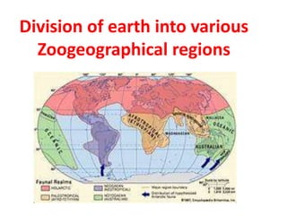
Classification of zoogeographical regions
- 1. Division of earth into various Zoogeographical regions
- 2. Classification of Zoogeographical regions • “the subdivisions of earth are called as zoogeographical regions “ • For last 75 year attempts are made up for classification of geographical region. • There are 3 major divisions for the classification of zoogeographical regions
- 3. Classification of Zoogeographical regions First division /p.l division . • DR.P.L .Sclater classify earth in 1858. Criteria :The criteria of classification is distribution of birds Scheme : He divide earth into 6- regions.these regions are
- 4. First division /p.l division Palearctic regions Indian region Ethiopian region Australian region Neotropical region Nearectic region Paleagaea regions Neogaea regions
- 5. Classification of Zoogeographical regions Second division/Huxely division • 2nd division is given by Huxely in 1868 Criteria: having no definite criteria for classification Scheme: divide earth into 2 regions and 6 sub regions .
- 6. Huxely division Arctogeaea regions Notogeaea region Palearectic region Nearectic region Ethiopian region Indian region Neotropical region Australian region NewZealand region
- 7. Classification of Zoogeographical regions Third division /wallace division Third division is given by Dr.A.R.Wallace in 187 Criteria : the criteria for classification is distribution of mammals Scheme : follow the same scheme as scalter but modified Indian region with oriental region
- 8. wallace division Palearctic regions Oriental region Ethiopian region Australian region Neotropical region Nearectic region Paleagaea regions Neogaea regions
- 9. Classification of Zoogeographical regions Fourth division Given by K.P. Schmidt in 1954 Criteria : not definite Scheme: divide earth into 3 region and 5 sub region
- 10. Fourth division Arctogaea region Notogaea region Neogaea region Holoarctic region Ethiopian region Oriental region Australian region Neotropical region