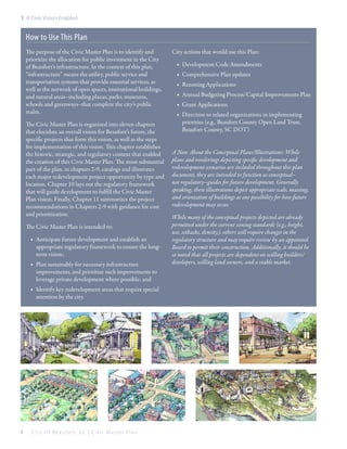
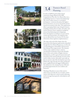
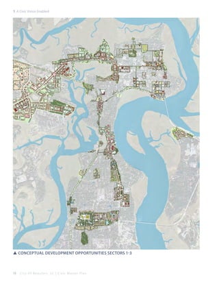
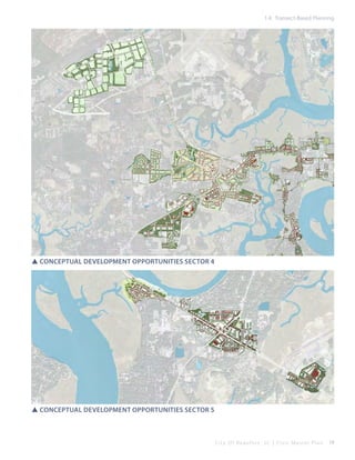
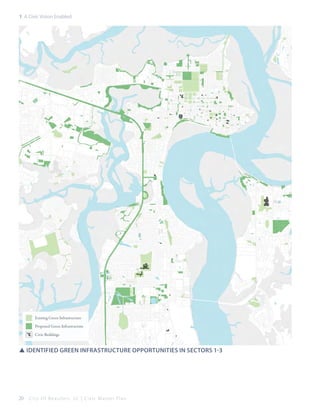
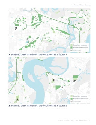
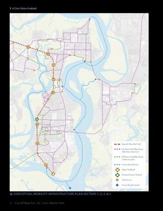
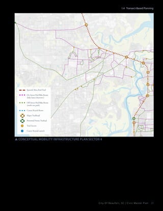
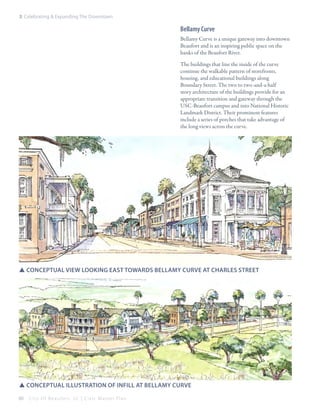
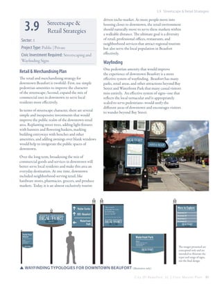
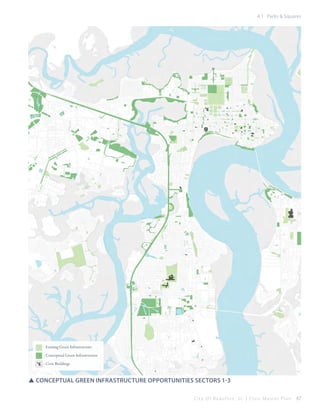
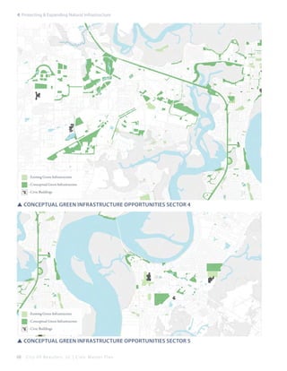
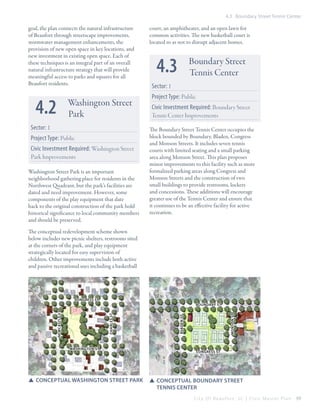
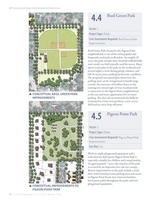
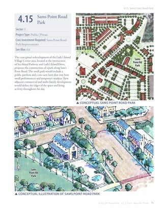
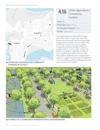
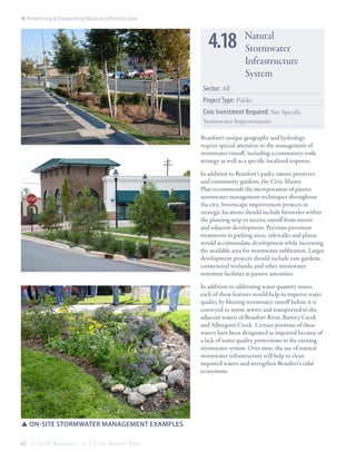
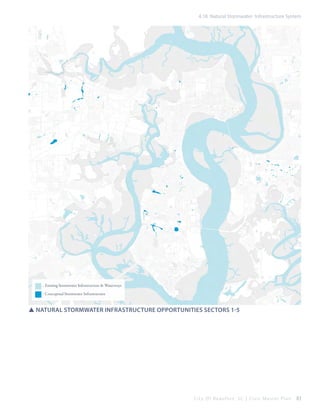
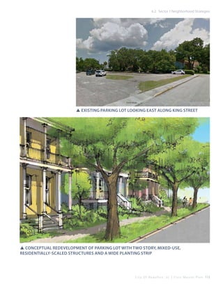
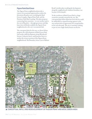
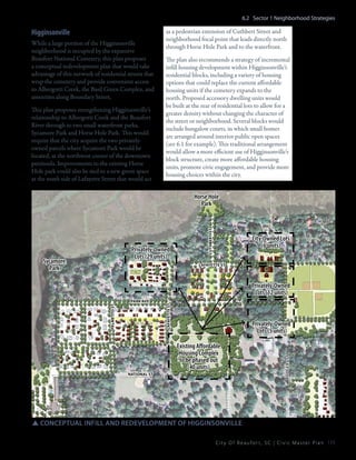
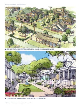
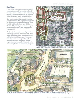
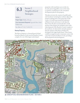
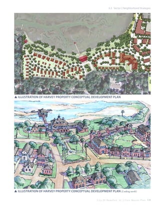
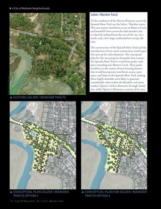
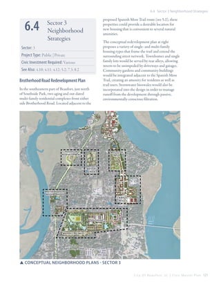
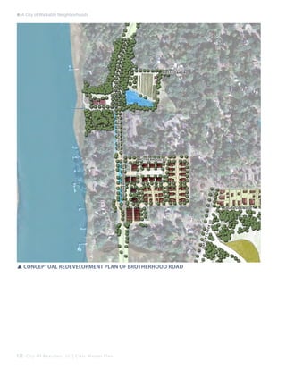
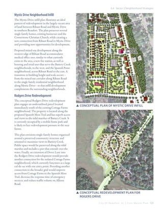
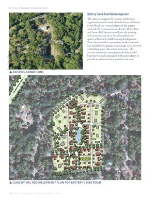
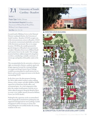
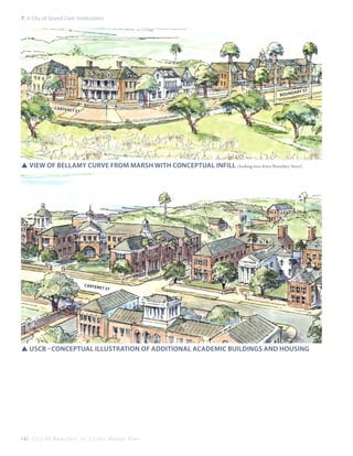
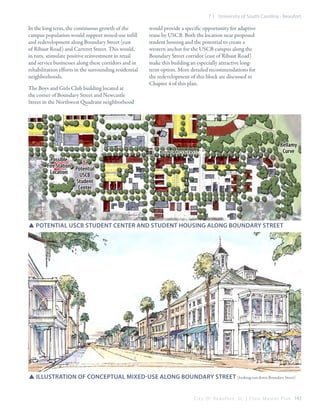
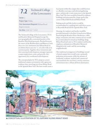
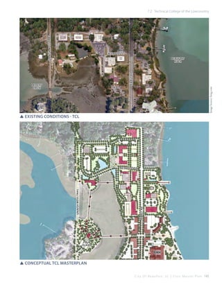
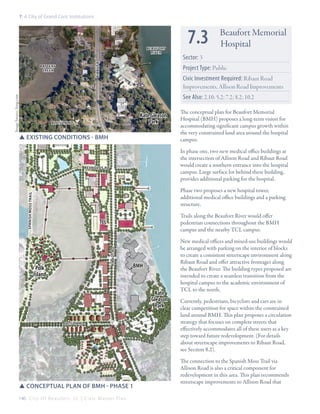
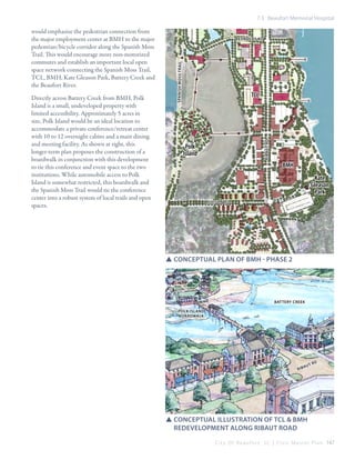
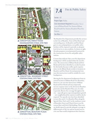
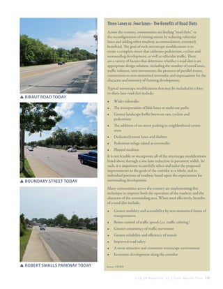
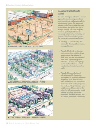
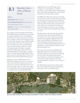
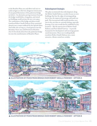
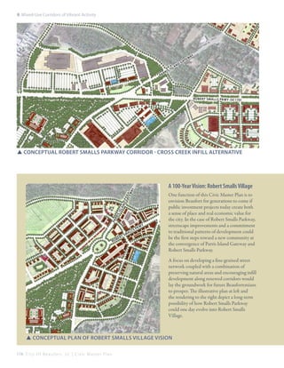
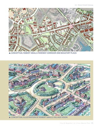
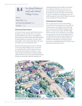
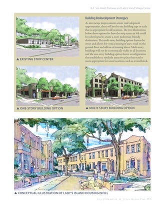
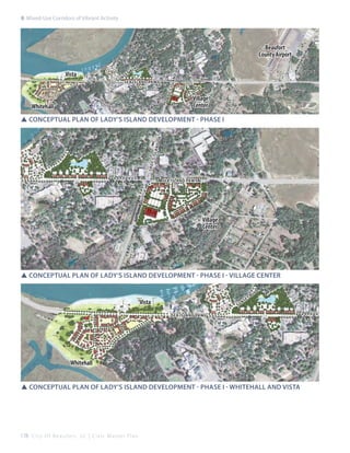
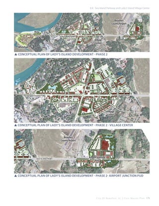
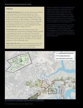
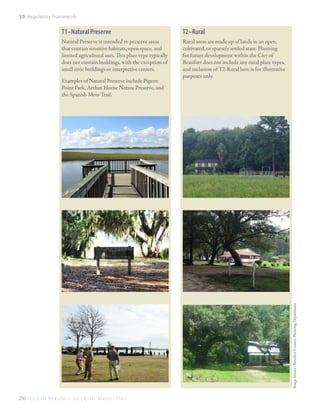
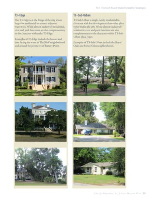
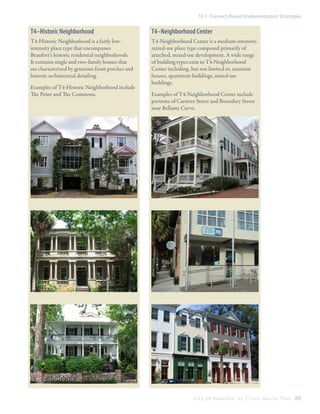
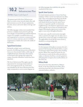
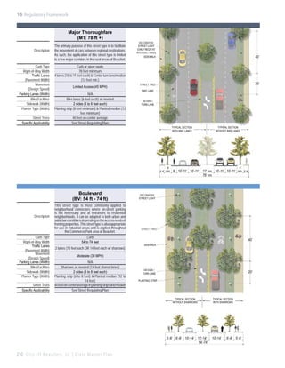
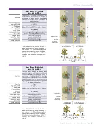
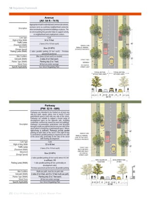
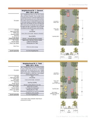
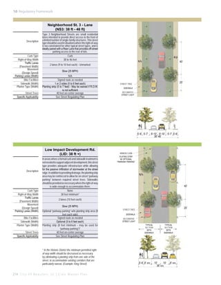
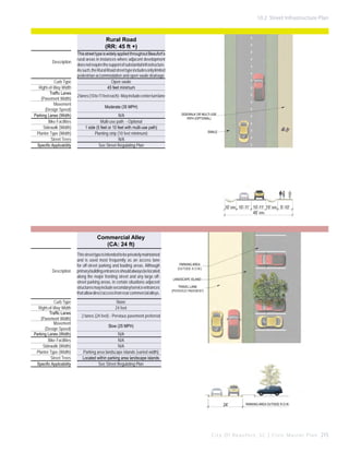
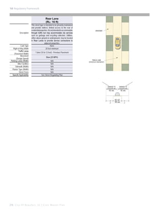
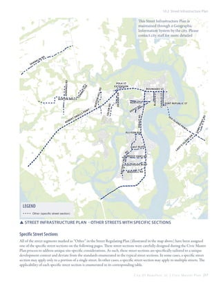
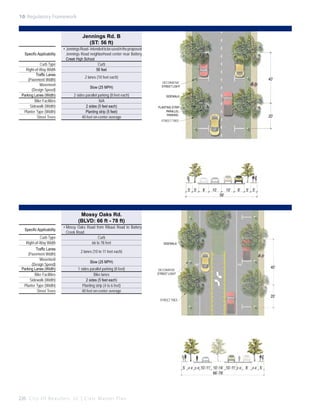
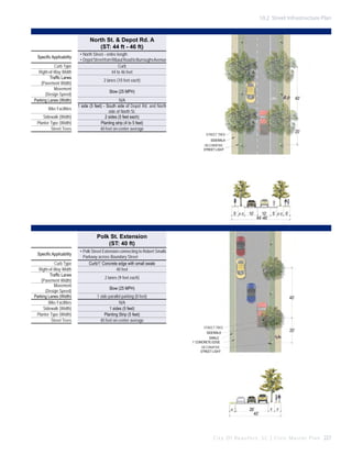
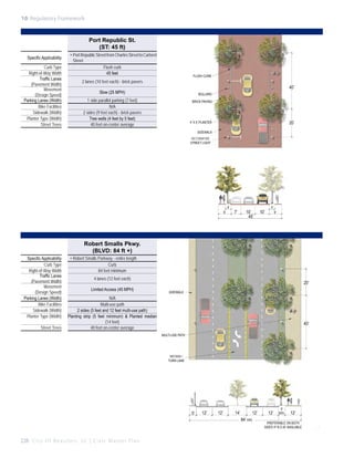
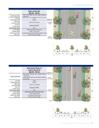
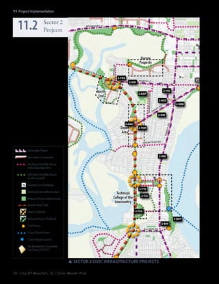
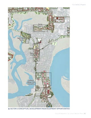
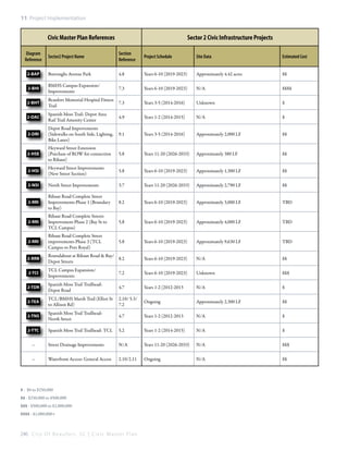
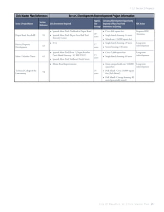
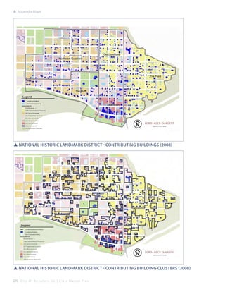
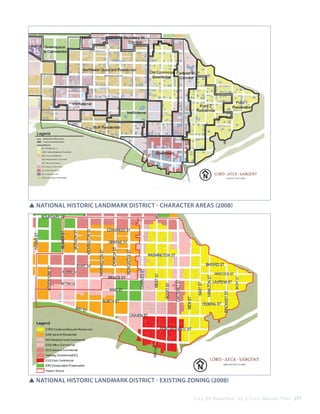
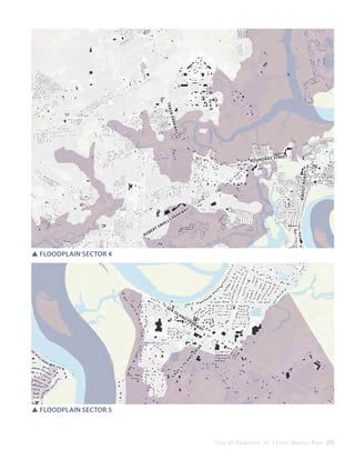
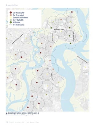
C ivic master plan
CITY of BEAUFORT, south carolina
Draft 10/18/2013
©2013 by Lawrence Group and the City of Beaufort. All Photos and Images by Lawrence Group and their
sub consultants unless otherwise noted. Reproduction Permitted with Credit in Print.
DRAFT - 10.18.2013
ii

City Of Beaufor t, SC | Civic Master Plan


This Civic Master Plan was prepared for
The City of Beaufort, south Carolina
Beaufort Redevelopment Commission
Jon Verity, Chair
Michael McNally, Vice-Chair
Pat Case (2010-2012)
Alan Dechovitz
Henrietta Goode
Martin Goodman
Michael McFee
Stephen Murray
Keith Waldrop
Wendy Zara

Beaufort City Council
Billy Keyserling, Mayor
Donnie Beer
Michael McFee
George O’Kelley
Michael Sutton

city staff
Scott Dadson, City Manager
Kathy Todd, Chief Financial Officer
Libby Anderson, Planning Director
Lauren Kelly, Planner
Liza Hill, Planner
Craig Lewis, Office of Civic Investment Program Manager
Julie Franklin, Office of Civic Investment
Josh Martin, Office of Civic Investment

Project team
Lawrence Group | Craig Lewis, Project Manager; Aleksandra Borisenko, Scott Curry, Julie Franklin, Monica Carney Holmes,
Amanda Huggins, David Malushizky, Josh Martin, Keihly Moore, Jeff Ream, Carolyn Reid, David Walters
Metrocology | Demetri Baches, Mallory Baches
Seth Harry & Associates | Seth Harry, Patrick Zimmerman
The Purple Shamrock | Lauren Kelly
The Leeman Group | Naomi Leeman
Fuss and O’Neill | Wade Walker, Jennifer Nelson
Rock Maple Studio | James Wassell
Allison Ramsey Architects | Cooter Ramsey
Brown Design Studio | Eric Brown
Seahaven Consulting | Leslie Pickel
Project Interns | Aaron Aeschliman, Oscar Carlsan, Seth Crawford, Allen Davis, Nicole Goss, Antonio Kaparis, Kameron
King, Adam Martin, Andrew McIntyre, Peter Miller, Matt Morris, Adam Pinter, Carol Santana, Lindsay Shelton, Will Sendor,
Rachel Wheeler, Nick Wilder
City Of Beaufor t, SC | Civic Master Plan

i
1

A Civic Vision Enabled	

1

1.1 The Planning Context: Past, Present and Future
. . . . . . . . . . . . . . . . . . . . . . . . . . . . . . . . . . . . . . . 5

4

Protecting & Expanding
Natural Infrastructure	 65
4.1 Parks & Squares. . . . . . . . . . . . . . . . . . . . . . . . . . 68

1.2 Plan Origins. . . . . . . . . . . . . . . . . . . . . . . . . . . . . . 7
1.3 The Sector Plans, Process and Content. . . . . . . 12

4.3 Boundary Street Tennis Center . . . . . . . . . . . . . 71

1.4 Transect-Based Planning. . . . . . . . . . . . . . . . . . 16

2

4.2 Washington Street Park. . . . . . . . . . . . . . . . . . . 71

4.4 Basil Green Park . . . . . . . . . . . . . . . . . . . . . . . . . 72

The Public Waterfront	

4.5 Pigeon Point Park. . . . . . . . . . . . . . . . . . . . . . . . 72

25

4.6 Horse Trough Park. . . . . . . . . . . . . . . . . . . . . . . . 73

2.1 Regional Waterfront Connectivity Plan. . . . . . 29

4.7 Bay Street/Ribaut Road Intersection Park. . . . 74

2.2 Marina Parking Lot Redevelopment. . . . . . . . . 30

4.8 Burroughs Avenue Park /School. . . . . . . . . . . . 74

2.3 Marina Improvements. . . . . . . . . . . . . . . . . . . . 32

4.9 Depot Plaza. . . . . . . . . . . . . . . . . . . . . . . . . . . . . 75

2.4 Henry C. Chambers Waterfront Park Gateway
Improvements. . . . . . . . . . . . . . . . . . . . . . . . . . 33

4.10 Southside Park. . . . . . . . . . . . . . . . . . . . . . . . . . 77

2.5 Bay Street Boardwalk. . . . . . . . . . . . . . . . . . . . . 34
2.6 Bellamy Curve. . . . . . . . . . . . . . . . . . . . . . . . . . . 36

4.12 Waddell Gardens Nature Preserve. . . . . . . . . . 78

2.7 Lady’s Island Waterfront Access. . . . . . . . . . . . .37

4.13 Burton Wells Park . . . . . . . . . . . . . . . . . . . . . . . 79

2.8 Mossy Oaks Waterfront Access . . . . . . . . . . . . . 38

4.14 Beaufort Plaza Parks. . . . . . . . . . . . . . . . . . . . . 80

2.9 Boundary Street Waterfront Access . . . . . . . . . 38

4.15 Sams Point Road Park. . . . . . . . . . . . . . . . . . . . 81

2.10 TCL/BMH Waterfront Access. . . . . . . . . . . . . . . 40

4.16 Urban Agriculture/Community Gardens . . . . . 82

2.11 Battery Creek Marshfront Park. . . . . . . . . . . . . 41

4.17 Urban Tree Canopy . . . . . . . . . . . . . . . . . . . . . . . 83

2.12 Preserved Waterfront Views. . . . . . . . . . . . . . . 43

3

4.11 Arthur Horne Nature Park. . . . . . . . . . . . . . . . . 78

4.18 Natural Stormwater Infrastructure System. . . 84

Celebrating & Expanding
The Downtown 	
47

Community Mobility
at Our Speed 	

5

3.1 National Landmark Historic District. . . . . . . . . 50

5.1 Streets & Public Spaces . . . . . . . . . . . . . . . . . . . 90

3.2 Redefining & Expanding “Downtown”. . . . . . . 52

5.2 Spanish Moss Trail. . . . . . . . . . . . . . . . . . . . . . . . 91

3.3 Port Republic Street. . . . . . . . . . . . . . . . . . . . . . 53

5.3 Pedestrian & Bicycle Infrastructure . . . . . . . . . 93

3.4 Parking Structure . . . . . . . . . . . . . . . . . . . . . . . . 54

5.4 Boat Access/Water Taxi. . . . . . . . . . . . . . . . . . . . 96

3.5 Carteret Street. . . . . . . . . . . . . . . . . . . . . . . . . . . 55

5.5 Connectivity. . . . . . . . . . . . . . . . . . . . . . . . . . . . . 97

3.6 Charles Street . . . . . . . . . . . . . . . . . . . . . . . . . . . 57

5.6 Streetscape Improvements. . . . . . . . . . . . . . . . 97

3.7 Bladen Street. . . . . . . . . . . . . . . . . . . . . . . . . . . . 58
3.8 Boundary Street (East of Ribaut Road) & Bellamy
Curve . . . . . . . . . . . . . . . . . . . . . . . . . . . . . . . . . 60
3.9 Streetscape & Retail Strategies. . . . . . . . . . . . . 63
ii

City Of Beaufor t, SC | Civic Master Plan

87


6

A City of Walkable
Neighborhoods 	

103

9

Districts for Economic
Development Activity	

6.1 Building Typologies. . . . . . . . . . . . . . . . . . . . . .106

9.1 Depot Road Area. . . . . . . . . . . . . . . . . . . . . . . . 187

6.2 Sector 1 Neighborhood Strategies. . . . . . . . . 110

9.2 Commerce Park. . . . . . . . . . . . . . . . . . . . . . . . . 189

6.3 Sector 2 Neighborhood Strategies. . . . . . . . . 120

9.3 Burton Industrial Area. . . . . . . . . . . . . . . . . . . 191

6.4 Sector 3 Neighborhood Strategies. . . . . . . . . 123

183

9.4 Strategic Opportunity Sites. . . . . . . . . . . . . . . 193

6.5 Sector 4 Neighborhood Strategies. . . . . . . . . 129

10 Regulatory framework	

6.6 Sector 5 Neighborhood Strategies. . . . . . . . . 133

195

10.1 Transect-Basedc Implementation
Strategies. . . . . . . . . . . . . . . . . . . . . . . . . . . . . 198

10.2 Street Infrastructure Plan . . . . . . . . . . . . . . . 207

7.1 University of South Carolina - Beaufort. . . . . 143

7

A City of Grand Civic
Institutions	139

10.3 Proposed Zoning Changes for the National Landmark Historic
District . . . . . . . . . . . . . . . . . . . . . . . . . . . . . . . 234

11

7.2 Technical College of the Lowcountry . . . . . . . 146
7.3 Beaufort Memorial Hospital . . . . . . . . . . . . . . 148

Project Implementation	 235

7.4 Fire & Public Safety. . . . . . . . . . . . . . . . . . . . . . 150
7.5 Elementary/Secondary Schools . . . . . . . . . . . 152

11.2 Sector 2 Projects . . . . . . . . . . . . . . . . . . . . . . . 244

7.6 Churches & Other Religious Buildings . . . . . . 154

11.3 Sector 3 Projects . . . . . . . . . . . . . . . . . . . . . . . 248

7.7 Marine Corps Air Station-Beaufort. . . . . . . . . 155

8

11.1 Sector 1 Projects . . . . . . . . . . . . . . . . . . . . . . . 240

11.4 Sector 4 Projects . . . . . . . . . . . . . . . . . . . . . . . 252

Mixed-Use Corridors of
Vibrant Activity	

11.5 Sector 5 Projects . . . . . . . . . . . . . . . . . . . . . . . 256

157

Appendix : Maps	

261

8.1 Boundary Street (West of Ribaut Road) . . . . 163
8.2 Ribaut Road. . . . . . . . . . . . . . . . . . . . . . . . . . . . 169

Index	285

8.3 Robert Smalls Parkway . . . . . . . . . . . . . . . . . . 174
8.4 Sea Island Parkway and Lady’s Island Village
Center. . . . . . . . . . . . . . . . . . . . . . . . . . . . . . . . 178

City Of Beaufor t, SC | Civic Master Plan

iii
1

A Civic Vision Enabled
Key Strategies
A tangible sense of history is central to Beaufort’s
identity. The way the city is laid out, the manner in
which it has been built, rebuilt and extended over three
hundred years, and its fundamental relationship to
its natural environment of sea, marsh and farmland,
underpins its citizens’ sense of identity and place in a
fast-changing, globalizing world.

In this chapter

1.1 The Planning Context: Past, Present and Future.  	
. . . . . . . . . . . . . . . . . . . . . . . . . . . . . . . . . . . . . . . 5
1.2 Plan Origins. . . . . . . . . . . . . . . . . . . . . . . . . . . . . . 7
1.3 The Sector Plans, Process and Content. . . . . . . 12
1.4 Transect-Based Planning. . . . . . . . . . . . . . . . . . 16
1: A Civic Vision Enabled

How to Use This Plan
The purpose of the Civic Master Plan is to identify and
prioritize the allocation for public investment in the City
of Beaufort’s infrastructure. In the context of this plan,
“infrastructure” means the utility, public service and
transportation systems that provide essential services, as
well as the network of open spaces, institutional buildings,
and natural areas–including plazas, parks, museums,
schools and greenways–that complete the city’s public
realm.
The Civic Master Plan is organized into eleven chapters
that elucidate an overall vision for Beaufort’s future, the
specific projects that form this vision, as well as the steps
for implementation of this vision. This chapter establishes
the historic, strategic, and regulatory context that enabled
the creation of this Civic Master Plan. The most substantial
part of the plan, in chapters 2-9, catalogs and illustrates
each major redevelopment project opportunity by type and
location. Chapter 10 lays out the regulatory framework
that will guide development to fulfill the Civic Master
Plan vision. Finally, Chapter 11 summarizes the project
recommendations in Chapters 2-9 with guidance for cost
and prioritization.
The Civic Master Plan is intended to:
■■ Anticipate future development and establish an
appropriate regulatory framework to ensure the longterm vision;
■■ Plan sustainably for necessary infrastructure
improvements, and prioritize such improvements to
leverage private development where possible; and
■■ Identify key redevelopment areas that require special
attention by the city.

4

City Of Beaufor t, SC | Civic Master Plan

City actions that would use this Plan:
■■ Development Code Amendments
■■ Comprehensive Plan updates
■■ Rezoning Applications
■■ Annual Budgeting Process/Capital Improvements Plan
■■ Grant Applications
■■ Direction to related organizations in implementing
priorities (e.g., Beaufort County Open Land Trust,
Beaufort County, SC DOT)
A Note About the Conceptual Plans/Illustrations: While
plans and renderings depicting specific development and
redevelopment scenarios are included throughout this plan
document, they are intended to function as conceptual–
not regulatory–guides for future development. Generally
speaking, these illustrations depict appropriate scale, massing,
and orientation of buildings as one possibility for how future
redevelopment may occur.
While many of the conceptual projects depicted are already
permitted under the current zoning standards (e.g., height,
use, setbacks, density), others will require changes in the
regulatory structure and may require review by an appointed
Board to permit their construction. Additionally, it should be
so noted that all projects are dependent on willing builders/
developers, willing land owners, and a viable market.
1.1 The Planning Context: Past, Present and Future

1.1

The Planning
Context: Past,
Present and Future

A tangible sense of history is central to Beaufort’s
identity. The street grid established in the 18th
century and extended over three hundred years,
and its fundamental relationship to its natural
environment of sea, marsh and farmland underpins
its citizens’ sense of identity and place in a fastchanging, globalizing world.
This sense of history and place is critical to
Beaufort’s role as a distinct and significant player
in the economy and identity of the Lowcountry.
With well-established institutions and businesses,
the city serves as an important secondary urban
center and tourist destination to the larger markets
in Charleston, South Carolina and Savannah,
Georgia.
As in many American cities, a progressive
detachment from history and sense of place can
be seen in the changing townscape of Beaufort.
The developments built in the last fifty years are
scaled to the automobile, not the person, and
were often designed with generic buildings and
landscapes that create a built environment virtually
indistinguishable from hundreds of other places
across the country. Within this new complex
urban form, of both the very best of walkable
urbanism and some of the most auto-oriented
suburban sprawl, Beaufort struggles to define itself
economically in today’s challenging and dynamic
marketplace, and could – without a cohesive plan
for the future – become no more than a stopover
for the region in the future.
While a modern Beaufort must be more than
simply an extension of its historic framework,
there is an opportunity to reintegrate lessons
from historical patterns of growth into new
developments, and into the redevelopment of areas
submerged in the placeless patterns of the late 20th
century. A living sense of history does not try to
turn back the clock and reenact the past; instead
it seeks out principles and precedents which are
as relevant today as they were one hundred, or
even three hundred, years ago. These principles
may involve the siting and orientation of buildings
to minimize the use of expensive energy, or the
City Of Beaufor t, SC | Civic Master Plan

5
1: A Civic Vision Enabled

design of public space that is scaled for people and
where cars can gain convenient access without
dominating. This approach looks to create new
developments that carefully honor and respect
history while allowing for legitimate expressions of
modern culture.

Image Source: Historic Beaufort Foundation

While very specific to Beaufort’s past, present
and future, the recommendations of this Civic
Master Plan are based on a series of planning
and design principles most easily identified as
“traditional urbanism”: a time-tested arrangement
of public spaces, buildings, and corridors that
allows residents to walk to meet their daily needs.
These different types of public space, including
residential streets, boulevards, squares, plazas,
parks, playgrounds and other natural landscape
areas, all demonstrate a common respect for
human scale. While accommodating the car, and
incorporating today’s large commercial structures
in locations where appropriate, this method of
urban design always emphasizes the pedestrianfriendly environment.

6

City Of Beaufor t, SC | Civic Master Plan

This human-scale development is essential in
reconnecting Beaufort and its citizens to their
Lowcountry prominence and the community’s
historic precedent. It also sets the foundation
for increased future prosperity, with growth
encouraged first in areas already developed with
existing infrastructure, and development in new
areas managed in ways that protect the city’s
precious historic and natural landscapes.
1.2 Plan Origins

•	

First, it eliminated the annexation of lowdensity and land-consuming development
as the primary means for city growth, and
replaced these outdated ideas with a vision
of growth and resiliency through infill and
redevelopment.

•	

Second, it prioritized, edited and consolidated
several years’ worth of unfulfilled planning
efforts with contradictory and outdated
concepts, and created a single, coherent set of
policy guidelines.

Upon adoption of the Comprehensive
Plan, Beaufort’s City Council gave the city’s
Redevelopment Commission the following
tasks: 1) conduct an audit of existing policies and
conditions; 2) translate the Comprehensive Plan
vision into specific parcel-level plans for public
and private investment; and 3) implement a new
form-based regulatory framework for development.
The City Council also created the Office of Civic
Investment to provide professional support to the
Redevelopment Commission in completing these
tasks, and to manage cross-department and crossagency redevelopment projects.

Image Source: www.polawanaisland.com

The 2009 “Vision Beaufort” Comprehensive Plan
included a wealth of information about targeting
public investment, establishing community design
objectives, pursuing potential catalyst projects, and
most importantly, implementing the vision that will
guide Beaufort into the next decade of growth and
development. Additionally, the Comprehensive
Plan accomplished two important shifts in policy:

Image Source: www.polawanaisland.com

1.2

Plan Origins

Under the direction of the Redevelopment
Commission, the Office of Civic Investment
coordinated the Civic Master Plan process to
develop a detailed plan for public investment based
on the framework adopted in the Comprehensive
Plan. The intention was to avoid generic “place-less”
development in favor of sustainable development
that is unique to Beaufort. This initiative
recognized that each of the city’s neighborhoods
contains its own unique history, character, and
physical attributes which should be respected and
emphasized in future development

City Of Beaufor t, SC | Civic Master Plan

7
1: A Civic Vision Enabled

This Civic Master Plan is the result of extensive
collaborative efforts, including an intensive public
input process. It establishes general principles and
standards for all public and private development,
and provides a guide for identifying and promoting
investment within the city.
The plan presents proposals graphically to provide
residents and businesses with a conceptual vision
of development options, and to serve as a tool
to stimulate a range of development and/or
redevelopment opportunities throughout Beaufort.
Additionally, the plan illustrates proposals that
seek good financial returns for property owners
in contemporary market conditions, while
establishing design standards and qualities that are
compatible with those found in the older, historic
parts of the community. In this way, a distinct
regional image and character can be (re)established
over time, in a way that sets Beaufort apart from
other communities, and attracts residents and
businesses seeking a distinctive place to live and
work.
The plan is a compilation of long-term visions
and short- to medium-term tools and strategies,
all coherently presented within one document.
Like many community plans, this plan is expected
to generate discussion points, establish budget
priorities, and create implementation objectives
for the city over the next generation. In fact, the
comprehensive nature of this effort, along with
the timing of its occurrence at Beaufort’s 300year anniversary, marks a milestone for the city.
The Civic Master Plan lays the groundwork for a
prosperous and resilient Beaufort for another 300
years to come.

8

City Of Beaufor t, SC | Civic Master Plan
1.2 Plan Origins

Vision Beaufort: 2009 Comprehensive Plan
In 2009, the City of Beaufort adopted “Vision Beaufort,” a
comprehensive plan that articulated a vision for the growth and
development of the city. In completing the plan, a broadly inclusive
public participation process was used to ensure that the vision
established in the plan was shared by a wide variety of Beaufort
citizens, and truly reflective of the aspirations of the general public,
elected officials, city staff, the development and business community.

In the Comprehensive Plan, the City of Beaufort and its citizens
envisioned a city with:
■■ Beautiful, stable neighborhoods;
■■ A common community vision;
■■ A sustainable economic base;
■■ Transportation options and convenient access to services and
destinations;
■■ Attractive and vital community gateways and corridors;

V I SION
BE AUF ORT

2009 Comprehensive Plan
Adopted by City Council
12.08.2009

■■ Natural resources that balance protection with public access and
enjoyment;
■■ A balance between preservation and sensitive infill and
redevelopment of our historic core;
■■ A predictable development process for citizens and developers
alike; and

five: a framework for growth

■■ A welcoming atmosphere to all people.

To help achieve this vision, the plan committed to building upon and
protecting Beaufort’s assets and strengths of:
■■ Natural beauty and open spaces;
■■ Unique community design and historic atmosphere;
■■ Access to local goods, services, and cultural amenities;
■■ Military presence, hospital, and higher education institutions; and
■■ Community interaction and small community feel.

ComPlete framework iNCorPoratiNg tHe
eNtire urBaN growtH BouNdary

vision Beaufort | 2020 Comprehensive plan

56

SS2009 comprehensive plan

City Of Beaufor t, SC | Civic Master Plan

9
1: A Civic Vision Enabled

1
2

3

10

	 Sustainability
	 The activities of the City of Beaufort
will consider the balance of social,
environmental, and economic
sustainability principles for both the
community and the private property
owner with all of our decisions.


We are committed to the implementation
of the Northern Beaufort County Regional
Plan as a guideline for our regional
decisions and future urban form and we
will continue to engage and coordinate in
regional planning activities. Our planning
will extend to the established urban
growth boundary and will tie together
all areas of the community in a cohesive
manner.

Growth


We must encourage growth within our
urban service area by primarily focusing
on the regeneration of our current
assets through infill and redevelopment.
Development in our urban growth
boundary shall be sensitively focused on
a conservation ethic with a compact and
efficient built form that could be serviced
with municipal services in the future.


Economic Development


A strong, vibrant, and healthy economy
will be achieved through a successful
economic development program in
order to ensure the long term success and
viability of the City of Beaufort. We must
support the continuation and expansion of
our primary economic engines - tourism,
the military, healthcare,and education while also seeking to expand opportunities
for the arts and the recruitment of
creative/knowledge-based industries.


Access and Mobility


Our citizens and visitors need a
transportation system that integrates
regional solutions with a fine-grained local
network of choices that accommodate the
automobile, pedestrians, bicyclists, and
water-based travel.

Regionalism


4


Natural Infrastructure


We must protect our environmental
resources as fundamental to the natural
ecosystem and our quality of life. We will
utilize innovative and context-sensitive
solutions to conserve and protect our
natural resources including our salt
marshes, marsh islands, coastal waters,
and marine resources; trees, forests,
and wildlife habitats; and open space
preservation.

5

City Of Beaufor t, SC | Civic Master Plan

6
1.2 Plan Origins

7


Urban Form


The city will maintain its distinct
urban form by encouraging growth and
development using the model of walkable,
urban, mixed-use neighborhoods
established by the historic core of the city.

8


Neighborhoods


We believe that all our neighborhoods,
including the downtown, must be vibrant
and diverse and thus require consistent
and continual public and private attention,
maintenance and re-investment. Our
neighborhoods should be reinforced in all
planning and infrastructure projects.

9


Parks & Public Open Spaces


The city will permanently preserve
and expand a community-wide parks,
recreation and open space network
that serves the entire city from the
neighborhood playground to the regional
reserve.

13 Climate Change
	

	We must participate in solutions that
reduce or avoid potential impacts to our
regional and global climate and in turn we
must adapt to those conditions which are
likely to be inevitable, most specifically sea
level rise.

14 Resource Efficiency
	

	 We will manage our consumption of
renewable and non-renewable resources
including energy and water and will
continue to reduce our total waste
stream. In addition we will be supportive
of community activities that promote
resource efficiency and the production of
alternative energy and innovative water use
and protection practices.

15

	 Fiscal Sustainability
	 The city, as a provider of urban services,
must focus on long-term solvency with
each incremental decision. Capital
investments should leverage future
benefits and must consider the impact
on long term operational costs prior to
their implementation. Perhaps most
importantly, we will constantly seek
efficient and innovative ways in which to
deliver services and maintain our assets.

10 Historic and Cultural Resources
	

	 Beaufort is a living, dynamic community
and must balance the protection of its
abundant natural, cultural, institutional
and historic resources with managed
growth that adds to the community’s
character for future generations without
degrading those resources which we value.

11 Social Diversity
	

We will maintain and celebrate the
integrated ethnic and socioeconomic
diversity of the community. To this
end, we are committed to the provision
of affordable and workforce housing
throughout the city.

12 Hazard Mitigation
	

	As a coastal community, we will feel the
direct impacts of tropical storm activity
and flooding. We must be prudent in our
preparation for these expected hazards and
mitigate against the loss of property to the
greatest extent practical.

16 Adequacy of Infrastructure and
Facilities


The contiguous extension of our corporate
boundaries will be considered to the extent
that the provision of city services can be
economically and efficiently provided and
will be subject to the adequate availability
and timely construction of community
infrastructure and public facilities.

17 Planning & Implementation
	

	 We will continue our history of
thoughtful, detailed planning and will
include practical implementing elements
to leverage our ideas with actions. Success
is bred not from what we say but what we
accomplish.

City Of Beaufor t, SC | Civic Master Plan

11
1: A Civic Vision Enabled

1.3

The Sector Plans,
Process and
Content

The first steps of the Civic Master Plan process
involved collecting information through meetings
with individuals, groups, and organizations, gaining
data through on-the-ground, parcel-level surveys,
and reviewing previously completed plans, reports,
and studies.
Then, for planning purposes, the city was divided
into five manageable sectors:
Sector 1 	 The Historic District and Environs:
The Point, Downtown, The Bluff, The
Northwest Quadrant, Pigeon Point,
Higginsonville
Sector 2 	 The Northern Portion of the Lower
Peninsula: Salzer/Marsher Farm, Depot,
Hundred Pines, the Technical College of
the Lowcountry (TCL) campus and the
Hospital district
Sector 3 	 The Southern Portion of the Lower
Peninsula: Cottage Farm, Jericho
Woods, Spanish Point, Royal Oaks and
Mossy Oaks

within the community, so that citizens could
participate in conversations with the designers,
planners and traffic specialists, monitor and check
on progress, and comment on the proposals as they
evolved.
Each Sector Plan includes the following elements:
•	

A synoptic survey of each lot in Sector 1-3
documenting lot size, lot coverage, building
conditions, setbacks, building height, public
frontage/streetscape, and private frontage.

•	

Physical development/redevelopment plans to
the parcel level with conceptual development
alternatives that demonstrate the preferred
lot arrangements, building typologies and
frontages;

•	

Physical infrastructure plans illustrating
preferred street sections for all streets and
required improvements;

•	

Natural systems plans illustrating preferred
stormwater management techniques, open
space protection/preservation, water access,
watercourse buffers, and other natural areas;

•	

Civic infrastructure plans identifying
opportunities to improve, expand, and/or
inject new community facilities/amenities;

Sector 4 	 Areas within the city limits west of
Ribaut Road and Battery Creek Road:
western portions of Boundary Street, the
Burton area, the Robert Smalls Parkway,
Parris Island Gateway corridors, the
Salem Farms area, and the Marine Corps
Air Station
Sector 5 	 Lady’s Island and Whitehall.
The Sector Plans were developed through extensive
public participation from key stakeholders, elected
officials and the general public. The five geographic
areas were grouped together into a sequence of
three major public processes: Sector 1; Sectors 2
and 3 combined; and Sectors 4 and 5 combined.
Each public process utilized a series of public
preparatory meetings to discuss issues and establish
key facts and information, followed by a week-long
charrette, or detailed public design workshop. Each
of the three charrettes were held in public venues

SSexample of synoptic survey
12

City Of Beaufor t, SC | Civic Master Plan
1.3 The Sector Plans, Process and Content

Sector 1
Sector 2
Sector 3
Sector 4
Sector 5

The Beaufort Sector Map A Sector is a planning area of the City of Beaufort. Sector boundaries were
determined based on neighborhood locations, types of development, and natural features. The Office of Civic Investment
devised the sector boundaries for the purpose of study over two years. Sector 1 encompassed the Downtown Beaufort
Peninsula. Sector 2 and 3 included the Beaufort neck and Southern Peninsula. The final sectors, Sector 4 and 5, include
the future growth periphery area for the City of Beaufort.

City Of Beaufor t, SC | Civic Master Plan

13
1: A Civic Vision Enabled

•	

Civic investment strategies identifying
capital and operating needs for the sector and
prioritizing improvements and investments;

•	

Calibration of transect-based districts to the
parcel-level; and

•	

Extensive illustrations providing a visual palette
from which to market various development/
redevelopment opportunities at the parcel
level.

The planning of Sector 1 was predicated by the
need to redefine the perception of the commercial
area of downtown Beaufort beyond the few blocks
along Bay and Port Republic Streets, a very narrow
and constrained area that offers few opportunities
for phyiscal expansion. The Civic Master Plan
process therefore introduced an expanded view of
the downtown commercial area extending along
Boundary Street, Bladen Street, Carteret, and
Charles Streets. Expanding the idea of “downtown,”
eliminated previous pressures to force every
Beaufort destination into a few blocks. These use
of these corridors are organizing elements gives rise
to greater organization amongst the surrounding
neighborhood blocks and provides pathways and

14

City Of Beaufor t, SC | Civic Master Plan

destinations for residents to enjoy and be served by
beyond the two blocks of Bay Street.
Sectors 2 and 3 were combined into one study area
for the purpose of analysis. Sector 2 was defined
as all the neighborhoods east of Battery Creek, up
to and including the campuses of the Technical
College of the Lowcountry and Beaufort Memorial
Hospital. Sector 3 incorporated the neighborhoods
south of the two campuses as far as the municipal
boundary with the Town of Port Royal. Sectors
2 and 3 combined represent a peninsula with the
main corridors of Ribaut Road and the Spanish
Moss Trail. These two campuses, centrally located
between the two residential sectors, represented
the highest employment concentration in the
City of Beaufort. Just as the Civic Master Plan
“reconsidered” what constituted downtown, so too
did it “reconsider” what it means to live and work
on a peninsula. The Plan’s focus aimed at providing
amenity and connection to the greater community
and natural environment by creating stronger access
to the waterfront through parks and retained views.
Sector 4 extended along Boundary Street from City
Hall past Highway 170 to Burton, and southwest
1.3 The Sector Plans, Process and Content

along Highway 170. It included all municipal
land on the west side of Battery Creek, mostly
suburban and servicing the largest portion of the
community’s general shopping needs.
Sector 5 covered the area of the city that extends
onto Lady’s Island to its east, with Sea Island
Parkway and Highway 802 serving a series of
business and planned developments on marsh
islands and providing access to Sectors 1 and 3
via major bridges. Sector 5 is largely a suburban
environment and the location of a significant
portion of the community’s higher-end shopping.
And finally, once a full draft of the Plan was
prepared, the Redevelopment Commission held
an additional series of public workshops both for
public sectors and the overall community to gather
further public input. In total, the city conducted
more than a hundred public evaluation forums
over the past 2½ years in the form of week-long
charrettes (3), open public workshops (17),
neighborhood walking tours, numerous small
group and individual discussions.

City Of Beaufor t, SC | Civic Master Plan

15
1: A Civic Vision Enabled

1.4

Transect-Based
Planning

In order to fulfill the goals of place-based
community design adopted in the 2009
Comprehensive Plan, the Civic Master Plan uses a
methodology known as “transect-based planning.”
The rural-to-urban transect is a conceptual
development continuum that places the highestdensity downtown core at one end and the pristine
natural environment at the other. This organization
allows a grouping of place types along the transect,
including variations that are urban, sub-urban, and
rural in character. From a regulatory standpoint,
transect-based planning means designating
future development according to an area’s current
context and characteristics, not simply by what
uses are allowed there (see Section 10.1 for more
information about regulatory implementation.)
The maps at the end of this chapter show the
framework of development opportunities identified
through the Civic Master Plan process, as well as the
corresponding green and mobility infrastructures
that underpin those opportunities. The elements
of these maps combine to form a cohesive,
citywide plan for Beaufort’s future that identifies
future centers and corridors of higher-intensity
development, as well as spaces for preservation and
restoration of the natural landscape. In terms of the
rural-to-urban transect, these place types make up
the two extreme ends of the development spectrum.
Within this range, this plan also maps existing and
future neighborhoods and suggests infill projects
that will preserve the existing character while also
providing opportunities for new residents and
businesses.
Thinking of Beaufort in terms of the rural-tourban transect provides the city, its leaders, and its
citizens with improved, context-sensitive planning
tools to manage future growth, redevelopment and
investment.

16

City Of Beaufor t, SC | Civic Master Plan
1.4 Transect-Based Planning

The Civic Master Plan vision:
Celebrates the waterfront and the city’s natural environment
Imagines mixed-use and walkable neighborhoods connected by greenways and urban corridors
Enables residents to live locally with the option of walking or biking to meet their daily needs
Positions the community for an era beyond our current pattern of dependence on cars
Establishes a green infrastructure of parks and greenways on a local and regional scale
Envisions regional connections to strengthen Beaufort’s economy and cultural institutions
Engages a wide variety of people and lifestyles across a broad socio-economic spectrum
Preserves Beaufort’s historical and architectural legacy without compromising opportunities for new development

City Of Beaufor t, SC | Civic Master Plan

17
1: A Civic Vision Enabled

SSConceptual development opportunities sectors 1-3

18

City Of Beaufor t, SC | Civic Master Plan
1.4 Transect-Based Planning

SSConceptual development opportunities sector 4

SSConceptual development opportunities sector 5

City Of Beaufor t, SC | Civic Master Plan

19
1: A Civic Vision Enabled

Existing Green Infrastructure
Proposed Green Infrastructure
Civic Buildings

SSIdentified green infrastructure opportunities In sectors 1-3

20

City Of Beaufor t, SC | Civic Master Plan
1.4 Transect-Based Planning

Existing Green Infrastructure
Proposed Green Infrastructure
Civic Buildings

SSIdentified green infrastructure opportunities In Sector 4

Existing Green Infrastructure
Proposed Green Infrastructure
Civic Buildings

SSIdentified green infrastructure opportunities In sector 5

City Of Beaufor t, SC | Civic Master Plan

21
1: A Civic Vision Enabled

Spanish Moss Rail-Trail
On-Street Ped/Bike Route
(bike lanes/sharrows)
Off-Street Ped/Bike Route
(multi-use path)
Canoe/Kayak Route
Major Trailhead
Potential Future Trailead
Trail Access
Canoe/Kayak Launch

SSConceptual mobility infrastructure plan sectors 1, 2, 3, & 5
22

City Of Beaufor t, SC | Civic Master Plan
1.4 Transect-Based Planning

Spanish Moss Rail-Trail
On-Street Ped/Bike Route
(bike lanes/sharrows)
Off-Street Ped/Bike Route
(multi-use path)
Canoe/Kayak Route
Major Trailhead
Potential Future Trailead
Trail Access
Canoe/Kayak Launch

SSConceptual mobility infrastructure plan sector 4

City Of Beaufor t, SC | Civic Master Plan

23
2

The Public Waterfront
Expand public access to the waterfront and waterways
for residents and visitors.

principles
Key Strategies
1:	 Continuously seek out opportunities to improve/enhance access and views of the
water

2: 	Extend the Henry C. Chambers Waterfront Park westward along the marsh with
a boardwalk and new access points from Bay Street

3: 	 Improve the existing Marina and expand the day dock facilities
4:	 Integrate waterfront access with the regional trail system
5:	 Redevelop the Marina parking to extend the Waterfront Park and create lasting
economic value for the City

6:	 Improve linkages to Waterfront Park from Bay Street
7:	 Create a waterfront park and boardwalk/trail system along the water’s edge on
Lady’s Island

8: 	 Continue to open up views from Boundary Street to the marshes of Battery Creek
to the south and the Albergotti creek to the north

2.7 Lady’s Island Waterfront Access. . . . . . . . . . . . .37

2.2 Marina Parking Lot Redevelopment. . . . . . . . . 30

In this chapter
key initiatives

2.1 Regional Waterfront Connectivity Plan. . . . . . 29

2.8 Mossy Oaks Waterfront Access . . . . . . . . . . . . . 38

2.3 Marina Improvements. . . . . . . . . . . . . . . . . . . . 32

2.9 Boundary Street Waterfront Access . . . . . . . . . 38

2.4 Henry C. Chambers Waterfront Park Gateway
Improvements. . . . . . . . . . . . . . . . . . . . . . . . . . 33

2.10 TCL/BMH Waterfront Access. . . . . . . . . . . . . . . 40

2.5 Bay Street Boardwalk. . . . . . . . . . . . . . . . . . . . . 34
2.6 Bellamy Curve. . . . . . . . . . . . . . . . . . . . . . . . . . . 36

2.11 Battery Creek Marshfront Park. . . . . . . . . . . . . 41
2.12 Preserved Waterfront Views. . . . . . . . . . . . . . . 43
Image Source:: www.polawanaisland.com

2: The Public Waterfront

Beaufort’s waterfront forms the essential backdrop
of the community’s identity, and it is here where
its legacy began and will endure in the future. In
the city’s early history, the water was the main
livelihood of the city and its only connection to
the world beyond. While industry is no longer
prominent along the water’s edge, the water is still
a critical component of the daily lives of Beaufort’s
residents and visitors as both the surrounding
horizon and an escape from dry land. Today,
some of the city’s most distinguishing features are
its highly-used Henry C. Chambers Waterfront
Park and the preserved vistas across marshes and
waterways.
The strategies in this chapter articulate a vision
for a publicly accessible, world-class waterfront
environment that will further enhance Beaufort’s
identity as a historic, riverside community. Through
resourceful planning and implementation, the city
will build upon its heritage along the water to fully
enjoy its Lowcountry geography and become a
remarkable waterfront city.
From a geographical standpoint, current public
access to the water is fairly limited, particularly
outside of the historic core. At present,
approximately 55% of the 2.3 miles of waterfront
in the historic downtown core is publicly accessible.
By contrast, only 1.5 miles of the 20 miles
(approximately 10%) of shoreline outside of the
historic core is open to the public.
To improve waterfront accessibility, the city and its
partners will use a wide variety of tools including,
but not limited to the following:
•	

purchase of private land for public use;

•	

conservation and viewshed easements;

•	

public access easements;

•	

subdivision regulations; and

•	

private negotiation of public access and
connectivity.

The Redevelopment Commission should develop
a comprehensive waterfront management plan
that integrates the urban design and use criteria
recommendations in this plan and the Waterway
Commission Report of October 2003.

28

City Of Beaufor t, SC | Civic Master Plan
2.1 Regional Waterfront Connectivity Plan

2.1

Regional
Waterfront
Connectivity Plan

Sector: All
See Also: 5.4
On a typical day at the Beaufort Waterfront, one
observes friends strolling at the river’s edge, people
eating on restaurant patios, families enjoying
the park, and couples sitting on bench swings.
Although these waterfront activities are treasured
pastimes, they do not provide interaction with
the water itself. Moreover, these activities are all
clustered within the 1/3 mile of shoreline at the
Henry C. Chambers Waterfront Park without
touching the other 20 miles of shoreline within the
city.
Historically, Beaufort’s identity was characterized
by much more active engagement with the water.
Only in the past 60 to 75 years has the role of
the waterfront shifted from an active port and
thoroughfare to simply a pleasant natural amenity.

historic downtown shoreline (55% publicly accessible)
city of beaufort shoreline (~10% publicly accessible)

While passive recreational use will continue to
be a significant asset, the Beaufort waterfront of
the future will be rediscovered as a crucial active
link to the rest of the world. Over the next halfcentury, what happens on the water will play an
increasingly important role in the life of the city as
water transport becomes a practical alternative to
automobile travel for people as well as goods and
commodities.
The Regional Framework Diagram illustrates
a proposed system of local water taxi ports
connecting sites along the Beaufort River to the
regional centers of Hilton Head, Charleston, and
Savannah. This diagram also proposes the creation
of the Beaufort River Regional Greenway and Parks
System. Stretching from the Henry C. Chambers
Waterfront Park in Beaufort to The Sands Beach
area in Port Royal, this expansive parks system
provides frequent opportunities to interact with
the Beaufort River and its adjacent tidal marshes.
Canoe and kayak launches, boardwalks, fishing
piers, bird watching platforms, and swimming areas
would provide a variety of ways to enjoy life on the

SSREGIONAL FRAMEWORK DIAGRAM
City Of Beaufor t, SC | Civic Master Plan

29
2: The Public Waterfront

water. Additionally, the Spanish Moss Trail and
a regional bus system would provide convenient
multi-modal connections from inland locations to
this one-of-a-kind parks system.

2.2
ba
y

st

Marina Parking Lot
Redevelopment

Sector: 1
Project Type: Public | Private
Civic Investment Required: Waterfront Park
Expansion and Parking Structure

SCOTT st

Parking
Garage

WEST st

CHARLES st

The marina area parking lot provides the greatest
opportunity for transformative development
along Beaufort’s historic waterfront. The most
underutilized space in downtown, the marina area
occupies the crucial point between the regional
amenities of the Henry C. Chambers Waterfront
Park, the Bay Street shopping district, and the
proposed Bay Street Boardwalk (see Section 2.5).
In its existing condition as a three-acre asphalt
lot, the marina is prime land in the middle of
downtown for redevelopment that would extend
the popularity of the Henry C. Chambers
Waterfront Park.

PORT REPUBLIC st

B AY s
t

preservation of Freedom Park
*Shown in detail above

smaller building footprints
large public space
continuous public boardwalk

SSConceptual development for downtown
30

City Of Beaufor t, SC | Civic Master Plan
2.2 Marina Parking Lot Redevelopment

Additionally, this plan proposes a new prominent
building and public plaza that would terminate the
western vista along the retail district and provide
an attractive expression of civic pride. Approaching
the marina district from the Henry C. Chambers
Waterfront Park, visitors would be presented
with a striking transition from a broad, passive,
recreational use to a much more intimate and active
market environment.

Image Source: bing.com

The conceptual marina redevelopment scheme
shown on the opposite page creates a new
destination that complements the Henry C.
Chambers Waterfront Park. Market-style buildings,
derived from the traditional vernacular of the
Lowcountry, define new public spaces that extend
the pedestrian environment along the waterfront.
The development is comprised of new mixed-use
buildings accommodating a variety of shopping,
dining, housing, lodging, and boat service uses in
a manner that is compatible in mass and scale to
the surround area. This variety would enliven the
Beaufort marina experience for visitors arriving by
land or by water.

SSexisting marina

Private property that may be redeveloped,
subject to property owner participation

SSmarina redevelopment project site
City Of Beaufor t, SC | Civic Master Plan

31
2: The Public Waterfront

SSConceptual View of Bay Street Looking West towards Charles STreet

2.3

Marina
Improvements

Sector: 1
Project Type: Public | Private
Civic Investment Required: Day Dock

Day Dock
SSConceptual day dock plan location

In addition to the landward-side of the marina site
redevelopment proposed in the previous section,
this plan also envisions improvements to the
marina facilities on the water. This active urban
waterfront area would continue to engage a myriad
of water-related activities with additional boat slips,
an expanded mooring area, and lengthened day
docks. In addition to serving the local community,
this area would also allow Beaufort to become a
destination for boaters from Charleston, Savannah,
Hilton Head Island, and beyond.
Recommendations for improvements include a
new high-quality recreational, low-maintenance
day dock of approximately 250 feet and a new
water sports center that consolidates existing
functions associated with the marina. It would
also accommodate dry/racked storage for kayaks
and boats, public restrooms, office and retail areas,
laundry and shower areas, outdoor observation and
gathering spaces, and indoor multi-function space.

32

City Of Beaufor t, SC | Civic Master Plan
2.4 Henry C. Chambers Waterfront Park Gateway Improvements

2.4

Henry C. Chambers
Waterfront
Park Gateway
Improvements

Sector: 1

B AY s
t

Project Type: Public
Civic Investment Required: Gateway Features
The Henry C. Chambers Waterfront Park is a
spectacular public amenity that draws locals and
tourists alike to downtown Beaufort. However,
there is a disconnect between the building
frontages along Bay Street and the park itself.
The current park gateways, with the exception of
a formal entry from the marina parking lot and
West Street, are not well demarcated. While brick
walkways are provided at Scott Street (to the west
of the Beaufort Bank building) and the entrance at
Charles Street, these entrances are not sufficiently
welcoming or well-lit in the evening.
In order to better connect the urban shopping
environment of Bay Street to the waterfront, this
plan suggests the installation of gateway signs
and visual elements such as archways and special
lighting at strategic locations. Additionally, a new
green at the West Street entrance would provide
space for smaller events, evening music, and street
vendors that would increase activity in the park.
These improvements would make the Henry C.
Chambers Waterfront Park more accessible to the
rest of the downtown area.

SSWest Street Access to the
Waterfront Park

Waterf
ront

Park

SSKey gateways to waterfront park

Conceptual gateway treatment options
from Bay Street to the Waterfront Park
ranging from more sculptural elements to
conventional trailblazing signage (right)

SSScott Street Access to the Waterfront Park
City Of Beaufor t, SC | Civic Master Plan

33
2: The Public Waterfront

2.5

Bay Street
Boardwalk

Sector: 1

Bladen

Project Type: Public
Civic Investment Required: Bay Street
Boardwalk
See Also: 3.7; 4.6
The bluff to the west of the Henry C. Chambers
Waterfront Park is an under-utilized asset that has
the potential to be a truly great public space. This
plan proposes a pathway extension to the west that
would create a logical connection from the existing
park and marina to Beaufort Elementary. This
connection would be made with a boardwalk and
gravel path in a former road bed using low-impact
construction techniques to weave through the salt
marshes at the river’s edge. It would preserve the
natural setting of the bluff with periodic access
points and unobstructed visual overlooks from
Bay Street and would be a key component in the
development of a regional parks and greenway
system.

st

BAY st

SSConceptual boardwalk access
	 on bay Street

SSExisting conditions

SSconceptual illustration of boardwalk along the marsh (looking east toward downtown)
34

City Of Beaufor t, SC | Civic Master Plan
Charles St

bladen st

2.5 Bay Street Boardwalk

B AY

st

SSConceptual plan Of Bay Street Boardwalk

Sidewalk

Travel
Lane

Travel
Lane

Parallel
Parking

Naturalized
Bluff
Boardwalk
Wetland

SSConceptual Section of the boardwalk along the marsh
City Of Beaufor t, SC | Civic Master Plan

35
2: The Public Waterfront

2.6

Bellamy Curve

Sector: 1
Project Type: Public

Bellamy
Curve

CARTERET st

Boundary st

SSConceptual plan for Bellamy Curve

Civic Investment Required: Bellamy Curve
Improvements
See Also: 3.8
The present overlook known as Bellamy Curve at
the transition from Boundary Street to Carteret
Street is one of the most prominent and beloved
vistas in the city. Though there is a sidewalk
along the street edge, this site provides no other
amenities, such as seating for residents and visitors,
to relax and enjoy the changing of the tides. The
proposed improvements include a change in
pavement texture and/or color to help highlight
the importance of the turn as well as some limited
seating along the edge of the sidewalk within the
right-of-way but away from the edges of the view
corridor.

SSConceptual View of Bellamy Curve from Marsh (looking west down Boundary Street)

36

City Of Beaufor t, SC | Civic Master Plan
2.7 Lady’s Island Waterfront Access

2.7

Lady’s Island
Waterfront Access

Sector: 5
Project Type: Public | Private
Civic Investment Required: Factory Creek/Vista
Waterfront Access Expansion and Whitehall
Waterfront Park

Vista Area

See Also: 6.6

Is
land

Whitehall

Parkway

meridian rd

The conceptual plan for the Whitehall tract on Sea
Island Parkway, across from the historic downtown
area, proposes a substantial public park along the
water’s edge. To provide contrast between this
park and the more formal Henry C. Chambers
Waterfront Park across the river, this parkland
would be designed in a more naturalistic manner,
emphasizing the preservation of existing trees and
a gradual connection to the waterfront, rather than
as a bulkhead design.

Sea

SSconceptual plan for whitehall and the 		
	Vista area

SSconceptual illustration of the whitehall area waterfront park
City Of Beaufor t, SC | Civic Master Plan

37
2: The Public Waterfront

Across Sea Island Parkway from Whitehall, adjacent
to the existing Vista public waterfront access and
boat launch, the conceptual plan illustrates how
the Open Land Trust’s recent acquisition of three
developed properties along Sea Island Parkway
will transform this area. The existing buildings at
the approach to Wood’s Bridge have already been
removed to re-open the view onto Factory Creek.
These combined properties will become a passive
public park, conserved in perpetuity by the Open
Land Trust. Called Project Vista II, it will also
feature a native plant demonstration plot installed
by local garden clubs.
Additionally, a widened sidewalk along Sea
Island Parkway, on-street parking, and pedestrian
crosswalks at key intersections would offer
connections to the future Whitehall Main Street
and Town Center, located across the street at the
redeveloped intersection of Meridian Road, Sea
Island Parkway, and the existing public boat ramp.
The boat ramp would be expanded by 50 feet on
either side, doubling the number of trailer parking
spots to thirty-six.
The Vista property acquisitions serve as the Lady’s
Island anchor for a system of waterfront parks and
walkways proposed for Beaufort and Port Royal.
The reclaimed open space along Sea Island Parkway
ties into the larger proposed system through its
direct connection via Wood’s Bridge, to the west,
and its connection to Whitehall’s conceptual
waterfront park, to the south.

2.8

Mossy Oaks
Waterfront Access

Sector: 3
Project Type: Public
Civic Investment Required: Mossy Oaks
Waterfront Park and Garden
See Also: Section 5.2
Currently, only 1% of the shoreline on Battery
Creek along the western portion of the Beaufort/
Port Royal peninsula permits public access. A large,
mostly undeveloped parcel of land along Battery
Creek, between Brotherhood Road and Mossy
Oaks Road, would be a key location for a new
public waterfront park, adding 500 feet of public
shoreline. The depth of water at this location,
during both high and low tide, makes it an ideal
spot to provide a public canoe and kayak launch,
and its location adjacent to the Spanish Moss Trail
provides multi-modal accessibility. In addition
to the water access, ample bike parking, public
showers and restrooms, and a 2-acre community
garden would provide a variety of activities for
neighborhood residents and visitors.

2.9

Boundary Street
Waterfront Access

Sector: 4
mossy oaks rd

spanish moss trail

Waterfront
Access

Civic Investment Required: Battery Creek
Marsh Trail/Boardwalk, Battery Creek
Marshfront Parks, Belt Buckle Park, 1st Street
Curve, Beaufort River Viewshed and Public
Access
See Also: 8.1

brotherhood rd

SSConceptual Waterfront Access from Mossy
	 Oaks Road
38

Project Type: Public | Private

City Of Beaufor t, SC | Civic Master Plan

For decades, the Boundary Street area disregarded
its proximity to the water’s edge. The low density,
suburban development pattern largely paved
and piped the existing natural environment; the
resultant buildings walled-off access to the marshes
in favor of loading docks and dumpster storage. The
2.9 Boundary Street Waterfront Access

city, through the Boundary Street Plan adopted
in 2006, declared the restoration of public access
and viewsheds to both the marsh and river areas an
essential priority to spur the redevelopment of this
corridor and to ensure a high quality of life for the
entire community.

Image Source: Dover, Kohl and Partners

The Boundary Street Plan identifies a number of
key civic improvements to facilitate an improved
waterfront, ranging from small access points at
the ends of streets to larger park spaces. Most of
the identified park spaces are informal in nature,
largely reverting the present development pattern
to a naturalist form. Some would provide direct
public access while others are designed as vistas that
may be enjoyed while passing by on the street. In
addition, where it is practical, these restored areas
may be designed to reduce the volume and improve
the quality of stormwater flowing into the marshes.

SSConceptual illustration of belt buckle park
- public waterfront access

Belt Buckle
Park

bo undar y

ro

b er

t

PK

W

Y

Harvey
Property
mo s s

t

rail

s mall

County
Complex
rib au t rd

s

sp
ani s h

st

SSConceptual Boundary Street Waterfront Access

City Of Beaufor t, SC | Civic Master Plan

39
2: The Public Waterfront

2.10

TCL/BMH
Waterfront Access

Sector: 2/3

TCL

Project Type: Public | Private
spanish moss trail

ribaut rd

Civic Investment Required: TCL Waterfront
Park and Trail System and BMH Waterfront
Park and Trail System

BMH
Kate Gleason
Park
Allison Rd

The conceptual redevelopment scheme for the
narrow isthmus of land occupied by the campuses
of Beaufort Memorial Hospital (BMH) and the
Technical College of the Lowcountry (TCL) shows
a new integrated network of waterfront amenities.
Kate Gleason Park on the BMH campus is adjacent
to a deep water access point along the Beaufort
River, which would provide an ideal point for active
engagement with the water, including a canoe and
kayak launch. On the other side, the TCL campus
would have a new boardwalk connection across
Battery Creek to Polk Island and a direct link to
the Spanish Moss Trail.

SSConceptual plan for Tcl/BMH waterfront 		
	access

SSConceptual waterfront access from TCL and Beaufort Memorial hospital (looking west)
40

City Of Beaufor t, SC | Civic Master Plan
2.11 Battery Creek Marshfront Park

The trail networks on both sides of Ribaut Road,
in combination with the spine of the Spanish Moss
Trail, would create a wellness walk that could
be integrated with health and physical therapy
programs provided by BMH and TCL. This
unique public waterfront network, like virtually
no other in the country, would lend a grand visual
prominence to these institutions that would open
the waterfront to the entire community, rather than
relegating these views to the service alleys.

2.11

ndar y s t

mar

s h rd

bou

Battery Creek
Marshfront Park

County
Government
Complex

Sector: 2
Project Type: Public | Private

See Also: Section 5.2

Harvey Property
- public waterfront access

SSConceptual Waterfront access from marsh
road and waterfront park and harvey property

nort h st

sp

The views across the marsh from Boundary Street
are framed by the natural edges of the waterfront
to the east and south. The preservation of these
environmentally-sensitive areas and the creation
of a continuous, low-impact trail network would
ensure public access for generations to come. The
proposed network would begin to the west of
Marsh Road, follow the western perimeter of the
Beaufort County Government campus, and extend
across a new residential neighborhood on the
Harvey property. The trail system would continue
to the west along North Street where it would
reconnect with the Spanish Moss Trail by the
Salzer/Marsher tracts.

rib au t rd

Civic Investment Required: Marsh Road
Waterfront Park, Harvey Property Waterfront
Park/Trail and Spanish Moss Trail - Phase 2

ani
sh
mo

Salzer / Marsher
Tracts

ss
t
rail

Small boardwalks extending along the tidal marshes
of Battery Creek would provide opportunities for
bird watching, fishing, picnicking, and a place to
tie up a canoe or kayak during high tide. Although
these connections to the aquatic environment are
costly, the educational and recreational value of
Beaufort’s changing tidal landscapes would be a
unique and significant public amenity.

hay st

- public waterfront access

SSConceptual waterfront access from spanish
	moss trail
City Of Beaufor t, SC | Civic Master Plan

41
2: The Public Waterfront

SSconceptual waterfront access from harvey property

SSConceptual illustration of county government campus redevelopment plan

42

City Of Beaufor t, SC | Civic Master Plan
2.12 Preserved Waterfront Views

2.12

Preserved
Waterfront Views

Sector: 1

that available property and resources permit. It is
important to note that these areas are specifically
for viewshed protection for passive enjoyment by
pedestrians and are not intended to provide any
boat access.

Project Type: Public | Private
Civic Investment Required: Preservation of
Waterfront Views
For years, the city, in partnership with the Beaufort
County Open Land Trust, has successfully
preserved a number of key vistas on small remnant
parcels as well as at the end of street rights-ofway, particularly in the historic district. This plan
continues this prioritized action by seeking out
other opportunities where opportunities might
exist throughout all of areas of the city. Given the
lack of any available viewsheds in Sectors 2, 3, and
4, these areas should be prioritized to the extent

SSPreserved Waterfront views

SSConceptual illustration of waterfront access in a single family neighborhood

City Of Beaufor t, SC | Civic Master Plan

43
3

Celebrating & Expanding
The Downtown
The historic, mixed-use downtown of the Bay Street
area, Carteret Street, Bladen Street and Boundary
Street (east of Ribaut Road) are unique and diverse,
and require consistent and continual public and private
attention, maintenance, infill and reinvestment to
achieve their full potential.

Key Strategies
Principles
1:	preserve and protect the historic fabric of the community and the character of
the National Historic Landmark District

2: 	encourage sensitive infill and redevelopment to increase economic activity and
population density

3: 	expand the perception of downtown to include Carteret street, boundary street
(east of Ribaut Road), Charles street, and Bladen street as mixed-use corridors
providing neighborhood and community goods and services

4:	Maximize parking resources to foster increased commerce and real estate value
5:	Increase visibility of Port Republic Street Merchants
6:	coordinate signs and wayfinding throughout the entire downtown area

3.1 National Historic Landmark District. . . . . . . . . 50

In this chapter
key initiatives

3.2 Redefining & Expanding “Downtown”. . . . . . . 52
3.3 Port Republic Street. . . . . . . . . . . . . . . . . . . . . . 53
3.4 Parking Structure . . . . . . . . . . . . . . . . . . . . . . . . 54
3.5 Carteret Street. . . . . . . . . . . . . . . . . . . . . . . . . . . 55
3.6 Charles Street . . . . . . . . . . . . . . . . . . . . . . . . . . . 57
3.7 Bladen Street. . . . . . . . . . . . . . . . . . . . . . . . . . . . 58

3.8 Boundary Street (East of Ribaut Road) & Bellamy
Curve . . . . . . . . . . . . . . . . . . . . . . . . . . . . . . . . . 60
3.9 Streetscape & Retail Strategies. . . . . . . . . . . . . 63
3: Celebrating & Expanding The Downtown

3.1

National Historic
Landmark District

Sector: 1
Project Type: Public | Private
Civic Investment Required: Various
See Also: 6.2
Beaufort’s nationally recognized historic,
architectural and cultural heritage provides the
city with unique character and a cherished quality
of life. In 1974, the 304 acre National Register
Historic District was recognized with the special
designation as National Historic Landmark.
The successful legacy of historic preservation
requires constant attention to maintaining
existing contributing buildings and introducing
appropriately scaled infill that ensures the evolution
of Beaufort as a living and working city.

ensuring the architectural and historic integrity is
maintained. To this end, this plan anticipates and
encourages sensitive renovation and restoration
in a manner that is consistent with the Beaufort
Preservation Manual, the Historic Preservation
Plan, the Northwest Quadrant Design Principles
and other relevant documents.
Therefore, this plan is intended to continue
the economically positive influence of historic
preservation, conservation and revitalization of the
contributing structures of the National Historic
Landmark District. Within the National Historic
Landmark District, Beaufort will continue its 300
year evolution as a living and growing city through
the careful encouragement of infill of vacant
sites and the redevelopment of non-contributing
properties in a manner consistent with its scale
and character. In both revering the past and
accommodating the future, the city will continue
to serve as a model community worthy of its
nationally prominent status.contributing properties

The challenge for the community is how best to
re-knit areas and neighborhoods that have suffered
from inappropriate development and neglect while
Before Renovation

SSCompleted Restoration of facade
48

City Of Beaufor t, SC | Civic Master Plan
3.1 National Historic Landmark District
existing

SSConceptual von harten building facade improvements - carteret street
existing

SSconceptual facade improvements
City Of Beaufor t, SC | Civic Master Plan

49
3: Celebrating & Expanding The Downtown

consistent with the scale and character of the
historic resources.

3.2

Redefining &
Expanding
“Downtown”

Sector: 1
Project Type: Public | Private
Civic Investment Required: Streetscaping
See Also: 5.6; 10.2
The emotional core of Beaufort has long been the
three blocks of Bay Street between Charles and
Carteret Streets. Even with all of its amenities,
this area is too geographically constrained to fully
serve the greater community with the range of
goods and services normally expected in a vibrant
and robust downtown. In the last few decades, this
area has emerged as a primarily entertainment- and
tourist-oriented destination with small shops, art
galleries, and restaurants but has struggled with
providing more neighborhood-oriented services.
Additionally, the commercially zoned corridors of
Boundary (east of Ribaut Road), Carteret, Charles
and Bladen Streets have struggled to flourish in a
manner that is complimentary to the Bay Street
core.
An economic study by the city’s finance office in
2012 demonstrated that while the historic core

CARTERET ST

CHARLES ST

BLADEN ST

RIBAUT Rd

BOUNDARY ST

B ay

SSExisting Commercial corridors
50

City Of Beaufor t, SC | Civic Master Plan

ST

generated approximately $16,710 per acre (net of
operating expenses), the other commercial corridors
(Boundary, Carteret, Charles and Bladen) yielded
only $2,888 per acre. Therefore, there are two
appropriate ways to grow these areas - encourage
more development to expand the potential tax base
and/or better maximize the existing building stock
for better performing economic activity.
Clearly the greatest potential for real physical
growth is in the secondary corridors in the
downtown area - Carteret, Charles, Bladen, and
Boundary Streets. These areas also represent the
greatest opportunity for providing services for the
surrounding neighborhoods. With less historic
fabric to serve as a precedent, these corridors would
include variations on traditional design that reflect
contemporary building practices. Any historic
fabric can be preserved and restored alongside
sensitive infill and redevelopment to replace
outmoded, non-contributing structures with
buildings that are modern in their programming,
but that fit the area’s architectural context.
The perception of downtown Beaufort needs
to expand beyond its Bay Street core and into a
continuous vibrancy that connects to other parts
of the city. Five streets in the Sector 1 study area
(Boundary, Bladen, Charles, Carteret and Ribaut)
are re-imagined in this plan as mixed-use corridors
that form the broad and extensive foundation
of a reinvigorated downtown district. As key
streetscape investments in these corridors create a
series of places and experiences that attract more
residents and businesses, both historic and new
neighborhoods within this corridor framework will
begin to fill with new places to live, work, and shop.
On the surface, this expansion of downtown
would be only a change in perceived boundaries.
More profoundly, this expansion would mean a
greater variety of businesses and institutions, and
a diversity of residents (from young children to
university students to the elderly) that downtown
could serve. It would also mean a shift in the modes
of travel available, streets that would remain active
and populated for a longer period each day, and an
increased breadth of basic needs and services that
could be accomplished by residents within walking
distance to their homes.
3.3 Port Republic Street

Sector: 1
Project Type: Public | Private

CRAVEN ST

CHARLES ST

3.3

Port Republic
Street

Parking
Structure
PORT REPUBLIC ST

B AY

This plan proposes infill commercial development
along Port Republic Street to extend the shopfront
environment of Bay Street through downtown.
New retail opportunities would be facilitated by
a civic investment that transforms Port Republic
Street into a festival street that can be easily closed
off to vehicular traffic and function as an event
space. The new Port Republic Street design would
not have a raised curb, but would instead utilize
consistent decorative paving from building face to
building face with intermittent bollards to separate
pedestrians from vehicular circulation. This mix
of pedestrian and vehicular environments at an
intimate scale would slow traffic speeds and better
serves the retail character of the area.

WEST ST

Civic Investment Required: Port Republic
Festival Street
ST

SSConceptual Alternative infill development

SSexisting conditions

SSConceptual illustration of infill development along port republic street (looking west)
City Of Beaufor t, SC | Civic Master Plan

51
3: Celebrating & Expanding The Downtown

The conceptual infill scheme for this area also
imagines a prominent new commercial building
on a current parking lot at the west end of Port
Republic Street along Charles Street to provide a
visual terminus of this pedestrian-oriented area.

Parking
Structure

WEST ST

Charles st

CRAVEN ST

3.4

Parking Structure

Sector: 1
Project Type: Public | Private
PORT REPUBLIC st

SSConceptual location of a parking Structure

Civic Investment Required: Parking Structure
See Also: 2.2
Acknowledging the existing parking issues in
downtown that will be exacerbated by additional
attractions, one conceptual location this plan
illustrates is a parking structure in the middle of
the block bound by Port Republic Street, Craven
Street, Charles Street, and West Street. As shown in
the rendering below, the parking structure would be
concealed with ground floor uses or with mixed-use
buildings to shield the parking area from view.

SSExisting conditions (view from Craven Street Looking East)

On Port Republic Street and West Street, a new
commercial space would activate the street for
pedestrians. On Craven Street, apartment units
would line the parking structure and create
an appropriate transition to the residential

SSConceptual parking Structure Liner Buildings with side courtyards (Option A)
52

City Of Beaufor t, SC | Civic Master Plan
3.5 Carteret Street

neighborhoods north of the downtown area.
The parking deck would replace the surface
parking spaces displaced by new development
on the Marina site (see Section 2.2) and provide
convenient access to downtown. The structure
could accommodate approximately 280 vehicles
and promote a vibrant retail environment where
visitors park once and then walk between shops. All
together, the parking deck would alleviate a parking
problem, support businesses, residents and visitors,
and extend the Bay Street commercial core to the
north without ruining the historic streetscape with
concrete walls.

Why Is a Parking Structure Needed in
Downtown Beaufort?
According to a recent parking study, the City
of Beaufort’s parking demand will increase by
approximately 100 spaces (less than 10% of
the current demand) in the next 5-10 years.
However, the anticipated redevelopment of
existing surface lots will create a much greater
need for new parking spaces in the future and
drive demand for a new parking structure.
A parking structure will support the downtown
infill development described in the Civic
Master Plan in a central, walkable location.

3.5

Carteret Street

Sector: 1
Project Type: Public | Private
Civic Investment Required: Minor Streetscape
Improvements
See Also: 2.6; 7.1; 10.2

Carteret Street Corridor
The Carteret Street corridor begins where
Boundary Street (east of Ribaut Road) meets
Bellamy Curve, and connects to Lady’s Island
via the US 21 (Business)/Sea Island Parkway
Bridge. It is the most significant north-south
corridor in downtown Beaufort, and connects key
project sites, like Old City Hall, and institutions,
like USCB and the Beaufort County Library.
Carteret Street has two vehicle travel lanes for the
majority of its length, with on-street parking on
either side. Carteret Street supports a fairly wide
variety of service businesses, including real estate
offices, insurance and financial planning firms,
and attorney’s offices. It also supports several
restaurants, a hotel, and religious facilities such as
Carteret Street United Methodist and St. Peter
Catholic Church chapel.

SSConceptual parking Structure Liner Buildings with side courtyards (Option B)
City Of Beaufor t, SC | Civic Master Plan

53
3: Celebrating & Expanding The Downtown

This plan recommends minor streetscape
improvements in order to support continued
growth, an increased variety of commercial uses,
a greater density of residential development,
and an expanded institutional presence. These
improvements include wider sidewalks, more
plentiful plantings, and generous crosswalks
that are clearly marked with alternative paving
treatments (see 10.2 for details).

boundary st

Courtyard Infill
Part of the envisioned commercial growth along
the Carteret Street corridor is a neighborhoodscale, commercial infill project organized around
a courtyard. Located on the two blocks bounded
by Carteret Street, New Street, Prince Street,
and North Street, this compound is currently
comprised of several independent buildings that
house business and neighborhood services.

Courtyard Infill

west st

north st

new st

king st

carteret st

prince st

The conceptual redevelopment plan shown at
right proposes a series of interior courts and
inviting mid-block spaces created through the
thoughtful infill of the block perimeters. A variety
of business support functions could occupy the
compound, from graphic design and production,
to research and development entities associated
with the primary business (and possibly USCB),
to administrative functions. The compound would
also include a limited amount of residential uses
associated with visiting clients and consultants,
interns, etc.

craven st
priNce st

t

king st

new st

B AY S

carteret st

PORT REPUBLIC ST

zoning boundary line

SSconceptual redevelopment along carteret

54

City Of Beaufor t, SC | Civic Master Plan

SSConceptual courtyard infill
3.6 Charles Street

N o r th st

ca
rt
er
et
st

k in g st

n ew st

SSConceptual courtyard infill (view looking south)

3.6

Charles Street

Sector: 1
Project Type: Public | Private
Civic Investment Required: Minor Streetscape
Improvements
The Charles Street corridor is a primary northsouth connection through the historic downtown
Beaufort peninsula that serves as more of a local
neighborhood street than Carteret Street. It
supports limited commercial and mixed-use
development within a primarily residential urban
fabric. The northern terminus of Charles Street
occurs at Pigeon Point Park, just past the Boundary
Street (east of Ribaut Road) Redevelopment
District. At its southern terminus, Charles Street
meets Bay Street at one of the most critical
intersections in all of Beaufort.
The Charles and Bay intersection is the
crucial point where the Bay Street shopping
district, Waterfront Park, the conceptual Bay
Street Boardwalk, and the conceptual Marina

redevelopment all meet. It is therefore an extremely
prominent intersection, and along with the
intersection of Bay Street and Carteret Street serves
as a primary anchor for the historic core area.
Between the two crucial anchors at the north
and south ends of Charles Street, the corridor is
punctuated by several significant civic uses and
conceptual redevelopment opportunities, including
(from north to south) St. James Orthodox Church,
Washington Street Park, the Baptist Church of
Beaufort, the Parish Church of St. Helena, the
Post Office block redevelopment, the downtown
parking structure, and the Port Republic festival
street.
The conceptual development of a civic node at
the intersection of Charles Street and King Street
is anchored by a redeveloped Post Office site.
The current design of the Post Office – a low,
angular, building set back from the street and
surrounded by a moat of parking, is emblematic
of urban dysfunction and poor civic design in
cities and towns all over the country. Instead, a
conceptual redevelopment alternative of the Post
Office block is designed to reinforce the streetscape
with a perimeter of buildings, while parking and a
stormwater bio-swale (runoff drainage course) are
City Of Beaufor t, SC | Civic Master Plan

55
3: Celebrating & Expanding The Downtown

provided on the interior of the block. Across from
the Post Office site, extensions of the Parish Church
of St. Helena Education Center and the Baptist
Church of Beaufort reinforce the intersection as a
civic and religious node.

ki n g st

west
st

Charle

Post Office

Between new civic anchors and conceptual project
sites, a general strategy of low-intensity, mixed-use
infill would activate the Charles Street corridor
with commercial uses that respect the primarily
residential neighborhoods in the adjacent blocks.
Larger, mixed-use anchor buildings along Charles
Street south of Craven would act as a transition to
the Bay Street shopping area. Charles Street would
maintain its neighborhood character with only one
travel lane in each direction. Where the right-ofway is sufficient, on-street parking, wider sidewalks
and formal planting strips could be provided.

s st

3.7

Image Source: bing.com

n o rt h st

Bladen Street

Sector: 1
Project Type: Public | Private
SSExisting post office site along Charles st

Civic Investment Required: North Street
Realignment and Plaza, Boardwalk Gateway
See Also: 2.5; 4.6

west st

Charl es st

king st

north st

SSconceptual redevelopment of Post Office
56

City Of Beaufor t, SC | Civic Master Plan

The Bladen Street corridor runs north-south
between Boundary Street and Bay Street and acts as
a neighborhood connection within downtown. The
city recently completed streetscape improvements
along Bladen Street including sidewalk bulb-outs
at intersections, new street trees, and lighting that
define two travel lanes and two lanes of on-street
parking.
These infrastructure improvements are expected to
stimulate strategic neighborhood infill buildings
along the corridor. The conceptual infill plan
for this corridor shows a mix of neighborhood
commercial uses and housing, including options
for seniors. The scale and density of the infill
development would be the greatest along Bladen
Street, and more residential in character on adjacent
blocks.
The current southern terminus of Bladen Street
occurs at an awkward three-way intersection with
North Street and Bay Street. The reorientation
3.7 Bladen Street

of North Street at this intersection and creation
of a new public plaza on the north side of Bay
Street, would bring new focus to the old Federal
Courthouse building. The scale and density of
the infill development would be the greatest
along Bladen Street, and more residential in
character on adjacent blocks. Bladen Street would
be characterized by small-increment buildings,
similar to those seen along North Street, with
appropriate street frontage of porches, galleries
& stoops. They may be connected in the rear to
achieve the necessary use and circulation pattern.
The remainder of the block, directly north of the
Courthouse, continues to be used as parking, with
two existing structures preserved on the south

blade n st

prince st

king st

on st

bla

den

st

ki ng st

Mons

Image Source: bing.com

north st

north st

B ay

st

b ay

st

Bladen Street Form-Based Code Boundary (2013)

SSConceptual redevelopment - Bladen street

SSExisting conditions

Ki ng St

Bl

ad

en

st

nort

h st

b ay st

SSconceptual senior housing infill development opportunities along Bladen street
City Of Beaufor t, SC | Civic Master Plan

57
3: Celebrating & Expanding The Downtown

3.8
DECORATIVE

40’

STREET
LIGHT

SIDEWALK

STREET TREE

20’

PLANTING
STRIP
PARALLEL
PARKING

Sector: 1
Project Type: Public | Private
Civic Investment Required: Streetscape
Improvements & Road Diet, Bellamy
Curve Park Improvements, USCB Housing
Expansion
See Also: 2.6; 7.1; 8.1

5’ 4’

7’

14’

60’

14’

7’

4’ 5’

SSConceptual boundary sTREET (East) Phase 1 		
	IMprovements

40’

20’

6’x6’ PLANTER
SIDEWALK
DECORATIVE
STREET LIGHT

16’

6’

7’-8’ 10’-14’ 10’-14’ 7’-8’
66’-76’

6’

16’

SSConceptual boundary sTREET (East) Phase 2 		
	IMprovements
58

Boundary Street
(East of Ribaut
Road) & Bellamy
Curve

City Of Beaufor t, SC | Civic Master Plan

east corner.The Boundary Street corridor (east
of Ribaut Road) is the most significant east-west
corridor in the downtown Beaufort peninsula,
connecting sites like City Hall, the Boys &
Girls Club of Beaufort, and USCB. (For more
information about redevelopment strategies related
to USCB, see Section 7.1).

Streetscape Improvements
For most of its length, the Boundary Street east
of Ribaut Road corridor contains four travel
lanes, two in each direction, but inadequate
accommodation for pedestrians and bicyclists.
The existing development context along this
portion of Boundary Street has higher-intensity
uses than other downtown corridors, but more of a
neighborhood context than the western portion of
Boundary Street.
This plan proposes reducing the number of
vehicular travel lanes in this portion of the corridor
from four to two, one in each direction, with a
center turn lane and on-street parking on either
side. This road diet technique would encourage
a more pedestrian-friendly atmosphere with
convenient parking to serve new buildings that are
built to the sidewalk.
In addition to the road diet, a portion of Boundary
Street, from Union Street to Hamar Street, offers
the opportunity to provide a slip lane on the south
side of the corridor. This would create an urban
boulevard configuration, allowing for easier access
3.8 Boundary Street (East of Ribaut Road) & Bellamy Curve
existing

SSboundary street road diet
to off-street parking, encouraging slower traffic
speeds, and enhancing the pedestrian realm for
existing buildings currently set back from the
street. The road diet and slip lane improvements
would convert the primarily vehicular function of
Boundary Street into a complete street, promoting
pedestrian activity, bicycling and more significant
economic development.

Neighborhood Commercial
The Boundary Street corridor (east of Ribaut
Road) is an essential center for neighborhood
commercial activity in the central portion of the
downtown Beaufort peninsula. Currently, the
corridor is marked by large gaps between buildings,

surface parking lots, and vacant buildings. In the
conceptual redevelopment alternative shown below,
new retail opportunities strategically fill the gaps
along Boundary Street with quality buildings that
are close to the street.
A public investment in Boundary Street east of
Ribaut Road will stimulate new businesses to cater
to the under-served Pigeon Point, Higginsonville,
Northwest Quadrant and Old Commons
neighborhoods. With streetscape improvements
that allow residents to walk comfortably down
a tree-lined Boundary Street connected to
downtown, new shopfronts will locate to provide
essential services and everyday needs.

Bellamy
Curve

boundary st

cartere t st

Charles st

SSconceptual plan of boundary street redevelopment (East of Ribaut Road)
City Of Beaufor t, SC | Civic Master Plan

59
3: Celebrating & Expanding The Downtown

Bellamy Curve
Bellamy Curve is a unique gateway into downtown
Beaufort and is an inspiring public space on the
banks of the Beaufort River.
The buildings that line the inside of the curve
continue the walkable pattern of storefronts,
housing, and educational buildings along
Boundary Street. The two to two-and-a-half
story architecture of the buildings provide for an
appropriate transition and gateway through the
USC-Beaufort campus and into National Historic
Landmark District. Their prominent features
include a series of porches that take advantage of
the long views across the curve.

SSConceptual view looking east towards bellamy curve at Charles street

SSconceptual illustration of Infill at bellamy curve
60

City Of Beaufor t, SC | Civic Master Plan
3.9 Streetscape & Retail Strategies

3.9

Streetscape &
Retail Strategies

Sector: 1
Project Type: Public | Private
Civic Investment Required: Streetscaping and
Wayfinding Signs

Retail & Merchandising Plan
The retail and merchandising strategy for
downtown Beaufort is twofold: First, use simple
pedestrian amenities to improve the character
of the streetscape; Second, expand the mix of
commercial uses in downtown to serve local
residents more effectively.
In terms of streetscape character, there are several
simple and inexpensive investments that would
improve the public realm of the downtown retail
area. Replanting street trees, adding light fixtures
with banners and flowering baskets, marking
building entryways with benches and other
amenities, and adding awnings over blank windows
would help to invigorate the public spaces of
downtown.

driven niche-market. As more people move into
housing closer to downtown, the retail environment
should naturally move to serve these markets within
a walkable distance. The ultimate goal is a diversity
of retail, professional offices, restaurants, and
neighborhood services that attract regional tourism
but also serve the local population in Beaufort
effectively.

Wayfinding
One pedestrian amenity that would improve
the experience of downtown Beaufort is a more
effective system of wayfinding. Beaufort has many
parks, retail areas, and other attractions beyond Bay
Street and Waterfront Park that many casual visitors
miss entirely. An effective system of signs–one that
reflects the local vernacular and is appropriately
scaled to serve pedestrians–would unify the
different areas of downtown and encourages visitors
to wander beyond Bay Street.

Over the long term, broadening the mix of
commercial goods and services in downtown will
better serve local residents and make this area an
everyday destination. At one time, downtown
included neighborhood-serving retail, like
hardware stores, pharmacies, grocers, and produce
markets. Today, it is an almost exclusively tourist-

The images presented are
conceptual only and are
intended to illustrate the
types and range of signs,
not the final design.

SSwayfinding typologies for downtown Beaufort (illustrative only)
City Of Beaufor t, SC | Civic Master Plan

61
4

Protecting & Expanding
Natural Infrastructure
Our natural resources – our salt marshes, marsh islands,
coastal waters, marine resources, and trees – and our
public spaces – our parks, viewsheds, and gardens – are
essential to the community’s quality of life and will be
preserved, protected, and expanded.

Key Strategies
Principles
1:	 Every home should be within walking distance of a park or square
2:	 leverage the investment in parks and squares with surrounding/adjacent
private development

3:	 design new parks and expand existing parks with long-term maintenance costs
in mind

4:	 the production of food and other agricultural activities at all scales shall be
encouraged in the community

5: 	 the management of stormwater shall be context sensitive and carefully
integrated into the design of each site

6:	 protect and expand the urban tree canopy

4.11 Arthur Horne Nature Park. . . . . . . . . . . . . . . . . 78

4.2 Washington Street Park. . . . . . . . . . . . . . . . . . . 71

4.12 Waddell Gardens Nature Preserve. . . . . . . . . . 78

4.3 Boundary Street Tennis Center . . . . . . . . . . . . . 71

4.13 Burton Wells Park . . . . . . . . . . . . . . . . . . . . . . . 79

4.4 Basil Green Park . . . . . . . . . . . . . . . . . . . . . . . . . 72

In this chapter
key Initiatives

4.1 Parks & Squares. . . . . . . . . . . . . . . . . . . . . . . . . . 68

4.14 Beaufort Plaza Parks. . . . . . . . . . . . . . . . . . . . . 80

4.5 Pigeon Point Park. . . . . . . . . . . . . . . . . . . . . . . . 72

4.15 Sams Point Road Park. . . . . . . . . . . . . . . . . . . . 81

4.6 Horse Trough Park. . . . . . . . . . . . . . . . . . . . . . . . 73

4.16 Urban Agriculture/Community Gardens . . . . . 82

4.7 Bay Street/Ribaut Road Intersection Park. . . . 74

4.17 Urban Tree Canopy and Overhead Utilities. . . . 83

4.8 Burroughs Avenue Park /School. . . . . . . . . . . . 74

4.18 Natural
Stormwater Infrastructure System . . . . . . . . 84

4.9 Depot Plaza. . . . . . . . . . . . . . . . . . . . . . . . . . . . . 75
4.10 Southside Park. . . . . . . . . . . . . . . . . . . . . . . . . . 77
4: Protecting & Expanding Natural Infrastructure

It is impossible to separate the history and identity
of Beaufort from its rich natural setting. The
tidal marshes and live oaks that punctuate the
landscape are as much a part of the character
and emotion of Beaufort as any feature of the
city’s built environment. Places like Waterfront
Park, the Arthur Horne Nature Park, and various
pocket parks connect residents and visitors to
nature as they experience downtown and the
city’s many neighborhoods. It is common to see
visitors strolling along Bay Street, enjoying the
view of the marsh and the enormous live oak trees.
These natural features are just one component of a
critical linked network of open space and natural
infrastructure in the City of Beaufort.
Through the Civic Master Plan, Beaufort will build
on its existing natural infrastructure by enhancing
and connecting open space to aesthetically improve
the city, provide greater access and opportunity for
recreation, encourage healthy lifestyles, and address
drainage and stormwater management issues
throughout the city.
Protecting and expanding Beaufort’s natural
infrastructure involves a variety of techniques
including strategic improvements to the city’s
existing parks, the development of new parks and
preservation areas in key locations, the introduction
of a community-wide urban agriculture system, and
the provision of natural stormwater infrastructure.

4.1

Parks & Squares

Sector: All
Beaufort’s public parks and squares host a wide
variety of valuable activities, from daily meetings
over coffee, to annual festivals that enrich the
Beaufort experience for residents and visitors alike.
In addition to serving critical social and cultural
functions, the city’s parks and squares provide
important natural functions such as stormwater
management, habitat conservation and microclimate regulation.
The Civic Master Plan seeks to establish and
improve parks and squares throughout the city so
that all homes and businesses are within a 5-minute
walk of these amenities. In order to achieve this
66

City Of Beaufor t, SC | Civic Master Plan
4.1 Parks & Squares

- Existing Green Infrastructure
- Conceptual Green Infrastructure
- Civic Buildings

SSConceptual green infrastructure opportunities sectors 1-3
City Of Beaufor t, SC | Civic Master Plan

67
4: Protecting & Expanding Natural Infrastructure

- Existing Green Infrastructure
- Conceptual Green Infrastructure
- Civic Buildings

SSConceptual green infrastructure opportunities sector 4

- Existing Green Infrastructure
- Conceptual Green Infrastructure
- Civic Buildings

SSConceptual green infrastructure opportunities sector 5
68

City Of Beaufor t, SC | Civic Master Plan
4.3 Boundary Street Tennis Center

goal, the plan connects the natural infrastructure
of Beaufort through streetscape improvements,
stormwater management enhancements, the
provision of new open space in key locations, and
new investment in existing open space. Each of
these techniques is an integral part of an overall
natural infrastructure strategy that will provide
meaningful access to parks and squares for all
Beaufort residents.

4.2

Washington Street
Park

Sector: 1
Project Type: Public
Civic Investment Required: Washington Street
Park Improvements
Washington Street Park is an important
neighborhood gathering place for residents in the
Northwest Quadrant, but the park’s facilities are
dated and need improvement. However, some
components of the play equipment that date
back to the original construction of the park hold
historical significance to local community members
and should be preserved.

court, an amphitheater, and an open lawn for
common activities. The new basketball court is
located so as not to disrupt adjacent homes.

4.3

Boundary Street
Tennis Center

Sector: 1
Project Type: Public
Civic Investment Required: Boundary Street
Tennis Center Improvements
The Boundary Street Tennis Center occupies the
block bounded by Boundary, Bladen, Congress
and Monson Streets. It includes seven tennis
courts with limited seating and a small parking
area along Monson Street. This plan proposes
minor improvements to this facility such as more
formalized parking areas along Congress and
Monson Streets and the construction of two
small buildings to provide restrooms, lockers
and concessions. These additions will encourage
greater use of the Tennis Center and ensure that
it continues to be an effective facility for active
recreation.

The conceptual redevelopment scheme shown
below includes new picnic shelters, restrooms sited
at the corners of the park, and play equipment
strategically located for easy supervision of
children. Other improvements include both active
and passive recreational uses including a basketball

Congress st

Washington st

SS Conceptual Washington street park

Monson st

Bladen st

Charles st

Newcastle st

Boundary st

Congress st

SS Conceptual Boundary street 	
	 tennis center
City Of Beaufor t, SC | Civic Master Plan

69
4: Protecting & Expanding Natural Infrastructure

4.4

Lafayette st

Basil Green Park

Sector: 1

rodgers st

nairne st

Project Type: Public

SSConceptual Basil green park 	
	improvements
Emmons st

Civic Investment Required: Basil Green Park
Improvements
Basil Green Park, located in the Pigeon Point
neighborhood, is one of the most popular and
frequently used parks in Beaufort. At roughly 10
acres, the park includes three baseball/softball fields
and a multi-use field typically used for soccer. Many
sports teams play in the park on the weekends and
several nights a week during spring, summer, and
fall. In recent years, parking has become a problem.
The proposed conceptual plan shows how the
parking areas can be reorganized to handle large
crowds. An extension of Godfrey Street in the
existing city-owned right-of-way would provide
a connection to the Pigeon Point neighborhood
to the east and more opportunity for on-street
parking. The plan also recommends the fields be
reoriented to create new pavilions, a new soccer
field and an entry drop-off point.

4.5
Sector: 1

Project Type: Public
pigeon point rd

newcastle st

Pigeon
Point
Park

SSConceptual improvements to 	
	 pigeon point park
70

City Of Beaufor t, SC | Civic Master Plan

Pigeon Point Park

Civic Investment Required: Pigeon Point Park
Improvements
See Also: 3.6
With its ample playground equipment and a
wide lawn for field sports, Pigeon Point Park is
especially valuable for children and young families.
At approximately 7 acres, the majority of the park
is covered by an impressive live oak tree canopy.
Recent improvements to the park include a circle
drive with formal pervious parking areas and access
to Pigeon Point Road, new restroom facilities,
brick paver paths throughout the park, and new
playground equipment.
4.6 Horse Trough Park

st
b ay st

Image Source: bing.com

4.6

B la d en

The conceptual improvement plan for the park
focuses on improving access and connectivity to
the surrounding neighborhood. An alley between
Pigeon Point Road and Newcastle Street would
create a direct connection to Basil Green Park and
provide an opportunity to create alley-serviced
accessory dwelling units on the lots fronting
Emmons Street to the north. A trail extension
to the south meets Charles Street and provides a
direct pedestrian/bicycle connection to the Bay
Street area downtown through the streetscape
improvements proposed along that corridor.

Horse Trough Park
SSexisting conditions

Sector: 1
Project Type: Public

king st
blade n st

Civic Investment Required: Horse Trough Park
Improvements, North Street/Bladen Street
Improvements

Horse Trough
Park

See Also: 2.5; 3.7
Horse Trough Park is the small triangular parcel
of land in front of the historic Beaufort County
Courthouse building. It is located in The Bluff
neighborhood at the three-way intersection of
Bay Street, Bladen Street and North Street. The
conceptual redevelopment alternative for this area
shows a reconfiguration of North Street at this
intersection to create a new public plaza on the
north side of Bay Street and extend Horse Trough
Park. Much like the Port Republic Street section,
North Street in this block would have a flush curb
and be paved with a special material such as brick,
allowing it to be closed periodically for events and
activities. This park extension, along with the recent
streetscape improvements along Bladen Street,
would spur the mixed-use redevelopment proposed
at the southern end of Bladen Street. Horse Trough
Park could then serve as a gateway to the proposed
Bay Street Boardwalk and provide a connection to
Waterfront Park and the regional trail system.

north st
b ay

st

SSConceptual plan of horse trough park

Bl

ad

en

st

bay st

SSConceptual view of horse Trough park
City Of Beaufor t, SC | Civic Master Plan

71
4: Protecting & Expanding Natural Infrastructure

4.7

Bay Street/Ribaut
Road Intersection
Park

Sector: 1 & 2
ribaut rd

Project Type: Public | Private
Civic Investment Required: Bay/Ribaut Park
Improvements
ys
ba

t

SSConceptual bay street / ribaut road 			
	 intersection park

Jon es ave

burroughs ave

fr
as
er

Image Source: bing.com

dr
bull st

SSBurroughs Ave existing conditions

See Also: 8.2
The intersection of Ribaut Road and Bay Street
is a primary gateway to downtown Beaufort for
residents and tourists, but the current design
does not function as an entryway. The northeast
corner of the intersection, owned by the Beaufort
Open Land Trust, is currently the location used to
informally hang banners announcing upcoming
festivals and events in the town. The proposed
conceptual plan for this area formalizes this
prominent intersection with permanent mountings
for event banners, the creation of a landscape park
area, the preservation of key mature trees, and a
small walking path. Additionally, the plan proposes
the use of highly-visible stormwater management
techniques, such as bio-swales and rain gardens, to
treat and filter the runoff from Ribaut Road and
the areas north of Bay Street and also serve as a
community education showpiece.

4.8

Jon es ave

Burroughs Avenue
Park /School

Sector: 2

fr

burroughs ave

Project Type: Public
Civic Investment Required: Burroughs Avenue
Park Improvements

as

See Also: 5.2; 9.1

er
dr

bull st

SSConceptual plan of burroughs ave school 		
	 and park
72

City Of Beaufor t, SC | Civic Master Plan

Burroughs Avenue Park is a 4.5 acre park associated
with the Holy Trinity Classical Christian School
near the Depot Area. The park includes three little
league baseball fields, a basketball court and a small
playground. The conceptual redevelopment scheme
for this area reconfigures the school building on
the site in order to frame the street, emphasize the
streetscape, and open the area behind the building
4.9 Depot Plaza

for a small parking lot. The ball fields and basketball
court remain, while the small playground in the
southwest portion of the block would be improved
with upgraded play surfaces and playground
equipment. An extension of Bull Street to the west
would provide a critical connection to the Spanish
Moss Trail, allowing children to safely and easily get
to the school and park from neighborhoods along
the trail.

4.9

Depot Plaza

Sector: 2
Project Type: Public
Civic Investment Required: Depot Plaza - 	
Phase 2
See Also: 5.2; 9.1
The Depot Building on Depot Road was renovated
as part of the first phase of the Spanish Moss
Trail construction. A conceptual development
alternative for this area proposes leveraging the
trail and building reconstruction to create a

SSrenovated depot building

an
sp

is

h

m

o

ss

tr

ai

l

de po t rd

SSconceptual illustration of depot redevelopment with civic space
City Of Beaufor t, SC | Civic Master Plan

73
4: Protecting & Expanding Natural Infrastructure

hay st

hay st

signature public square within the Depot Area.
Both new buildings and restored older buildings
would define an intimate civic space centered
on the trail, running from Hay Street to the old
Depot Building. These buildings would be similar
in scale and character to the existing area, so as
not to overwhelm the single family residential
atmosphere. Hay and Middleton Streets would
remain small and exclude trucks for continued
neighborhood use.
A new pavilion would terminate the visual
approach down Depot Road from Ribaut, a worthy
compliment to the preserved, historic Depot
building. These two structures would provide
picnic and seating areas, bicycle lockers and other
amenities for trail users.

s pa
nish
mos
s tr
ail

hay st
Middleton St

Middleton St

p
de

ot

rd

Middleton St

herm itage rd

SSConceptual interim 	
	plan
74

SSconceptual build-	
	 out circulation

City Of Beaufor t, SC | Civic Master Plan

SSconceptual Plan of
	 depot area redevelopment
4.10 Southside Park

Project Type: Public
Civic Investment Required: Southside Park
Improvements
See Also: 6.4
At nearly 50 acres, Southside Park is the largest
recreational space in the City of Beaufort. In the
short term, this area could provide an opportunity
for urban agriculture, allowing productive use
of the land and contributing to a movement for
local food production. In the long term, the park’s
substantial area would allow it to accommodate a
wide variety of activities and programs to cater to
different user groups.
As shown below, the long-term conceptual
redevelopment plan for Southside Park includes
1.5 miles of trails, a multi-use green that can be
divided into multiple playing fields, tennis courts,
basketball courts, playgrounds, and an open air
pavilion. The addition of homes fronting the
park would frame the area and provide natural
surveillance through 24-hour users. However,
unless the property covenants with Beaufort Jasper Water & Sewer Authority (BJWSA) is
Shaded Play Area

The massive area of the park also provides an
opportunity for Southside Park to serve as a key
stormwater management and water quality asset.
The conceptual plan shows large reconstructed
wetlands throughout the park that would retain
stormwater before slowly releasing it to Battery
Creek. Pervious parking areas and a large tall-grass
meadow would provide further opportunities for
stormwater infiltration. Together with Arthur
Horne Nature Park and the Ivy Lane bioswales,
this integrated water management strategy would
be a step toward remediating the Battery Creek
waterway.
southside blvd
loop
trail

ry c r
eek r
d

Sector: 3

amended to permit non-public use, new homes
would have to be located on adjacent property.

b at t e

4.10

Southside Park

Urban
Agriculture

SSConceptual idea of urban agriculture
as a temporary use in southside park
southside blvd

1.5 Miles of Trail
Multi-Use Green
Butterfly Meadow
Talbird rd

Community Garden
Single Family Infill
Open Air Pavilion &
Pervious Parking
Reconstructed Wetlands
Additional Tennis Courts

waddell rd

Existing Tree Canopy

SSConceptual plan for long-term redevelopment of Southside park
City Of Beaufor t, SC | Civic Master Plan

75
4: Protecting & Expanding Natural Infrastructure

4.11

Southside
Park

Arthur Horne
Nature Park

Sector: 3
Project Type: Public
Spanish Moss Trail

Civic Investment Required: Arthur Horne
Nature Park Improvements

Arthur
Horne
Nature
Park

SSConceptual plan for Arthur Horne Nature
	Park

The conceptual plan shows the addition of public
amenities to Arthur Horne Nature Park, which is
owned by the county, so that the park may more
effectively serve its purpose as a passive recreation
area and stormwater management asset. The
proposed amenities include an elevated boardwalk
that meanders beneath the tree canopy in the
old-growth swamp and is marked with species
identification signs that offer a layer of education to
the walk. Strategically positioned bioswales along
Ivy Lane detain water from the swamp and drain
into newly reconstructed wetlands in Southside
Park, and eventually, to Battery Creek.

4.12

Waddell Gardens
Nature Preserve

Sector: 3

tw in lan es rd

wrenhaven ln

Project Type: Public

Waddell
Gardens

wa d d

ell rd

SSConceptual plan for Waddell Gardens
	Nature Preserve
76

City Of Beaufor t, SC | Civic Master Plan

Civic Investment Required: Waddell Gardens
Nature Preserve Improvements
While low-lying parcels along Waddell Road
to the west of Ribaut Road are unsuitable for
development, they provide an ideal location for a
combined passive recreation area and stormwater
retention pool for the greater stormwater
management system of southern Beaufort. The
dedication of this area as a nature preserve and
stormwater system would allow the surrounding
area to accommodate redevelopment with a
greater degree of flexibility than would otherwise
be possible. Trails surrounding the stormwater
retention feature would connect to adjacent
development and provide an opportunity to
observe native plant species and wildlife within this
dedicated habitat area.
4.13 Burton Wells Park

4.13

Burton Wells Park

Sector: 4
Project Type: Public
Civic Investment Required: None
Burton Wells Park is a large park west of the
Beaufort city limits operated by Beaufort County
Parks and Leisure Services. It offers the best
selection of active recreation facilities in the
area, including five baseball/softball fields, three
soccer fields, a football field, racquetball courts,
a basketball gymnasium and a fitness center. No
specific improvements are recommended at this
time, although future development on the western
edge of Beaufort should be planned to provide
adequate connections to this regional resource.

on

w

s

rd

Image Source: bing.com

b

t
ur

l
el

midd leto n recr eati on dr

SSexisting burton wells park

City Of Beaufor t, SC | Civic Master Plan

77
4: Protecting & Expanding Natural Infrastructure

4.14

Beaufort Plaza
Parks

Sector: 4
Project Type: Public | Private
Civic Investment Required: Beaufort Plaza
Parks, Spanish Moss Trail - Trailhead Park
See Also: 5.2; 8.1; 8.3
The planned redevelopment of the Beaufort Plaza
area, near the intersection of Boundary Street and
Robert Smalls Parkway, offers the opportunity for
the inclusion of small park spaces integrated at
focal points throughout a larger development. As
shown in the conceptual redevelopment scheme
below, a particular focus would be given to the
intersection of the Spanish Moss Trail and Robert
Smalls Parkway. (See section 8.3 for details about
proposed redevelopment in this area).

SStrailhead park in Charlotte, NC

a ry s t

ls

tra

al

oss

sm

hm

il

rt

nis

ro

be

s pa

pk

w

y

bound

SSillustrative plan of Beaufort plaza and spanish moss trail

78

City Of Beaufor t, SC | Civic Master Plan
4.15 Sams Point Road Park

4.15

Sams Point Road
Park

Sector: 5
Project Type: Public | Private
Civic Investment Required: Sams Point Road
Park Improvements
See Also: 6.6
The conceptual redevelopment of the Lady’s Island
Village Center area, located at the intersection
of Sea Island Parkway and Lady’s Island Drive,
proposes the construction of a park along Sam’s
Point Road. The small park would include a
public pavilion and a one-acre lawn that may host
small performances and temporary markets. New
adjacent commercial and multi-family development
would define the edges of the space and bring
activity throughout the day.

m
Sa

se

ai

sl

an

dp

kw

s

po

in

t

rd

Sams
Point Rd
Park

y

SSConceptual sams point road park

la
dy
’s
is
la
nd
rd

Sams
Point Rd
Park

SSConceptual illustration of sams point road park
City Of Beaufor t, SC | Civic Master Plan

79
4: Protecting & Expanding Natural Infrastructure

4.16

Urban Agriculture/
Community
Gardens

Sector: All
Project Type: Public | Private
Civic Investment Required: None
boundary st

nor th st
t

r ib au

t rd

ys
ba

SSpotential locations for community 			
	 gardens in sector 1

See Also: 4.10; 6.4; 9.3
Community gardens provide productive open
space, allow residents to grow their own food,
promote social interaction, and encourage healthy
eating and active lifestyles. The Civic Master Plan
envisions the creation of community gardens
strategically positioned throughout Beaufort’s
neighborhoods in vacant or under-utilized areas.
Ideally, every residence in Beaufort would have
access to garden plots within a 5-minute walk.
These gardens can also become an integrated part
of the city’s neighborhood stormwater management
systems, providing stormwater infiltration areas and
cisterns for rainwater irrigation.

SSexample of a community garden within a neighborhood
80

City Of Beaufor t, SC | Civic Master Plan
4.17 Urban Tree Canopy and Overhead Utilities

4.17

Urban Tree Canopy
and Overhead
Utilities

Sector: All

See Also: 10.2
The preservation of the urban tree canopy,
comprised largely of the majestic Live Oaks, is
as critical to the character of the community as
is the water and the historic resources. In recent
years, the largest threat to the preservation of
this canopy is both development activity as well
as trimming practices by utility companies. The
development regulations will continue to balance
the preservation of significant and/or “legacy trees”
on a site by site basis.

ra m se y

Civic Investment Required: None

rd

Project Type: Public | Private

SSurban agriculture as part of a conceptual
neighborhood in the burton Area

More critically, the interference of overhead with
the city’s tree canopy continues to be an operational
challenge. In the short term, the city will continue
dialogue with utility providers and their tree
trimming crews to encourage more sensitive
practices. Over the long term, when funding allows,
it is the desire of the city to relocate overhead
utilities to underground vaults and duct banks.
This is most logically achieved when streetscape
projects are undertaken. However, there may also
be opportunities to bury such lines on a block
by block basis through either the use of property
assessments and/or other non-standard funding
resources.

SSexamples of Community Gardens

City Of Beaufor t, SC | Civic Master Plan

81
4: Protecting & Expanding Natural Infrastructure

4.18

Natural
Stormwater
Infrastructure
System

Sector: All
Project Type: Public
Civic Investment Required: Site Specific
Stormwater Improvements
Beaufort’s unique geography and hydrology
require special attention to the management of
stormwater runoff, including a community-wide
strategy as well as a specific localized response.
In addition to Beaufort’s parks, nature preserves
and community gardens, the Civic Master
Plan recommends the incorporation of passive
stormwater management techniques throughout
the city. Streetscape improvement projects in
strategic locations should include bioswales within
the planting strip to receive runoff from streets
and adjacent development. Pervious pavement
treatments in parking areas, sidewalks and plazas
would accommodate development while increasing
the available area for stormwater infiltration. Larger
development projects should include rain gardens,
constructed wetlands, and other stormwater
retention facilities as passive amenities.
In addition to addressing water quantity issues,
each of these features would help to improve water
quality by filtering stormwater runoff before it is
conveyed to storm sewers and transported to the
adjacent waters of Beaufort River, Battery Creek
and Albergotti Creek. Certain portions of these
waters have been designated as impaired because of
a lack of water quality protections in the existing
stormwater system. Over time, the use of natural
stormwater infrastructure will help to clean
impaired waters and strengthen Beaufort’s tidal
ecosystems.

SSon-site stormwater management examples
82

City Of Beaufor t, SC | Civic Master Plan
4.18 Natural Stormwater Infrastructure System

- Existing Stormwater Infrastructure & Waterways
- Conceptual Stormwater Infrastructure

SSnatural stormwater infrastructure opportunities sectors 1-5

City Of Beaufor t, SC | Civic Master Plan

83
5

Communit y Mobilit y
at Our Speed
We will enhance our local and regional transportation
system with a fine-grained network of choices that
accommodates pedestrians, bicyclists, boaters, and
motor vehicles.

Principles
Key Strategies
1:	 streets are the main civic infrastructure of the city and should be designed
according to their context

2:	 the historic street Grid network Provides choices which enhance mobility and
create development value and should serve as a model for development

3:	 our quality of life is measured by how we get around without our cars -

therefore facilities for pedestrians, bicyclists, and boaters should be given
equal or better priority as we reinvest in our transportation system

4:	 every street improvement project will consider the needs of all users in its
design - transit, automobiles, bicyclists, and pedestrians

5: 	 streets will be designed to move traffic efficiently, safely and slowly through
our community

6:	The spanish moss trail will be the backbone of our mobility infrastructure for
non-motorized travel

5.1 Streets & Public Spaces . . . . . . . . . . . . . . . . . . . 90

In this chapter
key initiatives

5.2 Spanish Moss Trail. . . . . . . . . . . . . . . . . . . . . . . . 91
5.3 Pedestrian & Bicycle Infrastructure . . . . . . . . . 93
5.4 Boat Access/Water Taxi. . . . . . . . . . . . . . . . . . . . 96
5.5 Connectivity. . . . . . . . . . . . . . . . . . . . . . . . . . . . . 97
5.6 Streetscape Improvements. . . . . . . . . . . . . . . . 97
5: Community Mobility at Our Speed

The 2009 Comprehensive Plan includes a goal
to improve community mobility by expanding
the transportation choices available to residents,
workers, and visitors in Beaufort. This plan takes
the next step by detailing where and how the public
transportation network should be improved.
The Civic Master Plan embraces the characteristic
relaxed pace of the Lowcountry, and proposes a
fine-grained network of convenient transportation
options that accommodate the movement of people
and goods.

5.1

Streets & Public
Spaces

Sector: All
Project Type: Public
Civic Investment Required: Various
See Also: 3.3; 3.5 – 3.8; Chapter 8; 10.2
Beaufort’s streets comprise the great majority of
publicly-owned land in the city. As such, Beaufort’s
streets serve as much more than thoroughfares:
they define the civic experience of residents,
workers, and visitors. While Waterfront Park and
similar public spaces host major festivals, Beaufort’s
streets are the public spaces where everyday
encounters connect neighbors and create the basis
of community.
The Civic Master Plan seeks to establish streets as
attractive public spaces that convey traffic efficiently
and encourage new development opportunities.
The Street Infrastructure Plan detailed in Section
10.2 assigns a street classification to every street
segment in Beaufort that meets these criteria. Each
street classifications is designed to illustrate all of
the components that contribute to the character
and function of that street, including the width of
travel lanes, planting strips, sidewalks, landscaping,
and general expectations for fronting development.
Collectively, these street classifications create a
coherent hierarchy of roadways in Beaufort that
protect the character of streets as public spaces and
respond to the surrounding neighborhood context,
while ensuring an efficient movement of people,
bicycles and cars throughout the city.

88

City Of Beaufor t, SC | Civic Master Plan
5.2 Spanish Moss Trail

5.2

Spanish Moss Trail
Sector: 2, 3 and 4

Project Type: Public | Private
Civic Investment Required: Spanish Moss Trail
See Also: 2.10; 2.11; 4.8; 4.9; 4.14; 6.3; 9.1
The Spanish Moss Trail is a proposed multi-use
path that will create a continuous route through
Beaufort for cyclists and walkers. The first mile
of the trail, from Depot Road to Allison Road,
was completed in late 2012 and has quickly
become a popular travel route and leisure stroll for
Beaufort residents of all ages. The full build-out
of the Spanish Moss Trail will be a transformative
amenity, providing a new gateway to Beaufort’s
lush natural environment, improving public health,
and catalyzing redevelopment in neighborhoods
adjacent to the trail. The trail will connect homes,
workplaces, parks, churches and schools, providing
noteworthy opportunities for recreational users and
daily commuters moving throughout Beaufort, Port
Royal, and Beaufort County.

The plan proposes new high-activity nodes along
the trail as opportunities for new trail-focused
retail (e.g., bicycle rentals and sales, coffee shops),
recreational amenities (e.g., small parks and
playgrounds), and programmed activities (e.g.,
races, festivals), that are compatible with the
surrounding neighborhoods. Where the trail runs
adjacent to private property, new housing and
mixed-use development would front the trail in
order to serve the increasing number of people
who embrace a lifestyle that includes bicycling and
walking.

Spanish Moss Rail-Trail
Major Trailhead
Potential Future Trailead
Trail Access

SSSpanish moss trail diagram

Image Source: spanishmosstrail.com/blog

The Civic Master Plan proposes pedestrian and
cyclist-focused infrastructure improvements
throughout the city, such as widened sidewalks,
bike lanes, sharrows, and multi-use paths to
improve access to the Spanish Moss Trail. By
building connections to this primary pathway,
the Spanish Moss Trail will become the spine of a
whole network of non-motorized transportation
opportunities.

SSSpanish Moss trail in fRont of the renovated 	
	 depot building
City Of Beaufor t, SC | Civic Master Plan

89
5: Community Mobility at Our Speed

Image Source: spanishmosstrail.com, photo by Sarah Welliver

SSConceptual illustration of spanish moss trail

SSSpanish moss trail, towards Allison road
90

City Of Beaufor t, SC | Civic Master Plan
5.3 Pedestrian & Bicycle Infrastructure

5.3

Pedestrian
& Bicycle
Infrastructure

Sector: All
Project Type: Public | Private
Civic Investment Required: Various
The average distance a typical person is willing
to walk – to get to work, go to lunch, travel
between errands, etc. – is between ¼ and ½ mile,
or about a five to ten minute walk. This distance
is often referred to as the “pedestrian shed.”
Housing, shopping, workplaces, and recreational
amenities, traditionally integrated within mixeduse neighborhoods at a pedestrian scale, are the
building blocks of successful cities around the
country.
This plan proposes the creation of neighborhoods
that operate within the traditional idea of the
pedestrian shed to enable a walkable lifestyle,
decrease automobile dependency, improve public
health, increase social interaction, and ultimately
result in more vibrant and sustainable cities.
The use of “bike sheds,” also espoused by this
plan, expands this idea to include urban design
techniques that cater to bicycle users and extends
the ability of communities to accommodate
the growing number of people who prefer and/
or depend upon non-motorized modes of
transportation.
Although ¼ to ½ mile may be the average,
the actual distance of each pedestrian or bike
shed varies widely based on the design of the
infrastructure. Safe, attractive streets designed
for walking and bicycling mean larger pedestrian
and/or bike sheds because they encourage longer
walking or biking trips.
Effective non-motorized infrastructure design
is included in this plan through two critical
components: first, this plan dedicates space within
the public right-of-way designed for the exclusive
use of pedestrians and cyclists; second, this plan
designs these sidewalks, bike lanes, and multi-use
paths as amenities that will catalyze development
along the corridors where they are located. For
example, a multi-use path on Old Jericho Road

SSconceptual multi-use trail on Old Jericho Rd
City Of Beaufor t, SC | Civic Master Plan

91
5: Community Mobility at Our Speed

boundary st (west)
boundary st (east)

ro

r
be

t

sm

l
al

s

PK

WY
North St

p
De

ot

rd

Allison Rd

ribaut rd

Mossy Oaks rd

Waddell rd

Spanish Moss Rail-Trail
On-Street Ped/Bike Route
(Bike lanes/sharrows)
Off-Street Ped/Bike Route
(multi-use path)
Major Trailhead
Potential Future Trailead
Trail Access

SSproposed pedestrian and bicycle infrastructure sectors 1, 2, 3, 5
92

City Of Beaufor t, SC | Civic Master Plan
5.3 Pedestrian & Bicycle Infrastructure

bo un da ry st (we st)

Spanish Moss Rail-Trail
On-Street Ped/Bike Route
(bike lanes/sharrows)
Off-Street Ped/Bike Route
(multi-use path)

Potential Future Trailead

ro

r
be

ts

ma

Pk

wy
ribaut rd

Major Trailhead

s
ll

Trail Access

SSproposed pedestrian and bicycle infrastructure sector 4

Midblock Crossings
At certain locations it may be appropriate to
install midblock crossings to support Beaufort’s
growing pedestrian/bicycle network. Midblock
crossings can compliment other pedestrian
and bicycle infrastructure improvements and
are most beneficial in areas with long block
lengths and/or areas that have particularly high
pedestrian/bicycle activity.
Areas in Beaufort where midblock crossings
might be appropriate include the TCL/
BMH campuses, the County Government
Complex, the Belt Buckle Park/Battery Creek
Marshfront area, and various mixed-use
neighborhood centers throughout Beaufort.
In order to be safe and effective, midblock
crossings should be identified with bold
marking features and/or raised on “speed
tables” from the adjacent pavement grade. In
some situations, pedestrian-activated traffic
signals, referred to as “HAWK Signals”, may
be necessary to stop traffic and provide safe
passage for pedestrians across fast-moving
thoroughfares. (See illustration at right).

SSConceptual pedestrian-Activated Midblock 		
	Crossing
City Of Beaufor t, SC | Civic Master Plan

93
5: Community Mobility at Our Speed

would utilize the existing road bed to provide a
scenic, shady path through grand old live oak trees.
This type of civic investment can trigger a positive
feedback loop that reinvigorates a neighborhood:
increased property values and sidewalk traffic bring
new homes, which bring more residents, which
attracts retail development, which further increases
sidewalk traffic, which spurs reinvestment on
nearby sites, and so on.
Collectively, the proposed pedestrian and bicycle
infrastructure improvements will support a
more sustainable built environment, more lively
neighborhoods, and new opportunities for
redevelopment. They also have the potential to
strengthen the tourism industry by opening new
routes to historic Beaufort and expanding tourism
opportunities beyond the downtown core.

5.4

Boat Access/Water
Taxi

Sector: All
Project Type: Public | Private
Civic Investment Required: Day Dock
Expansion
tr

ai

l

See Also: 2.1; 2.2; 2.3

sp
an

ish

mo

ss

For the first 150 years of Beaufort’s history, the
Beaufort River was the city’s lifeblood, providing
the primary connection for transportation of goods
and people throughout the Atlantic Seaboard.
The opening of the “Magnolia Line” railroad in
1871, followed by the construction of a reliable
roads system throughout the American Southeast,
diminished the importance of the Beaufort River
for commerce and personal transportation over
time.

Canoe/Kayak Launch

To Hilton Head Island and the
Intercoastal Waterway

SSWater taxi routes diagram
94

City Of Beaufor t, SC | Civic Master Plan

The Civic Master Plan proposes to reinvigorate the
Beaufort waterfront and reemphasize Beaufort’s
long-standing legacy of water travel with an
expanded day dock and the introduction of a
regional water taxi system. These improvements,
envisioned within the Beaufort Marina (see
sections 2.1, 2.2, and 2.3), provide tourists and
commuters connections to regional destinations,
such as Hilton Head Island, Charleston and
Savannah, while also serving to reinvent the
significance of the Beaufort River.
5.6 Streetscape Improvements

5.5

Connectivity

Sector: All
Project Type: Public
Civic Investment Required: Various
See Also: 3.3 – 3.8; Chapter 8; 10.2
In general, well-connected street networks, with
small blocks and few cul-de-sacs, produce better
communities than their disconnected, dead-end
counterparts. Cities with strong connectivity
typically have greater efficiency and capacity to
convey traffic, enhanced safety for pedestrians,
bicycles and automobiles, greater ability to
accommodate walkable/bikeable lifestyles and a
more attractive, edifying public realm.
Given Beaufort’s inflexible geographic constraints,
establishing a connected and coherent street
hierarchy is especially critical. The Beaufort River,
Battery Creek and Albergotti Creek severely limit
the connections that can be made between different
parts of the city. Neighborhoods with frequent
cul-de-sacs exacerbate this situation and force
traffic onto a small number of high volume streets,
decreasing overall system capacity and safety,
increasing infrastructure maintenance cost and
traffic delays, and hampering the public realm. This
is not to say that every cul-de-sac is inappropriate
and must be connected somehow to the grid,
but in certain situations strategic connections
should be made that will substantially improve the
connectivity of Beaufort as a whole.
The Civic Master Plan identifies strategic
connections that should be made in order to
improve local mobility. Eliminating cul-de-sacs is
often met with concerns on behalf of the adjacent
neighbors or property owners regarding dramatic
increases in traffic volumes and general loss of
privacy. This is of particular concern in residential
neighborhoods with low traffic volumes. In reality,
establishing connections typically improves
the surrounding neighborhood by increasing
accessibility to community amenities, shopping
areas and civic uses. While it is true that connecting
cul-de-sacs increases the traffic volume on the
connected segments, these increases are usually so
slight and localized that adjacent neighbors and

property-owners seldom notice an appreciable
difference. The benefits of establishing greater
connectivity through strategic connections far
outweigh any issues of increased local traffic
volumes.
Combined with a future development strategy that
promotes a mix of land uses and complete streets
that serve all users, the connectivity improvements
proposed by this plan would create a coherent and
connected street hierarchy that will enable Beaufort
residents to live locally and accomplish their daily
needs within a short walking, biking, or driving
distance.

5.6

Streetscape
Improvements

Sector: All
Project Type: Public
Civic Investment Required: Various
See Also: 3.3 – 3.8; Chapter 8; 10.2
This plan proposes streetscape improvements
throughout Beaufort in order to retain value
in thriving neighborhoods and stimulate
private investment to reinvigorate struggling
neighborhoods. Streetscaping projects can be
completed incrementally by incorporating new
designs as repaving projects are undertaken,
through a targeted approach that prioritizes
corridors for redevelopment, and as part of the land
development process.
The streetscape improvements proposed by this
plan encompass a range of strategies and design
techniques, including road diets, crosswalks,
bike lanes, sharrows, on-street parking, planted
medians, street furniture, and installation of
signs and lighting. Each proposed streetscape
design is tailored to the unique traffic needs and
development expectations of the surrounding area.
These streetscape improvements are designed to
promote safe and convenient access and travel for
all users - pedestrians, bicyclists, transit riders, and
people of all abilities.
The following pages show a conceptual framework
for proposed streetscape improvements.

City Of Beaufor t, SC | Civic Master Plan

95
5: Community Mobility at Our Speed

SSIllustration of conceptual multi-use path along allison rd

Critical Components for Complete Streets in Beaufort
Building the appropriate street section is like pulling components from a “kit of parts.” Depending on how many modes
of travel the street right-of-way can accommodate, there are a variety of options and arrangements for design. For example,
sidewalks are more comfortable to walk on when there is a landscaped buffer that protects from high speed traffic. Onstreet parking can also function as a buffer. Center medians act to slow traffic, provide pedestrian refuge, add shade, and a
center turn lane. Below are a few examples of how this kit of parts can be assembled.

Bicycle lane
On-street parking
Sidewalks and multi-use trails
Landscaping: planting strips, lighting areas,
medians, and buffers

96

City Of Beaufor t, SC | Civic Master Plan
5.6 Streetscape Improvements

sh

k
an

lin

rd

boundary st (west)
boundary st (east)
Greene St
Duke St

rt

WY

Allison Rd

t rd

s

PK

m
Sa

p

dr

La

dy

1s t blvd

ek
Mossy Oaks rd

B at t e r

y Cr e

Rd

d
an

s

’s

isl

be

ls

Port Republic St

Rd

ribaut rd

ro

l
ma

De

t
po

oin

Salem R
d

North St

Waddell Rd

Streetscape Project
New Street Connection
AICUZ boundary

SSproposed streetscape improvements sectors 1, 2, 3, 5
City Of Beaufor t, SC | Civic Master Plan

97
5: Community Mobility at Our Speed

Proposed Streetscape Improvement Projects
Section
Reference(s)*

Sector Street Name

1
1
1
1
1
1

Port Republic Street

3.3

Carteret Street

3.5

Charles Street

3.6

Duke Street

10.2

Greene Street

10.2

Boundary Street
(east of Ribaut Road)

3.8

4

Boundary Street
(west of Ribaut Road)

8.1

4 Greenlawn Drive
2/3 Ribaut Road
1 North Street

li

n

8.2
10.2

2
2
2
3
3
3
3
5
4
4
4

Laurel Bay Rd

New Street Connection
AICUZ boundary

SSproposed streetscape improvements sector 4

City Of Beaufor t, SC | Civic Master Plan

Section
Reference(s)*

Heyward Street

10.2

Depot Road

10.2

Allison Road

10.2

First Boulevard

10.2

Mossy Oaks Road

10.2

Waddell Road

10.2

Battery Creek Road

10.2

Lady’s Island Drive

8.4

Robert Smalls Parkway

8.3

Deanne Drive

10.2

Shanklin Road

10.2

*Note: Additionally, all streetscape designs are shown in Section
10.2

rd

Streetscape Project

98

Sector Street Name

wy
T r a sk Pk

sh

k
an

10.2

Proposed Streetscape Improvement Projects
5.6 Streetscape Improvements

This Page Intentionally Left Blank

City Of Beaufor t, SC | Civic Master Plan

99
6

A Cit y of Walkable
Neighborhoods
The city will maintain its distinct urban form by
encouraging growth and development using the
resilient model of walkable, urban, mixed-use
neighborhoods established by the historic core of the
city.

Key Strategies
principles
1:	 our historic neighborhoods will continue to be protected and conserved to
ensure their vitality and enjoyment for future generations

2:	 our neighborhoods will evolve to accommodate increasing housing densities
and new building types

3:	Our neighborhoods will be based on a network of small blocks that support a
wide range of housing types and sizes

4:	We will encourage Sensitive neighborhood infill to support a thriving economy
5:	 the city will continue to support and advocate for a wide range of housing
choices as a means to support our distinct mix of households and incomes

In this chapter
key initiatives

6.1 Building Patterns for Walkable Neighborhoods.  	
. . . . . . . . . . . . . . . . . . . . . . . . . . . . . . . . . . . . . 106
6.2 Sector 1 Neighborhood Strategies. . . . . . . . . 110
6.3 Sector 2 Neighborhood Strategies. . . . . . . . . 120
6.4 Sector 3 Neighborhood Strategies. . . . . . . . . 123
6.5 Sector 4 Neighborhood Strategies. . . . . . . . . 129
6.6 Sector 5 Neighborhood Strategies. . . . . . . . . 133
6: A City of Walkable Neighborhoods

6.1

Building Patterns for
Walkable Neighborhoods

The character and form of buildings along a street are
important determinants in creating walkable environments.
Successful pedestrian environments are created intentionally
through the careful use of appropriate building types,
frontages, setbacks, mass, scale and materials.
There are many streets throughout Beaufort’s historic core
and older neighborhoods that embody the principles of
walkable neighborhoods. Buildings are set near to the
sidewalk or street, with primary entrances typically oriented
toward the street. Corner stores provide necessary goods and
services for local residents. On commercial streets, storefront
windows create visual interest for those walking by. Generous
porches and porticoes allow interior activities to spill out of
buildings and invigorate the streetscape. Traditional materials
and architectural detailing enrich the streetscape environment
and provide a consistency of form. All of these features
contribute to a strong sense of place, comprised of pedestrianfriendly streets that continue to be its most resilient model of
urban form.
With this is in mind, neighborhood plans have been crafted
for areas throughout all five sectors in the City of Beaufort.
Each plan is uniquely tailored to the existing context of
the neighborhood. In some cases, significant changes are
envisioned, transforming the character of dilapidated areas
and reinvigorating neglected neighborhoods. In other cases,
only subtle strategic changes are proposed, building on the
existing strength of vibrant, healthy neighborhoods to create
more choices for residents. In all cases, the proposed strategies
focus on preserving or creating walkable neighborhoods, with
a variety of building types reminiscent of the city’s historic
downtown core.
Issues of scale and compatibility of development as it relates
to existing neighborhoods are critical to the success of any
neighborhood. The plan responds to these issues by utilizing
in its narrative and planning building patterns that are derived
from precedents found in the Lowcountry and tailored to the
unique context of individual neighborhoods.
Unlike architectural style, which relates primarily to the
external appearance of a structure through its construction
details (e.g., material selection and application, roof forms,
window patterns), building patterns assume a generally
neutral canvas on which various styles (e.g., Federal, Classical
Revival, Greek Revival, Italianate, Queen Anne, Gothic
Revival, Craftsman, Modern) may be applied. As a result,
building patterns are therefore more concerned with the
104 C i t y O f B e a u f o r t , S C | C i v i c M a s t e r P l a n

overall building’s interaction with the public realm including
its expression of mass, scale, configuration of its volumes, and
its placement on a lot relative to the fronting street or public
space.
The patterns below are drawn from the traditional
patterns of development found throughout the city and
its immediate environs and are considered models for
neighborhood redevelopment and infill strategies. Their
forms can accommodate many uses subject to the underlying
zoning. Building patterns other than those listed below
may be appropriate for certain areas of the city, such as the
commercial corridor sections of Ribaut Road, Boundary
Street and Robert Smalls Parkway.

Outbuilding/Accessory Unit
Historically referred to as carriage houses or servant’s
quarters, accessory dwelling units have long been a part of
Beaufort’s built environment. As the name implies, this
type of housing unit is located within an accessory building,
typically situated behind the primary residential structure
on the property, and served by secondary streets, driveways,
or mid-block alleys. Accessory units are an ideal way to
accommodate affordable housing and increased density
without changing the character of the neighborhood.

Detached House
Detached houses in Beaufort vary widely in scale but are
typically 1-2.5 stories in height. Within this range, there
are several consistent features that help to define Beaufort’s
traditional vernacular, including shallow hip and gabled
roofs, raised porches and the use of wood siding and tabby
as primary materials. Such building forms are adaptable to a
wide variety of lot configurations and frontages. Some specific
typologies, such as the I-House, Gable Front, Center Hall,
and Side Hall are characteristic of historic Beaufort detached
houses. Within this broader category are the Bungalow/
Cottage and Beaufort House.

Bungalow/Cottage
Historically, smaller one to one-and-a-half story cottages
were the primary form of modest residential buildings
in a number of neighborhoods in Beaufort. Notable in
the Northwest Quadrant, but also scattered throughout
the rest of the Historic District, as well as Pigeon
Point, Higginsonville, and other areas of the city, these
buildings take on a number of typologies, or specific
configurations. Ten different specific types including
Freedmen’s Cottage, Shotgun, and Hall and Parlor, are
found in the Northwest Quadrant alone, each evolving
over time, based on need, income level and economic
conditions of the time. They typically have porches facing
6.1 Building Patterns for Walkable Neighborhoods

SSAccessory Unit

SSDetached houses in a block

SSThe Beaufort House

SSBungalow/Cottage
C i t y O f B e a u f o r t , S C | C i v i c M a s t e r P l a n 105
6: A City of Walkable Neighborhoods

the street, fit well on small to mid-sized lots and may be
placed close to the street or have a small front yard. These
types may also be organized around a common open
space to create a bungalow or cottage court. Though they
are not appropriate in every context, bungalow courts
can be especially useful on very deep lots or awkwardly
shaped blocks.

The Beaufort House
The Beaufort House is a detached house building type
unique to Beaufort. Typically these are some of the
larger houses that characterize the National Historic
Landmark District neighborhoods of the Point and the
Bluff. They express a number of architectural periods and
styles while maintaining common elements including a
southern orientation, T-Shape, raised first floor, single or
double porches with an odd number of bays that often
wrap the house, high ceilings and shallow hipped roofs.
There are a few historical variants but by and large this
type is well represented in the historic district. Though
clearly residential in form, this building type has proven
to be adaptable to a variety of uses including one and two
family dwellings, multi-family units, and some limited
office and retail uses where permitted.

Multi-Family House
Similar in character and scale to the larger houses in The
Point, Old Commons, and The Bluff, multi-family houses are
extremely flexible in terms of use and location. Multi-family
houses may accommodate a variety of uses: single-family
residential; apartments (typically 4 to 8 units depending
on size); office; and mixed-use with retail on the ground
floor and residential or office above. Regardless of the use(s)
accommodated within the building, the outward appearance
of this building type reflects the character of the large historic
homes treasured by Beaufort residents. Some of the Beaufort
Houses, and other detached houses have even evolved into
multi-family houses. Multi-family houses are appropriate
in many locations and are compatible in established singlefamily neighborhoods as well as in mixed-use neighborhood
centers.

Townhome
While there is not a historic precedent in the use of
townhomes in Beaufort proper, this urban pattern has
been adapted for use in the last few decades from places
like Savannah and Charleston to accommodate a lower
maintenance lifestyle. The units in a row of townhomes front
the same street or public space and are frequently served by
a rear alley or parking area. Townhomes are well-suited for
transition areas located between lower density, single-family
residential neighborhoods and higher density mixed-use
106 C i t y O f B e a u f o r t , S C | C i v i c M a s t e r P l a n

neighborhood centers. As townhomes do not typically
have much of a yard or exterior private space, that they are
located close to public amenities such as parks, water, and/or
shopping districts.

Live-Work Unit
Live-Work units can be stand-alone buildings, or attached
units (similar to townhomes). They have ground floor space
specifically designed and used for commercial purposes.
Owners of such units operate small businesses on the ground
floor and live in the upper floor(s). Instead of porches or
stoops at the building entry, the ground floor frontage of
new live-works is typically designed with storefront windows
and/or awnings. Live-work units are two to three stories in
height, and typically served by a rear alley or parking area.
This versatile building type can be used effectively in a wide
variety of contexts, but is most frequently constructed along
commercial or mixed-use corridors and in transition areas
located between single-family residential communities and
neighborhood centers. Existing, and often historic, buildings
in these types of areas are successfully adapted to serve as livework buildings as well.

Apartment Building
Apartment buildings are larger multi-family structures,
typically 2 to 4 stories in height, which contain apartments
and associated amenities. Because of their size and scale, this
building type is best suited for dense neighborhood centers
and mixed-use corridors. Depending on the surrounding
context, the careful use of porches, balconies, roof lines and
materials allow apartment buildings to reflect the character
of typical Beaufort neighborhoods or mixed-use, main street
areas. Apartment buildings are most effective in enhancing
the public realm when they are built close to the street and
mixed with a variety of other building types, as opposed
to being concentrated within large apartment building
complexes.

Mixed-Use/Main Street Building
Mixed-use/main street buildings are emblematic of the
character that currently exists along Bay Street in downtown
Beaufort. They are located in areas that are intended to
have the highest intensity of development and the greatest
concentration of pedestrian activity. Although they can take
on a variety of sizes (2+ stories) and scales (from narrow lots
to large portions of blocks), mixed-use/main street buildings
share several distinguishing characteristics: A zero setback
alignment; a storefront and awning frontage; and ground
floor retail use and upper floor residential or office use.
6.1 Building Patterns for Walkable Neighborhoods

SSDetached House as a Two Family
Dwelling

SSApartment Building

Image Source: islandpacket.com

SSLive-WOrk units

SSMulti-Family House (Grace white house)

SSTownhome

SSMixed-Use / Main Street Building
C i t y O f B e a u f o r t , S C | C i v i c M a s t e r P l a n 107
6: A City of Walkable Neighborhoods

6.2

development is proposed at the neighborhood
edges along Carteret Street, Bay Street and
Bladen Street, with commercial and mixed-use
buildings, as well as development associated with
University of South Carolina - Beaufort, placed in
strategic locations. The plan also proposes uses that
accommodate tourists, such as bed and breakfasts
and historic inns, to be mixed in with higherdensity infill development on the marina parking
lot. In all cases, development should be regulated to
ensure historically-appropriate design that enhances
the overall neighborhood character.

Sector 1
Neighborhood
Strategies

Sector: 1
Project Type: Public | Private
Civic Investment Required: Various
See Also: 3.5; 3.6; 3.8; 7.1; 7.5

The Point and The Bluff

Old Commons

The Point and The Bluff neighborhoods offer the
greatest collection of well-maintained historic
homes, 18th and 19th century architecture and
private gardens in Beaufort. This plan’s primary
recommendations for these neighborhoods are to
preserve their historic character and to encourage
continuing investment to maintain the many
historic properties.

The Old Commons neighborhood is a relatively
narrow community between Carteret Street and
Charles Street. As such, this plan recommends
that future improvements of the Old Commons
neighborhood be guided by the plans for
these two corridors, as well as the plan for the
Boundary Street corridor (east of Ribaut Road).
The neighborhood should grow through steady
and responsive infill, incorporating low-impact
development techniques to mitigate the stormwater
problems on certain low-lying blocks.

The success of these areas continues to be tied to
the success of the preservation of these areas as
well as their proximity to Beaufort’s waterfront
and downtown. Additionally, some limited

PIGEON
POINT

HIGGINSONVILLE

Northwest
Quadrant

DIXON
VILLAGE

THE
OLD
COMMONS

THE
POINT
THE BLUFF

DOWNTOWN

Historic District

SSNeighborhoods in sector 1
108 C i t y O f B e a u f o r t , S C | C i v i c M a s t e r P l a n
6.2 Sector 1 Neighborhood Strategies

Northwest Quadrant

The block structure of the Northwest Quadrant
creates ample but underutilized backyard areas.
In fact, many of the blocks were originally built
with service alleys that have become overgrown
and impassable. The neighborhood plan utilizes
these mid-block spaces for accessory dwelling
units, community gardens, and passive stormwater
management facilities, with the alleys restored
to their original use. This allows the streetscape
and character of the area to be maintained,
while allowing a slightly higher density, and an
alternative source of income for existing residents.
This is important to not only promote growth and
development but to retain long time residents and
provide them with opportunities to maximize the
value of their properties.

HARRINGTON St

Image Source: bing.com

St

D UKE St

SSExisting northwest quadrant
Vacant lots and dilapidated homes beyond repair represent an
opportunity to accommodate a significant amount of growth
through infill redevelopment within Beaufort’s block network in the
Northwest Quadrant.

GREENE St

WASHINGTON St

HARRINGTON St

This plan proposes strategic stabilization of
struggling properties, ongoing preservation
and careful infill to create new value in the
neighborhood. There are numerous lots currently
available for infill in this area. The first phase
within a typical neighborhood block would be
to infill the perimeter of the block with houses
that are representative of historic Beaufort and
also incorporate some modern building types
with appropriate architectural detailing, mass
and scale. The second phase looks at developing
the interior and mid-block spaces throughout the
neighborhood. New neighborhood commercial
development occurs on Charles and Bladen Streets
though a number of historic structures along Prince
and King are also home to small businesses.

WASHINGTON

WILMINGTON St

The conceptual redevelopment case study shown
in this section focuses on a specific two-block area
bounded by Wilmington Street, Harrington Street,
Greene Street, and Duke Street. It should be noted,
however, that the design techniques shown in this
case study are meant to serve as illustrative tools
for redevelopment that are applicable to blocks
throughout the larger Northwest Quadrant area.

GREENE St

WILMINGTON St

The Northwest Quadrant is a historically
African-American community, with rich history
and architecturally unique housing. Scattered
between the historic houses are vacant and poorlymaintained properties that have become a blight on
the community.

DUKE St

SSConceptual Infill of Northwest Quadrant
C i t y O f B e a u f o r t , S C | C i v i c M a s t e r P l a n 109
6: A City of Walkable Neighborhoods

D

ST

UKE

ST

HARRINGTON

ST

GREENE

WILMINGTON

ST

Historic homes are repaired and new homes are built in vacant lots to fill
in neighborhood blocks. Lots are designed with homes close to the street
to reinforce the streetscape environment and new homes are built using
traditional Lowcountry vernacular to complement the aesthetic of their
historic counterparts.

SSConceptual Phase 1

D

ST

UKE

ST

HARRINGTON

ST
WILMINGTON

GREENE
ST

SSConceptual phase 2
110 C i t y O f B e a u f o r t , S C | C i v i c M a s t e r P l a n

The large interior block spaces of deep blocks are used to accommodate public
amenities and additional development. Community gardens are cultivated
by residents and accessory dwelling units served by alleys provide additional
housing for grandparents, kids returning from college, and young professionals
who need a small space to rent.
6.2 Sector 1 Neighborhood Strategies

The Midtown development underway in the
two blocks bound by Bladen Street, King
Street, Adventure Street and Duke Street offers
an instructive example of this phased infill
development strategy.

Image Source: Lowcountry Real Estate

SSmidtown Square Infill development

SSsite plan for midtown Square Development along bladen street
C i t y O f B e a u f o r t , S C | C i v i c M a s t e r P l a n 111
6: A City of Walkable Neighborhoods

Former Beaufort County Jail Site and King
Street Area
to n st

ki ng st

h a r r in g

monson st

WILMINGTON ST

PRIN CE St

no rt h st

SSExisting Jail site

The conceptual redevelopment plan for this area
proposes adaptive reuse of the distinctive jail
building as a restaurant, boutique hotel, or condo
units. Through a phased approach, the DHEC
offices could be replaced with supportive mixed-use
buildings, and the County Health Center and old
school board building sites could be redeveloped
in a manner that is consistent with its context. This
new housing could also provide an ideal location
for seniors looking to live within walking distance
to amenities in the heart of the city. Significantly,
this redevelopment could be completed while also
preserving the existing mature trees and small park
areas along Wilmington Street.

SSExisting Jail Building

PRINCE St

WILMINGTON ST

harrington st

king st
monson st

The conceptual redevelopment plan for the former
Beaufort County Jail provides another example for
neighborhood revitalization through phased infill.
The former jail is a beautiful Art Deco building
that has been vacant and neglected for decades.
It shares a block with the Department of Health
and Environmental Control (DHEC) offices. The
adjacent blocks, occupied by the old School Board
building and the County Health Center, are also
underused and are included as part of this local
redevelopment area.

north st

SSConceptual infill of former jail site
112 C i t y O f B e a u f o r t , S C | C i v i c M a s t e r P l a n
6.2 Sector 1 Neighborhood Strategies

SSExisting Parking Lot Looking East ALong King Street

SSconceptual redevelopment Of Parking Lot with two story, mixed-use,
residentially-scaled Structures and a wide planting strip

C i t y O f B e a u f o r t , S C | C i v i c M a s t e r P l a n 113
6: A City of Walkable Neighborhoods

Pigeon Point/Basil Green
The Pigeon Point neighborhood provides a
variety of recreational opportunities within the
downtown Beaufort area, including the Basil
Green Complex, Pigeon Point Park, and the
Pinckney Park/Boat Landing. This plan proposes
connecting these amenities – to one another and to
the rest of Beaufort – through greenways and bike
lanes that will firmly establish the Pigeon Point
neighborhood as the city’s recreational hub.

Road) corridor plan would guide development
along the neighborhood’s southern boundary (see
Section 3.8 for details).
To the northwest of Basil Green Park is a large
vacant lot currently owned by the city. The
conceptual plan below illustrates how this lot could
be subdivided to expand housing options in the
area and provide an opportunity for young families
to live near the park. The city is currently working
to put six new single-family houses on this lot.

The conceptual plan for this area, as shown below,
proposes the redevelopment of Basil Green Park
and nearby infill development along Woodward
Avenue, Lafayette Street, and Emmons Street to
anchor the western portion of the Pigeon Point
neighborhood. The Boundary Street (east of Ribaut

Horse Hole
Park
1403
Lafayette St
lafayette st

Basil
Green

pigeon point rd

Newcastle st

Rogers st

Pigeon Point
Park

boundary st (east)

SSConceptual infill and redevelopment of pigeon point and basil green area
114 C i t y O f B e a u f o r t , S C | C i v i c M a s t e r P l a n
6.2 Sector 1 Neighborhood Strategies

Higginsonville
While a large portion of the Higginsonville
neighborhood is occupied by the expansive
Beaufort National Cemetery, this plan proposes
a conceptual redevelopment plan that would take
advantage of this network of residential streets that
wrap the cemetery and provide convenient access
to Albergotti Creek, the Basil Green Complex, and
amenities along Boundary Street,
This plan proposes strengthening Higginsonville’s
relationship to Albergotti Creek and the Beaufort
River through to two small waterfront parks,
Sycamore Park and Horse Hole Park. This would
require that the city acquire the two privatelyowned parcels where Sycamore Park would be
located, at the northwest corner of the downtown
peninsula. Improvements to the existing Horse
Hole park could also be tied to a new green space
at the south side of Lafayette Street that would act

as a pedestrian extension of Cuthbert Street and
neighborhood focal point that leads directly north
through Horse Hole Park and to the waterfront.
The plan also recommends a strategy of incremental
infill housing development within Higginsonville’s
residential blocks, including a variety of housing
options that could replace the current affordable
housing units if the cemetery expands to the
north. Proposed accessory dwelling units would
be built at the rear of residential lots to allow for a
greater density without changing the character of
the street or neighborhood. Several blocks would
include bungalow courts, in which small homes
are arranged around interior public open spaces
(see 6.1 for example). This traditional arrangement
would allow a more efficient use of Higginsonville’s
block structure, create more affordable housing
units, promote civic engagement, and provide more
housing choices within the city.

Privately-Owned
Lots (29 units)

Sycamore
Park

cuthbert ST

Horse Hole
Park

City-Owned Lots
(6 units)

LAFAYETTE ST

Privately-Owned
Lots (5 units)
Existing Affordable
Housing Complex
to be phased out
(40 units)

NATIONAL st

RODGERS ST

PALMETTO ST

PARK AVE

LAFAYETTE ST

Privately-Owned
Lots (12 units)

SSconceptual infill and redevelopment of Higginsonville
C i t y O f B e a u f o r t , S C | C i v i c M a s t e r P l a n 115
6: A City of Walkable Neighborhoods

SSConceptual illustration of Civic space in Higginsonville

SSConceptual EXAMPLE of BUNGALOW COURT INFILL
116 C i t y O f B e a u f o r t , S C | C i v i c M a s t e r P l a n
6.2 Sector 1 Neighborhood Strategies

Dixon Village
Dixon Village contains a mix of residential blocks,
commercial strips, and a few remnant industrial
properties. It is anchored in the southeast corner by
Beaufort Elementary School and in the northwest
corner by the Piggly Wiggle shopping complex.

boundary st (east)

This plan recommends that future development
along the perimeter of the neighborhood be guided
by the conceptual corridor plans for Ribaut Road
(see 8.2) and Boundary Street (east of Ribaut
Road; see 3.8), including the redevelopment plan
proposed for the Piggly Wiggly shopping center
(shown in 8.2).

hamar st

Piggly
Wiggly

ribaut rd

union ave

As shown in the conceptual redevelopment plan at
right, this plan proposes that the rest of the Dixon
Village neighborhood grow through incremental
infill development. The elementary school is an
attractive amenity for young families, and new
development projects should target housing
opportunities that would allow households to buy
into the neighborhood at an affordable price point.

Beaufort
Elementary

SSConceptual redevelopment of dixon village

bo

un

dary

st

(east

)

Piggly Wiggly

ribaut rd

SSillustration of piggly wiggly shopping center redevelopment concept (Looking east)
C i t y O f B e a u f o r t , S C | C i v i c M a s t e r P l a n 117
6: A City of Walkable Neighborhoods

6.3

Sector 2
Neighborhood
Strategies

Sector: 2
Project Type: Public | Private
Civic Investment Required: Spanish Moss Trail,
Public Park
See Also: 4.7; 5.2; 7.2; 8.2; 9.1

Harvey Property
The Harvey Property is a forested parcel of land
located on Battery Creek near the Beaufort County
complex. It is one of the largest undeveloped

properties with waterfront access in the city.
As such, preserving public access to the water
is a primary consideration in the conceptual
development plan for this property.
This plan envisions the creation of a public park
and waterfront trail along the northern edge of the
property, linking with a trail system that would
creates a 2.5 mile loop around the headwaters
of Battery Creek and connect to the Spanish
Moss Trail. The plan recommends that a small
portion of the property be included as part of the
redevelopment of the Beaufort County complex to
the northeast. As shown below, the plan proposes
that the majority of the Harvey Property be
developed with single-family homes. These homes
could be arranged around a community center with
a pier that extends into Battery Creek, providing a
the focal point for the development.

harvey
property

salzer / Marsher
tracts

depot
area

SSConceptual Neighborhood Plans - sector 2
118 C i t y O f B e a u f o r t , S C | C i v i c M a s t e r P l a n
huguenin dr

mar

sh r

d

6.3 Sector 2 Neighborhood Strategies

oaklawn ave

SSillustration of Harvey property conceptual development plan

SSillustration of harvey property conceptual development plan (Looking north)
C i t y O f B e a u f o r t , S C | C i v i c M a s t e r P l a n 119
6: A City of Walkable Neighborhoods

Salzer / Marsher Tracts

spanish

moss

trail

Image Source: bing.com

nh

ermita
ge

rd

north st

To the southwest of the Harvey Property, across the
Spanish Moss Trail, are the Salzer / Marsher tracts.
This area enjoys waterfront access on Battery Creek
and beautiful views across the tidal marshes, but
is relatively isolated from the rest of the city. As a
result, only a few large residential lots occupy the
area.
The construction of the Spanish Moss Trail and the
introduction of new street connections would open
this area up for redevelopment. The conceptual
plan for this area proposes footpaths that connect
the Spanish Moss Trail to waterfront parks, with
piers extending into Battery Creek. These parks
would act as the centers of new housing clusters
that would incorporate waterfront access, open
space, and links to the Spanish Moss Trail, making
them highly desirable units likely to generate
considerable value within the Beaufort real estate
market. Option 1 below illustrates 26 single family
lots, while Option 2 illustrates a variety of lot sizes.

SSexisting Salzer / Marsher Tracts

spanish

spanish
moss

trail

trail

north st

SSConceptual Plan salzer / Marsher 		
	 tracts Option 1
120 C i t y O f B e a u f o r t , S C | C i v i c M a s t e r P l a n

ermita
ge r
nh

nh

ermita
ge r

d

d

north st

moss

SSConceptual Plan for Salzer / marsher 	
	 tracts Option 2
6.4 Sector 3 Neighborhood Strategies

6.4

proposed Spanish Moss Trail route (see 5.2), these
properties could provide a desirable location for
new housing that is convenient to several natural
amenities.

Sector 3
Neighborhood
Strategies

Sector: 3
Project Type: Public | Private
Civic Investment Required: Various
See Also: 4.10; 4.11; 4.12; 5.2; 7.3; 8.2

Brotherhood Road Redevelopment Plan
In the southeastern part of Beaufort, just north
of Southside Park, two aging and out-dated
multi-family residential complexes front either
side Brotherhood Road. Located adjacent to the

The conceptual redevelopment plan at right
proposes a variety of single- and multi-family
housing types that frame the trail and extend the
surrounding street network. Townhomes and single
family lots would be served by rear alleys, allowing
streets to be unimpeded by driveways and garages.
Community gardens and community buildings
would be integrated adjacent to the Spanish Moss
Trail, creating an amenity for residents as well as
trail users. Stormwater bioswales would also be
incorporated into the design in order to manage
runoff from the development through passive,
environmentally-conscious filtration.

tcl

bmh

Rogers dr
redevelopment

mystic dr
infill

battery
creek

Brotherhood Rd
neighborhood
s ribaut
infill

southside

Waddell Rd Infill

arthur horne
nature preserve

SSConceptual Neighborhood Plans - sector 3
C i t y O f B e a u f o r t , S C | C i v i c M a s t e r P l a n 121
6: A City of Walkable Neighborhoods

spanish moss trail

mossy oaks rd

brotherhood way

brotherhood rd

b at t

e ry

cree

k rd

southside blvd

SSconceptual redevelopment plan of brotherhood road

122 C i t y O f B e a u f o r t , S C | C i v i c M a s t e r P l a n
6.4 Sector 3 Neighborhood Strategies

Mystic Drive Neighborhood Infill
The Mystic Drive infill plan illustrates an ideal
pattern of redevelopment in the largely vacant area
of land between Ribaut Road and Mystic Drive
in southern Beaufort. The plan preserves several
single family homes, existing businesses and the
Cornerstone Christian Church, while creating a
new connection from Ribaut Road to Mystic Drive
and providing new opportunities for development.

This plan envisions single-family homes organized
around a preserved community structure and
oriented to maximize views to Battery Creek.
Public space would be preserved along the tidal
marshes and includes a pier that extends over the
water. Finally, an extension of Dover Lane into
the Rodgers Drive redevelopment would provide
another connection for the isolated Cottage Farms
neighborhood, which currently functions as a large
cul-de-sac with one entry point. Providing another
connection to the broader grid would improve
access from Cottage Farms to the Spanish Moss
Trail, decrease the response time of emergency
services, and reduce traffic volume on Allison
Road.

r

Beaufort
Fire Station

mystic dr

First blvd

m

ve

os

ln

st

ra

il

SSconceptual plan of mystic drive infill

sp
an

is

h

do

The conceptual Rodgers Drive redevelopment
plan engages an underutilized parcel located
immediately south of the existing Cottage Farms
neighborhood. The property is located along the
proposed Spanish Moss Trail and has superb access
and views to the tidal marshes of Battery Creek. It
is currently occupied by a mobile home park and
is likely to face redevelopment pressure in the near
future.

int d

t rd

Rodgers Drive Redevelopment

h po

R ib au

Proposed mixed-use development along the
western edge of Ribaut Road accommodates
medical office uses, similar to what currently
exists in the area, a new fire station, as well as
housing and retail uses that serve the Battery Creek
neighborhoods, to the west, and the Spanish Point
neighborhood, across Ribaut Road to the east. A
transition in building height and scale occurs –
from the mixed-use corridor along Ribaut Road
to the single family residential neighborhood
along Mystic Drive– so that infill development
complements the surrounding neighborhoods.

is
S pa n

Ro

ge

rs

dr

SSConceptual redevelopment plan for 			
	Rogers drive
C i t y O f B e a u f o r t , S C | C i v i c M a s t e r P l a n 123
6: A City of Walkable Neighborhoods

creek

Battery Creek Road Redevelopment

rd

This plan re-imagines the current subdivision
organized around a small closed-off area of Battery
Creek Road as a connected part of the greater
network. New connections to Center Drive West
and Acorn Hill Avenue would join the existing
infrastructure and open the awkward interior
spaces of blocks for infill housing development.
New alleys would accommodate small residential
lots and allow for greater lot coverage to be devoted
to building space rather than driveways. The
current stormwater management facility would
be preserved and landscaped with native plants to
provide an attractive focal point for the area.

Image Source: Bing.com

battery

spanis

h moss

trail

SSexisting conditions

rd
Pine Ct

creek
Battery

K
OAK

Ci

R

ill
Acorn h

ave

SSConceptual redevelopment plan for battery creek road
124 C i t y O f B e a u f o r t , S C | C i v i c M a s t e r P l a n

CENTER DR East

LAC

CENTER DR West

B
6.4 Sector 3 Neighborhood Strategies

R ib au t

rd

ta l b ir
d

Southside
Park

Image Source: Bing.com

B at t e r

spanish moss trail

y cree
k rd

rd

Southside blvd

Waddell rd

SSSouthside neighborhood existing bird’s eye aerial view
Mixed-Use Redevelopment
Potential Civic Structure
Residential Redevelopment

k loop rd

rd
eek

Southside P AR

Southside
Park

Waddell
Gardens

talbird rd

y cr
ter
b at

R ib au t

rd

Southside blvd

Waddell rd

Waddell
Road Infill

SSConceptual Southside neighborhood redevelopment plan & Waddell road infill 	
	plan

C i t y O f B e a u f o r t , S C | C i v i c M a s t e r P l a n 125
6: A City of Walkable Neighborhoods

Southside Park Redevelopment
In addition to the proposed improvements to
Southside Park (see 4.10), this plan recommends
redevelopment of vacant and underutilized parcels
around the park to provide for a variety of housing
options (shown on the preceding page). A more
regular pattern of housing would be introduced
next to the park between Talbird Road and the
Southside Park Loop Road. This intervention
would capitalize on the demand for housing
adjacent to the park, and offer more security within
the park by providing “eyes on the park” through
24-hour use by residents.
This plan also recommends that the southern
portion of the Southside Park Loop Road be
extended to provide a continuous connection
from Battery Creek Road through the park to the
redeveloped blocks to the east. Additionally, new
housing along the northern edge of the park would
capitalize on an existing alley and reinforce the
streetscape edge along Southside Boulevard.
These proposed connections would also allow new
development in the large block bound by Ribaut

so

u

s
th

ide

b lv

Road, Southside Boulevard, Talbird Road and
Waddell Road. This plan proposes new multifamily housing options on the interior of the block,
with a focus on creating a consistent streetscape
environment to frame the park. Low-lying areas,
such as the Waddell Gardens Nature Preserve,
would be preserved to accommodate stormwater
runoff and provide wildlife habitat areas.

Waddell Road Infill and Redevelopment
This plan envisions new single-family
redevelopment in the neighborhood along Waddell
Road, between Southside Park and Arthur Horne
Nature Park, stimulated by improvements to
those parks and the Spanish Moss Trail. The plan
proposes extending Harvey Road from Ivy Lane
through Grinkley Place to meet Sergeant Drive,
creating a continuous street and completing
the block structure in the area. A system of rear
alleys would be introduced to allow rear-access
garages and to emphasize an attractive streetscape
environment along Waddell Road and the streets
to the south. Small interior block spaces between
the rear alleys would provide ideal spaces for small
playgrounds and dog runs.

d

- property boundary of Southside Park

SSconceptual illustration of residential infill and redevelopment adjacent to 		
	Southside park
126 C i t y O f B e a u f o r t , S C | C i v i c M a s t e r P l a n
6.5 Sector 4 Neighborhood Strategies

6.5

Sector 4
Neighborhood
Strategies

Sector: 4
Project Type: Public | Private
Civic Investment Required: Various
See Also: 8.1

Greenlawn Drive / Marsh Gardens / Beaufort
Town Center
Greenlawn Drive extends north from Boundary
Street (west of Ribaut Road) along a small
peninsula of land stretching out into the marshes
of Albergotti Creek. Currently the dominant use
in the area is parking; approximately eight acres of
uninterrupted parking lots serve the strip retail of

Beaufort Town Center, with more parking lots for
individual buildings to the east and west.
The conceptual redevelopment plan for this area–
in conjunction with the ongoing streetscape project
for this portion of Boundary Street (see 8.1) –
proposes retrofitted buildings that define the street
edge along Boundary Street and throughout the
internal street network of the peninsula. Recently
constructed buildings, existing hotels and a major
big box tenant would be maintained on the site and
complemented by new mixed-use development.
The northern portion of the redevelopment area
would transition from mixed-use along Boundary
Street to multi-family housing to small-lot single
family development toward the water. The edges
of the peninsula would be maintained as a linear
public park that winds along the tidal marsh. The
northern tip of the peninsula would be defined by
a large structure intended to serve as a civic use or
possibly an assisted living facility with views and
access to the marsh.
boundary street
(west) neighborhoods

Greenlawn Dr/
Marsh Gardens/
Beaufort Town
Center

battery creek
high school
area

salem farm road
neighborhood

SSConceptual Neighborhood Plans - sector 4
C i t y O f B e a u f o r t , S C | C i v i c M a s t e r P l a n 127
6: A City of Walkable Neighborhoods

Boundary Street (West) Neighborhoods

Image Source: Dover, Kohl and Partners

Set between Polk Village to the west and
Beaufort Town Center to the east, the conceptual
redevelopment plan proposed for the area along
Hogarth Street would take advantage of its location
between the marsh and the mixed-use shopping
environment along Boundary Street (west of
Ribaut Road). The largely-vacant tract located
behind two hotels would be a strategic location
for a medium-density neighborhood comprised of
small lot and attached building types similar to the
Midtown area near Bladen Street (see 3.7). With
direct access to the marshes of Albergotti Creek
and the conceptually-planned Belt Buckle Park
(see 8.1), the framework of parks and civic space in
this area is well-suited to support a large number of
housing units at a walkable scale.

r
ank d

Belt Buckle
Park

Hogarth st

R iv e r b

Greenlawn dr

SSillustration of belt buckle park

bur

Jean Ribaut
Square

nsi

de

st

pearl st

po lk st
st (w es t)
bo un da ry

SSconceptual redevelopment plan boundary Street (west) neighborhoods
128 C i t y O f B e a u f o r t , S C | C i v i c M a s t e r P l a n
6.5 Sector 4 Neighborhood Strategies

Battery Creek High School Area
Due to the prevalence of infill opportunities that
utilize existing infrastructure, it is not expected
that greenfield development will be necessary
to accommodate future growth in Beaufort for
an extended period of time (perhaps even 20+
years). The focus of the Civic Master Plan is
neighborhood revitalization strategies that seek to
leverage resources in support of Beaufort’s existing
neighborhoods. That said, some development
schemes have been presented in Beaufort’s
peripheral areas to provide an instructive example
for greenfield development whenever that need
should arise.
The small neighborhoods near Battery Creek High
School, west of the Beaufort city limits, present
such an example. The conceptual redevelopment
plan for this area proposes key road connections
to establish a coherent street network and link
previously isolated neighborhoods. Blocks are
developed incrementally, and large portions
of land would be used as small hobby farms
until development pressure necessitates further
residential development.
Even in the beginning stages of this process,
important decisions concerning the location
and design of infrastructure will determine the
future character of this neighborhood. Significant

SSExisting conditions

SSConceptual illustration of battery creek 		
	 high school area
nty

she

d rd

rivers hill rd

calico ct

Je nn in gs rd

co u

Image Source: Bing.com

Battery Creek
High School

Battery Creek
High School

SSconceptual plan for battery creek high school area
C i t y O f B e a u f o r t , S C | C i v i c M a s t e r P l a n 129
6: A City of Walkable Neighborhoods

locations at the termination of vistas should be set
aside for civic sites. Neighborhood centers should
be established by allowing limited commercial
and mixed-uses in central locations that are within
walking distance to the majority of homes. Parks
and trail needs should be identified and critical
connections should be made to existing regional
systems. This care and attention to detail at the
outset will ensure that the incremental development
which is expected to occur in the future will
contribute to a vibrant, sustainable community.

Salem Road Neighborhood

m rd

SSConceptual illustration of hobby farms on 		
	 individual lots

Image Source: bing.com

sale

salem

fa r m
rd

Located just to the south of Beaufort Plaza and
within walking distance of the Boundary Street,
the area along Salem Road is envisioned as a series
of walkable, mixed use neighborhoods. As shown
in the conceptual plan below, in addition to
connecting the neighborhoods to the north and the
south, the plan proposes a connection to the water’s
edge along Battery Creek as a natural amenity for
the community. While the wetlands and poor soil
conditions along the northern half of the Salem
Farms tract preclude significant development, these
constraints could afford the ability to preserve a
large open space along the waterfront that can be
opened for public access and enjoyment, similar to
the historic pattern of downtown Beaufort.

SSexisting conditions

b

sm

al

kw

y

burt on hill rd

sa le m rd

ro

t
er

p
ls

salem

SSconceptual plan of salem road neighborhood
130 C i t y O f B e a u f o r t , S C | C i v i c M a s t e r P l a n

fa r m
rd
6.6 Sector 5 Neighborhood Strategies

6.6

Sector 5
Neighborhood
Strategies

Sector: 5
Project Type: Public | Private
Civic Investment Required: Various
See Also: 2.7; 8.4

public green defined by townhouses and mixed-use
buildings. The town center green would include
a diversity of uses, while land closer to the river
would be primarily residential, including apartment
buildings, townhouses, and single-family houses. A
public dock would provide another connection to
downtown Beaufort or other destinations from the
river. Developed using this approach, the Whitehall
property would become a logical extension of
downtown that compliments, but does not compete
with, the historic core.

Whitehall
The old Whitehall Plantation property, currently
vacant, sits directly across the river from downtown
Beaufort near the bridge from Carteret Street to
Lady’s Island (US Business Route 21). The property
offers impressive views of the Beaufort River, with
downtown Beaufort just beyond.
(See 2.7 for details about proposed waterfront
access in this area).

Sea

Isl

an

dP
ark

wa
y

Vista Area

Whitehall

Image Source: Bing.com

The conceptual plan for Whitehall envisions a
traditional neighborhood, with the northwestern
tip of the property preserved as public open space
for the regional parks and greenway system. The
plan illustrates one major entrance to the property,
marked by a civic or religious structure, and a

SSBird’s eye Aerial of Whitehall Property

Hamilton
village
Whitehall

Lady’s island
Village Center

SSConceptual Neighborhood Plans - sector 5
C i t y O f B e a u f o r t , S C | C i v i c M a s t e r P l a n 131
6: A City of Walkable Neighborhoods

Vista Area

Se

Whitehall

a

Isl

an

d

Pa
r

kw

ay

SSConceptual plan for Whitehall and the Vista area (See 2.7 for Vista area details)

SSConceptual illustration of the Whitehall area neighborhood
132 C i t y O f B e a u f o r t , S C | C i v i c M a s t e r P l a n
6.6 Sector 5 Neighborhood Strategies

Hamilton Village
Hamilton Village is a small area along the Beaufort
River within the limited land on Lady’s Island that
is currently within Beaufort’s jurisdiction. The
area is adjacent to the Lady’s Island Marina, has
waterfront access, and is within walking distance to
the Whitehall redevelopment area and the Lady’s
Island Village Center.

aI

sl

an

d

Pa
r

kw

ay

mm

on

s

Se

sunset blvd

la

dy

si

sl

an

d

co

The conceptual plan for Hamilton Village
recommends higher density residential and limited
commercial uses that would capitalize on the
desirability of the waterfront location. Building
forms would be designed to create a consistent,
attractive streetscape environment, and a pedestrian
friendly network of streets would tie into nearby
activity centers.

SSconceptual plan of Hamilton village

SSConceptual illustration of townhomes around a small park (see next page for location)
C i t y O f B e a u f o r t , S C | C i v i c M a s t e r P l a n 133
6: A City of Walkable Neighborhoods

Lady’s Island Village Center
s e a is

land

Lady’s Island Village Center is a regional
commercial center at the intersection of Sea Island
Parkway and Lady’s Island Drive/Sams Point Road.
Existing development in the area is typical of a
suburban strip pattern of retail, catering almost
exclusively to automobile traffic. Over time, infill
development and redevelopment will create a more
connected and coherent pattern of circulation
through the area and reinforce the streetscape with
building types that define a consistent urban street
edge to improve the pedestrian environment and
general aesthetics. Nearby residential development
as well as mixed-use buildings within Lady’s Island
Village Center, will bring more housing to the area
at a walkable density. The perimeter of parking
lots set aside for existing shopping centers will be
gradually filled in to create real urban blocks that
cater to pedestrians and bicyclists, in addition to
those travelling by car from elsewhere. Finally,
the development of Sams Point Road Park will
begin to provide a civic anchor and focal point
for redevelopment in the area, creating a sense of
identity and opportunity for recreation.

pkwy

la
dy
’s
is
la
nd
rd

Sams
Point Rd
Park

SSConceptual Illustration of Lady’s Island 		
	Village Center
su ns et blvd

la

’
dy

s

is

l

d
an

se

fer

ry

Sam’s
Point Rd
Park

rd

ai

sl

an

dp

kw

y

rd

SSconceptual plan of Lady’s Island Village Center redevelopment
134 C i t y O f B e a u f o r t , S C | C i v i c M a s t e r P l a n
6.6 Sector 5 Neighborhood Strategies

This Page Intentionally Left Blank

C i t y O f B e a u f o r t , S C | C i v i c M a s t e r P l a n 135
7

A Cit y of Grand Civic
Institutions
The physical growth and programmatic expansion of
our educational institutions, religious organizations,
military installations, and health care facilities are
critical to our economic base and our long-term
quality of life.

Key Strategies
principles
1:	 support the expansion of USC-Beaufort’s footprint on their existing campus
along carteret street and around bellamy curve to boundary street

2:	 support the expansion of The technical college of the lowcountry and Beaufort
memorial hospital as prominent employers and civic landmarks

3:	coordinate the parking needs of the technical college of the lowcountry and
Beaufort memorial hospital to minimize impervious surface and driveways

4:	 schools and churches are important civic infrastructure for our walkable,

urban fabric and should be encouraged as integral and compatible elements of
our neighborhoods

5:	Local governments in Northern Beaufort COunty will work together to provide
public services through the efficient and strategic location of facilities

6:	The encouragement of growth and the protection from encroachments at

marine corps air station-beaufort will ensure the continued positive impact of
the area’s military presence.

7.1 University of South Carolina - Beaufort. . . . . 143

In this chapter
key initiatives

7.2 Technical College of the Lowcountry . . . . . . . 146
7.3 Beaufort Memorial Hospital . . . . . . . . . . . . . . 148
7.4 Fire & Public Safety. . . . . . . . . . . . . . . . . . . . . . 150
7.5 Elementary/Secondary Schools . . . . . . . . . . . 152
7.6 Churches & Other Religious Buildings . . . . . . 154
7.7 Marine Corps Air Station-Beaufort. . . . . . . . . 155
7: A City of Grand Civic Institutions

As a mid-size regional center, attracting and
maintaining successful institutions is crucial to
Beaufort’s competitiveness in a global economic
environment. The social and economic leverage
that major institutions provide is becoming
increasingly important as our national economy
continues to shift away from manufacturing to
professional, service, and administrative jobs.
Communities with strong civic institutions attract
“Creative Class” professionals, as well as other
individuals, such as active retirees, seeking the
programs and services offered by such facilities.
They also tend to have a competitive advantage
when new businesses and residents are considering
quality of life in their relocation decisions.
Beaufort already has a strong institutional presence
through three major institutions: The University
of South Carolina at Beaufort (USCB), The
Technical College of the Lowcountry (TCL),
and Beaufort Memorial Hospital (BMH). In
spite of recent turbulent economic cycles, these
institutions continue to provide local stability
and regional significance to the city. Along with
Beaufort’s numerous churches, schools, and
civic organizations, these major institutions lend
a prominent social and economic identity to
complement the striking geographic characteristics
that frequently define the city.
This plan facilitates the growth and expansion of
these civic institutions as a means to economic
stability within the city by encouraging more
compact and efficient development practices, better
use of constrained campuses, and advocating for
continued programmatic cooperation between
the major institutions. Additionally, this plan
seeks to break down the various campus barriers
by encouraging each institution to think of the
city as an extension of their campus though the
construction of various off-site elements, such as
student and workforce housing, classroom space,
general office use, and park areas.

140 C i t y O f B e a u f o r t , S C | C i v i c M a s t e r P l a n
7.1 University of South Carolina - Beaufort

7.1

University of South
Carolina - Beaufort

Sector: 1
Project Type: Public | Private
Civic Investment Required: Boundary
Street(east of Ribaut Road) Road Diet,
Bellamy Curve Improvements
Located south of Bellamy Curve in the National
Historic Landmark District, the University of
South Carolina - Beaufort (USCB) occupies one
of the most prominent corners in Beaufort. USCB
is the primary institutional stakeholder and anchor
of the downtown peninsula. Due to its unique
location, USCB has the notable potential for
growth along two of Beaufort’s most prominent
corridors: Boundary Street (east of Ribaut Road)
and Carteret Street (to the south). This strategic
location facilitates additional growth along these
corridors, contributing a valuable consistency of
streetscape and quality of the public realm to the
city.
The conceptual plan for the university, as shown at
right, recommends a historic, academic quad-style
design organized around the existing buildings
on campus and along Carteret Street. Parking
would be accommodated in small interior lots on
blocks and on newly improved streets in the blocks
surrounding USCB.
In the short term, the plan proposes housing
for 200 to 400 resident students within walking
distance of the campus and adds 30,000 to 50,000
square feet of classroom, faculty office, and
recreational space. As a vital component of the
plan, the campus would partner with the city to
utilize adjacent property along the Beaufort River
to create a civic, public amenity focused at Bellamy
Curve (see 2.6 for details).

SSExisting USCB Building

Boundary st (East)

Bellamy
Curve

CARTERET st

See Also: 2.6; 3.5; 3.8

USCB

Parking for this expansion can be accommodated
with strategically located interior parking lots and
organized and improved on-street parking. Careful
management will be necessary to ensure that
such parking does not unduly burden the existing
residents in the area.

SSConceptual plan for USCB & Bellamy Curve
C i t y O f B e a u f o r t , S C | C i v i c M a s t e r P l a n 141
7: A City of Grand Civic Institutions

bound
C

a ry s t

ARTERET s t

SSView of Bellamy Curve from Marsh with conceptual infill (looking west down Boundary Street)

C

ARTERET s t

SSUSCB - conceptual illustration of additional academic buildings and housing

142 C i t y O f B e a u f o r t , S C | C i v i c M a s t e r P l a n
7.1 University of South Carolina - Beaufort

In the long term, the continuous growth of the
campus population would support mixed-use infill
and redevelopment along Boundary Street (east
of Ribaut Road) and Carteret Street. This would,
in turn, stimulate positive reinvestment in retail
and service businesses along these corridors and in
rehabilitation efforts in the surrounding residential
neighborhoods.
The Boys and Girls Club building located at
the corner of Boundary Street and Newcastle
Street in the Northwest Quadrant neighborhood

would provide a specific opportunity for adaptive
reuse by USCB. Both the location near proposed
student housing and the potential to create a
western anchor for the USCB campus along the
Boundary Street corridor (east of Ribaut Road)
make this building an especially attractive longterm option. More detailed recommendations for
the redevelopment of this block are discussed in
Chapter 4 of this plan.

Boundary st (east)

Bellamy
Curve

Possible
Fire Station Potential
Location
USCB
Student
Center

SSPotential USCB Student Center and Student Housing along Boundary Street

SSillustration of conceptual mixed-use along boundary street (looking east down Boundary Street)
C i t y O f B e a u f o r t , S C | C i v i c M a s t e r P l a n 143
7: A City of Grand Civic Institutions

7.2

Technical College
of the Lowcountry

Sector: 2
Project Type: Public
Civic Investment Required: Ribaut Road
Improvements
See Also: 2.10; 5.2; 7.3; 8.2
The Technical College of the Lowcountry (TCL)
and Beaufort Memorial Hospital occupy the
most geographically constrained portion of the
Beaufort/Port Royal peninsula. Pinched between
the waters of the Beaufort River and Battery Creek,
these two civic institutions line Ribaut Road on
an isthmus that is just over 1/10 of a mile wide at its
narrowest point. Together, these institutions and
their associated redevelopment strategies represent
a major employment center and provide a key
opportunity for coordinated redevelopment.
The conceptual plan for TCL proposes a more
traditional campus environment with a generous
academic lawn stretching west from Ribaut Road
to the Spanish Moss Trail. The lawn would create a

focal point within the campus that could function
as a flexible event space and informal gathering
space, and provide a vital connection to the Spanish
Moss Trail. The lawn would be framed by academic
buildings and punctuated by a large quad at the
corner of Reynolds Road and Ribaut Road.
Parking needs and bike lockers would be
accommodated in a parking deck with direct access
to Reynolds Road and the Spanish Moss Trail.
Housing, for students and faculty, would be
provided primarily in facilities located across Ribaut
Road along the Beaufort River. Bookstores, coffee
shops, restaurants and other commercial uses would
be accommodated in mixed-use buildings along
Ribaut Road and cater to TCL students and faculty,
employees and patients of Beaufort Memorial
Hospital to the south, and the surrounding
neighborhoods.
This traditional arrangement of buildings around
a formal campus lawn would create a primarily
pedestrian environment, while the mixture of
residential, academic, medical and commercial
uses transforms the area from a strictly commuter
environment into a vibrant all-hours destination.

SSConceptual illustration of TCL gateway along ribaut road
144 C i t y O f B e a u f o r t , S C | C i v i c M a s t e r P l a n
Spanish Moss Trail

7.2 Technical College of the Lowcountry

Reynolds St

ribaut rd

Beaufort
River

Image Source: bing.com

Battery
Creek

SSexisting conditions - TCL

ribaut rd

Spanish Moss Trail

Reynolds St

Polk
Island

BMH
SSConceptual TCL masterplan
C i t y O f B e a u f o r t , S C | C i v i c M a s t e r P l a n 145
7: A City of Grand Civic Institutions

ribaut rd

Beaufort
River
Battery
Creek

7.3

Beaufort Memorial
Hospital

Sector: 3
Project Type: Public
Civic Investment Required: Ribaut Road
Improvements, Allison Road Improvements

Image Source: bing.com

See Also: 2.10; 5.2; 7.2; 8.2; 10.2
Kate Gleason
Park

allison rd

SSexisting conditions - BMH

The conceptual plan for Beaufort Memorial
Hospital (BMH) proposes a long-term vision for
accommodating significant campus growth within
the very constrained land area around the hospital
campus.
In phase one, two new medical office buildings at
the intersection of Allison Road and Ribaut Road
would create a southern entrance into the hospital
campus. Large surface lot behind these building,
provides additional parking for the hospital.

reynolds rd

spanish moss trail

Phase two proposes a new hospital tower,
additional medical office buildings and a parking
structure.
Trails along the Beaufort River would offer
pedestrian connections throughout the BMH
campus and the nearby TCL campus.
ribaut rd

TCL

Polk
Island

BMH

Kate
Gleason
Park
allison rd

SSConceptual plan of bMH - Phase 1
146 C i t y O f B e a u f o r t , S C | C i v i c M a s t e r P l a n

New medical offices and mixed-use buildings would
be arranged with parking on the interior of blocks
to create a consistent streetscape environment along
Ribaut Road and offer attractive frontages along
the Beaufort River. The building types proposed are
intended to create a seamless transition from the
hospital campus to the academic environment of
TCL to the north,
Currently, pedestrians, bicyclists and cars are in
clear competition for space within the constrained
land around BMH. This plan proposes a circulation
strategy that focuses on complete streets that
effectively accommodates all of these users as a key
step toward future redevelopment. (For details
about streetscape improvements to Ribaut Road,
see Section 8.2).
The connection to the Spanish Moss Trail via
Allison Road is also a critical component for
redevelopment in this area. This plan recommends
streetscape improvements to Allison Road that
7.3 Beaufort Memorial Hospital

TCL

ribaut rd

Directly across Battery Creek from BMH, Polk
Island is a small, undeveloped property with
limited accessibility. Approximately 5 acres in
size, Polk Island would be an ideal location to
accommodate a private conference/retreat center
with 10 to 12 overnight cabins and a main dining
and meeting facility. As shown at right, this
longer-term plan proposes the construction of a
boardwalk in conjunction with this development
to tie this conference and event space to the two
institutions. While automobile access to Polk
Island is somewhat restricted, this boardwalk and
the Spanish Moss Trail would tie the conference
center into a robust system of local trails and open
spaces.

reynolds rd

spanish moss trail

would emphasize the pedestrian connection from
the major employment center at BMH to the major
pedestrian/bicycle corridor along the Spanish Moss
Trail. This would encourage more non-motorized
commutes and establish an important local open
space network connecting the Spanish Moss Trail,
TCL, BMH, Kate Gleason Park, Battery Creek and
the Beaufort River.

Polk
Island

BMH
Kate
Gleason
Park
allison rd

SSConceptual plan of bMH - Phase 2

Battery Creek
Polk Island
Boardwalk

rib

au

tr

d

SSconceptual illustration of TCL & BMH 			
	 redevelopment along ribaut road
C i t y O f B e a u f o r t , S C | C i v i c M a s t e r P l a n 147
7: A City of Grand Civic Institutions

7.4

pine ct

Fire & Public Safety

Sector: All
Project Type: Public
Fire
Station
R ib au

Civic Investment Required: Boundary Street
(east of Ribaut Road) Fire Station, Ribaut
Road South Fire Station, Beaufort Plaza Fire
Station

t rd

See Also: 8.2
The Beaufort Fire Department provides fire services
to the City of Beaufort, Town of Port Royal and
surrounding areas. As Beaufort and Port Royal
grow in area and population, new public safety
facilities will be required to provide an adequate
level of service to area residents. As shown at right,
this plan proposes several potential locations for
the construction of new fire and public safety
stations.

SSConceptual Ribaut road 		
	Headquarters (Final Site TBD)

boundary st
newcastle st

Fire
Station

church st

Current data indicates that a new fire department
headquarters will be needed within the next five
years. The intersection of Ribaut Road and First
Boulevard has been identified as an ideal location
for this facility because it offers quick response
times via the Ribaut Road corridor to locations in
Beaufort and Port Royal. Several potential sites
near this intersection would be suitable for a new
headquarters.

congress st

Ro

be

rt

sm

al

l

pk

W

y

SSConceptual boundary street 	
	station (Final Site TBD)

deanne dr

Fire
Station

s pa

nis

hm

o ss

tra

SSConceptual Beaufort plaza 	
	station (Final Site TBD)
148 C i t y O f B e a u f o r t , S C | C i v i c M a s t e r P l a n

il

Moving the fire department headquarters from its
current location on Ribaut Road near Boundary
Street to a site near the intersection of Ribaut
Road and First Boulevard may temporarily
increase response times to the downtown Beaufort
peninsula and the Beaufort Plaza area. In order
to provide effective fire coverage throughout the
city – especially given expected population growth
– new neighborhood fire stations would be also be
required. Two specific sites have been identified
to meet this need: 1) in Beaufort Plaza along the
Spanish Moss Trail, and 2) at the southeast corner
of Boundary Street and Church Street near the
current Boys and Girls Club building. These sites
are ideally spaced to provide adequate coverage to
different parts of the city and are located next to
civic uses that would complement their function.
7.4 Fire & Public Safety

2

3

1

- Engine Response Area
- Existing Fire Station

1
2
3

-Proposed Ribaut Road Headquarters
- Proposed Boundary Street Fire Station
- Proposed Beaufort Plaza Fire Station

SSexisting and proposed fire station locations
C i t y O f B e a u f o r t , S C | C i v i c M a s t e r P l a n 149
7: A City of Grand Civic Institutions

7.5

dropped off and picked up from the school by car,
creating a challenging situation for the management
of traffic patterns and overall circulation during
peak hours. This plan proposes more collaboration
with the City of Beaufort Police Department
to manage the traffic situation, and encouraging
infill residential housing in downtown in order
to provide more opportunities for families with
school-age children to live within walking-distance
of the school. This will help to eventually transition
Beaufort Elementary back to functioning as a
neighborhood school.

Elementary/
Secondary Schools

Sector: All
Project Type: Public | Private
Civic Investment Required: None
See Also: 2.8; 5.2; 6.2; 6.5

Beaufort Elementary School

Beaufort Middle School and Mossy Oaks
Elementary School

Beaufort Elementary School is located in
downtown Beaufort at the corner of Bay Street and
Hamar Street. The school enrolls approximately
650 students because it also functions as a magnate
and a Montessori school, and is open to countywide enrollment. Most of these students are

1

Beaufort Middle School and Mossy Oaks
Elementary School are located on Mossy Oaks
Road near the intersection with Duncan Drive. The

5

2

8
4
6

1
2
3
4
5

- Battery Creek High School

6
7
8

- Lady’s Island Middle School

- Beaufort Elementary School
- Beaufort Middle School
- Beaufort High School
- Burroughs Avenue School

- Mossy Oaks Elementary School
- Robert Smalls Middle School

SSschool locations
150 C i t y O f B e a u f o r t , S C | C i v i c M a s t e r P l a n

3
7
7.5 Elementary/Secondary Schools

conceptual plan for this area emphasizes streetscape
improvements for Mossy Oaks Road in order to
make it a safe environment for students to walk or
bike to school.

burroughs ave

er
dr

SSexisting conditions - burroughs ave School

Jon es ave

burroughs ave

fr
as
er

ish

dr

Mo
ss
Tr
ail

In the longer term, as the school building ages and
needs to be repaired or replaced, the conceptual
plan for this area proposes that the school building
be sited closer to the sidewalks along Burroughs
Avenue and Bull Street to create a more consistent
streetscape environment.

bull st

an
Sp

Located north of the Depot Road area near
the Spanish Moss Trail, the Burroughs Avenue
school facility previously served Riverview
Charter School, and is currently occupied by
the Holy Trinity Classical Christian School. The
school functions as a civic anchor within the
surrounding residential neighborhood, and this
plan recommends that this property be supported
and maintained as a school environment with
active park facilities. Additionally, a more direct
pedestrian and bicycle connection to the future
Spanish Moss Trail extension should be created to
support both students and neighborhood residents.

Jon es ave

as

Burroughs Avenue School

SSexisting conditions - mossy oaks rd

fr

Establishing this direct connection to the Spanish
Moss Trail would provide safe bicycle and
pedestrian access to students throughout Beaufort.
In the short-term, trail heads at Broome Lane and
Brotherhood Road would provide nearby access
to the Spanish Moss Trail. Over the long-term,
this plan proposes creating a park and major trail
head by extending Mossy Oaks Road to meet the
Spanish Moss Trail (see 2.8 for details). This would
establish Mossy Oaks Road as a primary east-west
pedestrian/bicycle connection across the southern
Beaufort peninsula, linking the neighborhoods
along the Spanish Moss Trail to the two schools,
Battery Creek, and the Beaufort River.

Image Source: bing.com

Potential improvement strategies include the
addition of planting strips, bike lanes, a reduction
in travel lane width, and planted medians –
especially at intersections – to shorten crossing
distances. As a possible alternative to some of these
improvements, an off-street multi-use path could be
constructed within the current width of the Mossy
Oaks Road right-of-way, linking the schools to the
Spanish Moss Trail.

bull st

SSConceptual plan of burroughs ave school 		
	 and park
C i t y O f B e a u f o r t , S C | C i v i c M a s t e r P l a n 151
7: A City of Grand Civic Institutions

7.6

Churches & Other
Religious Buildings

Sector: All
Project Type: Private
Civic Investment Required: None
The religious traditions of the Lowcountry are
intertwined with the history of Beaufort, as
indicated by the city’s numerous historic churches
and places of worship. Many of these institutions
are the civic heart of the city’s neighborhoods and
will continue to serve this function in the future.

Potential
Future Church
Location

SSExample Church Site

Central
Baptist
Church

In many instances, the Civic Master Plan suggests
unspecified civic uses within neighborhoods.
Typically established in prominent locations,
these civic sites are ideally suited to accommodate
new church congregations as the focal point
of neighborhood redevelopment. Encouraging
places of worship on these prominent sites would
apply traditional notions of community design
to Beaufort’s neighborhoods, allow churches to
function as civic anchors, and satisfy the growing
demand for religious expression that is expected to
accompany Beaufort’s growing population.

Beaufort
House
of God
Baptist Church
of Beaufort

Grace Chapel
AME Church

SSexisting religious buildings in downtown Beaufort
152 C i t y O f B e a u f o r t , S C | C i v i c M a s t e r P l a n

Image Source: bing.com

St. Helena’s
Episcopal Church
7.7 Marine Corps Air Station-Beaufort

7.7

Marine Corps Air
Station-Beaufort

Sector: All
Project Type: Private
Civic Investment Required: None
See Also: 9.2
Since its inception in 1943, the military’s presence
in Beaufort has been a strong and stabilizing
element to the area’s economy, balancing the ebbs
and flows of tourist seasons with the consistency
of a large number of squadrons stationed at the
Marine Corps Air Station-Beaufort (MCASBeaufort) and weekly graduations at Marine Corps
Recruit Depot-Parris Island (MCRD Parris Island).
MCAS-Beaufort covers more than 6,900 acres and
is home to more than 700 Marines and Sailors with
600 civilian personnel who support six Marine
Corps F/A-18 squadrons.
Beginning in January, 2014, MCAS-Beaufort will
also be home to two training and three operational
squadrons for the new Marine Corps F-35B
Lightning II Joint Strike Fighters. This expansion

of mission is expected to attract hundreds of highlyskilled jobs to the area through additional civilian
staff and off-base support industries.
The most critical planning and land development
strategy in this area is to avoid encroachments of
non-compatible land uses around the Air Station.
The Air Installation Compatible Use Zone
(AICUZ) and the Accident Potential Zone (APZ)
– in both their current form (as of July 2013) and
with expected changes in the coming years – are
critical tools in the management of the surrounding
lands.
The AICUZ is recommended by the Department
of Defense to address issues of noise and potential
accidents associated with the operation of the air
station. Certain development is permitted within
this zone, but with specific height restrictions and
limitations on the number and concentration of
people allowed within each facility. The city and
the county enforce the zoning in the AICUZ and
the FAA building height regulations within their
respective boundaries. This plan has been prepared
with these important tools in mind as a means to
guide future land development and land protection
activities.

SSEntrance to MCAS-Beaufort
C i t y O f B e a u f o r t , S C | C i v i c M a s t e r P l a n 153
8

Mixed-Use Corridors of
Vibrant Activit y
Our gateway corridors are hubs for regional mobility,
shopping, dining and services that are mixed use in
nature and accommodate pedestrians, bicyclists and
motor vehicles in a safe and attractive manner.

Key Strategies
1:	 the design of the streetscape along mixed-use corridors shall be supportive of
its use and function

2:	 the ground floor frontage of all structures in the mixed-use corridors shall
encourage pedestrian activity with clear entries from the public sidewalk, a
high percentage of storefront along the frontage, and awnings/canopies for
weather protection

3:	 parking areas will not be located along frontages and will be interconnected
with adjacent parking areas to minimize driveways

4:	 regional corridors such as trask parkway (US 21), Boundary street (west of

ribaut), robert smalls parkway (SC 170), ribaut road and sea island parkway
are intended to provide overall mobility through the community for cars,
bicyclists and pedestrians

5:	 where on-street parking is not practical, an enhanced sidewalk, bicycle
network, and more substantive landscaping will be pursued

6:	 though some corridors will be auto-oriented by the nature of the streets and

the lack of planned on-street parking, the careful placement of buildings and
related pedestrian and bicycle facilities is critical
8.1 Boundary Street (West of Ribaut Road) . . . . 163

In this chapter
key initiatives

8.2 Ribaut Road. . . . . . . . . . . . . . . . . . . . . . . . . . . . 169
8.3 Robert Smalls Parkway . . . . . . . . . . . . . . . . . . 174
8.4 Sea Island Parkway and Lady’s Island Village
Center. . . . . . . . . . . . . . . . . . . . . . . . . . . . . . . . 178
8: Mixed-Use Corridors of Vibrant Activity
k
a s ay
tr kw
r
pa
Sm

t Rd
R ib au

rt

kw

0)

se

ai

sl

an

dp
ar

kw

ay

pa r

To Hilton Head &
Savannah

be

sP

17

Boundary St
(east)

ris
is
sc land
802
g
/ US at e w
ay
21

Ro

l
al

SC
y(

Boundary St
(west)

la dy ’s is

la n d d r
iv e
US 21

SC
8
US 0 2 1
21

SSOverview Map of Major Corridors
During the Civic Master Plan process the four
corridors discussed in this chapter–Ribaut Road,
Boundary Street, Robert Smalls Parkway and Sea
Island Parkway–were examined as corridors of
special significance. Together, these streets make up
the primary arterial network that connect the city
and the region. They also present some of the most
noteworthy opportunities for significant urban
development in the city.
All of these streets are typical 20th century urban
arterials that were designed with a narrow focus
on traffic capacity. This chapter reimagines each of
these arterials as mixed-use urban corridors that
permit people to walk and bicycle comfortably
in the shade of trees along streets lined with

158 C i t y O f B e a u f o r t , S C | C i v i c M a s t e r P l a n

shopfronts, offices, housing, and prominent civic
institutions. The street designs and conceptual
redevelopment opportunities presented in this
chapter have been carefully designed and detailed
to balance the needs of pedestrians, bicyclists
and automobiles at different points along their
corridors.
As civic investment projects, the transformation
of these streets will require collaboration between
the city and the South Carolina Department of
Transportation (SCDOT) in order to make the
physical street improvements that will spur new
private development and redevelopment projects
along these corridors.


Three Lanes vs. Four lanes - The Benefits of Road Diets
Across the country, communities are finding “road diets,” or
the reconfiguration of existing streets by reducing vehicular
lanes and adding other roadway accommodation, extremely
beneficial. The goal of such streetscape modifications is to
create a complete street that addresses pedestrians, cyclists and
surrounding development, as well as vehicular traffic. There
are a variety of factors that determine whether a road diet is an
appropriate design solution, including the number of travel lanes,
traffic volumes, turn movements, the presence of parallel routes,
connections to non-motorized networks, and expectations for the
character and intensity of fronting development.

SSRibaut Road today

Typical streetscape modifications that may be included in a fourto-three lane road diet include:
Wider sidewalks

•	

The incorporation of bike lanes or multi-use paths

•	

Greater landscape buffer between cars, cyclists and
pedestrians

•	

The addition of on-street parking in neighborhood center
areas

•	

Dedicated transit lanes and shelters

•	

Pedestrian refuge island at crosswalks

•	

SSBoundary STreet today

•	

Planted medians

It is not feasible to incorporate all of the streetscape modifications
listed above through a one-lane reduction in pavement width. As
such, it is important to carefully select and tailor the proposed
improvements to the goals of the corridor as a whole, and to
individual portions of roadway based upon the expectations for
surrounding development.
Many communities across the country are implementing this
technique to improve both the operation of the roadway and the
character of the surrounding area. When used effectively, benefits
of a road diet include:
•	
•	

Better control of traffic speeds (i.e. traffic calming)

•	

Greater consistency of traffic movement

•	

Greater reliability and efficiency of transit

•	

Improved road safety

•	

A more attractive and consistent streetscape environment

•	

SSRobert Smalls parkway today

Greater mobility and accessibility by non-motorized forms of
transportation

Economic development along the corridor

Source: FHWA

C i t y O f B e a u f o r t , S C | C i v i c M a s t e r P l a n 159
8: Mixed-Use Corridors of Vibrant Activity

Conceptual Strip Mall Retrofit
Example
The series of images at left shows a phased
approach to transforming an ordinary
auto-oriented strip mall area into a lively
neighborhood center; this approach is
relevant to all of the corridors discussed
in this chapter. The goal of this type of
strategic redesign is to allow property
owners to gradually build value by
increasing curb appeal and attracting new
tenants, while also creating new spaces
that encourage community gatherings.
■■ Existing: As it stands today, this
strip mall is dominated by a treeless,
empty parking lot.

SSConceptual Strip mall – Existing

■■ Phase 1: The first level of design
intervention shows building facade
improvements, the addition of
shade trees, and new buildings sited
at the street edge to engage new
sidewalks. On-street parking helps
to slow traffic and acts as a buffer
to pedestrians from the lanes of car
traffic.

Ro

b

t
er

Sm

al

SConceptual Strip mall repair – Phase 1
S

Ro

ber

t Sm

s
all

Pk

wy

SConceptual Strip Mall repair – phase 2
S
160 C i t y O f B e a u f o r t , S C | C i v i c M a s t e r P l a n

P
ls

kw

y

■■ Phase 2: The second phase of
redevelopment fills the existing
parking lot with buildings and moves
the parking lot to the rear. Retail,
office, and housing uses are all mixed
in the same block so that people can
live, work, and shop within the same
neighborhood. The street is further
refined to fully accommodate people
walking, bicycling, and driving.
Altogether, this block becomes part
of a vibrant, memorable community.
8.1 Boundary Street (West of Ribaut Road)

Sector: 4
Project Type: Public | Private
Civic Investment Required: Boundary Street
Streetscape Improvements
See also: 2.9; 3.8; 4.14; 5.2; 8.3; Boundary
Street Master Plan
In accordance with the Boundary Street Master
Plan (BSMP) adopted in 2006, the city is seeking
to transform Boundary Street (west of Ribaut
Road) from a five-lane strip commercial corridor
into a complete, compact, and connected, mixeduse district that supports a more walkable, livable,
and sustainable community with multi-modal
forms of transportation. The overall Boundary
Street infrastructure plan combines a number
of integrated projects including a realigned
intersection of Boundary Street and SC 170, a
landscaped median, wide sidewalks, a multi-use
path, a new Main Street through Beaufort Plaza,
and an extension and improvement of the current
Polk/First Street that parallels Boundary Street.
Polk Street serves as integral element in the
BSMP by providing a new east-west connection
that can be used by the residents who live and
work on the north side of Boundary Street. Over
time, these improvements are expected to trigger
new residentially scaled, mixed-use development
to complement the surrounding Polk Village

neighborhood. In turn, Polk Village will see
a resurgence in its desirability as it will have
waterfront access along the marshes of the Beaufort
River and be within walking distance of the vibrant
and attractive Boundary Street corridor.
The BSMP also calls for the conversion of existing
commercial lots on the south side of the street along
the marsh areas into permanently protected open
space. In addition, mobility between parcels on the
north side will be facilitated by an interconnected
series of driveways and a shared access driveway
across the frontage to improve on-site circulation
and minimize driveway cuts along Boundary Street
over time.
This plan proposes that where the Spanish Moss
trail intersects the corridor at Beaufort Plaza it
is extended to serve the commercial areas along
Boundary Street and the neighborhoods to the
north. As in the BSMP, a roundabout in front
of City Hall will eventually replace the current
intersection of Ribaut Road and Boundary Street to
help improve overall traffic flow and reduce travel
speeds through the area.
Over time, as the area between Neil Road and
Ribaut Road continues to redevelop, this plan
will help to guide new street connections through
the area to form a fine-grained network that
accommodate new mixed-use development. This
street network will provide choices for those
moving through this corridor in a car, on a bike, or
walking.
The following two pages show an informational
flyer used to update citizens about the Boundary
Street project (for west of Ribaut Road).

ri baut rd

Bou nda ry st (wes t)

Image Source: bing.com

8.1

Boundary Street
(West of Ribaut
Road)

SSExisting conditions along boundary street (west of ribaut road)
C i t y O f B e a u f o r t , S C | C i v i c M a s t e r P l a n 161
8: Mixed-Use Corridors of Vibrant Activity

SSInformational flyer for the boundary street (west of ribaut road) project
162 C i t y O f B e a u f o r t , S C | C i v i c M a s t e r P l a n
8.1 Boundary Street (West of Ribaut Road)

C i t y O f B e a u f o r t , S C | C i v i c M a s t e r P l a n 163
8: Mixed-Use Corridors of Vibrant Activity

Redevelopment Strategies
The Civic Master Plan recommends redevelopment
strategies as set out in the Boundary Street Master
Plan, with only minor modifications to account for
recent development and planned improvements as
a result of the awarded TIGER funds. The intent
of this plan is to provide guidance that will create
a cohesive environment, even as infill development
occurs incrementally over a long period of time.
As in the Boundary Street Master Plan, this plan
proposes that large strip centers be redeveloped
with mixed-use buildings that are sited to embrace
the street edge along the newly created road
networks. Parking would be located on the interior
of blocks and screened from the public realm by
infill buildings.

Image Source: Dover, Kohl and Partners

Bou nda ry St (wes t)

SSconceptual illustration of Belt BUckle Park

A primary focus of the redevelopment strategy is
to open public access to the waterfront. As such,
a continuous marshfront park is proposed along
Albergotti Creek to the north, and the small area
along the Battery Creek marshes to the south
would be preserved as a public park (see 2.9 for
details). Civic buildings would be positioned at key
points along the corridor, including as an anchoring
feature within the proposed Belt Buckle Park.

Belt
Buckle
Park
)
al le l ro ad
po lk st (par
St (w es t)

Beaufort Plaza
Redevelopment

Ro

be

rt

Sm

al

ls

Pk

w

y

Bo un da ry

S pa

nis

hM

oss

Tra

il

SSconceptual illustration of Boundary Street redevelopment
164 C i t y O f B e a u f o r t , S C | C i v i c M a s t e r P l a n

Beaufort
Town
Center
8.1 Boundary Street (West of Ribaut Road)

Deanne Drive/Beaufort Plaza

Deanne Drive is the first point where the Spanish
Moss Trail crosses a street on the western side of
Battery Creek. It is also the point at which the
Spanish Moss Trail begins to ascend toward the
pedestrian bridge over Robert Smalls Parkway (see
4.14 and 8.3 for details). This plan proposes that
Beaufort Plaza serve as a major trailhead, marking
the transition point between the commercial
intensity of the Beaufort Plaza area to the north of
the trail and the primarily residential uses to the
south.

Beaufort Plaza is a parking-dominated strip center
at the intersection of Boundary Street and Robert
Smalls Parkway. This plan proposes the extension
of Deanne Drive across the Spanish Moss Trail and
through the existing Beaufort Plaza parking area
connecting these areas and creating incremental
infill development opportunities. Major tenants
would be maintained on the site, redevelopment
would reinvigorate the area, and a new streetscape
environment would cater to pedestrians and
bicyclists as well as automobile users.

B O UNDARY

ST (w e

st)

Realigned
Intersection

NEIL RD

et

w
Pk
SM
RO

BERT

ALLS

lic

y

w
Ne

Beaufort Plaza
Redevelopment

b
Pu

e
Str

Spanish Moss
Trail Bridge

Deanne Dr
Extension

S pa

nis

hM

oss

TRAIL

SSconceptual plan of Beaufort Plaza REDEVELOPMENT
C i t y O f B e a u f o r t , S C | C i v i c M a s t e r P l a n 165
8: Mixed-Use Corridors of Vibrant Activity

SSConceptual redevelopment along ribaut rd corridor (south of Allison road)

BERT S

M

BO

RO

ALLS p

kw

UNDARY

y

ST
(we
st)

Beaufort Plaza

SSConceptual Illustration of Beaufort Plaza	 REDEVELOPMENT
166 C i t y O f B e a u f o r t , S C | C i v i c M a s t e r P l a n
8.2 Ribaut Road

8.2

Ribaut Road

Sector: 1, 2 and 3
Project Type: Public | Private
Civic Investment Required: Ribaut Road
Streetscape Improvements
See Also: 7.2; 7.3; 7.4

Streetscape Improvements
Following the same planning model as Boundary
Street, this plan suggests a series of alternatives
to improve Ribaut Road from its intersection
with Boundary Street to the city limits at Mossy
Oaks Road in order to improve the conditions for
pedestrians and cyclists. Previously, this corridor
functioned as US 21 but it has been downgraded
with the re-designation of US 21 through Parris
Island Gateway. As a result, this is no longer a truck
route and GPS devices will help to shift regional
traffic through Port Royal to the McTeer Bridge to
the south.
The current configuration of the corridor is heavily
dominated by vehicular traffic – even though
it traverses a residential area – with infrequent
sidewalks and no bicycle facilities in the corridor.
Additionally, both the Beaufort Memorial Hospital
and the Technical College of the Lowcountry have
facilities on both sides of Ribaut Road, but it is
very challenging for pedestrians to cross the street.
The city has long managed speeds in the corridor
through an artificial speed limit – one that is set
well below the actual design speed. Over time this
plan advocates for appropriate lane widths, bicycle
and pedestrian facilities, landscaping, and lighting
that is appropriate to a mixed-use corridor with a
moderate amount of traffic.

SSexample of a pedestrian-friendly, mixed-use 		
	environment

Regardless, this plan affirms the city’s desire to
improve the overall pedestrian and bicyclist
mobility in the Ribaut Road corridor, maintain
adequate vehicular capacity for both normal
operations and emergency access to the hospital
facilities, and improve the overall aesthetics for
this primary city gateway. These goals will form
the basis for a specific corridor plan in the future
that will combine the technical capacity and access
requirements of the roadway with the long term
desires of the community.
C i t y O f B e a u f o r t , S C | C i v i c M a s t e r P l a n 167
8: Mixed-Use Corridors of Vibrant Activity
Traffic Counts
(2011)

16,300

1

BAY

st

14,400

1 Boundary Street to Bay Street
This portion of Ribaut Road between Boundary Street and Bay Street
will serve a wide variety of development contexts, from single family
residential, to mixed-use, to the County Government Complex. As
such, the pedestrian environment must be improved from its current
configuration with sidewalks located directly behind the curb. Planting
strips are required to buffer pedestrians from travel lanes. Improved
pedestrian crossings at intersections, as well as potential midblock
crossings at the County Government Complex, will enhance overall
accessibility and mobility. Finally, with the dedication of additional
right-of-way, on-street parking could be incorporated within the street
to serve adjacent development and manage travel speeds.

2 Bay Street to Reynolds Street
2

18,800

Reynolds St

3

Between Bay Street and Reynolds Street, fronting development along
Ribaut Road is primarily single family residential. The current street
configuration includes 4 lanes of fast-moving traffic and sidewalks
located at the back of curb–only on one side of the street for most
of the corridor– without sufficient buffer from moving vehicles.
This configuration is not conducive to the speed of traffic and the
pedestrian/bicycle activity that typically occurs along residential streets.
Therefore a road diet from 4 travel lanes to 2 travel lanes with a center
median/turn lane is highly recommended in this portion of Ribaut. This
will improve safety for automobile turning movements into residential
driveways and allow right-of-way to be allocated for bike lanes and for
planting strips between the sidewalk and travel lanes.

3 Reynolds Street to Allison Road
Allison Rd

19,100

4

21,600

SSProposed improvement areas
168 C i t y O f B e a u f o r t , S C | C i v i c M a s t e r P l a n

Two major institutions, Beaufort Memorial Hospital (BMH) and the
Technical College of the Lowcountry (TCL), occupy this stretch of
Ribaut Road from Reynolds Street to Allison Road. The significant
pedestrian activity that these two anchors generate is not adequately
supported by the current configuration of Ribaut Road. Planting strips
are required to buffer pedestrians from travel lanes. A multi-use path
is required along the west side of the corridor to serve the student
population of TCL and create a pedestrian/bicycle loop with the nearby
Spanish Moss Trail. Improved pedestrian crossings, including midblock
crossings with pedestrian-activated traffic signals at key points create a
better connection between BMH and TCL. As these institutions grow
and redevelop, it may be appropriate to include slip roads with diagonal
on-street parking. This would provide more immediate parking for each
institution and transform Ribaut Road into a pedestrian-friendly multiway boulevard.

4 South of Allison Road
South of the institutional centers of BMH and TCL, Ribaut Road
serves a diverse range of development types. The wide right-of-way in
this area is currently dedicated almost entirely to the automobile, and
must be reconfigured to accommodate pedestrians and bicyclists. Bike
lanes are required on both sides of street to serve experienced bicyclists.
This bike route will serve a primarily utilitarian function for bicycle
commuters and compliment the primarily recreational function of the
Spanish Moss Trail on the other side Port Royal peninsula. Planting
strips are also required to buffer bicycle and automobile traffic from
pedestrians.
8.2 Ribaut Road

Redevelopment Strategies - North Ribaut
Road
The Civic Master Plan envisions future
development along Ribaut Road to follow the
pattern of development set by the new City
Hall complex: buildings that front the street
with little or no setback from the sidewalk and
parking located to the rear of buildings. Framing
the street this way provides a more consistent,
streetscape environment that encourages walking,
accommodates a mix of uses, and increases sidewalk
activity.

UNDARY ST

(we

st)

Piggly Wiggly
Redevelopment

County Government
Complex Redevelopment

ot

Rd

St

R ib au

p
De

y
Ba

t RD

Ribaut RD

RIBAUT RD

The existing Piggly Wiggly grocery store at
the southeast intersection of Ribaut Road and
Boundary Street provides essential goods to the
surrounding neighborhoods, but meets both
Ribaut Road and Boundary Street with a parking
lot. The conceptual plan for this area recommends
that future redevelopment accommodate growth
for the grocery store and introduce commercial
infill buildings closer to the street. A proposed
roundabout would emphasize the civic significance
of the site, provide a prominent gateway feature,
and move traffic through the busy intersection at
slower, more consistent speeds. As illustrated at left,
traffic studies suggest that the roundabout should
have two lanes and pedestrian refuge spaces.

New City
Hall

BO

SSConceptual Roundabout at
	Ribaut road & Bay street

SSRibaut Road (North) conceptual CORRIDOR
	REDEVELOPMENT
C i t y O f B e a u f o r t , S C | C i v i c M a s t e r P l a n 169
B O UNDARY

ST

8: Mixed-Use Corridors of Vibrant Activity

RIBAUT RD

BO

UNDARY

ST

(ea

st

)

SSConceptual REdevelopment of County Government Complex

RIBAUT Rd

SSConceptual Redevelopment of Ribaut Road and Boundary Street

170 C i t y O f B e a u f o r t , S C | C i v i c M a s t e r P l a n
8.2 Ribaut Road

Redevelopment Strategies - South Ribaut
Road
South of Allison Road, the illustrative plan
proposes a gradual transformation into a walkingfriendly neighborhood corridor anchored by a fire
station and new housing opportunities. Buildings
would be set close to the street with parking areas
to the side and rear of the building. Over time,
the underutilized parking areas and single-story
structures would transition to more economically
viable small and medium-sized multi-story
buildings. Given the proximity of Allison Road to
two major employers–TCL and the Hospital–this
area could support higher-density housing. One
of the key public investments in this area would
be a Fire Station that would serve as a the city’s
prominent civic building in this area (see 7.4 for
details).

ALLISON RD

Commercial
Development

Commercial
Development
Fire Station
Headquarters

RIBAUT Rd

Multi-Family
Housing

Mossy Oaks Rd

Royal Oaks
Shopping Center
Redevelopment
SSRibaut Road (South) conceptual CORRIDOR
	REDEVELOPMENT
C i t y O f B e a u f o r t , S C | C i v i c M a s t e r P l a n 171
8: Mixed-Use Corridors of Vibrant Activity

8.3

separate pedestrians from fast-moving vehicles, and
crosswalks are almost nonexistent.

Robert Smalls
Parkway

Sector: 4
Project Type: Public | Private
Civic Investment Required: Multi-Use Path,
Spanish Moss Trail
See Also: 4.14; 5.2

Streetscape Improvements
Robert Smalls Parkway (SC 170) extends southwest
from Boundary Street into Beaufort County and
provides the most direct connection from Beaufort
to Hilton Head Island and Savannah, Georgia.
This high speed regional corridor has no fewer
than five lanes of vehicular traffic for its entire
length. Although sidewalks are included along
much of the corridor, there is no planting strip to

The Civic Master Plan recommends the installation
of an off-street multi-use path with a wide
landscaped separation from vehicular travel lanes in
order to provide a comfortable, safe and beautiful
option for pedestrians and cyclists. This multi-use
path would connect to the Spanish Moss Trail
at Beaufort Plaza (see 8.1 for details), where the
path would take a more urban form as a treed
sidewalk alongside shop fronts. Moving away from
Beaufort Plaza, the path would transition into
preserved forest areas alongside Robert Smalls
Parkway, retaining the existing mature trees for
future generations while allowing development
opportunities as well.
Robert Smalls Parkway is the most significant
obstacle for users of Spanish Moss Trail to cross
because of the speed and volume of traffic. This plan
proposes a pedestrian bridge to provide a gateway

Multi-Use
Path
Decorative
street light
SIDEWALK

40’±

median/
turn lane

20’±

5’

12’

12’

14’

12’

12’

15’

10’

50’ Preserved tree buffer

62’ PAVEMENT
92’

SSConceptual Robert Smalls Parkway streetscape improvements
172 C i t y O f B e a u f o r t , S C | C i v i c M a s t e r P l a n
8.3 Robert Smalls Parkway

to the Beaufort Plaza area and allow trail users to
easily navigate an otherwise dangerous intersection.
(Conceptual illustrations of the pedestrian bridge
are below). An alternative paving treatment beneath
the bridge would define a long plaza, and mixeduse buildings would activate the new civic space.
The combination of the bridge and plaza would
transform Robert Smalls Parkway from a potential
obstacle into a major trailhead for the Spanish Moss
Trail while also serving as a visual gateway into the
Boundary Street area and Downtown Beaufort.
(See 8.1 for details about how the pedestrian bridge
ties into the transformation of Beaufort Plaza).

Redevelopment Strategies
This plan recommends that redevelopment along
the Robert Smalls Parkway corridor focuses on new
buildings that line the edges of existing parking
lots to face the improved streetscape and multi-use
path. This incremental infill would introduce new
uses to the area that are currently lacking, especially
housing. Civic sites would also be established in key
locations – like the intersection of Robert Small
Parkway and Parris Island Gateway – to provide
focal points for development and encourage greater
social interaction. These uses would gradually
transform Robert Smalls Parkway into a more
attractive, vibrant, mixed-use corridor.

SSIllustration of pedestrian bridge over robert smalls parkway - Option A

SSillustration of pedestrian bridge over robert smalls parkway - Option B
C i t y O f B e a u f o r t , S C | C i v i c M a s t e r P l a n 173
8: Mixed-Use Corridors of Vibrant Activity

r
Pa

ris

Isl

an

d

te
Ga

y
wa

Robert Smalls Pkwy (SC17 0)

SSConceptual Robert Smalls Parkway corridor - Cross Creek Infill Alternative

Pa
r

ris

Isl

an

d

Ga
te

wa
y

A 100-Year Vision: Robert Smalls Village

Ro

r
be

t Sm

a

s
ll

Pk

wy

One function of this Civic Master Plan is to
envision Beaufort for generations to come if
public investment projects today create both
a sense of place and real economic value for
the city. In the case of Robert Smalls Parkway,
streetscape improvements and a commitment
to traditional patterns of development could
be the first steps toward a new community at
the convergence of Parris Island Gateway and
Robert Smalls Parkway.
A focus on developing a fine-grained street
network coupled with a combination of
preserving natural areas and encouraging infill
development along renewed corridors would
lay the groundwork for future Beaufortonians
to prosper. The illustrative plan at left and
the rendering to the right depict a long-term
possibility of how Robert Smalls Parkway
could one day evolve into Robert Smalls
Village.

SSConceptual Plan of Robert Smalls Village Vision
174 C i t y O f B e a u f o r t , S C | C i v i c M a s t e r P l a n
8.3 Robert Smalls Parkway

BO
Bur

to n

Hil

l Rd

UNDARY

ST

Beaufort Plaza
Redevelopment

an
Sp

Robert Smalls Pkwy (SC170)

is
h
M
o
ss
Tr
ai
l

pa
r

ri

s

is

la

n

d

g

at
e

w

ay

SSConceptual Robert Smalls Parkway corridor and Beaufort Plaza

Ro b

t Sm a l

ls Pkw

lls

Pkw

y

y

pa
r

ri

s

is

la

nd

ga
te

w

ay

Ro b e r

e

a
r t Sm

SSConceptual illustration of Robert Smalls Village Vision
C i t y O f B e a u f o r t , S C | C i v i c M a s t e r P l a n 175
8: Mixed-Use Corridors of Vibrant Activity

8.4

Sea Island Parkway
and Lady’s Island
Village Center

Sector: 5
Project Type: Private
Civic Investment Required: None
See Also: 2.7; 6.6

Streetscape Improvements
As Carteret Street extends south from downtown
Beaufort across the Beaufort River, it becomes
Sea Island Parkway, the primary thoroughfare to
Lady’s Island, St. Helena Island and Hunting Island.
Sea Island Parkway is primarily a four-lane rural
thoroughfare with scattered sidewalks in the more
developed areas near the Beaufort River.

installing planting strips to buffer the sidewalks
from vehicular travel lanes. In some areas, onstreet parking may be appropriate to serve new
development located at the edge of the sidewalk.
A series of roundabouts is also proposed to calm
traffic through the Lady’s Island Village Center and
create focal points for redevelopment.

Redevelopment Strategies
The conceptual plan for Lady’s Island Village
Center focuses on creating a more connected and
coherent pattern of circulation and reinforcing
the streetscape with walkable development that
defines a consistent street edge. Beaufort High
School continues to be a prominent, yet secluded
civic presence in this area. The proposed plan for
the Whitehall area and Hamilton Village seek to
complement the mixed-use walkable character
of downtown Beaufort by echoing this pattern
directly across the Beaufort River. (See 6.6 for more
detail about each of these areas.)

Proposed streetscape improvements are limited
to the Lady’s Island Village Center area located
west of the Beaufort County Airport; the areas
beyond this point quickly transition to a rural
road with sparse development and little need for
additional infrastructure. Along Sea Island Parkway,
this plan recommends widening sidewalks and

s e a is l

and pk

wy

la
dy
’s
is
la
nd
dr

SSconceptual illustration of Lady’s ISland Village Center
176 C i t y O f B e a u f o r t , S C | C i v i c M a s t e r P l a n
8.4 Sea Island Parkway and Lady’s Island Village Center

Building Redevelopment Strategies

SSExisting Strip Center

SSone-story building option

As streetscape improvements create redevelopment
opportunities, there will not be one building type or scale
that is appropriate for all locations. The two illustrations
below show options for how the strip center at left could
be redeveloped to create a more pedestrian-friendly
destination. The multi-story building option frames the
street and allows for vertical mixing of uses: retail on the
ground floor and offices or housing above. Multi-story
buildings will not be economically viable in all locations,
and the one-story building option shows a configuration
that establishes a similarly attractive place that may be
more appropriate for some locations, such as at mid-block.

SSmulti-story building option

SSConceptual illustration of Lady’s ISland housing infill
C i t y O f B e a u f o r t , S C | C i v i c M a s t e r P l a n 177
rt
air

sla

ns
s u sea island pkwy

nd d

r

d
lv

lad

y ’s i

Vista

b
et

po

Beaufort
County Airport

cir

8: Mixed-Use Corridors of Vibrant Activity

Whitehall

Village
Center

lad

y ’s i

sla

nd d

r

SSConceptual plan of lady’s island development - Phase I

sea island pkwy

Village
Center

SSConceptual plan of lady’s island development - Phase I - village center

Vista

su

ns

b
et

d
lv

sea island pkwy

Whitehall
SSConceptual plan of lady’s island development - Phase I - Whitehall and vista

178 C i t y O f B e a u f o r t , S C | C i v i c M a s t e r P l a n
8.4 Sea Island Parkway and Lady’s Island Village Center

cir

air

sam

Vista

po

s po

rt

int

rd

Beaufort
County Airport

sea island pkwy

Village
Center
Whitehall

sam

s po

int

rd

SSConceptual plan of lady’s island development - Phase 2

sea island pkwy

Village
Center
SSConceptual plan of lady’s island development - Phase 2 - village center

ai

rp

or

tc

ir

Beaufort
County Airport

sea island pkwy

Airport Junction
PUD

SSConceptual plan of lady’s island development - Phase 2- Airport junction pud

C i t y O f B e a u f o r t , S C | C i v i c M a s t e r P l a n 179
9

Districts for Economic
Development Activit y
A strong, vibrant, and healthy economy will be achieved
through a successful economic development program in
order to ensure the long term success and viability of the
City of Beaufort. We must support the continuation and
expansion of our primary economic engines – tourism, the
military, healthcare, and education – while also seeking to
expand opportunities for the arts and the recruitment of
creative- and knowledge-based industries.

Key Strategies
principles
1:	 the attraction and creation of jobs that export goods and services outside of
our region is critical to our long-term economic strategy

2:	Job creation in Beaufort will be best served by reserving strategic sites and

through the enhancement of our entire community to make us an attractive
location

3:	 wE will continue to work with our partners – the military, Beaufort memorial

hospital, technical college of the lowcountry, and the University of south
carolina-beaufort – to find innovative ways in which to leverage their presence
and resources towards development that attracts a sustainable job base

4:	 beaufort will seek to offer a myriad of building and development options for

job creation – from suburban business parks and low-scale buildings, to largescale sites for campus buildings, to more urban patterns that are integrated
into the city’s walkable, mixed-use fabric

5: 	Parcels identified for job creation located in the air installation compatible

use zone (AICUZ) will be considered for low-density, low-scale commercial and
manufacturing operations only

9.1 Depot Road Area. . . . . . . . . . . . . . . . . . . . . . . . 187

In this chapter
key initiatives

9.2 Commerce Park. . . . . . . . . . . . . . . . . . . . . . . . . 189
9.3 Burton Industrial Area. . . . . . . . . . . . . . . . . . . 191
9.4 Strategic Opportunity Sites. . . . . . . . . . . . . . . 193
9: Districts for Economic Development Activity

Industrial complexes, manufacturing facilities and
employment campuses are important economic
engines and job creators. Depending on the
expected scale and intensity, these uses may be
accommodated within walkable urban settings
or within large commercial/industrial complexes.
Typically these facilities are most successful near
major thoroughfares, within receptive development
context, and adjacent to other synergetic uses.

Definitions
Neighborhood Industrial: The assembly, fabrication, production
or processing of goods and materials using processes that
ordinarily do not create noise, smoke, fumes, odors, glare, or
health or safety hazards outside of the building and are visually
undifferentiated from an office building or a residentially-scaled
garage. These typically involve the work of artisans, craftspeople
or small service operations that are wholly contained within
the building but perhaps have a storage/loading bay for smaller
shipping and deliveries on single-axle trucks.

The Civic Master Plan identifies five areas within
the City of Beaufort, representing a wide range
of development contexts, that are especially
well-equipped to serve these employment-based
uses: Depot Road Area; Commerce Park; Burton
Industrial Area; and properties owned by the Gray
and Bostick families.

Flexible Industrial: A primarily utilitarian structure that
accommodates the manufacturing, assembling, finishing, cleaning
or developing of any product or commodity. Such sites and
buildings typically must accommodate large truck deliveries on a
frequent basis and have storage/loading bays. Additionally, they
may have external storage for raw materials and various related
equipment as well as related office space.
High Profile Office Sites: Locations along major corridors with
good visibility and accessibility to attract large office users in a
multi-story, large floor plate, corporate office format.

neighborhood industrial
flexible industrial
high profile office sites

Commerce
park

burton
Industrial
area

depot
Road
Area
gray
property

SSpotential economic development locations
184 C i t y O f B e a u f o r t , S C | C i v i c M a s t e r P l a n

bosticK property
9.1 Depot Road Area

9.1

are intersected by major trail systems–such as the
Swamp Rabbit Trail in Greenville, South Carolina;
the South End Rail-Trail in Charlotte, North
Carolina; the Tobacco Trail in Durham, North
Carolina; the Libba Cotten Bikeway in Carrboro,
North Carolina; and the Springwater Corridor
in Portland, Oregon–have seen a tremendous
level of new life and value creation as a result.
For example, recent studies in Greenville, South
Carolina have indicated that businesses along the
trail have seen a 30-85% increase in sales/revenue
(http://greenvillerec.com/studies-surveys) directly
attributable to the trail’s proximity indicating a
substantial economic impact. This fiscal success is
connected to the creation of new neighborhood
amenities, such as the Swamp Rabbit Café and
Grocery. This bakery, coffee shop and purveyor
of locally-sourced food re-established a previously
abandoned building adjacent to the trail in an older
neighborhood two miles from the downtown and
created a new hub of activity.

Depot Road Area

Sector: 2
Project Type: Public | Private
Civic Investment Required: Depot Plaza,
Depot Road Streetscape
See Also: 4.9; 5.2
Since the Port Royal Railroad was deactivated
in 2006, the Beaufort Depot Area has become
a neglected “back of house” district squeezed
between residential neighborhoods. Beneath its
rough character, the Depot Road Area continues to
support a number of successful light industrial and
service operations. Additionally, the recent opening
of the Spanish Moss Trail, running through the
Depot building itself, has already begun to bring a
new level of activity to the area with residents of all
ages walking, biking, and rolling through daily (see
Section 5.2 for details).

To this end, this plan anticipates similar
opportunities and interest in uses and activities
in the Depot Area that are complementary to
this rapidly-emerging trail corridor and are also
compatible and protective of the surrounding
neighborhood. One possibility includes the
regeneration of the aging–but economically viable–
industrial buildings as incubator spaces for small
business startups, back office operations, and artists

Over time, there is an opportunity to build on
both the Depot Area’s eclectic industrial past
and the Spanish Moss Trail’s new infusion of
energy in a manner that supports the immediate
neighborhoods and the greater community. Many
other aging industrial areas around the country that

tr ai l
span ish mo ss

hay st

hay st

de

po

tr

d

p
de

ot

rd

herm itage rd

SSexisting depot area

Image Source: bing.com

Depot
Area

herm itage rd

SSconceptual Redevelopment Plan
C i t y O f B e a u f o r t , S C | C i v i c M a s t e r P l a n 185
9: Districts for Economic Development Activity

and craftspeople (e.g. custom woodworkers, cabinet
shops, ironworkers and other similar artisans) with
small scale fabrication, storage, and sales. Like the
Swamp Rabbit Trail and others like it across the
country, it is reasonable to foresee demand for
small-scale businesses and facilities to support trail
users such as bicycle rentals, restrooms, and small
grocers/sundries as well as infill housing in a livework arrangement to take advantage of the trail as
a regional amenity. Over time it is also reasonable
to expect that demand may also support the
construction of new structures that are consistent
in scale with the existing buildings.

Second, and perhaps most importantly, the current
Limited Industrial zoning classification permits a
wide variety of manufacturing and industrial uses
which are not necessarily conducive to a quiet and
prosperous neighborhood (e.g. aviation services,
light industrial services, and even waste related
services as a Special Exception) and does little in
the way of creating an economic and social amenity
for both the neighborhood and the community as
a whole. The city also recognizes that many of the
residents of the neighborhood surrounding the
Depot Area have expressed concern about how this
vision might impact the quiet nature of the area.

While these characteristics would make the Depot
Area a prime opportunity for redevelopment , this
plan does not anticipate major redevelopment in
this area until a few key issues are resolved. First,
the current haphazard parking configurations,
partially addressed by the first phase of trailhead
parking, must continue to be resolved. With an
active trail through the area, it has become even
more important to formalize the area where motor
vehicles circulate and park so as not to conflict with
trail users and the neighborhood. This discussion
with all the stakeholders should begin as soon as
possible.

To accommodate this emerging vision, this plan
recommends a discussion with Depot Area
stakeholders and the community at large with the
goal of creating a special zoning district that helps
to manage some level of expected change. At a
minimum it needs to anticipate trail-generated
use and activity, differentiate it from the more
conventional industrial areas elsewhere in the city,
and ensure compatibility with the peaceful nature
of the established neighborhoods. In consultation
with stakeholders, the city will convene a group of
interested parties within the next twelve months as
new sections of the trail are completed.

SSSwamp Rabbit Cafe & Grocery, Greenville, South Carolina
186 C i t y O f B e a u f o r t , S C | C i v i c M a s t e r P l a n
9.2 Commerce Park

9.2

Commerce Park

Sector: 4
Project Type: Public | Private

pa rk er d r

Civic Investment Required: Commerce Park
Public Infrastructure Improvements
See Also: 7.7
rk

sc

Commerce
Park

rd

a
hw

rt

zr

d

ba
yp

ine

sr

Image Source: bing.com

Recognizing that not all development types are able
to embody the mixed-use, walkable character that
the Civic Master Plan seeks to create throughout
the majority of the City of Beaufort, this plan
proposes setting aside the existing Commerce Park
to accommodate certain important employment
centers that are more auto-oriented, require very
large buildings, and benefit from an industrial park
setting.

o
sch

d

SSexisting conditions

tras
k pkw

pa rk er d r

y

rk

rd

S pa

s

o
ch

nis

zr

d

oss

rt

hM
Tra

sc

a
hw

il

es

rd

ba
y

pi

n

es

rd

in
yp
ba

Conceptual
Case Study
Area

sh

a

l
nk

Laurel bay rd

in

rd

Note: This illustrative plan depicts a conceptual long-term arrangement
of streets and developable sites throughout the Commerce Park area.
Building configurations are not shown because of the scale of the area. A
build-out scenario of the “Conceptual Case Study Area” is depicted on
the following page.

SSconceptual plan of commerce park
C i t y O f B e a u f o r t , S C | C i v i c M a s t e r P l a n 187
9: Districts for Economic Development Activity
sc h ei n lo

The Commerce Park is owned by the city, and
ideally situated with direct access to US 21. The
Civic Master Plan envisions that future Commerce
Park development will accommodate largescale commercial and industrial operations. The
conceptual plan for the Commerce Park proposes
a variety of lot sizes to be established in order
to support a diverse group of tenants. Given the
established access routes and large tracts of available
land, the Commerce Park is well-suited for larger
and more intensive industrial operations that are
not necessarily appropriate in other parts of the
city.

ba
y

pi

n

es

rd

op

sh

a

l
nk

in

Laurel bay rd

rd

One limiting factor for development in the
Commerce Park area is the presence of the Air
Installation Compatible Use Zone (AICUZ)
associated with the Beaufort Marine Corps Air
Station. Commercial and industrial development
is permitted within this zone, but with specific
height restrictions and limitations on the number
and concentration of people allowed within each
facility. Future plans will be in accordance with the
AICUZ regulations. (For more information, see
Section 7.7).

SSconceptual Case Study of small-scale,
	multi-tenant, flex-industrial buildings

SSconceptual illustration of Flex-industrial development
188 C i t y O f B e a u f o r t , S C | C i v i c M a s t e r P l a n
9.3 Burton Industrial Area

9.3

Burton Industrial
Area

bou

Sector: 4

n da

ry s

Burton
Industrial
Area

Project Type: Private
Civic Investment Required: None

ro

be

r

m
ts

al

p
ls

kw

y

pa
r

ri

si

sl

an

d

ga
te

Image Source: bing.com

wa
y

See Also: 8.3
The Burton Industrial Area is located on the
western edge of the City of Beaufort, in the area
generally bound by Boundary Street, Robert Smalls
Parkway and Parris Island Gateway. Currently, it is
a disorganized collection of industrial flex spaces

t

SSexisting conditions

n da

ry s

t

pa
r

ris

isl

an

dg

at
e

wa
y

ro

be

rt

sm

al

ls

pk

w

y

burt on hill rd

bou

SSconceptual plan of burton industrial area
C i t y O f B e a u f o r t , S C | C i v i c M a s t e r P l a n 189
9: Districts for Economic Development Activity

pkw

y

Gray
Property

Image Source: bing.com

Goethe hill rd

r

e
ob

rt

sm

a

s
ll

pk

wy

sale

rd
n h il l

m rd

b u r to

Image Source: bing.com

To support future development, the Civic Master
Plan proposes the creation of a more coherent
and connected street network in this area. Burton
Hill Road would become the primary focus for
internal development, while Parris Island Gateway
would create a prominent external edge for infill
development. The scale of buildings would range
between the neighborhood-scaled incubator
buildings in the Depot Area and the large-scale
industrial complexes at Commerce Park. In reality
most industrial and manufacturing operations fall
within this wide range of building scales, and it is
anticipated that the Burton Industrial Area may
accommodate a great diversity of uses and building
types.

g at e w

lls

pa r r is
Is l a n d

ro

ber

a
t sm

ay

that lacks a connected street network. The access
provided by bordering thoroughfares offer the
potential for the continued development of this
area as an industrial employment center.

In contrast to the Commerce Park, the Burton
Industrial Area is not limited by the presence of the
Air Installation Compatible Use Zone (AICUZ)
associated with the Beaufort Marine Corps Air
Station, which means that this area offers more
potential opportunities for mixed-use development.

Bostick
Property

SSexisting conditions

er

ts

Goethe hill rd

SSconceptual plan of gray property
190 C i t y O f B e a u f o r t , S C | C i v i c M a s t e r P l a n

m

sp

kw

y

pa rr is Is la
n d g at ew
ay

b
ro

l
al
9.4 Strategic Opportunity Sites

9.4

employees. Multi-use paths weave throughout the
office campus and connect to the path along Robert
Smalls Parkway and eventually to the Spanish
Moss Trail. This non-motorized transportation
network encourages employees to commute on foot
or bicycle, despite the traditionally auto-oriented
building arrangement of the office campus.

Strategic
Opportunity Sites

Sector: 4
Project Type: Private
Civic Investment Required: None

Bostick Property

The Gray Property along Robert Smalls Parkway
(SC 170) and the Bostick Property adjacent to
Battery Creek provide unique opportunities for
large employment centers within the city.

Gray Property
The Gray Property is bound by Robert Smalls
Parkway, Parris Island Gateway and Goethe Hill
Road, and is about 100 acres in size. It has excellent
accessibility to and visibility along Robert Smalls
Parkway (SC 170).

sa le m rd

The conceptual plan for this property is includes
several major corporate headquarters within an
office campus setting and preserves generous
amounts of the existing forested land on the
site. Tucked amidst the tree canopy, large office
buildings connected by a few entrance drives and
parking areas, accommodate large numbers of

Sal

em

Fa r
m

The Bostick Property is an undeveloped peninsula
of land located south of Beaufort Plaza on Salem
Road, and the eastern edge of the property opens
on Battery Creek. While it has excellent views of
the creek and tidal marshes, the north and east sides
of the property contain wetlands and are unsuitable
for development. However, the highland provides
an excellent site for development along Battery
Creek.
The conceptual plan for this property proposes
a large employment campus on the developable
portion nearest the marsh. The nearby
neighborhoods would offer a variety of housing
types that may serve as workforce housing.
This arrangement would allow residents to live
within easy walking or biking distance to work,
while offering the type of controlled office park
atmosphere that many employers seek.

Rd

SSconceptual plan of Bostick property
C i t y O f B e a u f o r t , S C | C i v i c M a s t e r P l a n 191
10

R egulatory Framework
Key Strategies

In this chapter
key initiatives

We will update our regulatory framework to
support the precise block-by-block development
recommendations established in the Civic Master
Plan and which has been articulated by its citizens
throughout the past decade of planning efforts: to
implement the broad vision for a vibrant, sustainable
Beaufort with high quality private investment and
a robust, interconnected transportation system that
accommodates pedestrians, bicyclists, transit and
automobiles.

10.1 Transect-Based Implementation
Strategies. . . . . . . . . . . . . . . . . . . . . . . . . . . . 198
10.2 Street Infrastructure Plan . . . . . . . . . . . . . . . 207
10.3 Proposed Zoning Changes for the National
Historic Landmark District . . . . . . . . . . . . . . 234
10: Regulatory Framework

RURAL

10.1

Transect-Based
Implementation
Strategies

Form-Based Code
One of the priorities for implementation of the
“Vision Beaufort: 2009 Comprehensive Plan” (see
Section 1.2 for more information) was to update
the UDO as a complete form-based code. As a first
step, the City of Beaufort entered into a contract
with Beaufort County in 2010 as part of a countywide form-based code effort. The outcomes of this
effort provided the overall framework for a future
form-based code for the city.
Form-based codes differ from conventional zoning
codes by regulating the built environment through
a context-sensitive approach to the relationship
between the public and private realms, rather than
focusing chiefly on the segregation of different
types of land use. Whereas the current UDO is
organized by a range of single-use zoning districts
that are residential, commercial, industrial or
special-purpose, form-based codes are organized by
the rural-to-urban transect.

Urban

Image Source: DPZ/James Wassell

The Rural-to-Urban Transect

SSRural-to-Urban Transect
196 C i t y O f B e a u f o r t , S C | C i v i c M a s t e r P l a n

A transect-based planning method was used
throughout the Civic Master Plan process to
establish a range of place types for Beaufort (see
Section 1.4 for details.) The transect is a method
of classifying the natural and built environments
as a continuum of conditions, ranging from
natural and rural lands to urban centers. When
using development regulations to implement a
planning vision, the transect groups compatible
buildings, public spaces, and infrastructure by
scale and intensity of use, while still allowing the
development of neighborhoods where residents
and workers can walk to work, school, and daily
errands.
For example, a public space at the edge of the city
may be a large regional park with hiking trails,
while a public space in the city center may be a
more intimate square where markets and events
take place. Similarly, a residence near the edge may
be on a large lot set back from the street, while a
residence in the downtown may be a condominium
in a four-story building.
10.1 Transect-Based Implementation Strategies

Transect-Based Place Types
The Civic Master Plan establishes the framework
for a future form-based code through four levels
of development intensity. These levels within the
transect range from T1-Natural Preserve at the
low end to T5-Downtown Core/Urban Corridor
at the high end. In a form-based code, these
transect-based place types will translate directly to

form-based districts that regulate the mix of uses,
building design, density, height, street design, the
design of parks and open space, parking, and other
components of the city fabric.
Additionally, these place types translate intuitively
to the implementation of the Growth Framework
Plan (from the Comprehensive Plan) that identifies
areas for conservation and designates different

SSGrowth Framework Plan (From 2009 Comprehensive Plan)
C i t y O f B e a u f o r t , S C | C i v i c M a s t e r P l a n 197
10: Regulatory Framework

types of growth centers. By grouping compatible
land uses – like corner stores and schools within
residential neighborhoods – rather than strictly
separating residential and non-residential areas,
the application of transect-based place types
will encourage the development of new mixeduse, walkable neighborhoods that complement
Beaufort’s historic character.
The diagram along the bottom of these pages
provides a sample application of how Transectbased place types can be applied to existing
neighborhoods to shape future development.
This particular example is taken from the section
of Charles Street from Pigeon Point at the west
end to Washington Street at the south end.
Beginning at the Pigeon Point section, this area
exemplifies the sort of lower-density residential
development with larger street setbacks and

The Charles Street example does not demonstrate
the full range of the rural-to-urban transect,
but one can imagine that if this example were
extended along an axis to the north, the Pigeon
Point neighborhood would be generally T3-level
development, with the last layer of development–
larger lots that overlook the marsh – classified

T3-Sub-urban

T4-Urban
Neighborhood

T4-Neighborhood
center

T5-Urban
Corridor

SSsAMPLE APPLICATION OF tRANSECT-BASED place types ALONG cHARLES sTREET
198 C i t y O f B e a u f o r t , S C | C i v i c M a s t e r P l a n

BOUNDARY ST

CHARLES ST

CALHOUN ST

nortH

yards of the T3-Sub-urban place type. Moving
south toward Boundary Street, the building
height and lot coverage increase, stepping up the
transect successively to T4-Urban Neighborhood,
T4-Neighborhood Center, and then peaking
at T5-Urban Corridor along Boundary Street.
Further south beyond Boundary Street, the density
steps back down the transect gradually to lessintense urban neighborhood areas, characterized
by T4-Neighborhood Center and T4-Urban
Neighborhood.
10.1 Transect-Based Implementation Strategies

as T3-Edge. In general, preserved open spaces
along the marsh will be classified as T1-Natural
Preserve to preclude future development. T2-level
development is generally considered rural areas
that include working lands and farmhouse-type
buildings, but since Beaufort does not have these
types of land, the Beaufort Transect skips the T-2
level.
The following pages give detailed descriptions and
imagery for each transect-based place type. (For
more information about building types, see Section
6.1.)

T4-neighborhood center

T4-urban neighborhood

soutH

Washington ST

T4-neighborhood
center

GREENE ST

T5-urban
corridor

CONGRESS ST

BOUNDARY ST

CHARLES St

C i t y O f B e a u f o r t , S C | C i v i c M a s t e r P l a n 199
10: Regulatory Framework

T1–Natural Preserve

T2–Rural

Natural Preserve is intended to preserve areas
that contain sensitive habitats, open space, and
limited agricultural uses. This place type typically
does not contain buildings, with the exception of
small civic buildings or interpretive centers.

Rural areas are made up of lands in an open,
cultivated, or sparsely settled state. Planning
for future development within the City of
Beaufort does not include any rural place types,
and inclusion of T2-Rural here is for illustrative
purposes only.

Image Source: Beaufort County Planning Department

Examples of Natural Preserve include Pigeon
Point Park, Arthur Horne Nature Preserve, and
the Spanish Moss Trail.

200 C i t y O f B e a u f o r t , S C | C i v i c M a s t e r P l a n
10.1 Transect-Based Implementation Strategies

T3–Edge

T3–Sub-Urban

The T3-Edge is at the fringe of the city where
larger-lot residential areas meet adjacent
waterways. While almost exclusively residential,
civic and park functions are also complementary
to the character within the T3-Edge.

T3-Sub-Urban is single-family residential in
character with less development than other place
types within the city. While almost exclusively
residential, civic and park functions are also
complementary to the character within T3-SubUrban place types.

Examples of T3-Edge include the houses and
inns facing the water in The Bluff neighborhood
and around the perimeter of Battery Point.

Examples of T3-Sub-Urban include the Royal
Oaks and Mossy Oaks neighborhoods.

C i t y O f B e a u f o r t , S C | C i v i c M a s t e r P l a n 201
10: Regulatory Framework

T3–Neighborhood

T4–Urban Neighborhood

T3-Neighborhood is residential in character,
and includes a mixture of residential and civic
uses. Residential units are an assortment of sizes
including cottages, small houses, duplexes, village
houses, and bungalow courts.

T4-Urban Neighborhood is a fairly lowintensity, mixed-use district composed primarily
of residential development. A wide range of
building types exist in T4 Urban Neighborhood
including, but not limited to, single-family
houses, townhouses, bungalow courts, mansion
houses, and live-work units.

Examples of T3-Neighborhood include
Higginsonville, Jerico Woods, and Dixon Village.

202 C i t y O f B e a u f o r t , S C | C i v i c M a s t e r P l a n

Examples of T4-Urban Neighborhood include
portions of Bladen Street and Charles Street.
10.1 Transect-Based Implementation Strategies

T4–Historic Neighborhood

T4–Neighborhood Center

T4-Historic Neighborhood is a fairly lowintensity place type that encompasses
Beaufort’s historic residential neighborhoods.
It contains single and two-family houses that
are characterized by generous front porches and
historic architectural detailing.

T4-Neighborhood Center is a medium-intensity,
mixed-use place type composed primarily of
attached, mixed-use development. A wide range
of building types exist in T4-Neighborhood
Center including, but not limited to, mansion
houses, apartment buildings, mixed-use
buildings.

Examples of T4-Historic Neighborhood include
The Point and The Commons.

Examples of T4-Neighborhood Center include
portions of Carteret Street and Boundary Street
near Bellamy Curve.

C i t y O f B e a u f o r t , S C | C i v i c M a s t e r P l a n 203
10: Regulatory Framework

T5–Downtown Core

T5–Urban Corridor

T5-Downtown Core consists of higher density,
mixed-use buildings that accommodate retail,
offices, and apartments located in the historic
downtown area. A tight network of streets lined
with shopfronts defines this district as a very
walkable area. Buildings are set very close to the
street in order to define the public realm.

T5-Urban Corridor consists of taller, higher
density, mixed-use buildings that accommodate
retail, offices, and apartments located along
primary thoroughfares. A tight network of streets
lined with shopfronts defines this district as a
highly walkable area. Buildings are set very close
to the street in order to define the public realm.

T5-Downtown Core is exemplified by the
downtown area around Bay Street and Carteret
Street.

Examples of T5-Urban Corridor include
portions of Boundary Street, including Beaufort
Town Center.

204 C i t y O f B e a u f o r t , S C | C i v i c M a s t e r P l a n
10.2 Street Infrastructure Plan

10.2

Street
Infrastructure Plan

See Also: Chapter 5 and Chapter 8
The primary goal of the Street Infrastructure
Plan is to create a street network which offers safe
and convenient access for all users (pedestrians,
bicyclists, drivers and transit riders) of all ages and
abilities.
The following pages outline street standards that
promote a complete street system by tailoring
street design to its intended users and development
context. For example, it would be unnecessary
and inappropriate to construct a commercial main
street in a remote, rural area, just as it would be
inappropriate to build a dirt road in the middle of
downtown.

Typical Street Sections
During the synoptic survey and charrette
processes, the defining characteristics of Beaufort’s
streets were documented within a wide range of
neighborhood types. From these observations,
several typical street designs that capture the
unique vernacular of Beaufort’s streets have been
identified.
The Street Infrastructure Plan applies specific
expectations for streetscape characteristics to
every street segment in the city. Each street
type identified on the Street Infrastructure Plan
maps corresponds to a street section diagram on

the following pages that establishes the specific
standards for that street.

Specific Street Sections
In certain instances, portions of streets have been
marked as “Other” on the Street Infrastructure Plan
maps. These street segments have been specifically
designed through the Civic Master Plan process
with details that deviate from the typical street
sections to respond to specific environmental,
neighborhood, or development opportunities. Each
of these specific street sections are included in this
chapter following the typical street sections that
apply to most streets throughout Beaufort.
In some cases, a specific street section may apply
only to a portion of a single street. In other cases, a
specific street section may apply to multiple streets.
The applicability of each specific street section is
detailed in a corresponding table.

Overhead Utilities
It is the intention of this plan to continue the city’s
pursuit of the burying of overhead utilities as a part
of each street improvement project where funding
permits. Where lines cannot be buried, the city
will continue to work with the utility providers to
replace or eliminate dead lines, unused equipment,
and aging poles to improve the overall aesthetics of
the entire city.

Military Roads
Some streets have been identified as “Military
Roads” in the Street Infrastructure Plan. These
streets have been left to the discretion of their
associated military authority.

C i t y O f B e a u f o r t , S C | C i v i c M a s t e r P l a n 205
10: Regulatory Framework

This Street Infrastructure Plan is maintained
through a Geographic Information System by
the city. Please contact city staff for more detailed
information about specific street segments.

Boundary STreet

De

p

R
ot

oa

d

R ib au t
R oa d

Herm itag e Roa d

SSStreet Infrastructure Plan Sector 1

LEGEND

206 C i t y O f B e a u f o r t , S C | C i v i c M a s t e r P l a n

Historic District
(Yellow Parcels)

carteret street

Charles St

Bladen St

North Street
10.2 Street Infrastructure Plan

be

rt

al

l

kw

carteret street

ro

sm

ar
sp

ay

Historic District
(Yellow Parcels)

Se
pa a i s
rk la
w nd
ay

Allison Road

Ribaut Road

la dy ’s is la
nd dri ve

SSStreet Infrastructure Plan Sectors 2 & 3

LEGEND

C i t y O f B e a u f o r t , S C | C i v i c M a s t e r P l a n 207
10: Regulatory Framework

trask
ay
pa r k w

bo u n d a ry

pa rr

is i

sla

nd

g at

ew

ay

ro

SSStreet Infrastructure Plan Sector 4

LEGEND

208 C i t y O f B e a u f o r t , S C | C i v i c M a s t e r P l a n

be

rt

sm

al

l

ar
sp

kw

ay

st re et
sam

s po

int

r oa

d

10.2 Street Infrastructure Plan

l

y
ad

’s

i

a
sl

n

d

dr

iv

e

This Street Infrastructure Plan is maintained
through a Geographic Information System by
the city. Please contact city staff for more detailed
information about specific street segments.

SSStreet Infrastructure Plan Sector 5

LEGEND

C i t y O f B e a u f o r t , S C | C i v i c M a s t e r P l a n 209
10: Regulatory Framework

Major Thoroughfare
(MT: 78 ft +)
Description

Curb Type
Right-of-Way Width
Traffic Lanes
(Pavement Width)
Movement
(Design Speed)
Parking Lanes (Width)
Bike Facilities
Sidewalk (Width)
Planter Type (Width)
Street Trees
Specific Applicability

The primary purpose of this street type is to facilitate
the movement of cars between regional destinations.
As such, the application of this street type is limited
to a few major corridors in the rural areas of Beaufort.

DECORATIVE
STREET LIGHT
(ONLY REQ’D AT
INTERSECTIONS)
SIDEWALK

40’

STREET TREE

20’

Curb or open swale
78 feet minimum
4 lanes (10 to 11 feet each) & Center turn lane/median
(12 feet min.)
Limited Access (45 MPH)
N/A
Bike lanes (6 feet each) as needed
2 sides (5 to 6 feet each)
Planting strip (8 feet minimum) & Planted median (12
feet minimum)
40 feet on-center average
See Street Regulating Plan

BIKE LANE
MEDIAN /
TURN LANE

TYPICAL SECTION
WITH BIKE LANES

8’
5’-6’ MIN.

Boulevard
(BV: 54 ft - 74 ft)

Description

Curb Type
Right-of-Way Width
Traffic Lanes
(Pavement Width)
Movement
(Design Speed)
Parking Lanes (Width)
Bike Facilities
Sidewalk (Width)
Planter Type (Width)
Street Trees
Specific Applicability

This street type is most commonly applied to
neighborhood connectors where on-street parking
is not necessary and at entrances to residential
neighborhoods. It can be adapted to both urban and
suburban conditions depending on the access needs of
fronting properties. This street type is also appropriate
for use in industrial areas and is applied throughout
the Commerce Park area of Beaufort.
Curb
54 to 74 feet
2 lanes (10 feet each OR 14 feet each w/ sharrows)

6’ 10’-11’ 10’-11’

TYPICAL SECTION
WITHOUT BIKE LANES

12’ MIN. 10’-11’ 10’-11’
78’ MIN.

8’
MIN. 5’-6’

DECORATIVE
STREET LIGHT

STREET TREE

40’
SIDEWALK

Moderate (30 MPH)
N/A
Sharrows as needed (14 feet shared lanes)
2 sides (5 to 8 feet each)
Planting strip (6 to 8 feet) & Planted median (12 to
14 feet)
40 feet on-center average in planting strips and median
See Street Regulating Plan

MEDIAN /
TURN LANE

20’

PLANTING STRIP

TYPICAL SECTION
WITHOUT SHARROWS

5’-8’ 6’-8’ 10’-14’ 12’-14’
54’-74’

210 C i t y O f B e a u f o r t , S C | C i v i c M a s t e r P l a n

TYPICAL SECTION
WITH SHARROWS

10’-14’

6’-8’ 5’-8’
10.2 Street Infrastructure Plan

Main Street 1 - Primary
(MS1: 60 ft - 76 ft)
Description

Curb Type
Right-of-Way Width
Traffic Lanes
(Pavement Width)
Movement
(Design Speed)
Parking Lanes (Width)
Bike Facilities
Sidewalk (Width)
Planter Type (Width)
Street Trees
Specific Applicability

This street type is intended to serve Beaufort’s Main
Street corridors. These streets are designed to
accommodate the highest density of residential and
commercial use and the greatest concentration of
pedestrian activity.
Curb
60 to 76 feet
2 lanes (10 feet each OR 14 feet each w/ sharrows)

40’

Slow (25 MPH)
2 sides parallel parking (8 feet each)
Sharrows as needed (14 feet shared lanes)
2 sides (12 to 16 feet each)*
Tree wells (6 feet by 6 feet)*
40 feet on-center average
See Street Regulating Plan

20’

6’X6’ TREE WELL
SIDEWALK
DECORATIVE
STREET LIGHT
TYPICAL SECTION
WITHOUT SHARROWS

* In the Historic District the sidewalks should be as
wide as possible within the existing right-of-way. In
some instances, 5 - to 10-foot sidewalks may be the
maximum possible within the existing right-of-way.
Where the maximum possible sidewalk width is 10
feet or less, street trees in tree wells should not be
required.

12’-16’

6’

8’

TYPICAL SECTION
WITH SHARROWS

10’-14’ 10’-14’ 8’
60’-76’

6’

12’-16’

Main Street 2 - Limited
(MS2: 50 ft - 68 ft)

Description

Curb Type
Right-of-Way Width
Traffic Lanes
(Pavement Width)
Movement
(Design Speed)
Parking Lanes (Width)
Bike Facilities
Sidewalk (Width)
Planter Type (Width)
Street Trees
Specific Applicability

This street type is designed for situations where
adjacent development calls for a commercial street
typology, but the right-of-way is not wide enough to
accommodate a Type I Main Street. This street type
is also appropriate for the blocks between residential
neighborhoods and mixed-use corridors /districts, as
they can quickly transition to another street type within
the span of a block or less.
Curb
50 to 68 feet

40’

2 lanes (10 feet each OR 14 feet each w/ sharrows)
Slow (25 MPH)
1 side parallel parking (8 feet)
Sharrows as needed (14 feet shared lanes)
2 sides (12 to 16 feet each)*
Tree wells (6 feet by 6 feet)*
40 feet on-center average
See Street Regulating Plan

* In the Historic District the sidewalks should be as
wide as possible within the existing right-of-way. In
some instances, 5 - to 10-foot sidewalks may be the
maximum possible within the existing right-of-way.
Where the maximum possible sidewalk width is 10
feet or less, street trees in tree wells should not be
required.

20’

6’X6’ TREE WELL
SIDEWALK
DECORATIVE
STREET LIGHT
TYPICAL SECTION
WITH SHARROWS

6’
11’-16’

TYPICAL SECTION WITH
ON-STREET SHARROWS

10’-14’ 10’-14’
50’-68’

8’

6’
11’-16’

C i t y O f B e a u f o r t , S C | C i v i c M a s t e r P l a n 211
10: Regulatory Framework

Avenue
(AV: 54 ft - 74 ft)
Description

Curb Type
Right-of-Way Width
Traffic Lanes
(Pavement Width)
Movement
(Design Speed)
Parking Lanes (Width)
Bike Facilities
Sidewalk (Width)
Planter Type (Width)
Street Trees
Specific Applicability

Appropriate in both residential and commercial contexts,
avenues serve as a primary neighborhood connector,
often terminating at prominent buildings or plazas. The
on-street parking they provide helps to support activity
in neighborhood and employment centers.
Curb
54 to 74 feet
2 lanes (9 to 10 feet each)
Slow (25 MPH)
2 sides parallel parking (8 feet each) - Pervious
pavement preferred
Bike lanes (6 feet each) as needed
2 sides (5 to 6 feet each)
Planting strip (5 to 7 feet)
40 feet on-center average
See Street Regulating Plan

40’

RIBBON CURB
PARALLEL PARKING
(PERVIOUS PAVEMENT)

20’

STREET TREE
SIDEWALK
DECORATIVE
STREET LIGHT
TYPICAL SECTION
WITHOUT BIKE LANES

5’-6’ 5’-7’

8’

TYPICAL SECTION
WITH BIKE LANES

9’-10’ 9’-10’
54’-74’

6’

8’

5’-7’ 5’-6’

Parkway
(PW: 52 ft - 68ft)

Description

Curb Type
Right-of-Way Width
Traffic Lanes
(Pavement Width)
Movement
(Design Speed)

Parkways are intended to be fronted on at least one
side by a park, square, plaza, river or marsh. If such
park/natural spaces front only one side of the street,
Parkways are suitable to support a broad range of
development types on the opposite side, including
residential, commercial, mixed-use and civic buildings.
Parkways accommodate pedestrians and bicyclists
through a multi-use path located on any one side of the
street which is fronted by a park/natural space. Where
right-of-way is sufficient, Parkways provide parallel
parking on both sides of the street. If the right-of-way
is constrained, parallel parking is required on one side
of the street only, preferably on the side of the street
with fronting development.
Curb
52 to 68 feet
2 lanes (9 to 10 feet each)
Slow (25 MPH)

Parking Lanes (Width)

2 sides parallel parking (8 feet each) where R.O.W
is sufficient, OR
1 side parallel parking (8 feet, preferably on
development side).
Pervious pavement preferred for all parallel parking

Bike Facilities
Sidewalk (Width)
Planter Type (Width)
Street Trees
Specific Applicability

Multi-use path, must be on park side
2 sides (5 to 8 feet, and 8 to 10 feet multi-use path)
Planting strip (5 to 7 feet each)
40 feet on-center average
See Street Regulating Plan

212 C i t y O f B e a u f o r t , S C | C i v i c M a s t e r P l a n

40’

RIBBON CURB
PARALLEL PARKING
(ONE OR TWO SIDES,
PERVIOUS PAVEMENT)

20’

STREET TREE
MULTI-USE PATH
(ONE SIDE ONLY)
DECORATIVE
STREET LIGHT
PARK, SQUARE OR
PLAZA SIDE

8’-10’ 5’-7’ 8’

DEVELOPMENT SIDE
(IF ANY)

9’-10’ 9’-10’
52’-68’

8’
10.2 Street Infrastructure Plan

Neighborhood St. 1 - General
(NS1: 50 ft - 62 ft)

Description

Curb Type
Right-of-Way Width
Traffic Lanes
(Pavement Width)
Movement
(Design Speed)
Parking Lanes (Width)
Bike Facilities
Sidewalk (Width)
Planter Type (Width)
Street Trees
Specific Applicability

Type 1 Neighborhood Streets are the most common
urban street type in Beaufort. These versatile streets
are typically unmarked in residential neighborhoods to
allow for informal parking, but can be striped with bike
lanes and/or a lane of on-street parking as necessary
in more urban situations. As Beaufort’s neighborhoods
begin to fill in and intensify over time, this street type
with its formal curbs and sidewalks may be applied as
the logical next step in urbanization from Low Impact
Development roads with their open swale drainage.
Curb
50 to 62 feet

DECORATIVE
STREET LIGHT

40’

STREET TREE
SIDEWALK

2 lanes (30 to 36 feet total) - Marked or Unmarked
Slow (25 MPH)

PLANTING STRIP

Informal - 1 side only if bike lane is included
Signed route or bike lane (5 feet) as needed
2 sides (5 to 6 feet each)
Planting strip (5 to 7 feet)

20’

40 feet on-center average
See Street Regulating Plan

5’-6’ 5’-7’

30’-36’
50’-62’

5’-6’ 5’-7’

Neighborhood St. 2 - Yield
(NS2: 40 ft - 50 ft)
Description

Curb Type
Right-of-Way Width
Traffic Lanes
(Pavement Width)
Movement
(Design Speed)
Parking Lanes (Width)
Bike Facilities
Sidewalk (Width)
Planter Type (Width)
Street Trees
Specific Applicability

Type 2 Neighborhood Streets are primarily intended
to serve single-family structures in residential
neighborhoods. The traveled way for cars is slightly
narrower than a Type 1 Neighborhood Street, calming
traffic and allowing for a yield flow of cars between
vehicles parked on the street.
None
40 to 50 feet
2 lanes (24 feet total) - Unmarked
Yield Flow (25 MPH)
Informal - parking allowed on one side
Signed route as needed
1 or 2 sides (5 to 6 feet each)*
Planting strip (5 to 7 feet)
40 feet on-center typical but can vary to accommodate
existing trees where possible
See Street Regulating Plan

DECORATIVE
STREET LIGHT

40’

STREET TREE
SIDEWALK
(ONE OR TWO SIDES)

PLANTING STRIP

20’

YIELD STREET
(PARKING ALLOWED ON
ONE SIDE)

* In the Historic District sidewalks should only be
constructed as needed.

5’-6’5’-7’

24’
40’-50’

5’-7’5’-6’

C i t y O f B e a u f o r t , S C | C i v i c M a s t e r P l a n 213
10: Regulatory Framework

Neighborhood St. 3 - Lane
(NS3: 38 ft - 46 ft)
Description

Curb Type
Right-of-Way Width
Traffic Lanes
(Pavement Width)
Movement
(Design Speed)
Parking Lanes (Width)
Bike Facilities
Sidewalk (Width)
Planter Type (Width)
Street Trees
Specific Applicability

Type 3 Neighborhood Streets are small residential
lanes intended to provide direct access to the front of
a limited number of single-family structures. This street
type should be used in situations where the right-of-way
is too constrained for other typical street types, and is
ideally paired with a Rear Lane that provides off-street
parking access to the rear of lots.
Curb
38 to 46 feet

40’

2 lanes (9 to 10 feet each) - Unmarked
Slow (25 MPH)
N/A
Signed route as needed
1 or 2 sides (5 to 6 feet each)
Planting strip (5 to 7 feet) - May be waived if R.O.W.
is not sufficient
40 feet on-center average
See Street Regulating Plan

20’

STREET TREE
SIDEWALK
DECORATED
STREET LIGHT

5’-6’ 5’-7’

Low Impact Development Rd.
(LID: 38 ft +)

Description

Curb Type
Right-of-Way Width
Traffic Lanes
(Pavement Width)
Movement
(Design Speed)
Parking Lanes (Width)
Bike Facilities
Sidewalk (Width)
Planter Type (Width)
Street Trees
Specific Applicability

In areas where a formal curb and sidewalk treatment is
not needed to support adjacent development, this street
type provides adequate infrastructure while allowing
for the passive infiltration of stormwater at the street
edge. In addition to providing drainage, the planting strip
area may be reinforced to allow for on-street “parkway
parking” between required street trees. Sidewalks
should be provided as necessary where the right-of-way
is wide enough to accommodate them.
None
38 feet minimum*

9’-10’ 9’-10’ 5’-7’ 5’-6’
38’-46’

RIBBON CURB
PLATING STRIP
W/ OPTIONAL
“PARKWAY PARKING”

40’

2 lanes (10 feet each)
Slow (25 MPH)
Optional “parkway parking” w/in planting strip area (8
feet each side)
Signed route as needed
Optional (5 to 6 feet each)
Planting strip (8 feet minimum - may be used for
“parkway parking”)*
40 feet on-center average
See Street Regulating Plan

* In the Historic District the minimum permitted rightof-way width should be decreased as necessary,
by eliminating a planting strip from one side of the
street, to accommodate existing corridors that are
particularly narrow. (Example: King Street)

214 C i t y O f B e a u f o r t , S C | C i v i c M a s t e r P l a n

20’

STREET TREE
SIDEWALK
DECORATIVE
STREET LIGHT
TYPICAL
SECTION
WITH
SIDEWALK

5’-6’ 8’ MIN.

TYPICAL
SECTION
WITH
SIDEWALK

10’
10’
38’ MIN.

8’ MIN.
10.2 Street Infrastructure Plan

Rural Road
(RR: 45 ft +)
Description

Curb Type
Right-of-Way Width
Traffic Lanes
(Pavement Width)
Movement
(Design Speed)
Parking Lanes (Width)
Bike Facilities
Sidewalk (Width)
Planter Type (Width)
Street Trees
Specific Applicability

This street type is widely applied throughout Beaufort’s
rural areas in instances where adjacent development
does not require the support of substantial infrastructure.
As such, the Rural Road street type includes only limited
pedestrian accommodation and open swale drainage.
Open swale
45 feet minimum
2 lanes (10 to 11 feet each) - May include center turn lane
Moderate (35 MPH)
N/A
Multi-use path - Optional
1 side (5 feet or 10 feet with multi-use path)
Planting strip (10 feet minimum)
N/A
See Street Regulating Plan

SIDEWALK OR MULTI-USE
PATH (OPTIONAL)

SWALE

10’ MIN. 10’-11’ 10’-11’ 10’ MIN. 5’-10’
45’ MIN.

Commercial Alley
(CA: 24 ft)

Description

Curb Type
Right-of-Way Width
Traffic Lanes
(Pavement Width)
Movement
(Design Speed)
Parking Lanes (Width)
Bike Facilities
Sidewalk (Width)
Planter Type (Width)
Street Trees
Specific Applicability

This street type is intended to be privately maintained
and is used most frequently as an access lane
for off-street parking and loading areas. Although
primary building entrances should always be located
along the major fronting street and any large offstreet parking areas, in certain situations adjacent
structures may include secondary/service entrances
that allow direct access from rear commercial alleys.

PARKING AREA
(OUTSIDE R.O.W.)
LANDSCAPE ISLAND
TRAVEL LANE
(PERVIOUS PAVEMENT)

None
24 feet
2 lanes (24 feet) - Pervious pavement preferred
Slow (25 MPH)
N/A
N/A
N/A
Parking area landscape islands (varied width)
Located within parking area landscape islands
See Street Regulating Plan

24’

PARKING AREA OUTSIDE R.O.W.

C i t y O f B e a u f o r t , S C | C i v i c M a s t e r P l a n 215
10: Regulatory Framework

Rear Lane
(RL: 16 ft)

Description

Curb Type
Right-of-Way Width
Traffic Lanes
(Pavement Width)
Movement
(Design Speed)
Parking Lanes (Width)
Bike Facilities
Sidewalk (Width)
Planter Type (Width)
Street Trees
Specific Applicability

This street type is intended to be privately maintained
and provide indirect, limited access to the rear of
residential properties. It is not intended to accommodate
through traffic but may accommodate city services
such as garbage and recycling collection. Utilities,
either above ground or underground, may be located
in Rear Lanes to provide service connections to
adjacent properties.
None
20 feet minimum

DRIVEWAY

1 lane (10 to 12 feet) - Pervious Pavement
Slow (25 MPH)
N/A
N/A
N/A
N/A
N/A
See Street Regulating Plan

TRAVLE LANE
(PERVIOUS PAVEMENT)

GARAGE TO
CENTERLINE
15’ MIN.

GARAGE TO
CENTERLINE
15’ MIN.

10’-12’
16’ MIN.

216 C i t y O f B e a u f o r t , S C | C i v i c M a s t e r P l a n
10.2 Street Infrastructure Plan

This Street Infrastructure Plan is
maintained through a Geographic
Information System by the city. Please
contact city staff for more detailed

Rd

Is

Rd

a

la

nd

int

Se

Pk

w

po

Charles St

Bladen St

Port Republic St

y

ms

p

d

Sa

De

R
ot

Ribaut rd

ma

North St

Salem

tS

wy

Rd

to n
Bur

Ro

r
be

pk

Deanne Dr

ec
nn
Co

Burton Wells

s
ll

Bounda ry St

Rd

to

r

Polk St
Extension
Hill

lin

JEnn ings Rd

Sh

k
an

Allison rd

Fir st BLV D

B at t e

r y Cr e
ek

Rd
Mossy Oaks Rd

La

’
dy

s

Is

l

an

d

D

r

Sou thsi de Blvd

Waddel l rd

LEGEND
SSStreet Infrastructure Plan - Other Streets with Specific sections

Specific Street Sections
All of the street segments marked as “Other” in the Street Regulating Plan (illustrated in the map above) have been assigned
one of the specific street sections on the following pages. These street sections were carefully designed during the Civic Master
Plan process to address unique site-specific considerations. As such, these street sections are specifically tailored to a unique
development context and deviate from the standards enumerated in the typical street sections. In some cases, a specific street
section may apply only to a portion of a single street. In other cases, a specific street section may apply to multiple streets. The
applicability of each specific street section is enumerated in its corresponding table.
C i t y O f B e a u f o r t , S C | C i v i c M a s t e r P l a n 217
10: Regulatory Framework

Allison Rd.
(ST: 47-49 ft)
Specific Applicability
Curb Type
Right-of-Way Width
Traffic Lanes
(Pavement Width)
Movement
(Design Speed)
Parking Lanes (Width)
Bike Facilities
Sidewalk (Width)
Planter Type (Width)
Street Trees
Phasing

•	Allison Road - entire length
Curb
47-49 feet
2 lanes (10 feet each)
Slow (25 MPH)
N/A
Multi-use path primarily on south side
2 sides (5 feet on north side, 10 feet multi-use path
primarily on south side)
Planting strip (5-7 feet)
40 feet on-center average
Phase 1: South side of travel-way
Phase 2: North side of travel-way

40’

20’

STREET TREE
MULTI-USE PATH
DECORATIVE
STREET LIGHT

5-7’

10’

10’
10’
47-49’

5-7’ 5’

Battery Creek Rd. A
(RD: 50 ft)
Specific Applicability
Curb Type
Right-of-Way Width
Traffic Lanes
(Pavement Width)
Movement
(Design Speed)
Parking Lanes (Width)
Bike Facilities
Sidewalk (Width)
Planter Type (Width)
Street Trees

•	Battery Creek Road from Allison Road to First
Boulevard
Open swale
50 feet
2 lanes (10 feet each)
Slow (25 MPH)
N/A
N/A
2 sides (6 feet each)
Planting strip (9 feet)
40 feet on-center average

40’

20’

STREET TREE
SIDEWALK
DECORATIVE
STREET LIGHT

6’

218 C i t y O f B e a u f o r t , S C | C i v i c M a s t e r P l a n

9’

10’

50’

10’

9’

6’
10.2 Street Infrastructure Plan

Battery Creek Rd. B
(RD: 56 ft)
Specific Applicability
Curb Type
Right-of-Way Width
Traffic Lanes
(Pavement Width)
Movement
(Design Speed)
Parking Lanes (Width)
Bike Facilities
Sidewalk (Width)
Planter Type (Width)
Street Trees

•	Battery Creek Road from First Boulevard to
Westvine Drive
Curb
56 feet
2 lanes (10 feet each)
Slow (25 MPH)
N/A
Multi-use path, West side only
2 sides (6 feet on East side, 12 feet multi-use path
on West side)
Planting strip (9 feet)
40 feet on-center average

40’

20’

STREET TREE
MULTI-USE PATH
DECORATIVE
STREET LIGHT

12’

9’

10’
10’
56’

9’

6’

Bladen St. & Charles St. B
(ST: 55 ft)
Specific Applicability
Curb Type
Right-of-Way Width
Traffic Lanes
(Pavement Width)
Movement
(Design Speed)
Parking Lanes (Width)
Bike Facilities
Sidewalk (Width)
Planter Type (Width)
Street Trees

•	Bladen Street - entire length
•	Charles Street from Duke Street to Calhoun Street
Curb
55 feet
2 lanes (10 feet each)
Slow (25 MPH)
2 sides parallel parking (8 feet each) - Pervious
pavement
Sharrows
2 sides (9 feet each)
Planters (5 feet by 5 feet)
40 feet on-center average

40’

RIBBON CURB
PERVIOUS SURFACE
PARALLEL PARKING

20’

5’X5’ PLANTER
SIDEWALK
DECORATIVE
STREET LIGHT

9’

5’

8’

10’

55’

10’

8’

5’

9’

C i t y O f B e a u f o r t , S C | C i v i c M a s t e r P l a n 219
10: Regulatory Framework

Boundary St. 1 West of Ribaut Rd.
(BLVD: 90 ft - 130 ft)
Specific Applicability
Curb Type
Right-of-Way Width
Traffic Lanes
(Pavement Width)
Movement
(Design Speed)
Parking Lanes (Width)
Bike Facilities
Sidewalk (Width)
Planter Type (Width)
Street Trees

•	Boundary Street Context Zone 1
(West of Ribaut Road)
Curb
90 feet for current improvements, 130 feet for
future improvements
4 lanes (11 feet each) and
1 future access lane (11 feet)

40’

Moderate (35 MPH)
1 side future parallel parking (8 feet)
N/A
1 side (6 feet) for current improvements
2 sides (12 to 20 feet) for future improvements STREET TREE
Planting strip (10 feet) & Planted median (16 feet) SIDEWALK
FUTURE
SIDEWALK
40 feet on-center average
DECORATIVE

20’

STREET LIGHT

6’ 6’

6’
10’

11’

11’

8’
6’
16’
11’
11’
10’
EXISTING 90’ R.O.W.
FUTURE 130’ R.O.W. WITH ACCESS LANE

11’

8’

12’-20’

Boundary St. 2A East of Ribaut Road
(ST: 60 ft)
Specific Applicability

Curb Type
Right-of-Way Width
Traffic Lanes
(Pavement Width)
Movement
(Design Speed)
Parking Lanes (Width)
Bike Facilities
Sidewalk (Width)
Planter Type (Width)
Street Trees

•	Boundary Street (from Ribaut Road east to Carteret
Street) - intended to be applied as a preliminary
Phase 1 condition in the redevelopment of the
Boundary Street corridor. The final phase condition
is illustrated in “Boundary St. A2” below.
Curb
60 feet
2 lanes (14 feet each)
Slow (25 MPH)
2 sides parallel parking (7 feet each)
Sharrows (14 feet shared lanes)
2 sides (5 feet each)
Planting strip (4 feet)
40 feet on-center average

40’

DECORATIVE
STREET LIGHT
SIDEWALK

STREET TREE

20’

PLANTING STRIP
PARALLEL
PARKING

5’ 4’

220 C i t y O f B e a u f o r t , S C | C i v i c M a s t e r P l a n

7’

14’

60’

14’

7’

4’ 5’
10.2 Street Infrastructure Plan

Boundary St. 2B East of Ribaut Road
(ST: 66 ft - 76 ft)
Specific Applicability

Curb Type
Right-of-Way Width
Traffic Lanes
(Pavement Width)
Movement
(Design Speed)
Parking Lanes (Width)
Bike Facilities
Sidewalk (Width)
Planter Type (Width)
Street Trees

•	Boundary Street (from Ribaut Road to Carteret
Street) - intended to be applied as a final Phase
2 condition in the redevelopment of the Boundary
Street corridor. The preliminary phase condition is
illustrated in “Boundary St. 2A” above.
Curb
66 to 76 feet

40’

2 lanes (10 to 14 feet each)
Slow (25 MPH)
2 sides parallel parking (7 to 8 feet each)
Sharrows (10 to 14 feet shared lanes)
2 sides (16 feet each)
Tree wells (6 feet by 6 feet)
40 feet on-center average

20’

6’x6’ PLANTER
SIDEWALK
DECORATIVE
STREET LIGHT

16’

6’

7’-8’ 10’-14’ 10’-14’ 7’-8’
66’-76’

6’

16’

Burton Hill Rd.
(BLVD: 100 ft)
Specific Applicability
Curb Type
Right-of-Way Width
Traffic Lanes
(Pavement Width)
Movement
(Design Speed)
Parking Lanes (Width)
Bike Facilities
Sidewalk (Width)
Planter Type (Width)
Street Trees

•	Burton Hill Road - entire length
Curb
100 feet

MULTI-USE
PATH

2 lanes (11 feet each)
Slow (25 MPH)

PARALLEL
PARKING

2 sides parallel parking (8 feet)
Multi-use path
Sidewalk on west side (5 feet),
Multi-use path on east side (10 feet)
Planting strip (8 feet) & Planted median (16 feet)
40 feet on-center average

MEDIAN
SIDEWALK

40’

20’

PLANTING
STRIP

7’

5’

8’

8’

11’

16’
100’

11’

8’

8’

10’

7’

C i t y O f B e a u f o r t , S C | C i v i c M a s t e r P l a n 221
10: Regulatory Framework

Burton Wells Connector
(BLVD: 75 ft +)
Specific Applicability
Curb Type
Right-of-Way Width
Traffic Lanes
(Pavement Width)
Movement
(Design Speed)
Parking Lanes (Width)
Bike Facilities
Sidewalk (Width)
Planter Type (Width)
Street Trees

•	Future Burton Wells connector from Burton Wells
Park (extending from Burton Wells Drive) to
Boundary Street
Curb
75 feet minimum
2 lanes (10 to 11 feet each)
Slow (25 MPH)
2 sides parallel parking (8 feet)
Multi-use path
Sidewalk on south side (5 to 6 feet),
Multi-use path on north side (12 feet)
Planting strip (5 feet minimum) & Planted median (12
to 14 feet)
40 feet on-center average

STREET TREE

40’

DECORATIVE
STREET LIGHT
SIDEWALK

MULTI-USE PATH
OR SIDEWALK

20’

PARALLEL
PARKING
MEDIAN /
TURN LANE

5’
5’-6’ MIN.

8’ 10’-11’ 12’-14’ 10’-11’ 8’
75’ MIN.

5’
MIN.

12’

Charles St. A
(ST: 45 ft)
Specific Applicability
Curb Type
Right-of-Way Width
Traffic Lanes
(Pavement Width)
Movement
(Design Speed)
Parking Lanes (Width)
Bike Facilities
Sidewalk (Width)
Planter Type (Width)
Street Trees

•	Charles Street from Bay Street to Duke Street
(See also: Bladen St. / Charles St. B)
None
45 feet
2 lanes (10 feet each)
Slow (25 MPH)
40’

1 side parallel parking (8 feet)
N/A
2 sides (9 feet each)
Planters (4 feet by 5 feet)
40 feet on-center average

20’

4’X5’ PLANTER
SIDEWALK
DECORATIVE
STREET LIGHT

9’

222 C i t y O f B e a u f o r t , S C | C i v i c M a s t e r P l a n

4’

7’

10’
45’

10’

4’

9’
10.2 Street Infrastructure Plan

Deanne Dr. A
(ST: 36 ft - 46 ft)
Specific Applicability
Curb Type
Right-of-Way Width
Traffic Lanes
(Pavement Width)
Movement
(Design Speed)
Parking Lanes (Width)
Bike Facilities
Sidewalk (Width)
Planter Type (Width)
Street Trees

•	Deanne Drive - existing street & future connection
to Beaufort Plaza across the Spanish Moss Trail
Curb
36 to 46 feet
2 lanes (9 to 10 feet each)
Slow (25 MPH)
N/A
N/A
2 sides (4 to 6 feet each)
Planting strip (5 to 7 feet)
40 feet on-center average

DECORATIVE
STREET LIGHT
SIDEWALK

40’

STREET TREE

20’

4’-6’ 5’-7’

Deanne Dr. B
(ST: 50 ft)
Specific Applicability
Curb Type
Right-of-Way Width
Traffic Lanes
(Pavement Width)
Movement
(Design Speed)
Parking Lanes (Width)
Bike Facilities
Sidewalk (Width)
Planter Type (Width)
Street Trees

•	Deanne Drive - at future intersection with Spanish
Moss Trail
Curb
50 feet

18’-20’
36’-46’

5’-7’ 4’-6’

SIDEWALK

STREET TREE

2 lanes (10 feet each)
Slow (25 MPH)
N/A
N/A
2 sides (6 feet each)
Planting strip (8 feet)
40 feet on-center average
TRAIL GATEWAY
FEATURE

BOLLARD

DECORATIVE
STREET
LIGHT

SPANISH MOSS TRAIL
(RAISED CROSSWALK)

6’

8’

20’
50’

8’

6’

DEANNE DRIVE AT SPANISH MOSS TRAIL

C i t y O f B e a u f o r t , S C | C i v i c M a s t e r P l a n 223
10: Regulatory Framework

Depot Rd. B
(ST: 60 ft)
Specific Applicability
Curb Type
Right-of-Way Width
Traffic Lanes
(Pavement Width)
Movement
(Design Speed)
Parking Lanes (Width)
Bike Facilities
Sidewalk (Width)
Planter Type (Width)
Street Trees

•	D e p o t R o a d f r o m B u r r o u g h s Av e n u e
to Depot Road redevelopment area
(See also: North St. / Depot Rd. A)
Curb
60 feet
2 lanes (10 feet each)

40’

Slow (25 MPH)
2 sides parallel parking (8 feet each)
1 side (5 feet) - South side
2 sides (5 feet each)
Planting strip (4 to 5 feet)
40 feet on-center average

20’

STREET TREE
SIDEWALK
DECORATIVE
STREET LIGHT

5’

4’-5’

8’

10’

60’

10’

5’

8’

4’-5’

5’

Depot Rd. C
(ST: 90 ft - 150 ft)
Specific Applicability

Curb Type
Right-of-Way Width
Traffic Lanes
(Pavement Width)
Movement
(Design Speed)
Parking Lanes (Width)
Bike Facilities
Sidewalk (Width)
Planter Type (Width)
Street Trees

•	Depot Road redevelopment area (Hay Street to
Middleton Street) - intended to be built in phases
begininning with the existing 90-foot right-of-way and
eventually replicating on the west side of the Spanish
Moss Trail within an expanded 150-foot right-of-way
(See also: North St. / Depot Rd. A).
Normal curb on development side, flush curb on
trail side*
90 feet, expanding to 150 feet

40’

2 lanes, expanding to 4 lanes (10 feet each)
Slow (25 MPH)
Parallel parking (7 feet) on development side,
30 degree diagonal parking (16 feet) on trail side
Spanish Moss Trail
Development side (16 feet each),
Spanish Moss Trail (12 feet)
Tree wells (6 feet by 6 feet)
40 feet on-center average

EXISTING R.O.W

16’

224 C i t y O f B e a u f o r t , S C | C i v i c M a s t e r P l a n

6’

8’ 10’

10’

EXISTING R.O.W

16’

12’
30’
150’ R.O.W.

16’

10’

10’

8’

6’

16’
10.2 Street Infrastructure Plan

First St. A
(ST: 40 ft)
Specific Applicability
Curb Type
Right-of-Way Width
Traffic Lanes
(Pavement Width)
Movement
(Design Speed)
Parking Lanes (Width)
Bike Facilities
Sidewalk (Width)
Planter Type (Width)
Street Trees

•	First Street from Westview Avenue to Hogarth Street
Normal curb on North side, Roll curb on South side
40 feet
2 lanes (10 feet each)
Slow (25 MPH)
North side only parallel parking (8 feet)
N/A
North side only (5 feet)
Planting strip (5 feet)
North side only, 40 feet on-center average

DECORATIVE
STREET LIGHT
SIDEWALK

40’
20’

STREET TREE

ORIGINAL GRADE

5’ 5’

8’

10’
40’

10’

ORIGINAL GRADE

5’

First St. B
(ST: 50 ft)
Specific Applicability
Curb Type
Right-of-Way Width
Traffic Lanes
(Pavement Width)
Movement
(Design Speed)
Parking Lanes (Width)
Bike Facilities
Sidewalk (Width)
Planter Type (Width)
Street Trees

•	First Street future extension from Boundary Street
to Westview Avenue
Curb
50 feet
2 lanes (10 feet each)

DECORATIVE
STREET LIGHT

SIDEWALK

40’

Slow (25 MPH)
2 sides parallel parking (8 feet each)
N/A
North side only (5 feet)
Planting strip (6 feet on North side, 2 feet on South side)
North side only, 40 feet on-center average

STREET TREE

20’

5’ 6’

8’

10’
50’

10’

8’

2’

C i t y O f B e a u f o r t , S C | C i v i c M a s t e r P l a n 225
10: Regulatory Framework

Jennings Rd. B
(ST: 56 ft)
Specific Applicability
Curb Type
Right-of-Way Width
Traffic Lanes
(Pavement Width)
Movement
(Design Speed)
Parking Lanes (Width)
Bike Facilities
Sidewalk (Width)
Planter Type (Width)
Street Trees

•	Jennings Road - intended to be used in the proposed
Jennings Road neighborhood center near Battery
Creek High School
Curb
56 feet
2 lanes (10 feet each)
Slow (25 MPH)
2 sides parallel parking (8 feet each)
N/A
2 sides (5 feet each)
Planting strip (5 feet)
40 feet on-center average

40’

DECORATIVE
STREET LIGHT
SIDEWALK
PLANTING STRIP
PARALLEL
PARKING

20’

STREET TREE

5’ 5’

8’

10’

56’

10’

8’

5’ 5’

Mossy Oaks Rd.
(BLVD: 66 ft - 78 ft)
Specific Applicability
Curb Type
Right-of-Way Width
Traffic Lanes
(Pavement Width)
Movement
(Design Speed)
Parking Lanes (Width)
Bike Facilities
Sidewalk (Width)
Planter Type (Width)
Street Trees

•	Mossy Oaks Road from Ribaut Road to Battery
Creek Road
Curb
66 to 78 feet

SIDEWALK

2 lanes (10 to 11 feet each)
Slow (25 MPH)
1 sides parallel parking (8 feet)
Bike lanes
2 sides (5 feet each)
Planting strip (4 to 6 feet)
40 feet on-center average

40’

DECORATIVE
STREET LIGHT

20’

STREET TREE

5’

226 C i t y O f B e a u f o r t , S C | C i v i c M a s t e r P l a n

4’-6’ 5’-6’ 10’-11’

10’-14’ 10’-11’ 5’-6’ 8’
66’-78’

4’-6’

5’
10.2 Street Infrastructure Plan

North St. & Depot Rd. A
(ST: 44 ft - 46 ft)
Specific Applicability
Curb Type
Right-of-Way Width
Traffic Lanes
(Pavement Width)
Movement
(Design Speed)
Parking Lanes (Width)
Bike Facilities
Sidewalk (Width)
Planter Type (Width)
Street Trees

•	North Street - entire length
•	Depot Street from Ribaut Road to Burroughs Avenue
Curb
44 to 46 feet
2 lanes (10 feet each)
Slow (25 MPH)
40’

N/A
1 side (5 feet) - South side of Depot Rd. and North
side of North St.
2 sides (5 feet each)
Planting strip (4 to 5 feet)
40 feet on-center average

20’

STREET TREE
SIDEWALK
DECORATIVE
STREET LIGHT

5’

4’-5’

10’

10’ 5’
44’-46’

4’-5’

5’

Polk St. Extension
(ST: 40 ft)
Specific Applicability
Curb Type
Right-of-Way Width
Traffic Lanes
(Pavement Width)
Movement
(Design Speed)
Parking Lanes (Width)
Bike Facilities
Sidewalk (Width)
Planter Type (Width)
Street Trees

•	Polk Street Extension connecting to Robert Smalls
Parkway across Boundary Street
Curb/1’ Concrete edge with small swale
40 feet
2 lanes (9 feet each)
Slow (25 MPH)
1 side parallel parking (8 feet)
N/A
1 sides (5 feet)
Planting Strip (5 feet)
40 feet on-center average

40’

STREET TREE
SIDEWALK
SWALE
1’ CONCRETE EDGE
DECORATIVE
STREET LIGHT

20’

4’ 1’

26’
40’

5’

5’

C i t y O f B e a u f o r t , S C | C i v i c M a s t e r P l a n 227
10: Regulatory Framework

Port Republic St.
(ST: 45 ft)
Specific Applicability
Curb Type
Right-of-Way Width
Traffic Lanes
(Pavement Width)
Movement
(Design Speed)
Parking Lanes (Width)
Bike Facilities
Sidewalk (Width)
Planter Type (Width)
Street Trees

•	Port Republic Street from Charles Street to Carteret
Street
Flush curb
45 feet

FLUSH CURB

2 lanes (10 feet each) - brick pavers

40’

Slow (25 MPH)

BOLLARD

1 side parallel parking (7 feet)
N/A
2 sides (9 feet each) - brick pavers
Tree wells (4 feet by 5 feet)
40 feet on-center average

BRICK PAVING

20’

4’ X 5’ PLANTER
SIDEWALK
DECORATIVE
STREET LIGHT

4’
9’

7’

10’
45’

10’

4’
9’

Robert Smalls Pkwy.
(BLVD: 84 ft +)
Specific Applicability
Curb Type
Right-of-Way Width
Traffic Lanes
(Pavement Width)
Movement
(Design Speed)
Parking Lanes (Width)
Bike Facilities
Sidewalk (Width)
Planter Type (Width)
Street Trees

•	Robert Smalls Parkway - entire length
Curb
84 feet minimum
4 lanes (12 feet each)
Limited Access (45 MPH)

20’
SIDEWALK

N/A
Multi-use path
2 sides (5 feet and 12 feet multi-use path)
Planting strip (5 feet minimum) & Planted median
(14 feet)
40 feet on-center average

40’
MULTI-USE PATH

MEDIAN /
TURN LANE

5’

228 C i t y O f B e a u f o r t , S C | C i v i c M a s t e r P l a n

12’

12’

14’

12’
84’ MIN.

12’

5’
MIN.

12’

PREFERABLE ON BOTH
SIDES IF R.O.W. AVAILABLE
10.2 Street Infrastructure Plan

Sams Point Rd.
(BLVD: 100 ft)
Specific Applicability
Curb Type
Right-of-Way Width
Traffic Lanes
(Pavement Width)
Movement
(Design Speed)
Parking Lanes (Width)
Bike Facilities
Sidewalk (Width)
Planter Type (Width)
Street Trees

•	Sams Point Road from Sea Island Parkway to
Miller Drive
Curb
SIDEWALK W/
100 feet
TREE WELLS
4 lanes (12 feet each)

20’

RAISED BIKE
LANE

Moderate (35 MPH)
N/A
Raised cycle track (6 feet each)
2 sides (13 feet each)
Tree wells (6 feet by 6 feet) & Planted median (14 feet)
40 feet on-center average

40’

MEDIAN /
TURN LANE

13

Sea Island Pkwy. &
Lady’s Island Dr.
(BLVD: 100 ft)
Specific Applicability
Curb Type
Right-of-Way Width
Traffic Lanes
(Pavement Width)
Movement
(Design Speed)
Parking Lanes (Width)
Bike Facilities
Sidewalk (Width)
Planter Type (Width)
Street Trees

6’

12’

12’

14’
100’

12’

12’

6’

13’

SIDEWALK W/

•	Sea Island Parkway from Youmans Drive to TREE WELLS
Cougar Drive
•	Lady’s Island Drive from Sea Island Parkway to RAISED
CYCLE TRACK
Rue Du Bois
Curb
100 feet

20’

4 lanes (12 feet each)
Moderate (35 MPH)
N/A
Raised cycle track (6.5 feet width each)
2 sides (16 feet each)
Tree wells (6 feet by 6 feet)
40 feet on-center average

RAISED
SEPARATOR

40’

MEDIAN

14’

6’ 4’

12’

12’

4’
100’

12’

12’

4’ 6’

14’

C i t y O f B e a u f o r t , S C | C i v i c M a s t e r P l a n 229
10: Regulatory Framework

Shanklin Rd. & Salem Rd.
(RD: 60 ft)
Specific Applicability
Curb Type
Right-of-Way Width
Traffic Lanes
(Pavement Width)
Movement
(Design Speed)
Parking Lanes (Width)
Bike Facilities
Sidewalk (Width)
Planter Type (Width)
Street Trees

•	Shanklin Road - entire length
•	Salem Road - intended to be used along
undevelopable land South of Moss Street
Open swale
60 feet
2 lanes (10 feet each)
Moderate (35 MPH)
N/A
Multi-use path, East side only
1 sides (10 feet multi-use path on East side)
Planting strip (varied width)
N/A

MULTI-USE PATH

SWALE

VARIES

10’

10’

VARIES

10’

60’

Southside Blvd. & First Blvd.
(ST: 66 ft - 70 ft)
Specific Applicability
Curb Type
Right-of-Way Width
Traffic Lanes
(Pavement Width)
Movement
(Design Speed)
Parking Lanes (Width)
Bike Facilities
Sidewalk (Width)
Planter Type (Width)
Street Trees

•	Southside Boulevard - entire length
•	First Boulevard - entire length
Open swale
66 to 70 feet
2 lanes (9 to 10 feet each)
Moderate (35 MPH)
N/A
N/A
2 sides (5 feet each)
Planting strip (varied width)
40 feet on-center average

40’

SWALE

20’

STREET TREE
SIDEWALK
DECORATIVE
STREET LIGHT

VARIES

230 C i t y O f B e a u f o r t , S C | C i v i c M a s t e r P l a n

8’ MIN. 5’

VAR

9’-10’ 9’-10’ 8’ MIN. 5’
66’-70’

VARIES
10.2 Street Infrastructure Plan

Waddell Rd. & Jennings Rd. A
(RD: 60 ft - 68 ft)
Specific Applicability

Curb Type
Right-of-Way Width
Traffic Lanes
(Pavement Width)
Movement
(Design Speed)
Parking Lanes (Width)
Bike Facilities
Sidewalk (Width)
Planter Type (Width)
Street Trees

•	Waddell Road - entire length
•	Jennings Road - intended to be used along the
portions of Jennings Road NOT located in the
Jennings Road neighborhood center near Battery
Creek High School
Open swale
60 to 68 feet

40’

2 lanes (10 feet each)
Moderate (35 MPH)
N/A
Multi-use path, North side of Waddell Road only
2 sides (5 feet and 12 feet multi-use path on Waddell
Road, 5 feet each on Jennings Road)
Planting strip (8 feet minimum)
N/A

SWALE

20’

STREET TREE
SIDEWALK OR
MULTI-USE PATH
DECORATIVE
STREET LIGHT

VARIES

5’-12’ 8’ MIN.

10’
10’
60’-68’

8’ MIN. 5’

VARIES

C i t y O f B e a u f o r t , S C | C i v i c M a s t e r P l a n 231
10: Regulatory Framework

2008 Recommendations
Single Family and Two Family by Right Only
Three Family and Multi-family as Conditional Use
Civic Master Plan Recommendations
Bladen Street Form-Based Code Boundary (2013)
Commercial Core Expansion (Three Family and Multifamily as Conditional Use)
Three Family and Multi-family as Conditional Use
(generally follows existing CC-Core Commercial, NCNeighborhood Commercial, OC-Office Commercial, and
GC-General Commercial boundaries)

232 C i t y O f B e a u f o r t , S C | C i v i c M a s t e r P l a n

Base Map Created by Lord Aeck Sargent

10.3

Proposed Zoning Changes for the
National Historic Landmark District
10.3 Proposed Zoning Changes for the National Historic Landmark District

This Page Intentionally Left Blank

C i t y O f B e a u f o r t , S C | C i v i c M a s t e r P l a n 233
11

Project Implementation
Key Strategies

We will continue our history of thoughtful, detailed
planning and will include practical implementation
elements to leverage our ideas with actions. Success is bred
not from what we say, but from what we accomplish.
- 2009 Vision Beaufort Comprehensive Plan

11.1 Sector 1 Projects . . . . . . . . . . . . . . . . . . . . . . . 240

In this chapter

11.2 Sector 2 Projects . . . . . . . . . . . . . . . . . . . . . . . 244
11.3 Sector 3 Projects . . . . . . . . . . . . . . . . . . . . . . . 248
11.4 Sector 4 Projects . . . . . . . . . . . . . . . . . . . . . . . 252
11.5 Sector 5 Projects . . . . . . . . . . . . . . . . . . . . . . . 256
11: Project Implementation

238 C i t y O f B e a u f o r t , S C | C i v i c M a s t e r P l a n


In order to implement the recommendations
in the Civic Master Plan, the City of Beaufort’s
Redevelopment Commission will prioritize civic
infrastructure projects and seek partnerships
with private organizations ready to invest in the
future of the city. These organizations may include
both developers interested in expanding the city’s
economic base, as well as the non-profit agencies
whose daily mission is to protect natural habitats,
preserve historic neighborhoods, and improve
social services.
Each section of this chapter compiles both the
proposed infrastructure projects and corresponding
development opportunities proposed in the
Civic Master Plan by sector, and provides basic
elements of the project – such as the site size
and magnitude of cost – as well as a reference to
the section(s) in this plan where the project is
detailed. Where project costs are known or can be
reasonably estimated they are so noted. Otherwise,
investments are estimated on an order of magnitude
scale as follows:
$ - $0 to $250,000
$$ - $250,000 to $500,000
$$$ - $500,000 to $1,000,000
$$$$ - $1,000,000+
The following maps and tables begin to prioritize
civic infrastructure investments by identifying the
expected time frame for each project. The planning,
management, and funding responsibilities of these
projects are not meant to be undertaken by the city
alone. Other partners may include – but are not
limited to – Beaufort County, the Beaufort Open
Land Trust, the South Carolina Department of
Transportation, and other non-profit groups and
governmental agencies.
Taken in isolation, the civic infrastructure projects
identified in this plan will maintain critical systems
for the general health and well being of the City
of Beaufort. When viewed in concert with the
conceptual development and redevelopment
opportunities these projects become the catalysts
for a new generation of investment in the city.

C i t y O f B e a u f o r t , S C | C i v i c M a s t e r P l a n 239
11: Project Implementation

11.1

Sector 1 Projects

W

il

so

n

D

r

Pigeon Point Rd

1403 Lafayette
Street Infill

1-SYP

Higginsonville Infill

1-BGP

Park Ave

Emmons St

1-SSS

Rodgers St

Sycamore St

Dixon Village
Infill

Boundary St

1-BCE

1-BSE

Northwest
Quadrant Infill

Greene St

1-WSP
1-DSS

Duke St

1-BRP

University of
South Carolina Beaufort

Post Office Block
Redevelopment

1-BSB

Former Jail
Site Infill

Carteret St

Bladen St

North Street

Charles St

1-GSS

Pigeon Point
Park Area Infill

1-DPG
1-PRF

o

Marina 1-FMP
Redevelopment

Rd

tR

R ib au t

D

o
ep

ad

1-VCE

SSsector 1 Civic Infrastructure projects
Streetscape Project

Existing Civic Buildings

Major Trailhead

Canoe/Kayak Launch

New Street Connection

Existing Green Infrastructure

Potential Future Trailhead

On-Street Ped/Bike Route
(bike lanes/sharrows)

Proposed Green
Infrastructure

Trail Access

Air Installation
Compatible Use Zone
(AICUZ)

Off-Street Ped/Bike Route
(multi-use path)

Spanish Moss Trail

240 C i t y O f B e a u f o r t , S C | C i v i c M a s t e r P l a n

Canoe/Kayak Route
11.1 Sector 1 Projects

1403 Lafayette
Street Infill
Higginsonville Infill

Pigeon Point
Park Area Infill
Dixon Village
Infill
Northwest
Quadrant Infill

University of
South Carolina Beaufort
Post Office Block
Redevelopment

Former Jail
Site Infill

Courtyard
Infill

Marina
Redevelopment
SSsector 1 conceptual Development/Redevelopment Opportunities

C i t y O f B e a u f o r t , S C | C i v i c M a s t e r P l a n 241
11: Project Implementation

Civic Master Plan References
Diagram
Reference

Sector 1 Civic Infrastructure Projects

Sector 1 Project Name

Section
Reference

Project Schedule

Site Data

Estimated Cost

1-BCE

Bellamy Curve Enhancements

2.6/3.8

Years 6-10 (2019-2023)

Approximately 1.2 acres

$$

1-BGP

Basil Green Park Improvements

4.4

Years 1-2 (2014-2016)

Approximately 8.29 acres

$1,068,240

1-BRP

Bay & Ribaut Park Area

4.7

Years 3-5 (2014-2016)

Approximately 0.3 acres

$73,860

1-BSB

Bay Street Boardwalk

2.5

Years 6-10 (2019-2023)

Approximately 3,300 LF

$$

1-BSE

Boundary Street (East of Ribaut)
Road Diet Phase 1

3.8

Years 1-2 (2014-2015)

Approximately 1,540 LF

$34,269

1-BSE

Boundary Street (East of Ribaut)
Road Diet Phase 2

3.8

Years 1-2 (2014-2015)

Approximately 1,360 LF

$$

1-DPG

Downtown Parking Garage

2.2

Years 11-20 (2026-2033)

Approximately 2.32 acre redevelopment site

$$$

1-DSS

Duke Street Streetscape -Phase 1
(Bladen to Harrington)

5.6/10.2

Years 1-2 (2014-2015)

Approximately 1,015 LF

$675,990

1-DSS

Duke Street Streetscape - Phase 2
(Harrington to Charles)

5.6/10.2

Years 11-20 (2026-2033)

Approximately 1,050 LF

$$$$

1-DSS

Duke Street Streetscape -Phase 3
(Ribaut to Bladen)

5.6/10.2

Years 11-20 (2026-2033)

Approximately 1,950 LF

$$$

1-FMP

Farmer’s Market Pavilion

2.2

Years 6-10 (2019-2023)

Part of Marina Redevelopment

$$

1-GSS

Greene Street Streetscape

5.6/10.2

Years 1-2 (2014-2015)

Approximately 5,200 LF

$3,463,200

1-PRF

Port Republic Festival Street
Improvements

3.3

Years 6-10 (2019-2023)

640 LF of frontage along Port Republic
Street

$$$

1-SYP

Sycamore Park

6.2

Years 3-5 (2014-2016)

Approximately 1.3 acres (2 properties)

$$

1-SSS

Sycamore Street Streescape

5.6/10.2

Years 3-5 (2014-2016)

Approximately 1,780 LF

$717,900

1-VCE

Visitor Center

2.2

Years 6-10 (2019-2023)

Either as Part of Marina Redevelopment or
Downtown Parking Garage Development

$$$

1-WSP

Washington Street Park

4.2

Years 3-5 (2014-2016)

Approximately 1.15 acres

$$

–

Bicycle Improvements-Dedicated
Bike Facilities

5.3

Years 1-2 (2014-2015)

Approximately 6,000 LF

$$

–

Bicycle Sharrows

5.3

Years 1-2 (2014-2015)

Approximately 19,250 LF with Marking
every 230 feet (80)

$1,900 each =
$152,000

–

Downtown Wayfinding Signage

3.9

Years 1-2 (2014-2015)

Approximately N/A

$-$$

–

National Historic Landmark
District

3.1

On-Going

Stabilization, renovation, and restoration of
individual contributing resources

varies

–

Pedestrian Crossings

5.3

Years 1-2 (2014-2015)

21 Crossings

$1,500 each +
$13.50/LF

$ - $0 to $250,000
$$ - $250,000 to $500,000
$$$ - $500,000 to $1,000,000
$$$$ - $1,000,000+

242 C i t y O f B e a u f o r t , S C | C i v i c M a s t e r P l a n
11.1 Sector 1 Projects

Civic Master Plan References

Sector 1 Development/Redevelopment Project Information
Approx.
Site
Acreage

Conceptual Development Opportunity
Depicted in Plan (Final Yield Determined
by Zoning)

•	 City-owned land

1.75
acres

•	 Multi-family housing: 24 units

Requires RDC
Attention

•	 Carteret Street Improvements

6 acres

•	 Commercial Mixed-Use: 16,000
square feet

Long-term
redevelopment

Section
Reference

Civic Investment Required

1403 Lafayette Street
Infill

6.2

Courtyard Infill

3.5

Sector 1 Project Name

RDC Action

•	 Housing: 6 Units
Dixon Village
Redevelopment

6.2

TBD

16.5
acres

•	 Single-family housing: 24 units
•	 Multi-family housing: 32 units

Long-term
redevelopment

•	 Retail: 117,000 square feet
•	 Office: 177,000 square feet
Former Jail Site Infill

6.2

TBD

5.5 acres

•	 Multi-family housing: 82 units
•	 Single-family housing: 7 units

Requires RDC
Attention

•	 Retail/Office (jail building reuse)
Higginsonville Infill

6.2

TBD

19 acres

•	 Single-family housing: 35 units
•	 Multi-family housing: 28 units

Requires RDC
Attention

•	 Outdoor pavilion
Marina Redevelopment

2.2/2.3

•	 Henry C. Chambers Waterfront Park
Expansion

3 acres

•	 Mixed Use: 30,000 square feet

•	 Downtown Parking Garage
Northwest Quadrant
Infill - Phase 1

6.2

•	 Greene Street streetscape improvements

•	 Multi-family Housing: 30 units

Requires RDC
Attention

•	 Civic: 5 buildings
3.5 acres

•	 Duke Street streetscape improvements

•	 Multi-family housing: 6 units
•	 Single-Family housing: 4 units

Requires RDC
Attention

•	 Accessory dwellings: 2 units
Northwest Quadrant
Infill - Phase 2

6.2

Pigeon Point Park Area
Infill

6.2

•	 Greene Street streetscape improvements

3.5 acres

•	 Single-family housing: 10 units

36 acres

•	 Single-family housing: 48 units

•	 Duke Street streetscape improvements
TBD

•	 Accessory Dwellings: 14 units
•	 Multi-family housing: 108 units

Requires RDC
Attention
Long-term
redevelopment

•	 Office: 55,000 square feet
•	 Retail: 57,000 square feet
Post Office Block

6.2

•	 Charles Street streetscape improvements

3 acres

•	 Single Family and Two-Family
Housing: 13 units

Long-term
redevelopment

5+ acres

•	 Student housing: 300-500 units

Long-term
redevelopment

•	 North Street streetscape improvements
University of South
Carolina - Beaufort

7.1

•	 Boundary Street Road Diet,
•	 Bellamy Curve Improvements

•	 Classroom: 105,000 square feet

C i t y O f B e a u f o r t , S C | C i v i c M a s t e r P l a n 243
11: Project Implementation

Bounda ry St

nis

hM

oss

Tra

il

Harvey
Property

2-TNS
2-NSI

North
End

No rth St

2-BAP

Burr oug hs Ave

S pa

Lint on Ln

11.2

Sector 2
Projects

2-HSI
2-HSE
De

t
po

2-DRI

ut R

d

2-DAC
2-TDR

Riba

Depot
Area

2-RRB

Rd

He rm ita ge Rd

Streetscape Project
2-RRI

New Street Connection
On-Street Ped/Bike Route
(bike lanes/sharrows)
Off-Street Ped/Bike Route
(multi-use path)
Existing Civic Buildings
Existing Green Infrastructure

Technical
College of the
Lowcountry

Proposed Green Infrastructure
Spanish Moss Trail

2-TTC
2-TCI

2-TEA

Major Trailhead
Potential Future Trailhead

2-BHT
2-BHI

Trail Access

Allison Rd

Canoe/Kayak Route
Canoe/Kayak Launch
Air Installation Compatible
Use Zone (AICUZ)

SSsector 2 Civic Infrastructure Projects
244 C i t y O f B e a u f o r t , S C | C i v i c M a s t e r P l a n
11.2 Sector 2 Projects

Harvey
Property

Salzer/Marsher
Tracts

Depot
Area

Technical
College of the
Lowcountry

SSsector 2 conceptual Development/Redevelopment Opportunities
C i t y O f B e a u f o r t , S C | C i v i c M a s t e r P l a n 245
11: Project Implementation

Civic Master Plan References
Diagram
Reference

Sector 2 Civic Infrastructure Projects

Sector2 Project Name

Section
Reference

Project Schedule

Site Data

Estimated Cost

2-BAP

Burroughs Avenue Park

4.8

Years 6-10 (2019-2023)

Approximately 4.42 acres

$$

2-BHI

BMHS Campus Expansion/
Improvements

7.3

Years 6-10 (2019-2023)

N/A

$$$$

2-BHT

Beaufort Memorial Hospital Fitness
Trail

7.3

Years 3-5 (2014-2016)

Unknown

$

2-DAC

Spanish Moss Trail: Depot Area
Rail Trail Amenity Center

4.9

Years 1-2 (2014-2015)

N/A

$

2-DRI

Depot Road Improvements
(Sidewalks on South Side, Lighting,
Bike Lanes)

9.1

Years 3-5 (2014-2016)

Approximately 2,000 LF

$$

2-HSE

Heyward Street Extension
(Purchase of ROW for connection
to Ribaut)

5.8

Years 11-20 (2026-2033)

Approximately 380 LF

$$

2-HSI

Heyward Street Improvements
(New Street Section)

5.8

Years 6-10 (2019-2023)

Approximately 1,300 LF

$$

2-NSI

North Street Improvements

3.7

Years 11-20 (2026-2033)

Approximately 2,790 LF

$$

2-RRI

Ribaut Road Complete Street
Improvements-Phase 1 (Boundary
to Bay)

8.2

Years 6-10 (2019-2023)

Approximately 3,000 LF

TBD

2-RRI

Ribaut Road Complete Streets
Improvement-Phase 2 (Bay St to
TCL Campus)

5.8

Years 6-10 (2019-2023)

Approximately 4,000 LF

TBD

2-RRI

Ribaut Road Complete Street
improvements-Phase 3 (TCL
Campus to Port Royal)

5.8

Years 6-10 (2019-2023)

Approximately 9,630 LF

TBD

2-RRB

Roundabout at Ribaut Road & Bay/
8.2
Depot Streets

Years 6-10 (2019-2023)

N/A

$$

2-TCI

TCL Campus Expansion/
Improvements

7.2

Years 6-10 (2019-2023)

Unknown

$$$

2-TDR

Spanish Moss Trail Trailhead:
Depot Road

4.7

Years 1-2 (2012-2013

N/A

$

2-TEA

TCL/BMHS Marsh Trail (Elliot St
to Allison Rd)

2.10/ 5.3/
7.2

Ongoing

Approximately 2,300 LF

$$

2-TNS

Spanish Moss Trail Trailhead:
North Street

4.7

Years 1-2 (2012-2013

N/A

$

2-TTC

Spanish Moss Trail Trailhead: TCL

5.2

Years 1-2 (2014-2015)

N/A

$

–

Street Drainage Improvements

N/A

Years 11-20 (2026-2033)

N/A

$$$

–

Waterfront Access: General Access

2.10/2.11

Ongoing

N/A

$$

$ - $0 to $250,000
$$ - $250,000 to $500,000
$$$ - $500,000 to $1,000,000
$$$$ - $1,000,000+

246 C i t y O f B e a u f o r t , S C | C i v i c M a s t e r P l a n
11.2 Sector 2 Projects

Civic Master Plan References
Sector 2 Project Name

Section
Reference

Sector 2 Development/Redevelopment Project Information
Civic Investment Required
•	 Spanish Moss Trail: Trailhead at Depot Road

Depot Road Area Infill

Harvey Property
Development

Salzer / Marsher Tracts

9.1

•	 Spanish Moss Trail: Depot Area Rail Trail
Amenity Center
•	 N/A

6.3

6.3

•	 Spanish Moss Trail Phase 2 (Depot Road to
Parris Island Gateway - SC 802/US 21)
•	 Spanish Moss Trail Trailhead: North Street

Approx. Conceptual Development Opportunity
Site
Depicted in Plan (Final Yield
Acreage Determined by Zoning)
20
acres
17
acres
14
acres

•	 Ribaut Road Improvements
Technical College of the
Lowcountry

7.2

•	 Civic: 800 square feet
•	 Single-family housing: 14 units

Requires RDC
Attention

•	 Mixed-use: 134,900 square feet
•	 Single-family housing: 29 units
•	 Senior housing: 136 units
•	 Civic: 2,000 square feet
•	 Single-family housing: 69 units
•	 Main campus build-out: 512,000
square feet

35
acres

RDC Action

Long-term
redevelopment
Long-term
redevelopment

Long-term
redevelopment

•	 Polk Island - Civic: 10,000 square
feet (Polk Island)
•	 Polk Island - Cottage housing: 12
units (potentially rental)

C i t y O f B e a u f o r t , S C | C i v i c M a s t e r P l a n 247
11: Project Implementation

11.3

Sector 3 Projects
Allison Road Infill/
Redevelopment

Beaufort
Memorial
Hospital

Allison Rd

3-TAR

3-ARI
3-RRI
Rib

3-TAP

au
tR

3-BCI

d

Battery
Creek

Mystic Drive
infill

sT

ra

il

Rogers Drive
Redevelopment

Sp
an

is

h

M

os

1s t Blvd

tt
Ba

er

y

e
Cr

ek

3-FSH

3-FBI

Rd

Brotherhood Road
Neighborhood

Mossy Oaks Rd

3-MOI

South Ribaut
Road Infill

3-MOW
Broad St

3-TBS

Southside

Southside Blvd

Lady’s Island Dr

3-WGI
Waddell Rd

Ribaut Rd

3-WRI

Talbird Rd

3-SPI

Waddell Road Infill
3-AHI

SSsector 3 civic Infrastructure projects
Streetscape Project

Existing Civic Buildings

Major Trailhead

Canoe/Kayak Launch

New Street Connection

Existing Green Infrastructure

Potential Future Trailhead

On-Street Ped/Bike Route
(bike lanes/sharrows)

Proposed Green
Infrastructure

Trail Access

Air Installation
Compatible Use Zone
(AICUZ)

Off-Street Ped/Bike Route
(multi-use path)

Spanish Moss Trail

248 C i t y O f B e a u f o r t , S C | C i v i c M a s t e r P l a n

Canoe/Kayak Route
11.3 Sector 3 Projects

Allison Road Infill/
Redevelopment

Rogers Drive
Redevelopment

Battery
Creek

Beaufort
Memorial
Hospital

Mystic Drive
infill

Brotherhood Road
Neighborhood
South Ribaut
Road Infill
Southside

Waddell Road Infill
SSsector 3 conceptual Development/Redevelopment Opportunities

C i t y O f B e a u f o r t , S C | C i v i c M a s t e r P l a n 249
11: Project Implementation

Civic Master Plan References
Diagram
Sector 3 Project Name
Reference

Sector 3 Civic Infrastructure Projects
Section
Reference

Project Schedule

Site Data

Estimated Cost

3-AHI

Arthur Horne Nature Preserve
Improvements

4.11

Years 1-2 (2014-2015)

Approximately 17.5 acres

$

3-ARI

Allison Road Improvements

7.3

Years 1-2 (2014-2015)

Approximately 1,085 LF

$480,000

3-BCI

Battery Creek Road Improvements
(Sidewalk)

5.6/10.2

Years 6-10 (2019-2023)

Approximately 10,400 LF

$$

3-FBI

First Boulevard Improvements
(Sharrows/Bike Lanes & Sidewalks
on North Side)

8.2

Years 6-10 (2019-2023)

Approximately 2,870 LF

$$

3-FSH

New Fire Station Headquarters

7.4

Years 1-2 (2014-2015)

Varies/Multiple Sites

$$

3-MOI

Mossy Oaks Road Improvements

5.6

Years 6-10 (2019-2023)

Approximately 4,260 LF

$$

3-MOW

Mossy Oaks Waterfront Access

2.8

Years 6-10 (2019-2023)

N/A

$$

3-RRI

Ribaut Road Complete Street
Improvements (Allison Road to
Lady’s Island Drive)

8.2

Years 11-20 (2026-2033)

N/A

TBD

3-SPI

Southside Park-Step 1 (Final
Planning/Engineering & Interim
Use as Urban Farm)

4.10

Years 1-2 (2014-2015)

Approximately 8 acres

$$

3-SPI

Southside Park -Step 2
(Construction of Phase 1
Improvements)

4.10

Years 3-5 (2014-2016)

Approximately 20 acres

$$$

3-SPI

Southside Park-Step 3
(Construction of Final Phase)

4.10

Years 6-10 (2019-2023)

Approximately 20 acres (40 acres total)

$$

3-TAP

Spanish Moss Trail Phase 3 (Allison
Road to Port Royal)

5.2

Years 6-10 (2019-2023)

Approximately 12,000 LF

$$

3-TAR

Spanish Moss Trail Trailhead:
Allison Road

4.7/5.2

Years 1-2 (2014-2015)

N/A

$

3-TBS

Spanish Moss Trail Trailhead:
Broad Street

5.2

Years 6-10 (2019-2023)

N/A

$

3-WGI

Waddell Gardens Nature Preserve
Improvements

4.12

Years 11-20 (2026-2033)

Approximately 7.57 acres

$$

3-WRI

Waddell Road Improvements

6.4

Years 6-10 (2019-2023)

Approximately 4,687 LF

$$$

$ - $0 to $250,000
$$ - $250,000 to $500,000
$$$ - $500,000 to $1,000,000
$$$$ - $1,000,000+

250 C i t y O f B e a u f o r t , S C | C i v i c M a s t e r P l a n
11.3 Sector 3 Projects

Civic Master Plan References
Sector 3 Project Name

Section
Reference

Sector 3 Development/Redevelopment Project Information
Civic Investment Required

Approx.
Site
Acreage

Conceptual Development Opportunity
Depicted in Plan (Final Yield
Determined by Zoning)

•	 Allison Road Improvements
•	 Spanish Moss Trail Trailhead: Allison Road
Allison Road Infill/
Redevelopment

•	 Office: 363,000 square feet
•	 Retail: 117,000 square feet
33 acres

6.4

RDC Action
Long-term
redevelopment

•	 Single-family housing: 27 units
•	 Multi-family/student housing:
205 units
•	 Senior housing: 176 units

•	 TBD
Battery Creek Road
Redevelopment

6.4

15 acres

•	 Ribaut Road Improvements
Beaufort Memorial
Hospital

Brotherhood Road
Redevelopment

7.3

6.4

•	 Single-family housing: 35 units

•	 Allison Road Improvements

•	 Spanish Moss Trail Phase 3 (Allison Road to
Port Royal)
•	 Mossy Oaks Waterfront Access

•	 Hospital and Medical Offices:
370,000 square feet (5-story bed
17 acres
tower)

•	 Single-family housing: 62 units
21 acres

•	 Ribaut Road (South of Allison Road)
improvements
Mystic Drive Infill

•	 Multi-family housing: 121 units

•	 Single-family housing: 65 units
(attached)

Long-term
redevelopment

Long-term
redevelopment

Long-term
redevelopment

Long-term
redevelopment

27 acres •	 Multi-family housing: 60 units
•	 Retail: 67,500 square feet

6.4

•	 Office: 82,500 square feet
Rodgers Drive
Redevelopment

South Ribaut Road
Neighborhood Infill

6.4

•	 Spanish Moss Trail Phase 3 (Allison Road to
Port Royal)

6.5
acres

•	 Ribaut Road (South of Allison Road)
improvements
8.2

•	 Single-family housing: 35 units
•	 Civic: 5,000 square feet
•	 Single-family housing: 27 units

56 acres

•	 Multi-family housing: 451 units

Long-term
redevelopment
Long-term
redevelopment

•	 Live/Work: 14 units
•	 Office/Retail: 148,150
•	 Single-family housing: 125 units

•	 Southside Park - Step 1 (Final Planning/
Engineering & Interim Use as urban farm)
Southside
Neighborhood
Redevelopment

6.4

•	 Southside Park - Step 2 (Construction of Phase
1 Improvements)
•	 Southside Park - Step 3 (Construction of Final
Phase)

•	 Multi-family housing: 473 units
143
acres

Requires RDC
Attention

•	 Office/Retail: 36,000 square feet
•	 Civic: 18,000 square feet

•	 Waddell Road improvements
•	 Single-family housing: 62 units

•	 Southside Park - Step 1 (Final Planning/
Engineering & Interim Use as urban farm)
Waddell Road Infill

6.4

•	 Southside Park - Step 2 (Construction of Phase
1 Improvements)
•	 Southside Park - Step 3 (Construction of Final
Phase)

•	 Civic: 5,000 square feet

Long-term
redevelopment

18.5
acres

•	 Waddell Road improvements

C i t y O f B e a u f o r t , S C | C i v i c M a s t e r P l a n 251
11: Project Implementation

11.4

Sector 4 Projects

hM
oss

Potential Future Trailhead
Trail Access

Off-Street Ped/Bike Route
(multi-use path)

Tra

4-CPA

Major Trailhead

On-Street Ped/Bike Route
(bike lanes/sharrows)

nis

Commerce Park
Expansion Area

Spanish Moss Trail

New Street Connection

S pa

Streetscape Project

Canoe/Kayak Route

il

k Pkw

Sh

an

kl

in

Air Installation Compatible
Use Zone (AICUZ)

Proposed Green Infrastructure

y

4-SHI

Canoe/Kayak Launch

Existing Green Infrastructure

Tras

Existing Civic Buildings

Rd

Laurel Bay Rd

4-TPM

Tr
as

Belt
Buckle
Park

Sh

ed

y

ty

kw

un

kP

Co

Burton
Infill Area

Rd

Beaufort
Plaza

Burton
Industrial Area

Battery Creek High
School Area

Ro

b

t
er

d
oR
ich

a

Pk

wy

Old S
alem

4-OJM

Gray Property

SSsector 4 Civic Infrastructure Projects
252 C i t y O f B e a u f o r t , S C | C i v i c M a s t e r P l a n

Trask
PUD

Salem R
d

tw
dG
an
Pa
r

ris

Isl

4-RPI

Jer
Sm

s
ll

Old

a

e

Bo u n d a ry

St

4-BSW

nis

hM

oss

Tra

il

Robert Smalls
Parkway East

y

Ramsey Rd

Jen nin gs Rd

Bro

iv
dR

rR

4-BBP

4-BCW

S pa

Robert Smalls Parkway/Parris
Island Gateway
d

Beaufort
Town Center

Rd

4-SAI

Bostick
Property

4-TDP
11.4 Sector 4 Projects

Commerce Park
Expansion Area

Belt
Buckle
Park

Burton
Infill Area
Burton
Industrial Area

Battery Creek High
School Area

Beaufort
Town Center

Beaufort
Plaza

Robert Smalls
Parkway East
Robert Smalls Parkway/Parris
Island Gateway
Trask
PUD

Bostick
Property

Gray Property

SSsector 4 conceptual Development/Redevelopment Opportunities
C i t y O f B e a u f o r t , S C | C i v i c M a s t e r P l a n 253
11: Project Implementation

Civic Master Plan References

Sector 4 Civic Infrastructure Projects

Diagram
Reference

Sector 4 Project Name

Section
Reference

Project Schedule

Site Data

Estimated Cost

4-BBP

Belt Buckle Park

2.9/8.1

Years 11-20 (2026-2033)

Approximately 3.25 acres

$$$$

4-BCW

Battery Creek Marshes Viewshed
and Waterfront Access

2.9

Years 3-5 (2014-2016)

Approximately 13 acres

$$$$

4-BSW

Boundary Street (West of Ribaut
Road) Improvements

8.1

Years 1-2 (2014-2015)

Approximately 5,858 LF

$$$$

4-CPA

Commerce Park

9.2

Years 6-19 (2019-2032)

Approximately 557 acres

$$$$

4-OJM

Old Jericho Road Multi-Use Path

5.3

Years 11-20 (2026-2033)

Approximately 3,700 LF

$S

4-RPI

Robert Smalls Parkway
Improvements

8.3

Years 11-20 (2026-2033)

Approximately 15,570 LF

$$

4-SAI

Salem Road Improvements

5.6/10.2

Years 11-20 (2026-2033)

Approximately 3,737 LF

$$

4-SHI

Shanklin Road Improvements

9.2

Years 11-20 (2026-2033)

Approximately 9,367 LF

$$

4-TDP

Spanish Moss Trail Phase 2 (Depot
Road to Parris Island Gateways-SC
802/US 21)

5.2

Years 3-5 (2014-2016)

Approximately 22,387 LF

$$$

4-TPM

Spanish Moss Trail Phase 3 (Parris
Island Gateway-SC 802/US 21 to
MCAS/Clarendon/Shanklin Rd)

5.2

Years 11-20 (2026-2033)

Approximately 10,960 LF

$$$

$ - $0 to $250,000
$$ - $250,000 to $500,000
$$$ - $500,000 to $1,000,000
$$$$ - $1,000,000+

254 C i t y O f B e a u f o r t , S C | C i v i c M a s t e r P l a n
11.4 Sector 4 Projects

Civic Master Plan References
Sector 4 Project Name

Sector 4 Development/Redevelopment Project Information

Section
Civic Investment Required
Reference

Approx.
Site
Acreage

TBD
Battery Creek High
School Area

6.5

Conceptual Development Opportunity Depicted
in Plan (Final Yield Determined by Zoning)
•	 Civic: 10,000 square feet

205 acres

•	 Single-family housing: 358 units

RDC Action
Long-term
redevelopment

•	 Multi-family housing: 179 units
•	 Office/Retail: 26,000 square feet

•	 Spanish Moss Trail Phase 2 (Depot Road
to Parris Island Gateway - SC 802/US
21)
Beaufort Plaza

8.1

•	 Spanish Moss Trail Trailhead: Beaufort
Plaza

•	 Mixed-use/Office: 855,000 square feet
•	 Retail: 555,000 square feet
130 acres

Long-term
redevelopment

•	 Civic: 8,000 square feet
•	 Multi-family housing: 300 units

•	 Boundary Street (west of Ribaut Road)
Improvements
Beaufort Town Center
Redevelopment

•	 Boundary Street (west of Ribaut Road)
Improvements
8.1

•	 TBD

•	 Single-family housing: 53 units
64 acres

•	 Multi-family housing: 104 units

Approved
PUD

•	 Mixed-use: 420,500 square feet
•	 Retail: 271,500 square feet

Bostick Property
(Strategic Opportunity
Site)

9.4

•	 Salem Road Improvements

100 acres

•	 TBD
Burton Industrial Area

9.3

•	 Office Campus: 760,000 square feet
•	 Civic: 3,000 square feet
•	 Multi-family housing: 60 units

212 acres

•	 Office: 470,000 square feet

Requires RDC
Attention
Requires RDC
Attention

•	 Retail: 70,000 square feet
•	 Industrial: 370,000 square feet

•	 TBD
Burton Infill Area

9.3

•	 Single-family housing: 202 units
266 acres

•	 Multi-family housing: 48 units

Long-term
redevelopment

•	 Civic: 6,000 square feet
•	 Industrial: 128,000 square feet

Commerce Park
Expansion Area

9.2

Gray Property (Strategic
Opportunity Site)

9.4

Hogarth Street
Neighborhood/Belt
Buckle Park Area
Redevelopment

•	 Commerce Park Public Infrastructure
Improvements

•	 Expansion to 960 acres from existing 165
acre Commerce Park site

Requires RDC
Attention

•	 Office Campus: 800,000 square feet

Requires RDC
Attention

•	 Single-family housing: 28 units (attached)

960 acres

Requires RDC
Attention

•	 Shanklin Road Improvements
•	 Robert Smalls Parkway Improvements

100 acre

•	 Boundary Street (west of Ribaut Road)
Improvements
6.5

•	 Belt Buckle Park

•	 Multi-family housing: 36 units
35 acres

•	 Civic: 20,000 square feet
•	 Retail: 55,000 square feet
•	 Office/Mixed-use: 77,000 square feet
•	 Mixed-Use: 256,000 square feet

8.3/10.2

•	 Spanish Moss Trail Phase 3 (Parris Island
Gateway SC 802/ US 21 to MCAS/
Clarendon)

Trask Property PUD

8.3/10.2

N/A

•	 Spanish Moss Trail Phase 3 (Parris Island
Gateway SC 802/ US 21 to MCAS/
Clarendon)
•	 Robert Smalls Parkway Improvements

Long-term
redevelopment

148 acres

•	 Multi-Use Path
Robert Smalls Parkway
East

Long-term
redevelopment

•	 Single-family housing: 43 units (attached)

•	 Multi-Use Path
Robert Smalls Parkway/
Parris Island Gateway

96 acres

•	 Multi-family housing: 232 units
•	 Mixed-use/Office: 185,000 square feet
•	 Retail: 20,000 square feet

115 acres

•	 Retail: 228,300 square feet
•	 Office/Mixed-Use: 141,900 square feet

Approved
PUD

C i t y O f B e a u f o r t , S C | C i v i c M a s t e r P l a n 255
11: Project Implementation

oa

d

11.5

Sector 5 Projects

Sam

sp

oin

tr

Whitehall/Vista Area
Redevelopment
Hamilton
Village

5-VOS

Miller Dr

5-SRI

Geeche Rd

Meridian Rd

Lady’s Island Village Center

5-SRP
Se

Youmans Dr

aI

sl

an

d

Pa
r

kw

ay

Airport Junction PUD

du

Boi

La

Rue

dy

’s

Is

la

n

d

D

ri

ve

5-LDI

s

SSsector 5 Civic Infrastructure projects
Streetscape Project

Spanish Moss Trail

New Street Connection

Major Trailhead

On-Street Ped/Bike Route
(bike lanes/sharrows)

Potential Future Trailhead

Off-Street Ped/Bike Route
(multi-use path)

Trail Access
Canoe/Kayak Route

Existing Civic Buildings

Canoe/Kayak Launch

Existing Green Infrastructure

Air Installation Compatible
Use Zone (AICUZ)

Proposed Green Infrastructure

256 C i t y O f B e a u f o r t , S C | C i v i c M a s t e r P l a n
11.5 Sector 5 Projects

Whitehall/Vista Area
Redevelopment
Hamilton
Village
Lady’s Island Village Center

Airport Junction PUD

SSsector 5 conceptual Development/Redevelopment Opportunities

C i t y O f B e a u f o r t , S C | C i v i c M a s t e r P l a n 257
11: Project Implementation

Civic Master Plan References
Diagram
Sector 5 Project Name
Reference
5-LDI

Lady’s Island Drive Improvements

Sector 5 Civic Infrastructure Projects
Section
Reference

Project Schedule

Site Data

Estimated Cost

2.7/6.6

Years 11-20 (2026-2033)

Approximately 2,200 LF

$$

5-SRI

Sams Point Road Improvements

10.3

Years 11-20 (2026-2033)

Approximately 1,170 LF

$$

5-SRP

Sams Point Road Park

4.15

Years 11-20 (2026-2033)

Approximately 1 acre

$$

$ - $0 to $250,000
$$ - $250,000 to $500,000
$$$ - $500,000 to $1,000,000
$$$$ - $1,000,000+

258 C i t y O f B e a u f o r t , S C | C i v i c M a s t e r P l a n
11.5 Sector 5 Projects

Civic Master Plan References

Airport Junction PUD

Project
Type

Civic Investment Required

Private

Sector 5 Project Name

Section
Reference

Sector 5 Development/Redevelopment Project Information

•	 N/A

N/A

8.6

•	 Office: 5,000 square feet

•	 Multi-family housing: 324 units
128 acres

•	 Sams Point Road Park

RDC Action
Approved
PUD

Long-term
redevelopment

•	 Retail: 5,000 square feet
•	 Single-family housing: 100 units

•	 Lady’s Island Drive
Improvements
•	 Sams Point Road
Improvements

•	 Retail: 240,000 square feet

•	 Single-family housing: 20 units (attached)
7 acres

Private
Lady’s Island Village
Center

•	 N/A

6.6

Conceptual Development Opportunity Depicted in
Plan (Final Yield Determined by Zoning)
•	 Office/Mixed Use: 475,000 square feet

150 acres

Private
Hamilton Village Area
Infill

Approx.
Site
Acreage

Long-term
redevelopment

•	 Civic: 15,000 square feet
•	 Retail: 276,000 square feet
•	 Mixed-use: 459,000 square feet
•	 Office: 86,000

Private
Whitehall/Vista Area
Redevelopment

6.6

•	 Vista II Civic/Open
Space (already acquired
by Open Land Trust)

•	 Single-family housing: 13 units
•	 Multi-family housing: 25 units
45 acres

Long-term
redevelopment

•	 Civic: 4,000 square feet
•	 Mixed-use: 35,000 square feet
•	 Retail: 35,000 square feet

C i t y O f B e a u f o r t , S C | C i v i c M a s t e r P l a n 259
A

Appendix : Maps
Key Strategies
Maps

Soil Conditions Sector 5.  .  .  .  .  .  .  .  .  .  .  .  .  .  .  .  .  .  .  .  .  . 275

Building Footprints Sector 4 .  .  .  .  .  .  .  .  .  .  .  .  .  .  .  .  .  . 267

Floodplain Sector 1-3.  .  .  .  .  .  .  .  .  .  .  .  .  .  .  .  .  .  .  .  .  .  .  . 276

Building Footprints Sector 5 .  .  .  .  .  .  .  .  .  .  .  .  .  .  .  .  .  . 267

Floodplain Sector 4.  .  .  .  .  .  .  .  .  .  .  .  .  .  .  .  .  .  .  .  .  .  .  .  .  . 277

4% and 6% Tax Rates Sectors 1-3 .  .  .  .  .  .  .  .  .  .  .  .  . 268

Floodplain Sector 5.  .  .  .  .  .  .  .  .  .  .  .  .  .  .  .  .  .  .  .  .  .  .  .  .  . 277

4% and 6% Tax Rates Sector 4. .  .  .  .  .  .  .  .  .  .  .  .  .  .  .  . 269

Existing Walk Score Sectors 1-3. .  .  .  .  .  .  .  .  .  .  .  .  .  .  . 278

4% and 6% Tax Rates Sector 5. .  .  .  .  .  .  .  .  .  .  .  .  .  .  .  . 269

Existing Walk Score Sector 4 .  .  .  .  .  .  .  .  .  .  .  .  .  .  .  .  .  . 279

Existing Zoning Sectors 1-3.  .  .  .  .  .  .  .  .  .  .  .  .  .  .  .  .  .  . 270

Existing Walk Score Sector 5 .  .  .  .  .  .  .  .  .  .  .  .  .  .  .  .  .  . 279

Existing Zoning Sector 4. .  .  .  .  .  .  .  .  .  .  .  .  .  .  .  .  .  .  .  .  . 271

AICUZ* Sector 1-3.  .  .  .  .  .  .  .  .  .  .  .  .  .  .  .  .  .  .  .  .  .  .  .  .  .  . 280

Existing Zoning Sector 5. .  .  .  .  .  .  .  .  .  .  .  .  .  .  .  .  .  .  .  .  . 271

AICUZ* Sector 4. .  .  .  .  .  .  .  .  .  .  .  .  .  .  .  .  .  .  .  .  .  .  .  .  .  .  .  . 281

National Historic Landmark District - Contributing
Buildings (2008).  .  .  .  .  .  .  .  .  .  .  .  .  .  .  .  .  .  .  .  .  .  . 272

In this chapter

Building Footprints Sectors 1-3. .  .  .  .  .  .  .  .  .  .  .  .  .  .  . 266

AICUZ* Sector 5. .  .  .  .  .  .  .  .  .  .  .  .  .  .  .  .  .  .  .  .  .  .  .  .  .  .  .  . 281

National Historic Landmark District - Contributing
Building Clusters (2008). . . . . . . . . . . . . . . . .272
National Historic Landmark District - Character Areas
(2008). .  .  .  .  .  .  .  .  .  .  .  .  .  .  .  .  .  .  .  .  .  .  .  .  .  .  .  .  .  .  . 273
National Historic Landmark District - Existing Zoning
(2012). .  .  .  .  .  .  .  .  .  .  .  .  .  .  .  .  .  .  .  .  .  .  .  .  .  .  .  .  .  .  . 273

Existing Building Use Sectors 1-3 as of 2011. .  .  .  . 282
Existing Vacant Land and Abandoned Buildings
Sectors 1-3 as of 2011 .  .  .  .  .  .  .  .  .  .  .  .  .  .  .  .  .  . 283
Existing Building Heights Sectors 1-3 as of 2011. 284
1884 Sanborn Map of Marina Area.  .  .  .  .  .  .  .  .  .  .  .  . 285

Soil Conditions Sector 1-3 .  .  .  .  .  .  .  .  .  .  .  .  .  .  .  .  .  .  .  . 274

1924 Sanborn Map of Bay Street from Marina Parking
Area to Carteret. .  .  .  .  .  .  .  .  .  .  .  .  .  .  .  .  .  .  .  .  .  .  . 285

Soil Conditions Sector 4.  .  .  .  .  .  .  .  .  .  .  .  .  .  .  .  .  .  .  .  .  . 275

1899 Sanborn Map of Marina Area.  .  .  .  .  .  .  .  .  .  .  .  . 285
A: Appendix:Maps

Boundary Street

rt

ls

ay

Carteret STreet

be

al

w

Ribaut Road

Ro

sm

rk
pa

se

R ib au
d
t R oa

SSBuilding Footprints Sectors 1-3

264 C i t y O f B e a u f o r t , S C | C i v i c M a s t e r P l a n

a

isl

an

d

pa
r

kw

ay


Tra
ark
sk p
way
t
r y St r ee

Ri bo u t Ro
ad

B o u n da

Ro

be

r

m
ts

al

l

ar
sp

kw

ay

SSBuilding Footprints Sector 4

ai

sl

an

d

pa
r

kw

ay

La

dy

’s

is

la

nd

dr

iv

e

se

SSBuilding Footprints Sector 5

C i t y O f B e a u f o r t , S C | C i v i c M a s t e r P l a n 265
A: Appendix:Maps

		
		6%
		4%

Boundary Street

sm

ay

Carteret STreet

rt

ls

w

Ribaut Road

Ro

be

al

rk
pa

se

R ib au
d
t R oa

SS4% and 6% Tax Rates Sectors 1-3
*As of March 2013

266 C i t y O f B e a u f o r t , S C | C i v i c M a s t e r P l a n

a

isl

an

d

pa
r

kw

ay


Tra
ark
sk p
way
t
r y St r ee

Ri bo u t Ro
ad

B o u n da

Ro

b

t
er

sm

al

l

ar
sp

kw

ay

SS4% and 6% Tax Rates Sector 4
*As of March 2013

ai

sl

an

d

pa
r

kw

ay

La

dy

’s

is

la

nd

dr

iv

e

se

SS4% and 6% Tax Rates Sector 5
*As of March 2013

C i t y O f B e a u f o r t , S C | C i v i c M a s t e r P l a n 267
A: Appendix:Maps

Boundary Street

sm

pa

Carteret STreet

t

s

ay

Ribaut Road

Ro

r
be

l
al

w
rk

se

R ib au
d
t R oa

SSExisting Zoning Sectors 1-3

268 C i t y O f B e a u f o r t , S C | C i v i c M a s t e r P l a n

a

isl

an

d

pa
r

kw

ay


Tra
ark
sk p
way
t
r y St r ee

Ri bo u t Ro
ad

B o u n da

Ro

be

s
rt

ma

ll

k
ar
sp

y
wa

SSExisting Zoning Sector 4

ai

sl

an

d

pa
r

kw

ay

La

dy

’s

is

la

nd

dr

iv

e

se

SSExisting Zoning Sector 5

C i t y O f B e a u f o r t , S C | C i v i c M a s t e r P l a n 269
A: Appendix:Maps

SSNational Historic Landmark District - Contributing Buildings (2008)

SSNational Historic Landmark District - Contributing Building Clusters (2008)
270 C i t y O f B e a u f o r t , S C | C i v i c M a s t e r P l a n


SSNational Historic Landmark District - Character Areas (2008)

SSNational Historic Landmark District - Existing Zoning (2008)
C i t y O f B e a u f o r t , S C | C i v i c M a s t e r P l a n 271
A: Appendix:Maps

		
		Poor Soils

Boundary Street

sm

pa

Carteret STreet

t

s

ay

Ribaut Road

Ro

r
be

l
al

w
rk

se

R ib au
d
t R oa

SSSoil Conditions Sector 1-3

272 C i t y O f B e a u f o r t , S C | C i v i c M a s t e r P l a n

a

isl

an

d

pa
r

kw

ay


Tra
ark
sk p
way
t
r y St r ee

Ri bo u t Ro
ad

B o u n da

Ro

be

s
rt

ma

ll

ar
sp

kw

ay

SSSoil Conditions Sector 4

ai

sl

an

d

pa
r

kw

ay

La

dy

’s

is

la

nd

dr

iv

e

se

SSSoil Conditions Sector 5

C i t y O f B e a u f o r t , S C | C i v i c M a s t e r P l a n 273
A: Appendix:Maps

		
		100 Year Floodplain
		
		500 Year Floodplain

Boundary Street

sm

pa

Carteret STreet

t

s

ay

Ribaut Road

Ro

r
be

l
al

w
rk

se

R ib au
d
t R oa

SSFloodplain Sector 1-3

274 C i t y O f B e a u f o r t , S C | C i v i c M a s t e r P l a n

a

isl

an

d

pa
r

kw

ay


Tra
ark
sk p
way
t
r y St r ee

Ri bo u t Ro
ad

B o u n da

Ro

be

s
rt

ma

ll

ar
sp

kw

ay

SSFloodplain Sector 4

ai

sl

an

d

pa
r

kw

ay

La

dy

’s

is

la

nd

dr

iv

e

se

SSFloodplain Sector 5

C i t y O f B e a u f o r t , S C | C i v i c M a s t e r P l a n 275
A: Appendix:Maps

		
		Car-Access Only
		Car Dependent
		Somewhat Walkable
		Very Walkable
		Walkable
		
1/2 Mile Radius
Boundary Street

rt

ls

ay

Carteret STreet

be

al

w

Ribaut Road

Ro

sm

rk
pa

se

R ib au
d
t R oa

SSExisting Walk Score Sectors 1-3

*Based on data collected for the 2009 Comprehensive Plan

276 C i t y O f B e a u f o r t , S C | C i v i c M a s t e r P l a n

a

isl

an

d

pa
r

kw

ay


Tra
ark
sk p
way
t
r y St r ee

Ri bo u t Ro
ad

B o u n da

Ro

be

s
rt

ma

ll

ar
sp

kw

ay

SSExisting Walk Score Sector 4

*Based on data collected for the 2009 Comprehensive Plan

ai

sl

an

d

pa
r

kw

ay

La

dy

’s

is

la

nd

dr

iv

e

se

SSExisting Walk Score Sector 5

*Based on data collected for the 2009 Comprehensive Plan

C i t y O f B e a u f o r t , S C | C i v i c M a s t e r P l a n 277
A: Appendix:Maps

Boundary Street

rt

ls

ay

Carteret STreet

be

al

w

Ribaut Road

Ro

sm

rk
pa

se

a

isl

an

d

pa
r

kw

ay

R ib au
d
t R oa

SSAICUZ* Sector 1-3
*Note: AICUZ-Air Installation Compatible Use Zone. The AICUZ boundary shown above is expected to change during the 2013 calendar year. See Section 7.7 for more
information about the AICUZ and its role in this plan.

278 C i t y O f B e a u f o r t , S C | C i v i c M a s t e r P l a n


Tra
ark
sk p
way
t
r y St r ee

Ri bo u t Ro
ad

B o u n da

Ro

be

s
rt

ma

ll

ar
sp

kw

ay

SSAICUZ* Sector 4

ai

sl

an

d

pa
r

kw

ay

La

dy

’s

is

la

nd

dr

iv

e

se

SSAICUZ* Sector 5
*Note: AICUZ-Air Installation Compatible Use Zone. The AICUZ boundary shown above is expected to change during the 2013 calendar year. See Section 7.7 for more
information about the AICUZ and its role in this plan.

C i t y O f B e a u f o r t , S C | C i v i c M a s t e r P l a n 279
A: Appendix:Maps

Boundary Street

rt

ls

ay

Carteret STreet

be

al

w

Ribaut Road

Ro

sm

rk
pa

se

R ib au
d
t R oa

SSExisting Building Use Sectors 1-3 as of 2011

280 C i t y O f B e a u f o r t , S C | C i v i c M a s t e r P l a n

a

isl

an

d

pa
r

kw

ay


		Vacant Land
		Abandoned Building

Boundary Street

sm

pa

Carteret STreet

t

ls

ay

Ribout Road

Ro

r
be

al

w
rk

se

a

isl

an

d

pa
r

kw

ay

R ib o u
d
t R oa

SSExisting Vacant Land and Abandoned Buildings Sectors 1-3 as of 2011

C i t y O f B e a u f o r t , S C | C i v i c M a s t e r P l a n 281
A: Appendix:Maps

		
		1 Story
		2 Stories
		3 Stories
		4 Stories

Boundary Street

rt

ls

ay

Carteret STreet

be

al

w

Ribaut Road

Ro

sm

rk
pa

se

R ib au
d
t R oa

SSExisting Building Heights Sectors 1-3 as of 2011

282 C i t y O f B e a u f o r t , S C | C i v i c M a s t e r P l a n

a

isl

an

d

pa
r

kw

ay


SS1884 Sanborn Map of Marina Area

SS1899 Sanborn Map of Marina Area

SS1924 Sanborn Map of Bay Street from Marina Parking Area to Carteret
C i t y O f B e a u f o r t , S C | C i v i c M a s t e r P l a n 283
A: Appendix:Maps

SSHistoric district streetscape Existing Conditions survey (October, 2013)

284 C i t y O f B e a u f o r t , S C | C i v i c M a s t e r P l a n


C i t y O f B e a u f o r t , S C | C i v i c M a s t e r P l a n 285


Index
2009 Comprehensive Plan 9, 16, 88,
196, 197, 276, 277

A
Accessory units 104
AICUZ (Air Installation
Compatible Use Zone) 97,
98, 153, 188, 190
Airport Junction 259
Allison Road 89, 98, 123, 146, 168,
171, 207, 218, 248, 249, 251
Arthur Horne Nature Park 76, 250

B
Basil Green Park 70–71, 114, 242
Battery Creek 38, 41, 164–165, 251,
254
Battery Creek High School Area
129, 252, 255
Battery Creek Road 12, 98, 124,
218–219, 251
Bay Street Boardwalk 34, 242
Bay Street/Ribaut Road Intersection
Park 72
Beaufort County Jail 112
Beaufort Memorial Hospital 14, 40,
144, 146, 167, 246, 251
Beaufort Plaza 78, 164–166, 172,
175, 255
Bellamy Curve 36, 58, 60, 142, 203,
242, 243
Belt Buckle Park 39, 164, 254
Bicycle Sharrows 242
bike sheds 91
Bladen Street 14, 56–57, 202, 219
Bluff, The 35
Boat Access/Water Taxi 94
Bostick Property 191, 253, 255
Boundary Street 38–39, 58–59, 69,
98, 127–128, 149, 158, 161,
164, 168, 170, 203, 220, 221,
242, 243, 254, 255
Boundary Street Tennis Center 69
Broad Street 250
Brotherhood Road Redevelopment
121, 251
Burroughs Avenue Park /School 72
Burton Hill Road 221

Burton Industrial Area 189, 190,
255
Burton Wells Connector 222
Burton Wells Park 77, 222

C
Carteret Street 53, 54, 55, 98, 108,
131, 176, 203, 204, 220, 221,
228, 243
Charles Street 55, 56, 98, 202, 219,
222, 243
Churches & Other Religious
Buildings 152
Commerce Park 184, 187, 252, 253,
254, 255
community gardens 80, 82, 109,
110, 121
complete street 59, 96, 159, 205
Connectivity 29, 95
Courtyard Commercial Infill 54

D
Deanne Drive 98, 165, 223
Depot Area 72, 74, 246, 247
Depot Building 73–74
Depot Plaza 73, 185
Depot Road 73–74, 89, 98, 206,
224, 227, 246, 247
Depot Road Area 184, 185–186,
247
Dixon Village 117, 202, 240, 241,
243
Downtown Parking Garage 242, 243
Duke Street 98, 242, 243

H
Hamilton Village 133
Harvey Property 41, 118, 247
Hermitage Road 206
Heyward Street 98, 246
Higginsonville 12, 115–116, 202,
240, 241, 243
High Profile Office Sites 184
Horse Hole Park 115
Horse Trough Park 71

J
Jail 112–113, 240, 241

L
Lady’s Island 37, 176, 256, 257, 258,
259
Lady’s Island Drive 98, 134, 229,
256, 258, 259
Lady’s Island Village Center 134

M

Fire & Public Safety 148
First Boulevard 98
First Street 225
Flexible Industrial 184
flex-industrial buildings 188
Floodplain 274–275
Form-Based Code 196

Map: 4% and 6 % Tax Rates 266–
267
Map: Building Footprints 264–265
Map: Existing Building Heights 282
Map: Existing Building Use 280
Map: Existing Vacant land and
abandoned buildings 281
Map: Existing Walk Score 276–277
Map: Existing Zoning 268–269
Map: Floodplain 274–275
Maps Appendix 263–278
Map: Soil Conditions 272–273
marina 32
Marina Redevelopment 243
Marine Corps Air Station - Beaufort
153
Midblock Crossings 93
Midtown Square Development 111
Mossy Oaks Road 38, 98, 150, 151,
167, 226, 250
Mossy Oaks Waterfront Access 38,
250, 251
Mystic Drive Neighborhood Infill
123

G

N

Gray Property 191, 252, 255
Greene Street 98, 242, 243
Greenlawn Drive 98, 127

Natural Stormwater Infrastructure
System 82

E
Elementary/Secondary Schools 150

F

C i t y O f B e a u f o r t , S C | C i v i c M a s t e r P l a n 287
: 

Neighborhood Industrial 184
Neighborhood Strategies 108, 118,
121, 127, 131
North Street 98, 206, 227, 243, 246,
247
Northwest Quadrant 12, 69, 109,
240, 241

O
Old Commons neighborhood 108

P
Parking Structure 52–53
Parks & Squares 66
Parris Island Gateway 173, 174, 247,
253, 254
Pedestrian & Bicycle Infrastructure
91
pedestrian shed 91
Pigeon Point neighborhood 70, 114,
198
Pigeon Point Park 70, 114, 200, 240,
241, 243
Polk Island 147
Polk Street 227
Polk Village 128, 161
Port Republic Street 51, 98, 228,
242
Post Office 55
Post Office Block 243
Public Spaces 88

R
Ribaut Road 72, 98, 148, 149, 158,
159, 167–171, 206, 207, 246,
247, 250, 251
road diet 58, 159
Robert Smalls Parkway 98, 158, 165,
172–174, 174, 189, 191, 228,
252, 253, 254, 255
Rodgers Drive Redevelopment 123

S
Salem Road Neighborhood 130
Salzer / Marsher Tracts 41, 120, 247
Sams Point Road 229
Sams Point Road Park 79, 134, 258,
259

Sea Island Parkway 37–38, 158, 176,
229, 256
Sector 1 Projects 240–243
Sector 2 Projects 244–247
Sector 3 Projects 248–251
Sector 4 Projects 252–255
Sector 5 Projects 232–234, 256–259
Shanklin Road 98, 230, 254, 255
Soil Conditions 272–273
Southside Boulevard 230
Southside Neighborhood 251
Southside Park 75–76, 126, 250, 251
Spanish Moss Trail 73, 78, 89, 118,
144, 145, 146, 148, 151, 165,
172, 185, 200, 223, 244, 247,
250, 251, 254
stormwater 39, 76, 126
bioswales 75, 82, 121
stormwater management 75
Strategic Opportunity Sites 191
Street Infrastructure Plan 88,
205–209, 217
Streetscape Improvements 58, 95,
167, 172, 176
Streetscape & Retail Strategies 61
Street Sections - Specific 205, 217
Street Sections-Typical 205
Strip Mall Retrofit 160
Swamp Rabbit Trail 185
Sycamore Park 115

T
T1-Natural Preserve 200
T2-Rural 200
T3-Edge 201
T3-Neighborhood 202
T3-Sub-Urban 198, 201
T4-Historic Neighborhood 203
T4-Neighborhood Center 198, 203
T4-Urban Neighborhood 198, 202
T5-Downtown Core 204
T5-Urban Corridor 198, 204
TCL/BMH Waterfront Access 40
Technical College of the Lowcountry
40, 144, 167, 168, 244, 245,
247
Tennis Center 69
The Point and The Bluff 108
TIGER 164
Townhomes 121

288 C i t y O f B e a u f o r t , S C | C i v i c M a s t e r P l a n

Transect-Based Implementation
Strategies 196

U
UDO 196
University of South Carolina Beaufort 240, 241, 243
USCB 108, 240, 241, 243

V
Vacant land and abandoned
buildings 281

W
Waddell Gardens Nature Preserve
76, 126, 250
Waddell Road 76, 98, 126, 231, 248,
249, 250, 251
Walk Score 276–277
Washington Street Park 55, 69, 242
Waterfront Park 27–31, 37
Wayfinding 61, 242
West End 12, 198
Whitehall 12, 131, 133, 176,
178–179, 256, 257, 259

Z
Zoning 268–269


C i t y O f B e a u f o r t , S C | C i v i c M a s t e r P l a n 289
: 

290 C i t y O f B e a u f o r t , S C | C i v i c M a s t e r P l a n

Civic Master Plan - October 18, 2013 Draft

  • 1.
    C ivic masterplan CITY of BEAUFORT, south carolina Draft 10/18/2013
  • 2.
    ©2013 by LawrenceGroup and the City of Beaufort. All Photos and Images by Lawrence Group and their sub consultants unless otherwise noted. Reproduction Permitted with Credit in Print. DRAFT - 10.18.2013 ii City Of Beaufor t, SC | Civic Master Plan
  • 3.
     This Civic MasterPlan was prepared for The City of Beaufort, south Carolina Beaufort Redevelopment Commission Jon Verity, Chair Michael McNally, Vice-Chair Pat Case (2010-2012) Alan Dechovitz Henrietta Goode Martin Goodman Michael McFee Stephen Murray Keith Waldrop Wendy Zara Beaufort City Council Billy Keyserling, Mayor Donnie Beer Michael McFee George O’Kelley Michael Sutton city staff Scott Dadson, City Manager Kathy Todd, Chief Financial Officer Libby Anderson, Planning Director Lauren Kelly, Planner Liza Hill, Planner Craig Lewis, Office of Civic Investment Program Manager Julie Franklin, Office of Civic Investment Josh Martin, Office of Civic Investment Project team Lawrence Group | Craig Lewis, Project Manager; Aleksandra Borisenko, Scott Curry, Julie Franklin, Monica Carney Holmes, Amanda Huggins, David Malushizky, Josh Martin, Keihly Moore, Jeff Ream, Carolyn Reid, David Walters Metrocology | Demetri Baches, Mallory Baches Seth Harry & Associates | Seth Harry, Patrick Zimmerman The Purple Shamrock | Lauren Kelly The Leeman Group | Naomi Leeman Fuss and O’Neill | Wade Walker, Jennifer Nelson Rock Maple Studio | James Wassell Allison Ramsey Architects | Cooter Ramsey Brown Design Studio | Eric Brown Seahaven Consulting | Leslie Pickel Project Interns | Aaron Aeschliman, Oscar Carlsan, Seth Crawford, Allen Davis, Nicole Goss, Antonio Kaparis, Kameron King, Adam Martin, Andrew McIntyre, Peter Miller, Matt Morris, Adam Pinter, Carol Santana, Lindsay Shelton, Will Sendor, Rachel Wheeler, Nick Wilder City Of Beaufor t, SC | Civic Master Plan i
  • 4.
    1 A Civic VisionEnabled 1 1.1 The Planning Context: Past, Present and Future . . . . . . . . . . . . . . . . . . . . . . . . . . . . . . . . . . . . . . . 5 4 Protecting & Expanding Natural Infrastructure 65 4.1 Parks & Squares. . . . . . . . . . . . . . . . . . . . . . . . . . 68 1.2 Plan Origins. . . . . . . . . . . . . . . . . . . . . . . . . . . . . . 7 1.3 The Sector Plans, Process and Content. . . . . . . 12 4.3 Boundary Street Tennis Center . . . . . . . . . . . . . 71 1.4 Transect-Based Planning. . . . . . . . . . . . . . . . . . 16 2 4.2 Washington Street Park. . . . . . . . . . . . . . . . . . . 71 4.4 Basil Green Park . . . . . . . . . . . . . . . . . . . . . . . . . 72 The Public Waterfront 4.5 Pigeon Point Park. . . . . . . . . . . . . . . . . . . . . . . . 72 25 4.6 Horse Trough Park. . . . . . . . . . . . . . . . . . . . . . . . 73 2.1 Regional Waterfront Connectivity Plan. . . . . . 29 4.7 Bay Street/Ribaut Road Intersection Park. . . . 74 2.2 Marina Parking Lot Redevelopment. . . . . . . . . 30 4.8 Burroughs Avenue Park /School. . . . . . . . . . . . 74 2.3 Marina Improvements. . . . . . . . . . . . . . . . . . . . 32 4.9 Depot Plaza. . . . . . . . . . . . . . . . . . . . . . . . . . . . . 75 2.4 Henry C. Chambers Waterfront Park Gateway Improvements. . . . . . . . . . . . . . . . . . . . . . . . . . 33 4.10 Southside Park. . . . . . . . . . . . . . . . . . . . . . . . . . 77 2.5 Bay Street Boardwalk. . . . . . . . . . . . . . . . . . . . . 34 2.6 Bellamy Curve. . . . . . . . . . . . . . . . . . . . . . . . . . . 36 4.12 Waddell Gardens Nature Preserve. . . . . . . . . . 78 2.7 Lady’s Island Waterfront Access. . . . . . . . . . . . .37 4.13 Burton Wells Park . . . . . . . . . . . . . . . . . . . . . . . 79 2.8 Mossy Oaks Waterfront Access . . . . . . . . . . . . . 38 4.14 Beaufort Plaza Parks. . . . . . . . . . . . . . . . . . . . . 80 2.9 Boundary Street Waterfront Access . . . . . . . . . 38 4.15 Sams Point Road Park. . . . . . . . . . . . . . . . . . . . 81 2.10 TCL/BMH Waterfront Access. . . . . . . . . . . . . . . 40 4.16 Urban Agriculture/Community Gardens . . . . . 82 2.11 Battery Creek Marshfront Park. . . . . . . . . . . . . 41 4.17 Urban Tree Canopy . . . . . . . . . . . . . . . . . . . . . . . 83 2.12 Preserved Waterfront Views. . . . . . . . . . . . . . . 43 3 4.11 Arthur Horne Nature Park. . . . . . . . . . . . . . . . . 78 4.18 Natural Stormwater Infrastructure System. . . 84 Celebrating & Expanding The Downtown 47 Community Mobility at Our Speed 5 3.1 National Landmark Historic District. . . . . . . . . 50 5.1 Streets & Public Spaces . . . . . . . . . . . . . . . . . . . 90 3.2 Redefining & Expanding “Downtown”. . . . . . . 52 5.2 Spanish Moss Trail. . . . . . . . . . . . . . . . . . . . . . . . 91 3.3 Port Republic Street. . . . . . . . . . . . . . . . . . . . . . 53 5.3 Pedestrian & Bicycle Infrastructure . . . . . . . . . 93 3.4 Parking Structure . . . . . . . . . . . . . . . . . . . . . . . . 54 5.4 Boat Access/Water Taxi. . . . . . . . . . . . . . . . . . . . 96 3.5 Carteret Street. . . . . . . . . . . . . . . . . . . . . . . . . . . 55 5.5 Connectivity. . . . . . . . . . . . . . . . . . . . . . . . . . . . . 97 3.6 Charles Street . . . . . . . . . . . . . . . . . . . . . . . . . . . 57 5.6 Streetscape Improvements. . . . . . . . . . . . . . . . 97 3.7 Bladen Street. . . . . . . . . . . . . . . . . . . . . . . . . . . . 58 3.8 Boundary Street (East of Ribaut Road) & Bellamy Curve . . . . . . . . . . . . . . . . . . . . . . . . . . . . . . . . . 60 3.9 Streetscape & Retail Strategies. . . . . . . . . . . . . 63 ii City Of Beaufor t, SC | Civic Master Plan 87
  • 5.
     6 A City ofWalkable Neighborhoods 103 9 Districts for Economic Development Activity 6.1 Building Typologies. . . . . . . . . . . . . . . . . . . . . .106 9.1 Depot Road Area. . . . . . . . . . . . . . . . . . . . . . . . 187 6.2 Sector 1 Neighborhood Strategies. . . . . . . . . 110 9.2 Commerce Park. . . . . . . . . . . . . . . . . . . . . . . . . 189 6.3 Sector 2 Neighborhood Strategies. . . . . . . . . 120 9.3 Burton Industrial Area. . . . . . . . . . . . . . . . . . . 191 6.4 Sector 3 Neighborhood Strategies. . . . . . . . . 123 183 9.4 Strategic Opportunity Sites. . . . . . . . . . . . . . . 193 6.5 Sector 4 Neighborhood Strategies. . . . . . . . . 129 10 Regulatory framework 6.6 Sector 5 Neighborhood Strategies. . . . . . . . . 133 195 10.1 Transect-Basedc Implementation Strategies. . . . . . . . . . . . . . . . . . . . . . . . . . . . . 198 10.2 Street Infrastructure Plan . . . . . . . . . . . . . . . 207 7.1 University of South Carolina - Beaufort. . . . . 143 7 A City of Grand Civic Institutions 139 10.3 Proposed Zoning Changes for the National Landmark Historic District . . . . . . . . . . . . . . . . . . . . . . . . . . . . . . . 234 11 7.2 Technical College of the Lowcountry . . . . . . . 146 7.3 Beaufort Memorial Hospital . . . . . . . . . . . . . . 148 Project Implementation 235 7.4 Fire & Public Safety. . . . . . . . . . . . . . . . . . . . . . 150 7.5 Elementary/Secondary Schools . . . . . . . . . . . 152 11.2 Sector 2 Projects . . . . . . . . . . . . . . . . . . . . . . . 244 7.6 Churches & Other Religious Buildings . . . . . . 154 11.3 Sector 3 Projects . . . . . . . . . . . . . . . . . . . . . . . 248 7.7 Marine Corps Air Station-Beaufort. . . . . . . . . 155 8 11.1 Sector 1 Projects . . . . . . . . . . . . . . . . . . . . . . . 240 11.4 Sector 4 Projects . . . . . . . . . . . . . . . . . . . . . . . 252 Mixed-Use Corridors of Vibrant Activity 11.5 Sector 5 Projects . . . . . . . . . . . . . . . . . . . . . . . 256 157 Appendix : Maps 261 8.1 Boundary Street (West of Ribaut Road) . . . . 163 8.2 Ribaut Road. . . . . . . . . . . . . . . . . . . . . . . . . . . . 169 Index 285 8.3 Robert Smalls Parkway . . . . . . . . . . . . . . . . . . 174 8.4 Sea Island Parkway and Lady’s Island Village Center. . . . . . . . . . . . . . . . . . . . . . . . . . . . . . . . 178 City Of Beaufor t, SC | Civic Master Plan iii
  • 7.
  • 9.
    Key Strategies A tangiblesense of history is central to Beaufort’s identity. The way the city is laid out, the manner in which it has been built, rebuilt and extended over three hundred years, and its fundamental relationship to its natural environment of sea, marsh and farmland, underpins its citizens’ sense of identity and place in a fast-changing, globalizing world. In this chapter 1.1 The Planning Context: Past, Present and Future. . . . . . . . . . . . . . . . . . . . . . . . . . . . . . . . . . . . . . . . 5 1.2 Plan Origins. . . . . . . . . . . . . . . . . . . . . . . . . . . . . . 7 1.3 The Sector Plans, Process and Content. . . . . . . 12 1.4 Transect-Based Planning. . . . . . . . . . . . . . . . . . 16
  • 10.
    1: A CivicVision Enabled How to Use This Plan The purpose of the Civic Master Plan is to identify and prioritize the allocation for public investment in the City of Beaufort’s infrastructure. In the context of this plan, “infrastructure” means the utility, public service and transportation systems that provide essential services, as well as the network of open spaces, institutional buildings, and natural areas–including plazas, parks, museums, schools and greenways–that complete the city’s public realm. The Civic Master Plan is organized into eleven chapters that elucidate an overall vision for Beaufort’s future, the specific projects that form this vision, as well as the steps for implementation of this vision. This chapter establishes the historic, strategic, and regulatory context that enabled the creation of this Civic Master Plan. The most substantial part of the plan, in chapters 2-9, catalogs and illustrates each major redevelopment project opportunity by type and location. Chapter 10 lays out the regulatory framework that will guide development to fulfill the Civic Master Plan vision. Finally, Chapter 11 summarizes the project recommendations in Chapters 2-9 with guidance for cost and prioritization. The Civic Master Plan is intended to: ■■ Anticipate future development and establish an appropriate regulatory framework to ensure the longterm vision; ■■ Plan sustainably for necessary infrastructure improvements, and prioritize such improvements to leverage private development where possible; and ■■ Identify key redevelopment areas that require special attention by the city. 4 City Of Beaufor t, SC | Civic Master Plan City actions that would use this Plan: ■■ Development Code Amendments ■■ Comprehensive Plan updates ■■ Rezoning Applications ■■ Annual Budgeting Process/Capital Improvements Plan ■■ Grant Applications ■■ Direction to related organizations in implementing priorities (e.g., Beaufort County Open Land Trust, Beaufort County, SC DOT) A Note About the Conceptual Plans/Illustrations: While plans and renderings depicting specific development and redevelopment scenarios are included throughout this plan document, they are intended to function as conceptual– not regulatory–guides for future development. Generally speaking, these illustrations depict appropriate scale, massing, and orientation of buildings as one possibility for how future redevelopment may occur. While many of the conceptual projects depicted are already permitted under the current zoning standards (e.g., height, use, setbacks, density), others will require changes in the regulatory structure and may require review by an appointed Board to permit their construction. Additionally, it should be so noted that all projects are dependent on willing builders/ developers, willing land owners, and a viable market.
  • 11.
    1.1 The PlanningContext: Past, Present and Future 1.1 The Planning Context: Past, Present and Future A tangible sense of history is central to Beaufort’s identity. The street grid established in the 18th century and extended over three hundred years, and its fundamental relationship to its natural environment of sea, marsh and farmland underpins its citizens’ sense of identity and place in a fastchanging, globalizing world. This sense of history and place is critical to Beaufort’s role as a distinct and significant player in the economy and identity of the Lowcountry. With well-established institutions and businesses, the city serves as an important secondary urban center and tourist destination to the larger markets in Charleston, South Carolina and Savannah, Georgia. As in many American cities, a progressive detachment from history and sense of place can be seen in the changing townscape of Beaufort. The developments built in the last fifty years are scaled to the automobile, not the person, and were often designed with generic buildings and landscapes that create a built environment virtually indistinguishable from hundreds of other places across the country. Within this new complex urban form, of both the very best of walkable urbanism and some of the most auto-oriented suburban sprawl, Beaufort struggles to define itself economically in today’s challenging and dynamic marketplace, and could – without a cohesive plan for the future – become no more than a stopover for the region in the future. While a modern Beaufort must be more than simply an extension of its historic framework, there is an opportunity to reintegrate lessons from historical patterns of growth into new developments, and into the redevelopment of areas submerged in the placeless patterns of the late 20th century. A living sense of history does not try to turn back the clock and reenact the past; instead it seeks out principles and precedents which are as relevant today as they were one hundred, or even three hundred, years ago. These principles may involve the siting and orientation of buildings to minimize the use of expensive energy, or the City Of Beaufor t, SC | Civic Master Plan 5
  • 12.
    1: A CivicVision Enabled design of public space that is scaled for people and where cars can gain convenient access without dominating. This approach looks to create new developments that carefully honor and respect history while allowing for legitimate expressions of modern culture. Image Source: Historic Beaufort Foundation While very specific to Beaufort’s past, present and future, the recommendations of this Civic Master Plan are based on a series of planning and design principles most easily identified as “traditional urbanism”: a time-tested arrangement of public spaces, buildings, and corridors that allows residents to walk to meet their daily needs. These different types of public space, including residential streets, boulevards, squares, plazas, parks, playgrounds and other natural landscape areas, all demonstrate a common respect for human scale. While accommodating the car, and incorporating today’s large commercial structures in locations where appropriate, this method of urban design always emphasizes the pedestrianfriendly environment. 6 City Of Beaufor t, SC | Civic Master Plan This human-scale development is essential in reconnecting Beaufort and its citizens to their Lowcountry prominence and the community’s historic precedent. It also sets the foundation for increased future prosperity, with growth encouraged first in areas already developed with existing infrastructure, and development in new areas managed in ways that protect the city’s precious historic and natural landscapes.
  • 13.
    1.2 Plan Origins • First,it eliminated the annexation of lowdensity and land-consuming development as the primary means for city growth, and replaced these outdated ideas with a vision of growth and resiliency through infill and redevelopment. • Second, it prioritized, edited and consolidated several years’ worth of unfulfilled planning efforts with contradictory and outdated concepts, and created a single, coherent set of policy guidelines. Upon adoption of the Comprehensive Plan, Beaufort’s City Council gave the city’s Redevelopment Commission the following tasks: 1) conduct an audit of existing policies and conditions; 2) translate the Comprehensive Plan vision into specific parcel-level plans for public and private investment; and 3) implement a new form-based regulatory framework for development. The City Council also created the Office of Civic Investment to provide professional support to the Redevelopment Commission in completing these tasks, and to manage cross-department and crossagency redevelopment projects. Image Source: www.polawanaisland.com The 2009 “Vision Beaufort” Comprehensive Plan included a wealth of information about targeting public investment, establishing community design objectives, pursuing potential catalyst projects, and most importantly, implementing the vision that will guide Beaufort into the next decade of growth and development. Additionally, the Comprehensive Plan accomplished two important shifts in policy: Image Source: www.polawanaisland.com 1.2 Plan Origins Under the direction of the Redevelopment Commission, the Office of Civic Investment coordinated the Civic Master Plan process to develop a detailed plan for public investment based on the framework adopted in the Comprehensive Plan. The intention was to avoid generic “place-less” development in favor of sustainable development that is unique to Beaufort. This initiative recognized that each of the city’s neighborhoods contains its own unique history, character, and physical attributes which should be respected and emphasized in future development City Of Beaufor t, SC | Civic Master Plan 7
  • 14.
    1: A CivicVision Enabled This Civic Master Plan is the result of extensive collaborative efforts, including an intensive public input process. It establishes general principles and standards for all public and private development, and provides a guide for identifying and promoting investment within the city. The plan presents proposals graphically to provide residents and businesses with a conceptual vision of development options, and to serve as a tool to stimulate a range of development and/or redevelopment opportunities throughout Beaufort. Additionally, the plan illustrates proposals that seek good financial returns for property owners in contemporary market conditions, while establishing design standards and qualities that are compatible with those found in the older, historic parts of the community. In this way, a distinct regional image and character can be (re)established over time, in a way that sets Beaufort apart from other communities, and attracts residents and businesses seeking a distinctive place to live and work. The plan is a compilation of long-term visions and short- to medium-term tools and strategies, all coherently presented within one document. Like many community plans, this plan is expected to generate discussion points, establish budget priorities, and create implementation objectives for the city over the next generation. In fact, the comprehensive nature of this effort, along with the timing of its occurrence at Beaufort’s 300year anniversary, marks a milestone for the city. The Civic Master Plan lays the groundwork for a prosperous and resilient Beaufort for another 300 years to come. 8 City Of Beaufor t, SC | Civic Master Plan
  • 15.
    1.2 Plan Origins VisionBeaufort: 2009 Comprehensive Plan In 2009, the City of Beaufort adopted “Vision Beaufort,” a comprehensive plan that articulated a vision for the growth and development of the city. In completing the plan, a broadly inclusive public participation process was used to ensure that the vision established in the plan was shared by a wide variety of Beaufort citizens, and truly reflective of the aspirations of the general public, elected officials, city staff, the development and business community. In the Comprehensive Plan, the City of Beaufort and its citizens envisioned a city with: ■■ Beautiful, stable neighborhoods; ■■ A common community vision; ■■ A sustainable economic base; ■■ Transportation options and convenient access to services and destinations; ■■ Attractive and vital community gateways and corridors; V I SION BE AUF ORT 2009 Comprehensive Plan Adopted by City Council 12.08.2009 ■■ Natural resources that balance protection with public access and enjoyment; ■■ A balance between preservation and sensitive infill and redevelopment of our historic core; ■■ A predictable development process for citizens and developers alike; and five: a framework for growth ■■ A welcoming atmosphere to all people. To help achieve this vision, the plan committed to building upon and protecting Beaufort’s assets and strengths of: ■■ Natural beauty and open spaces; ■■ Unique community design and historic atmosphere; ■■ Access to local goods, services, and cultural amenities; ■■ Military presence, hospital, and higher education institutions; and ■■ Community interaction and small community feel. ComPlete framework iNCorPoratiNg tHe eNtire urBaN growtH BouNdary vision Beaufort | 2020 Comprehensive plan 56 SS2009 comprehensive plan City Of Beaufor t, SC | Civic Master Plan 9
  • 16.
    1: A CivicVision Enabled 1 2 3 10 Sustainability The activities of the City of Beaufort will consider the balance of social, environmental, and economic sustainability principles for both the community and the private property owner with all of our decisions. We are committed to the implementation of the Northern Beaufort County Regional Plan as a guideline for our regional decisions and future urban form and we will continue to engage and coordinate in regional planning activities. Our planning will extend to the established urban growth boundary and will tie together all areas of the community in a cohesive manner. Growth We must encourage growth within our urban service area by primarily focusing on the regeneration of our current assets through infill and redevelopment. Development in our urban growth boundary shall be sensitively focused on a conservation ethic with a compact and efficient built form that could be serviced with municipal services in the future. Economic Development A strong, vibrant, and healthy economy will be achieved through a successful economic development program in order to ensure the long term success and viability of the City of Beaufort. We must support the continuation and expansion of our primary economic engines - tourism, the military, healthcare,and education while also seeking to expand opportunities for the arts and the recruitment of creative/knowledge-based industries. Access and Mobility Our citizens and visitors need a transportation system that integrates regional solutions with a fine-grained local network of choices that accommodate the automobile, pedestrians, bicyclists, and water-based travel. Regionalism 4 Natural Infrastructure We must protect our environmental resources as fundamental to the natural ecosystem and our quality of life. We will utilize innovative and context-sensitive solutions to conserve and protect our natural resources including our salt marshes, marsh islands, coastal waters, and marine resources; trees, forests, and wildlife habitats; and open space preservation. 5 City Of Beaufor t, SC | Civic Master Plan 6
  • 17.
    1.2 Plan Origins 7 UrbanForm The city will maintain its distinct urban form by encouraging growth and development using the model of walkable, urban, mixed-use neighborhoods established by the historic core of the city. 8 Neighborhoods We believe that all our neighborhoods, including the downtown, must be vibrant and diverse and thus require consistent and continual public and private attention, maintenance and re-investment. Our neighborhoods should be reinforced in all planning and infrastructure projects. 9 Parks & Public Open Spaces The city will permanently preserve and expand a community-wide parks, recreation and open space network that serves the entire city from the neighborhood playground to the regional reserve. 13 Climate Change We must participate in solutions that reduce or avoid potential impacts to our regional and global climate and in turn we must adapt to those conditions which are likely to be inevitable, most specifically sea level rise. 14 Resource Efficiency We will manage our consumption of renewable and non-renewable resources including energy and water and will continue to reduce our total waste stream. In addition we will be supportive of community activities that promote resource efficiency and the production of alternative energy and innovative water use and protection practices. 15 Fiscal Sustainability The city, as a provider of urban services, must focus on long-term solvency with each incremental decision. Capital investments should leverage future benefits and must consider the impact on long term operational costs prior to their implementation. Perhaps most importantly, we will constantly seek efficient and innovative ways in which to deliver services and maintain our assets. 10 Historic and Cultural Resources Beaufort is a living, dynamic community and must balance the protection of its abundant natural, cultural, institutional and historic resources with managed growth that adds to the community’s character for future generations without degrading those resources which we value. 11 Social Diversity We will maintain and celebrate the integrated ethnic and socioeconomic diversity of the community. To this end, we are committed to the provision of affordable and workforce housing throughout the city. 12 Hazard Mitigation As a coastal community, we will feel the direct impacts of tropical storm activity and flooding. We must be prudent in our preparation for these expected hazards and mitigate against the loss of property to the greatest extent practical. 16 Adequacy of Infrastructure and Facilities The contiguous extension of our corporate boundaries will be considered to the extent that the provision of city services can be economically and efficiently provided and will be subject to the adequate availability and timely construction of community infrastructure and public facilities. 17 Planning & Implementation We will continue our history of thoughtful, detailed planning and will include practical implementing elements to leverage our ideas with actions. Success is bred not from what we say but what we accomplish. City Of Beaufor t, SC | Civic Master Plan 11
  • 18.
    1: A CivicVision Enabled 1.3 The Sector Plans, Process and Content The first steps of the Civic Master Plan process involved collecting information through meetings with individuals, groups, and organizations, gaining data through on-the-ground, parcel-level surveys, and reviewing previously completed plans, reports, and studies. Then, for planning purposes, the city was divided into five manageable sectors: Sector 1 The Historic District and Environs: The Point, Downtown, The Bluff, The Northwest Quadrant, Pigeon Point, Higginsonville Sector 2 The Northern Portion of the Lower Peninsula: Salzer/Marsher Farm, Depot, Hundred Pines, the Technical College of the Lowcountry (TCL) campus and the Hospital district Sector 3 The Southern Portion of the Lower Peninsula: Cottage Farm, Jericho Woods, Spanish Point, Royal Oaks and Mossy Oaks within the community, so that citizens could participate in conversations with the designers, planners and traffic specialists, monitor and check on progress, and comment on the proposals as they evolved. Each Sector Plan includes the following elements: • A synoptic survey of each lot in Sector 1-3 documenting lot size, lot coverage, building conditions, setbacks, building height, public frontage/streetscape, and private frontage. • Physical development/redevelopment plans to the parcel level with conceptual development alternatives that demonstrate the preferred lot arrangements, building typologies and frontages; • Physical infrastructure plans illustrating preferred street sections for all streets and required improvements; • Natural systems plans illustrating preferred stormwater management techniques, open space protection/preservation, water access, watercourse buffers, and other natural areas; • Civic infrastructure plans identifying opportunities to improve, expand, and/or inject new community facilities/amenities; Sector 4 Areas within the city limits west of Ribaut Road and Battery Creek Road: western portions of Boundary Street, the Burton area, the Robert Smalls Parkway, Parris Island Gateway corridors, the Salem Farms area, and the Marine Corps Air Station Sector 5 Lady’s Island and Whitehall. The Sector Plans were developed through extensive public participation from key stakeholders, elected officials and the general public. The five geographic areas were grouped together into a sequence of three major public processes: Sector 1; Sectors 2 and 3 combined; and Sectors 4 and 5 combined. Each public process utilized a series of public preparatory meetings to discuss issues and establish key facts and information, followed by a week-long charrette, or detailed public design workshop. Each of the three charrettes were held in public venues SSexample of synoptic survey 12 City Of Beaufor t, SC | Civic Master Plan
  • 19.
    1.3 The SectorPlans, Process and Content Sector 1 Sector 2 Sector 3 Sector 4 Sector 5 The Beaufort Sector Map A Sector is a planning area of the City of Beaufort. Sector boundaries were determined based on neighborhood locations, types of development, and natural features. The Office of Civic Investment devised the sector boundaries for the purpose of study over two years. Sector 1 encompassed the Downtown Beaufort Peninsula. Sector 2 and 3 included the Beaufort neck and Southern Peninsula. The final sectors, Sector 4 and 5, include the future growth periphery area for the City of Beaufort. City Of Beaufor t, SC | Civic Master Plan 13
  • 20.
    1: A CivicVision Enabled • Civic investment strategies identifying capital and operating needs for the sector and prioritizing improvements and investments; • Calibration of transect-based districts to the parcel-level; and • Extensive illustrations providing a visual palette from which to market various development/ redevelopment opportunities at the parcel level. The planning of Sector 1 was predicated by the need to redefine the perception of the commercial area of downtown Beaufort beyond the few blocks along Bay and Port Republic Streets, a very narrow and constrained area that offers few opportunities for phyiscal expansion. The Civic Master Plan process therefore introduced an expanded view of the downtown commercial area extending along Boundary Street, Bladen Street, Carteret, and Charles Streets. Expanding the idea of “downtown,” eliminated previous pressures to force every Beaufort destination into a few blocks. These use of these corridors are organizing elements gives rise to greater organization amongst the surrounding neighborhood blocks and provides pathways and 14 City Of Beaufor t, SC | Civic Master Plan destinations for residents to enjoy and be served by beyond the two blocks of Bay Street. Sectors 2 and 3 were combined into one study area for the purpose of analysis. Sector 2 was defined as all the neighborhoods east of Battery Creek, up to and including the campuses of the Technical College of the Lowcountry and Beaufort Memorial Hospital. Sector 3 incorporated the neighborhoods south of the two campuses as far as the municipal boundary with the Town of Port Royal. Sectors 2 and 3 combined represent a peninsula with the main corridors of Ribaut Road and the Spanish Moss Trail. These two campuses, centrally located between the two residential sectors, represented the highest employment concentration in the City of Beaufort. Just as the Civic Master Plan “reconsidered” what constituted downtown, so too did it “reconsider” what it means to live and work on a peninsula. The Plan’s focus aimed at providing amenity and connection to the greater community and natural environment by creating stronger access to the waterfront through parks and retained views. Sector 4 extended along Boundary Street from City Hall past Highway 170 to Burton, and southwest
  • 21.
    1.3 The SectorPlans, Process and Content along Highway 170. It included all municipal land on the west side of Battery Creek, mostly suburban and servicing the largest portion of the community’s general shopping needs. Sector 5 covered the area of the city that extends onto Lady’s Island to its east, with Sea Island Parkway and Highway 802 serving a series of business and planned developments on marsh islands and providing access to Sectors 1 and 3 via major bridges. Sector 5 is largely a suburban environment and the location of a significant portion of the community’s higher-end shopping. And finally, once a full draft of the Plan was prepared, the Redevelopment Commission held an additional series of public workshops both for public sectors and the overall community to gather further public input. In total, the city conducted more than a hundred public evaluation forums over the past 2½ years in the form of week-long charrettes (3), open public workshops (17), neighborhood walking tours, numerous small group and individual discussions. City Of Beaufor t, SC | Civic Master Plan 15
  • 22.
    1: A CivicVision Enabled 1.4 Transect-Based Planning In order to fulfill the goals of place-based community design adopted in the 2009 Comprehensive Plan, the Civic Master Plan uses a methodology known as “transect-based planning.” The rural-to-urban transect is a conceptual development continuum that places the highestdensity downtown core at one end and the pristine natural environment at the other. This organization allows a grouping of place types along the transect, including variations that are urban, sub-urban, and rural in character. From a regulatory standpoint, transect-based planning means designating future development according to an area’s current context and characteristics, not simply by what uses are allowed there (see Section 10.1 for more information about regulatory implementation.) The maps at the end of this chapter show the framework of development opportunities identified through the Civic Master Plan process, as well as the corresponding green and mobility infrastructures that underpin those opportunities. The elements of these maps combine to form a cohesive, citywide plan for Beaufort’s future that identifies future centers and corridors of higher-intensity development, as well as spaces for preservation and restoration of the natural landscape. In terms of the rural-to-urban transect, these place types make up the two extreme ends of the development spectrum. Within this range, this plan also maps existing and future neighborhoods and suggests infill projects that will preserve the existing character while also providing opportunities for new residents and businesses. Thinking of Beaufort in terms of the rural-tourban transect provides the city, its leaders, and its citizens with improved, context-sensitive planning tools to manage future growth, redevelopment and investment. 16 City Of Beaufor t, SC | Civic Master Plan
  • 23.
    1.4 Transect-Based Planning TheCivic Master Plan vision: Celebrates the waterfront and the city’s natural environment Imagines mixed-use and walkable neighborhoods connected by greenways and urban corridors Enables residents to live locally with the option of walking or biking to meet their daily needs Positions the community for an era beyond our current pattern of dependence on cars Establishes a green infrastructure of parks and greenways on a local and regional scale Envisions regional connections to strengthen Beaufort’s economy and cultural institutions Engages a wide variety of people and lifestyles across a broad socio-economic spectrum Preserves Beaufort’s historical and architectural legacy without compromising opportunities for new development City Of Beaufor t, SC | Civic Master Plan 17
  • 24.
    1: A CivicVision Enabled SSConceptual development opportunities sectors 1-3 18 City Of Beaufor t, SC | Civic Master Plan
  • 25.
    1.4 Transect-Based Planning SSConceptualdevelopment opportunities sector 4 SSConceptual development opportunities sector 5 City Of Beaufor t, SC | Civic Master Plan 19
  • 26.
    1: A CivicVision Enabled Existing Green Infrastructure Proposed Green Infrastructure Civic Buildings SSIdentified green infrastructure opportunities In sectors 1-3 20 City Of Beaufor t, SC | Civic Master Plan
  • 27.
    1.4 Transect-Based Planning ExistingGreen Infrastructure Proposed Green Infrastructure Civic Buildings SSIdentified green infrastructure opportunities In Sector 4 Existing Green Infrastructure Proposed Green Infrastructure Civic Buildings SSIdentified green infrastructure opportunities In sector 5 City Of Beaufor t, SC | Civic Master Plan 21
  • 28.
    1: A CivicVision Enabled Spanish Moss Rail-Trail On-Street Ped/Bike Route (bike lanes/sharrows) Off-Street Ped/Bike Route (multi-use path) Canoe/Kayak Route Major Trailhead Potential Future Trailead Trail Access Canoe/Kayak Launch SSConceptual mobility infrastructure plan sectors 1, 2, 3, & 5 22 City Of Beaufor t, SC | Civic Master Plan
  • 29.
    1.4 Transect-Based Planning SpanishMoss Rail-Trail On-Street Ped/Bike Route (bike lanes/sharrows) Off-Street Ped/Bike Route (multi-use path) Canoe/Kayak Route Major Trailhead Potential Future Trailead Trail Access Canoe/Kayak Launch SSConceptual mobility infrastructure plan sector 4 City Of Beaufor t, SC | Civic Master Plan 23
  • 31.
  • 33.
    Expand public accessto the waterfront and waterways for residents and visitors. principles Key Strategies 1: Continuously seek out opportunities to improve/enhance access and views of the water 2: Extend the Henry C. Chambers Waterfront Park westward along the marsh with a boardwalk and new access points from Bay Street 3: Improve the existing Marina and expand the day dock facilities 4: Integrate waterfront access with the regional trail system 5: Redevelop the Marina parking to extend the Waterfront Park and create lasting economic value for the City 6: Improve linkages to Waterfront Park from Bay Street 7: Create a waterfront park and boardwalk/trail system along the water’s edge on Lady’s Island 8: Continue to open up views from Boundary Street to the marshes of Battery Creek to the south and the Albergotti creek to the north 2.7 Lady’s Island Waterfront Access. . . . . . . . . . . . .37 2.2 Marina Parking Lot Redevelopment. . . . . . . . . 30 In this chapter key initiatives 2.1 Regional Waterfront Connectivity Plan. . . . . . 29 2.8 Mossy Oaks Waterfront Access . . . . . . . . . . . . . 38 2.3 Marina Improvements. . . . . . . . . . . . . . . . . . . . 32 2.9 Boundary Street Waterfront Access . . . . . . . . . 38 2.4 Henry C. Chambers Waterfront Park Gateway Improvements. . . . . . . . . . . . . . . . . . . . . . . . . . 33 2.10 TCL/BMH Waterfront Access. . . . . . . . . . . . . . . 40 2.5 Bay Street Boardwalk. . . . . . . . . . . . . . . . . . . . . 34 2.6 Bellamy Curve. . . . . . . . . . . . . . . . . . . . . . . . . . . 36 2.11 Battery Creek Marshfront Park. . . . . . . . . . . . . 41 2.12 Preserved Waterfront Views. . . . . . . . . . . . . . . 43
  • 34.
    Image Source:: www.polawanaisland.com 2:The Public Waterfront Beaufort’s waterfront forms the essential backdrop of the community’s identity, and it is here where its legacy began and will endure in the future. In the city’s early history, the water was the main livelihood of the city and its only connection to the world beyond. While industry is no longer prominent along the water’s edge, the water is still a critical component of the daily lives of Beaufort’s residents and visitors as both the surrounding horizon and an escape from dry land. Today, some of the city’s most distinguishing features are its highly-used Henry C. Chambers Waterfront Park and the preserved vistas across marshes and waterways. The strategies in this chapter articulate a vision for a publicly accessible, world-class waterfront environment that will further enhance Beaufort’s identity as a historic, riverside community. Through resourceful planning and implementation, the city will build upon its heritage along the water to fully enjoy its Lowcountry geography and become a remarkable waterfront city. From a geographical standpoint, current public access to the water is fairly limited, particularly outside of the historic core. At present, approximately 55% of the 2.3 miles of waterfront in the historic downtown core is publicly accessible. By contrast, only 1.5 miles of the 20 miles (approximately 10%) of shoreline outside of the historic core is open to the public. To improve waterfront accessibility, the city and its partners will use a wide variety of tools including, but not limited to the following: • purchase of private land for public use; • conservation and viewshed easements; • public access easements; • subdivision regulations; and • private negotiation of public access and connectivity. The Redevelopment Commission should develop a comprehensive waterfront management plan that integrates the urban design and use criteria recommendations in this plan and the Waterway Commission Report of October 2003. 28 City Of Beaufor t, SC | Civic Master Plan
  • 35.
    2.1 Regional WaterfrontConnectivity Plan 2.1 Regional Waterfront Connectivity Plan Sector: All See Also: 5.4 On a typical day at the Beaufort Waterfront, one observes friends strolling at the river’s edge, people eating on restaurant patios, families enjoying the park, and couples sitting on bench swings. Although these waterfront activities are treasured pastimes, they do not provide interaction with the water itself. Moreover, these activities are all clustered within the 1/3 mile of shoreline at the Henry C. Chambers Waterfront Park without touching the other 20 miles of shoreline within the city. Historically, Beaufort’s identity was characterized by much more active engagement with the water. Only in the past 60 to 75 years has the role of the waterfront shifted from an active port and thoroughfare to simply a pleasant natural amenity. historic downtown shoreline (55% publicly accessible) city of beaufort shoreline (~10% publicly accessible) While passive recreational use will continue to be a significant asset, the Beaufort waterfront of the future will be rediscovered as a crucial active link to the rest of the world. Over the next halfcentury, what happens on the water will play an increasingly important role in the life of the city as water transport becomes a practical alternative to automobile travel for people as well as goods and commodities. The Regional Framework Diagram illustrates a proposed system of local water taxi ports connecting sites along the Beaufort River to the regional centers of Hilton Head, Charleston, and Savannah. This diagram also proposes the creation of the Beaufort River Regional Greenway and Parks System. Stretching from the Henry C. Chambers Waterfront Park in Beaufort to The Sands Beach area in Port Royal, this expansive parks system provides frequent opportunities to interact with the Beaufort River and its adjacent tidal marshes. Canoe and kayak launches, boardwalks, fishing piers, bird watching platforms, and swimming areas would provide a variety of ways to enjoy life on the SSREGIONAL FRAMEWORK DIAGRAM City Of Beaufor t, SC | Civic Master Plan 29
  • 36.
    2: The PublicWaterfront water. Additionally, the Spanish Moss Trail and a regional bus system would provide convenient multi-modal connections from inland locations to this one-of-a-kind parks system. 2.2 ba y st Marina Parking Lot Redevelopment Sector: 1 Project Type: Public | Private Civic Investment Required: Waterfront Park Expansion and Parking Structure SCOTT st Parking Garage WEST st CHARLES st The marina area parking lot provides the greatest opportunity for transformative development along Beaufort’s historic waterfront. The most underutilized space in downtown, the marina area occupies the crucial point between the regional amenities of the Henry C. Chambers Waterfront Park, the Bay Street shopping district, and the proposed Bay Street Boardwalk (see Section 2.5). In its existing condition as a three-acre asphalt lot, the marina is prime land in the middle of downtown for redevelopment that would extend the popularity of the Henry C. Chambers Waterfront Park. PORT REPUBLIC st B AY s t preservation of Freedom Park *Shown in detail above smaller building footprints large public space continuous public boardwalk SSConceptual development for downtown 30 City Of Beaufor t, SC | Civic Master Plan
  • 37.
    2.2 Marina ParkingLot Redevelopment Additionally, this plan proposes a new prominent building and public plaza that would terminate the western vista along the retail district and provide an attractive expression of civic pride. Approaching the marina district from the Henry C. Chambers Waterfront Park, visitors would be presented with a striking transition from a broad, passive, recreational use to a much more intimate and active market environment. Image Source: bing.com The conceptual marina redevelopment scheme shown on the opposite page creates a new destination that complements the Henry C. Chambers Waterfront Park. Market-style buildings, derived from the traditional vernacular of the Lowcountry, define new public spaces that extend the pedestrian environment along the waterfront. The development is comprised of new mixed-use buildings accommodating a variety of shopping, dining, housing, lodging, and boat service uses in a manner that is compatible in mass and scale to the surround area. This variety would enliven the Beaufort marina experience for visitors arriving by land or by water. SSexisting marina Private property that may be redeveloped, subject to property owner participation SSmarina redevelopment project site City Of Beaufor t, SC | Civic Master Plan 31
  • 38.
    2: The PublicWaterfront SSConceptual View of Bay Street Looking West towards Charles STreet 2.3 Marina Improvements Sector: 1 Project Type: Public | Private Civic Investment Required: Day Dock Day Dock SSConceptual day dock plan location In addition to the landward-side of the marina site redevelopment proposed in the previous section, this plan also envisions improvements to the marina facilities on the water. This active urban waterfront area would continue to engage a myriad of water-related activities with additional boat slips, an expanded mooring area, and lengthened day docks. In addition to serving the local community, this area would also allow Beaufort to become a destination for boaters from Charleston, Savannah, Hilton Head Island, and beyond. Recommendations for improvements include a new high-quality recreational, low-maintenance day dock of approximately 250 feet and a new water sports center that consolidates existing functions associated with the marina. It would also accommodate dry/racked storage for kayaks and boats, public restrooms, office and retail areas, laundry and shower areas, outdoor observation and gathering spaces, and indoor multi-function space. 32 City Of Beaufor t, SC | Civic Master Plan
  • 39.
    2.4 Henry C.Chambers Waterfront Park Gateway Improvements 2.4 Henry C. Chambers Waterfront Park Gateway Improvements Sector: 1 B AY s t Project Type: Public Civic Investment Required: Gateway Features The Henry C. Chambers Waterfront Park is a spectacular public amenity that draws locals and tourists alike to downtown Beaufort. However, there is a disconnect between the building frontages along Bay Street and the park itself. The current park gateways, with the exception of a formal entry from the marina parking lot and West Street, are not well demarcated. While brick walkways are provided at Scott Street (to the west of the Beaufort Bank building) and the entrance at Charles Street, these entrances are not sufficiently welcoming or well-lit in the evening. In order to better connect the urban shopping environment of Bay Street to the waterfront, this plan suggests the installation of gateway signs and visual elements such as archways and special lighting at strategic locations. Additionally, a new green at the West Street entrance would provide space for smaller events, evening music, and street vendors that would increase activity in the park. These improvements would make the Henry C. Chambers Waterfront Park more accessible to the rest of the downtown area. SSWest Street Access to the Waterfront Park Waterf ront Park SSKey gateways to waterfront park Conceptual gateway treatment options from Bay Street to the Waterfront Park ranging from more sculptural elements to conventional trailblazing signage (right) SSScott Street Access to the Waterfront Park City Of Beaufor t, SC | Civic Master Plan 33
  • 40.
    2: The PublicWaterfront 2.5 Bay Street Boardwalk Sector: 1 Bladen Project Type: Public Civic Investment Required: Bay Street Boardwalk See Also: 3.7; 4.6 The bluff to the west of the Henry C. Chambers Waterfront Park is an under-utilized asset that has the potential to be a truly great public space. This plan proposes a pathway extension to the west that would create a logical connection from the existing park and marina to Beaufort Elementary. This connection would be made with a boardwalk and gravel path in a former road bed using low-impact construction techniques to weave through the salt marshes at the river’s edge. It would preserve the natural setting of the bluff with periodic access points and unobstructed visual overlooks from Bay Street and would be a key component in the development of a regional parks and greenway system. st BAY st SSConceptual boardwalk access on bay Street SSExisting conditions SSconceptual illustration of boardwalk along the marsh (looking east toward downtown) 34 City Of Beaufor t, SC | Civic Master Plan
  • 41.
    Charles St bladen st 2.5Bay Street Boardwalk B AY st SSConceptual plan Of Bay Street Boardwalk Sidewalk Travel Lane Travel Lane Parallel Parking Naturalized Bluff Boardwalk Wetland SSConceptual Section of the boardwalk along the marsh City Of Beaufor t, SC | Civic Master Plan 35
  • 42.
    2: The PublicWaterfront 2.6 Bellamy Curve Sector: 1 Project Type: Public Bellamy Curve CARTERET st Boundary st SSConceptual plan for Bellamy Curve Civic Investment Required: Bellamy Curve Improvements See Also: 3.8 The present overlook known as Bellamy Curve at the transition from Boundary Street to Carteret Street is one of the most prominent and beloved vistas in the city. Though there is a sidewalk along the street edge, this site provides no other amenities, such as seating for residents and visitors, to relax and enjoy the changing of the tides. The proposed improvements include a change in pavement texture and/or color to help highlight the importance of the turn as well as some limited seating along the edge of the sidewalk within the right-of-way but away from the edges of the view corridor. SSConceptual View of Bellamy Curve from Marsh (looking west down Boundary Street) 36 City Of Beaufor t, SC | Civic Master Plan
  • 43.
    2.7 Lady’s IslandWaterfront Access 2.7 Lady’s Island Waterfront Access Sector: 5 Project Type: Public | Private Civic Investment Required: Factory Creek/Vista Waterfront Access Expansion and Whitehall Waterfront Park Vista Area See Also: 6.6 Is land Whitehall Parkway meridian rd The conceptual plan for the Whitehall tract on Sea Island Parkway, across from the historic downtown area, proposes a substantial public park along the water’s edge. To provide contrast between this park and the more formal Henry C. Chambers Waterfront Park across the river, this parkland would be designed in a more naturalistic manner, emphasizing the preservation of existing trees and a gradual connection to the waterfront, rather than as a bulkhead design. Sea SSconceptual plan for whitehall and the Vista area SSconceptual illustration of the whitehall area waterfront park City Of Beaufor t, SC | Civic Master Plan 37
  • 44.
    2: The PublicWaterfront Across Sea Island Parkway from Whitehall, adjacent to the existing Vista public waterfront access and boat launch, the conceptual plan illustrates how the Open Land Trust’s recent acquisition of three developed properties along Sea Island Parkway will transform this area. The existing buildings at the approach to Wood’s Bridge have already been removed to re-open the view onto Factory Creek. These combined properties will become a passive public park, conserved in perpetuity by the Open Land Trust. Called Project Vista II, it will also feature a native plant demonstration plot installed by local garden clubs. Additionally, a widened sidewalk along Sea Island Parkway, on-street parking, and pedestrian crosswalks at key intersections would offer connections to the future Whitehall Main Street and Town Center, located across the street at the redeveloped intersection of Meridian Road, Sea Island Parkway, and the existing public boat ramp. The boat ramp would be expanded by 50 feet on either side, doubling the number of trailer parking spots to thirty-six. The Vista property acquisitions serve as the Lady’s Island anchor for a system of waterfront parks and walkways proposed for Beaufort and Port Royal. The reclaimed open space along Sea Island Parkway ties into the larger proposed system through its direct connection via Wood’s Bridge, to the west, and its connection to Whitehall’s conceptual waterfront park, to the south. 2.8 Mossy Oaks Waterfront Access Sector: 3 Project Type: Public Civic Investment Required: Mossy Oaks Waterfront Park and Garden See Also: Section 5.2 Currently, only 1% of the shoreline on Battery Creek along the western portion of the Beaufort/ Port Royal peninsula permits public access. A large, mostly undeveloped parcel of land along Battery Creek, between Brotherhood Road and Mossy Oaks Road, would be a key location for a new public waterfront park, adding 500 feet of public shoreline. The depth of water at this location, during both high and low tide, makes it an ideal spot to provide a public canoe and kayak launch, and its location adjacent to the Spanish Moss Trail provides multi-modal accessibility. In addition to the water access, ample bike parking, public showers and restrooms, and a 2-acre community garden would provide a variety of activities for neighborhood residents and visitors. 2.9 Boundary Street Waterfront Access Sector: 4 mossy oaks rd spanish moss trail Waterfront Access Civic Investment Required: Battery Creek Marsh Trail/Boardwalk, Battery Creek Marshfront Parks, Belt Buckle Park, 1st Street Curve, Beaufort River Viewshed and Public Access See Also: 8.1 brotherhood rd SSConceptual Waterfront Access from Mossy Oaks Road 38 Project Type: Public | Private City Of Beaufor t, SC | Civic Master Plan For decades, the Boundary Street area disregarded its proximity to the water’s edge. The low density, suburban development pattern largely paved and piped the existing natural environment; the resultant buildings walled-off access to the marshes in favor of loading docks and dumpster storage. The
  • 45.
    2.9 Boundary StreetWaterfront Access city, through the Boundary Street Plan adopted in 2006, declared the restoration of public access and viewsheds to both the marsh and river areas an essential priority to spur the redevelopment of this corridor and to ensure a high quality of life for the entire community. Image Source: Dover, Kohl and Partners The Boundary Street Plan identifies a number of key civic improvements to facilitate an improved waterfront, ranging from small access points at the ends of streets to larger park spaces. Most of the identified park spaces are informal in nature, largely reverting the present development pattern to a naturalist form. Some would provide direct public access while others are designed as vistas that may be enjoyed while passing by on the street. In addition, where it is practical, these restored areas may be designed to reduce the volume and improve the quality of stormwater flowing into the marshes. SSConceptual illustration of belt buckle park - public waterfront access Belt Buckle Park bo undar y ro b er t PK W Y Harvey Property mo s s t rail s mall County Complex rib au t rd s sp ani s h st SSConceptual Boundary Street Waterfront Access City Of Beaufor t, SC | Civic Master Plan 39
  • 46.
    2: The PublicWaterfront 2.10 TCL/BMH Waterfront Access Sector: 2/3 TCL Project Type: Public | Private spanish moss trail ribaut rd Civic Investment Required: TCL Waterfront Park and Trail System and BMH Waterfront Park and Trail System BMH Kate Gleason Park Allison Rd The conceptual redevelopment scheme for the narrow isthmus of land occupied by the campuses of Beaufort Memorial Hospital (BMH) and the Technical College of the Lowcountry (TCL) shows a new integrated network of waterfront amenities. Kate Gleason Park on the BMH campus is adjacent to a deep water access point along the Beaufort River, which would provide an ideal point for active engagement with the water, including a canoe and kayak launch. On the other side, the TCL campus would have a new boardwalk connection across Battery Creek to Polk Island and a direct link to the Spanish Moss Trail. SSConceptual plan for Tcl/BMH waterfront access SSConceptual waterfront access from TCL and Beaufort Memorial hospital (looking west) 40 City Of Beaufor t, SC | Civic Master Plan
  • 47.
    2.11 Battery CreekMarshfront Park The trail networks on both sides of Ribaut Road, in combination with the spine of the Spanish Moss Trail, would create a wellness walk that could be integrated with health and physical therapy programs provided by BMH and TCL. This unique public waterfront network, like virtually no other in the country, would lend a grand visual prominence to these institutions that would open the waterfront to the entire community, rather than relegating these views to the service alleys. 2.11 ndar y s t mar s h rd bou Battery Creek Marshfront Park County Government Complex Sector: 2 Project Type: Public | Private See Also: Section 5.2 Harvey Property - public waterfront access SSConceptual Waterfront access from marsh road and waterfront park and harvey property nort h st sp The views across the marsh from Boundary Street are framed by the natural edges of the waterfront to the east and south. The preservation of these environmentally-sensitive areas and the creation of a continuous, low-impact trail network would ensure public access for generations to come. The proposed network would begin to the west of Marsh Road, follow the western perimeter of the Beaufort County Government campus, and extend across a new residential neighborhood on the Harvey property. The trail system would continue to the west along North Street where it would reconnect with the Spanish Moss Trail by the Salzer/Marsher tracts. rib au t rd Civic Investment Required: Marsh Road Waterfront Park, Harvey Property Waterfront Park/Trail and Spanish Moss Trail - Phase 2 ani sh mo Salzer / Marsher Tracts ss t rail Small boardwalks extending along the tidal marshes of Battery Creek would provide opportunities for bird watching, fishing, picnicking, and a place to tie up a canoe or kayak during high tide. Although these connections to the aquatic environment are costly, the educational and recreational value of Beaufort’s changing tidal landscapes would be a unique and significant public amenity. hay st - public waterfront access SSConceptual waterfront access from spanish moss trail City Of Beaufor t, SC | Civic Master Plan 41
  • 48.
    2: The PublicWaterfront SSconceptual waterfront access from harvey property SSConceptual illustration of county government campus redevelopment plan 42 City Of Beaufor t, SC | Civic Master Plan
  • 49.
    2.12 Preserved WaterfrontViews 2.12 Preserved Waterfront Views Sector: 1 that available property and resources permit. It is important to note that these areas are specifically for viewshed protection for passive enjoyment by pedestrians and are not intended to provide any boat access. Project Type: Public | Private Civic Investment Required: Preservation of Waterfront Views For years, the city, in partnership with the Beaufort County Open Land Trust, has successfully preserved a number of key vistas on small remnant parcels as well as at the end of street rights-ofway, particularly in the historic district. This plan continues this prioritized action by seeking out other opportunities where opportunities might exist throughout all of areas of the city. Given the lack of any available viewsheds in Sectors 2, 3, and 4, these areas should be prioritized to the extent SSPreserved Waterfront views SSConceptual illustration of waterfront access in a single family neighborhood City Of Beaufor t, SC | Civic Master Plan 43
  • 51.
  • 53.
    The historic, mixed-usedowntown of the Bay Street area, Carteret Street, Bladen Street and Boundary Street (east of Ribaut Road) are unique and diverse, and require consistent and continual public and private attention, maintenance, infill and reinvestment to achieve their full potential. Key Strategies Principles 1: preserve and protect the historic fabric of the community and the character of the National Historic Landmark District 2: encourage sensitive infill and redevelopment to increase economic activity and population density 3: expand the perception of downtown to include Carteret street, boundary street (east of Ribaut Road), Charles street, and Bladen street as mixed-use corridors providing neighborhood and community goods and services 4: Maximize parking resources to foster increased commerce and real estate value 5: Increase visibility of Port Republic Street Merchants 6: coordinate signs and wayfinding throughout the entire downtown area 3.1 National Historic Landmark District. . . . . . . . . 50 In this chapter key initiatives 3.2 Redefining & Expanding “Downtown”. . . . . . . 52 3.3 Port Republic Street. . . . . . . . . . . . . . . . . . . . . . 53 3.4 Parking Structure . . . . . . . . . . . . . . . . . . . . . . . . 54 3.5 Carteret Street. . . . . . . . . . . . . . . . . . . . . . . . . . . 55 3.6 Charles Street . . . . . . . . . . . . . . . . . . . . . . . . . . . 57 3.7 Bladen Street. . . . . . . . . . . . . . . . . . . . . . . . . . . . 58 3.8 Boundary Street (East of Ribaut Road) & Bellamy Curve . . . . . . . . . . . . . . . . . . . . . . . . . . . . . . . . . 60 3.9 Streetscape & Retail Strategies. . . . . . . . . . . . . 63
  • 54.
    3: Celebrating &Expanding The Downtown 3.1 National Historic Landmark District Sector: 1 Project Type: Public | Private Civic Investment Required: Various See Also: 6.2 Beaufort’s nationally recognized historic, architectural and cultural heritage provides the city with unique character and a cherished quality of life. In 1974, the 304 acre National Register Historic District was recognized with the special designation as National Historic Landmark. The successful legacy of historic preservation requires constant attention to maintaining existing contributing buildings and introducing appropriately scaled infill that ensures the evolution of Beaufort as a living and working city. ensuring the architectural and historic integrity is maintained. To this end, this plan anticipates and encourages sensitive renovation and restoration in a manner that is consistent with the Beaufort Preservation Manual, the Historic Preservation Plan, the Northwest Quadrant Design Principles and other relevant documents. Therefore, this plan is intended to continue the economically positive influence of historic preservation, conservation and revitalization of the contributing structures of the National Historic Landmark District. Within the National Historic Landmark District, Beaufort will continue its 300 year evolution as a living and growing city through the careful encouragement of infill of vacant sites and the redevelopment of non-contributing properties in a manner consistent with its scale and character. In both revering the past and accommodating the future, the city will continue to serve as a model community worthy of its nationally prominent status.contributing properties The challenge for the community is how best to re-knit areas and neighborhoods that have suffered from inappropriate development and neglect while Before Renovation SSCompleted Restoration of facade 48 City Of Beaufor t, SC | Civic Master Plan
  • 55.
    3.1 National HistoricLandmark District existing SSConceptual von harten building facade improvements - carteret street existing SSconceptual facade improvements City Of Beaufor t, SC | Civic Master Plan 49
  • 56.
    3: Celebrating &Expanding The Downtown consistent with the scale and character of the historic resources. 3.2 Redefining & Expanding “Downtown” Sector: 1 Project Type: Public | Private Civic Investment Required: Streetscaping See Also: 5.6; 10.2 The emotional core of Beaufort has long been the three blocks of Bay Street between Charles and Carteret Streets. Even with all of its amenities, this area is too geographically constrained to fully serve the greater community with the range of goods and services normally expected in a vibrant and robust downtown. In the last few decades, this area has emerged as a primarily entertainment- and tourist-oriented destination with small shops, art galleries, and restaurants but has struggled with providing more neighborhood-oriented services. Additionally, the commercially zoned corridors of Boundary (east of Ribaut Road), Carteret, Charles and Bladen Streets have struggled to flourish in a manner that is complimentary to the Bay Street core. An economic study by the city’s finance office in 2012 demonstrated that while the historic core CARTERET ST CHARLES ST BLADEN ST RIBAUT Rd BOUNDARY ST B ay SSExisting Commercial corridors 50 City Of Beaufor t, SC | Civic Master Plan ST generated approximately $16,710 per acre (net of operating expenses), the other commercial corridors (Boundary, Carteret, Charles and Bladen) yielded only $2,888 per acre. Therefore, there are two appropriate ways to grow these areas - encourage more development to expand the potential tax base and/or better maximize the existing building stock for better performing economic activity. Clearly the greatest potential for real physical growth is in the secondary corridors in the downtown area - Carteret, Charles, Bladen, and Boundary Streets. These areas also represent the greatest opportunity for providing services for the surrounding neighborhoods. With less historic fabric to serve as a precedent, these corridors would include variations on traditional design that reflect contemporary building practices. Any historic fabric can be preserved and restored alongside sensitive infill and redevelopment to replace outmoded, non-contributing structures with buildings that are modern in their programming, but that fit the area’s architectural context. The perception of downtown Beaufort needs to expand beyond its Bay Street core and into a continuous vibrancy that connects to other parts of the city. Five streets in the Sector 1 study area (Boundary, Bladen, Charles, Carteret and Ribaut) are re-imagined in this plan as mixed-use corridors that form the broad and extensive foundation of a reinvigorated downtown district. As key streetscape investments in these corridors create a series of places and experiences that attract more residents and businesses, both historic and new neighborhoods within this corridor framework will begin to fill with new places to live, work, and shop. On the surface, this expansion of downtown would be only a change in perceived boundaries. More profoundly, this expansion would mean a greater variety of businesses and institutions, and a diversity of residents (from young children to university students to the elderly) that downtown could serve. It would also mean a shift in the modes of travel available, streets that would remain active and populated for a longer period each day, and an increased breadth of basic needs and services that could be accomplished by residents within walking distance to their homes.
  • 57.
    3.3 Port RepublicStreet Sector: 1 Project Type: Public | Private CRAVEN ST CHARLES ST 3.3 Port Republic Street Parking Structure PORT REPUBLIC ST B AY This plan proposes infill commercial development along Port Republic Street to extend the shopfront environment of Bay Street through downtown. New retail opportunities would be facilitated by a civic investment that transforms Port Republic Street into a festival street that can be easily closed off to vehicular traffic and function as an event space. The new Port Republic Street design would not have a raised curb, but would instead utilize consistent decorative paving from building face to building face with intermittent bollards to separate pedestrians from vehicular circulation. This mix of pedestrian and vehicular environments at an intimate scale would slow traffic speeds and better serves the retail character of the area. WEST ST Civic Investment Required: Port Republic Festival Street ST SSConceptual Alternative infill development SSexisting conditions SSConceptual illustration of infill development along port republic street (looking west) City Of Beaufor t, SC | Civic Master Plan 51
  • 58.
    3: Celebrating &Expanding The Downtown The conceptual infill scheme for this area also imagines a prominent new commercial building on a current parking lot at the west end of Port Republic Street along Charles Street to provide a visual terminus of this pedestrian-oriented area. Parking Structure WEST ST Charles st CRAVEN ST 3.4 Parking Structure Sector: 1 Project Type: Public | Private PORT REPUBLIC st SSConceptual location of a parking Structure Civic Investment Required: Parking Structure See Also: 2.2 Acknowledging the existing parking issues in downtown that will be exacerbated by additional attractions, one conceptual location this plan illustrates is a parking structure in the middle of the block bound by Port Republic Street, Craven Street, Charles Street, and West Street. As shown in the rendering below, the parking structure would be concealed with ground floor uses or with mixed-use buildings to shield the parking area from view. SSExisting conditions (view from Craven Street Looking East) On Port Republic Street and West Street, a new commercial space would activate the street for pedestrians. On Craven Street, apartment units would line the parking structure and create an appropriate transition to the residential SSConceptual parking Structure Liner Buildings with side courtyards (Option A) 52 City Of Beaufor t, SC | Civic Master Plan
  • 59.
    3.5 Carteret Street neighborhoodsnorth of the downtown area. The parking deck would replace the surface parking spaces displaced by new development on the Marina site (see Section 2.2) and provide convenient access to downtown. The structure could accommodate approximately 280 vehicles and promote a vibrant retail environment where visitors park once and then walk between shops. All together, the parking deck would alleviate a parking problem, support businesses, residents and visitors, and extend the Bay Street commercial core to the north without ruining the historic streetscape with concrete walls. Why Is a Parking Structure Needed in Downtown Beaufort? According to a recent parking study, the City of Beaufort’s parking demand will increase by approximately 100 spaces (less than 10% of the current demand) in the next 5-10 years. However, the anticipated redevelopment of existing surface lots will create a much greater need for new parking spaces in the future and drive demand for a new parking structure. A parking structure will support the downtown infill development described in the Civic Master Plan in a central, walkable location. 3.5 Carteret Street Sector: 1 Project Type: Public | Private Civic Investment Required: Minor Streetscape Improvements See Also: 2.6; 7.1; 10.2 Carteret Street Corridor The Carteret Street corridor begins where Boundary Street (east of Ribaut Road) meets Bellamy Curve, and connects to Lady’s Island via the US 21 (Business)/Sea Island Parkway Bridge. It is the most significant north-south corridor in downtown Beaufort, and connects key project sites, like Old City Hall, and institutions, like USCB and the Beaufort County Library. Carteret Street has two vehicle travel lanes for the majority of its length, with on-street parking on either side. Carteret Street supports a fairly wide variety of service businesses, including real estate offices, insurance and financial planning firms, and attorney’s offices. It also supports several restaurants, a hotel, and religious facilities such as Carteret Street United Methodist and St. Peter Catholic Church chapel. SSConceptual parking Structure Liner Buildings with side courtyards (Option B) City Of Beaufor t, SC | Civic Master Plan 53
  • 60.
    3: Celebrating &Expanding The Downtown This plan recommends minor streetscape improvements in order to support continued growth, an increased variety of commercial uses, a greater density of residential development, and an expanded institutional presence. These improvements include wider sidewalks, more plentiful plantings, and generous crosswalks that are clearly marked with alternative paving treatments (see 10.2 for details). boundary st Courtyard Infill Part of the envisioned commercial growth along the Carteret Street corridor is a neighborhoodscale, commercial infill project organized around a courtyard. Located on the two blocks bounded by Carteret Street, New Street, Prince Street, and North Street, this compound is currently comprised of several independent buildings that house business and neighborhood services. Courtyard Infill west st north st new st king st carteret st prince st The conceptual redevelopment plan shown at right proposes a series of interior courts and inviting mid-block spaces created through the thoughtful infill of the block perimeters. A variety of business support functions could occupy the compound, from graphic design and production, to research and development entities associated with the primary business (and possibly USCB), to administrative functions. The compound would also include a limited amount of residential uses associated with visiting clients and consultants, interns, etc. craven st priNce st t king st new st B AY S carteret st PORT REPUBLIC ST zoning boundary line SSconceptual redevelopment along carteret 54 City Of Beaufor t, SC | Civic Master Plan SSConceptual courtyard infill
  • 61.
    3.6 Charles Street No r th st ca rt er et st k in g st n ew st SSConceptual courtyard infill (view looking south) 3.6 Charles Street Sector: 1 Project Type: Public | Private Civic Investment Required: Minor Streetscape Improvements The Charles Street corridor is a primary northsouth connection through the historic downtown Beaufort peninsula that serves as more of a local neighborhood street than Carteret Street. It supports limited commercial and mixed-use development within a primarily residential urban fabric. The northern terminus of Charles Street occurs at Pigeon Point Park, just past the Boundary Street (east of Ribaut Road) Redevelopment District. At its southern terminus, Charles Street meets Bay Street at one of the most critical intersections in all of Beaufort. The Charles and Bay intersection is the crucial point where the Bay Street shopping district, Waterfront Park, the conceptual Bay Street Boardwalk, and the conceptual Marina redevelopment all meet. It is therefore an extremely prominent intersection, and along with the intersection of Bay Street and Carteret Street serves as a primary anchor for the historic core area. Between the two crucial anchors at the north and south ends of Charles Street, the corridor is punctuated by several significant civic uses and conceptual redevelopment opportunities, including (from north to south) St. James Orthodox Church, Washington Street Park, the Baptist Church of Beaufort, the Parish Church of St. Helena, the Post Office block redevelopment, the downtown parking structure, and the Port Republic festival street. The conceptual development of a civic node at the intersection of Charles Street and King Street is anchored by a redeveloped Post Office site. The current design of the Post Office – a low, angular, building set back from the street and surrounded by a moat of parking, is emblematic of urban dysfunction and poor civic design in cities and towns all over the country. Instead, a conceptual redevelopment alternative of the Post Office block is designed to reinforce the streetscape with a perimeter of buildings, while parking and a stormwater bio-swale (runoff drainage course) are City Of Beaufor t, SC | Civic Master Plan 55
  • 62.
    3: Celebrating &Expanding The Downtown provided on the interior of the block. Across from the Post Office site, extensions of the Parish Church of St. Helena Education Center and the Baptist Church of Beaufort reinforce the intersection as a civic and religious node. ki n g st west st Charle Post Office Between new civic anchors and conceptual project sites, a general strategy of low-intensity, mixed-use infill would activate the Charles Street corridor with commercial uses that respect the primarily residential neighborhoods in the adjacent blocks. Larger, mixed-use anchor buildings along Charles Street south of Craven would act as a transition to the Bay Street shopping area. Charles Street would maintain its neighborhood character with only one travel lane in each direction. Where the right-ofway is sufficient, on-street parking, wider sidewalks and formal planting strips could be provided. s st 3.7 Image Source: bing.com n o rt h st Bladen Street Sector: 1 Project Type: Public | Private SSExisting post office site along Charles st Civic Investment Required: North Street Realignment and Plaza, Boardwalk Gateway See Also: 2.5; 4.6 west st Charl es st king st north st SSconceptual redevelopment of Post Office 56 City Of Beaufor t, SC | Civic Master Plan The Bladen Street corridor runs north-south between Boundary Street and Bay Street and acts as a neighborhood connection within downtown. The city recently completed streetscape improvements along Bladen Street including sidewalk bulb-outs at intersections, new street trees, and lighting that define two travel lanes and two lanes of on-street parking. These infrastructure improvements are expected to stimulate strategic neighborhood infill buildings along the corridor. The conceptual infill plan for this corridor shows a mix of neighborhood commercial uses and housing, including options for seniors. The scale and density of the infill development would be the greatest along Bladen Street, and more residential in character on adjacent blocks. The current southern terminus of Bladen Street occurs at an awkward three-way intersection with North Street and Bay Street. The reorientation
  • 63.
    3.7 Bladen Street ofNorth Street at this intersection and creation of a new public plaza on the north side of Bay Street, would bring new focus to the old Federal Courthouse building. The scale and density of the infill development would be the greatest along Bladen Street, and more residential in character on adjacent blocks. Bladen Street would be characterized by small-increment buildings, similar to those seen along North Street, with appropriate street frontage of porches, galleries & stoops. They may be connected in the rear to achieve the necessary use and circulation pattern. The remainder of the block, directly north of the Courthouse, continues to be used as parking, with two existing structures preserved on the south blade n st prince st king st on st bla den st ki ng st Mons Image Source: bing.com north st north st B ay st b ay st Bladen Street Form-Based Code Boundary (2013) SSConceptual redevelopment - Bladen street SSExisting conditions Ki ng St Bl ad en st nort h st b ay st SSconceptual senior housing infill development opportunities along Bladen street City Of Beaufor t, SC | Civic Master Plan 57
  • 64.
    3: Celebrating &Expanding The Downtown 3.8 DECORATIVE 40’ STREET LIGHT SIDEWALK STREET TREE 20’ PLANTING STRIP PARALLEL PARKING Sector: 1 Project Type: Public | Private Civic Investment Required: Streetscape Improvements & Road Diet, Bellamy Curve Park Improvements, USCB Housing Expansion See Also: 2.6; 7.1; 8.1 5’ 4’ 7’ 14’ 60’ 14’ 7’ 4’ 5’ SSConceptual boundary sTREET (East) Phase 1 IMprovements 40’ 20’ 6’x6’ PLANTER SIDEWALK DECORATIVE STREET LIGHT 16’ 6’ 7’-8’ 10’-14’ 10’-14’ 7’-8’ 66’-76’ 6’ 16’ SSConceptual boundary sTREET (East) Phase 2 IMprovements 58 Boundary Street (East of Ribaut Road) & Bellamy Curve City Of Beaufor t, SC | Civic Master Plan east corner.The Boundary Street corridor (east of Ribaut Road) is the most significant east-west corridor in the downtown Beaufort peninsula, connecting sites like City Hall, the Boys & Girls Club of Beaufort, and USCB. (For more information about redevelopment strategies related to USCB, see Section 7.1). Streetscape Improvements For most of its length, the Boundary Street east of Ribaut Road corridor contains four travel lanes, two in each direction, but inadequate accommodation for pedestrians and bicyclists. The existing development context along this portion of Boundary Street has higher-intensity uses than other downtown corridors, but more of a neighborhood context than the western portion of Boundary Street. This plan proposes reducing the number of vehicular travel lanes in this portion of the corridor from four to two, one in each direction, with a center turn lane and on-street parking on either side. This road diet technique would encourage a more pedestrian-friendly atmosphere with convenient parking to serve new buildings that are built to the sidewalk. In addition to the road diet, a portion of Boundary Street, from Union Street to Hamar Street, offers the opportunity to provide a slip lane on the south side of the corridor. This would create an urban boulevard configuration, allowing for easier access
  • 65.
    3.8 Boundary Street(East of Ribaut Road) & Bellamy Curve existing SSboundary street road diet to off-street parking, encouraging slower traffic speeds, and enhancing the pedestrian realm for existing buildings currently set back from the street. The road diet and slip lane improvements would convert the primarily vehicular function of Boundary Street into a complete street, promoting pedestrian activity, bicycling and more significant economic development. Neighborhood Commercial The Boundary Street corridor (east of Ribaut Road) is an essential center for neighborhood commercial activity in the central portion of the downtown Beaufort peninsula. Currently, the corridor is marked by large gaps between buildings, surface parking lots, and vacant buildings. In the conceptual redevelopment alternative shown below, new retail opportunities strategically fill the gaps along Boundary Street with quality buildings that are close to the street. A public investment in Boundary Street east of Ribaut Road will stimulate new businesses to cater to the under-served Pigeon Point, Higginsonville, Northwest Quadrant and Old Commons neighborhoods. With streetscape improvements that allow residents to walk comfortably down a tree-lined Boundary Street connected to downtown, new shopfronts will locate to provide essential services and everyday needs. Bellamy Curve boundary st cartere t st Charles st SSconceptual plan of boundary street redevelopment (East of Ribaut Road) City Of Beaufor t, SC | Civic Master Plan 59
  • 66.
    3: Celebrating &Expanding The Downtown Bellamy Curve Bellamy Curve is a unique gateway into downtown Beaufort and is an inspiring public space on the banks of the Beaufort River. The buildings that line the inside of the curve continue the walkable pattern of storefronts, housing, and educational buildings along Boundary Street. The two to two-and-a-half story architecture of the buildings provide for an appropriate transition and gateway through the USC-Beaufort campus and into National Historic Landmark District. Their prominent features include a series of porches that take advantage of the long views across the curve. SSConceptual view looking east towards bellamy curve at Charles street SSconceptual illustration of Infill at bellamy curve 60 City Of Beaufor t, SC | Civic Master Plan
  • 67.
    3.9 Streetscape &Retail Strategies 3.9 Streetscape & Retail Strategies Sector: 1 Project Type: Public | Private Civic Investment Required: Streetscaping and Wayfinding Signs Retail & Merchandising Plan The retail and merchandising strategy for downtown Beaufort is twofold: First, use simple pedestrian amenities to improve the character of the streetscape; Second, expand the mix of commercial uses in downtown to serve local residents more effectively. In terms of streetscape character, there are several simple and inexpensive investments that would improve the public realm of the downtown retail area. Replanting street trees, adding light fixtures with banners and flowering baskets, marking building entryways with benches and other amenities, and adding awnings over blank windows would help to invigorate the public spaces of downtown. driven niche-market. As more people move into housing closer to downtown, the retail environment should naturally move to serve these markets within a walkable distance. The ultimate goal is a diversity of retail, professional offices, restaurants, and neighborhood services that attract regional tourism but also serve the local population in Beaufort effectively. Wayfinding One pedestrian amenity that would improve the experience of downtown Beaufort is a more effective system of wayfinding. Beaufort has many parks, retail areas, and other attractions beyond Bay Street and Waterfront Park that many casual visitors miss entirely. An effective system of signs–one that reflects the local vernacular and is appropriately scaled to serve pedestrians–would unify the different areas of downtown and encourages visitors to wander beyond Bay Street. Over the long term, broadening the mix of commercial goods and services in downtown will better serve local residents and make this area an everyday destination. At one time, downtown included neighborhood-serving retail, like hardware stores, pharmacies, grocers, and produce markets. Today, it is an almost exclusively tourist- The images presented are conceptual only and are intended to illustrate the types and range of signs, not the final design. SSwayfinding typologies for downtown Beaufort (illustrative only) City Of Beaufor t, SC | Civic Master Plan 61
  • 69.
  • 71.
    Our natural resources– our salt marshes, marsh islands, coastal waters, marine resources, and trees – and our public spaces – our parks, viewsheds, and gardens – are essential to the community’s quality of life and will be preserved, protected, and expanded. Key Strategies Principles 1: Every home should be within walking distance of a park or square 2: leverage the investment in parks and squares with surrounding/adjacent private development 3: design new parks and expand existing parks with long-term maintenance costs in mind 4: the production of food and other agricultural activities at all scales shall be encouraged in the community 5: the management of stormwater shall be context sensitive and carefully integrated into the design of each site 6: protect and expand the urban tree canopy 4.11 Arthur Horne Nature Park. . . . . . . . . . . . . . . . . 78 4.2 Washington Street Park. . . . . . . . . . . . . . . . . . . 71 4.12 Waddell Gardens Nature Preserve. . . . . . . . . . 78 4.3 Boundary Street Tennis Center . . . . . . . . . . . . . 71 4.13 Burton Wells Park . . . . . . . . . . . . . . . . . . . . . . . 79 4.4 Basil Green Park . . . . . . . . . . . . . . . . . . . . . . . . . 72 In this chapter key Initiatives 4.1 Parks & Squares. . . . . . . . . . . . . . . . . . . . . . . . . . 68 4.14 Beaufort Plaza Parks. . . . . . . . . . . . . . . . . . . . . 80 4.5 Pigeon Point Park. . . . . . . . . . . . . . . . . . . . . . . . 72 4.15 Sams Point Road Park. . . . . . . . . . . . . . . . . . . . 81 4.6 Horse Trough Park. . . . . . . . . . . . . . . . . . . . . . . . 73 4.16 Urban Agriculture/Community Gardens . . . . . 82 4.7 Bay Street/Ribaut Road Intersection Park. . . . 74 4.17 Urban Tree Canopy and Overhead Utilities. . . . 83 4.8 Burroughs Avenue Park /School. . . . . . . . . . . . 74 4.18 Natural Stormwater Infrastructure System . . . . . . . . 84 4.9 Depot Plaza. . . . . . . . . . . . . . . . . . . . . . . . . . . . . 75 4.10 Southside Park. . . . . . . . . . . . . . . . . . . . . . . . . . 77
  • 72.
    4: Protecting &Expanding Natural Infrastructure It is impossible to separate the history and identity of Beaufort from its rich natural setting. The tidal marshes and live oaks that punctuate the landscape are as much a part of the character and emotion of Beaufort as any feature of the city’s built environment. Places like Waterfront Park, the Arthur Horne Nature Park, and various pocket parks connect residents and visitors to nature as they experience downtown and the city’s many neighborhoods. It is common to see visitors strolling along Bay Street, enjoying the view of the marsh and the enormous live oak trees. These natural features are just one component of a critical linked network of open space and natural infrastructure in the City of Beaufort. Through the Civic Master Plan, Beaufort will build on its existing natural infrastructure by enhancing and connecting open space to aesthetically improve the city, provide greater access and opportunity for recreation, encourage healthy lifestyles, and address drainage and stormwater management issues throughout the city. Protecting and expanding Beaufort’s natural infrastructure involves a variety of techniques including strategic improvements to the city’s existing parks, the development of new parks and preservation areas in key locations, the introduction of a community-wide urban agriculture system, and the provision of natural stormwater infrastructure. 4.1 Parks & Squares Sector: All Beaufort’s public parks and squares host a wide variety of valuable activities, from daily meetings over coffee, to annual festivals that enrich the Beaufort experience for residents and visitors alike. In addition to serving critical social and cultural functions, the city’s parks and squares provide important natural functions such as stormwater management, habitat conservation and microclimate regulation. The Civic Master Plan seeks to establish and improve parks and squares throughout the city so that all homes and businesses are within a 5-minute walk of these amenities. In order to achieve this 66 City Of Beaufor t, SC | Civic Master Plan
  • 73.
    4.1 Parks &Squares - Existing Green Infrastructure - Conceptual Green Infrastructure - Civic Buildings SSConceptual green infrastructure opportunities sectors 1-3 City Of Beaufor t, SC | Civic Master Plan 67
  • 74.
    4: Protecting &Expanding Natural Infrastructure - Existing Green Infrastructure - Conceptual Green Infrastructure - Civic Buildings SSConceptual green infrastructure opportunities sector 4 - Existing Green Infrastructure - Conceptual Green Infrastructure - Civic Buildings SSConceptual green infrastructure opportunities sector 5 68 City Of Beaufor t, SC | Civic Master Plan
  • 75.
    4.3 Boundary StreetTennis Center goal, the plan connects the natural infrastructure of Beaufort through streetscape improvements, stormwater management enhancements, the provision of new open space in key locations, and new investment in existing open space. Each of these techniques is an integral part of an overall natural infrastructure strategy that will provide meaningful access to parks and squares for all Beaufort residents. 4.2 Washington Street Park Sector: 1 Project Type: Public Civic Investment Required: Washington Street Park Improvements Washington Street Park is an important neighborhood gathering place for residents in the Northwest Quadrant, but the park’s facilities are dated and need improvement. However, some components of the play equipment that date back to the original construction of the park hold historical significance to local community members and should be preserved. court, an amphitheater, and an open lawn for common activities. The new basketball court is located so as not to disrupt adjacent homes. 4.3 Boundary Street Tennis Center Sector: 1 Project Type: Public Civic Investment Required: Boundary Street Tennis Center Improvements The Boundary Street Tennis Center occupies the block bounded by Boundary, Bladen, Congress and Monson Streets. It includes seven tennis courts with limited seating and a small parking area along Monson Street. This plan proposes minor improvements to this facility such as more formalized parking areas along Congress and Monson Streets and the construction of two small buildings to provide restrooms, lockers and concessions. These additions will encourage greater use of the Tennis Center and ensure that it continues to be an effective facility for active recreation. The conceptual redevelopment scheme shown below includes new picnic shelters, restrooms sited at the corners of the park, and play equipment strategically located for easy supervision of children. Other improvements include both active and passive recreational uses including a basketball Congress st Washington st SS Conceptual Washington street park Monson st Bladen st Charles st Newcastle st Boundary st Congress st SS Conceptual Boundary street tennis center City Of Beaufor t, SC | Civic Master Plan 69
  • 76.
    4: Protecting &Expanding Natural Infrastructure 4.4 Lafayette st Basil Green Park Sector: 1 rodgers st nairne st Project Type: Public SSConceptual Basil green park improvements Emmons st Civic Investment Required: Basil Green Park Improvements Basil Green Park, located in the Pigeon Point neighborhood, is one of the most popular and frequently used parks in Beaufort. At roughly 10 acres, the park includes three baseball/softball fields and a multi-use field typically used for soccer. Many sports teams play in the park on the weekends and several nights a week during spring, summer, and fall. In recent years, parking has become a problem. The proposed conceptual plan shows how the parking areas can be reorganized to handle large crowds. An extension of Godfrey Street in the existing city-owned right-of-way would provide a connection to the Pigeon Point neighborhood to the east and more opportunity for on-street parking. The plan also recommends the fields be reoriented to create new pavilions, a new soccer field and an entry drop-off point. 4.5 Sector: 1 Project Type: Public pigeon point rd newcastle st Pigeon Point Park SSConceptual improvements to pigeon point park 70 City Of Beaufor t, SC | Civic Master Plan Pigeon Point Park Civic Investment Required: Pigeon Point Park Improvements See Also: 3.6 With its ample playground equipment and a wide lawn for field sports, Pigeon Point Park is especially valuable for children and young families. At approximately 7 acres, the majority of the park is covered by an impressive live oak tree canopy. Recent improvements to the park include a circle drive with formal pervious parking areas and access to Pigeon Point Road, new restroom facilities, brick paver paths throughout the park, and new playground equipment.
  • 77.
    4.6 Horse TroughPark st b ay st Image Source: bing.com 4.6 B la d en The conceptual improvement plan for the park focuses on improving access and connectivity to the surrounding neighborhood. An alley between Pigeon Point Road and Newcastle Street would create a direct connection to Basil Green Park and provide an opportunity to create alley-serviced accessory dwelling units on the lots fronting Emmons Street to the north. A trail extension to the south meets Charles Street and provides a direct pedestrian/bicycle connection to the Bay Street area downtown through the streetscape improvements proposed along that corridor. Horse Trough Park SSexisting conditions Sector: 1 Project Type: Public king st blade n st Civic Investment Required: Horse Trough Park Improvements, North Street/Bladen Street Improvements Horse Trough Park See Also: 2.5; 3.7 Horse Trough Park is the small triangular parcel of land in front of the historic Beaufort County Courthouse building. It is located in The Bluff neighborhood at the three-way intersection of Bay Street, Bladen Street and North Street. The conceptual redevelopment alternative for this area shows a reconfiguration of North Street at this intersection to create a new public plaza on the north side of Bay Street and extend Horse Trough Park. Much like the Port Republic Street section, North Street in this block would have a flush curb and be paved with a special material such as brick, allowing it to be closed periodically for events and activities. This park extension, along with the recent streetscape improvements along Bladen Street, would spur the mixed-use redevelopment proposed at the southern end of Bladen Street. Horse Trough Park could then serve as a gateway to the proposed Bay Street Boardwalk and provide a connection to Waterfront Park and the regional trail system. north st b ay st SSConceptual plan of horse trough park Bl ad en st bay st SSConceptual view of horse Trough park City Of Beaufor t, SC | Civic Master Plan 71
  • 78.
    4: Protecting &Expanding Natural Infrastructure 4.7 Bay Street/Ribaut Road Intersection Park Sector: 1 & 2 ribaut rd Project Type: Public | Private Civic Investment Required: Bay/Ribaut Park Improvements ys ba t SSConceptual bay street / ribaut road intersection park Jon es ave burroughs ave fr as er Image Source: bing.com dr bull st SSBurroughs Ave existing conditions See Also: 8.2 The intersection of Ribaut Road and Bay Street is a primary gateway to downtown Beaufort for residents and tourists, but the current design does not function as an entryway. The northeast corner of the intersection, owned by the Beaufort Open Land Trust, is currently the location used to informally hang banners announcing upcoming festivals and events in the town. The proposed conceptual plan for this area formalizes this prominent intersection with permanent mountings for event banners, the creation of a landscape park area, the preservation of key mature trees, and a small walking path. Additionally, the plan proposes the use of highly-visible stormwater management techniques, such as bio-swales and rain gardens, to treat and filter the runoff from Ribaut Road and the areas north of Bay Street and also serve as a community education showpiece. 4.8 Jon es ave Burroughs Avenue Park /School Sector: 2 fr burroughs ave Project Type: Public Civic Investment Required: Burroughs Avenue Park Improvements as See Also: 5.2; 9.1 er dr bull st SSConceptual plan of burroughs ave school and park 72 City Of Beaufor t, SC | Civic Master Plan Burroughs Avenue Park is a 4.5 acre park associated with the Holy Trinity Classical Christian School near the Depot Area. The park includes three little league baseball fields, a basketball court and a small playground. The conceptual redevelopment scheme for this area reconfigures the school building on the site in order to frame the street, emphasize the streetscape, and open the area behind the building
  • 79.
    4.9 Depot Plaza fora small parking lot. The ball fields and basketball court remain, while the small playground in the southwest portion of the block would be improved with upgraded play surfaces and playground equipment. An extension of Bull Street to the west would provide a critical connection to the Spanish Moss Trail, allowing children to safely and easily get to the school and park from neighborhoods along the trail. 4.9 Depot Plaza Sector: 2 Project Type: Public Civic Investment Required: Depot Plaza - Phase 2 See Also: 5.2; 9.1 The Depot Building on Depot Road was renovated as part of the first phase of the Spanish Moss Trail construction. A conceptual development alternative for this area proposes leveraging the trail and building reconstruction to create a SSrenovated depot building an sp is h m o ss tr ai l de po t rd SSconceptual illustration of depot redevelopment with civic space City Of Beaufor t, SC | Civic Master Plan 73
  • 80.
    4: Protecting &Expanding Natural Infrastructure hay st hay st signature public square within the Depot Area. Both new buildings and restored older buildings would define an intimate civic space centered on the trail, running from Hay Street to the old Depot Building. These buildings would be similar in scale and character to the existing area, so as not to overwhelm the single family residential atmosphere. Hay and Middleton Streets would remain small and exclude trucks for continued neighborhood use. A new pavilion would terminate the visual approach down Depot Road from Ribaut, a worthy compliment to the preserved, historic Depot building. These two structures would provide picnic and seating areas, bicycle lockers and other amenities for trail users. s pa nish mos s tr ail hay st Middleton St Middleton St p de ot rd Middleton St herm itage rd SSConceptual interim plan 74 SSconceptual build- out circulation City Of Beaufor t, SC | Civic Master Plan SSconceptual Plan of depot area redevelopment
  • 81.
    4.10 Southside Park ProjectType: Public Civic Investment Required: Southside Park Improvements See Also: 6.4 At nearly 50 acres, Southside Park is the largest recreational space in the City of Beaufort. In the short term, this area could provide an opportunity for urban agriculture, allowing productive use of the land and contributing to a movement for local food production. In the long term, the park’s substantial area would allow it to accommodate a wide variety of activities and programs to cater to different user groups. As shown below, the long-term conceptual redevelopment plan for Southside Park includes 1.5 miles of trails, a multi-use green that can be divided into multiple playing fields, tennis courts, basketball courts, playgrounds, and an open air pavilion. The addition of homes fronting the park would frame the area and provide natural surveillance through 24-hour users. However, unless the property covenants with Beaufort Jasper Water & Sewer Authority (BJWSA) is Shaded Play Area The massive area of the park also provides an opportunity for Southside Park to serve as a key stormwater management and water quality asset. The conceptual plan shows large reconstructed wetlands throughout the park that would retain stormwater before slowly releasing it to Battery Creek. Pervious parking areas and a large tall-grass meadow would provide further opportunities for stormwater infiltration. Together with Arthur Horne Nature Park and the Ivy Lane bioswales, this integrated water management strategy would be a step toward remediating the Battery Creek waterway. southside blvd loop trail ry c r eek r d Sector: 3 amended to permit non-public use, new homes would have to be located on adjacent property. b at t e 4.10 Southside Park Urban Agriculture SSConceptual idea of urban agriculture as a temporary use in southside park southside blvd 1.5 Miles of Trail Multi-Use Green Butterfly Meadow Talbird rd Community Garden Single Family Infill Open Air Pavilion & Pervious Parking Reconstructed Wetlands Additional Tennis Courts waddell rd Existing Tree Canopy SSConceptual plan for long-term redevelopment of Southside park City Of Beaufor t, SC | Civic Master Plan 75
  • 82.
    4: Protecting &Expanding Natural Infrastructure 4.11 Southside Park Arthur Horne Nature Park Sector: 3 Project Type: Public Spanish Moss Trail Civic Investment Required: Arthur Horne Nature Park Improvements Arthur Horne Nature Park SSConceptual plan for Arthur Horne Nature Park The conceptual plan shows the addition of public amenities to Arthur Horne Nature Park, which is owned by the county, so that the park may more effectively serve its purpose as a passive recreation area and stormwater management asset. The proposed amenities include an elevated boardwalk that meanders beneath the tree canopy in the old-growth swamp and is marked with species identification signs that offer a layer of education to the walk. Strategically positioned bioswales along Ivy Lane detain water from the swamp and drain into newly reconstructed wetlands in Southside Park, and eventually, to Battery Creek. 4.12 Waddell Gardens Nature Preserve Sector: 3 tw in lan es rd wrenhaven ln Project Type: Public Waddell Gardens wa d d ell rd SSConceptual plan for Waddell Gardens Nature Preserve 76 City Of Beaufor t, SC | Civic Master Plan Civic Investment Required: Waddell Gardens Nature Preserve Improvements While low-lying parcels along Waddell Road to the west of Ribaut Road are unsuitable for development, they provide an ideal location for a combined passive recreation area and stormwater retention pool for the greater stormwater management system of southern Beaufort. The dedication of this area as a nature preserve and stormwater system would allow the surrounding area to accommodate redevelopment with a greater degree of flexibility than would otherwise be possible. Trails surrounding the stormwater retention feature would connect to adjacent development and provide an opportunity to observe native plant species and wildlife within this dedicated habitat area.
  • 83.
    4.13 Burton WellsPark 4.13 Burton Wells Park Sector: 4 Project Type: Public Civic Investment Required: None Burton Wells Park is a large park west of the Beaufort city limits operated by Beaufort County Parks and Leisure Services. It offers the best selection of active recreation facilities in the area, including five baseball/softball fields, three soccer fields, a football field, racquetball courts, a basketball gymnasium and a fitness center. No specific improvements are recommended at this time, although future development on the western edge of Beaufort should be planned to provide adequate connections to this regional resource. on w s rd Image Source: bing.com b t ur l el midd leto n recr eati on dr SSexisting burton wells park City Of Beaufor t, SC | Civic Master Plan 77
  • 84.
    4: Protecting &Expanding Natural Infrastructure 4.14 Beaufort Plaza Parks Sector: 4 Project Type: Public | Private Civic Investment Required: Beaufort Plaza Parks, Spanish Moss Trail - Trailhead Park See Also: 5.2; 8.1; 8.3 The planned redevelopment of the Beaufort Plaza area, near the intersection of Boundary Street and Robert Smalls Parkway, offers the opportunity for the inclusion of small park spaces integrated at focal points throughout a larger development. As shown in the conceptual redevelopment scheme below, a particular focus would be given to the intersection of the Spanish Moss Trail and Robert Smalls Parkway. (See section 8.3 for details about proposed redevelopment in this area). SStrailhead park in Charlotte, NC a ry s t ls tra al oss sm hm il rt nis ro be s pa pk w y bound SSillustrative plan of Beaufort plaza and spanish moss trail 78 City Of Beaufor t, SC | Civic Master Plan
  • 85.
    4.15 Sams PointRoad Park 4.15 Sams Point Road Park Sector: 5 Project Type: Public | Private Civic Investment Required: Sams Point Road Park Improvements See Also: 6.6 The conceptual redevelopment of the Lady’s Island Village Center area, located at the intersection of Sea Island Parkway and Lady’s Island Drive, proposes the construction of a park along Sam’s Point Road. The small park would include a public pavilion and a one-acre lawn that may host small performances and temporary markets. New adjacent commercial and multi-family development would define the edges of the space and bring activity throughout the day. m Sa se ai sl an dp kw s po in t rd Sams Point Rd Park y SSConceptual sams point road park la dy ’s is la nd rd Sams Point Rd Park SSConceptual illustration of sams point road park City Of Beaufor t, SC | Civic Master Plan 79
  • 86.
    4: Protecting &Expanding Natural Infrastructure 4.16 Urban Agriculture/ Community Gardens Sector: All Project Type: Public | Private Civic Investment Required: None boundary st nor th st t r ib au t rd ys ba SSpotential locations for community gardens in sector 1 See Also: 4.10; 6.4; 9.3 Community gardens provide productive open space, allow residents to grow their own food, promote social interaction, and encourage healthy eating and active lifestyles. The Civic Master Plan envisions the creation of community gardens strategically positioned throughout Beaufort’s neighborhoods in vacant or under-utilized areas. Ideally, every residence in Beaufort would have access to garden plots within a 5-minute walk. These gardens can also become an integrated part of the city’s neighborhood stormwater management systems, providing stormwater infiltration areas and cisterns for rainwater irrigation. SSexample of a community garden within a neighborhood 80 City Of Beaufor t, SC | Civic Master Plan
  • 87.
    4.17 Urban TreeCanopy and Overhead Utilities 4.17 Urban Tree Canopy and Overhead Utilities Sector: All See Also: 10.2 The preservation of the urban tree canopy, comprised largely of the majestic Live Oaks, is as critical to the character of the community as is the water and the historic resources. In recent years, the largest threat to the preservation of this canopy is both development activity as well as trimming practices by utility companies. The development regulations will continue to balance the preservation of significant and/or “legacy trees” on a site by site basis. ra m se y Civic Investment Required: None rd Project Type: Public | Private SSurban agriculture as part of a conceptual neighborhood in the burton Area More critically, the interference of overhead with the city’s tree canopy continues to be an operational challenge. In the short term, the city will continue dialogue with utility providers and their tree trimming crews to encourage more sensitive practices. Over the long term, when funding allows, it is the desire of the city to relocate overhead utilities to underground vaults and duct banks. This is most logically achieved when streetscape projects are undertaken. However, there may also be opportunities to bury such lines on a block by block basis through either the use of property assessments and/or other non-standard funding resources. SSexamples of Community Gardens City Of Beaufor t, SC | Civic Master Plan 81
  • 88.
    4: Protecting &Expanding Natural Infrastructure 4.18 Natural Stormwater Infrastructure System Sector: All Project Type: Public Civic Investment Required: Site Specific Stormwater Improvements Beaufort’s unique geography and hydrology require special attention to the management of stormwater runoff, including a community-wide strategy as well as a specific localized response. In addition to Beaufort’s parks, nature preserves and community gardens, the Civic Master Plan recommends the incorporation of passive stormwater management techniques throughout the city. Streetscape improvement projects in strategic locations should include bioswales within the planting strip to receive runoff from streets and adjacent development. Pervious pavement treatments in parking areas, sidewalks and plazas would accommodate development while increasing the available area for stormwater infiltration. Larger development projects should include rain gardens, constructed wetlands, and other stormwater retention facilities as passive amenities. In addition to addressing water quantity issues, each of these features would help to improve water quality by filtering stormwater runoff before it is conveyed to storm sewers and transported to the adjacent waters of Beaufort River, Battery Creek and Albergotti Creek. Certain portions of these waters have been designated as impaired because of a lack of water quality protections in the existing stormwater system. Over time, the use of natural stormwater infrastructure will help to clean impaired waters and strengthen Beaufort’s tidal ecosystems. SSon-site stormwater management examples 82 City Of Beaufor t, SC | Civic Master Plan
  • 89.
    4.18 Natural StormwaterInfrastructure System - Existing Stormwater Infrastructure & Waterways - Conceptual Stormwater Infrastructure SSnatural stormwater infrastructure opportunities sectors 1-5 City Of Beaufor t, SC | Civic Master Plan 83
  • 91.
    5 Communit y Mobility at Our Speed
  • 93.
    We will enhanceour local and regional transportation system with a fine-grained network of choices that accommodates pedestrians, bicyclists, boaters, and motor vehicles. Principles Key Strategies 1: streets are the main civic infrastructure of the city and should be designed according to their context 2: the historic street Grid network Provides choices which enhance mobility and create development value and should serve as a model for development 3: our quality of life is measured by how we get around without our cars - therefore facilities for pedestrians, bicyclists, and boaters should be given equal or better priority as we reinvest in our transportation system 4: every street improvement project will consider the needs of all users in its design - transit, automobiles, bicyclists, and pedestrians 5: streets will be designed to move traffic efficiently, safely and slowly through our community 6: The spanish moss trail will be the backbone of our mobility infrastructure for non-motorized travel 5.1 Streets & Public Spaces . . . . . . . . . . . . . . . . . . . 90 In this chapter key initiatives 5.2 Spanish Moss Trail. . . . . . . . . . . . . . . . . . . . . . . . 91 5.3 Pedestrian & Bicycle Infrastructure . . . . . . . . . 93 5.4 Boat Access/Water Taxi. . . . . . . . . . . . . . . . . . . . 96 5.5 Connectivity. . . . . . . . . . . . . . . . . . . . . . . . . . . . . 97 5.6 Streetscape Improvements. . . . . . . . . . . . . . . . 97
  • 94.
    5: Community Mobilityat Our Speed The 2009 Comprehensive Plan includes a goal to improve community mobility by expanding the transportation choices available to residents, workers, and visitors in Beaufort. This plan takes the next step by detailing where and how the public transportation network should be improved. The Civic Master Plan embraces the characteristic relaxed pace of the Lowcountry, and proposes a fine-grained network of convenient transportation options that accommodate the movement of people and goods. 5.1 Streets & Public Spaces Sector: All Project Type: Public Civic Investment Required: Various See Also: 3.3; 3.5 – 3.8; Chapter 8; 10.2 Beaufort’s streets comprise the great majority of publicly-owned land in the city. As such, Beaufort’s streets serve as much more than thoroughfares: they define the civic experience of residents, workers, and visitors. While Waterfront Park and similar public spaces host major festivals, Beaufort’s streets are the public spaces where everyday encounters connect neighbors and create the basis of community. The Civic Master Plan seeks to establish streets as attractive public spaces that convey traffic efficiently and encourage new development opportunities. The Street Infrastructure Plan detailed in Section 10.2 assigns a street classification to every street segment in Beaufort that meets these criteria. Each street classifications is designed to illustrate all of the components that contribute to the character and function of that street, including the width of travel lanes, planting strips, sidewalks, landscaping, and general expectations for fronting development. Collectively, these street classifications create a coherent hierarchy of roadways in Beaufort that protect the character of streets as public spaces and respond to the surrounding neighborhood context, while ensuring an efficient movement of people, bicycles and cars throughout the city. 88 City Of Beaufor t, SC | Civic Master Plan
  • 95.
    5.2 Spanish MossTrail 5.2 Spanish Moss Trail Sector: 2, 3 and 4 Project Type: Public | Private Civic Investment Required: Spanish Moss Trail See Also: 2.10; 2.11; 4.8; 4.9; 4.14; 6.3; 9.1 The Spanish Moss Trail is a proposed multi-use path that will create a continuous route through Beaufort for cyclists and walkers. The first mile of the trail, from Depot Road to Allison Road, was completed in late 2012 and has quickly become a popular travel route and leisure stroll for Beaufort residents of all ages. The full build-out of the Spanish Moss Trail will be a transformative amenity, providing a new gateway to Beaufort’s lush natural environment, improving public health, and catalyzing redevelopment in neighborhoods adjacent to the trail. The trail will connect homes, workplaces, parks, churches and schools, providing noteworthy opportunities for recreational users and daily commuters moving throughout Beaufort, Port Royal, and Beaufort County. The plan proposes new high-activity nodes along the trail as opportunities for new trail-focused retail (e.g., bicycle rentals and sales, coffee shops), recreational amenities (e.g., small parks and playgrounds), and programmed activities (e.g., races, festivals), that are compatible with the surrounding neighborhoods. Where the trail runs adjacent to private property, new housing and mixed-use development would front the trail in order to serve the increasing number of people who embrace a lifestyle that includes bicycling and walking. Spanish Moss Rail-Trail Major Trailhead Potential Future Trailead Trail Access SSSpanish moss trail diagram Image Source: spanishmosstrail.com/blog The Civic Master Plan proposes pedestrian and cyclist-focused infrastructure improvements throughout the city, such as widened sidewalks, bike lanes, sharrows, and multi-use paths to improve access to the Spanish Moss Trail. By building connections to this primary pathway, the Spanish Moss Trail will become the spine of a whole network of non-motorized transportation opportunities. SSSpanish Moss trail in fRont of the renovated depot building City Of Beaufor t, SC | Civic Master Plan 89
  • 96.
    5: Community Mobilityat Our Speed Image Source: spanishmosstrail.com, photo by Sarah Welliver SSConceptual illustration of spanish moss trail SSSpanish moss trail, towards Allison road 90 City Of Beaufor t, SC | Civic Master Plan
  • 97.
    5.3 Pedestrian &Bicycle Infrastructure 5.3 Pedestrian & Bicycle Infrastructure Sector: All Project Type: Public | Private Civic Investment Required: Various The average distance a typical person is willing to walk – to get to work, go to lunch, travel between errands, etc. – is between ¼ and ½ mile, or about a five to ten minute walk. This distance is often referred to as the “pedestrian shed.” Housing, shopping, workplaces, and recreational amenities, traditionally integrated within mixeduse neighborhoods at a pedestrian scale, are the building blocks of successful cities around the country. This plan proposes the creation of neighborhoods that operate within the traditional idea of the pedestrian shed to enable a walkable lifestyle, decrease automobile dependency, improve public health, increase social interaction, and ultimately result in more vibrant and sustainable cities. The use of “bike sheds,” also espoused by this plan, expands this idea to include urban design techniques that cater to bicycle users and extends the ability of communities to accommodate the growing number of people who prefer and/ or depend upon non-motorized modes of transportation. Although ¼ to ½ mile may be the average, the actual distance of each pedestrian or bike shed varies widely based on the design of the infrastructure. Safe, attractive streets designed for walking and bicycling mean larger pedestrian and/or bike sheds because they encourage longer walking or biking trips. Effective non-motorized infrastructure design is included in this plan through two critical components: first, this plan dedicates space within the public right-of-way designed for the exclusive use of pedestrians and cyclists; second, this plan designs these sidewalks, bike lanes, and multi-use paths as amenities that will catalyze development along the corridors where they are located. For example, a multi-use path on Old Jericho Road SSconceptual multi-use trail on Old Jericho Rd City Of Beaufor t, SC | Civic Master Plan 91
  • 98.
    5: Community Mobilityat Our Speed boundary st (west) boundary st (east) ro r be t sm l al s PK WY North St p De ot rd Allison Rd ribaut rd Mossy Oaks rd Waddell rd Spanish Moss Rail-Trail On-Street Ped/Bike Route (Bike lanes/sharrows) Off-Street Ped/Bike Route (multi-use path) Major Trailhead Potential Future Trailead Trail Access SSproposed pedestrian and bicycle infrastructure sectors 1, 2, 3, 5 92 City Of Beaufor t, SC | Civic Master Plan
  • 99.
    5.3 Pedestrian &Bicycle Infrastructure bo un da ry st (we st) Spanish Moss Rail-Trail On-Street Ped/Bike Route (bike lanes/sharrows) Off-Street Ped/Bike Route (multi-use path) Potential Future Trailead ro r be ts ma Pk wy ribaut rd Major Trailhead s ll Trail Access SSproposed pedestrian and bicycle infrastructure sector 4 Midblock Crossings At certain locations it may be appropriate to install midblock crossings to support Beaufort’s growing pedestrian/bicycle network. Midblock crossings can compliment other pedestrian and bicycle infrastructure improvements and are most beneficial in areas with long block lengths and/or areas that have particularly high pedestrian/bicycle activity. Areas in Beaufort where midblock crossings might be appropriate include the TCL/ BMH campuses, the County Government Complex, the Belt Buckle Park/Battery Creek Marshfront area, and various mixed-use neighborhood centers throughout Beaufort. In order to be safe and effective, midblock crossings should be identified with bold marking features and/or raised on “speed tables” from the adjacent pavement grade. In some situations, pedestrian-activated traffic signals, referred to as “HAWK Signals”, may be necessary to stop traffic and provide safe passage for pedestrians across fast-moving thoroughfares. (See illustration at right). SSConceptual pedestrian-Activated Midblock Crossing City Of Beaufor t, SC | Civic Master Plan 93
  • 100.
    5: Community Mobilityat Our Speed would utilize the existing road bed to provide a scenic, shady path through grand old live oak trees. This type of civic investment can trigger a positive feedback loop that reinvigorates a neighborhood: increased property values and sidewalk traffic bring new homes, which bring more residents, which attracts retail development, which further increases sidewalk traffic, which spurs reinvestment on nearby sites, and so on. Collectively, the proposed pedestrian and bicycle infrastructure improvements will support a more sustainable built environment, more lively neighborhoods, and new opportunities for redevelopment. They also have the potential to strengthen the tourism industry by opening new routes to historic Beaufort and expanding tourism opportunities beyond the downtown core. 5.4 Boat Access/Water Taxi Sector: All Project Type: Public | Private Civic Investment Required: Day Dock Expansion tr ai l See Also: 2.1; 2.2; 2.3 sp an ish mo ss For the first 150 years of Beaufort’s history, the Beaufort River was the city’s lifeblood, providing the primary connection for transportation of goods and people throughout the Atlantic Seaboard. The opening of the “Magnolia Line” railroad in 1871, followed by the construction of a reliable roads system throughout the American Southeast, diminished the importance of the Beaufort River for commerce and personal transportation over time. Canoe/Kayak Launch To Hilton Head Island and the Intercoastal Waterway SSWater taxi routes diagram 94 City Of Beaufor t, SC | Civic Master Plan The Civic Master Plan proposes to reinvigorate the Beaufort waterfront and reemphasize Beaufort’s long-standing legacy of water travel with an expanded day dock and the introduction of a regional water taxi system. These improvements, envisioned within the Beaufort Marina (see sections 2.1, 2.2, and 2.3), provide tourists and commuters connections to regional destinations, such as Hilton Head Island, Charleston and Savannah, while also serving to reinvent the significance of the Beaufort River.
  • 101.
    5.6 Streetscape Improvements 5.5 Connectivity Sector:All Project Type: Public Civic Investment Required: Various See Also: 3.3 – 3.8; Chapter 8; 10.2 In general, well-connected street networks, with small blocks and few cul-de-sacs, produce better communities than their disconnected, dead-end counterparts. Cities with strong connectivity typically have greater efficiency and capacity to convey traffic, enhanced safety for pedestrians, bicycles and automobiles, greater ability to accommodate walkable/bikeable lifestyles and a more attractive, edifying public realm. Given Beaufort’s inflexible geographic constraints, establishing a connected and coherent street hierarchy is especially critical. The Beaufort River, Battery Creek and Albergotti Creek severely limit the connections that can be made between different parts of the city. Neighborhoods with frequent cul-de-sacs exacerbate this situation and force traffic onto a small number of high volume streets, decreasing overall system capacity and safety, increasing infrastructure maintenance cost and traffic delays, and hampering the public realm. This is not to say that every cul-de-sac is inappropriate and must be connected somehow to the grid, but in certain situations strategic connections should be made that will substantially improve the connectivity of Beaufort as a whole. The Civic Master Plan identifies strategic connections that should be made in order to improve local mobility. Eliminating cul-de-sacs is often met with concerns on behalf of the adjacent neighbors or property owners regarding dramatic increases in traffic volumes and general loss of privacy. This is of particular concern in residential neighborhoods with low traffic volumes. In reality, establishing connections typically improves the surrounding neighborhood by increasing accessibility to community amenities, shopping areas and civic uses. While it is true that connecting cul-de-sacs increases the traffic volume on the connected segments, these increases are usually so slight and localized that adjacent neighbors and property-owners seldom notice an appreciable difference. The benefits of establishing greater connectivity through strategic connections far outweigh any issues of increased local traffic volumes. Combined with a future development strategy that promotes a mix of land uses and complete streets that serve all users, the connectivity improvements proposed by this plan would create a coherent and connected street hierarchy that will enable Beaufort residents to live locally and accomplish their daily needs within a short walking, biking, or driving distance. 5.6 Streetscape Improvements Sector: All Project Type: Public Civic Investment Required: Various See Also: 3.3 – 3.8; Chapter 8; 10.2 This plan proposes streetscape improvements throughout Beaufort in order to retain value in thriving neighborhoods and stimulate private investment to reinvigorate struggling neighborhoods. Streetscaping projects can be completed incrementally by incorporating new designs as repaving projects are undertaken, through a targeted approach that prioritizes corridors for redevelopment, and as part of the land development process. The streetscape improvements proposed by this plan encompass a range of strategies and design techniques, including road diets, crosswalks, bike lanes, sharrows, on-street parking, planted medians, street furniture, and installation of signs and lighting. Each proposed streetscape design is tailored to the unique traffic needs and development expectations of the surrounding area. These streetscape improvements are designed to promote safe and convenient access and travel for all users - pedestrians, bicyclists, transit riders, and people of all abilities. The following pages show a conceptual framework for proposed streetscape improvements. City Of Beaufor t, SC | Civic Master Plan 95
  • 102.
    5: Community Mobilityat Our Speed SSIllustration of conceptual multi-use path along allison rd Critical Components for Complete Streets in Beaufort Building the appropriate street section is like pulling components from a “kit of parts.” Depending on how many modes of travel the street right-of-way can accommodate, there are a variety of options and arrangements for design. For example, sidewalks are more comfortable to walk on when there is a landscaped buffer that protects from high speed traffic. Onstreet parking can also function as a buffer. Center medians act to slow traffic, provide pedestrian refuge, add shade, and a center turn lane. Below are a few examples of how this kit of parts can be assembled. Bicycle lane On-street parking Sidewalks and multi-use trails Landscaping: planting strips, lighting areas, medians, and buffers 96 City Of Beaufor t, SC | Civic Master Plan
  • 103.
    5.6 Streetscape Improvements sh k an lin rd boundaryst (west) boundary st (east) Greene St Duke St rt WY Allison Rd t rd s PK m Sa p dr La dy 1s t blvd ek Mossy Oaks rd B at t e r y Cr e Rd d an s ’s isl be ls Port Republic St Rd ribaut rd ro l ma De t po oin Salem R d North St Waddell Rd Streetscape Project New Street Connection AICUZ boundary SSproposed streetscape improvements sectors 1, 2, 3, 5 City Of Beaufor t, SC | Civic Master Plan 97
  • 104.
    5: Community Mobilityat Our Speed Proposed Streetscape Improvement Projects Section Reference(s)* Sector Street Name 1 1 1 1 1 1 Port Republic Street 3.3 Carteret Street 3.5 Charles Street 3.6 Duke Street 10.2 Greene Street 10.2 Boundary Street (east of Ribaut Road) 3.8 4 Boundary Street (west of Ribaut Road) 8.1 4 Greenlawn Drive 2/3 Ribaut Road 1 North Street li n 8.2 10.2 2 2 2 3 3 3 3 5 4 4 4 Laurel Bay Rd New Street Connection AICUZ boundary SSproposed streetscape improvements sector 4 City Of Beaufor t, SC | Civic Master Plan Section Reference(s)* Heyward Street 10.2 Depot Road 10.2 Allison Road 10.2 First Boulevard 10.2 Mossy Oaks Road 10.2 Waddell Road 10.2 Battery Creek Road 10.2 Lady’s Island Drive 8.4 Robert Smalls Parkway 8.3 Deanne Drive 10.2 Shanklin Road 10.2 *Note: Additionally, all streetscape designs are shown in Section 10.2 rd Streetscape Project 98 Sector Street Name wy T r a sk Pk sh k an 10.2 Proposed Streetscape Improvement Projects
  • 105.
    5.6 Streetscape Improvements ThisPage Intentionally Left Blank City Of Beaufor t, SC | Civic Master Plan 99
  • 107.
    6 A Cit yof Walkable Neighborhoods
  • 109.
    The city willmaintain its distinct urban form by encouraging growth and development using the resilient model of walkable, urban, mixed-use neighborhoods established by the historic core of the city. Key Strategies principles 1: our historic neighborhoods will continue to be protected and conserved to ensure their vitality and enjoyment for future generations 2: our neighborhoods will evolve to accommodate increasing housing densities and new building types 3: Our neighborhoods will be based on a network of small blocks that support a wide range of housing types and sizes 4: We will encourage Sensitive neighborhood infill to support a thriving economy 5: the city will continue to support and advocate for a wide range of housing choices as a means to support our distinct mix of households and incomes In this chapter key initiatives 6.1 Building Patterns for Walkable Neighborhoods. . . . . . . . . . . . . . . . . . . . . . . . . . . . . . . . . . . . . . 106 6.2 Sector 1 Neighborhood Strategies. . . . . . . . . 110 6.3 Sector 2 Neighborhood Strategies. . . . . . . . . 120 6.4 Sector 3 Neighborhood Strategies. . . . . . . . . 123 6.5 Sector 4 Neighborhood Strategies. . . . . . . . . 129 6.6 Sector 5 Neighborhood Strategies. . . . . . . . . 133
  • 110.
    6: A Cityof Walkable Neighborhoods 6.1 Building Patterns for Walkable Neighborhoods The character and form of buildings along a street are important determinants in creating walkable environments. Successful pedestrian environments are created intentionally through the careful use of appropriate building types, frontages, setbacks, mass, scale and materials. There are many streets throughout Beaufort’s historic core and older neighborhoods that embody the principles of walkable neighborhoods. Buildings are set near to the sidewalk or street, with primary entrances typically oriented toward the street. Corner stores provide necessary goods and services for local residents. On commercial streets, storefront windows create visual interest for those walking by. Generous porches and porticoes allow interior activities to spill out of buildings and invigorate the streetscape. Traditional materials and architectural detailing enrich the streetscape environment and provide a consistency of form. All of these features contribute to a strong sense of place, comprised of pedestrianfriendly streets that continue to be its most resilient model of urban form. With this is in mind, neighborhood plans have been crafted for areas throughout all five sectors in the City of Beaufort. Each plan is uniquely tailored to the existing context of the neighborhood. In some cases, significant changes are envisioned, transforming the character of dilapidated areas and reinvigorating neglected neighborhoods. In other cases, only subtle strategic changes are proposed, building on the existing strength of vibrant, healthy neighborhoods to create more choices for residents. In all cases, the proposed strategies focus on preserving or creating walkable neighborhoods, with a variety of building types reminiscent of the city’s historic downtown core. Issues of scale and compatibility of development as it relates to existing neighborhoods are critical to the success of any neighborhood. The plan responds to these issues by utilizing in its narrative and planning building patterns that are derived from precedents found in the Lowcountry and tailored to the unique context of individual neighborhoods. Unlike architectural style, which relates primarily to the external appearance of a structure through its construction details (e.g., material selection and application, roof forms, window patterns), building patterns assume a generally neutral canvas on which various styles (e.g., Federal, Classical Revival, Greek Revival, Italianate, Queen Anne, Gothic Revival, Craftsman, Modern) may be applied. As a result, building patterns are therefore more concerned with the 104 C i t y O f B e a u f o r t , S C | C i v i c M a s t e r P l a n overall building’s interaction with the public realm including its expression of mass, scale, configuration of its volumes, and its placement on a lot relative to the fronting street or public space. The patterns below are drawn from the traditional patterns of development found throughout the city and its immediate environs and are considered models for neighborhood redevelopment and infill strategies. Their forms can accommodate many uses subject to the underlying zoning. Building patterns other than those listed below may be appropriate for certain areas of the city, such as the commercial corridor sections of Ribaut Road, Boundary Street and Robert Smalls Parkway. Outbuilding/Accessory Unit Historically referred to as carriage houses or servant’s quarters, accessory dwelling units have long been a part of Beaufort’s built environment. As the name implies, this type of housing unit is located within an accessory building, typically situated behind the primary residential structure on the property, and served by secondary streets, driveways, or mid-block alleys. Accessory units are an ideal way to accommodate affordable housing and increased density without changing the character of the neighborhood. Detached House Detached houses in Beaufort vary widely in scale but are typically 1-2.5 stories in height. Within this range, there are several consistent features that help to define Beaufort’s traditional vernacular, including shallow hip and gabled roofs, raised porches and the use of wood siding and tabby as primary materials. Such building forms are adaptable to a wide variety of lot configurations and frontages. Some specific typologies, such as the I-House, Gable Front, Center Hall, and Side Hall are characteristic of historic Beaufort detached houses. Within this broader category are the Bungalow/ Cottage and Beaufort House. Bungalow/Cottage Historically, smaller one to one-and-a-half story cottages were the primary form of modest residential buildings in a number of neighborhoods in Beaufort. Notable in the Northwest Quadrant, but also scattered throughout the rest of the Historic District, as well as Pigeon Point, Higginsonville, and other areas of the city, these buildings take on a number of typologies, or specific configurations. Ten different specific types including Freedmen’s Cottage, Shotgun, and Hall and Parlor, are found in the Northwest Quadrant alone, each evolving over time, based on need, income level and economic conditions of the time. They typically have porches facing
  • 111.
    6.1 Building Patternsfor Walkable Neighborhoods SSAccessory Unit SSDetached houses in a block SSThe Beaufort House SSBungalow/Cottage C i t y O f B e a u f o r t , S C | C i v i c M a s t e r P l a n 105
  • 112.
    6: A Cityof Walkable Neighborhoods the street, fit well on small to mid-sized lots and may be placed close to the street or have a small front yard. These types may also be organized around a common open space to create a bungalow or cottage court. Though they are not appropriate in every context, bungalow courts can be especially useful on very deep lots or awkwardly shaped blocks. The Beaufort House The Beaufort House is a detached house building type unique to Beaufort. Typically these are some of the larger houses that characterize the National Historic Landmark District neighborhoods of the Point and the Bluff. They express a number of architectural periods and styles while maintaining common elements including a southern orientation, T-Shape, raised first floor, single or double porches with an odd number of bays that often wrap the house, high ceilings and shallow hipped roofs. There are a few historical variants but by and large this type is well represented in the historic district. Though clearly residential in form, this building type has proven to be adaptable to a variety of uses including one and two family dwellings, multi-family units, and some limited office and retail uses where permitted. Multi-Family House Similar in character and scale to the larger houses in The Point, Old Commons, and The Bluff, multi-family houses are extremely flexible in terms of use and location. Multi-family houses may accommodate a variety of uses: single-family residential; apartments (typically 4 to 8 units depending on size); office; and mixed-use with retail on the ground floor and residential or office above. Regardless of the use(s) accommodated within the building, the outward appearance of this building type reflects the character of the large historic homes treasured by Beaufort residents. Some of the Beaufort Houses, and other detached houses have even evolved into multi-family houses. Multi-family houses are appropriate in many locations and are compatible in established singlefamily neighborhoods as well as in mixed-use neighborhood centers. Townhome While there is not a historic precedent in the use of townhomes in Beaufort proper, this urban pattern has been adapted for use in the last few decades from places like Savannah and Charleston to accommodate a lower maintenance lifestyle. The units in a row of townhomes front the same street or public space and are frequently served by a rear alley or parking area. Townhomes are well-suited for transition areas located between lower density, single-family residential neighborhoods and higher density mixed-use 106 C i t y O f B e a u f o r t , S C | C i v i c M a s t e r P l a n neighborhood centers. As townhomes do not typically have much of a yard or exterior private space, that they are located close to public amenities such as parks, water, and/or shopping districts. Live-Work Unit Live-Work units can be stand-alone buildings, or attached units (similar to townhomes). They have ground floor space specifically designed and used for commercial purposes. Owners of such units operate small businesses on the ground floor and live in the upper floor(s). Instead of porches or stoops at the building entry, the ground floor frontage of new live-works is typically designed with storefront windows and/or awnings. Live-work units are two to three stories in height, and typically served by a rear alley or parking area. This versatile building type can be used effectively in a wide variety of contexts, but is most frequently constructed along commercial or mixed-use corridors and in transition areas located between single-family residential communities and neighborhood centers. Existing, and often historic, buildings in these types of areas are successfully adapted to serve as livework buildings as well. Apartment Building Apartment buildings are larger multi-family structures, typically 2 to 4 stories in height, which contain apartments and associated amenities. Because of their size and scale, this building type is best suited for dense neighborhood centers and mixed-use corridors. Depending on the surrounding context, the careful use of porches, balconies, roof lines and materials allow apartment buildings to reflect the character of typical Beaufort neighborhoods or mixed-use, main street areas. Apartment buildings are most effective in enhancing the public realm when they are built close to the street and mixed with a variety of other building types, as opposed to being concentrated within large apartment building complexes. Mixed-Use/Main Street Building Mixed-use/main street buildings are emblematic of the character that currently exists along Bay Street in downtown Beaufort. They are located in areas that are intended to have the highest intensity of development and the greatest concentration of pedestrian activity. Although they can take on a variety of sizes (2+ stories) and scales (from narrow lots to large portions of blocks), mixed-use/main street buildings share several distinguishing characteristics: A zero setback alignment; a storefront and awning frontage; and ground floor retail use and upper floor residential or office use.
  • 113.
    6.1 Building Patternsfor Walkable Neighborhoods SSDetached House as a Two Family Dwelling SSApartment Building Image Source: islandpacket.com SSLive-WOrk units SSMulti-Family House (Grace white house) SSTownhome SSMixed-Use / Main Street Building C i t y O f B e a u f o r t , S C | C i v i c M a s t e r P l a n 107
  • 114.
    6: A Cityof Walkable Neighborhoods 6.2 development is proposed at the neighborhood edges along Carteret Street, Bay Street and Bladen Street, with commercial and mixed-use buildings, as well as development associated with University of South Carolina - Beaufort, placed in strategic locations. The plan also proposes uses that accommodate tourists, such as bed and breakfasts and historic inns, to be mixed in with higherdensity infill development on the marina parking lot. In all cases, development should be regulated to ensure historically-appropriate design that enhances the overall neighborhood character. Sector 1 Neighborhood Strategies Sector: 1 Project Type: Public | Private Civic Investment Required: Various See Also: 3.5; 3.6; 3.8; 7.1; 7.5 The Point and The Bluff Old Commons The Point and The Bluff neighborhoods offer the greatest collection of well-maintained historic homes, 18th and 19th century architecture and private gardens in Beaufort. This plan’s primary recommendations for these neighborhoods are to preserve their historic character and to encourage continuing investment to maintain the many historic properties. The Old Commons neighborhood is a relatively narrow community between Carteret Street and Charles Street. As such, this plan recommends that future improvements of the Old Commons neighborhood be guided by the plans for these two corridors, as well as the plan for the Boundary Street corridor (east of Ribaut Road). The neighborhood should grow through steady and responsive infill, incorporating low-impact development techniques to mitigate the stormwater problems on certain low-lying blocks. The success of these areas continues to be tied to the success of the preservation of these areas as well as their proximity to Beaufort’s waterfront and downtown. Additionally, some limited PIGEON POINT HIGGINSONVILLE Northwest Quadrant DIXON VILLAGE THE OLD COMMONS THE POINT THE BLUFF DOWNTOWN Historic District SSNeighborhoods in sector 1 108 C i t y O f B e a u f o r t , S C | C i v i c M a s t e r P l a n
  • 115.
    6.2 Sector 1Neighborhood Strategies Northwest Quadrant The block structure of the Northwest Quadrant creates ample but underutilized backyard areas. In fact, many of the blocks were originally built with service alleys that have become overgrown and impassable. The neighborhood plan utilizes these mid-block spaces for accessory dwelling units, community gardens, and passive stormwater management facilities, with the alleys restored to their original use. This allows the streetscape and character of the area to be maintained, while allowing a slightly higher density, and an alternative source of income for existing residents. This is important to not only promote growth and development but to retain long time residents and provide them with opportunities to maximize the value of their properties. HARRINGTON St Image Source: bing.com St D UKE St SSExisting northwest quadrant Vacant lots and dilapidated homes beyond repair represent an opportunity to accommodate a significant amount of growth through infill redevelopment within Beaufort’s block network in the Northwest Quadrant. GREENE St WASHINGTON St HARRINGTON St This plan proposes strategic stabilization of struggling properties, ongoing preservation and careful infill to create new value in the neighborhood. There are numerous lots currently available for infill in this area. The first phase within a typical neighborhood block would be to infill the perimeter of the block with houses that are representative of historic Beaufort and also incorporate some modern building types with appropriate architectural detailing, mass and scale. The second phase looks at developing the interior and mid-block spaces throughout the neighborhood. New neighborhood commercial development occurs on Charles and Bladen Streets though a number of historic structures along Prince and King are also home to small businesses. WASHINGTON WILMINGTON St The conceptual redevelopment case study shown in this section focuses on a specific two-block area bounded by Wilmington Street, Harrington Street, Greene Street, and Duke Street. It should be noted, however, that the design techniques shown in this case study are meant to serve as illustrative tools for redevelopment that are applicable to blocks throughout the larger Northwest Quadrant area. GREENE St WILMINGTON St The Northwest Quadrant is a historically African-American community, with rich history and architecturally unique housing. Scattered between the historic houses are vacant and poorlymaintained properties that have become a blight on the community. DUKE St SSConceptual Infill of Northwest Quadrant C i t y O f B e a u f o r t , S C | C i v i c M a s t e r P l a n 109
  • 116.
    6: A Cityof Walkable Neighborhoods D ST UKE ST HARRINGTON ST GREENE WILMINGTON ST Historic homes are repaired and new homes are built in vacant lots to fill in neighborhood blocks. Lots are designed with homes close to the street to reinforce the streetscape environment and new homes are built using traditional Lowcountry vernacular to complement the aesthetic of their historic counterparts. SSConceptual Phase 1 D ST UKE ST HARRINGTON ST WILMINGTON GREENE ST SSConceptual phase 2 110 C i t y O f B e a u f o r t , S C | C i v i c M a s t e r P l a n The large interior block spaces of deep blocks are used to accommodate public amenities and additional development. Community gardens are cultivated by residents and accessory dwelling units served by alleys provide additional housing for grandparents, kids returning from college, and young professionals who need a small space to rent.
  • 117.
    6.2 Sector 1Neighborhood Strategies The Midtown development underway in the two blocks bound by Bladen Street, King Street, Adventure Street and Duke Street offers an instructive example of this phased infill development strategy. Image Source: Lowcountry Real Estate SSmidtown Square Infill development SSsite plan for midtown Square Development along bladen street C i t y O f B e a u f o r t , S C | C i v i c M a s t e r P l a n 111
  • 118.
    6: A Cityof Walkable Neighborhoods Former Beaufort County Jail Site and King Street Area to n st ki ng st h a r r in g monson st WILMINGTON ST PRIN CE St no rt h st SSExisting Jail site The conceptual redevelopment plan for this area proposes adaptive reuse of the distinctive jail building as a restaurant, boutique hotel, or condo units. Through a phased approach, the DHEC offices could be replaced with supportive mixed-use buildings, and the County Health Center and old school board building sites could be redeveloped in a manner that is consistent with its context. This new housing could also provide an ideal location for seniors looking to live within walking distance to amenities in the heart of the city. Significantly, this redevelopment could be completed while also preserving the existing mature trees and small park areas along Wilmington Street. SSExisting Jail Building PRINCE St WILMINGTON ST harrington st king st monson st The conceptual redevelopment plan for the former Beaufort County Jail provides another example for neighborhood revitalization through phased infill. The former jail is a beautiful Art Deco building that has been vacant and neglected for decades. It shares a block with the Department of Health and Environmental Control (DHEC) offices. The adjacent blocks, occupied by the old School Board building and the County Health Center, are also underused and are included as part of this local redevelopment area. north st SSConceptual infill of former jail site 112 C i t y O f B e a u f o r t , S C | C i v i c M a s t e r P l a n
  • 119.
    6.2 Sector 1Neighborhood Strategies SSExisting Parking Lot Looking East ALong King Street SSconceptual redevelopment Of Parking Lot with two story, mixed-use, residentially-scaled Structures and a wide planting strip C i t y O f B e a u f o r t , S C | C i v i c M a s t e r P l a n 113
  • 120.
    6: A Cityof Walkable Neighborhoods Pigeon Point/Basil Green The Pigeon Point neighborhood provides a variety of recreational opportunities within the downtown Beaufort area, including the Basil Green Complex, Pigeon Point Park, and the Pinckney Park/Boat Landing. This plan proposes connecting these amenities – to one another and to the rest of Beaufort – through greenways and bike lanes that will firmly establish the Pigeon Point neighborhood as the city’s recreational hub. Road) corridor plan would guide development along the neighborhood’s southern boundary (see Section 3.8 for details). To the northwest of Basil Green Park is a large vacant lot currently owned by the city. The conceptual plan below illustrates how this lot could be subdivided to expand housing options in the area and provide an opportunity for young families to live near the park. The city is currently working to put six new single-family houses on this lot. The conceptual plan for this area, as shown below, proposes the redevelopment of Basil Green Park and nearby infill development along Woodward Avenue, Lafayette Street, and Emmons Street to anchor the western portion of the Pigeon Point neighborhood. The Boundary Street (east of Ribaut Horse Hole Park 1403 Lafayette St lafayette st Basil Green pigeon point rd Newcastle st Rogers st Pigeon Point Park boundary st (east) SSConceptual infill and redevelopment of pigeon point and basil green area 114 C i t y O f B e a u f o r t , S C | C i v i c M a s t e r P l a n
  • 121.
    6.2 Sector 1Neighborhood Strategies Higginsonville While a large portion of the Higginsonville neighborhood is occupied by the expansive Beaufort National Cemetery, this plan proposes a conceptual redevelopment plan that would take advantage of this network of residential streets that wrap the cemetery and provide convenient access to Albergotti Creek, the Basil Green Complex, and amenities along Boundary Street, This plan proposes strengthening Higginsonville’s relationship to Albergotti Creek and the Beaufort River through to two small waterfront parks, Sycamore Park and Horse Hole Park. This would require that the city acquire the two privatelyowned parcels where Sycamore Park would be located, at the northwest corner of the downtown peninsula. Improvements to the existing Horse Hole park could also be tied to a new green space at the south side of Lafayette Street that would act as a pedestrian extension of Cuthbert Street and neighborhood focal point that leads directly north through Horse Hole Park and to the waterfront. The plan also recommends a strategy of incremental infill housing development within Higginsonville’s residential blocks, including a variety of housing options that could replace the current affordable housing units if the cemetery expands to the north. Proposed accessory dwelling units would be built at the rear of residential lots to allow for a greater density without changing the character of the street or neighborhood. Several blocks would include bungalow courts, in which small homes are arranged around interior public open spaces (see 6.1 for example). This traditional arrangement would allow a more efficient use of Higginsonville’s block structure, create more affordable housing units, promote civic engagement, and provide more housing choices within the city. Privately-Owned Lots (29 units) Sycamore Park cuthbert ST Horse Hole Park City-Owned Lots (6 units) LAFAYETTE ST Privately-Owned Lots (5 units) Existing Affordable Housing Complex to be phased out (40 units) NATIONAL st RODGERS ST PALMETTO ST PARK AVE LAFAYETTE ST Privately-Owned Lots (12 units) SSconceptual infill and redevelopment of Higginsonville C i t y O f B e a u f o r t , S C | C i v i c M a s t e r P l a n 115
  • 122.
    6: A Cityof Walkable Neighborhoods SSConceptual illustration of Civic space in Higginsonville SSConceptual EXAMPLE of BUNGALOW COURT INFILL 116 C i t y O f B e a u f o r t , S C | C i v i c M a s t e r P l a n
  • 123.
    6.2 Sector 1Neighborhood Strategies Dixon Village Dixon Village contains a mix of residential blocks, commercial strips, and a few remnant industrial properties. It is anchored in the southeast corner by Beaufort Elementary School and in the northwest corner by the Piggly Wiggle shopping complex. boundary st (east) This plan recommends that future development along the perimeter of the neighborhood be guided by the conceptual corridor plans for Ribaut Road (see 8.2) and Boundary Street (east of Ribaut Road; see 3.8), including the redevelopment plan proposed for the Piggly Wiggly shopping center (shown in 8.2). hamar st Piggly Wiggly ribaut rd union ave As shown in the conceptual redevelopment plan at right, this plan proposes that the rest of the Dixon Village neighborhood grow through incremental infill development. The elementary school is an attractive amenity for young families, and new development projects should target housing opportunities that would allow households to buy into the neighborhood at an affordable price point. Beaufort Elementary SSConceptual redevelopment of dixon village bo un dary st (east ) Piggly Wiggly ribaut rd SSillustration of piggly wiggly shopping center redevelopment concept (Looking east) C i t y O f B e a u f o r t , S C | C i v i c M a s t e r P l a n 117
  • 124.
    6: A Cityof Walkable Neighborhoods 6.3 Sector 2 Neighborhood Strategies Sector: 2 Project Type: Public | Private Civic Investment Required: Spanish Moss Trail, Public Park See Also: 4.7; 5.2; 7.2; 8.2; 9.1 Harvey Property The Harvey Property is a forested parcel of land located on Battery Creek near the Beaufort County complex. It is one of the largest undeveloped properties with waterfront access in the city. As such, preserving public access to the water is a primary consideration in the conceptual development plan for this property. This plan envisions the creation of a public park and waterfront trail along the northern edge of the property, linking with a trail system that would creates a 2.5 mile loop around the headwaters of Battery Creek and connect to the Spanish Moss Trail. The plan recommends that a small portion of the property be included as part of the redevelopment of the Beaufort County complex to the northeast. As shown below, the plan proposes that the majority of the Harvey Property be developed with single-family homes. These homes could be arranged around a community center with a pier that extends into Battery Creek, providing a the focal point for the development. harvey property salzer / Marsher tracts depot area SSConceptual Neighborhood Plans - sector 2 118 C i t y O f B e a u f o r t , S C | C i v i c M a s t e r P l a n
  • 125.
    huguenin dr mar sh r d 6.3Sector 2 Neighborhood Strategies oaklawn ave SSillustration of Harvey property conceptual development plan SSillustration of harvey property conceptual development plan (Looking north) C i t y O f B e a u f o r t , S C | C i v i c M a s t e r P l a n 119
  • 126.
    6: A Cityof Walkable Neighborhoods Salzer / Marsher Tracts spanish moss trail Image Source: bing.com nh ermita ge rd north st To the southwest of the Harvey Property, across the Spanish Moss Trail, are the Salzer / Marsher tracts. This area enjoys waterfront access on Battery Creek and beautiful views across the tidal marshes, but is relatively isolated from the rest of the city. As a result, only a few large residential lots occupy the area. The construction of the Spanish Moss Trail and the introduction of new street connections would open this area up for redevelopment. The conceptual plan for this area proposes footpaths that connect the Spanish Moss Trail to waterfront parks, with piers extending into Battery Creek. These parks would act as the centers of new housing clusters that would incorporate waterfront access, open space, and links to the Spanish Moss Trail, making them highly desirable units likely to generate considerable value within the Beaufort real estate market. Option 1 below illustrates 26 single family lots, while Option 2 illustrates a variety of lot sizes. SSexisting Salzer / Marsher Tracts spanish spanish moss trail trail north st SSConceptual Plan salzer / Marsher tracts Option 1 120 C i t y O f B e a u f o r t , S C | C i v i c M a s t e r P l a n ermita ge r nh nh ermita ge r d d north st moss SSConceptual Plan for Salzer / marsher tracts Option 2
  • 127.
    6.4 Sector 3Neighborhood Strategies 6.4 proposed Spanish Moss Trail route (see 5.2), these properties could provide a desirable location for new housing that is convenient to several natural amenities. Sector 3 Neighborhood Strategies Sector: 3 Project Type: Public | Private Civic Investment Required: Various See Also: 4.10; 4.11; 4.12; 5.2; 7.3; 8.2 Brotherhood Road Redevelopment Plan In the southeastern part of Beaufort, just north of Southside Park, two aging and out-dated multi-family residential complexes front either side Brotherhood Road. Located adjacent to the The conceptual redevelopment plan at right proposes a variety of single- and multi-family housing types that frame the trail and extend the surrounding street network. Townhomes and single family lots would be served by rear alleys, allowing streets to be unimpeded by driveways and garages. Community gardens and community buildings would be integrated adjacent to the Spanish Moss Trail, creating an amenity for residents as well as trail users. Stormwater bioswales would also be incorporated into the design in order to manage runoff from the development through passive, environmentally-conscious filtration. tcl bmh Rogers dr redevelopment mystic dr infill battery creek Brotherhood Rd neighborhood s ribaut infill southside Waddell Rd Infill arthur horne nature preserve SSConceptual Neighborhood Plans - sector 3 C i t y O f B e a u f o r t , S C | C i v i c M a s t e r P l a n 121
  • 128.
    6: A Cityof Walkable Neighborhoods spanish moss trail mossy oaks rd brotherhood way brotherhood rd b at t e ry cree k rd southside blvd SSconceptual redevelopment plan of brotherhood road 122 C i t y O f B e a u f o r t , S C | C i v i c M a s t e r P l a n
  • 129.
    6.4 Sector 3Neighborhood Strategies Mystic Drive Neighborhood Infill The Mystic Drive infill plan illustrates an ideal pattern of redevelopment in the largely vacant area of land between Ribaut Road and Mystic Drive in southern Beaufort. The plan preserves several single family homes, existing businesses and the Cornerstone Christian Church, while creating a new connection from Ribaut Road to Mystic Drive and providing new opportunities for development. This plan envisions single-family homes organized around a preserved community structure and oriented to maximize views to Battery Creek. Public space would be preserved along the tidal marshes and includes a pier that extends over the water. Finally, an extension of Dover Lane into the Rodgers Drive redevelopment would provide another connection for the isolated Cottage Farms neighborhood, which currently functions as a large cul-de-sac with one entry point. Providing another connection to the broader grid would improve access from Cottage Farms to the Spanish Moss Trail, decrease the response time of emergency services, and reduce traffic volume on Allison Road. r Beaufort Fire Station mystic dr First blvd m ve os ln st ra il SSconceptual plan of mystic drive infill sp an is h do The conceptual Rodgers Drive redevelopment plan engages an underutilized parcel located immediately south of the existing Cottage Farms neighborhood. The property is located along the proposed Spanish Moss Trail and has superb access and views to the tidal marshes of Battery Creek. It is currently occupied by a mobile home park and is likely to face redevelopment pressure in the near future. int d t rd Rodgers Drive Redevelopment h po R ib au Proposed mixed-use development along the western edge of Ribaut Road accommodates medical office uses, similar to what currently exists in the area, a new fire station, as well as housing and retail uses that serve the Battery Creek neighborhoods, to the west, and the Spanish Point neighborhood, across Ribaut Road to the east. A transition in building height and scale occurs – from the mixed-use corridor along Ribaut Road to the single family residential neighborhood along Mystic Drive– so that infill development complements the surrounding neighborhoods. is S pa n Ro ge rs dr SSConceptual redevelopment plan for Rogers drive C i t y O f B e a u f o r t , S C | C i v i c M a s t e r P l a n 123
  • 130.
    6: A Cityof Walkable Neighborhoods creek Battery Creek Road Redevelopment rd This plan re-imagines the current subdivision organized around a small closed-off area of Battery Creek Road as a connected part of the greater network. New connections to Center Drive West and Acorn Hill Avenue would join the existing infrastructure and open the awkward interior spaces of blocks for infill housing development. New alleys would accommodate small residential lots and allow for greater lot coverage to be devoted to building space rather than driveways. The current stormwater management facility would be preserved and landscaped with native plants to provide an attractive focal point for the area. Image Source: Bing.com battery spanis h moss trail SSexisting conditions rd Pine Ct creek Battery K OAK Ci R ill Acorn h ave SSConceptual redevelopment plan for battery creek road 124 C i t y O f B e a u f o r t , S C | C i v i c M a s t e r P l a n CENTER DR East LAC CENTER DR West B
  • 131.
    6.4 Sector 3Neighborhood Strategies R ib au t rd ta l b ir d Southside Park Image Source: Bing.com B at t e r spanish moss trail y cree k rd rd Southside blvd Waddell rd SSSouthside neighborhood existing bird’s eye aerial view Mixed-Use Redevelopment Potential Civic Structure Residential Redevelopment k loop rd rd eek Southside P AR Southside Park Waddell Gardens talbird rd y cr ter b at R ib au t rd Southside blvd Waddell rd Waddell Road Infill SSConceptual Southside neighborhood redevelopment plan & Waddell road infill plan C i t y O f B e a u f o r t , S C | C i v i c M a s t e r P l a n 125
  • 132.
    6: A Cityof Walkable Neighborhoods Southside Park Redevelopment In addition to the proposed improvements to Southside Park (see 4.10), this plan recommends redevelopment of vacant and underutilized parcels around the park to provide for a variety of housing options (shown on the preceding page). A more regular pattern of housing would be introduced next to the park between Talbird Road and the Southside Park Loop Road. This intervention would capitalize on the demand for housing adjacent to the park, and offer more security within the park by providing “eyes on the park” through 24-hour use by residents. This plan also recommends that the southern portion of the Southside Park Loop Road be extended to provide a continuous connection from Battery Creek Road through the park to the redeveloped blocks to the east. Additionally, new housing along the northern edge of the park would capitalize on an existing alley and reinforce the streetscape edge along Southside Boulevard. These proposed connections would also allow new development in the large block bound by Ribaut so u s th ide b lv Road, Southside Boulevard, Talbird Road and Waddell Road. This plan proposes new multifamily housing options on the interior of the block, with a focus on creating a consistent streetscape environment to frame the park. Low-lying areas, such as the Waddell Gardens Nature Preserve, would be preserved to accommodate stormwater runoff and provide wildlife habitat areas. Waddell Road Infill and Redevelopment This plan envisions new single-family redevelopment in the neighborhood along Waddell Road, between Southside Park and Arthur Horne Nature Park, stimulated by improvements to those parks and the Spanish Moss Trail. The plan proposes extending Harvey Road from Ivy Lane through Grinkley Place to meet Sergeant Drive, creating a continuous street and completing the block structure in the area. A system of rear alleys would be introduced to allow rear-access garages and to emphasize an attractive streetscape environment along Waddell Road and the streets to the south. Small interior block spaces between the rear alleys would provide ideal spaces for small playgrounds and dog runs. d - property boundary of Southside Park SSconceptual illustration of residential infill and redevelopment adjacent to Southside park 126 C i t y O f B e a u f o r t , S C | C i v i c M a s t e r P l a n
  • 133.
    6.5 Sector 4Neighborhood Strategies 6.5 Sector 4 Neighborhood Strategies Sector: 4 Project Type: Public | Private Civic Investment Required: Various See Also: 8.1 Greenlawn Drive / Marsh Gardens / Beaufort Town Center Greenlawn Drive extends north from Boundary Street (west of Ribaut Road) along a small peninsula of land stretching out into the marshes of Albergotti Creek. Currently the dominant use in the area is parking; approximately eight acres of uninterrupted parking lots serve the strip retail of Beaufort Town Center, with more parking lots for individual buildings to the east and west. The conceptual redevelopment plan for this area– in conjunction with the ongoing streetscape project for this portion of Boundary Street (see 8.1) – proposes retrofitted buildings that define the street edge along Boundary Street and throughout the internal street network of the peninsula. Recently constructed buildings, existing hotels and a major big box tenant would be maintained on the site and complemented by new mixed-use development. The northern portion of the redevelopment area would transition from mixed-use along Boundary Street to multi-family housing to small-lot single family development toward the water. The edges of the peninsula would be maintained as a linear public park that winds along the tidal marsh. The northern tip of the peninsula would be defined by a large structure intended to serve as a civic use or possibly an assisted living facility with views and access to the marsh. boundary street (west) neighborhoods Greenlawn Dr/ Marsh Gardens/ Beaufort Town Center battery creek high school area salem farm road neighborhood SSConceptual Neighborhood Plans - sector 4 C i t y O f B e a u f o r t , S C | C i v i c M a s t e r P l a n 127
  • 134.
    6: A Cityof Walkable Neighborhoods Boundary Street (West) Neighborhoods Image Source: Dover, Kohl and Partners Set between Polk Village to the west and Beaufort Town Center to the east, the conceptual redevelopment plan proposed for the area along Hogarth Street would take advantage of its location between the marsh and the mixed-use shopping environment along Boundary Street (west of Ribaut Road). The largely-vacant tract located behind two hotels would be a strategic location for a medium-density neighborhood comprised of small lot and attached building types similar to the Midtown area near Bladen Street (see 3.7). With direct access to the marshes of Albergotti Creek and the conceptually-planned Belt Buckle Park (see 8.1), the framework of parks and civic space in this area is well-suited to support a large number of housing units at a walkable scale. r ank d Belt Buckle Park Hogarth st R iv e r b Greenlawn dr SSillustration of belt buckle park bur Jean Ribaut Square nsi de st pearl st po lk st st (w es t) bo un da ry SSconceptual redevelopment plan boundary Street (west) neighborhoods 128 C i t y O f B e a u f o r t , S C | C i v i c M a s t e r P l a n
  • 135.
    6.5 Sector 4Neighborhood Strategies Battery Creek High School Area Due to the prevalence of infill opportunities that utilize existing infrastructure, it is not expected that greenfield development will be necessary to accommodate future growth in Beaufort for an extended period of time (perhaps even 20+ years). The focus of the Civic Master Plan is neighborhood revitalization strategies that seek to leverage resources in support of Beaufort’s existing neighborhoods. That said, some development schemes have been presented in Beaufort’s peripheral areas to provide an instructive example for greenfield development whenever that need should arise. The small neighborhoods near Battery Creek High School, west of the Beaufort city limits, present such an example. The conceptual redevelopment plan for this area proposes key road connections to establish a coherent street network and link previously isolated neighborhoods. Blocks are developed incrementally, and large portions of land would be used as small hobby farms until development pressure necessitates further residential development. Even in the beginning stages of this process, important decisions concerning the location and design of infrastructure will determine the future character of this neighborhood. Significant SSExisting conditions SSConceptual illustration of battery creek high school area nty she d rd rivers hill rd calico ct Je nn in gs rd co u Image Source: Bing.com Battery Creek High School Battery Creek High School SSconceptual plan for battery creek high school area C i t y O f B e a u f o r t , S C | C i v i c M a s t e r P l a n 129
  • 136.
    6: A Cityof Walkable Neighborhoods locations at the termination of vistas should be set aside for civic sites. Neighborhood centers should be established by allowing limited commercial and mixed-uses in central locations that are within walking distance to the majority of homes. Parks and trail needs should be identified and critical connections should be made to existing regional systems. This care and attention to detail at the outset will ensure that the incremental development which is expected to occur in the future will contribute to a vibrant, sustainable community. Salem Road Neighborhood m rd SSConceptual illustration of hobby farms on individual lots Image Source: bing.com sale salem fa r m rd Located just to the south of Beaufort Plaza and within walking distance of the Boundary Street, the area along Salem Road is envisioned as a series of walkable, mixed use neighborhoods. As shown in the conceptual plan below, in addition to connecting the neighborhoods to the north and the south, the plan proposes a connection to the water’s edge along Battery Creek as a natural amenity for the community. While the wetlands and poor soil conditions along the northern half of the Salem Farms tract preclude significant development, these constraints could afford the ability to preserve a large open space along the waterfront that can be opened for public access and enjoyment, similar to the historic pattern of downtown Beaufort. SSexisting conditions b sm al kw y burt on hill rd sa le m rd ro t er p ls salem SSconceptual plan of salem road neighborhood 130 C i t y O f B e a u f o r t , S C | C i v i c M a s t e r P l a n fa r m rd
  • 137.
    6.6 Sector 5Neighborhood Strategies 6.6 Sector 5 Neighborhood Strategies Sector: 5 Project Type: Public | Private Civic Investment Required: Various See Also: 2.7; 8.4 public green defined by townhouses and mixed-use buildings. The town center green would include a diversity of uses, while land closer to the river would be primarily residential, including apartment buildings, townhouses, and single-family houses. A public dock would provide another connection to downtown Beaufort or other destinations from the river. Developed using this approach, the Whitehall property would become a logical extension of downtown that compliments, but does not compete with, the historic core. Whitehall The old Whitehall Plantation property, currently vacant, sits directly across the river from downtown Beaufort near the bridge from Carteret Street to Lady’s Island (US Business Route 21). The property offers impressive views of the Beaufort River, with downtown Beaufort just beyond. (See 2.7 for details about proposed waterfront access in this area). Sea Isl an dP ark wa y Vista Area Whitehall Image Source: Bing.com The conceptual plan for Whitehall envisions a traditional neighborhood, with the northwestern tip of the property preserved as public open space for the regional parks and greenway system. The plan illustrates one major entrance to the property, marked by a civic or religious structure, and a SSBird’s eye Aerial of Whitehall Property Hamilton village Whitehall Lady’s island Village Center SSConceptual Neighborhood Plans - sector 5 C i t y O f B e a u f o r t , S C | C i v i c M a s t e r P l a n 131
  • 138.
    6: A Cityof Walkable Neighborhoods Vista Area Se Whitehall a Isl an d Pa r kw ay SSConceptual plan for Whitehall and the Vista area (See 2.7 for Vista area details) SSConceptual illustration of the Whitehall area neighborhood 132 C i t y O f B e a u f o r t , S C | C i v i c M a s t e r P l a n
  • 139.
    6.6 Sector 5Neighborhood Strategies Hamilton Village Hamilton Village is a small area along the Beaufort River within the limited land on Lady’s Island that is currently within Beaufort’s jurisdiction. The area is adjacent to the Lady’s Island Marina, has waterfront access, and is within walking distance to the Whitehall redevelopment area and the Lady’s Island Village Center. aI sl an d Pa r kw ay mm on s Se sunset blvd la dy si sl an d co The conceptual plan for Hamilton Village recommends higher density residential and limited commercial uses that would capitalize on the desirability of the waterfront location. Building forms would be designed to create a consistent, attractive streetscape environment, and a pedestrian friendly network of streets would tie into nearby activity centers. SSconceptual plan of Hamilton village SSConceptual illustration of townhomes around a small park (see next page for location) C i t y O f B e a u f o r t , S C | C i v i c M a s t e r P l a n 133
  • 140.
    6: A Cityof Walkable Neighborhoods Lady’s Island Village Center s e a is land Lady’s Island Village Center is a regional commercial center at the intersection of Sea Island Parkway and Lady’s Island Drive/Sams Point Road. Existing development in the area is typical of a suburban strip pattern of retail, catering almost exclusively to automobile traffic. Over time, infill development and redevelopment will create a more connected and coherent pattern of circulation through the area and reinforce the streetscape with building types that define a consistent urban street edge to improve the pedestrian environment and general aesthetics. Nearby residential development as well as mixed-use buildings within Lady’s Island Village Center, will bring more housing to the area at a walkable density. The perimeter of parking lots set aside for existing shopping centers will be gradually filled in to create real urban blocks that cater to pedestrians and bicyclists, in addition to those travelling by car from elsewhere. Finally, the development of Sams Point Road Park will begin to provide a civic anchor and focal point for redevelopment in the area, creating a sense of identity and opportunity for recreation. pkwy la dy ’s is la nd rd Sams Point Rd Park SSConceptual Illustration of Lady’s Island Village Center su ns et blvd la ’ dy s is l d an se fer ry Sam’s Point Rd Park rd ai sl an dp kw y rd SSconceptual plan of Lady’s Island Village Center redevelopment 134 C i t y O f B e a u f o r t , S C | C i v i c M a s t e r P l a n
  • 141.
    6.6 Sector 5Neighborhood Strategies This Page Intentionally Left Blank C i t y O f B e a u f o r t , S C | C i v i c M a s t e r P l a n 135
  • 143.
    7 A Cit yof Grand Civic Institutions
  • 145.
    The physical growthand programmatic expansion of our educational institutions, religious organizations, military installations, and health care facilities are critical to our economic base and our long-term quality of life. Key Strategies principles 1: support the expansion of USC-Beaufort’s footprint on their existing campus along carteret street and around bellamy curve to boundary street 2: support the expansion of The technical college of the lowcountry and Beaufort memorial hospital as prominent employers and civic landmarks 3: coordinate the parking needs of the technical college of the lowcountry and Beaufort memorial hospital to minimize impervious surface and driveways 4: schools and churches are important civic infrastructure for our walkable, urban fabric and should be encouraged as integral and compatible elements of our neighborhoods 5: Local governments in Northern Beaufort COunty will work together to provide public services through the efficient and strategic location of facilities 6: The encouragement of growth and the protection from encroachments at marine corps air station-beaufort will ensure the continued positive impact of the area’s military presence. 7.1 University of South Carolina - Beaufort. . . . . 143 In this chapter key initiatives 7.2 Technical College of the Lowcountry . . . . . . . 146 7.3 Beaufort Memorial Hospital . . . . . . . . . . . . . . 148 7.4 Fire & Public Safety. . . . . . . . . . . . . . . . . . . . . . 150 7.5 Elementary/Secondary Schools . . . . . . . . . . . 152 7.6 Churches & Other Religious Buildings . . . . . . 154 7.7 Marine Corps Air Station-Beaufort. . . . . . . . . 155
  • 146.
    7: A Cityof Grand Civic Institutions As a mid-size regional center, attracting and maintaining successful institutions is crucial to Beaufort’s competitiveness in a global economic environment. The social and economic leverage that major institutions provide is becoming increasingly important as our national economy continues to shift away from manufacturing to professional, service, and administrative jobs. Communities with strong civic institutions attract “Creative Class” professionals, as well as other individuals, such as active retirees, seeking the programs and services offered by such facilities. They also tend to have a competitive advantage when new businesses and residents are considering quality of life in their relocation decisions. Beaufort already has a strong institutional presence through three major institutions: The University of South Carolina at Beaufort (USCB), The Technical College of the Lowcountry (TCL), and Beaufort Memorial Hospital (BMH). In spite of recent turbulent economic cycles, these institutions continue to provide local stability and regional significance to the city. Along with Beaufort’s numerous churches, schools, and civic organizations, these major institutions lend a prominent social and economic identity to complement the striking geographic characteristics that frequently define the city. This plan facilitates the growth and expansion of these civic institutions as a means to economic stability within the city by encouraging more compact and efficient development practices, better use of constrained campuses, and advocating for continued programmatic cooperation between the major institutions. Additionally, this plan seeks to break down the various campus barriers by encouraging each institution to think of the city as an extension of their campus though the construction of various off-site elements, such as student and workforce housing, classroom space, general office use, and park areas. 140 C i t y O f B e a u f o r t , S C | C i v i c M a s t e r P l a n
  • 147.
    7.1 University ofSouth Carolina - Beaufort 7.1 University of South Carolina - Beaufort Sector: 1 Project Type: Public | Private Civic Investment Required: Boundary Street(east of Ribaut Road) Road Diet, Bellamy Curve Improvements Located south of Bellamy Curve in the National Historic Landmark District, the University of South Carolina - Beaufort (USCB) occupies one of the most prominent corners in Beaufort. USCB is the primary institutional stakeholder and anchor of the downtown peninsula. Due to its unique location, USCB has the notable potential for growth along two of Beaufort’s most prominent corridors: Boundary Street (east of Ribaut Road) and Carteret Street (to the south). This strategic location facilitates additional growth along these corridors, contributing a valuable consistency of streetscape and quality of the public realm to the city. The conceptual plan for the university, as shown at right, recommends a historic, academic quad-style design organized around the existing buildings on campus and along Carteret Street. Parking would be accommodated in small interior lots on blocks and on newly improved streets in the blocks surrounding USCB. In the short term, the plan proposes housing for 200 to 400 resident students within walking distance of the campus and adds 30,000 to 50,000 square feet of classroom, faculty office, and recreational space. As a vital component of the plan, the campus would partner with the city to utilize adjacent property along the Beaufort River to create a civic, public amenity focused at Bellamy Curve (see 2.6 for details). SSExisting USCB Building Boundary st (East) Bellamy Curve CARTERET st See Also: 2.6; 3.5; 3.8 USCB Parking for this expansion can be accommodated with strategically located interior parking lots and organized and improved on-street parking. Careful management will be necessary to ensure that such parking does not unduly burden the existing residents in the area. SSConceptual plan for USCB & Bellamy Curve C i t y O f B e a u f o r t , S C | C i v i c M a s t e r P l a n 141
  • 148.
    7: A Cityof Grand Civic Institutions bound C a ry s t ARTERET s t SSView of Bellamy Curve from Marsh with conceptual infill (looking west down Boundary Street) C ARTERET s t SSUSCB - conceptual illustration of additional academic buildings and housing 142 C i t y O f B e a u f o r t , S C | C i v i c M a s t e r P l a n
  • 149.
    7.1 University ofSouth Carolina - Beaufort In the long term, the continuous growth of the campus population would support mixed-use infill and redevelopment along Boundary Street (east of Ribaut Road) and Carteret Street. This would, in turn, stimulate positive reinvestment in retail and service businesses along these corridors and in rehabilitation efforts in the surrounding residential neighborhoods. The Boys and Girls Club building located at the corner of Boundary Street and Newcastle Street in the Northwest Quadrant neighborhood would provide a specific opportunity for adaptive reuse by USCB. Both the location near proposed student housing and the potential to create a western anchor for the USCB campus along the Boundary Street corridor (east of Ribaut Road) make this building an especially attractive longterm option. More detailed recommendations for the redevelopment of this block are discussed in Chapter 4 of this plan. Boundary st (east) Bellamy Curve Possible Fire Station Potential Location USCB Student Center SSPotential USCB Student Center and Student Housing along Boundary Street SSillustration of conceptual mixed-use along boundary street (looking east down Boundary Street) C i t y O f B e a u f o r t , S C | C i v i c M a s t e r P l a n 143
  • 150.
    7: A Cityof Grand Civic Institutions 7.2 Technical College of the Lowcountry Sector: 2 Project Type: Public Civic Investment Required: Ribaut Road Improvements See Also: 2.10; 5.2; 7.3; 8.2 The Technical College of the Lowcountry (TCL) and Beaufort Memorial Hospital occupy the most geographically constrained portion of the Beaufort/Port Royal peninsula. Pinched between the waters of the Beaufort River and Battery Creek, these two civic institutions line Ribaut Road on an isthmus that is just over 1/10 of a mile wide at its narrowest point. Together, these institutions and their associated redevelopment strategies represent a major employment center and provide a key opportunity for coordinated redevelopment. The conceptual plan for TCL proposes a more traditional campus environment with a generous academic lawn stretching west from Ribaut Road to the Spanish Moss Trail. The lawn would create a focal point within the campus that could function as a flexible event space and informal gathering space, and provide a vital connection to the Spanish Moss Trail. The lawn would be framed by academic buildings and punctuated by a large quad at the corner of Reynolds Road and Ribaut Road. Parking needs and bike lockers would be accommodated in a parking deck with direct access to Reynolds Road and the Spanish Moss Trail. Housing, for students and faculty, would be provided primarily in facilities located across Ribaut Road along the Beaufort River. Bookstores, coffee shops, restaurants and other commercial uses would be accommodated in mixed-use buildings along Ribaut Road and cater to TCL students and faculty, employees and patients of Beaufort Memorial Hospital to the south, and the surrounding neighborhoods. This traditional arrangement of buildings around a formal campus lawn would create a primarily pedestrian environment, while the mixture of residential, academic, medical and commercial uses transforms the area from a strictly commuter environment into a vibrant all-hours destination. SSConceptual illustration of TCL gateway along ribaut road 144 C i t y O f B e a u f o r t , S C | C i v i c M a s t e r P l a n
  • 151.
    Spanish Moss Trail 7.2Technical College of the Lowcountry Reynolds St ribaut rd Beaufort River Image Source: bing.com Battery Creek SSexisting conditions - TCL ribaut rd Spanish Moss Trail Reynolds St Polk Island BMH SSConceptual TCL masterplan C i t y O f B e a u f o r t , S C | C i v i c M a s t e r P l a n 145
  • 152.
    7: A Cityof Grand Civic Institutions ribaut rd Beaufort River Battery Creek 7.3 Beaufort Memorial Hospital Sector: 3 Project Type: Public Civic Investment Required: Ribaut Road Improvements, Allison Road Improvements Image Source: bing.com See Also: 2.10; 5.2; 7.2; 8.2; 10.2 Kate Gleason Park allison rd SSexisting conditions - BMH The conceptual plan for Beaufort Memorial Hospital (BMH) proposes a long-term vision for accommodating significant campus growth within the very constrained land area around the hospital campus. In phase one, two new medical office buildings at the intersection of Allison Road and Ribaut Road would create a southern entrance into the hospital campus. Large surface lot behind these building, provides additional parking for the hospital. reynolds rd spanish moss trail Phase two proposes a new hospital tower, additional medical office buildings and a parking structure. Trails along the Beaufort River would offer pedestrian connections throughout the BMH campus and the nearby TCL campus. ribaut rd TCL Polk Island BMH Kate Gleason Park allison rd SSConceptual plan of bMH - Phase 1 146 C i t y O f B e a u f o r t , S C | C i v i c M a s t e r P l a n New medical offices and mixed-use buildings would be arranged with parking on the interior of blocks to create a consistent streetscape environment along Ribaut Road and offer attractive frontages along the Beaufort River. The building types proposed are intended to create a seamless transition from the hospital campus to the academic environment of TCL to the north, Currently, pedestrians, bicyclists and cars are in clear competition for space within the constrained land around BMH. This plan proposes a circulation strategy that focuses on complete streets that effectively accommodates all of these users as a key step toward future redevelopment. (For details about streetscape improvements to Ribaut Road, see Section 8.2). The connection to the Spanish Moss Trail via Allison Road is also a critical component for redevelopment in this area. This plan recommends streetscape improvements to Allison Road that
  • 153.
    7.3 Beaufort MemorialHospital TCL ribaut rd Directly across Battery Creek from BMH, Polk Island is a small, undeveloped property with limited accessibility. Approximately 5 acres in size, Polk Island would be an ideal location to accommodate a private conference/retreat center with 10 to 12 overnight cabins and a main dining and meeting facility. As shown at right, this longer-term plan proposes the construction of a boardwalk in conjunction with this development to tie this conference and event space to the two institutions. While automobile access to Polk Island is somewhat restricted, this boardwalk and the Spanish Moss Trail would tie the conference center into a robust system of local trails and open spaces. reynolds rd spanish moss trail would emphasize the pedestrian connection from the major employment center at BMH to the major pedestrian/bicycle corridor along the Spanish Moss Trail. This would encourage more non-motorized commutes and establish an important local open space network connecting the Spanish Moss Trail, TCL, BMH, Kate Gleason Park, Battery Creek and the Beaufort River. Polk Island BMH Kate Gleason Park allison rd SSConceptual plan of bMH - Phase 2 Battery Creek Polk Island Boardwalk rib au tr d SSconceptual illustration of TCL & BMH redevelopment along ribaut road C i t y O f B e a u f o r t , S C | C i v i c M a s t e r P l a n 147
  • 154.
    7: A Cityof Grand Civic Institutions 7.4 pine ct Fire & Public Safety Sector: All Project Type: Public Fire Station R ib au Civic Investment Required: Boundary Street (east of Ribaut Road) Fire Station, Ribaut Road South Fire Station, Beaufort Plaza Fire Station t rd See Also: 8.2 The Beaufort Fire Department provides fire services to the City of Beaufort, Town of Port Royal and surrounding areas. As Beaufort and Port Royal grow in area and population, new public safety facilities will be required to provide an adequate level of service to area residents. As shown at right, this plan proposes several potential locations for the construction of new fire and public safety stations. SSConceptual Ribaut road Headquarters (Final Site TBD) boundary st newcastle st Fire Station church st Current data indicates that a new fire department headquarters will be needed within the next five years. The intersection of Ribaut Road and First Boulevard has been identified as an ideal location for this facility because it offers quick response times via the Ribaut Road corridor to locations in Beaufort and Port Royal. Several potential sites near this intersection would be suitable for a new headquarters. congress st Ro be rt sm al l pk W y SSConceptual boundary street station (Final Site TBD) deanne dr Fire Station s pa nis hm o ss tra SSConceptual Beaufort plaza station (Final Site TBD) 148 C i t y O f B e a u f o r t , S C | C i v i c M a s t e r P l a n il Moving the fire department headquarters from its current location on Ribaut Road near Boundary Street to a site near the intersection of Ribaut Road and First Boulevard may temporarily increase response times to the downtown Beaufort peninsula and the Beaufort Plaza area. In order to provide effective fire coverage throughout the city – especially given expected population growth – new neighborhood fire stations would be also be required. Two specific sites have been identified to meet this need: 1) in Beaufort Plaza along the Spanish Moss Trail, and 2) at the southeast corner of Boundary Street and Church Street near the current Boys and Girls Club building. These sites are ideally spaced to provide adequate coverage to different parts of the city and are located next to civic uses that would complement their function.
  • 155.
    7.4 Fire &Public Safety 2 3 1 - Engine Response Area - Existing Fire Station 1 2 3 -Proposed Ribaut Road Headquarters - Proposed Boundary Street Fire Station - Proposed Beaufort Plaza Fire Station SSexisting and proposed fire station locations C i t y O f B e a u f o r t , S C | C i v i c M a s t e r P l a n 149
  • 156.
    7: A Cityof Grand Civic Institutions 7.5 dropped off and picked up from the school by car, creating a challenging situation for the management of traffic patterns and overall circulation during peak hours. This plan proposes more collaboration with the City of Beaufort Police Department to manage the traffic situation, and encouraging infill residential housing in downtown in order to provide more opportunities for families with school-age children to live within walking-distance of the school. This will help to eventually transition Beaufort Elementary back to functioning as a neighborhood school. Elementary/ Secondary Schools Sector: All Project Type: Public | Private Civic Investment Required: None See Also: 2.8; 5.2; 6.2; 6.5 Beaufort Elementary School Beaufort Middle School and Mossy Oaks Elementary School Beaufort Elementary School is located in downtown Beaufort at the corner of Bay Street and Hamar Street. The school enrolls approximately 650 students because it also functions as a magnate and a Montessori school, and is open to countywide enrollment. Most of these students are 1 Beaufort Middle School and Mossy Oaks Elementary School are located on Mossy Oaks Road near the intersection with Duncan Drive. The 5 2 8 4 6 1 2 3 4 5 - Battery Creek High School 6 7 8 - Lady’s Island Middle School - Beaufort Elementary School - Beaufort Middle School - Beaufort High School - Burroughs Avenue School - Mossy Oaks Elementary School - Robert Smalls Middle School SSschool locations 150 C i t y O f B e a u f o r t , S C | C i v i c M a s t e r P l a n 3 7
  • 157.
    7.5 Elementary/Secondary Schools conceptualplan for this area emphasizes streetscape improvements for Mossy Oaks Road in order to make it a safe environment for students to walk or bike to school. burroughs ave er dr SSexisting conditions - burroughs ave School Jon es ave burroughs ave fr as er ish dr Mo ss Tr ail In the longer term, as the school building ages and needs to be repaired or replaced, the conceptual plan for this area proposes that the school building be sited closer to the sidewalks along Burroughs Avenue and Bull Street to create a more consistent streetscape environment. bull st an Sp Located north of the Depot Road area near the Spanish Moss Trail, the Burroughs Avenue school facility previously served Riverview Charter School, and is currently occupied by the Holy Trinity Classical Christian School. The school functions as a civic anchor within the surrounding residential neighborhood, and this plan recommends that this property be supported and maintained as a school environment with active park facilities. Additionally, a more direct pedestrian and bicycle connection to the future Spanish Moss Trail extension should be created to support both students and neighborhood residents. Jon es ave as Burroughs Avenue School SSexisting conditions - mossy oaks rd fr Establishing this direct connection to the Spanish Moss Trail would provide safe bicycle and pedestrian access to students throughout Beaufort. In the short-term, trail heads at Broome Lane and Brotherhood Road would provide nearby access to the Spanish Moss Trail. Over the long-term, this plan proposes creating a park and major trail head by extending Mossy Oaks Road to meet the Spanish Moss Trail (see 2.8 for details). This would establish Mossy Oaks Road as a primary east-west pedestrian/bicycle connection across the southern Beaufort peninsula, linking the neighborhoods along the Spanish Moss Trail to the two schools, Battery Creek, and the Beaufort River. Image Source: bing.com Potential improvement strategies include the addition of planting strips, bike lanes, a reduction in travel lane width, and planted medians – especially at intersections – to shorten crossing distances. As a possible alternative to some of these improvements, an off-street multi-use path could be constructed within the current width of the Mossy Oaks Road right-of-way, linking the schools to the Spanish Moss Trail. bull st SSConceptual plan of burroughs ave school and park C i t y O f B e a u f o r t , S C | C i v i c M a s t e r P l a n 151
  • 158.
    7: A Cityof Grand Civic Institutions 7.6 Churches & Other Religious Buildings Sector: All Project Type: Private Civic Investment Required: None The religious traditions of the Lowcountry are intertwined with the history of Beaufort, as indicated by the city’s numerous historic churches and places of worship. Many of these institutions are the civic heart of the city’s neighborhoods and will continue to serve this function in the future. Potential Future Church Location SSExample Church Site Central Baptist Church In many instances, the Civic Master Plan suggests unspecified civic uses within neighborhoods. Typically established in prominent locations, these civic sites are ideally suited to accommodate new church congregations as the focal point of neighborhood redevelopment. Encouraging places of worship on these prominent sites would apply traditional notions of community design to Beaufort’s neighborhoods, allow churches to function as civic anchors, and satisfy the growing demand for religious expression that is expected to accompany Beaufort’s growing population. Beaufort House of God Baptist Church of Beaufort Grace Chapel AME Church SSexisting religious buildings in downtown Beaufort 152 C i t y O f B e a u f o r t , S C | C i v i c M a s t e r P l a n Image Source: bing.com St. Helena’s Episcopal Church
  • 159.
    7.7 Marine CorpsAir Station-Beaufort 7.7 Marine Corps Air Station-Beaufort Sector: All Project Type: Private Civic Investment Required: None See Also: 9.2 Since its inception in 1943, the military’s presence in Beaufort has been a strong and stabilizing element to the area’s economy, balancing the ebbs and flows of tourist seasons with the consistency of a large number of squadrons stationed at the Marine Corps Air Station-Beaufort (MCASBeaufort) and weekly graduations at Marine Corps Recruit Depot-Parris Island (MCRD Parris Island). MCAS-Beaufort covers more than 6,900 acres and is home to more than 700 Marines and Sailors with 600 civilian personnel who support six Marine Corps F/A-18 squadrons. Beginning in January, 2014, MCAS-Beaufort will also be home to two training and three operational squadrons for the new Marine Corps F-35B Lightning II Joint Strike Fighters. This expansion of mission is expected to attract hundreds of highlyskilled jobs to the area through additional civilian staff and off-base support industries. The most critical planning and land development strategy in this area is to avoid encroachments of non-compatible land uses around the Air Station. The Air Installation Compatible Use Zone (AICUZ) and the Accident Potential Zone (APZ) – in both their current form (as of July 2013) and with expected changes in the coming years – are critical tools in the management of the surrounding lands. The AICUZ is recommended by the Department of Defense to address issues of noise and potential accidents associated with the operation of the air station. Certain development is permitted within this zone, but with specific height restrictions and limitations on the number and concentration of people allowed within each facility. The city and the county enforce the zoning in the AICUZ and the FAA building height regulations within their respective boundaries. This plan has been prepared with these important tools in mind as a means to guide future land development and land protection activities. SSEntrance to MCAS-Beaufort C i t y O f B e a u f o r t , S C | C i v i c M a s t e r P l a n 153
  • 161.
  • 163.
    Our gateway corridorsare hubs for regional mobility, shopping, dining and services that are mixed use in nature and accommodate pedestrians, bicyclists and motor vehicles in a safe and attractive manner. Key Strategies 1: the design of the streetscape along mixed-use corridors shall be supportive of its use and function 2: the ground floor frontage of all structures in the mixed-use corridors shall encourage pedestrian activity with clear entries from the public sidewalk, a high percentage of storefront along the frontage, and awnings/canopies for weather protection 3: parking areas will not be located along frontages and will be interconnected with adjacent parking areas to minimize driveways 4: regional corridors such as trask parkway (US 21), Boundary street (west of ribaut), robert smalls parkway (SC 170), ribaut road and sea island parkway are intended to provide overall mobility through the community for cars, bicyclists and pedestrians 5: where on-street parking is not practical, an enhanced sidewalk, bicycle network, and more substantive landscaping will be pursued 6: though some corridors will be auto-oriented by the nature of the streets and the lack of planned on-street parking, the careful placement of buildings and related pedestrian and bicycle facilities is critical 8.1 Boundary Street (West of Ribaut Road) . . . . 163 In this chapter key initiatives 8.2 Ribaut Road. . . . . . . . . . . . . . . . . . . . . . . . . . . . 169 8.3 Robert Smalls Parkway . . . . . . . . . . . . . . . . . . 174 8.4 Sea Island Parkway and Lady’s Island Village Center. . . . . . . . . . . . . . . . . . . . . . . . . . . . . . . . 178
  • 164.
    8: Mixed-Use Corridorsof Vibrant Activity k a s ay tr kw r pa Sm t Rd R ib au rt kw 0) se ai sl an dp ar kw ay pa r To Hilton Head & Savannah be sP 17 Boundary St (east) ris is sc land 802 g / US at e w ay 21 Ro l al SC y( Boundary St (west) la dy ’s is la n d d r iv e US 21 SC 8 US 0 2 1 21 SSOverview Map of Major Corridors During the Civic Master Plan process the four corridors discussed in this chapter–Ribaut Road, Boundary Street, Robert Smalls Parkway and Sea Island Parkway–were examined as corridors of special significance. Together, these streets make up the primary arterial network that connect the city and the region. They also present some of the most noteworthy opportunities for significant urban development in the city. All of these streets are typical 20th century urban arterials that were designed with a narrow focus on traffic capacity. This chapter reimagines each of these arterials as mixed-use urban corridors that permit people to walk and bicycle comfortably in the shade of trees along streets lined with 158 C i t y O f B e a u f o r t , S C | C i v i c M a s t e r P l a n shopfronts, offices, housing, and prominent civic institutions. The street designs and conceptual redevelopment opportunities presented in this chapter have been carefully designed and detailed to balance the needs of pedestrians, bicyclists and automobiles at different points along their corridors. As civic investment projects, the transformation of these streets will require collaboration between the city and the South Carolina Department of Transportation (SCDOT) in order to make the physical street improvements that will spur new private development and redevelopment projects along these corridors.
  • 165.
     Three Lanes vs.Four lanes - The Benefits of Road Diets Across the country, communities are finding “road diets,” or the reconfiguration of existing streets by reducing vehicular lanes and adding other roadway accommodation, extremely beneficial. The goal of such streetscape modifications is to create a complete street that addresses pedestrians, cyclists and surrounding development, as well as vehicular traffic. There are a variety of factors that determine whether a road diet is an appropriate design solution, including the number of travel lanes, traffic volumes, turn movements, the presence of parallel routes, connections to non-motorized networks, and expectations for the character and intensity of fronting development. SSRibaut Road today Typical streetscape modifications that may be included in a fourto-three lane road diet include: Wider sidewalks • The incorporation of bike lanes or multi-use paths • Greater landscape buffer between cars, cyclists and pedestrians • The addition of on-street parking in neighborhood center areas • Dedicated transit lanes and shelters • Pedestrian refuge island at crosswalks • SSBoundary STreet today • Planted medians It is not feasible to incorporate all of the streetscape modifications listed above through a one-lane reduction in pavement width. As such, it is important to carefully select and tailor the proposed improvements to the goals of the corridor as a whole, and to individual portions of roadway based upon the expectations for surrounding development. Many communities across the country are implementing this technique to improve both the operation of the roadway and the character of the surrounding area. When used effectively, benefits of a road diet include: • • Better control of traffic speeds (i.e. traffic calming) • Greater consistency of traffic movement • Greater reliability and efficiency of transit • Improved road safety • A more attractive and consistent streetscape environment • SSRobert Smalls parkway today Greater mobility and accessibility by non-motorized forms of transportation Economic development along the corridor Source: FHWA C i t y O f B e a u f o r t , S C | C i v i c M a s t e r P l a n 159
  • 166.
    8: Mixed-Use Corridorsof Vibrant Activity Conceptual Strip Mall Retrofit Example The series of images at left shows a phased approach to transforming an ordinary auto-oriented strip mall area into a lively neighborhood center; this approach is relevant to all of the corridors discussed in this chapter. The goal of this type of strategic redesign is to allow property owners to gradually build value by increasing curb appeal and attracting new tenants, while also creating new spaces that encourage community gatherings. ■■ Existing: As it stands today, this strip mall is dominated by a treeless, empty parking lot. SSConceptual Strip mall – Existing ■■ Phase 1: The first level of design intervention shows building facade improvements, the addition of shade trees, and new buildings sited at the street edge to engage new sidewalks. On-street parking helps to slow traffic and acts as a buffer to pedestrians from the lanes of car traffic. Ro b t er Sm al SConceptual Strip mall repair – Phase 1 S Ro ber t Sm s all Pk wy SConceptual Strip Mall repair – phase 2 S 160 C i t y O f B e a u f o r t , S C | C i v i c M a s t e r P l a n P ls kw y ■■ Phase 2: The second phase of redevelopment fills the existing parking lot with buildings and moves the parking lot to the rear. Retail, office, and housing uses are all mixed in the same block so that people can live, work, and shop within the same neighborhood. The street is further refined to fully accommodate people walking, bicycling, and driving. Altogether, this block becomes part of a vibrant, memorable community.
  • 167.
    8.1 Boundary Street(West of Ribaut Road) Sector: 4 Project Type: Public | Private Civic Investment Required: Boundary Street Streetscape Improvements See also: 2.9; 3.8; 4.14; 5.2; 8.3; Boundary Street Master Plan In accordance with the Boundary Street Master Plan (BSMP) adopted in 2006, the city is seeking to transform Boundary Street (west of Ribaut Road) from a five-lane strip commercial corridor into a complete, compact, and connected, mixeduse district that supports a more walkable, livable, and sustainable community with multi-modal forms of transportation. The overall Boundary Street infrastructure plan combines a number of integrated projects including a realigned intersection of Boundary Street and SC 170, a landscaped median, wide sidewalks, a multi-use path, a new Main Street through Beaufort Plaza, and an extension and improvement of the current Polk/First Street that parallels Boundary Street. Polk Street serves as integral element in the BSMP by providing a new east-west connection that can be used by the residents who live and work on the north side of Boundary Street. Over time, these improvements are expected to trigger new residentially scaled, mixed-use development to complement the surrounding Polk Village neighborhood. In turn, Polk Village will see a resurgence in its desirability as it will have waterfront access along the marshes of the Beaufort River and be within walking distance of the vibrant and attractive Boundary Street corridor. The BSMP also calls for the conversion of existing commercial lots on the south side of the street along the marsh areas into permanently protected open space. In addition, mobility between parcels on the north side will be facilitated by an interconnected series of driveways and a shared access driveway across the frontage to improve on-site circulation and minimize driveway cuts along Boundary Street over time. This plan proposes that where the Spanish Moss trail intersects the corridor at Beaufort Plaza it is extended to serve the commercial areas along Boundary Street and the neighborhoods to the north. As in the BSMP, a roundabout in front of City Hall will eventually replace the current intersection of Ribaut Road and Boundary Street to help improve overall traffic flow and reduce travel speeds through the area. Over time, as the area between Neil Road and Ribaut Road continues to redevelop, this plan will help to guide new street connections through the area to form a fine-grained network that accommodate new mixed-use development. This street network will provide choices for those moving through this corridor in a car, on a bike, or walking. The following two pages show an informational flyer used to update citizens about the Boundary Street project (for west of Ribaut Road). ri baut rd Bou nda ry st (wes t) Image Source: bing.com 8.1 Boundary Street (West of Ribaut Road) SSExisting conditions along boundary street (west of ribaut road) C i t y O f B e a u f o r t , S C | C i v i c M a s t e r P l a n 161
  • 168.
    8: Mixed-Use Corridorsof Vibrant Activity SSInformational flyer for the boundary street (west of ribaut road) project 162 C i t y O f B e a u f o r t , S C | C i v i c M a s t e r P l a n
  • 169.
    8.1 Boundary Street(West of Ribaut Road) C i t y O f B e a u f o r t , S C | C i v i c M a s t e r P l a n 163
  • 170.
    8: Mixed-Use Corridorsof Vibrant Activity Redevelopment Strategies The Civic Master Plan recommends redevelopment strategies as set out in the Boundary Street Master Plan, with only minor modifications to account for recent development and planned improvements as a result of the awarded TIGER funds. The intent of this plan is to provide guidance that will create a cohesive environment, even as infill development occurs incrementally over a long period of time. As in the Boundary Street Master Plan, this plan proposes that large strip centers be redeveloped with mixed-use buildings that are sited to embrace the street edge along the newly created road networks. Parking would be located on the interior of blocks and screened from the public realm by infill buildings. Image Source: Dover, Kohl and Partners Bou nda ry St (wes t) SSconceptual illustration of Belt BUckle Park A primary focus of the redevelopment strategy is to open public access to the waterfront. As such, a continuous marshfront park is proposed along Albergotti Creek to the north, and the small area along the Battery Creek marshes to the south would be preserved as a public park (see 2.9 for details). Civic buildings would be positioned at key points along the corridor, including as an anchoring feature within the proposed Belt Buckle Park. Belt Buckle Park ) al le l ro ad po lk st (par St (w es t) Beaufort Plaza Redevelopment Ro be rt Sm al ls Pk w y Bo un da ry S pa nis hM oss Tra il SSconceptual illustration of Boundary Street redevelopment 164 C i t y O f B e a u f o r t , S C | C i v i c M a s t e r P l a n Beaufort Town Center
  • 171.
    8.1 Boundary Street(West of Ribaut Road) Deanne Drive/Beaufort Plaza Deanne Drive is the first point where the Spanish Moss Trail crosses a street on the western side of Battery Creek. It is also the point at which the Spanish Moss Trail begins to ascend toward the pedestrian bridge over Robert Smalls Parkway (see 4.14 and 8.3 for details). This plan proposes that Beaufort Plaza serve as a major trailhead, marking the transition point between the commercial intensity of the Beaufort Plaza area to the north of the trail and the primarily residential uses to the south. Beaufort Plaza is a parking-dominated strip center at the intersection of Boundary Street and Robert Smalls Parkway. This plan proposes the extension of Deanne Drive across the Spanish Moss Trail and through the existing Beaufort Plaza parking area connecting these areas and creating incremental infill development opportunities. Major tenants would be maintained on the site, redevelopment would reinvigorate the area, and a new streetscape environment would cater to pedestrians and bicyclists as well as automobile users. B O UNDARY ST (w e st) Realigned Intersection NEIL RD et w Pk SM RO BERT ALLS lic y w Ne Beaufort Plaza Redevelopment b Pu e Str Spanish Moss Trail Bridge Deanne Dr Extension S pa nis hM oss TRAIL SSconceptual plan of Beaufort Plaza REDEVELOPMENT C i t y O f B e a u f o r t , S C | C i v i c M a s t e r P l a n 165
  • 172.
    8: Mixed-Use Corridorsof Vibrant Activity SSConceptual redevelopment along ribaut rd corridor (south of Allison road) BERT S M BO RO ALLS p kw UNDARY y ST (we st) Beaufort Plaza SSConceptual Illustration of Beaufort Plaza REDEVELOPMENT 166 C i t y O f B e a u f o r t , S C | C i v i c M a s t e r P l a n
  • 173.
    8.2 Ribaut Road 8.2 RibautRoad Sector: 1, 2 and 3 Project Type: Public | Private Civic Investment Required: Ribaut Road Streetscape Improvements See Also: 7.2; 7.3; 7.4 Streetscape Improvements Following the same planning model as Boundary Street, this plan suggests a series of alternatives to improve Ribaut Road from its intersection with Boundary Street to the city limits at Mossy Oaks Road in order to improve the conditions for pedestrians and cyclists. Previously, this corridor functioned as US 21 but it has been downgraded with the re-designation of US 21 through Parris Island Gateway. As a result, this is no longer a truck route and GPS devices will help to shift regional traffic through Port Royal to the McTeer Bridge to the south. The current configuration of the corridor is heavily dominated by vehicular traffic – even though it traverses a residential area – with infrequent sidewalks and no bicycle facilities in the corridor. Additionally, both the Beaufort Memorial Hospital and the Technical College of the Lowcountry have facilities on both sides of Ribaut Road, but it is very challenging for pedestrians to cross the street. The city has long managed speeds in the corridor through an artificial speed limit – one that is set well below the actual design speed. Over time this plan advocates for appropriate lane widths, bicycle and pedestrian facilities, landscaping, and lighting that is appropriate to a mixed-use corridor with a moderate amount of traffic. SSexample of a pedestrian-friendly, mixed-use environment Regardless, this plan affirms the city’s desire to improve the overall pedestrian and bicyclist mobility in the Ribaut Road corridor, maintain adequate vehicular capacity for both normal operations and emergency access to the hospital facilities, and improve the overall aesthetics for this primary city gateway. These goals will form the basis for a specific corridor plan in the future that will combine the technical capacity and access requirements of the roadway with the long term desires of the community. C i t y O f B e a u f o r t , S C | C i v i c M a s t e r P l a n 167
  • 174.
    8: Mixed-Use Corridorsof Vibrant Activity Traffic Counts (2011) 16,300 1 BAY st 14,400 1 Boundary Street to Bay Street This portion of Ribaut Road between Boundary Street and Bay Street will serve a wide variety of development contexts, from single family residential, to mixed-use, to the County Government Complex. As such, the pedestrian environment must be improved from its current configuration with sidewalks located directly behind the curb. Planting strips are required to buffer pedestrians from travel lanes. Improved pedestrian crossings at intersections, as well as potential midblock crossings at the County Government Complex, will enhance overall accessibility and mobility. Finally, with the dedication of additional right-of-way, on-street parking could be incorporated within the street to serve adjacent development and manage travel speeds. 2 Bay Street to Reynolds Street 2 18,800 Reynolds St 3 Between Bay Street and Reynolds Street, fronting development along Ribaut Road is primarily single family residential. The current street configuration includes 4 lanes of fast-moving traffic and sidewalks located at the back of curb–only on one side of the street for most of the corridor– without sufficient buffer from moving vehicles. This configuration is not conducive to the speed of traffic and the pedestrian/bicycle activity that typically occurs along residential streets. Therefore a road diet from 4 travel lanes to 2 travel lanes with a center median/turn lane is highly recommended in this portion of Ribaut. This will improve safety for automobile turning movements into residential driveways and allow right-of-way to be allocated for bike lanes and for planting strips between the sidewalk and travel lanes. 3 Reynolds Street to Allison Road Allison Rd 19,100 4 21,600 SSProposed improvement areas 168 C i t y O f B e a u f o r t , S C | C i v i c M a s t e r P l a n Two major institutions, Beaufort Memorial Hospital (BMH) and the Technical College of the Lowcountry (TCL), occupy this stretch of Ribaut Road from Reynolds Street to Allison Road. The significant pedestrian activity that these two anchors generate is not adequately supported by the current configuration of Ribaut Road. Planting strips are required to buffer pedestrians from travel lanes. A multi-use path is required along the west side of the corridor to serve the student population of TCL and create a pedestrian/bicycle loop with the nearby Spanish Moss Trail. Improved pedestrian crossings, including midblock crossings with pedestrian-activated traffic signals at key points create a better connection between BMH and TCL. As these institutions grow and redevelop, it may be appropriate to include slip roads with diagonal on-street parking. This would provide more immediate parking for each institution and transform Ribaut Road into a pedestrian-friendly multiway boulevard. 4 South of Allison Road South of the institutional centers of BMH and TCL, Ribaut Road serves a diverse range of development types. The wide right-of-way in this area is currently dedicated almost entirely to the automobile, and must be reconfigured to accommodate pedestrians and bicyclists. Bike lanes are required on both sides of street to serve experienced bicyclists. This bike route will serve a primarily utilitarian function for bicycle commuters and compliment the primarily recreational function of the Spanish Moss Trail on the other side Port Royal peninsula. Planting strips are also required to buffer bicycle and automobile traffic from pedestrians.
  • 175.
    8.2 Ribaut Road RedevelopmentStrategies - North Ribaut Road The Civic Master Plan envisions future development along Ribaut Road to follow the pattern of development set by the new City Hall complex: buildings that front the street with little or no setback from the sidewalk and parking located to the rear of buildings. Framing the street this way provides a more consistent, streetscape environment that encourages walking, accommodates a mix of uses, and increases sidewalk activity. UNDARY ST (we st) Piggly Wiggly Redevelopment County Government Complex Redevelopment ot Rd St R ib au p De y Ba t RD Ribaut RD RIBAUT RD The existing Piggly Wiggly grocery store at the southeast intersection of Ribaut Road and Boundary Street provides essential goods to the surrounding neighborhoods, but meets both Ribaut Road and Boundary Street with a parking lot. The conceptual plan for this area recommends that future redevelopment accommodate growth for the grocery store and introduce commercial infill buildings closer to the street. A proposed roundabout would emphasize the civic significance of the site, provide a prominent gateway feature, and move traffic through the busy intersection at slower, more consistent speeds. As illustrated at left, traffic studies suggest that the roundabout should have two lanes and pedestrian refuge spaces. New City Hall BO SSConceptual Roundabout at Ribaut road & Bay street SSRibaut Road (North) conceptual CORRIDOR REDEVELOPMENT C i t y O f B e a u f o r t , S C | C i v i c M a s t e r P l a n 169
  • 176.
    B O UNDARY ST 8:Mixed-Use Corridors of Vibrant Activity RIBAUT RD BO UNDARY ST (ea st ) SSConceptual REdevelopment of County Government Complex RIBAUT Rd SSConceptual Redevelopment of Ribaut Road and Boundary Street 170 C i t y O f B e a u f o r t , S C | C i v i c M a s t e r P l a n
  • 177.
    8.2 Ribaut Road RedevelopmentStrategies - South Ribaut Road South of Allison Road, the illustrative plan proposes a gradual transformation into a walkingfriendly neighborhood corridor anchored by a fire station and new housing opportunities. Buildings would be set close to the street with parking areas to the side and rear of the building. Over time, the underutilized parking areas and single-story structures would transition to more economically viable small and medium-sized multi-story buildings. Given the proximity of Allison Road to two major employers–TCL and the Hospital–this area could support higher-density housing. One of the key public investments in this area would be a Fire Station that would serve as a the city’s prominent civic building in this area (see 7.4 for details). ALLISON RD Commercial Development Commercial Development Fire Station Headquarters RIBAUT Rd Multi-Family Housing Mossy Oaks Rd Royal Oaks Shopping Center Redevelopment SSRibaut Road (South) conceptual CORRIDOR REDEVELOPMENT C i t y O f B e a u f o r t , S C | C i v i c M a s t e r P l a n 171
  • 178.
    8: Mixed-Use Corridorsof Vibrant Activity 8.3 separate pedestrians from fast-moving vehicles, and crosswalks are almost nonexistent. Robert Smalls Parkway Sector: 4 Project Type: Public | Private Civic Investment Required: Multi-Use Path, Spanish Moss Trail See Also: 4.14; 5.2 Streetscape Improvements Robert Smalls Parkway (SC 170) extends southwest from Boundary Street into Beaufort County and provides the most direct connection from Beaufort to Hilton Head Island and Savannah, Georgia. This high speed regional corridor has no fewer than five lanes of vehicular traffic for its entire length. Although sidewalks are included along much of the corridor, there is no planting strip to The Civic Master Plan recommends the installation of an off-street multi-use path with a wide landscaped separation from vehicular travel lanes in order to provide a comfortable, safe and beautiful option for pedestrians and cyclists. This multi-use path would connect to the Spanish Moss Trail at Beaufort Plaza (see 8.1 for details), where the path would take a more urban form as a treed sidewalk alongside shop fronts. Moving away from Beaufort Plaza, the path would transition into preserved forest areas alongside Robert Smalls Parkway, retaining the existing mature trees for future generations while allowing development opportunities as well. Robert Smalls Parkway is the most significant obstacle for users of Spanish Moss Trail to cross because of the speed and volume of traffic. This plan proposes a pedestrian bridge to provide a gateway Multi-Use Path Decorative street light SIDEWALK 40’± median/ turn lane 20’± 5’ 12’ 12’ 14’ 12’ 12’ 15’ 10’ 50’ Preserved tree buffer 62’ PAVEMENT 92’ SSConceptual Robert Smalls Parkway streetscape improvements 172 C i t y O f B e a u f o r t , S C | C i v i c M a s t e r P l a n
  • 179.
    8.3 Robert SmallsParkway to the Beaufort Plaza area and allow trail users to easily navigate an otherwise dangerous intersection. (Conceptual illustrations of the pedestrian bridge are below). An alternative paving treatment beneath the bridge would define a long plaza, and mixeduse buildings would activate the new civic space. The combination of the bridge and plaza would transform Robert Smalls Parkway from a potential obstacle into a major trailhead for the Spanish Moss Trail while also serving as a visual gateway into the Boundary Street area and Downtown Beaufort. (See 8.1 for details about how the pedestrian bridge ties into the transformation of Beaufort Plaza). Redevelopment Strategies This plan recommends that redevelopment along the Robert Smalls Parkway corridor focuses on new buildings that line the edges of existing parking lots to face the improved streetscape and multi-use path. This incremental infill would introduce new uses to the area that are currently lacking, especially housing. Civic sites would also be established in key locations – like the intersection of Robert Small Parkway and Parris Island Gateway – to provide focal points for development and encourage greater social interaction. These uses would gradually transform Robert Smalls Parkway into a more attractive, vibrant, mixed-use corridor. SSIllustration of pedestrian bridge over robert smalls parkway - Option A SSillustration of pedestrian bridge over robert smalls parkway - Option B C i t y O f B e a u f o r t , S C | C i v i c M a s t e r P l a n 173
  • 180.
    8: Mixed-Use Corridorsof Vibrant Activity r Pa ris Isl an d te Ga y wa Robert Smalls Pkwy (SC17 0) SSConceptual Robert Smalls Parkway corridor - Cross Creek Infill Alternative Pa r ris Isl an d Ga te wa y A 100-Year Vision: Robert Smalls Village Ro r be t Sm a s ll Pk wy One function of this Civic Master Plan is to envision Beaufort for generations to come if public investment projects today create both a sense of place and real economic value for the city. In the case of Robert Smalls Parkway, streetscape improvements and a commitment to traditional patterns of development could be the first steps toward a new community at the convergence of Parris Island Gateway and Robert Smalls Parkway. A focus on developing a fine-grained street network coupled with a combination of preserving natural areas and encouraging infill development along renewed corridors would lay the groundwork for future Beaufortonians to prosper. The illustrative plan at left and the rendering to the right depict a long-term possibility of how Robert Smalls Parkway could one day evolve into Robert Smalls Village. SSConceptual Plan of Robert Smalls Village Vision 174 C i t y O f B e a u f o r t , S C | C i v i c M a s t e r P l a n
  • 181.
    8.3 Robert SmallsParkway BO Bur to n Hil l Rd UNDARY ST Beaufort Plaza Redevelopment an Sp Robert Smalls Pkwy (SC170) is h M o ss Tr ai l pa r ri s is la n d g at e w ay SSConceptual Robert Smalls Parkway corridor and Beaufort Plaza Ro b t Sm a l ls Pkw lls Pkw y y pa r ri s is la nd ga te w ay Ro b e r e a r t Sm SSConceptual illustration of Robert Smalls Village Vision C i t y O f B e a u f o r t , S C | C i v i c M a s t e r P l a n 175
  • 182.
    8: Mixed-Use Corridorsof Vibrant Activity 8.4 Sea Island Parkway and Lady’s Island Village Center Sector: 5 Project Type: Private Civic Investment Required: None See Also: 2.7; 6.6 Streetscape Improvements As Carteret Street extends south from downtown Beaufort across the Beaufort River, it becomes Sea Island Parkway, the primary thoroughfare to Lady’s Island, St. Helena Island and Hunting Island. Sea Island Parkway is primarily a four-lane rural thoroughfare with scattered sidewalks in the more developed areas near the Beaufort River. installing planting strips to buffer the sidewalks from vehicular travel lanes. In some areas, onstreet parking may be appropriate to serve new development located at the edge of the sidewalk. A series of roundabouts is also proposed to calm traffic through the Lady’s Island Village Center and create focal points for redevelopment. Redevelopment Strategies The conceptual plan for Lady’s Island Village Center focuses on creating a more connected and coherent pattern of circulation and reinforcing the streetscape with walkable development that defines a consistent street edge. Beaufort High School continues to be a prominent, yet secluded civic presence in this area. The proposed plan for the Whitehall area and Hamilton Village seek to complement the mixed-use walkable character of downtown Beaufort by echoing this pattern directly across the Beaufort River. (See 6.6 for more detail about each of these areas.) Proposed streetscape improvements are limited to the Lady’s Island Village Center area located west of the Beaufort County Airport; the areas beyond this point quickly transition to a rural road with sparse development and little need for additional infrastructure. Along Sea Island Parkway, this plan recommends widening sidewalks and s e a is l and pk wy la dy ’s is la nd dr SSconceptual illustration of Lady’s ISland Village Center 176 C i t y O f B e a u f o r t , S C | C i v i c M a s t e r P l a n
  • 183.
    8.4 Sea IslandParkway and Lady’s Island Village Center Building Redevelopment Strategies SSExisting Strip Center SSone-story building option As streetscape improvements create redevelopment opportunities, there will not be one building type or scale that is appropriate for all locations. The two illustrations below show options for how the strip center at left could be redeveloped to create a more pedestrian-friendly destination. The multi-story building option frames the street and allows for vertical mixing of uses: retail on the ground floor and offices or housing above. Multi-story buildings will not be economically viable in all locations, and the one-story building option shows a configuration that establishes a similarly attractive place that may be more appropriate for some locations, such as at mid-block. SSmulti-story building option SSConceptual illustration of Lady’s ISland housing infill C i t y O f B e a u f o r t , S C | C i v i c M a s t e r P l a n 177
  • 184.
    rt air sla ns s u seaisland pkwy nd d r d lv lad y ’s i Vista b et po Beaufort County Airport cir 8: Mixed-Use Corridors of Vibrant Activity Whitehall Village Center lad y ’s i sla nd d r SSConceptual plan of lady’s island development - Phase I sea island pkwy Village Center SSConceptual plan of lady’s island development - Phase I - village center Vista su ns b et d lv sea island pkwy Whitehall SSConceptual plan of lady’s island development - Phase I - Whitehall and vista 178 C i t y O f B e a u f o r t , S C | C i v i c M a s t e r P l a n
  • 185.
    8.4 Sea IslandParkway and Lady’s Island Village Center cir air sam Vista po s po rt int rd Beaufort County Airport sea island pkwy Village Center Whitehall sam s po int rd SSConceptual plan of lady’s island development - Phase 2 sea island pkwy Village Center SSConceptual plan of lady’s island development - Phase 2 - village center ai rp or tc ir Beaufort County Airport sea island pkwy Airport Junction PUD SSConceptual plan of lady’s island development - Phase 2- Airport junction pud C i t y O f B e a u f o r t , S C | C i v i c M a s t e r P l a n 179
  • 187.
  • 189.
    A strong, vibrant,and healthy economy will be achieved through a successful economic development program in order to ensure the long term success and viability of the City of Beaufort. We must support the continuation and expansion of our primary economic engines – tourism, the military, healthcare, and education – while also seeking to expand opportunities for the arts and the recruitment of creative- and knowledge-based industries. Key Strategies principles 1: the attraction and creation of jobs that export goods and services outside of our region is critical to our long-term economic strategy 2: Job creation in Beaufort will be best served by reserving strategic sites and through the enhancement of our entire community to make us an attractive location 3: wE will continue to work with our partners – the military, Beaufort memorial hospital, technical college of the lowcountry, and the University of south carolina-beaufort – to find innovative ways in which to leverage their presence and resources towards development that attracts a sustainable job base 4: beaufort will seek to offer a myriad of building and development options for job creation – from suburban business parks and low-scale buildings, to largescale sites for campus buildings, to more urban patterns that are integrated into the city’s walkable, mixed-use fabric 5: Parcels identified for job creation located in the air installation compatible use zone (AICUZ) will be considered for low-density, low-scale commercial and manufacturing operations only 9.1 Depot Road Area. . . . . . . . . . . . . . . . . . . . . . . . 187 In this chapter key initiatives 9.2 Commerce Park. . . . . . . . . . . . . . . . . . . . . . . . . 189 9.3 Burton Industrial Area. . . . . . . . . . . . . . . . . . . 191 9.4 Strategic Opportunity Sites. . . . . . . . . . . . . . . 193
  • 190.
    9: Districts forEconomic Development Activity Industrial complexes, manufacturing facilities and employment campuses are important economic engines and job creators. Depending on the expected scale and intensity, these uses may be accommodated within walkable urban settings or within large commercial/industrial complexes. Typically these facilities are most successful near major thoroughfares, within receptive development context, and adjacent to other synergetic uses. Definitions Neighborhood Industrial: The assembly, fabrication, production or processing of goods and materials using processes that ordinarily do not create noise, smoke, fumes, odors, glare, or health or safety hazards outside of the building and are visually undifferentiated from an office building or a residentially-scaled garage. These typically involve the work of artisans, craftspeople or small service operations that are wholly contained within the building but perhaps have a storage/loading bay for smaller shipping and deliveries on single-axle trucks. The Civic Master Plan identifies five areas within the City of Beaufort, representing a wide range of development contexts, that are especially well-equipped to serve these employment-based uses: Depot Road Area; Commerce Park; Burton Industrial Area; and properties owned by the Gray and Bostick families. Flexible Industrial: A primarily utilitarian structure that accommodates the manufacturing, assembling, finishing, cleaning or developing of any product or commodity. Such sites and buildings typically must accommodate large truck deliveries on a frequent basis and have storage/loading bays. Additionally, they may have external storage for raw materials and various related equipment as well as related office space. High Profile Office Sites: Locations along major corridors with good visibility and accessibility to attract large office users in a multi-story, large floor plate, corporate office format. neighborhood industrial flexible industrial high profile office sites Commerce park burton Industrial area depot Road Area gray property SSpotential economic development locations 184 C i t y O f B e a u f o r t , S C | C i v i c M a s t e r P l a n bosticK property
  • 191.
    9.1 Depot RoadArea 9.1 are intersected by major trail systems–such as the Swamp Rabbit Trail in Greenville, South Carolina; the South End Rail-Trail in Charlotte, North Carolina; the Tobacco Trail in Durham, North Carolina; the Libba Cotten Bikeway in Carrboro, North Carolina; and the Springwater Corridor in Portland, Oregon–have seen a tremendous level of new life and value creation as a result. For example, recent studies in Greenville, South Carolina have indicated that businesses along the trail have seen a 30-85% increase in sales/revenue (http://greenvillerec.com/studies-surveys) directly attributable to the trail’s proximity indicating a substantial economic impact. This fiscal success is connected to the creation of new neighborhood amenities, such as the Swamp Rabbit Café and Grocery. This bakery, coffee shop and purveyor of locally-sourced food re-established a previously abandoned building adjacent to the trail in an older neighborhood two miles from the downtown and created a new hub of activity. Depot Road Area Sector: 2 Project Type: Public | Private Civic Investment Required: Depot Plaza, Depot Road Streetscape See Also: 4.9; 5.2 Since the Port Royal Railroad was deactivated in 2006, the Beaufort Depot Area has become a neglected “back of house” district squeezed between residential neighborhoods. Beneath its rough character, the Depot Road Area continues to support a number of successful light industrial and service operations. Additionally, the recent opening of the Spanish Moss Trail, running through the Depot building itself, has already begun to bring a new level of activity to the area with residents of all ages walking, biking, and rolling through daily (see Section 5.2 for details). To this end, this plan anticipates similar opportunities and interest in uses and activities in the Depot Area that are complementary to this rapidly-emerging trail corridor and are also compatible and protective of the surrounding neighborhood. One possibility includes the regeneration of the aging–but economically viable– industrial buildings as incubator spaces for small business startups, back office operations, and artists Over time, there is an opportunity to build on both the Depot Area’s eclectic industrial past and the Spanish Moss Trail’s new infusion of energy in a manner that supports the immediate neighborhoods and the greater community. Many other aging industrial areas around the country that tr ai l span ish mo ss hay st hay st de po tr d p de ot rd herm itage rd SSexisting depot area Image Source: bing.com Depot Area herm itage rd SSconceptual Redevelopment Plan C i t y O f B e a u f o r t , S C | C i v i c M a s t e r P l a n 185
  • 192.
    9: Districts forEconomic Development Activity and craftspeople (e.g. custom woodworkers, cabinet shops, ironworkers and other similar artisans) with small scale fabrication, storage, and sales. Like the Swamp Rabbit Trail and others like it across the country, it is reasonable to foresee demand for small-scale businesses and facilities to support trail users such as bicycle rentals, restrooms, and small grocers/sundries as well as infill housing in a livework arrangement to take advantage of the trail as a regional amenity. Over time it is also reasonable to expect that demand may also support the construction of new structures that are consistent in scale with the existing buildings. Second, and perhaps most importantly, the current Limited Industrial zoning classification permits a wide variety of manufacturing and industrial uses which are not necessarily conducive to a quiet and prosperous neighborhood (e.g. aviation services, light industrial services, and even waste related services as a Special Exception) and does little in the way of creating an economic and social amenity for both the neighborhood and the community as a whole. The city also recognizes that many of the residents of the neighborhood surrounding the Depot Area have expressed concern about how this vision might impact the quiet nature of the area. While these characteristics would make the Depot Area a prime opportunity for redevelopment , this plan does not anticipate major redevelopment in this area until a few key issues are resolved. First, the current haphazard parking configurations, partially addressed by the first phase of trailhead parking, must continue to be resolved. With an active trail through the area, it has become even more important to formalize the area where motor vehicles circulate and park so as not to conflict with trail users and the neighborhood. This discussion with all the stakeholders should begin as soon as possible. To accommodate this emerging vision, this plan recommends a discussion with Depot Area stakeholders and the community at large with the goal of creating a special zoning district that helps to manage some level of expected change. At a minimum it needs to anticipate trail-generated use and activity, differentiate it from the more conventional industrial areas elsewhere in the city, and ensure compatibility with the peaceful nature of the established neighborhoods. In consultation with stakeholders, the city will convene a group of interested parties within the next twelve months as new sections of the trail are completed. SSSwamp Rabbit Cafe & Grocery, Greenville, South Carolina 186 C i t y O f B e a u f o r t , S C | C i v i c M a s t e r P l a n
  • 193.
    9.2 Commerce Park 9.2 CommercePark Sector: 4 Project Type: Public | Private pa rk er d r Civic Investment Required: Commerce Park Public Infrastructure Improvements See Also: 7.7 rk sc Commerce Park rd a hw rt zr d ba yp ine sr Image Source: bing.com Recognizing that not all development types are able to embody the mixed-use, walkable character that the Civic Master Plan seeks to create throughout the majority of the City of Beaufort, this plan proposes setting aside the existing Commerce Park to accommodate certain important employment centers that are more auto-oriented, require very large buildings, and benefit from an industrial park setting. o sch d SSexisting conditions tras k pkw pa rk er d r y rk rd S pa s o ch nis zr d oss rt hM Tra sc a hw il es rd ba y pi n es rd in yp ba Conceptual Case Study Area sh a l nk Laurel bay rd in rd Note: This illustrative plan depicts a conceptual long-term arrangement of streets and developable sites throughout the Commerce Park area. Building configurations are not shown because of the scale of the area. A build-out scenario of the “Conceptual Case Study Area” is depicted on the following page. SSconceptual plan of commerce park C i t y O f B e a u f o r t , S C | C i v i c M a s t e r P l a n 187
  • 194.
    9: Districts forEconomic Development Activity sc h ei n lo The Commerce Park is owned by the city, and ideally situated with direct access to US 21. The Civic Master Plan envisions that future Commerce Park development will accommodate largescale commercial and industrial operations. The conceptual plan for the Commerce Park proposes a variety of lot sizes to be established in order to support a diverse group of tenants. Given the established access routes and large tracts of available land, the Commerce Park is well-suited for larger and more intensive industrial operations that are not necessarily appropriate in other parts of the city. ba y pi n es rd op sh a l nk in Laurel bay rd rd One limiting factor for development in the Commerce Park area is the presence of the Air Installation Compatible Use Zone (AICUZ) associated with the Beaufort Marine Corps Air Station. Commercial and industrial development is permitted within this zone, but with specific height restrictions and limitations on the number and concentration of people allowed within each facility. Future plans will be in accordance with the AICUZ regulations. (For more information, see Section 7.7). SSconceptual Case Study of small-scale, multi-tenant, flex-industrial buildings SSconceptual illustration of Flex-industrial development 188 C i t y O f B e a u f o r t , S C | C i v i c M a s t e r P l a n
  • 195.
    9.3 Burton IndustrialArea 9.3 Burton Industrial Area bou Sector: 4 n da ry s Burton Industrial Area Project Type: Private Civic Investment Required: None ro be r m ts al p ls kw y pa r ri si sl an d ga te Image Source: bing.com wa y See Also: 8.3 The Burton Industrial Area is located on the western edge of the City of Beaufort, in the area generally bound by Boundary Street, Robert Smalls Parkway and Parris Island Gateway. Currently, it is a disorganized collection of industrial flex spaces t SSexisting conditions n da ry s t pa r ris isl an dg at e wa y ro be rt sm al ls pk w y burt on hill rd bou SSconceptual plan of burton industrial area C i t y O f B e a u f o r t , S C | C i v i c M a s t e r P l a n 189
  • 196.
    9: Districts forEconomic Development Activity pkw y Gray Property Image Source: bing.com Goethe hill rd r e ob rt sm a s ll pk wy sale rd n h il l m rd b u r to Image Source: bing.com To support future development, the Civic Master Plan proposes the creation of a more coherent and connected street network in this area. Burton Hill Road would become the primary focus for internal development, while Parris Island Gateway would create a prominent external edge for infill development. The scale of buildings would range between the neighborhood-scaled incubator buildings in the Depot Area and the large-scale industrial complexes at Commerce Park. In reality most industrial and manufacturing operations fall within this wide range of building scales, and it is anticipated that the Burton Industrial Area may accommodate a great diversity of uses and building types. g at e w lls pa r r is Is l a n d ro ber a t sm ay that lacks a connected street network. The access provided by bordering thoroughfares offer the potential for the continued development of this area as an industrial employment center. In contrast to the Commerce Park, the Burton Industrial Area is not limited by the presence of the Air Installation Compatible Use Zone (AICUZ) associated with the Beaufort Marine Corps Air Station, which means that this area offers more potential opportunities for mixed-use development. Bostick Property SSexisting conditions er ts Goethe hill rd SSconceptual plan of gray property 190 C i t y O f B e a u f o r t , S C | C i v i c M a s t e r P l a n m sp kw y pa rr is Is la n d g at ew ay b ro l al
  • 197.
    9.4 Strategic OpportunitySites 9.4 employees. Multi-use paths weave throughout the office campus and connect to the path along Robert Smalls Parkway and eventually to the Spanish Moss Trail. This non-motorized transportation network encourages employees to commute on foot or bicycle, despite the traditionally auto-oriented building arrangement of the office campus. Strategic Opportunity Sites Sector: 4 Project Type: Private Civic Investment Required: None Bostick Property The Gray Property along Robert Smalls Parkway (SC 170) and the Bostick Property adjacent to Battery Creek provide unique opportunities for large employment centers within the city. Gray Property The Gray Property is bound by Robert Smalls Parkway, Parris Island Gateway and Goethe Hill Road, and is about 100 acres in size. It has excellent accessibility to and visibility along Robert Smalls Parkway (SC 170). sa le m rd The conceptual plan for this property is includes several major corporate headquarters within an office campus setting and preserves generous amounts of the existing forested land on the site. Tucked amidst the tree canopy, large office buildings connected by a few entrance drives and parking areas, accommodate large numbers of Sal em Fa r m The Bostick Property is an undeveloped peninsula of land located south of Beaufort Plaza on Salem Road, and the eastern edge of the property opens on Battery Creek. While it has excellent views of the creek and tidal marshes, the north and east sides of the property contain wetlands and are unsuitable for development. However, the highland provides an excellent site for development along Battery Creek. The conceptual plan for this property proposes a large employment campus on the developable portion nearest the marsh. The nearby neighborhoods would offer a variety of housing types that may serve as workforce housing. This arrangement would allow residents to live within easy walking or biking distance to work, while offering the type of controlled office park atmosphere that many employers seek. Rd SSconceptual plan of Bostick property C i t y O f B e a u f o r t , S C | C i v i c M a s t e r P l a n 191
  • 199.
  • 201.
    Key Strategies In thischapter key initiatives We will update our regulatory framework to support the precise block-by-block development recommendations established in the Civic Master Plan and which has been articulated by its citizens throughout the past decade of planning efforts: to implement the broad vision for a vibrant, sustainable Beaufort with high quality private investment and a robust, interconnected transportation system that accommodates pedestrians, bicyclists, transit and automobiles. 10.1 Transect-Based Implementation Strategies. . . . . . . . . . . . . . . . . . . . . . . . . . . . 198 10.2 Street Infrastructure Plan . . . . . . . . . . . . . . . 207 10.3 Proposed Zoning Changes for the National Historic Landmark District . . . . . . . . . . . . . . 234
  • 202.
    10: Regulatory Framework RURAL 10.1 Transect-Based Implementation Strategies Form-BasedCode One of the priorities for implementation of the “Vision Beaufort: 2009 Comprehensive Plan” (see Section 1.2 for more information) was to update the UDO as a complete form-based code. As a first step, the City of Beaufort entered into a contract with Beaufort County in 2010 as part of a countywide form-based code effort. The outcomes of this effort provided the overall framework for a future form-based code for the city. Form-based codes differ from conventional zoning codes by regulating the built environment through a context-sensitive approach to the relationship between the public and private realms, rather than focusing chiefly on the segregation of different types of land use. Whereas the current UDO is organized by a range of single-use zoning districts that are residential, commercial, industrial or special-purpose, form-based codes are organized by the rural-to-urban transect. Urban Image Source: DPZ/James Wassell The Rural-to-Urban Transect SSRural-to-Urban Transect 196 C i t y O f B e a u f o r t , S C | C i v i c M a s t e r P l a n A transect-based planning method was used throughout the Civic Master Plan process to establish a range of place types for Beaufort (see Section 1.4 for details.) The transect is a method of classifying the natural and built environments as a continuum of conditions, ranging from natural and rural lands to urban centers. When using development regulations to implement a planning vision, the transect groups compatible buildings, public spaces, and infrastructure by scale and intensity of use, while still allowing the development of neighborhoods where residents and workers can walk to work, school, and daily errands. For example, a public space at the edge of the city may be a large regional park with hiking trails, while a public space in the city center may be a more intimate square where markets and events take place. Similarly, a residence near the edge may be on a large lot set back from the street, while a residence in the downtown may be a condominium in a four-story building.
  • 203.
    10.1 Transect-Based ImplementationStrategies Transect-Based Place Types The Civic Master Plan establishes the framework for a future form-based code through four levels of development intensity. These levels within the transect range from T1-Natural Preserve at the low end to T5-Downtown Core/Urban Corridor at the high end. In a form-based code, these transect-based place types will translate directly to form-based districts that regulate the mix of uses, building design, density, height, street design, the design of parks and open space, parking, and other components of the city fabric. Additionally, these place types translate intuitively to the implementation of the Growth Framework Plan (from the Comprehensive Plan) that identifies areas for conservation and designates different SSGrowth Framework Plan (From 2009 Comprehensive Plan) C i t y O f B e a u f o r t , S C | C i v i c M a s t e r P l a n 197
  • 204.
    10: Regulatory Framework typesof growth centers. By grouping compatible land uses – like corner stores and schools within residential neighborhoods – rather than strictly separating residential and non-residential areas, the application of transect-based place types will encourage the development of new mixeduse, walkable neighborhoods that complement Beaufort’s historic character. The diagram along the bottom of these pages provides a sample application of how Transectbased place types can be applied to existing neighborhoods to shape future development. This particular example is taken from the section of Charles Street from Pigeon Point at the west end to Washington Street at the south end. Beginning at the Pigeon Point section, this area exemplifies the sort of lower-density residential development with larger street setbacks and The Charles Street example does not demonstrate the full range of the rural-to-urban transect, but one can imagine that if this example were extended along an axis to the north, the Pigeon Point neighborhood would be generally T3-level development, with the last layer of development– larger lots that overlook the marsh – classified T3-Sub-urban T4-Urban Neighborhood T4-Neighborhood center T5-Urban Corridor SSsAMPLE APPLICATION OF tRANSECT-BASED place types ALONG cHARLES sTREET 198 C i t y O f B e a u f o r t , S C | C i v i c M a s t e r P l a n BOUNDARY ST CHARLES ST CALHOUN ST nortH yards of the T3-Sub-urban place type. Moving south toward Boundary Street, the building height and lot coverage increase, stepping up the transect successively to T4-Urban Neighborhood, T4-Neighborhood Center, and then peaking at T5-Urban Corridor along Boundary Street. Further south beyond Boundary Street, the density steps back down the transect gradually to lessintense urban neighborhood areas, characterized by T4-Neighborhood Center and T4-Urban Neighborhood.
  • 205.
    10.1 Transect-Based ImplementationStrategies as T3-Edge. In general, preserved open spaces along the marsh will be classified as T1-Natural Preserve to preclude future development. T2-level development is generally considered rural areas that include working lands and farmhouse-type buildings, but since Beaufort does not have these types of land, the Beaufort Transect skips the T-2 level. The following pages give detailed descriptions and imagery for each transect-based place type. (For more information about building types, see Section 6.1.) T4-neighborhood center T4-urban neighborhood soutH Washington ST T4-neighborhood center GREENE ST T5-urban corridor CONGRESS ST BOUNDARY ST CHARLES St C i t y O f B e a u f o r t , S C | C i v i c M a s t e r P l a n 199
  • 206.
    10: Regulatory Framework T1–NaturalPreserve T2–Rural Natural Preserve is intended to preserve areas that contain sensitive habitats, open space, and limited agricultural uses. This place type typically does not contain buildings, with the exception of small civic buildings or interpretive centers. Rural areas are made up of lands in an open, cultivated, or sparsely settled state. Planning for future development within the City of Beaufort does not include any rural place types, and inclusion of T2-Rural here is for illustrative purposes only. Image Source: Beaufort County Planning Department Examples of Natural Preserve include Pigeon Point Park, Arthur Horne Nature Preserve, and the Spanish Moss Trail. 200 C i t y O f B e a u f o r t , S C | C i v i c M a s t e r P l a n
  • 207.
    10.1 Transect-Based ImplementationStrategies T3–Edge T3–Sub-Urban The T3-Edge is at the fringe of the city where larger-lot residential areas meet adjacent waterways. While almost exclusively residential, civic and park functions are also complementary to the character within the T3-Edge. T3-Sub-Urban is single-family residential in character with less development than other place types within the city. While almost exclusively residential, civic and park functions are also complementary to the character within T3-SubUrban place types. Examples of T3-Edge include the houses and inns facing the water in The Bluff neighborhood and around the perimeter of Battery Point. Examples of T3-Sub-Urban include the Royal Oaks and Mossy Oaks neighborhoods. C i t y O f B e a u f o r t , S C | C i v i c M a s t e r P l a n 201
  • 208.
    10: Regulatory Framework T3–Neighborhood T4–UrbanNeighborhood T3-Neighborhood is residential in character, and includes a mixture of residential and civic uses. Residential units are an assortment of sizes including cottages, small houses, duplexes, village houses, and bungalow courts. T4-Urban Neighborhood is a fairly lowintensity, mixed-use district composed primarily of residential development. A wide range of building types exist in T4 Urban Neighborhood including, but not limited to, single-family houses, townhouses, bungalow courts, mansion houses, and live-work units. Examples of T3-Neighborhood include Higginsonville, Jerico Woods, and Dixon Village. 202 C i t y O f B e a u f o r t , S C | C i v i c M a s t e r P l a n Examples of T4-Urban Neighborhood include portions of Bladen Street and Charles Street.
  • 209.
    10.1 Transect-Based ImplementationStrategies T4–Historic Neighborhood T4–Neighborhood Center T4-Historic Neighborhood is a fairly lowintensity place type that encompasses Beaufort’s historic residential neighborhoods. It contains single and two-family houses that are characterized by generous front porches and historic architectural detailing. T4-Neighborhood Center is a medium-intensity, mixed-use place type composed primarily of attached, mixed-use development. A wide range of building types exist in T4-Neighborhood Center including, but not limited to, mansion houses, apartment buildings, mixed-use buildings. Examples of T4-Historic Neighborhood include The Point and The Commons. Examples of T4-Neighborhood Center include portions of Carteret Street and Boundary Street near Bellamy Curve. C i t y O f B e a u f o r t , S C | C i v i c M a s t e r P l a n 203
  • 210.
    10: Regulatory Framework T5–DowntownCore T5–Urban Corridor T5-Downtown Core consists of higher density, mixed-use buildings that accommodate retail, offices, and apartments located in the historic downtown area. A tight network of streets lined with shopfronts defines this district as a very walkable area. Buildings are set very close to the street in order to define the public realm. T5-Urban Corridor consists of taller, higher density, mixed-use buildings that accommodate retail, offices, and apartments located along primary thoroughfares. A tight network of streets lined with shopfronts defines this district as a highly walkable area. Buildings are set very close to the street in order to define the public realm. T5-Downtown Core is exemplified by the downtown area around Bay Street and Carteret Street. Examples of T5-Urban Corridor include portions of Boundary Street, including Beaufort Town Center. 204 C i t y O f B e a u f o r t , S C | C i v i c M a s t e r P l a n
  • 211.
    10.2 Street InfrastructurePlan 10.2 Street Infrastructure Plan See Also: Chapter 5 and Chapter 8 The primary goal of the Street Infrastructure Plan is to create a street network which offers safe and convenient access for all users (pedestrians, bicyclists, drivers and transit riders) of all ages and abilities. The following pages outline street standards that promote a complete street system by tailoring street design to its intended users and development context. For example, it would be unnecessary and inappropriate to construct a commercial main street in a remote, rural area, just as it would be inappropriate to build a dirt road in the middle of downtown. Typical Street Sections During the synoptic survey and charrette processes, the defining characteristics of Beaufort’s streets were documented within a wide range of neighborhood types. From these observations, several typical street designs that capture the unique vernacular of Beaufort’s streets have been identified. The Street Infrastructure Plan applies specific expectations for streetscape characteristics to every street segment in the city. Each street type identified on the Street Infrastructure Plan maps corresponds to a street section diagram on the following pages that establishes the specific standards for that street. Specific Street Sections In certain instances, portions of streets have been marked as “Other” on the Street Infrastructure Plan maps. These street segments have been specifically designed through the Civic Master Plan process with details that deviate from the typical street sections to respond to specific environmental, neighborhood, or development opportunities. Each of these specific street sections are included in this chapter following the typical street sections that apply to most streets throughout Beaufort. In some cases, a specific street section may apply only to a portion of a single street. In other cases, a specific street section may apply to multiple streets. The applicability of each specific street section is detailed in a corresponding table. Overhead Utilities It is the intention of this plan to continue the city’s pursuit of the burying of overhead utilities as a part of each street improvement project where funding permits. Where lines cannot be buried, the city will continue to work with the utility providers to replace or eliminate dead lines, unused equipment, and aging poles to improve the overall aesthetics of the entire city. Military Roads Some streets have been identified as “Military Roads” in the Street Infrastructure Plan. These streets have been left to the discretion of their associated military authority. C i t y O f B e a u f o r t , S C | C i v i c M a s t e r P l a n 205
  • 212.
    10: Regulatory Framework ThisStreet Infrastructure Plan is maintained through a Geographic Information System by the city. Please contact city staff for more detailed information about specific street segments. Boundary STreet De p R ot oa d R ib au t R oa d Herm itag e Roa d SSStreet Infrastructure Plan Sector 1 LEGEND 206 C i t y O f B e a u f o r t , S C | C i v i c M a s t e r P l a n Historic District (Yellow Parcels) carteret street Charles St Bladen St North Street
  • 213.
    10.2 Street InfrastructurePlan be rt al l kw carteret street ro sm ar sp ay Historic District (Yellow Parcels) Se pa a i s rk la w nd ay Allison Road Ribaut Road la dy ’s is la nd dri ve SSStreet Infrastructure Plan Sectors 2 & 3 LEGEND C i t y O f B e a u f o r t , S C | C i v i c M a s t e r P l a n 207
  • 214.
    10: Regulatory Framework trask ay par k w bo u n d a ry pa rr is i sla nd g at ew ay ro SSStreet Infrastructure Plan Sector 4 LEGEND 208 C i t y O f B e a u f o r t , S C | C i v i c M a s t e r P l a n be rt sm al l ar sp kw ay st re et
  • 215.
    sam s po int r oa d 10.2Street Infrastructure Plan l y ad ’s i a sl n d dr iv e This Street Infrastructure Plan is maintained through a Geographic Information System by the city. Please contact city staff for more detailed information about specific street segments. SSStreet Infrastructure Plan Sector 5 LEGEND C i t y O f B e a u f o r t , S C | C i v i c M a s t e r P l a n 209
  • 216.
    10: Regulatory Framework MajorThoroughfare (MT: 78 ft +) Description Curb Type Right-of-Way Width Traffic Lanes (Pavement Width) Movement (Design Speed) Parking Lanes (Width) Bike Facilities Sidewalk (Width) Planter Type (Width) Street Trees Specific Applicability The primary purpose of this street type is to facilitate the movement of cars between regional destinations. As such, the application of this street type is limited to a few major corridors in the rural areas of Beaufort. DECORATIVE STREET LIGHT (ONLY REQ’D AT INTERSECTIONS) SIDEWALK 40’ STREET TREE 20’ Curb or open swale 78 feet minimum 4 lanes (10 to 11 feet each) & Center turn lane/median (12 feet min.) Limited Access (45 MPH) N/A Bike lanes (6 feet each) as needed 2 sides (5 to 6 feet each) Planting strip (8 feet minimum) & Planted median (12 feet minimum) 40 feet on-center average See Street Regulating Plan BIKE LANE MEDIAN / TURN LANE TYPICAL SECTION WITH BIKE LANES 8’ 5’-6’ MIN. Boulevard (BV: 54 ft - 74 ft) Description Curb Type Right-of-Way Width Traffic Lanes (Pavement Width) Movement (Design Speed) Parking Lanes (Width) Bike Facilities Sidewalk (Width) Planter Type (Width) Street Trees Specific Applicability This street type is most commonly applied to neighborhood connectors where on-street parking is not necessary and at entrances to residential neighborhoods. It can be adapted to both urban and suburban conditions depending on the access needs of fronting properties. This street type is also appropriate for use in industrial areas and is applied throughout the Commerce Park area of Beaufort. Curb 54 to 74 feet 2 lanes (10 feet each OR 14 feet each w/ sharrows) 6’ 10’-11’ 10’-11’ TYPICAL SECTION WITHOUT BIKE LANES 12’ MIN. 10’-11’ 10’-11’ 78’ MIN. 8’ MIN. 5’-6’ DECORATIVE STREET LIGHT STREET TREE 40’ SIDEWALK Moderate (30 MPH) N/A Sharrows as needed (14 feet shared lanes) 2 sides (5 to 8 feet each) Planting strip (6 to 8 feet) & Planted median (12 to 14 feet) 40 feet on-center average in planting strips and median See Street Regulating Plan MEDIAN / TURN LANE 20’ PLANTING STRIP TYPICAL SECTION WITHOUT SHARROWS 5’-8’ 6’-8’ 10’-14’ 12’-14’ 54’-74’ 210 C i t y O f B e a u f o r t , S C | C i v i c M a s t e r P l a n TYPICAL SECTION WITH SHARROWS 10’-14’ 6’-8’ 5’-8’
  • 217.
    10.2 Street InfrastructurePlan Main Street 1 - Primary (MS1: 60 ft - 76 ft) Description Curb Type Right-of-Way Width Traffic Lanes (Pavement Width) Movement (Design Speed) Parking Lanes (Width) Bike Facilities Sidewalk (Width) Planter Type (Width) Street Trees Specific Applicability This street type is intended to serve Beaufort’s Main Street corridors. These streets are designed to accommodate the highest density of residential and commercial use and the greatest concentration of pedestrian activity. Curb 60 to 76 feet 2 lanes (10 feet each OR 14 feet each w/ sharrows) 40’ Slow (25 MPH) 2 sides parallel parking (8 feet each) Sharrows as needed (14 feet shared lanes) 2 sides (12 to 16 feet each)* Tree wells (6 feet by 6 feet)* 40 feet on-center average See Street Regulating Plan 20’ 6’X6’ TREE WELL SIDEWALK DECORATIVE STREET LIGHT TYPICAL SECTION WITHOUT SHARROWS * In the Historic District the sidewalks should be as wide as possible within the existing right-of-way. In some instances, 5 - to 10-foot sidewalks may be the maximum possible within the existing right-of-way. Where the maximum possible sidewalk width is 10 feet or less, street trees in tree wells should not be required. 12’-16’ 6’ 8’ TYPICAL SECTION WITH SHARROWS 10’-14’ 10’-14’ 8’ 60’-76’ 6’ 12’-16’ Main Street 2 - Limited (MS2: 50 ft - 68 ft) Description Curb Type Right-of-Way Width Traffic Lanes (Pavement Width) Movement (Design Speed) Parking Lanes (Width) Bike Facilities Sidewalk (Width) Planter Type (Width) Street Trees Specific Applicability This street type is designed for situations where adjacent development calls for a commercial street typology, but the right-of-way is not wide enough to accommodate a Type I Main Street. This street type is also appropriate for the blocks between residential neighborhoods and mixed-use corridors /districts, as they can quickly transition to another street type within the span of a block or less. Curb 50 to 68 feet 40’ 2 lanes (10 feet each OR 14 feet each w/ sharrows) Slow (25 MPH) 1 side parallel parking (8 feet) Sharrows as needed (14 feet shared lanes) 2 sides (12 to 16 feet each)* Tree wells (6 feet by 6 feet)* 40 feet on-center average See Street Regulating Plan * In the Historic District the sidewalks should be as wide as possible within the existing right-of-way. In some instances, 5 - to 10-foot sidewalks may be the maximum possible within the existing right-of-way. Where the maximum possible sidewalk width is 10 feet or less, street trees in tree wells should not be required. 20’ 6’X6’ TREE WELL SIDEWALK DECORATIVE STREET LIGHT TYPICAL SECTION WITH SHARROWS 6’ 11’-16’ TYPICAL SECTION WITH ON-STREET SHARROWS 10’-14’ 10’-14’ 50’-68’ 8’ 6’ 11’-16’ C i t y O f B e a u f o r t , S C | C i v i c M a s t e r P l a n 211
  • 218.
    10: Regulatory Framework Avenue (AV:54 ft - 74 ft) Description Curb Type Right-of-Way Width Traffic Lanes (Pavement Width) Movement (Design Speed) Parking Lanes (Width) Bike Facilities Sidewalk (Width) Planter Type (Width) Street Trees Specific Applicability Appropriate in both residential and commercial contexts, avenues serve as a primary neighborhood connector, often terminating at prominent buildings or plazas. The on-street parking they provide helps to support activity in neighborhood and employment centers. Curb 54 to 74 feet 2 lanes (9 to 10 feet each) Slow (25 MPH) 2 sides parallel parking (8 feet each) - Pervious pavement preferred Bike lanes (6 feet each) as needed 2 sides (5 to 6 feet each) Planting strip (5 to 7 feet) 40 feet on-center average See Street Regulating Plan 40’ RIBBON CURB PARALLEL PARKING (PERVIOUS PAVEMENT) 20’ STREET TREE SIDEWALK DECORATIVE STREET LIGHT TYPICAL SECTION WITHOUT BIKE LANES 5’-6’ 5’-7’ 8’ TYPICAL SECTION WITH BIKE LANES 9’-10’ 9’-10’ 54’-74’ 6’ 8’ 5’-7’ 5’-6’ Parkway (PW: 52 ft - 68ft) Description Curb Type Right-of-Way Width Traffic Lanes (Pavement Width) Movement (Design Speed) Parkways are intended to be fronted on at least one side by a park, square, plaza, river or marsh. If such park/natural spaces front only one side of the street, Parkways are suitable to support a broad range of development types on the opposite side, including residential, commercial, mixed-use and civic buildings. Parkways accommodate pedestrians and bicyclists through a multi-use path located on any one side of the street which is fronted by a park/natural space. Where right-of-way is sufficient, Parkways provide parallel parking on both sides of the street. If the right-of-way is constrained, parallel parking is required on one side of the street only, preferably on the side of the street with fronting development. Curb 52 to 68 feet 2 lanes (9 to 10 feet each) Slow (25 MPH) Parking Lanes (Width) 2 sides parallel parking (8 feet each) where R.O.W is sufficient, OR 1 side parallel parking (8 feet, preferably on development side). Pervious pavement preferred for all parallel parking Bike Facilities Sidewalk (Width) Planter Type (Width) Street Trees Specific Applicability Multi-use path, must be on park side 2 sides (5 to 8 feet, and 8 to 10 feet multi-use path) Planting strip (5 to 7 feet each) 40 feet on-center average See Street Regulating Plan 212 C i t y O f B e a u f o r t , S C | C i v i c M a s t e r P l a n 40’ RIBBON CURB PARALLEL PARKING (ONE OR TWO SIDES, PERVIOUS PAVEMENT) 20’ STREET TREE MULTI-USE PATH (ONE SIDE ONLY) DECORATIVE STREET LIGHT PARK, SQUARE OR PLAZA SIDE 8’-10’ 5’-7’ 8’ DEVELOPMENT SIDE (IF ANY) 9’-10’ 9’-10’ 52’-68’ 8’
  • 219.
    10.2 Street InfrastructurePlan Neighborhood St. 1 - General (NS1: 50 ft - 62 ft) Description Curb Type Right-of-Way Width Traffic Lanes (Pavement Width) Movement (Design Speed) Parking Lanes (Width) Bike Facilities Sidewalk (Width) Planter Type (Width) Street Trees Specific Applicability Type 1 Neighborhood Streets are the most common urban street type in Beaufort. These versatile streets are typically unmarked in residential neighborhoods to allow for informal parking, but can be striped with bike lanes and/or a lane of on-street parking as necessary in more urban situations. As Beaufort’s neighborhoods begin to fill in and intensify over time, this street type with its formal curbs and sidewalks may be applied as the logical next step in urbanization from Low Impact Development roads with their open swale drainage. Curb 50 to 62 feet DECORATIVE STREET LIGHT 40’ STREET TREE SIDEWALK 2 lanes (30 to 36 feet total) - Marked or Unmarked Slow (25 MPH) PLANTING STRIP Informal - 1 side only if bike lane is included Signed route or bike lane (5 feet) as needed 2 sides (5 to 6 feet each) Planting strip (5 to 7 feet) 20’ 40 feet on-center average See Street Regulating Plan 5’-6’ 5’-7’ 30’-36’ 50’-62’ 5’-6’ 5’-7’ Neighborhood St. 2 - Yield (NS2: 40 ft - 50 ft) Description Curb Type Right-of-Way Width Traffic Lanes (Pavement Width) Movement (Design Speed) Parking Lanes (Width) Bike Facilities Sidewalk (Width) Planter Type (Width) Street Trees Specific Applicability Type 2 Neighborhood Streets are primarily intended to serve single-family structures in residential neighborhoods. The traveled way for cars is slightly narrower than a Type 1 Neighborhood Street, calming traffic and allowing for a yield flow of cars between vehicles parked on the street. None 40 to 50 feet 2 lanes (24 feet total) - Unmarked Yield Flow (25 MPH) Informal - parking allowed on one side Signed route as needed 1 or 2 sides (5 to 6 feet each)* Planting strip (5 to 7 feet) 40 feet on-center typical but can vary to accommodate existing trees where possible See Street Regulating Plan DECORATIVE STREET LIGHT 40’ STREET TREE SIDEWALK (ONE OR TWO SIDES) PLANTING STRIP 20’ YIELD STREET (PARKING ALLOWED ON ONE SIDE) * In the Historic District sidewalks should only be constructed as needed. 5’-6’5’-7’ 24’ 40’-50’ 5’-7’5’-6’ C i t y O f B e a u f o r t , S C | C i v i c M a s t e r P l a n 213
  • 220.
    10: Regulatory Framework NeighborhoodSt. 3 - Lane (NS3: 38 ft - 46 ft) Description Curb Type Right-of-Way Width Traffic Lanes (Pavement Width) Movement (Design Speed) Parking Lanes (Width) Bike Facilities Sidewalk (Width) Planter Type (Width) Street Trees Specific Applicability Type 3 Neighborhood Streets are small residential lanes intended to provide direct access to the front of a limited number of single-family structures. This street type should be used in situations where the right-of-way is too constrained for other typical street types, and is ideally paired with a Rear Lane that provides off-street parking access to the rear of lots. Curb 38 to 46 feet 40’ 2 lanes (9 to 10 feet each) - Unmarked Slow (25 MPH) N/A Signed route as needed 1 or 2 sides (5 to 6 feet each) Planting strip (5 to 7 feet) - May be waived if R.O.W. is not sufficient 40 feet on-center average See Street Regulating Plan 20’ STREET TREE SIDEWALK DECORATED STREET LIGHT 5’-6’ 5’-7’ Low Impact Development Rd. (LID: 38 ft +) Description Curb Type Right-of-Way Width Traffic Lanes (Pavement Width) Movement (Design Speed) Parking Lanes (Width) Bike Facilities Sidewalk (Width) Planter Type (Width) Street Trees Specific Applicability In areas where a formal curb and sidewalk treatment is not needed to support adjacent development, this street type provides adequate infrastructure while allowing for the passive infiltration of stormwater at the street edge. In addition to providing drainage, the planting strip area may be reinforced to allow for on-street “parkway parking” between required street trees. Sidewalks should be provided as necessary where the right-of-way is wide enough to accommodate them. None 38 feet minimum* 9’-10’ 9’-10’ 5’-7’ 5’-6’ 38’-46’ RIBBON CURB PLATING STRIP W/ OPTIONAL “PARKWAY PARKING” 40’ 2 lanes (10 feet each) Slow (25 MPH) Optional “parkway parking” w/in planting strip area (8 feet each side) Signed route as needed Optional (5 to 6 feet each) Planting strip (8 feet minimum - may be used for “parkway parking”)* 40 feet on-center average See Street Regulating Plan * In the Historic District the minimum permitted rightof-way width should be decreased as necessary, by eliminating a planting strip from one side of the street, to accommodate existing corridors that are particularly narrow. (Example: King Street) 214 C i t y O f B e a u f o r t , S C | C i v i c M a s t e r P l a n 20’ STREET TREE SIDEWALK DECORATIVE STREET LIGHT TYPICAL SECTION WITH SIDEWALK 5’-6’ 8’ MIN. TYPICAL SECTION WITH SIDEWALK 10’ 10’ 38’ MIN. 8’ MIN.
  • 221.
    10.2 Street InfrastructurePlan Rural Road (RR: 45 ft +) Description Curb Type Right-of-Way Width Traffic Lanes (Pavement Width) Movement (Design Speed) Parking Lanes (Width) Bike Facilities Sidewalk (Width) Planter Type (Width) Street Trees Specific Applicability This street type is widely applied throughout Beaufort’s rural areas in instances where adjacent development does not require the support of substantial infrastructure. As such, the Rural Road street type includes only limited pedestrian accommodation and open swale drainage. Open swale 45 feet minimum 2 lanes (10 to 11 feet each) - May include center turn lane Moderate (35 MPH) N/A Multi-use path - Optional 1 side (5 feet or 10 feet with multi-use path) Planting strip (10 feet minimum) N/A See Street Regulating Plan SIDEWALK OR MULTI-USE PATH (OPTIONAL) SWALE 10’ MIN. 10’-11’ 10’-11’ 10’ MIN. 5’-10’ 45’ MIN. Commercial Alley (CA: 24 ft) Description Curb Type Right-of-Way Width Traffic Lanes (Pavement Width) Movement (Design Speed) Parking Lanes (Width) Bike Facilities Sidewalk (Width) Planter Type (Width) Street Trees Specific Applicability This street type is intended to be privately maintained and is used most frequently as an access lane for off-street parking and loading areas. Although primary building entrances should always be located along the major fronting street and any large offstreet parking areas, in certain situations adjacent structures may include secondary/service entrances that allow direct access from rear commercial alleys. PARKING AREA (OUTSIDE R.O.W.) LANDSCAPE ISLAND TRAVEL LANE (PERVIOUS PAVEMENT) None 24 feet 2 lanes (24 feet) - Pervious pavement preferred Slow (25 MPH) N/A N/A N/A Parking area landscape islands (varied width) Located within parking area landscape islands See Street Regulating Plan 24’ PARKING AREA OUTSIDE R.O.W. C i t y O f B e a u f o r t , S C | C i v i c M a s t e r P l a n 215
  • 222.
    10: Regulatory Framework RearLane (RL: 16 ft) Description Curb Type Right-of-Way Width Traffic Lanes (Pavement Width) Movement (Design Speed) Parking Lanes (Width) Bike Facilities Sidewalk (Width) Planter Type (Width) Street Trees Specific Applicability This street type is intended to be privately maintained and provide indirect, limited access to the rear of residential properties. It is not intended to accommodate through traffic but may accommodate city services such as garbage and recycling collection. Utilities, either above ground or underground, may be located in Rear Lanes to provide service connections to adjacent properties. None 20 feet minimum DRIVEWAY 1 lane (10 to 12 feet) - Pervious Pavement Slow (25 MPH) N/A N/A N/A N/A N/A See Street Regulating Plan TRAVLE LANE (PERVIOUS PAVEMENT) GARAGE TO CENTERLINE 15’ MIN. GARAGE TO CENTERLINE 15’ MIN. 10’-12’ 16’ MIN. 216 C i t y O f B e a u f o r t , S C | C i v i c M a s t e r P l a n
  • 223.
    10.2 Street InfrastructurePlan This Street Infrastructure Plan is maintained through a Geographic Information System by the city. Please contact city staff for more detailed Rd Is Rd a la nd int Se Pk w po Charles St Bladen St Port Republic St y ms p d Sa De R ot Ribaut rd ma North St Salem tS wy Rd to n Bur Ro r be pk Deanne Dr ec nn Co Burton Wells s ll Bounda ry St Rd to r Polk St Extension Hill lin JEnn ings Rd Sh k an Allison rd Fir st BLV D B at t e r y Cr e ek Rd Mossy Oaks Rd La ’ dy s Is l an d D r Sou thsi de Blvd Waddel l rd LEGEND SSStreet Infrastructure Plan - Other Streets with Specific sections Specific Street Sections All of the street segments marked as “Other” in the Street Regulating Plan (illustrated in the map above) have been assigned one of the specific street sections on the following pages. These street sections were carefully designed during the Civic Master Plan process to address unique site-specific considerations. As such, these street sections are specifically tailored to a unique development context and deviate from the standards enumerated in the typical street sections. In some cases, a specific street section may apply only to a portion of a single street. In other cases, a specific street section may apply to multiple streets. The applicability of each specific street section is enumerated in its corresponding table. C i t y O f B e a u f o r t , S C | C i v i c M a s t e r P l a n 217
  • 224.
    10: Regulatory Framework AllisonRd. (ST: 47-49 ft) Specific Applicability Curb Type Right-of-Way Width Traffic Lanes (Pavement Width) Movement (Design Speed) Parking Lanes (Width) Bike Facilities Sidewalk (Width) Planter Type (Width) Street Trees Phasing • Allison Road - entire length Curb 47-49 feet 2 lanes (10 feet each) Slow (25 MPH) N/A Multi-use path primarily on south side 2 sides (5 feet on north side, 10 feet multi-use path primarily on south side) Planting strip (5-7 feet) 40 feet on-center average Phase 1: South side of travel-way Phase 2: North side of travel-way 40’ 20’ STREET TREE MULTI-USE PATH DECORATIVE STREET LIGHT 5-7’ 10’ 10’ 10’ 47-49’ 5-7’ 5’ Battery Creek Rd. A (RD: 50 ft) Specific Applicability Curb Type Right-of-Way Width Traffic Lanes (Pavement Width) Movement (Design Speed) Parking Lanes (Width) Bike Facilities Sidewalk (Width) Planter Type (Width) Street Trees • Battery Creek Road from Allison Road to First Boulevard Open swale 50 feet 2 lanes (10 feet each) Slow (25 MPH) N/A N/A 2 sides (6 feet each) Planting strip (9 feet) 40 feet on-center average 40’ 20’ STREET TREE SIDEWALK DECORATIVE STREET LIGHT 6’ 218 C i t y O f B e a u f o r t , S C | C i v i c M a s t e r P l a n 9’ 10’ 50’ 10’ 9’ 6’
  • 225.
    10.2 Street InfrastructurePlan Battery Creek Rd. B (RD: 56 ft) Specific Applicability Curb Type Right-of-Way Width Traffic Lanes (Pavement Width) Movement (Design Speed) Parking Lanes (Width) Bike Facilities Sidewalk (Width) Planter Type (Width) Street Trees • Battery Creek Road from First Boulevard to Westvine Drive Curb 56 feet 2 lanes (10 feet each) Slow (25 MPH) N/A Multi-use path, West side only 2 sides (6 feet on East side, 12 feet multi-use path on West side) Planting strip (9 feet) 40 feet on-center average 40’ 20’ STREET TREE MULTI-USE PATH DECORATIVE STREET LIGHT 12’ 9’ 10’ 10’ 56’ 9’ 6’ Bladen St. & Charles St. B (ST: 55 ft) Specific Applicability Curb Type Right-of-Way Width Traffic Lanes (Pavement Width) Movement (Design Speed) Parking Lanes (Width) Bike Facilities Sidewalk (Width) Planter Type (Width) Street Trees • Bladen Street - entire length • Charles Street from Duke Street to Calhoun Street Curb 55 feet 2 lanes (10 feet each) Slow (25 MPH) 2 sides parallel parking (8 feet each) - Pervious pavement Sharrows 2 sides (9 feet each) Planters (5 feet by 5 feet) 40 feet on-center average 40’ RIBBON CURB PERVIOUS SURFACE PARALLEL PARKING 20’ 5’X5’ PLANTER SIDEWALK DECORATIVE STREET LIGHT 9’ 5’ 8’ 10’ 55’ 10’ 8’ 5’ 9’ C i t y O f B e a u f o r t , S C | C i v i c M a s t e r P l a n 219
  • 226.
    10: Regulatory Framework BoundarySt. 1 West of Ribaut Rd. (BLVD: 90 ft - 130 ft) Specific Applicability Curb Type Right-of-Way Width Traffic Lanes (Pavement Width) Movement (Design Speed) Parking Lanes (Width) Bike Facilities Sidewalk (Width) Planter Type (Width) Street Trees • Boundary Street Context Zone 1 (West of Ribaut Road) Curb 90 feet for current improvements, 130 feet for future improvements 4 lanes (11 feet each) and 1 future access lane (11 feet) 40’ Moderate (35 MPH) 1 side future parallel parking (8 feet) N/A 1 side (6 feet) for current improvements 2 sides (12 to 20 feet) for future improvements STREET TREE Planting strip (10 feet) & Planted median (16 feet) SIDEWALK FUTURE SIDEWALK 40 feet on-center average DECORATIVE 20’ STREET LIGHT 6’ 6’ 6’ 10’ 11’ 11’ 8’ 6’ 16’ 11’ 11’ 10’ EXISTING 90’ R.O.W. FUTURE 130’ R.O.W. WITH ACCESS LANE 11’ 8’ 12’-20’ Boundary St. 2A East of Ribaut Road (ST: 60 ft) Specific Applicability Curb Type Right-of-Way Width Traffic Lanes (Pavement Width) Movement (Design Speed) Parking Lanes (Width) Bike Facilities Sidewalk (Width) Planter Type (Width) Street Trees • Boundary Street (from Ribaut Road east to Carteret Street) - intended to be applied as a preliminary Phase 1 condition in the redevelopment of the Boundary Street corridor. The final phase condition is illustrated in “Boundary St. A2” below. Curb 60 feet 2 lanes (14 feet each) Slow (25 MPH) 2 sides parallel parking (7 feet each) Sharrows (14 feet shared lanes) 2 sides (5 feet each) Planting strip (4 feet) 40 feet on-center average 40’ DECORATIVE STREET LIGHT SIDEWALK STREET TREE 20’ PLANTING STRIP PARALLEL PARKING 5’ 4’ 220 C i t y O f B e a u f o r t , S C | C i v i c M a s t e r P l a n 7’ 14’ 60’ 14’ 7’ 4’ 5’
  • 227.
    10.2 Street InfrastructurePlan Boundary St. 2B East of Ribaut Road (ST: 66 ft - 76 ft) Specific Applicability Curb Type Right-of-Way Width Traffic Lanes (Pavement Width) Movement (Design Speed) Parking Lanes (Width) Bike Facilities Sidewalk (Width) Planter Type (Width) Street Trees • Boundary Street (from Ribaut Road to Carteret Street) - intended to be applied as a final Phase 2 condition in the redevelopment of the Boundary Street corridor. The preliminary phase condition is illustrated in “Boundary St. 2A” above. Curb 66 to 76 feet 40’ 2 lanes (10 to 14 feet each) Slow (25 MPH) 2 sides parallel parking (7 to 8 feet each) Sharrows (10 to 14 feet shared lanes) 2 sides (16 feet each) Tree wells (6 feet by 6 feet) 40 feet on-center average 20’ 6’x6’ PLANTER SIDEWALK DECORATIVE STREET LIGHT 16’ 6’ 7’-8’ 10’-14’ 10’-14’ 7’-8’ 66’-76’ 6’ 16’ Burton Hill Rd. (BLVD: 100 ft) Specific Applicability Curb Type Right-of-Way Width Traffic Lanes (Pavement Width) Movement (Design Speed) Parking Lanes (Width) Bike Facilities Sidewalk (Width) Planter Type (Width) Street Trees • Burton Hill Road - entire length Curb 100 feet MULTI-USE PATH 2 lanes (11 feet each) Slow (25 MPH) PARALLEL PARKING 2 sides parallel parking (8 feet) Multi-use path Sidewalk on west side (5 feet), Multi-use path on east side (10 feet) Planting strip (8 feet) & Planted median (16 feet) 40 feet on-center average MEDIAN SIDEWALK 40’ 20’ PLANTING STRIP 7’ 5’ 8’ 8’ 11’ 16’ 100’ 11’ 8’ 8’ 10’ 7’ C i t y O f B e a u f o r t , S C | C i v i c M a s t e r P l a n 221
  • 228.
    10: Regulatory Framework BurtonWells Connector (BLVD: 75 ft +) Specific Applicability Curb Type Right-of-Way Width Traffic Lanes (Pavement Width) Movement (Design Speed) Parking Lanes (Width) Bike Facilities Sidewalk (Width) Planter Type (Width) Street Trees • Future Burton Wells connector from Burton Wells Park (extending from Burton Wells Drive) to Boundary Street Curb 75 feet minimum 2 lanes (10 to 11 feet each) Slow (25 MPH) 2 sides parallel parking (8 feet) Multi-use path Sidewalk on south side (5 to 6 feet), Multi-use path on north side (12 feet) Planting strip (5 feet minimum) & Planted median (12 to 14 feet) 40 feet on-center average STREET TREE 40’ DECORATIVE STREET LIGHT SIDEWALK MULTI-USE PATH OR SIDEWALK 20’ PARALLEL PARKING MEDIAN / TURN LANE 5’ 5’-6’ MIN. 8’ 10’-11’ 12’-14’ 10’-11’ 8’ 75’ MIN. 5’ MIN. 12’ Charles St. A (ST: 45 ft) Specific Applicability Curb Type Right-of-Way Width Traffic Lanes (Pavement Width) Movement (Design Speed) Parking Lanes (Width) Bike Facilities Sidewalk (Width) Planter Type (Width) Street Trees • Charles Street from Bay Street to Duke Street (See also: Bladen St. / Charles St. B) None 45 feet 2 lanes (10 feet each) Slow (25 MPH) 40’ 1 side parallel parking (8 feet) N/A 2 sides (9 feet each) Planters (4 feet by 5 feet) 40 feet on-center average 20’ 4’X5’ PLANTER SIDEWALK DECORATIVE STREET LIGHT 9’ 222 C i t y O f B e a u f o r t , S C | C i v i c M a s t e r P l a n 4’ 7’ 10’ 45’ 10’ 4’ 9’
  • 229.
    10.2 Street InfrastructurePlan Deanne Dr. A (ST: 36 ft - 46 ft) Specific Applicability Curb Type Right-of-Way Width Traffic Lanes (Pavement Width) Movement (Design Speed) Parking Lanes (Width) Bike Facilities Sidewalk (Width) Planter Type (Width) Street Trees • Deanne Drive - existing street & future connection to Beaufort Plaza across the Spanish Moss Trail Curb 36 to 46 feet 2 lanes (9 to 10 feet each) Slow (25 MPH) N/A N/A 2 sides (4 to 6 feet each) Planting strip (5 to 7 feet) 40 feet on-center average DECORATIVE STREET LIGHT SIDEWALK 40’ STREET TREE 20’ 4’-6’ 5’-7’ Deanne Dr. B (ST: 50 ft) Specific Applicability Curb Type Right-of-Way Width Traffic Lanes (Pavement Width) Movement (Design Speed) Parking Lanes (Width) Bike Facilities Sidewalk (Width) Planter Type (Width) Street Trees • Deanne Drive - at future intersection with Spanish Moss Trail Curb 50 feet 18’-20’ 36’-46’ 5’-7’ 4’-6’ SIDEWALK STREET TREE 2 lanes (10 feet each) Slow (25 MPH) N/A N/A 2 sides (6 feet each) Planting strip (8 feet) 40 feet on-center average TRAIL GATEWAY FEATURE BOLLARD DECORATIVE STREET LIGHT SPANISH MOSS TRAIL (RAISED CROSSWALK) 6’ 8’ 20’ 50’ 8’ 6’ DEANNE DRIVE AT SPANISH MOSS TRAIL C i t y O f B e a u f o r t , S C | C i v i c M a s t e r P l a n 223
  • 230.
    10: Regulatory Framework DepotRd. B (ST: 60 ft) Specific Applicability Curb Type Right-of-Way Width Traffic Lanes (Pavement Width) Movement (Design Speed) Parking Lanes (Width) Bike Facilities Sidewalk (Width) Planter Type (Width) Street Trees • D e p o t R o a d f r o m B u r r o u g h s Av e n u e to Depot Road redevelopment area (See also: North St. / Depot Rd. A) Curb 60 feet 2 lanes (10 feet each) 40’ Slow (25 MPH) 2 sides parallel parking (8 feet each) 1 side (5 feet) - South side 2 sides (5 feet each) Planting strip (4 to 5 feet) 40 feet on-center average 20’ STREET TREE SIDEWALK DECORATIVE STREET LIGHT 5’ 4’-5’ 8’ 10’ 60’ 10’ 5’ 8’ 4’-5’ 5’ Depot Rd. C (ST: 90 ft - 150 ft) Specific Applicability Curb Type Right-of-Way Width Traffic Lanes (Pavement Width) Movement (Design Speed) Parking Lanes (Width) Bike Facilities Sidewalk (Width) Planter Type (Width) Street Trees • Depot Road redevelopment area (Hay Street to Middleton Street) - intended to be built in phases begininning with the existing 90-foot right-of-way and eventually replicating on the west side of the Spanish Moss Trail within an expanded 150-foot right-of-way (See also: North St. / Depot Rd. A). Normal curb on development side, flush curb on trail side* 90 feet, expanding to 150 feet 40’ 2 lanes, expanding to 4 lanes (10 feet each) Slow (25 MPH) Parallel parking (7 feet) on development side, 30 degree diagonal parking (16 feet) on trail side Spanish Moss Trail Development side (16 feet each), Spanish Moss Trail (12 feet) Tree wells (6 feet by 6 feet) 40 feet on-center average EXISTING R.O.W 16’ 224 C i t y O f B e a u f o r t , S C | C i v i c M a s t e r P l a n 6’ 8’ 10’ 10’ EXISTING R.O.W 16’ 12’ 30’ 150’ R.O.W. 16’ 10’ 10’ 8’ 6’ 16’
  • 231.
    10.2 Street InfrastructurePlan First St. A (ST: 40 ft) Specific Applicability Curb Type Right-of-Way Width Traffic Lanes (Pavement Width) Movement (Design Speed) Parking Lanes (Width) Bike Facilities Sidewalk (Width) Planter Type (Width) Street Trees • First Street from Westview Avenue to Hogarth Street Normal curb on North side, Roll curb on South side 40 feet 2 lanes (10 feet each) Slow (25 MPH) North side only parallel parking (8 feet) N/A North side only (5 feet) Planting strip (5 feet) North side only, 40 feet on-center average DECORATIVE STREET LIGHT SIDEWALK 40’ 20’ STREET TREE ORIGINAL GRADE 5’ 5’ 8’ 10’ 40’ 10’ ORIGINAL GRADE 5’ First St. B (ST: 50 ft) Specific Applicability Curb Type Right-of-Way Width Traffic Lanes (Pavement Width) Movement (Design Speed) Parking Lanes (Width) Bike Facilities Sidewalk (Width) Planter Type (Width) Street Trees • First Street future extension from Boundary Street to Westview Avenue Curb 50 feet 2 lanes (10 feet each) DECORATIVE STREET LIGHT SIDEWALK 40’ Slow (25 MPH) 2 sides parallel parking (8 feet each) N/A North side only (5 feet) Planting strip (6 feet on North side, 2 feet on South side) North side only, 40 feet on-center average STREET TREE 20’ 5’ 6’ 8’ 10’ 50’ 10’ 8’ 2’ C i t y O f B e a u f o r t , S C | C i v i c M a s t e r P l a n 225
  • 232.
    10: Regulatory Framework JenningsRd. B (ST: 56 ft) Specific Applicability Curb Type Right-of-Way Width Traffic Lanes (Pavement Width) Movement (Design Speed) Parking Lanes (Width) Bike Facilities Sidewalk (Width) Planter Type (Width) Street Trees • Jennings Road - intended to be used in the proposed Jennings Road neighborhood center near Battery Creek High School Curb 56 feet 2 lanes (10 feet each) Slow (25 MPH) 2 sides parallel parking (8 feet each) N/A 2 sides (5 feet each) Planting strip (5 feet) 40 feet on-center average 40’ DECORATIVE STREET LIGHT SIDEWALK PLANTING STRIP PARALLEL PARKING 20’ STREET TREE 5’ 5’ 8’ 10’ 56’ 10’ 8’ 5’ 5’ Mossy Oaks Rd. (BLVD: 66 ft - 78 ft) Specific Applicability Curb Type Right-of-Way Width Traffic Lanes (Pavement Width) Movement (Design Speed) Parking Lanes (Width) Bike Facilities Sidewalk (Width) Planter Type (Width) Street Trees • Mossy Oaks Road from Ribaut Road to Battery Creek Road Curb 66 to 78 feet SIDEWALK 2 lanes (10 to 11 feet each) Slow (25 MPH) 1 sides parallel parking (8 feet) Bike lanes 2 sides (5 feet each) Planting strip (4 to 6 feet) 40 feet on-center average 40’ DECORATIVE STREET LIGHT 20’ STREET TREE 5’ 226 C i t y O f B e a u f o r t , S C | C i v i c M a s t e r P l a n 4’-6’ 5’-6’ 10’-11’ 10’-14’ 10’-11’ 5’-6’ 8’ 66’-78’ 4’-6’ 5’
  • 233.
    10.2 Street InfrastructurePlan North St. & Depot Rd. A (ST: 44 ft - 46 ft) Specific Applicability Curb Type Right-of-Way Width Traffic Lanes (Pavement Width) Movement (Design Speed) Parking Lanes (Width) Bike Facilities Sidewalk (Width) Planter Type (Width) Street Trees • North Street - entire length • Depot Street from Ribaut Road to Burroughs Avenue Curb 44 to 46 feet 2 lanes (10 feet each) Slow (25 MPH) 40’ N/A 1 side (5 feet) - South side of Depot Rd. and North side of North St. 2 sides (5 feet each) Planting strip (4 to 5 feet) 40 feet on-center average 20’ STREET TREE SIDEWALK DECORATIVE STREET LIGHT 5’ 4’-5’ 10’ 10’ 5’ 44’-46’ 4’-5’ 5’ Polk St. Extension (ST: 40 ft) Specific Applicability Curb Type Right-of-Way Width Traffic Lanes (Pavement Width) Movement (Design Speed) Parking Lanes (Width) Bike Facilities Sidewalk (Width) Planter Type (Width) Street Trees • Polk Street Extension connecting to Robert Smalls Parkway across Boundary Street Curb/1’ Concrete edge with small swale 40 feet 2 lanes (9 feet each) Slow (25 MPH) 1 side parallel parking (8 feet) N/A 1 sides (5 feet) Planting Strip (5 feet) 40 feet on-center average 40’ STREET TREE SIDEWALK SWALE 1’ CONCRETE EDGE DECORATIVE STREET LIGHT 20’ 4’ 1’ 26’ 40’ 5’ 5’ C i t y O f B e a u f o r t , S C | C i v i c M a s t e r P l a n 227
  • 234.
    10: Regulatory Framework PortRepublic St. (ST: 45 ft) Specific Applicability Curb Type Right-of-Way Width Traffic Lanes (Pavement Width) Movement (Design Speed) Parking Lanes (Width) Bike Facilities Sidewalk (Width) Planter Type (Width) Street Trees • Port Republic Street from Charles Street to Carteret Street Flush curb 45 feet FLUSH CURB 2 lanes (10 feet each) - brick pavers 40’ Slow (25 MPH) BOLLARD 1 side parallel parking (7 feet) N/A 2 sides (9 feet each) - brick pavers Tree wells (4 feet by 5 feet) 40 feet on-center average BRICK PAVING 20’ 4’ X 5’ PLANTER SIDEWALK DECORATIVE STREET LIGHT 4’ 9’ 7’ 10’ 45’ 10’ 4’ 9’ Robert Smalls Pkwy. (BLVD: 84 ft +) Specific Applicability Curb Type Right-of-Way Width Traffic Lanes (Pavement Width) Movement (Design Speed) Parking Lanes (Width) Bike Facilities Sidewalk (Width) Planter Type (Width) Street Trees • Robert Smalls Parkway - entire length Curb 84 feet minimum 4 lanes (12 feet each) Limited Access (45 MPH) 20’ SIDEWALK N/A Multi-use path 2 sides (5 feet and 12 feet multi-use path) Planting strip (5 feet minimum) & Planted median (14 feet) 40 feet on-center average 40’ MULTI-USE PATH MEDIAN / TURN LANE 5’ 228 C i t y O f B e a u f o r t , S C | C i v i c M a s t e r P l a n 12’ 12’ 14’ 12’ 84’ MIN. 12’ 5’ MIN. 12’ PREFERABLE ON BOTH SIDES IF R.O.W. AVAILABLE
  • 235.
    10.2 Street InfrastructurePlan Sams Point Rd. (BLVD: 100 ft) Specific Applicability Curb Type Right-of-Way Width Traffic Lanes (Pavement Width) Movement (Design Speed) Parking Lanes (Width) Bike Facilities Sidewalk (Width) Planter Type (Width) Street Trees • Sams Point Road from Sea Island Parkway to Miller Drive Curb SIDEWALK W/ 100 feet TREE WELLS 4 lanes (12 feet each) 20’ RAISED BIKE LANE Moderate (35 MPH) N/A Raised cycle track (6 feet each) 2 sides (13 feet each) Tree wells (6 feet by 6 feet) & Planted median (14 feet) 40 feet on-center average 40’ MEDIAN / TURN LANE 13 Sea Island Pkwy. & Lady’s Island Dr. (BLVD: 100 ft) Specific Applicability Curb Type Right-of-Way Width Traffic Lanes (Pavement Width) Movement (Design Speed) Parking Lanes (Width) Bike Facilities Sidewalk (Width) Planter Type (Width) Street Trees 6’ 12’ 12’ 14’ 100’ 12’ 12’ 6’ 13’ SIDEWALK W/ • Sea Island Parkway from Youmans Drive to TREE WELLS Cougar Drive • Lady’s Island Drive from Sea Island Parkway to RAISED CYCLE TRACK Rue Du Bois Curb 100 feet 20’ 4 lanes (12 feet each) Moderate (35 MPH) N/A Raised cycle track (6.5 feet width each) 2 sides (16 feet each) Tree wells (6 feet by 6 feet) 40 feet on-center average RAISED SEPARATOR 40’ MEDIAN 14’ 6’ 4’ 12’ 12’ 4’ 100’ 12’ 12’ 4’ 6’ 14’ C i t y O f B e a u f o r t , S C | C i v i c M a s t e r P l a n 229
  • 236.
    10: Regulatory Framework ShanklinRd. & Salem Rd. (RD: 60 ft) Specific Applicability Curb Type Right-of-Way Width Traffic Lanes (Pavement Width) Movement (Design Speed) Parking Lanes (Width) Bike Facilities Sidewalk (Width) Planter Type (Width) Street Trees • Shanklin Road - entire length • Salem Road - intended to be used along undevelopable land South of Moss Street Open swale 60 feet 2 lanes (10 feet each) Moderate (35 MPH) N/A Multi-use path, East side only 1 sides (10 feet multi-use path on East side) Planting strip (varied width) N/A MULTI-USE PATH SWALE VARIES 10’ 10’ VARIES 10’ 60’ Southside Blvd. & First Blvd. (ST: 66 ft - 70 ft) Specific Applicability Curb Type Right-of-Way Width Traffic Lanes (Pavement Width) Movement (Design Speed) Parking Lanes (Width) Bike Facilities Sidewalk (Width) Planter Type (Width) Street Trees • Southside Boulevard - entire length • First Boulevard - entire length Open swale 66 to 70 feet 2 lanes (9 to 10 feet each) Moderate (35 MPH) N/A N/A 2 sides (5 feet each) Planting strip (varied width) 40 feet on-center average 40’ SWALE 20’ STREET TREE SIDEWALK DECORATIVE STREET LIGHT VARIES 230 C i t y O f B e a u f o r t , S C | C i v i c M a s t e r P l a n 8’ MIN. 5’ VAR 9’-10’ 9’-10’ 8’ MIN. 5’ 66’-70’ VARIES
  • 237.
    10.2 Street InfrastructurePlan Waddell Rd. & Jennings Rd. A (RD: 60 ft - 68 ft) Specific Applicability Curb Type Right-of-Way Width Traffic Lanes (Pavement Width) Movement (Design Speed) Parking Lanes (Width) Bike Facilities Sidewalk (Width) Planter Type (Width) Street Trees • Waddell Road - entire length • Jennings Road - intended to be used along the portions of Jennings Road NOT located in the Jennings Road neighborhood center near Battery Creek High School Open swale 60 to 68 feet 40’ 2 lanes (10 feet each) Moderate (35 MPH) N/A Multi-use path, North side of Waddell Road only 2 sides (5 feet and 12 feet multi-use path on Waddell Road, 5 feet each on Jennings Road) Planting strip (8 feet minimum) N/A SWALE 20’ STREET TREE SIDEWALK OR MULTI-USE PATH DECORATIVE STREET LIGHT VARIES 5’-12’ 8’ MIN. 10’ 10’ 60’-68’ 8’ MIN. 5’ VARIES C i t y O f B e a u f o r t , S C | C i v i c M a s t e r P l a n 231
  • 238.
    10: Regulatory Framework 2008Recommendations Single Family and Two Family by Right Only Three Family and Multi-family as Conditional Use Civic Master Plan Recommendations Bladen Street Form-Based Code Boundary (2013) Commercial Core Expansion (Three Family and Multifamily as Conditional Use) Three Family and Multi-family as Conditional Use (generally follows existing CC-Core Commercial, NCNeighborhood Commercial, OC-Office Commercial, and GC-General Commercial boundaries) 232 C i t y O f B e a u f o r t , S C | C i v i c M a s t e r P l a n Base Map Created by Lord Aeck Sargent 10.3 Proposed Zoning Changes for the National Historic Landmark District
  • 239.
    10.3 Proposed ZoningChanges for the National Historic Landmark District This Page Intentionally Left Blank C i t y O f B e a u f o r t , S C | C i v i c M a s t e r P l a n 233
  • 241.
  • 243.
    Key Strategies We willcontinue our history of thoughtful, detailed planning and will include practical implementation elements to leverage our ideas with actions. Success is bred not from what we say, but from what we accomplish. - 2009 Vision Beaufort Comprehensive Plan 11.1 Sector 1 Projects . . . . . . . . . . . . . . . . . . . . . . . 240 In this chapter 11.2 Sector 2 Projects . . . . . . . . . . . . . . . . . . . . . . . 244 11.3 Sector 3 Projects . . . . . . . . . . . . . . . . . . . . . . . 248 11.4 Sector 4 Projects . . . . . . . . . . . . . . . . . . . . . . . 252 11.5 Sector 5 Projects . . . . . . . . . . . . . . . . . . . . . . . 256
  • 244.
    11: Project Implementation 238C i t y O f B e a u f o r t , S C | C i v i c M a s t e r P l a n
  • 245.
     In order toimplement the recommendations in the Civic Master Plan, the City of Beaufort’s Redevelopment Commission will prioritize civic infrastructure projects and seek partnerships with private organizations ready to invest in the future of the city. These organizations may include both developers interested in expanding the city’s economic base, as well as the non-profit agencies whose daily mission is to protect natural habitats, preserve historic neighborhoods, and improve social services. Each section of this chapter compiles both the proposed infrastructure projects and corresponding development opportunities proposed in the Civic Master Plan by sector, and provides basic elements of the project – such as the site size and magnitude of cost – as well as a reference to the section(s) in this plan where the project is detailed. Where project costs are known or can be reasonably estimated they are so noted. Otherwise, investments are estimated on an order of magnitude scale as follows: $ - $0 to $250,000 $$ - $250,000 to $500,000 $$$ - $500,000 to $1,000,000 $$$$ - $1,000,000+ The following maps and tables begin to prioritize civic infrastructure investments by identifying the expected time frame for each project. The planning, management, and funding responsibilities of these projects are not meant to be undertaken by the city alone. Other partners may include – but are not limited to – Beaufort County, the Beaufort Open Land Trust, the South Carolina Department of Transportation, and other non-profit groups and governmental agencies. Taken in isolation, the civic infrastructure projects identified in this plan will maintain critical systems for the general health and well being of the City of Beaufort. When viewed in concert with the conceptual development and redevelopment opportunities these projects become the catalysts for a new generation of investment in the city. C i t y O f B e a u f o r t , S C | C i v i c M a s t e r P l a n 239
  • 246.
    11: Project Implementation 11.1 Sector1 Projects W il so n D r Pigeon Point Rd 1403 Lafayette Street Infill 1-SYP Higginsonville Infill 1-BGP Park Ave Emmons St 1-SSS Rodgers St Sycamore St Dixon Village Infill Boundary St 1-BCE 1-BSE Northwest Quadrant Infill Greene St 1-WSP 1-DSS Duke St 1-BRP University of South Carolina Beaufort Post Office Block Redevelopment 1-BSB Former Jail Site Infill Carteret St Bladen St North Street Charles St 1-GSS Pigeon Point Park Area Infill 1-DPG 1-PRF o Marina 1-FMP Redevelopment Rd tR R ib au t D o ep ad 1-VCE SSsector 1 Civic Infrastructure projects Streetscape Project Existing Civic Buildings Major Trailhead Canoe/Kayak Launch New Street Connection Existing Green Infrastructure Potential Future Trailhead On-Street Ped/Bike Route (bike lanes/sharrows) Proposed Green Infrastructure Trail Access Air Installation Compatible Use Zone (AICUZ) Off-Street Ped/Bike Route (multi-use path) Spanish Moss Trail 240 C i t y O f B e a u f o r t , S C | C i v i c M a s t e r P l a n Canoe/Kayak Route
  • 247.
    11.1 Sector 1Projects 1403 Lafayette Street Infill Higginsonville Infill Pigeon Point Park Area Infill Dixon Village Infill Northwest Quadrant Infill University of South Carolina Beaufort Post Office Block Redevelopment Former Jail Site Infill Courtyard Infill Marina Redevelopment SSsector 1 conceptual Development/Redevelopment Opportunities C i t y O f B e a u f o r t , S C | C i v i c M a s t e r P l a n 241
  • 248.
    11: Project Implementation CivicMaster Plan References Diagram Reference Sector 1 Civic Infrastructure Projects Sector 1 Project Name Section Reference Project Schedule Site Data Estimated Cost 1-BCE Bellamy Curve Enhancements 2.6/3.8 Years 6-10 (2019-2023) Approximately 1.2 acres $$ 1-BGP Basil Green Park Improvements 4.4 Years 1-2 (2014-2016) Approximately 8.29 acres $1,068,240 1-BRP Bay & Ribaut Park Area 4.7 Years 3-5 (2014-2016) Approximately 0.3 acres $73,860 1-BSB Bay Street Boardwalk 2.5 Years 6-10 (2019-2023) Approximately 3,300 LF $$ 1-BSE Boundary Street (East of Ribaut) Road Diet Phase 1 3.8 Years 1-2 (2014-2015) Approximately 1,540 LF $34,269 1-BSE Boundary Street (East of Ribaut) Road Diet Phase 2 3.8 Years 1-2 (2014-2015) Approximately 1,360 LF $$ 1-DPG Downtown Parking Garage 2.2 Years 11-20 (2026-2033) Approximately 2.32 acre redevelopment site $$$ 1-DSS Duke Street Streetscape -Phase 1 (Bladen to Harrington) 5.6/10.2 Years 1-2 (2014-2015) Approximately 1,015 LF $675,990 1-DSS Duke Street Streetscape - Phase 2 (Harrington to Charles) 5.6/10.2 Years 11-20 (2026-2033) Approximately 1,050 LF $$$$ 1-DSS Duke Street Streetscape -Phase 3 (Ribaut to Bladen) 5.6/10.2 Years 11-20 (2026-2033) Approximately 1,950 LF $$$ 1-FMP Farmer’s Market Pavilion 2.2 Years 6-10 (2019-2023) Part of Marina Redevelopment $$ 1-GSS Greene Street Streetscape 5.6/10.2 Years 1-2 (2014-2015) Approximately 5,200 LF $3,463,200 1-PRF Port Republic Festival Street Improvements 3.3 Years 6-10 (2019-2023) 640 LF of frontage along Port Republic Street $$$ 1-SYP Sycamore Park 6.2 Years 3-5 (2014-2016) Approximately 1.3 acres (2 properties) $$ 1-SSS Sycamore Street Streescape 5.6/10.2 Years 3-5 (2014-2016) Approximately 1,780 LF $717,900 1-VCE Visitor Center 2.2 Years 6-10 (2019-2023) Either as Part of Marina Redevelopment or Downtown Parking Garage Development $$$ 1-WSP Washington Street Park 4.2 Years 3-5 (2014-2016) Approximately 1.15 acres $$ – Bicycle Improvements-Dedicated Bike Facilities 5.3 Years 1-2 (2014-2015) Approximately 6,000 LF $$ – Bicycle Sharrows 5.3 Years 1-2 (2014-2015) Approximately 19,250 LF with Marking every 230 feet (80) $1,900 each = $152,000 – Downtown Wayfinding Signage 3.9 Years 1-2 (2014-2015) Approximately N/A $-$$ – National Historic Landmark District 3.1 On-Going Stabilization, renovation, and restoration of individual contributing resources varies – Pedestrian Crossings 5.3 Years 1-2 (2014-2015) 21 Crossings $1,500 each + $13.50/LF $ - $0 to $250,000 $$ - $250,000 to $500,000 $$$ - $500,000 to $1,000,000 $$$$ - $1,000,000+ 242 C i t y O f B e a u f o r t , S C | C i v i c M a s t e r P l a n
  • 249.
    11.1 Sector 1Projects Civic Master Plan References Sector 1 Development/Redevelopment Project Information Approx. Site Acreage Conceptual Development Opportunity Depicted in Plan (Final Yield Determined by Zoning) • City-owned land 1.75 acres • Multi-family housing: 24 units Requires RDC Attention • Carteret Street Improvements 6 acres • Commercial Mixed-Use: 16,000 square feet Long-term redevelopment Section Reference Civic Investment Required 1403 Lafayette Street Infill 6.2 Courtyard Infill 3.5 Sector 1 Project Name RDC Action • Housing: 6 Units Dixon Village Redevelopment 6.2 TBD 16.5 acres • Single-family housing: 24 units • Multi-family housing: 32 units Long-term redevelopment • Retail: 117,000 square feet • Office: 177,000 square feet Former Jail Site Infill 6.2 TBD 5.5 acres • Multi-family housing: 82 units • Single-family housing: 7 units Requires RDC Attention • Retail/Office (jail building reuse) Higginsonville Infill 6.2 TBD 19 acres • Single-family housing: 35 units • Multi-family housing: 28 units Requires RDC Attention • Outdoor pavilion Marina Redevelopment 2.2/2.3 • Henry C. Chambers Waterfront Park Expansion 3 acres • Mixed Use: 30,000 square feet • Downtown Parking Garage Northwest Quadrant Infill - Phase 1 6.2 • Greene Street streetscape improvements • Multi-family Housing: 30 units Requires RDC Attention • Civic: 5 buildings 3.5 acres • Duke Street streetscape improvements • Multi-family housing: 6 units • Single-Family housing: 4 units Requires RDC Attention • Accessory dwellings: 2 units Northwest Quadrant Infill - Phase 2 6.2 Pigeon Point Park Area Infill 6.2 • Greene Street streetscape improvements 3.5 acres • Single-family housing: 10 units 36 acres • Single-family housing: 48 units • Duke Street streetscape improvements TBD • Accessory Dwellings: 14 units • Multi-family housing: 108 units Requires RDC Attention Long-term redevelopment • Office: 55,000 square feet • Retail: 57,000 square feet Post Office Block 6.2 • Charles Street streetscape improvements 3 acres • Single Family and Two-Family Housing: 13 units Long-term redevelopment 5+ acres • Student housing: 300-500 units Long-term redevelopment • North Street streetscape improvements University of South Carolina - Beaufort 7.1 • Boundary Street Road Diet, • Bellamy Curve Improvements • Classroom: 105,000 square feet C i t y O f B e a u f o r t , S C | C i v i c M a s t e r P l a n 243
  • 250.
    11: Project Implementation Boundary St nis hM oss Tra il Harvey Property 2-TNS 2-NSI North End No rth St 2-BAP Burr oug hs Ave S pa Lint on Ln 11.2 Sector 2 Projects 2-HSI 2-HSE De t po 2-DRI ut R d 2-DAC 2-TDR Riba Depot Area 2-RRB Rd He rm ita ge Rd Streetscape Project 2-RRI New Street Connection On-Street Ped/Bike Route (bike lanes/sharrows) Off-Street Ped/Bike Route (multi-use path) Existing Civic Buildings Existing Green Infrastructure Technical College of the Lowcountry Proposed Green Infrastructure Spanish Moss Trail 2-TTC 2-TCI 2-TEA Major Trailhead Potential Future Trailhead 2-BHT 2-BHI Trail Access Allison Rd Canoe/Kayak Route Canoe/Kayak Launch Air Installation Compatible Use Zone (AICUZ) SSsector 2 Civic Infrastructure Projects 244 C i t y O f B e a u f o r t , S C | C i v i c M a s t e r P l a n
  • 251.
    11.2 Sector 2Projects Harvey Property Salzer/Marsher Tracts Depot Area Technical College of the Lowcountry SSsector 2 conceptual Development/Redevelopment Opportunities C i t y O f B e a u f o r t , S C | C i v i c M a s t e r P l a n 245
  • 252.
    11: Project Implementation CivicMaster Plan References Diagram Reference Sector 2 Civic Infrastructure Projects Sector2 Project Name Section Reference Project Schedule Site Data Estimated Cost 2-BAP Burroughs Avenue Park 4.8 Years 6-10 (2019-2023) Approximately 4.42 acres $$ 2-BHI BMHS Campus Expansion/ Improvements 7.3 Years 6-10 (2019-2023) N/A $$$$ 2-BHT Beaufort Memorial Hospital Fitness Trail 7.3 Years 3-5 (2014-2016) Unknown $ 2-DAC Spanish Moss Trail: Depot Area Rail Trail Amenity Center 4.9 Years 1-2 (2014-2015) N/A $ 2-DRI Depot Road Improvements (Sidewalks on South Side, Lighting, Bike Lanes) 9.1 Years 3-5 (2014-2016) Approximately 2,000 LF $$ 2-HSE Heyward Street Extension (Purchase of ROW for connection to Ribaut) 5.8 Years 11-20 (2026-2033) Approximately 380 LF $$ 2-HSI Heyward Street Improvements (New Street Section) 5.8 Years 6-10 (2019-2023) Approximately 1,300 LF $$ 2-NSI North Street Improvements 3.7 Years 11-20 (2026-2033) Approximately 2,790 LF $$ 2-RRI Ribaut Road Complete Street Improvements-Phase 1 (Boundary to Bay) 8.2 Years 6-10 (2019-2023) Approximately 3,000 LF TBD 2-RRI Ribaut Road Complete Streets Improvement-Phase 2 (Bay St to TCL Campus) 5.8 Years 6-10 (2019-2023) Approximately 4,000 LF TBD 2-RRI Ribaut Road Complete Street improvements-Phase 3 (TCL Campus to Port Royal) 5.8 Years 6-10 (2019-2023) Approximately 9,630 LF TBD 2-RRB Roundabout at Ribaut Road & Bay/ 8.2 Depot Streets Years 6-10 (2019-2023) N/A $$ 2-TCI TCL Campus Expansion/ Improvements 7.2 Years 6-10 (2019-2023) Unknown $$$ 2-TDR Spanish Moss Trail Trailhead: Depot Road 4.7 Years 1-2 (2012-2013 N/A $ 2-TEA TCL/BMHS Marsh Trail (Elliot St to Allison Rd) 2.10/ 5.3/ 7.2 Ongoing Approximately 2,300 LF $$ 2-TNS Spanish Moss Trail Trailhead: North Street 4.7 Years 1-2 (2012-2013 N/A $ 2-TTC Spanish Moss Trail Trailhead: TCL 5.2 Years 1-2 (2014-2015) N/A $ – Street Drainage Improvements N/A Years 11-20 (2026-2033) N/A $$$ – Waterfront Access: General Access 2.10/2.11 Ongoing N/A $$ $ - $0 to $250,000 $$ - $250,000 to $500,000 $$$ - $500,000 to $1,000,000 $$$$ - $1,000,000+ 246 C i t y O f B e a u f o r t , S C | C i v i c M a s t e r P l a n
  • 253.
    11.2 Sector 2Projects Civic Master Plan References Sector 2 Project Name Section Reference Sector 2 Development/Redevelopment Project Information Civic Investment Required • Spanish Moss Trail: Trailhead at Depot Road Depot Road Area Infill Harvey Property Development Salzer / Marsher Tracts 9.1 • Spanish Moss Trail: Depot Area Rail Trail Amenity Center • N/A 6.3 6.3 • Spanish Moss Trail Phase 2 (Depot Road to Parris Island Gateway - SC 802/US 21) • Spanish Moss Trail Trailhead: North Street Approx. Conceptual Development Opportunity Site Depicted in Plan (Final Yield Acreage Determined by Zoning) 20 acres 17 acres 14 acres • Ribaut Road Improvements Technical College of the Lowcountry 7.2 • Civic: 800 square feet • Single-family housing: 14 units Requires RDC Attention • Mixed-use: 134,900 square feet • Single-family housing: 29 units • Senior housing: 136 units • Civic: 2,000 square feet • Single-family housing: 69 units • Main campus build-out: 512,000 square feet 35 acres RDC Action Long-term redevelopment Long-term redevelopment Long-term redevelopment • Polk Island - Civic: 10,000 square feet (Polk Island) • Polk Island - Cottage housing: 12 units (potentially rental) C i t y O f B e a u f o r t , S C | C i v i c M a s t e r P l a n 247
  • 254.
    11: Project Implementation 11.3 Sector3 Projects Allison Road Infill/ Redevelopment Beaufort Memorial Hospital Allison Rd 3-TAR 3-ARI 3-RRI Rib 3-TAP au tR 3-BCI d Battery Creek Mystic Drive infill sT ra il Rogers Drive Redevelopment Sp an is h M os 1s t Blvd tt Ba er y e Cr ek 3-FSH 3-FBI Rd Brotherhood Road Neighborhood Mossy Oaks Rd 3-MOI South Ribaut Road Infill 3-MOW Broad St 3-TBS Southside Southside Blvd Lady’s Island Dr 3-WGI Waddell Rd Ribaut Rd 3-WRI Talbird Rd 3-SPI Waddell Road Infill 3-AHI SSsector 3 civic Infrastructure projects Streetscape Project Existing Civic Buildings Major Trailhead Canoe/Kayak Launch New Street Connection Existing Green Infrastructure Potential Future Trailhead On-Street Ped/Bike Route (bike lanes/sharrows) Proposed Green Infrastructure Trail Access Air Installation Compatible Use Zone (AICUZ) Off-Street Ped/Bike Route (multi-use path) Spanish Moss Trail 248 C i t y O f B e a u f o r t , S C | C i v i c M a s t e r P l a n Canoe/Kayak Route
  • 255.
    11.3 Sector 3Projects Allison Road Infill/ Redevelopment Rogers Drive Redevelopment Battery Creek Beaufort Memorial Hospital Mystic Drive infill Brotherhood Road Neighborhood South Ribaut Road Infill Southside Waddell Road Infill SSsector 3 conceptual Development/Redevelopment Opportunities C i t y O f B e a u f o r t , S C | C i v i c M a s t e r P l a n 249
  • 256.
    11: Project Implementation CivicMaster Plan References Diagram Sector 3 Project Name Reference Sector 3 Civic Infrastructure Projects Section Reference Project Schedule Site Data Estimated Cost 3-AHI Arthur Horne Nature Preserve Improvements 4.11 Years 1-2 (2014-2015) Approximately 17.5 acres $ 3-ARI Allison Road Improvements 7.3 Years 1-2 (2014-2015) Approximately 1,085 LF $480,000 3-BCI Battery Creek Road Improvements (Sidewalk) 5.6/10.2 Years 6-10 (2019-2023) Approximately 10,400 LF $$ 3-FBI First Boulevard Improvements (Sharrows/Bike Lanes & Sidewalks on North Side) 8.2 Years 6-10 (2019-2023) Approximately 2,870 LF $$ 3-FSH New Fire Station Headquarters 7.4 Years 1-2 (2014-2015) Varies/Multiple Sites $$ 3-MOI Mossy Oaks Road Improvements 5.6 Years 6-10 (2019-2023) Approximately 4,260 LF $$ 3-MOW Mossy Oaks Waterfront Access 2.8 Years 6-10 (2019-2023) N/A $$ 3-RRI Ribaut Road Complete Street Improvements (Allison Road to Lady’s Island Drive) 8.2 Years 11-20 (2026-2033) N/A TBD 3-SPI Southside Park-Step 1 (Final Planning/Engineering & Interim Use as Urban Farm) 4.10 Years 1-2 (2014-2015) Approximately 8 acres $$ 3-SPI Southside Park -Step 2 (Construction of Phase 1 Improvements) 4.10 Years 3-5 (2014-2016) Approximately 20 acres $$$ 3-SPI Southside Park-Step 3 (Construction of Final Phase) 4.10 Years 6-10 (2019-2023) Approximately 20 acres (40 acres total) $$ 3-TAP Spanish Moss Trail Phase 3 (Allison Road to Port Royal) 5.2 Years 6-10 (2019-2023) Approximately 12,000 LF $$ 3-TAR Spanish Moss Trail Trailhead: Allison Road 4.7/5.2 Years 1-2 (2014-2015) N/A $ 3-TBS Spanish Moss Trail Trailhead: Broad Street 5.2 Years 6-10 (2019-2023) N/A $ 3-WGI Waddell Gardens Nature Preserve Improvements 4.12 Years 11-20 (2026-2033) Approximately 7.57 acres $$ 3-WRI Waddell Road Improvements 6.4 Years 6-10 (2019-2023) Approximately 4,687 LF $$$ $ - $0 to $250,000 $$ - $250,000 to $500,000 $$$ - $500,000 to $1,000,000 $$$$ - $1,000,000+ 250 C i t y O f B e a u f o r t , S C | C i v i c M a s t e r P l a n
  • 257.
    11.3 Sector 3Projects Civic Master Plan References Sector 3 Project Name Section Reference Sector 3 Development/Redevelopment Project Information Civic Investment Required Approx. Site Acreage Conceptual Development Opportunity Depicted in Plan (Final Yield Determined by Zoning) • Allison Road Improvements • Spanish Moss Trail Trailhead: Allison Road Allison Road Infill/ Redevelopment • Office: 363,000 square feet • Retail: 117,000 square feet 33 acres 6.4 RDC Action Long-term redevelopment • Single-family housing: 27 units • Multi-family/student housing: 205 units • Senior housing: 176 units • TBD Battery Creek Road Redevelopment 6.4 15 acres • Ribaut Road Improvements Beaufort Memorial Hospital Brotherhood Road Redevelopment 7.3 6.4 • Single-family housing: 35 units • Allison Road Improvements • Spanish Moss Trail Phase 3 (Allison Road to Port Royal) • Mossy Oaks Waterfront Access • Hospital and Medical Offices: 370,000 square feet (5-story bed 17 acres tower) • Single-family housing: 62 units 21 acres • Ribaut Road (South of Allison Road) improvements Mystic Drive Infill • Multi-family housing: 121 units • Single-family housing: 65 units (attached) Long-term redevelopment Long-term redevelopment Long-term redevelopment Long-term redevelopment 27 acres • Multi-family housing: 60 units • Retail: 67,500 square feet 6.4 • Office: 82,500 square feet Rodgers Drive Redevelopment South Ribaut Road Neighborhood Infill 6.4 • Spanish Moss Trail Phase 3 (Allison Road to Port Royal) 6.5 acres • Ribaut Road (South of Allison Road) improvements 8.2 • Single-family housing: 35 units • Civic: 5,000 square feet • Single-family housing: 27 units 56 acres • Multi-family housing: 451 units Long-term redevelopment Long-term redevelopment • Live/Work: 14 units • Office/Retail: 148,150 • Single-family housing: 125 units • Southside Park - Step 1 (Final Planning/ Engineering & Interim Use as urban farm) Southside Neighborhood Redevelopment 6.4 • Southside Park - Step 2 (Construction of Phase 1 Improvements) • Southside Park - Step 3 (Construction of Final Phase) • Multi-family housing: 473 units 143 acres Requires RDC Attention • Office/Retail: 36,000 square feet • Civic: 18,000 square feet • Waddell Road improvements • Single-family housing: 62 units • Southside Park - Step 1 (Final Planning/ Engineering & Interim Use as urban farm) Waddell Road Infill 6.4 • Southside Park - Step 2 (Construction of Phase 1 Improvements) • Southside Park - Step 3 (Construction of Final Phase) • Civic: 5,000 square feet Long-term redevelopment 18.5 acres • Waddell Road improvements C i t y O f B e a u f o r t , S C | C i v i c M a s t e r P l a n 251
  • 258.
    11: Project Implementation 11.4 Sector4 Projects hM oss Potential Future Trailhead Trail Access Off-Street Ped/Bike Route (multi-use path) Tra 4-CPA Major Trailhead On-Street Ped/Bike Route (bike lanes/sharrows) nis Commerce Park Expansion Area Spanish Moss Trail New Street Connection S pa Streetscape Project Canoe/Kayak Route il k Pkw Sh an kl in Air Installation Compatible Use Zone (AICUZ) Proposed Green Infrastructure y 4-SHI Canoe/Kayak Launch Existing Green Infrastructure Tras Existing Civic Buildings Rd Laurel Bay Rd 4-TPM Tr as Belt Buckle Park Sh ed y ty kw un kP Co Burton Infill Area Rd Beaufort Plaza Burton Industrial Area Battery Creek High School Area Ro b t er d oR ich a Pk wy Old S alem 4-OJM Gray Property SSsector 4 Civic Infrastructure Projects 252 C i t y O f B e a u f o r t , S C | C i v i c M a s t e r P l a n Trask PUD Salem R d tw dG an Pa r ris Isl 4-RPI Jer Sm s ll Old a e Bo u n d a ry St 4-BSW nis hM oss Tra il Robert Smalls Parkway East y Ramsey Rd Jen nin gs Rd Bro iv dR rR 4-BBP 4-BCW S pa Robert Smalls Parkway/Parris Island Gateway d Beaufort Town Center Rd 4-SAI Bostick Property 4-TDP
  • 259.
    11.4 Sector 4Projects Commerce Park Expansion Area Belt Buckle Park Burton Infill Area Burton Industrial Area Battery Creek High School Area Beaufort Town Center Beaufort Plaza Robert Smalls Parkway East Robert Smalls Parkway/Parris Island Gateway Trask PUD Bostick Property Gray Property SSsector 4 conceptual Development/Redevelopment Opportunities C i t y O f B e a u f o r t , S C | C i v i c M a s t e r P l a n 253
  • 260.
    11: Project Implementation CivicMaster Plan References Sector 4 Civic Infrastructure Projects Diagram Reference Sector 4 Project Name Section Reference Project Schedule Site Data Estimated Cost 4-BBP Belt Buckle Park 2.9/8.1 Years 11-20 (2026-2033) Approximately 3.25 acres $$$$ 4-BCW Battery Creek Marshes Viewshed and Waterfront Access 2.9 Years 3-5 (2014-2016) Approximately 13 acres $$$$ 4-BSW Boundary Street (West of Ribaut Road) Improvements 8.1 Years 1-2 (2014-2015) Approximately 5,858 LF $$$$ 4-CPA Commerce Park 9.2 Years 6-19 (2019-2032) Approximately 557 acres $$$$ 4-OJM Old Jericho Road Multi-Use Path 5.3 Years 11-20 (2026-2033) Approximately 3,700 LF $S 4-RPI Robert Smalls Parkway Improvements 8.3 Years 11-20 (2026-2033) Approximately 15,570 LF $$ 4-SAI Salem Road Improvements 5.6/10.2 Years 11-20 (2026-2033) Approximately 3,737 LF $$ 4-SHI Shanklin Road Improvements 9.2 Years 11-20 (2026-2033) Approximately 9,367 LF $$ 4-TDP Spanish Moss Trail Phase 2 (Depot Road to Parris Island Gateways-SC 802/US 21) 5.2 Years 3-5 (2014-2016) Approximately 22,387 LF $$$ 4-TPM Spanish Moss Trail Phase 3 (Parris Island Gateway-SC 802/US 21 to MCAS/Clarendon/Shanklin Rd) 5.2 Years 11-20 (2026-2033) Approximately 10,960 LF $$$ $ - $0 to $250,000 $$ - $250,000 to $500,000 $$$ - $500,000 to $1,000,000 $$$$ - $1,000,000+ 254 C i t y O f B e a u f o r t , S C | C i v i c M a s t e r P l a n
  • 261.
    11.4 Sector 4Projects Civic Master Plan References Sector 4 Project Name Sector 4 Development/Redevelopment Project Information Section Civic Investment Required Reference Approx. Site Acreage TBD Battery Creek High School Area 6.5 Conceptual Development Opportunity Depicted in Plan (Final Yield Determined by Zoning) • Civic: 10,000 square feet 205 acres • Single-family housing: 358 units RDC Action Long-term redevelopment • Multi-family housing: 179 units • Office/Retail: 26,000 square feet • Spanish Moss Trail Phase 2 (Depot Road to Parris Island Gateway - SC 802/US 21) Beaufort Plaza 8.1 • Spanish Moss Trail Trailhead: Beaufort Plaza • Mixed-use/Office: 855,000 square feet • Retail: 555,000 square feet 130 acres Long-term redevelopment • Civic: 8,000 square feet • Multi-family housing: 300 units • Boundary Street (west of Ribaut Road) Improvements Beaufort Town Center Redevelopment • Boundary Street (west of Ribaut Road) Improvements 8.1 • TBD • Single-family housing: 53 units 64 acres • Multi-family housing: 104 units Approved PUD • Mixed-use: 420,500 square feet • Retail: 271,500 square feet Bostick Property (Strategic Opportunity Site) 9.4 • Salem Road Improvements 100 acres • TBD Burton Industrial Area 9.3 • Office Campus: 760,000 square feet • Civic: 3,000 square feet • Multi-family housing: 60 units 212 acres • Office: 470,000 square feet Requires RDC Attention Requires RDC Attention • Retail: 70,000 square feet • Industrial: 370,000 square feet • TBD Burton Infill Area 9.3 • Single-family housing: 202 units 266 acres • Multi-family housing: 48 units Long-term redevelopment • Civic: 6,000 square feet • Industrial: 128,000 square feet Commerce Park Expansion Area 9.2 Gray Property (Strategic Opportunity Site) 9.4 Hogarth Street Neighborhood/Belt Buckle Park Area Redevelopment • Commerce Park Public Infrastructure Improvements • Expansion to 960 acres from existing 165 acre Commerce Park site Requires RDC Attention • Office Campus: 800,000 square feet Requires RDC Attention • Single-family housing: 28 units (attached) 960 acres Requires RDC Attention • Shanklin Road Improvements • Robert Smalls Parkway Improvements 100 acre • Boundary Street (west of Ribaut Road) Improvements 6.5 • Belt Buckle Park • Multi-family housing: 36 units 35 acres • Civic: 20,000 square feet • Retail: 55,000 square feet • Office/Mixed-use: 77,000 square feet • Mixed-Use: 256,000 square feet 8.3/10.2 • Spanish Moss Trail Phase 3 (Parris Island Gateway SC 802/ US 21 to MCAS/ Clarendon) Trask Property PUD 8.3/10.2 N/A • Spanish Moss Trail Phase 3 (Parris Island Gateway SC 802/ US 21 to MCAS/ Clarendon) • Robert Smalls Parkway Improvements Long-term redevelopment 148 acres • Multi-Use Path Robert Smalls Parkway East Long-term redevelopment • Single-family housing: 43 units (attached) • Multi-Use Path Robert Smalls Parkway/ Parris Island Gateway 96 acres • Multi-family housing: 232 units • Mixed-use/Office: 185,000 square feet • Retail: 20,000 square feet 115 acres • Retail: 228,300 square feet • Office/Mixed-Use: 141,900 square feet Approved PUD C i t y O f B e a u f o r t , S C | C i v i c M a s t e r P l a n 255
  • 262.
    11: Project Implementation oa d 11.5 Sector5 Projects Sam sp oin tr Whitehall/Vista Area Redevelopment Hamilton Village 5-VOS Miller Dr 5-SRI Geeche Rd Meridian Rd Lady’s Island Village Center 5-SRP Se Youmans Dr aI sl an d Pa r kw ay Airport Junction PUD du Boi La Rue dy ’s Is la n d D ri ve 5-LDI s SSsector 5 Civic Infrastructure projects Streetscape Project Spanish Moss Trail New Street Connection Major Trailhead On-Street Ped/Bike Route (bike lanes/sharrows) Potential Future Trailhead Off-Street Ped/Bike Route (multi-use path) Trail Access Canoe/Kayak Route Existing Civic Buildings Canoe/Kayak Launch Existing Green Infrastructure Air Installation Compatible Use Zone (AICUZ) Proposed Green Infrastructure 256 C i t y O f B e a u f o r t , S C | C i v i c M a s t e r P l a n
  • 263.
    11.5 Sector 5Projects Whitehall/Vista Area Redevelopment Hamilton Village Lady’s Island Village Center Airport Junction PUD SSsector 5 conceptual Development/Redevelopment Opportunities C i t y O f B e a u f o r t , S C | C i v i c M a s t e r P l a n 257
  • 264.
    11: Project Implementation CivicMaster Plan References Diagram Sector 5 Project Name Reference 5-LDI Lady’s Island Drive Improvements Sector 5 Civic Infrastructure Projects Section Reference Project Schedule Site Data Estimated Cost 2.7/6.6 Years 11-20 (2026-2033) Approximately 2,200 LF $$ 5-SRI Sams Point Road Improvements 10.3 Years 11-20 (2026-2033) Approximately 1,170 LF $$ 5-SRP Sams Point Road Park 4.15 Years 11-20 (2026-2033) Approximately 1 acre $$ $ - $0 to $250,000 $$ - $250,000 to $500,000 $$$ - $500,000 to $1,000,000 $$$$ - $1,000,000+ 258 C i t y O f B e a u f o r t , S C | C i v i c M a s t e r P l a n
  • 265.
    11.5 Sector 5Projects Civic Master Plan References Airport Junction PUD Project Type Civic Investment Required Private Sector 5 Project Name Section Reference Sector 5 Development/Redevelopment Project Information • N/A N/A 8.6 • Office: 5,000 square feet • Multi-family housing: 324 units 128 acres • Sams Point Road Park RDC Action Approved PUD Long-term redevelopment • Retail: 5,000 square feet • Single-family housing: 100 units • Lady’s Island Drive Improvements • Sams Point Road Improvements • Retail: 240,000 square feet • Single-family housing: 20 units (attached) 7 acres Private Lady’s Island Village Center • N/A 6.6 Conceptual Development Opportunity Depicted in Plan (Final Yield Determined by Zoning) • Office/Mixed Use: 475,000 square feet 150 acres Private Hamilton Village Area Infill Approx. Site Acreage Long-term redevelopment • Civic: 15,000 square feet • Retail: 276,000 square feet • Mixed-use: 459,000 square feet • Office: 86,000 Private Whitehall/Vista Area Redevelopment 6.6 • Vista II Civic/Open Space (already acquired by Open Land Trust) • Single-family housing: 13 units • Multi-family housing: 25 units 45 acres Long-term redevelopment • Civic: 4,000 square feet • Mixed-use: 35,000 square feet • Retail: 35,000 square feet C i t y O f B e a u f o r t , S C | C i v i c M a s t e r P l a n 259
  • 267.
  • 269.
    Key Strategies Maps Soil ConditionsSector 5. . . . . . . . . . . . . . . . . . . . . . 275 Building Footprints Sector 4 . . . . . . . . . . . . . . . . . . 267 Floodplain Sector 1-3. . . . . . . . . . . . . . . . . . . . . . . . 276 Building Footprints Sector 5 . . . . . . . . . . . . . . . . . . 267 Floodplain Sector 4. . . . . . . . . . . . . . . . . . . . . . . . . . 277 4% and 6% Tax Rates Sectors 1-3 . . . . . . . . . . . . . 268 Floodplain Sector 5. . . . . . . . . . . . . . . . . . . . . . . . . . 277 4% and 6% Tax Rates Sector 4. . . . . . . . . . . . . . . . . 269 Existing Walk Score Sectors 1-3. . . . . . . . . . . . . . . . 278 4% and 6% Tax Rates Sector 5. . . . . . . . . . . . . . . . . 269 Existing Walk Score Sector 4 . . . . . . . . . . . . . . . . . . 279 Existing Zoning Sectors 1-3. . . . . . . . . . . . . . . . . . . 270 Existing Walk Score Sector 5 . . . . . . . . . . . . . . . . . . 279 Existing Zoning Sector 4. . . . . . . . . . . . . . . . . . . . . . 271 AICUZ* Sector 1-3. . . . . . . . . . . . . . . . . . . . . . . . . . . 280 Existing Zoning Sector 5. . . . . . . . . . . . . . . . . . . . . . 271 AICUZ* Sector 4. . . . . . . . . . . . . . . . . . . . . . . . . . . . . 281 National Historic Landmark District - Contributing Buildings (2008). . . . . . . . . . . . . . . . . . . . . . . 272 In this chapter Building Footprints Sectors 1-3. . . . . . . . . . . . . . . . 266 AICUZ* Sector 5. . . . . . . . . . . . . . . . . . . . . . . . . . . . . 281 National Historic Landmark District - Contributing Building Clusters (2008). . . . . . . . . . . . . . . . .272 National Historic Landmark District - Character Areas (2008). . . . . . . . . . . . . . . . . . . . . . . . . . . . . . . . 273 National Historic Landmark District - Existing Zoning (2012). . . . . . . . . . . . . . . . . . . . . . . . . . . . . . . . 273 Existing Building Use Sectors 1-3 as of 2011. . . . . 282 Existing Vacant Land and Abandoned Buildings Sectors 1-3 as of 2011 . . . . . . . . . . . . . . . . . . 283 Existing Building Heights Sectors 1-3 as of 2011. 284 1884 Sanborn Map of Marina Area. . . . . . . . . . . . . 285 Soil Conditions Sector 1-3 . . . . . . . . . . . . . . . . . . . . 274 1924 Sanborn Map of Bay Street from Marina Parking Area to Carteret. . . . . . . . . . . . . . . . . . . . . . . . 285 Soil Conditions Sector 4. . . . . . . . . . . . . . . . . . . . . . 275 1899 Sanborn Map of Marina Area. . . . . . . . . . . . . 285
  • 270.
    A: Appendix:Maps Boundary Street rt ls ay CarteretSTreet be al w Ribaut Road Ro sm rk pa se R ib au d t R oa SSBuilding Footprints Sectors 1-3 264 C i t y O f B e a u f o r t , S C | C i v i c M a s t e r P l a n a isl an d pa r kw ay
  • 271.
     Tra ark sk p way t r ySt r ee Ri bo u t Ro ad B o u n da Ro be r m ts al l ar sp kw ay SSBuilding Footprints Sector 4 ai sl an d pa r kw ay La dy ’s is la nd dr iv e se SSBuilding Footprints Sector 5 C i t y O f B e a u f o r t , S C | C i v i c M a s t e r P l a n 265
  • 272.
    A: Appendix:Maps 6% 4% Boundary Street sm ay CarteretSTreet rt ls w Ribaut Road Ro be al rk pa se R ib au d t R oa SS4% and 6% Tax Rates Sectors 1-3 *As of March 2013 266 C i t y O f B e a u f o r t , S C | C i v i c M a s t e r P l a n a isl an d pa r kw ay
  • 273.
     Tra ark sk p way t r ySt r ee Ri bo u t Ro ad B o u n da Ro b t er sm al l ar sp kw ay SS4% and 6% Tax Rates Sector 4 *As of March 2013 ai sl an d pa r kw ay La dy ’s is la nd dr iv e se SS4% and 6% Tax Rates Sector 5 *As of March 2013 C i t y O f B e a u f o r t , S C | C i v i c M a s t e r P l a n 267
  • 274.
    A: Appendix:Maps Boundary Street sm pa CarteretSTreet t s ay Ribaut Road Ro r be l al w rk se R ib au d t R oa SSExisting Zoning Sectors 1-3 268 C i t y O f B e a u f o r t , S C | C i v i c M a s t e r P l a n a isl an d pa r kw ay
  • 275.
     Tra ark sk p way t r ySt r ee Ri bo u t Ro ad B o u n da Ro be s rt ma ll k ar sp y wa SSExisting Zoning Sector 4 ai sl an d pa r kw ay La dy ’s is la nd dr iv e se SSExisting Zoning Sector 5 C i t y O f B e a u f o r t , S C | C i v i c M a s t e r P l a n 269
  • 276.
    A: Appendix:Maps SSNational HistoricLandmark District - Contributing Buildings (2008) SSNational Historic Landmark District - Contributing Building Clusters (2008) 270 C i t y O f B e a u f o r t , S C | C i v i c M a s t e r P l a n
  • 277.
     SSNational Historic LandmarkDistrict - Character Areas (2008) SSNational Historic Landmark District - Existing Zoning (2008) C i t y O f B e a u f o r t , S C | C i v i c M a s t e r P l a n 271
  • 278.
    A: Appendix:Maps Poor Soils BoundaryStreet sm pa Carteret STreet t s ay Ribaut Road Ro r be l al w rk se R ib au d t R oa SSSoil Conditions Sector 1-3 272 C i t y O f B e a u f o r t , S C | C i v i c M a s t e r P l a n a isl an d pa r kw ay
  • 279.
     Tra ark sk p way t r ySt r ee Ri bo u t Ro ad B o u n da Ro be s rt ma ll ar sp kw ay SSSoil Conditions Sector 4 ai sl an d pa r kw ay La dy ’s is la nd dr iv e se SSSoil Conditions Sector 5 C i t y O f B e a u f o r t , S C | C i v i c M a s t e r P l a n 273
  • 280.
    A: Appendix:Maps 100 YearFloodplain 500 Year Floodplain Boundary Street sm pa Carteret STreet t s ay Ribaut Road Ro r be l al w rk se R ib au d t R oa SSFloodplain Sector 1-3 274 C i t y O f B e a u f o r t , S C | C i v i c M a s t e r P l a n a isl an d pa r kw ay
  • 281.
     Tra ark sk p way t r ySt r ee Ri bo u t Ro ad B o u n da Ro be s rt ma ll ar sp kw ay SSFloodplain Sector 4 ai sl an d pa r kw ay La dy ’s is la nd dr iv e se SSFloodplain Sector 5 C i t y O f B e a u f o r t , S C | C i v i c M a s t e r P l a n 275
  • 282.
    A: Appendix:Maps Car-Access Only CarDependent Somewhat Walkable Very Walkable Walkable 1/2 Mile Radius Boundary Street rt ls ay Carteret STreet be al w Ribaut Road Ro sm rk pa se R ib au d t R oa SSExisting Walk Score Sectors 1-3 *Based on data collected for the 2009 Comprehensive Plan 276 C i t y O f B e a u f o r t , S C | C i v i c M a s t e r P l a n a isl an d pa r kw ay
  • 283.
     Tra ark sk p way t r ySt r ee Ri bo u t Ro ad B o u n da Ro be s rt ma ll ar sp kw ay SSExisting Walk Score Sector 4 *Based on data collected for the 2009 Comprehensive Plan ai sl an d pa r kw ay La dy ’s is la nd dr iv e se SSExisting Walk Score Sector 5 *Based on data collected for the 2009 Comprehensive Plan C i t y O f B e a u f o r t , S C | C i v i c M a s t e r P l a n 277
  • 284.
    A: Appendix:Maps Boundary Street rt ls ay CarteretSTreet be al w Ribaut Road Ro sm rk pa se a isl an d pa r kw ay R ib au d t R oa SSAICUZ* Sector 1-3 *Note: AICUZ-Air Installation Compatible Use Zone. The AICUZ boundary shown above is expected to change during the 2013 calendar year. See Section 7.7 for more information about the AICUZ and its role in this plan. 278 C i t y O f B e a u f o r t , S C | C i v i c M a s t e r P l a n
  • 285.
     Tra ark sk p way t r ySt r ee Ri bo u t Ro ad B o u n da Ro be s rt ma ll ar sp kw ay SSAICUZ* Sector 4 ai sl an d pa r kw ay La dy ’s is la nd dr iv e se SSAICUZ* Sector 5 *Note: AICUZ-Air Installation Compatible Use Zone. The AICUZ boundary shown above is expected to change during the 2013 calendar year. See Section 7.7 for more information about the AICUZ and its role in this plan. C i t y O f B e a u f o r t , S C | C i v i c M a s t e r P l a n 279
  • 286.
    A: Appendix:Maps Boundary Street rt ls ay CarteretSTreet be al w Ribaut Road Ro sm rk pa se R ib au d t R oa SSExisting Building Use Sectors 1-3 as of 2011 280 C i t y O f B e a u f o r t , S C | C i v i c M a s t e r P l a n a isl an d pa r kw ay
  • 287.
     Vacant Land Abandoned Building BoundaryStreet sm pa Carteret STreet t ls ay Ribout Road Ro r be al w rk se a isl an d pa r kw ay R ib o u d t R oa SSExisting Vacant Land and Abandoned Buildings Sectors 1-3 as of 2011 C i t y O f B e a u f o r t , S C | C i v i c M a s t e r P l a n 281
  • 288.
    A: Appendix:Maps 1 Story 2Stories 3 Stories 4 Stories Boundary Street rt ls ay Carteret STreet be al w Ribaut Road Ro sm rk pa se R ib au d t R oa SSExisting Building Heights Sectors 1-3 as of 2011 282 C i t y O f B e a u f o r t , S C | C i v i c M a s t e r P l a n a isl an d pa r kw ay
  • 289.
     SS1884 Sanborn Mapof Marina Area SS1899 Sanborn Map of Marina Area SS1924 Sanborn Map of Bay Street from Marina Parking Area to Carteret C i t y O f B e a u f o r t , S C | C i v i c M a s t e r P l a n 283
  • 290.
    A: Appendix:Maps SSHistoric districtstreetscape Existing Conditions survey (October, 2013) 284 C i t y O f B e a u f o r t , S C | C i v i c M a s t e r P l a n
  • 291.
     C i ty O f B e a u f o r t , S C | C i v i c M a s t e r P l a n 285
  • 293.
     Index 2009 Comprehensive Plan9, 16, 88, 196, 197, 276, 277 A Accessory units 104 AICUZ (Air Installation Compatible Use Zone) 97, 98, 153, 188, 190 Airport Junction 259 Allison Road 89, 98, 123, 146, 168, 171, 207, 218, 248, 249, 251 Arthur Horne Nature Park 76, 250 B Basil Green Park 70–71, 114, 242 Battery Creek 38, 41, 164–165, 251, 254 Battery Creek High School Area 129, 252, 255 Battery Creek Road 12, 98, 124, 218–219, 251 Bay Street Boardwalk 34, 242 Bay Street/Ribaut Road Intersection Park 72 Beaufort County Jail 112 Beaufort Memorial Hospital 14, 40, 144, 146, 167, 246, 251 Beaufort Plaza 78, 164–166, 172, 175, 255 Bellamy Curve 36, 58, 60, 142, 203, 242, 243 Belt Buckle Park 39, 164, 254 Bicycle Sharrows 242 bike sheds 91 Bladen Street 14, 56–57, 202, 219 Bluff, The 35 Boat Access/Water Taxi 94 Bostick Property 191, 253, 255 Boundary Street 38–39, 58–59, 69, 98, 127–128, 149, 158, 161, 164, 168, 170, 203, 220, 221, 242, 243, 254, 255 Boundary Street Tennis Center 69 Broad Street 250 Brotherhood Road Redevelopment 121, 251 Burroughs Avenue Park /School 72 Burton Hill Road 221 Burton Industrial Area 189, 190, 255 Burton Wells Connector 222 Burton Wells Park 77, 222 C Carteret Street 53, 54, 55, 98, 108, 131, 176, 203, 204, 220, 221, 228, 243 Charles Street 55, 56, 98, 202, 219, 222, 243 Churches & Other Religious Buildings 152 Commerce Park 184, 187, 252, 253, 254, 255 community gardens 80, 82, 109, 110, 121 complete street 59, 96, 159, 205 Connectivity 29, 95 Courtyard Commercial Infill 54 D Deanne Drive 98, 165, 223 Depot Area 72, 74, 246, 247 Depot Building 73–74 Depot Plaza 73, 185 Depot Road 73–74, 89, 98, 206, 224, 227, 246, 247 Depot Road Area 184, 185–186, 247 Dixon Village 117, 202, 240, 241, 243 Downtown Parking Garage 242, 243 Duke Street 98, 242, 243 H Hamilton Village 133 Harvey Property 41, 118, 247 Hermitage Road 206 Heyward Street 98, 246 Higginsonville 12, 115–116, 202, 240, 241, 243 High Profile Office Sites 184 Horse Hole Park 115 Horse Trough Park 71 J Jail 112–113, 240, 241 L Lady’s Island 37, 176, 256, 257, 258, 259 Lady’s Island Drive 98, 134, 229, 256, 258, 259 Lady’s Island Village Center 134 M Fire & Public Safety 148 First Boulevard 98 First Street 225 Flexible Industrial 184 flex-industrial buildings 188 Floodplain 274–275 Form-Based Code 196 Map: 4% and 6 % Tax Rates 266– 267 Map: Building Footprints 264–265 Map: Existing Building Heights 282 Map: Existing Building Use 280 Map: Existing Vacant land and abandoned buildings 281 Map: Existing Walk Score 276–277 Map: Existing Zoning 268–269 Map: Floodplain 274–275 Maps Appendix 263–278 Map: Soil Conditions 272–273 marina 32 Marina Redevelopment 243 Marine Corps Air Station - Beaufort 153 Midblock Crossings 93 Midtown Square Development 111 Mossy Oaks Road 38, 98, 150, 151, 167, 226, 250 Mossy Oaks Waterfront Access 38, 250, 251 Mystic Drive Neighborhood Infill 123 G N Gray Property 191, 252, 255 Greene Street 98, 242, 243 Greenlawn Drive 98, 127 Natural Stormwater Infrastructure System 82 E Elementary/Secondary Schools 150 F C i t y O f B e a u f o r t , S C | C i v i c M a s t e r P l a n 287
  • 294.
    :  Neighborhood Industrial184 Neighborhood Strategies 108, 118, 121, 127, 131 North Street 98, 206, 227, 243, 246, 247 Northwest Quadrant 12, 69, 109, 240, 241 O Old Commons neighborhood 108 P Parking Structure 52–53 Parks & Squares 66 Parris Island Gateway 173, 174, 247, 253, 254 Pedestrian & Bicycle Infrastructure 91 pedestrian shed 91 Pigeon Point neighborhood 70, 114, 198 Pigeon Point Park 70, 114, 200, 240, 241, 243 Polk Island 147 Polk Street 227 Polk Village 128, 161 Port Republic Street 51, 98, 228, 242 Post Office 55 Post Office Block 243 Public Spaces 88 R Ribaut Road 72, 98, 148, 149, 158, 159, 167–171, 206, 207, 246, 247, 250, 251 road diet 58, 159 Robert Smalls Parkway 98, 158, 165, 172–174, 174, 189, 191, 228, 252, 253, 254, 255 Rodgers Drive Redevelopment 123 S Salem Road Neighborhood 130 Salzer / Marsher Tracts 41, 120, 247 Sams Point Road 229 Sams Point Road Park 79, 134, 258, 259 Sea Island Parkway 37–38, 158, 176, 229, 256 Sector 1 Projects 240–243 Sector 2 Projects 244–247 Sector 3 Projects 248–251 Sector 4 Projects 252–255 Sector 5 Projects 232–234, 256–259 Shanklin Road 98, 230, 254, 255 Soil Conditions 272–273 Southside Boulevard 230 Southside Neighborhood 251 Southside Park 75–76, 126, 250, 251 Spanish Moss Trail 73, 78, 89, 118, 144, 145, 146, 148, 151, 165, 172, 185, 200, 223, 244, 247, 250, 251, 254 stormwater 39, 76, 126 bioswales 75, 82, 121 stormwater management 75 Strategic Opportunity Sites 191 Street Infrastructure Plan 88, 205–209, 217 Streetscape Improvements 58, 95, 167, 172, 176 Streetscape & Retail Strategies 61 Street Sections - Specific 205, 217 Street Sections-Typical 205 Strip Mall Retrofit 160 Swamp Rabbit Trail 185 Sycamore Park 115 T T1-Natural Preserve 200 T2-Rural 200 T3-Edge 201 T3-Neighborhood 202 T3-Sub-Urban 198, 201 T4-Historic Neighborhood 203 T4-Neighborhood Center 198, 203 T4-Urban Neighborhood 198, 202 T5-Downtown Core 204 T5-Urban Corridor 198, 204 TCL/BMH Waterfront Access 40 Technical College of the Lowcountry 40, 144, 167, 168, 244, 245, 247 Tennis Center 69 The Point and The Bluff 108 TIGER 164 Townhomes 121 288 C i t y O f B e a u f o r t , S C | C i v i c M a s t e r P l a n Transect-Based Implementation Strategies 196 U UDO 196 University of South Carolina Beaufort 240, 241, 243 USCB 108, 240, 241, 243 V Vacant land and abandoned buildings 281 W Waddell Gardens Nature Preserve 76, 126, 250 Waddell Road 76, 98, 126, 231, 248, 249, 250, 251 Walk Score 276–277 Washington Street Park 55, 69, 242 Waterfront Park 27–31, 37 Wayfinding 61, 242 West End 12, 198 Whitehall 12, 131, 133, 176, 178–179, 256, 257, 259 Z Zoning 268–269
  • 295.
     C i ty O f B e a u f o r t , S C | C i v i c M a s t e r P l a n 289
  • 296.
    :  290 Ci t y O f B e a u f o r t , S C | C i v i c M a s t e r P l a n