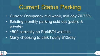
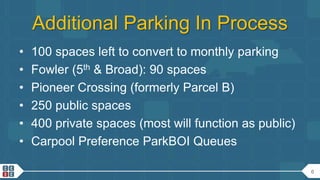
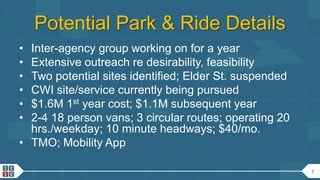
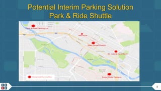
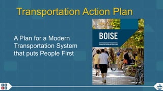
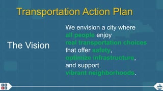
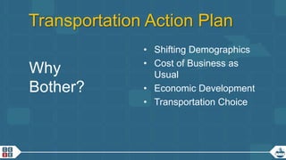
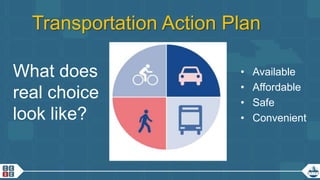
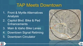
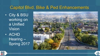
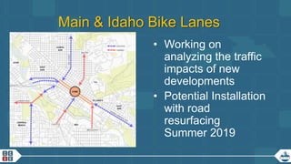
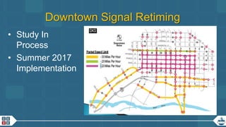
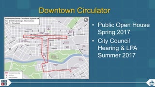
The document summarizes a study of potential streetcar routes in downtown Milwaukee. It outlines 3 potential route alignments, as well as the goals and benefits of implementing a streetcar system, including increasing transit access, supporting development, and linking key destinations. Next steps include further public meetings, technical analysis of alternatives, and identifying a preferred route to be engineered and constructed with the goal of starting operations by 2014.
CDTA is the regional mobility manager for the Capital District, operating buses, rail stations, and a bike sharing program. As the best mid-sized transit system in North America, CDTA employs 690 people and operates 17 million annual boardings across 50 bus routes and 2 train stations using its $85 million budget. CDTA works to improve mobility in the region through coordinated transit services, network design, new initiatives like bike sharing, and technology to connect different transportation options like buses and shared bicycles.
This document summarizes a panel discussion on cultivating transit-oriented communities in Connecticut and New England. The panel discussed three case studies: updating an established TOD in Stamford, CT; setting the stage for a regional center TOD in Bridgeport, CT; and a regional center TOD in motion in Somerville, MA. Key challenges discussed included lack of vision, zoning issues, infrastructure costs, and land control. The panel also addressed goals like economic development, housing, and multimodal access.
Mayor's Economic Development Commission presentationMatthew Crane
The mayor of Jasper presented on current and potential economic development projects and initiatives in the city. There are many ongoing and planned projects focused on improving infrastructure, developing a sense of place, and promoting the city. Projects include developing the downtown and riverfront areas, renovating old buildings, expanding trails and parks, conducting transportation and utility studies, and strengthening partnerships. The goal is to connect all projects and growth, avoid isolated initiatives, and continue building momentum to attract new residents and businesses to Jasper.
The Central West Focus Area Steering Committee report summarizes the committee's small area plan for development. The 17-member committee included residents and stakeholders and made decisions by consensus or 2/3 supermajority. The plan promotes walkability, bikeability, and public spaces while respecting neighborhoods. It analyzes development alternatives and their traffic and stormwater impacts. The committee gathered extensive community input through multiple public events.
This document discusses the economic benefits of placemaking and complete streets. Placemaking creates great public spaces that improve quality of life and economic development by attracting businesses and talent. Complete streets that accommodate pedestrians, bicyclists and public transit alongside vehicles make communities more livable and boost economic indicators like property values, retail sales, and development. Case studies show projects that converted roads to be more multimodal generated hundreds of millions in economic output and private investment. Walkable communities with good public spaces are shown to have higher property values.
Planning Tools for Linking Rural Development and TransportationRPO America
During the 2016 National Regional Transportation Conference, Brian Morton and John Poros described tools and analysis done for small communities in Mississippi to understand the connection between zoning, housing options, and transportation demand.
The document summarizes Atlanta's transportation plan to update its 2008 transportation plan. It discusses the plan's purpose of supporting rapid population and housing growth while relieving congestion through new funding sources. It outlines the community engagement process, including meetings, pop-ups, and online engagement to gather input. It also summarizes the plan's goals of accessibility, sustainability, and equity and the evaluation of potential transportation projects based on their ability to meet these goals in a multimodal network that focuses on alternative modes to driving.
Neil Murphy, Beyond Green
Love Cycling Go Dutch Conference
Newcastle, 5 November 2013
Workshop 4: Planning new developments - think people, think bicycle
The document summarizes the Midtown Plan, which is an urban design vision for revitalizing the Midtown area of Fort Collins, Colorado. The plan divides the Midtown corridor into three character areas - Gardens, Arts & Entertainment, and Innovation - and calls for improvements like a pedestrian promenade along MAX transit, improved intersections for safety, and a network of public spaces. The implementation strategy encourages new private investment that coordinates with public entities and utilizes financing and regulatory tools to incentivize development consistent with the plan's vision of a vibrant, transit- and pedestrian-oriented destination.
This document discusses opportunities for improved regional transit cooperation in Southern New England and the Northeast Corridor megaregion. It notes that eight of the ten densest US states are located in the Northeast Corridor. Addressing issues like traffic congestion and air pollution requires coordinating transportation planning and services across state and county lines. The document then focuses on opportunities for regional cooperation in three specific areas - Southern New England as a whole, the Knowledge Corridor region between Springfield, MA and New Haven, CT, and the metro Hartford, CT region. It discusses integrating services, fare payment, and mobility options across these regions.
RV 2014: Urban Circulator Roundtable: Shaping Cities one Challenge at a Time ...Rail~Volution
Urban Circulator Roundtable: Shaping Cities One Challenge at a Time AICP CM 1.5
An urban circulator roundtable? How appropriate! Hear speakers from around the country -- Austin; Atlanta; Minneapolis-St. Paul; Portland-- experienced in different disciplines of urban circulator implementation. Start with short presentations from each unique perspective, then focus on the challenges and issues associated with implementation -- outreach, financing, traffic, etc. -- and how each organization overcame these challenges.
Moderator: Neil McFarlane, General Manager, TriMet, Portland, Oregon
Paul Zebell, Project Manager, Bureau of Transportation, City of Portland, Oregon
April Manlapaz, Transit Project Manager, AECOM, Minneapolis, Minnesota
Derek Benedict, PE, Transportation Engineer, URS Corporation, Austin, Texas
D.J. Baxter, Executive Director, Redevelopment Agency of Salt Lake City, Salt Lake City, Utah
Jim Erkel, Attorney & Program Director, Minnesota Center for Environmental Advocacy, St. Paul, Minnesota
Lisa Gordon, Chief Operating Officer, Atlanta Beltline, Inc., Atlanta, Georgia
During the 2016 National Regional Transportation Conference, Brian Morton and John Poros described tools and analysis done for small communities in Mississippi to understand the connection between zoning, housing options, and transportation demand. This presentation serves as Part 2 of the session.
This document discusses how transportation demand management (TDM) strategies can help businesses and municipalities address transportation and economic development challenges. It provides examples of TDM strategies including parking management, pedestrian and bicycling improvements, site design, employer-based programs, and public transit. Case studies show TDM measures can reduce traffic, improve air quality, and support local economies. The document recommends partnerships, education, incentives, enforcement, funding, and collaboration to effectively implement TDM programs.
Cleveland Avenue Bus Rapid Transit Public Meeting - April 9, 2014COTA BUS
COTA is conducting preliminary design, engineering and environmental clearance for the Cleveland Avenue Bus Rapid Transit (BRT) Project. The proposed service will transport riders between downtown Columbus and Polaris Parkway/Africa Road, connect with existing bus routes, and include new stations. COTA is creating a unique identity for the proposed BRT/Enhanced Bus Service for Cleveland Avenue.
Capital Metro Transit Oriented DevelopmentCapital Metro
Manager of TOD Lucy Galbraith delivered this presentation to the Capital Metro Board of Directors Rail Committee on June 14, 2010. The presentation is a good overview of TOD and its benefits, and an update on TOD progress at four MetroRail stations.
The document discusses the challenges of aging urban expressways built in the 1950s-60s and two case studies of highway transformations in Providence, RI and Hartford, CT. It notes that many original highways are deteriorating, exceeding capacity, and failing to meet safety standards. The Providence case study outlines the replacement of I-195, which opened up 40 acres of land for development when completed in 2009. The Hartford study discusses ongoing planning to replace the aging I-84 viaduct, including alternatives considered and their projected costs. Engaging stakeholders and balancing transportation and urban design goals are emphasized as important lessons from these projects.
The document provides an overview of the Dumbarton Rail Corridor project including:
1) The roles and responsibilities of the key project partners - San Mateo County Transit District, Cross Bay Transit Partners (Facebook and Plenary Group), and regulatory agencies.
2) Updates on engineering and environmental work including potential station sites, alignment options, and key environmental topics.
3) Details on the public outreach process including recent introductory meetings and themes from community feedback.
4) The anticipated project schedule and timeline for environmental review and permitting, engineering, and construction.
India has established several national initiatives and policies to address climate change and sustainable transport, including the National Action Plan on Climate Change with eight missions, and the National Urban Transport Policy. The policies focus on integrating land use and transport planning, expanding public and non-motorized transport, and using innovations financing. However, implementing sustainable transport projects in India faces unique challenges due to factors like the dominance of two-wheelers, rising incomes encouraging personal vehicle ownership, and constraints from climate and terrain in some cities. Several cities are now working to introduce modern bus services and bus rapid transit systems, but have encountered problems due to lack of capacity and experience in planning and operating sustainable transport projects.
Chattanooga Passenger Rail Public Meeting 10/22/15 Tyler Yount
The document summarizes a public meeting held on October 22, 2015 to discuss a proposed rail transit implementation study in Chattanooga, Tennessee. The meeting agenda covered the project background, existing transit modes and technologies, examples from peer cities with rail systems, and current conditions in Chattanooga. The goals of the proposed rail project are outlined as improving economic competitiveness, sustainability, and quality of life through transportation alternatives while enhancing safety and existing infrastructure. Community input received so far indicates strong support for rail transit in Chattanooga.
Chattanooga Passenger Rail Public Meeting 1/21/16Tyler Yount
This document summarizes a public meeting for a Chattanooga Rail Implementation Study. It includes the following:
1) An agenda for the meeting covering a project overview, review of preliminary alternatives and evaluations, and next steps.
2) A summary of preliminary survey results showing support for the project and anticipated frequent use.
3) An overview of 3 preliminary rail alternatives focusing on maximizing existing infrastructure, economic development, and mobility.
4) A matrix comparing the 3 alternatives based on factors like population and jobs served, economic development potential, and activity centers connected.
5) Next steps including encouraging further public involvement and the next meeting in April to vote on recommendations.
The document provides an overview of Chapel Hill Transit, the second largest transit system in North Carolina, which serves Chapel Hill, Carrboro and UNC-Chapel Hill with 31 bus routes. It discusses plans for a proposed North-South Bus Rapid Transit system to connect the region and support growth by providing a long-term scalable transit solution. The BRT project is currently in the 60% design phase to finalize running ways and station placements along the corridor.
Reston Bike Share Feasibility Study: Public Open HouseFairfax County
The document summarizes a feasibility study examining a potential bike sharing system for Reston, Virginia. It describes bike sharing as a network of bicycles distributed around an area for short one-way trips. The study examined the viability of a 13-station, 130-bike system in Reston and identified opportunities like connections to transit and an existing bicycling culture. Key challenges included community densities, locating stations on private property, and identifying funding sources. The study concluded a bike share system was feasible for Reston if careful planning addressed issues like wayfinding, trails, access, and securing capital and operating funds.
The Bicycle Improvement Project (BIP) is a multi-phase project led by the San Angelo Metropolitan Planning Organization (SA-MPO) to create a network of shared and separated bicycle lanes totaling over 12 miles throughout San Angelo. Phase 1 of the project, which is essential to future bike projects, will connect neighborhoods, Goodfellow Air Force Base, and Angelo State University while encouraging cycling and improving safety. The project aims to improve quality of life and connect communities by providing an alternative way to access downtown San Angelo on bike, which could reduce parking needs and attract more visitors and economic activity.
Do not include any personal information as all posted material on this site is considered to be part of a public record as defined by section 27 of the Municipal Freedom of Information and Protection of Privacy Act.
We reserve the right to remove inappropriate comments. Please see Terms of Use for City of Toronto Social Media Sites at http://www.toronto.ca/e-updates/termsofuse.htm.
The First Hill Streetcar Project Update document provides information on:
1) The purpose of replacing the First Hill Light Rail Station with a streetcar line is to better connect light rail trips from the north and south to jobs and services in First Hill.
2) Sound Transit will provide up to $132.78 million for capital funding and fund operations and maintenance, while the City is responsible for design and construction and must approve the final alignment.
3) Next steps include additional analysis of potential alignments, ongoing public involvement, briefings to City committees, and a recommendation from the Mayor to City Council for a final alignment approval in April.
This document provides a conceptual multi-modal network master plan for Columbia County, GA. It includes an introduction describing the project background, approach, and goals. A community assessment analyzes the benefits of bicycling facilities and surveys community needs. The plan proposes corridor types, inventories existing facilities, and reviews current projects. It identifies priority connections and recommends collaboration and funding strategies for implementation. The goal is to create a safe, connected system of trails and lanes to accommodate the county's growing population and make it less car-dependent.
Update of Fairfax County's Transportation Priorities Plan (TPP)Fairfax County
This document provides information about Fairfax County's process to update its Transportation Priorities Plan from 2018-2023. It summarizes progress made on projects since the last update in 2014, outlines funding sources and amounts available, and describes the process for evaluating current and new project proposals using cost-benefit analysis and other criteria. Public input opportunities through online surveys and meetings are provided to help identify additional transportation needs.
The document summarizes the Memphis 3.0 Comprehensive Plan, which provides a framework to guide future growth, investment, and planning in Memphis. The plan was created through an extensive community engagement process involving over 15,000 participants. It defines "anchors" as mixed-use areas to focus growth and defines 10 street types to classify streets at different levels. The plan also outlines goals and actions around land use, connectivity, and opportunities to make Memphis a more sustainable, equitable and livable city in the coming decades.
Protected bike lanes have moved from foreign concept to best practice in U.S. design with remarkable speed (for the transportation world). This session will provide a fast paced overview of the spread of this innovation and the current state of the practice. Leaders of the Green Lane Project and our partners will cover the latest on designs, new research, best practices, analyze trends and share the best lessons from the Green Lane Project study tours.
Learning Objectives:
Participants will be able to define and identify protected bike lanes.
Participants will access peer and professional guidance on how to build a protected bike lane.
Participants will state the pros and cons of building protected bike lanes.
Participants will identify sources for additional information on building protected bike lanes.
Presenter(s)
Presenter: Martha Roskowski PeopleForBikes
Co-Presenter: Linda Bailey NACTO
Co-Presenter: Dan Goodman Office of Human Environment, Livability Team, FHWA
The document summarizes a community meeting presentation of the WCA/MPC Plan. It includes an agenda, introductions of elected officials, community organizations, and MPC representatives. Key points of the MPC report are summarized, including trends in permits and retail licenses in the WCA area and inventory of on-street parking. Recommendations from the plan are listed regarding land use, improving access and transportation, and balancing parking supply and demand. Other WCA positions and initiatives are briefly outlined. The Deputy Commissioner of Planning then discusses DPD support for components of the plan focused on encouraging growth, developer certainty, and collaboration.
This document summarizes a site plan review workshop that covered the basics of site plan review processes and an example site plan review. It included presentations from planning and engineering professionals on reviewing site plans for compliance with zoning, required site plan dimensions and features, stormwater management, landscaping, and traffic studies. The example site plan review covered existing site conditions, proposed site layout and features, public access and amenities, utilities and stormwater management, landscaping, and a traffic study review of trip generation and mitigation measures. Key takeaways stressed using outside consultants, integrating other planning processes, and developing a site plan review checklist.
Visualize 2045: Highlights from the Draft PlanFairfax County
The document provides an overview of the draft Visualize 2045 transportation plan for the Washington D.C. region. It summarizes the plan's key elements including projected population and job growth, current and planned transportation infrastructure, funding assumptions and revenues, and performance metrics. It also outlines the plan's aspirational elements which illustrate ambitious transportation improvements if more funding was available, as well as public engagement efforts to gather input on the draft plan.
Title: Not Your Grandfather's DOT: The FDOT District 5 and PennDOT Experiences
Track: Connect
Format: 90 minute moderated discussion
Abstract: Today's economic realities require the rethinking of conventional transportation approaches. Learn about how Florida and Pennsylvania's Department of Transportation are using new tools, policies, and guides to proactively plan multi-modal transportation solutions.
Presenters:
Presenter: Jane Lim-Yap Kittelson & Associates, Inc.
Co-Presenter: Steven Deck Parsons Brinckerhoff
Co-Presenter: Brian Hare PennDOT Program Center
Co-Presenter: Mary Raulerson Kittelson & Associates, Inc.
Similar to CCDC Downtown Boise Mobility Update 1-19-2017 (20)
Youngest c m in India- Pema Khandu BiographyVoterMood
Pema Khandu, born on August 21, 1979, is an Indian politician and the Chief Minister of Arunachal Pradesh. He is the son of former Chief Minister of Arunachal Pradesh, Dorjee Khandu. Pema Khandu assumed office as the Chief Minister in July 2016, making him one of the youngest Chief Ministers in India at that time.
The Biggest Threat to Western Civilization _ Andy Blumenthal _ The Blogs.pdfAndy (Avraham) Blumenthal
Article in The Times of Israel by Andy Blumenthal: China and Russia are commonly considered the biggest military threats to Western civilization, but I believe that is incorrect. The biggest strategic threat is a terrorist Jihadi Caliphate.
Acolyte Episodes review (TV series) The Acolyte. Learn about the influence of the program on the Star Wars world, as well as new characters and story twists.
Essential Tools for Modern PR Business .pptxPragencyuk
Discover the essential tools and strategies for modern PR business success. Learn how to craft compelling news releases, leverage press release sites and news wires, stay updated with PR news, and integrate effective PR practices to enhance your brand's visibility and credibility. Elevate your PR efforts with our comprehensive guide.
El Puerto de Algeciras continúa un año más como el más eficiente del continente europeo y vuelve a situarse en el “top ten” mundial, según el informe The Container Port Performance Index 2023 (CPPI), elaborado por el Banco Mundial y la consultora S&P Global.
El informe CPPI utiliza dos enfoques metodológicos diferentes para calcular la clasificación del índice: uno administrativo o técnico y otro estadístico, basado en análisis factorial (FA). Según los autores, esta dualidad pretende asegurar una clasificación que refleje con precisión el rendimiento real del puerto, a la vez que sea estadísticamente sólida. En esta edición del informe CPPI 2023, se han empleado los mismos enfoques metodológicos y se ha aplicado un método de agregación de clasificaciones para combinar los resultados de ambos enfoques y obtener una clasificación agregada.
Your Go-To Press Release Newswire for Maximum Visibility and Impact.pdfPressReleasePower4
This downloadable guide explains why press releases are still important for businesses today and the challenges you might face with traditional distribution methods. Learn how [Your Website Name] offers a comprehensive solution for crafting compelling press releases, targeting the right media outlets, and maximizing visibility.
Here is Gabe Whitley's response to my defamation lawsuit for him calling me a rapist and perjurer in court documents.
You have to read it to believe it, but after you read it, you won't believe it. And I included eight examples of defamatory statements/
5. 5
Current Status Parking
• Current Occupancy mid week, mid day 70-75%
• Existing monthly parking sold out (public &
private)
• ~500 currently on ParkBOI waitlists
• Many choosing to park hourly $12/day
6. 6
Additional Parking In Process
• 100 spaces left to convert to monthly parking
• Fowler (5th & Broad): 90 spaces
• Pioneer Crossing (formerly Parcel B)
• 250 public spaces
• 400 private spaces (most will function as public)
• Carpool Preference ParkBOI Queues
7. 7
Potential Park & Ride Details
• Inter-agency group working on for a year
• Extensive outreach re desirability, feasibility
• Two potential sites identified; Elder St. suspended
• CWI site/service currently being pursued
• $1.6M 1st year cost; $1.1M subsequent year
• 2-4 18 person vans; 3 circular routes; operating 20
hrs./weekday; 10 minute headways; $40/mo.
• TMO; Mobility App
10. 10
Transportation Action Plan
What is it?
• Boise’s Vision of a
Modern, Well-Balanced,
Transportation System
• Set of Principles &
Values
• Targeted Actions
(Moves)
• Evaluation Matrix
• Communication Tool
11. 11
Transportation Action Plan
What is it
Not?
• A Master Plan
• A Capital Improvement
Plan
• A Public Involvement
Exercise
• A Challenge to ACHD
12. 12
Transportation Action Plan
The Vision
We envision a city where
all people enjoy
real transportation choices
that offer safety,
optimize infrastructure,
and support
vibrant neighborhoods.
15. 15
TAP Meets Downtown
1. Front & Myrtle Alternatives
Analysis
2. Capitol Blvd. Bike & Ped
Enhancements
3. Main & Idaho Bike Lanes
4. Downtown Signal Retiming
5. Downtown Circulator
16. 16
Front & Myrtle Alternatives Analysis
• Approximately 30%
Complete
• Currently Focused on
Existing Conditions
Analysis & Quick Wins
• Next Phase will analyze
potential treatments
17. 17
Capitol Blvd. Bike & Ped Enhancements
• City & BSU
working on
a Unified
Vision
• ACHD
Hearing –
Spring 2017
18. 18
Main & Idaho Bike Lanes
• Working on
analyzing the traffic
impacts of new
developments
• Potential Installation
with road
resurfacing
Summer 2019