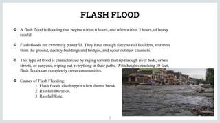
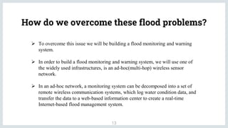
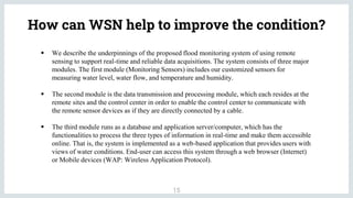
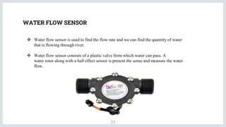
FLOOD CONTROL
INTRODUCTION
2
 Floods are the most recurring and frequent natural hazard where an area of land that get
instantly submerged in water.
 Flood may occur in many areas in different ways due to overflow of streams, rivers, lakes or
oceans or as a result of excessive rain.
 Floods can look very different because flooding covers anything from a few inches of water
to several feet. They can also come on quickly or build gradually.
TYPES OF FLOOD
3
 River Flood  Coastal Flood  Inland Flood
 Flash Flood  Storm Surge
RIVER FLOOD
4
 River flood occurs when water levels rise over the top of river banks. This flooding can happen in
all river and stream channels. This includes everything from small streams to the world’s largest
rivers.
 River floods can happen suddenly or slowly. Sudden river flooding events occur more often on
smaller rivers, rivers with steep valleys, rivers that flow for much of their length over impermeable
terrain, and normally dry channels.
 Causes of River Flooding:
1. Excessive rain from tropical storm systems making landfall.
2. Persistent thunderstorms over the same area for extended periods.
3. Combined rainfall and snowmelt.
COASTAL FLOOD
5
 A flood is a general and temporary inundation of normally dry land areas. When a
coastal process—such as waves, tides, storm surge, or heavy rainfall from coastal
storms—produces that flood.
 Coastal flooding is typically a result of a combination of sea tidal surges, high winds,
and barometric pressure.
 Causes of Coastal Flood:
1. Tropical cyclones.
2. Tsunami.
3. Higher-than-average tides.
INLAND FLOOD
6
 An inland flood is flooding that occurs inland or not in a coastal area. Therefore, coastal
flooding and storm surge are not inland floods.
 Inland floods are often worse in urban areas because there isn’t anywhere for the water to go.
 Causes of Inland Flooding:
1. Rain causes inland flooding in two ways. It can happen with steady rainfall over
several days or it can happen because of a short and intense period of rainfall.
2. Snowmelt also causes inland floods, although rainfall is a more common cause.
3. Another way inland flooding happens is when water ways get blocked by debris,
ice, or dams.
FLASH FLOOD
7
 A flash flood is flooding that begins within 6 hours, and often within 3 hours, of heavy
rainfall
 Flash floods are extremely powerful. They have enough force to roll boulders, tear trees
from the ground, destroy buildings and bridges, and scour out new channels.
 This type of flood is characterized by raging torrents that rip through river beds, urban
streets, or canyons, wiping out everything in their paths. With heights reaching 30 feet,
flash floods can completely cover communities.
 Causes of Flash Flooding:
1. Flash floods also happen when damns break.
2. Rainfall Duration.
3. Rainfall Rate.
STORM SURGE
8
 Storm Surge occurs when sea levels are elevated above the usual tidal limit due to the
action of intense low-pressure systems over the open ocean.
 Causes of Storm Surge:
1. Storm surge is always a result meteorological storms that cause higher than
normal tides on the coast.
2. Wind
3. Waves
4. Low atmospheric pressure
FLOOD CAUSES & EFFECTS
9
What Causes Flooding?
1. Heavy rainfall is the simplest cause of flooding. When there is too much rain or it happens too fast, there
just isn’t a place for it to go. This can result in floods like flash flooding.
2. Overflowing rivers are another cause of floods. You don’t necessarily need heavy rains though to
experience river flooding. As we mentioned before, river flooding can happen when there is debris in the
river or dams that block the flow of the water.
3. Channels with steep banks are also to blame for flooding. Flooding often occurs when there is fast runoff
into lakes, rivers, and other basins. This is often the case with rivers and other channels that feature steep
sides.
4. A lack of vegetation can cause flooding. Vegetation can help slow runoff and prevent flooding. When
there is a lack of vegetation, there is little to stop water from running off and overflowing river banks and
streams.
5. Broken dams are another cause of flooding. Older infrastructure can fail when heavy rains come and
water levels rise. When dams break, they unleash torrents of water on unsuspecting households.
Flooding Effects
10
 Loss of lives:
Floods kill by carrying people away in fast-moving water or drowning them. It only takes six inches of
water to wash a person away. Floods can also kill people by destroying buildings and creating unsafe
environments. One often-overlooked deadly effect of flooding comes from waterborne illnesses.
 Property Damage
Flooding also causes property damage to buildings by blowing out windows, sweeping away doors,
corroding walls and foundations, and sending debris into infrastructure at a fast pace. Not to mention
the furniture and items inside a home or business that are damaged when flood waters make it inside.
 Psychosocial Flooding Effects
Flooding can also create lasting trauma for victims. The loss of loved ones or homes can take a steep
emotional toll, especially on children. Displacement from one’s home and loss of livelihood can cause
continuing stress and produce lasting psychological impacts.
11
What causes floods in Bihar?
• There has been an increased conversion of forests to agricultural and pastoral land in the middle hills
of Nepal, which significantly contributes to the flood damage in India.
• There was a rise within the annual runoff within the Sapt Kosi from the 1950s until the 1980s, but the
rainfall also increased correspondingly at several stations within the basin.
• Another reason for the flood damage is that folks are increasingly occupying the flood plains and are
assuming that the river volume has increased to an excellent extent.
• The government has built about 3000 km of embankments, but the flow of the river has grown 2.5
times leading to the failure of embankments in every flood.
FLOOD ZONES OF BIHAR
12
How do we overcome these flood problems?
13
 To overcome this issue we will be building a flood monitoring and warning
system.
 In order to build a flood monitoring and warning system, we will use one of
the widely used infrastructures, is an ad-hoc(multi-hop) wireless sensor
network.
 In an ad-hoc network, a monitoring system can be decomposed into a set of
remote wireless communication systems, which log water condition data, and
transfer the data to a web-based information center to create a real-time
Internet-based flood management system.
WIRELESS SENOR NETWORK
14
Wireless Sensor Networks (WSNs) can be defined as a self configured wireless networks to monitor
physical or environmental conditions, such as temperature, sound, vibration, pressure, motion or pollutants
and to cooperatively pass their data through the network to a main location or sink where the data can be
observed and analyzed.
The characteristics of WSN include the following: -
1. The consumption of Power limits for nodes with batteries
2. Capacity to handle node failures
3. Some mobility of nodes and Heterogeneity of nodes
4. Scalability to a large scale of distribution
5. Capability to ensure strict environmental conditions
6. Simple to use
7. Cross-layer design
How can WSN help to improve the condition?
15
 We describe the underpinnings of the proposed flood monitoring system of using remote
sensing to support real-time and reliable data acquisitions. The system consists of three major
modules. The first module (Monitoring Sensors) includes our customized sensors for
measuring water level, water flow, and temperature and humidity.
 The second module is the data transmission and processing module, which each resides at the
remote sites and the control center in order to enable the control center to communicate with
the remote sensor devices as if they are directly connected by a cable.
 The third module runs as a database and application server/computer, which has the
functionalities to process the three types of information in real-time and make them accessible
online. That is, the system is implemented as a web-based application that provides users with
views of water conditions. End-user can access this system through a web browser (Internet)
or Mobile devices (WAP: Wireless Application Protocol).
Sensor Nodes
◍Sensor used to gather information about a physical
process(Temperature, Pressure, lights, Sound, motion, flow,
humidity, radiation etc.) and translate it into electric signals
that can be processed, measured and analyzed
◍A wireless sensor network consists of sensor nodes that are
deployed in high density and after in large quantities and
support sensing, data processing, embedded computing and
connectivity
◍WSN nodes communicate with neighboring nodes to reduce
the transmission power.
◍This is done to avoid long-distance transmission, expensive
transmitters, and repeaters
16
Architecture of Sensor Nodes
17
Architecture of Sensor Nodes
18
Sensing Unit: - It is usually composed of two sub units:
a. Sensors b. Analog digital converters.
The sensor collect the analog data from the physical world.
ADC converts this data to digital data.
Then these data/signals are fed into processing unit.
Processing Unit: - The main processing unit which is usually a microprocessor or a micro-controller,
performs an intelligent data processing & manipulation.
It is generally associated with a small storage unit.
Communication Unit: - It connects the node to the network communication unit consists of radio system
usually a short range radio for data transmission & reception.
Power unit: - As all the components are low power devices, a small battery is used to power the entire
system.
A sensor node can only be equipped with limited power source
BLOCK DIAGRAM
19
ThingSpeak
Server
Node MCU
Receiver
Node MCU
Transmitter
Water Level
Sensor
Ultrasonic
Sensor
Water Flow
Sensor
DHT11
Sensor
Buzzer
IFTTT
LED
20
NODE MCU
 We used the MCU node to monitor flood status in real-time conditions.
 This node operates as a data processing unit equipped with Wi-Fi to get internet
access.
 Data collected by the MCU node is then sent to and subsequently saved on the online
server.
 The data forwarded to the user’s smartphone to get the water level information via the
smartphone device.
THINGSPEAK WEB SERVER
21
 Thingspeak is an open source IOT application and API that allows us to aggregates,
visualization and analysis live data streams.
 ThingSpeak utilizes HTTP Convention to communicate. We can send data to
ThingSpeak from our devices and also we can use the graphs as well as numerical
display to monitor the data which is updated from sensor via internet.
 The main advantage of Thingspeak is triggering the certain link if certain conditions
are meeting.
22
IFTTT
 IFTTT stands for If This Than That. It means that if any trigger happens then the
action has to be performed.
 It is an open source web-based service that will create chains of simple conditioned
statements called applets.
 An applet creating procedure consists of 7 different steps and we need only one
operating mobile with an active sim. After completion of 7 steps successfully we get
an URL Which can be used for triggering the SMS applet.
23
SENSOR
WATER LEVEL SENSOR
 Level sensor is used to a detect the level of a substances that can flow. Such substances
like a liquids, powders, granular material and slurries.
 Level measurements can be done inside containers or it can be the level of a river or
lake.
 Such measurements can be used to determine the amount of materials within closed
container or the flow of water in open channels.
24
WATER FLOW SENSOR
 Water flow sensor is used to find the flow rate and we can find the quantity of water
that is flowing through river.
 Water flow sensor consists of a plastic valve from which water can pass. A
water rotor along with a hall effect sensor is present the sense and measure the water
flow.
DHT11 SENSOR
25
o DHT11 Sensor is used to detect both temperature and humidity in the surrounding
environment.
o It consists of a capacitive humidity sensing element and a thermistor for sensing temperature.
o For measuring temperature this sensor uses a Negative Temperature coefficient thermistor,
which causes a decreases in its resistance value with increase in temperature. To get larger
resistance value even for the smallest change in temperature.
o For measuring Humidity the capacitor has two electrodes with a moisture holding substrate as
a dielectric between them. Change in the capacitance value occurs with the change in
humidity levels.
ULTRASONIC SENSOR
26
 An ultrasonic sensor is an electronic device that measures the distance of a target object
by emitting ultrasonic sound waves, and converts the reflected sound into an electrical
signal. Ultrasonic waves travel faster than the speed of audible sound (i.e. the sound that
humans can hear).
 Ultrasonic sensors have two main components: the transmitter (which emits the sound
using piezoelectric crystals) and the receiver (which encounters the sound after it has
travelled to and from the target).
DEPLOYMENT APPROACHES
27
◍ There are two approaches for sensor deployment:
○ Deterministic Deployment: - Deterministic deployment can let sensor nodes
be placed at predetermined positions to meet all requirements, such as coverage
connectivity, expected lifetime. However, deterministic deployment are only
suitable to controllable environments, e.g. office buildings, hospitals.
○ Random Deployment: - Random deployment usually deploy more nodes and
needs more complicated sensor scheduling mechanisms. Some nodes may be
air-dropped from an air craft or be distributed in other ways, which can result in
random placement. e.g. forest, desert, battlefields.
Why deterministic deployment?
28
o In deterministic deployment , the locations of sensor are precomputed, when
their operation is significantly affected by their position.
o In contrast to random deployment, deterministic deployment provides
optimum network configuration, since positioning of sensors is determined.
o The most important metric considered is coverage, while minimizing the
usage of sensors(cost) to meet the design goal.
29
NETWORK TOPOLOGY
Star Topology: - A star network is a communications topology where a single base station can
send and/or receive a message to a number of remote nodes. The remote nodes are not permitted to
send messages to each other.
Mesh Topology: - A mesh network allows transmitting data to one node to other node in the
network that is within its radio transmission range.
Hybrid Topology: - A hybrid topology is a kind of network topology that is a combination of two
or more network topologies, such as mesh topology, bus topology, and ring topology.
Tree Topology: - Tree topology is also called as a cascaded star topology. In tree topologies,
each node connects to a node that is placed higher in the tree, and then to the gateway.
30
HYBRID STAR-MESH TOPOLOGY
 A hybrid between the star and mesh network provides a robust and versatile
communications network, while maintaining the ability to keep the wireless sensor nodes
power consumption to a minimum.
 In this network topology, the sensor nodes with lowest power are not enabled with the ability
to forward messages. This allows for minimal power consumption to be maintained.
 Other nodes on the network are enabled with multi-hop capability, allowing them to forward
messages from the low power nodes to other nodes on the network.
WSN ARCHITECTURE
31
The architecture used in WSN is sensor network architecture. This kind of architecture is applicable in different
places such as hospitals, schools, roads, buildings as well as it is used in different applications such as security
management, disaster management & crisis management, etc.
There are 2 types of wireless sensor architectures:
• Layered Network Architecture
•Clustered Network Architecture
Layered Network Architecture
This kind of network uses hundreds of sensor nodes as well as a base station. Here the arrangement of network
nodes can be done into concentric layers. It comprises five layers as well as 3 cross layers which include the
following.
The five layers in the architecture are:
•Application Layer
•Transport Layer
•Network Layer
•Data Link Layer
•Physical Layer
Clustered Network Architecture
In this kind of architecture, separately sensor nodes add into groups known as clusters which depend on the
“Leach Protocol” because it uses clusters.
The main properties of this protocol mainly include the following:-
1. This is a two-tier hierarchy clustering architecture.
2. This distributed algorithm is used to arrange the sensor nodes into groups, known as clusters.
3. In every cluster which is formed separately, the head nodes of the cluster will create the TDMA (Time-
division multiple access) plans.
4. It uses the Data Fusion concept so that it will make the network energy efficient.
This kind of network architecture is extremely used due to the data fusion property. In every cluster, every node
can interact through the head of the cluster to get the data. All the clusters will share their collected data toward
the base station.
32
ROUTING PROTOCOLS FOR WSN
33
 The routing protocol is a process to select suitable path for the data to travel from source
to destination.
 The data sensed by the sensor nodes in a wireless sensor network (WSN) is typically forwarded to the
base station that connects the sensor network with the other networks where the data is collected,
analyzed and some action is taken accordingly.
 In very small sensor networks where the base station and sensor nodes so close that they can
communicate directly with each other than this is single-hop communication but in most WSN
application the coverage area is so large that requires thousands of nodes to be placed and this scenario
requires multi-hop communication.
 In multi-hop communication the sensor nodes not only produce and deliver their material but also serve
as a path for other sensor nodes towards the base station.
LEACH PROTOCOL
34
Low-energy adaptive clustering hierarchy (LEACH) is a routing algorithm designed to collect and deliver
data to the data sink, typically a base station.
The main objectives of LEACH are: -
o Extension of the network lifetime
o Reduced energy consumption by each network sensor node
o Use of data aggregation to reduce the number of communication messages
Why LEACH Protocol?
35
 LEACH is a routing protocol that organizes the cluster such that the energy is equally divided in
all the sensor nodes in the network.
 In LEACH protocol several clusters are produced of sensor nodes and one node defined as cluster
head and act as routing node for all the other nodes in the cluster.
 LEACH protocol apply randomization and cluster head is selected from the group of nodes so
this selection of cluster head from several nodes on temporary basis make this protocol more long
lasting as battery of a single node is not burdened for long.
 Sensor nodes elect themselves as cluster head with some probability criteria defined by the
protocol and announce this to other nodes
CONCLUSION
36
 Flooding is a perennial problem in the state of Bihar with devastating impact on the livelihood of
people. The effects of damages to life and property caused by flooding were severe for several
years. The damage to infrastructure also badly affects the industry sector.
 The conclusion of this case study is that to create prototype that can detect water levels and send
information to a smartphone by giving a notification message or sending a message via email.
 The tests with different water levels show that the application indicators operate properly, obtaining
an accuracy rate.
 This prototype can provide correct information about water levels. We expect that the prototype and
the proposed method can contribute to IoT applications in the field of disaster response systems.
 The system is subject to more comprehensive study and simulation to evaluate it is efficiency in
early flood prediction in real-time.
REFERENCES
37
[1] "Gambar Umum Kota Makassar” Rencana Pembangunan Jangka Menengah Daerah Kota
Makassar Tahun 2014-2019
[2] “Geografi Regional Indonesia” Jurusan Pendidikan Geografi Fakultas Ilmu
Pengetahuan Sosial Universitas Pendidikan Indonesia 2008.
[3] J. Sunkpho and C. Ootamakorn“ Real-time flood monitoring and warning system.”
Songklanakarin Journal Science and Technology. 33 (2), 227-235, 2011
[4] “ Flood Detection using Sensor Network and Notification via SMS and Public Network
5.pdf.” .
[5] Hughes, D., Greenwood, P., et al.: An intelligent and adaptable grid-based flood monitoring
and warning system. Citeseer (2006)
Thank You!
38
PRESENTED BY:
ASHISH THAPA

Case study flood control (wsn)

  • 1.
  • 2.
    INTRODUCTION 2  Floods arethe most recurring and frequent natural hazard where an area of land that get instantly submerged in water.  Flood may occur in many areas in different ways due to overflow of streams, rivers, lakes or oceans or as a result of excessive rain.  Floods can look very different because flooding covers anything from a few inches of water to several feet. They can also come on quickly or build gradually.
  • 3.
    TYPES OF FLOOD 3 River Flood  Coastal Flood  Inland Flood  Flash Flood  Storm Surge
  • 4.
    RIVER FLOOD 4  Riverflood occurs when water levels rise over the top of river banks. This flooding can happen in all river and stream channels. This includes everything from small streams to the world’s largest rivers.  River floods can happen suddenly or slowly. Sudden river flooding events occur more often on smaller rivers, rivers with steep valleys, rivers that flow for much of their length over impermeable terrain, and normally dry channels.  Causes of River Flooding: 1. Excessive rain from tropical storm systems making landfall. 2. Persistent thunderstorms over the same area for extended periods. 3. Combined rainfall and snowmelt.
  • 5.
    COASTAL FLOOD 5  Aflood is a general and temporary inundation of normally dry land areas. When a coastal process—such as waves, tides, storm surge, or heavy rainfall from coastal storms—produces that flood.  Coastal flooding is typically a result of a combination of sea tidal surges, high winds, and barometric pressure.  Causes of Coastal Flood: 1. Tropical cyclones. 2. Tsunami. 3. Higher-than-average tides.
  • 6.
    INLAND FLOOD 6  Aninland flood is flooding that occurs inland or not in a coastal area. Therefore, coastal flooding and storm surge are not inland floods.  Inland floods are often worse in urban areas because there isn’t anywhere for the water to go.  Causes of Inland Flooding: 1. Rain causes inland flooding in two ways. It can happen with steady rainfall over several days or it can happen because of a short and intense period of rainfall. 2. Snowmelt also causes inland floods, although rainfall is a more common cause. 3. Another way inland flooding happens is when water ways get blocked by debris, ice, or dams.
  • 7.
    FLASH FLOOD 7  Aflash flood is flooding that begins within 6 hours, and often within 3 hours, of heavy rainfall  Flash floods are extremely powerful. They have enough force to roll boulders, tear trees from the ground, destroy buildings and bridges, and scour out new channels.  This type of flood is characterized by raging torrents that rip through river beds, urban streets, or canyons, wiping out everything in their paths. With heights reaching 30 feet, flash floods can completely cover communities.  Causes of Flash Flooding: 1. Flash floods also happen when damns break. 2. Rainfall Duration. 3. Rainfall Rate.
  • 8.
    STORM SURGE 8  StormSurge occurs when sea levels are elevated above the usual tidal limit due to the action of intense low-pressure systems over the open ocean.  Causes of Storm Surge: 1. Storm surge is always a result meteorological storms that cause higher than normal tides on the coast. 2. Wind 3. Waves 4. Low atmospheric pressure
  • 9.
    FLOOD CAUSES &EFFECTS 9 What Causes Flooding? 1. Heavy rainfall is the simplest cause of flooding. When there is too much rain or it happens too fast, there just isn’t a place for it to go. This can result in floods like flash flooding. 2. Overflowing rivers are another cause of floods. You don’t necessarily need heavy rains though to experience river flooding. As we mentioned before, river flooding can happen when there is debris in the river or dams that block the flow of the water. 3. Channels with steep banks are also to blame for flooding. Flooding often occurs when there is fast runoff into lakes, rivers, and other basins. This is often the case with rivers and other channels that feature steep sides. 4. A lack of vegetation can cause flooding. Vegetation can help slow runoff and prevent flooding. When there is a lack of vegetation, there is little to stop water from running off and overflowing river banks and streams. 5. Broken dams are another cause of flooding. Older infrastructure can fail when heavy rains come and water levels rise. When dams break, they unleash torrents of water on unsuspecting households.
  • 10.
    Flooding Effects 10  Lossof lives: Floods kill by carrying people away in fast-moving water or drowning them. It only takes six inches of water to wash a person away. Floods can also kill people by destroying buildings and creating unsafe environments. One often-overlooked deadly effect of flooding comes from waterborne illnesses.  Property Damage Flooding also causes property damage to buildings by blowing out windows, sweeping away doors, corroding walls and foundations, and sending debris into infrastructure at a fast pace. Not to mention the furniture and items inside a home or business that are damaged when flood waters make it inside.  Psychosocial Flooding Effects Flooding can also create lasting trauma for victims. The loss of loved ones or homes can take a steep emotional toll, especially on children. Displacement from one’s home and loss of livelihood can cause continuing stress and produce lasting psychological impacts.
  • 11.
    11 What causes floodsin Bihar? • There has been an increased conversion of forests to agricultural and pastoral land in the middle hills of Nepal, which significantly contributes to the flood damage in India. • There was a rise within the annual runoff within the Sapt Kosi from the 1950s until the 1980s, but the rainfall also increased correspondingly at several stations within the basin. • Another reason for the flood damage is that folks are increasingly occupying the flood plains and are assuming that the river volume has increased to an excellent extent. • The government has built about 3000 km of embankments, but the flow of the river has grown 2.5 times leading to the failure of embankments in every flood.
  • 12.
  • 13.
    How do weovercome these flood problems? 13  To overcome this issue we will be building a flood monitoring and warning system.  In order to build a flood monitoring and warning system, we will use one of the widely used infrastructures, is an ad-hoc(multi-hop) wireless sensor network.  In an ad-hoc network, a monitoring system can be decomposed into a set of remote wireless communication systems, which log water condition data, and transfer the data to a web-based information center to create a real-time Internet-based flood management system.
  • 14.
    WIRELESS SENOR NETWORK 14 WirelessSensor Networks (WSNs) can be defined as a self configured wireless networks to monitor physical or environmental conditions, such as temperature, sound, vibration, pressure, motion or pollutants and to cooperatively pass their data through the network to a main location or sink where the data can be observed and analyzed. The characteristics of WSN include the following: - 1. The consumption of Power limits for nodes with batteries 2. Capacity to handle node failures 3. Some mobility of nodes and Heterogeneity of nodes 4. Scalability to a large scale of distribution 5. Capability to ensure strict environmental conditions 6. Simple to use 7. Cross-layer design
  • 15.
    How can WSNhelp to improve the condition? 15  We describe the underpinnings of the proposed flood monitoring system of using remote sensing to support real-time and reliable data acquisitions. The system consists of three major modules. The first module (Monitoring Sensors) includes our customized sensors for measuring water level, water flow, and temperature and humidity.  The second module is the data transmission and processing module, which each resides at the remote sites and the control center in order to enable the control center to communicate with the remote sensor devices as if they are directly connected by a cable.  The third module runs as a database and application server/computer, which has the functionalities to process the three types of information in real-time and make them accessible online. That is, the system is implemented as a web-based application that provides users with views of water conditions. End-user can access this system through a web browser (Internet) or Mobile devices (WAP: Wireless Application Protocol).
  • 16.
    Sensor Nodes ◍Sensor usedto gather information about a physical process(Temperature, Pressure, lights, Sound, motion, flow, humidity, radiation etc.) and translate it into electric signals that can be processed, measured and analyzed ◍A wireless sensor network consists of sensor nodes that are deployed in high density and after in large quantities and support sensing, data processing, embedded computing and connectivity ◍WSN nodes communicate with neighboring nodes to reduce the transmission power. ◍This is done to avoid long-distance transmission, expensive transmitters, and repeaters 16
  • 17.
  • 18.
    Architecture of SensorNodes 18 Sensing Unit: - It is usually composed of two sub units: a. Sensors b. Analog digital converters. The sensor collect the analog data from the physical world. ADC converts this data to digital data. Then these data/signals are fed into processing unit. Processing Unit: - The main processing unit which is usually a microprocessor or a micro-controller, performs an intelligent data processing & manipulation. It is generally associated with a small storage unit. Communication Unit: - It connects the node to the network communication unit consists of radio system usually a short range radio for data transmission & reception. Power unit: - As all the components are low power devices, a small battery is used to power the entire system. A sensor node can only be equipped with limited power source
  • 19.
    BLOCK DIAGRAM 19 ThingSpeak Server Node MCU Receiver NodeMCU Transmitter Water Level Sensor Ultrasonic Sensor Water Flow Sensor DHT11 Sensor Buzzer IFTTT LED
  • 20.
    20 NODE MCU  Weused the MCU node to monitor flood status in real-time conditions.  This node operates as a data processing unit equipped with Wi-Fi to get internet access.  Data collected by the MCU node is then sent to and subsequently saved on the online server.  The data forwarded to the user’s smartphone to get the water level information via the smartphone device.
  • 21.
    THINGSPEAK WEB SERVER 21 Thingspeak is an open source IOT application and API that allows us to aggregates, visualization and analysis live data streams.  ThingSpeak utilizes HTTP Convention to communicate. We can send data to ThingSpeak from our devices and also we can use the graphs as well as numerical display to monitor the data which is updated from sensor via internet.  The main advantage of Thingspeak is triggering the certain link if certain conditions are meeting.
  • 22.
    22 IFTTT  IFTTT standsfor If This Than That. It means that if any trigger happens then the action has to be performed.  It is an open source web-based service that will create chains of simple conditioned statements called applets.  An applet creating procedure consists of 7 different steps and we need only one operating mobile with an active sim. After completion of 7 steps successfully we get an URL Which can be used for triggering the SMS applet.
  • 23.
    23 SENSOR WATER LEVEL SENSOR Level sensor is used to a detect the level of a substances that can flow. Such substances like a liquids, powders, granular material and slurries.  Level measurements can be done inside containers or it can be the level of a river or lake.  Such measurements can be used to determine the amount of materials within closed container or the flow of water in open channels.
  • 24.
    24 WATER FLOW SENSOR Water flow sensor is used to find the flow rate and we can find the quantity of water that is flowing through river.  Water flow sensor consists of a plastic valve from which water can pass. A water rotor along with a hall effect sensor is present the sense and measure the water flow.
  • 25.
    DHT11 SENSOR 25 o DHT11Sensor is used to detect both temperature and humidity in the surrounding environment. o It consists of a capacitive humidity sensing element and a thermistor for sensing temperature. o For measuring temperature this sensor uses a Negative Temperature coefficient thermistor, which causes a decreases in its resistance value with increase in temperature. To get larger resistance value even for the smallest change in temperature. o For measuring Humidity the capacitor has two electrodes with a moisture holding substrate as a dielectric between them. Change in the capacitance value occurs with the change in humidity levels.
  • 26.
    ULTRASONIC SENSOR 26  Anultrasonic sensor is an electronic device that measures the distance of a target object by emitting ultrasonic sound waves, and converts the reflected sound into an electrical signal. Ultrasonic waves travel faster than the speed of audible sound (i.e. the sound that humans can hear).  Ultrasonic sensors have two main components: the transmitter (which emits the sound using piezoelectric crystals) and the receiver (which encounters the sound after it has travelled to and from the target).
  • 27.
    DEPLOYMENT APPROACHES 27 ◍ Thereare two approaches for sensor deployment: ○ Deterministic Deployment: - Deterministic deployment can let sensor nodes be placed at predetermined positions to meet all requirements, such as coverage connectivity, expected lifetime. However, deterministic deployment are only suitable to controllable environments, e.g. office buildings, hospitals. ○ Random Deployment: - Random deployment usually deploy more nodes and needs more complicated sensor scheduling mechanisms. Some nodes may be air-dropped from an air craft or be distributed in other ways, which can result in random placement. e.g. forest, desert, battlefields.
  • 28.
    Why deterministic deployment? 28 oIn deterministic deployment , the locations of sensor are precomputed, when their operation is significantly affected by their position. o In contrast to random deployment, deterministic deployment provides optimum network configuration, since positioning of sensors is determined. o The most important metric considered is coverage, while minimizing the usage of sensors(cost) to meet the design goal.
  • 29.
    29 NETWORK TOPOLOGY Star Topology:- A star network is a communications topology where a single base station can send and/or receive a message to a number of remote nodes. The remote nodes are not permitted to send messages to each other. Mesh Topology: - A mesh network allows transmitting data to one node to other node in the network that is within its radio transmission range. Hybrid Topology: - A hybrid topology is a kind of network topology that is a combination of two or more network topologies, such as mesh topology, bus topology, and ring topology. Tree Topology: - Tree topology is also called as a cascaded star topology. In tree topologies, each node connects to a node that is placed higher in the tree, and then to the gateway.
  • 30.
    30 HYBRID STAR-MESH TOPOLOGY A hybrid between the star and mesh network provides a robust and versatile communications network, while maintaining the ability to keep the wireless sensor nodes power consumption to a minimum.  In this network topology, the sensor nodes with lowest power are not enabled with the ability to forward messages. This allows for minimal power consumption to be maintained.  Other nodes on the network are enabled with multi-hop capability, allowing them to forward messages from the low power nodes to other nodes on the network.
  • 31.
    WSN ARCHITECTURE 31 The architectureused in WSN is sensor network architecture. This kind of architecture is applicable in different places such as hospitals, schools, roads, buildings as well as it is used in different applications such as security management, disaster management & crisis management, etc. There are 2 types of wireless sensor architectures: • Layered Network Architecture •Clustered Network Architecture Layered Network Architecture This kind of network uses hundreds of sensor nodes as well as a base station. Here the arrangement of network nodes can be done into concentric layers. It comprises five layers as well as 3 cross layers which include the following. The five layers in the architecture are: •Application Layer •Transport Layer •Network Layer •Data Link Layer •Physical Layer
  • 32.
    Clustered Network Architecture Inthis kind of architecture, separately sensor nodes add into groups known as clusters which depend on the “Leach Protocol” because it uses clusters. The main properties of this protocol mainly include the following:- 1. This is a two-tier hierarchy clustering architecture. 2. This distributed algorithm is used to arrange the sensor nodes into groups, known as clusters. 3. In every cluster which is formed separately, the head nodes of the cluster will create the TDMA (Time- division multiple access) plans. 4. It uses the Data Fusion concept so that it will make the network energy efficient. This kind of network architecture is extremely used due to the data fusion property. In every cluster, every node can interact through the head of the cluster to get the data. All the clusters will share their collected data toward the base station. 32
  • 33.
    ROUTING PROTOCOLS FORWSN 33  The routing protocol is a process to select suitable path for the data to travel from source to destination.  The data sensed by the sensor nodes in a wireless sensor network (WSN) is typically forwarded to the base station that connects the sensor network with the other networks where the data is collected, analyzed and some action is taken accordingly.  In very small sensor networks where the base station and sensor nodes so close that they can communicate directly with each other than this is single-hop communication but in most WSN application the coverage area is so large that requires thousands of nodes to be placed and this scenario requires multi-hop communication.  In multi-hop communication the sensor nodes not only produce and deliver their material but also serve as a path for other sensor nodes towards the base station.
  • 34.
    LEACH PROTOCOL 34 Low-energy adaptiveclustering hierarchy (LEACH) is a routing algorithm designed to collect and deliver data to the data sink, typically a base station. The main objectives of LEACH are: - o Extension of the network lifetime o Reduced energy consumption by each network sensor node o Use of data aggregation to reduce the number of communication messages
  • 35.
    Why LEACH Protocol? 35 LEACH is a routing protocol that organizes the cluster such that the energy is equally divided in all the sensor nodes in the network.  In LEACH protocol several clusters are produced of sensor nodes and one node defined as cluster head and act as routing node for all the other nodes in the cluster.  LEACH protocol apply randomization and cluster head is selected from the group of nodes so this selection of cluster head from several nodes on temporary basis make this protocol more long lasting as battery of a single node is not burdened for long.  Sensor nodes elect themselves as cluster head with some probability criteria defined by the protocol and announce this to other nodes
  • 36.
    CONCLUSION 36  Flooding isa perennial problem in the state of Bihar with devastating impact on the livelihood of people. The effects of damages to life and property caused by flooding were severe for several years. The damage to infrastructure also badly affects the industry sector.  The conclusion of this case study is that to create prototype that can detect water levels and send information to a smartphone by giving a notification message or sending a message via email.  The tests with different water levels show that the application indicators operate properly, obtaining an accuracy rate.  This prototype can provide correct information about water levels. We expect that the prototype and the proposed method can contribute to IoT applications in the field of disaster response systems.  The system is subject to more comprehensive study and simulation to evaluate it is efficiency in early flood prediction in real-time.
  • 37.
    REFERENCES 37 [1] "Gambar UmumKota Makassar” Rencana Pembangunan Jangka Menengah Daerah Kota Makassar Tahun 2014-2019 [2] “Geografi Regional Indonesia” Jurusan Pendidikan Geografi Fakultas Ilmu Pengetahuan Sosial Universitas Pendidikan Indonesia 2008. [3] J. Sunkpho and C. Ootamakorn“ Real-time flood monitoring and warning system.” Songklanakarin Journal Science and Technology. 33 (2), 227-235, 2011 [4] “ Flood Detection using Sensor Network and Notification via SMS and Public Network 5.pdf.” . [5] Hughes, D., Greenwood, P., et al.: An intelligent and adaptable grid-based flood monitoring and warning system. Citeseer (2006)
  • 38.