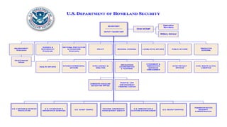
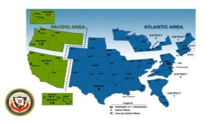
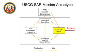
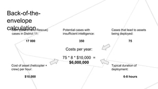
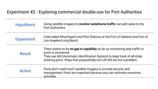
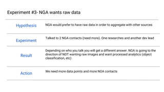
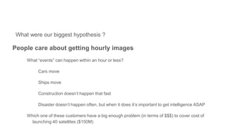
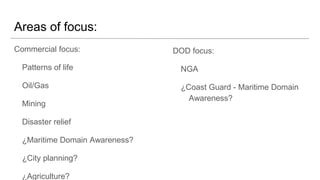
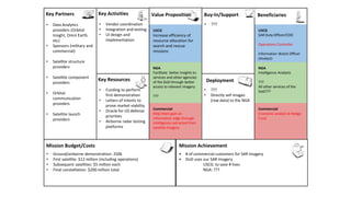
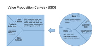
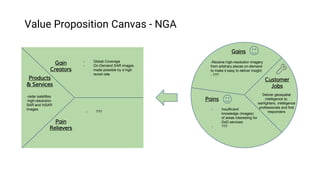
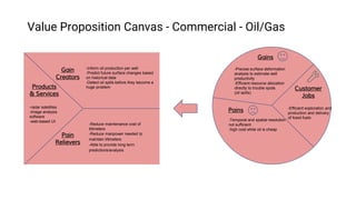
Capella Space
We are providing low-cost SAR imagery satellite constellation with a high revisit rate.
Payam Banazadeh
Aerospace/Business
Timon Ruban
Machine Learning
Isaac Matthews
Aerospace
Jose Ignacio del Villar
Business
# interviews
this week:
6 users
0 buyers
4 experts
# total
interviews:
60
Redacted
Redacted
Redacted
Redacted
Redacted
Redacted
Redacted
Redacted Redacted
Redacted Redacted
Redacted Redacted
Redacted
Redacted
Redacted
Redacted
USCG SAR Mission Archetype
Command
Duty Officer
Law
Enforcement
Duty Officer
Intelligence
Analyst
Watch Officer
SAR Duty
Officer
SAR
Mission
Commander
Emergency
Notification RFI
Redacted
Redacted
Redacted
Experiment #1 - Understanding the scope of USCG’s problem
Hypothesis
Experiment
Result
Action
There is a major economic need for the USCG to adopt more detailed reconnaissance
systems
Visited the USCG’s 11th district command center in Alameda, and talked to many
other members of the USCG
Through our conversations it did not seem clear to us that providing more detailed
reconnaissance systems to the USCG is a pressing need for them. Even though they
might benefit from having that system, the economic gains are not perceived to be
large enough to support our thesis.
We will try to keep in contact with the USCG to dig deeper on the problems they
have, but we won’t make it our priority.
Redacted
Reda
cted
Redacted
Redacted
Redacted
Redacted
Red
acte
d
Back-of-the-
envelope
calculationS&R (Search and Rescue)
cases in District 11:
17 000
Potential cases with
insufficient intelligence:
350
Cases that lead to assets
being deployed:
75
Typical duration of
deployment:
6-8 hours
Cost of asset (helicopter +
crew) per hour:
$10,000
Costs per year:
75 * 8 * $10,000 =
$6,000,000
Redacted
Redacted
Redacted
Redacted
Redacted
Redacted
Redacted
Redacted
Experiment #2 - Exploring commercial double-use for Port Authorities
Hypothesis
Experiment
Result
Action
Using satellite imagery to monitor waterborne traffic can add value to the Port
Authorities
Cold-called Wharfingers and Pilot Stations at the Port of Oakland and Port of Los
Angeles/Long Beach
There seems to be no gap in capability as far as monitoring ship traffic in ports is
concerned.
They use AIS (Automatic Identification System) to keep track of all ships entering
ports. Ships that purposefully turn off AIS are not a problem.
Ports don’t need much satellite imagery to provide security and management. Ports
are important because you can estimate economic activities
Redacted
Redacted
Redacted
Redacted
Redacted
Redacted
Redacted
Redacted
Redacted
Experiment #3- NGA wants raw data
Hypothesis
Experiment
Result
Action
NGA would prefer to have raw data in order to aggregate with other sources
Talked to 2 NGA contacts (need more). One researches and another dev lead
Depending on who you talk you will get a different answer. NGA is going to the
direction of NOT wanting raw images and want processed analytics (object
classification, etc)
We need more data points and more NGA contacts
Redacted
Redacted
Redacted
Redacted
Redacted
Red
acte
d
What were our biggest hypothesis ?
People care about getting hourly images
What “events” can happen within an hour or less?
Cars move
Ships move
Construction doesn’t happen that fast
Disaster doesn’t happen often, but when it does it’s important to get intelligence ASAP
Which one of these customers have a big enough problem (in terms of $$$) to cover cost of
launching 40 satellites ($150M)
?????????
Redacted
Redacted
Areas of focus:
Commercial focus:
Patterns of life
Oil/Gas
Mining
Disaster relief
Maritime Domain Awareness?
City planning?
Agriculture?
Construction?
DOD focus:
NGA
Coast Guard - Maritime Domain
Awareness?
Redacted
Redacted
• Deploy	1	to	3	satellites	
and	sell	the	images	by	
September	2017.
• Finish	the	deployment	
of	40	satellites	by	
2020.
• Construction	of	
payload	for	testing
• Development	of	image	
analysis	algorithms
• Construction	of	
satellite	under	
required	constraints
• Data	Analytics	
providers	(Orbital	
Insight,	Omni	Earth,	
etc)
• Sponsors	(military	and	
commercial)
• Satellite	structure	
providers
• Satellite	component	
providers	
• Orbital	
communication	
providers
• Satellite	launch	
providers
• Get	a	customer	in	a	country	in	the	Equatorial	orbit	
(Government)
• Get	commercial	customers	interested	enough	in	our	tech
• The	DHS	and	other	government	departments	adopt	our	
technology:
• - USCG:	to	thwart	drug	trafficking	from	Ecuador	and	Colombia
• Summer	ground	demonstration:	$50k
• First	satellite:	$6	million	(including	operations)
• Subsequent	satellites:	$3	million	each
• Final	constellation:	$150	million	total	over	3	years	
• Funding	to	perform	
payload	test	during	
Summer	2016
• Government	advocacy	
for	our	technology:	
DHS
• Contacts	in	the	
Equatorial	countries’	
government	agencies.
Beneficiaries
Mission	AchievementMission	Budget/Costs
Buy-In/Support
Deployment
Value	PropositionKey	Activities
Key	Resources
Commercial
Satellite	imagery	resellers
Illegal	fishing	in	Indonesia
Oil	tankering	in	Nigeria
Stop	pirating	at	sea	in	
Somalia
Key	Partners
USCG
Law	Enforcement	DO	
Information	Watch	Officer
USCG
- Stop	more	boats	carrying	
drugs	from	
Ecuador/Colombia
- Reduce	the	cost	of	drug	
intervention	operations
NGA
Provide	better	intelligence	
to	other	agencies/services
Commercial
Satellite	Imagery	Resellers:	
they	can	offer	better	and	
more	diverse	products
Illegal	fishing:	tracking	of	
ships	that	are	doing	
suspicious	activities	at	sea.	
Better	law	enforcement.
NGA
Intelligence	Analysts
Services	in	the	DoD??
SOCOM
Government	sector	driving	
demand	(Indonesia,	Nigeria,	
Ecuador,	Colombia)
Coast	Guard	Deputy	
Commandant	for	
Operations	(CG-DCO)
Redacted
Redacted
Redacted Redacted
Redacted
Redacted Redacted
Redacted
Redacted
Products
& Services
Run	counter-drug
Operations
Catch	“bad	guys	on	
boats”
Customer
Jobs
- “The sea is vast”
-Low budget (=> cannot
deploy to many resources)
-Hard to know where to
look/patrol
Gains
Pains
Gain
Creators
Pain
Relievers
-Information on where boats are
in patrol area lets duty officers
deploy assets more
strategically and more
efficiently
-High revisit rate enables duty
officers to see smugglers even
on quick runs (3-5h)
- Stop	more	boats	carrying	drugs	
from	Ecuador/Colombia
- Reduce	the	cost	of	drug	
intervention	operations
Value Proposition Canvas - USCG Law Enforcement DO
-provide locations of
boats without AIS in
desired area (extracted
from SAR images)
-web-based UI
-modern machine
learning/computer vision
techniques can scan many
images for boats and cover
vast areas
-locations of boats without
AIS can queue where to
send patrol vessels/aircrafts
Redacted
Redacted
Redacted
Redacted
Redacted
Redacted
Redacted
Products
& Services
Deliver geospatial
intelligence to,
warfighters, intelligence
professionals and first
responders
Customer
Jobs
- Insufficient
knowledge (images)
of areas interesting for
DoD services
- Over-tasking of analysts
- Backlog of un-extruded
data
Gains
Pains
Gain
Creators
Pain
Relievers
- Global Coverage
- On-Demand SAR images
made possible by a high
revisit rate
- Data conditioning
alleviates analyst
tasking
- Extrusions may align
with current tagging
practices
-Receive high-resolution imagery
from arbitrary places on-demand
to make it easy to deliver insight
- ???
Value Proposition Canvas - NGA
-radar satellites
-high-resolution
SAR and InSAR
images
Redacted
Redacted
Redacted
Redacted
Redacted
Redacted
Redacted
Products
& Services
-Efficient exploration and
production and delivery
of fossil fuels
Customer
Jobs
-Temporal and spatial resolution
not sufficient
-high cost while oil is cheap
Gains
Pains
Gain
Creators
Pain
Relievers
-Inform oil production per well
-Predict future surface changes based
on historical data
-Detect oil spills before they become a
huge problem
-Reduce maintenance cost of
tiltmeters
-Reduce manpower needed to
maintain tiltmeters
-Able to provide long term
predictions/analysis
-Precise surface deformation
analysis to estimate well
productivity
-Efficient resource allocation
directly to trouble spots
(oil spills)
Value Proposition Canvas - Commercial - Hedge Fund
Investors, Oil/Mining, Agriculture
-radar satellites
-image analysis
software
-web-based UI
Redacted
Redacted
Redacted
Redacted
Redacted
Redacted
Redacted
Redacted
Additional Slides
……
US Coast Guard Organization
CANT
D 1
D 2 D 7 D 11
COMDT
Redacted
Redacted
Redacted

Capella Space Week 5 H4D Stanford 2016

  • 1.
    Capella Space We areproviding low-cost SAR imagery satellite constellation with a high revisit rate. Payam Banazadeh Aerospace/Business Timon Ruban Machine Learning Isaac Matthews Aerospace Jose Ignacio del Villar Business # interviews this week: 6 users 0 buyers 4 experts # total interviews: 60 Redacted
  • 3.
  • 4.
  • 5.
    USCG SAR MissionArchetype Command Duty Officer Law Enforcement Duty Officer Intelligence Analyst Watch Officer SAR Duty Officer SAR Mission Commander Emergency Notification RFI Redacted Redacted Redacted
  • 6.
    Experiment #1 -Understanding the scope of USCG’s problem Hypothesis Experiment Result Action There is a major economic need for the USCG to adopt more detailed reconnaissance systems Visited the USCG’s 11th district command center in Alameda, and talked to many other members of the USCG Through our conversations it did not seem clear to us that providing more detailed reconnaissance systems to the USCG is a pressing need for them. Even though they might benefit from having that system, the economic gains are not perceived to be large enough to support our thesis. We will try to keep in contact with the USCG to dig deeper on the problems they have, but we won’t make it our priority. Redacted Reda cted Redacted Redacted Redacted Redacted Red acte d
  • 7.
    Back-of-the- envelope calculationS&R (Search andRescue) cases in District 11: 17 000 Potential cases with insufficient intelligence: 350 Cases that lead to assets being deployed: 75 Typical duration of deployment: 6-8 hours Cost of asset (helicopter + crew) per hour: $10,000 Costs per year: 75 * 8 * $10,000 = $6,000,000 Redacted Redacted Redacted Redacted Redacted Redacted Redacted Redacted
  • 8.
    Experiment #2 -Exploring commercial double-use for Port Authorities Hypothesis Experiment Result Action Using satellite imagery to monitor waterborne traffic can add value to the Port Authorities Cold-called Wharfingers and Pilot Stations at the Port of Oakland and Port of Los Angeles/Long Beach There seems to be no gap in capability as far as monitoring ship traffic in ports is concerned. They use AIS (Automatic Identification System) to keep track of all ships entering ports. Ships that purposefully turn off AIS are not a problem. Ports don’t need much satellite imagery to provide security and management. Ports are important because you can estimate economic activities Redacted Redacted Redacted Redacted Redacted Redacted Redacted Redacted Redacted
  • 9.
    Experiment #3- NGAwants raw data Hypothesis Experiment Result Action NGA would prefer to have raw data in order to aggregate with other sources Talked to 2 NGA contacts (need more). One researches and another dev lead Depending on who you talk you will get a different answer. NGA is going to the direction of NOT wanting raw images and want processed analytics (object classification, etc) We need more data points and more NGA contacts Redacted Redacted Redacted Redacted Redacted Red acte d
  • 10.
    What were ourbiggest hypothesis ? People care about getting hourly images What “events” can happen within an hour or less? Cars move Ships move Construction doesn’t happen that fast Disaster doesn’t happen often, but when it does it’s important to get intelligence ASAP Which one of these customers have a big enough problem (in terms of $$$) to cover cost of launching 40 satellites ($150M) ????????? Redacted Redacted
  • 11.
    Areas of focus: Commercialfocus: Patterns of life Oil/Gas Mining Disaster relief Maritime Domain Awareness? City planning? Agriculture? Construction? DOD focus: NGA Coast Guard - Maritime Domain Awareness? Redacted Redacted
  • 12.
    • Deploy 1 to 3 satellites and sell the images by September 2017. • Finish the deployment of 40 satellites by 2020. •Construction of payload for testing • Development of image analysis algorithms • Construction of satellite under required constraints • Data Analytics providers (Orbital Insight, Omni Earth, etc) • Sponsors (military and commercial) • Satellite structure providers • Satellite component providers • Orbital communication providers • Satellite launch providers • Get a customer in a country in the Equatorial orbit (Government) • Get commercial customers interested enough in our tech • The DHS and other government departments adopt our technology: • - USCG: to thwart drug trafficking from Ecuador and Colombia • Summer ground demonstration: $50k • First satellite: $6 million (including operations) • Subsequent satellites: $3 million each • Final constellation: $150 million total over 3 years • Funding to perform payload test during Summer 2016 • Government advocacy for our technology: DHS • Contacts in the Equatorial countries’ government agencies. Beneficiaries Mission AchievementMission Budget/Costs Buy-In/Support Deployment Value PropositionKey Activities Key Resources Commercial Satellite imagery resellers Illegal fishing in Indonesia Oil tankering in Nigeria Stop pirating at sea in Somalia Key Partners USCG Law Enforcement DO Information Watch Officer USCG - Stop more boats carrying drugs from Ecuador/Colombia - Reduce the cost of drug intervention operations NGA Provide better intelligence to other agencies/services Commercial Satellite Imagery Resellers: they can offer better and more diverse products Illegal fishing: tracking of ships that are doing suspicious activities at sea. Better law enforcement. NGA Intelligence Analysts Services in the DoD?? SOCOM Government sector driving demand (Indonesia, Nigeria, Ecuador, Colombia) Coast Guard Deputy Commandant for Operations (CG-DCO) Redacted Redacted Redacted Redacted Redacted Redacted Redacted Redacted Redacted
  • 13.
    Products & Services Run counter-drug Operations Catch “bad guys on boats” Customer Jobs - “Thesea is vast” -Low budget (=> cannot deploy to many resources) -Hard to know where to look/patrol Gains Pains Gain Creators Pain Relievers -Information on where boats are in patrol area lets duty officers deploy assets more strategically and more efficiently -High revisit rate enables duty officers to see smugglers even on quick runs (3-5h) - Stop more boats carrying drugs from Ecuador/Colombia - Reduce the cost of drug intervention operations Value Proposition Canvas - USCG Law Enforcement DO -provide locations of boats without AIS in desired area (extracted from SAR images) -web-based UI -modern machine learning/computer vision techniques can scan many images for boats and cover vast areas -locations of boats without AIS can queue where to send patrol vessels/aircrafts Redacted Redacted Redacted Redacted Redacted Redacted Redacted
  • 14.
    Products & Services Deliver geospatial intelligenceto, warfighters, intelligence professionals and first responders Customer Jobs - Insufficient knowledge (images) of areas interesting for DoD services - Over-tasking of analysts - Backlog of un-extruded data Gains Pains Gain Creators Pain Relievers - Global Coverage - On-Demand SAR images made possible by a high revisit rate - Data conditioning alleviates analyst tasking - Extrusions may align with current tagging practices -Receive high-resolution imagery from arbitrary places on-demand to make it easy to deliver insight - ??? Value Proposition Canvas - NGA -radar satellites -high-resolution SAR and InSAR images Redacted Redacted Redacted Redacted Redacted Redacted Redacted
  • 15.
    Products & Services -Efficient explorationand production and delivery of fossil fuels Customer Jobs -Temporal and spatial resolution not sufficient -high cost while oil is cheap Gains Pains Gain Creators Pain Relievers -Inform oil production per well -Predict future surface changes based on historical data -Detect oil spills before they become a huge problem -Reduce maintenance cost of tiltmeters -Reduce manpower needed to maintain tiltmeters -Able to provide long term predictions/analysis -Precise surface deformation analysis to estimate well productivity -Efficient resource allocation directly to trouble spots (oil spills) Value Proposition Canvas - Commercial - Hedge Fund Investors, Oil/Mining, Agriculture -radar satellites -image analysis software -web-based UI Redacted Redacted Redacted Redacted Redacted Redacted Redacted Redacted
  • 16.
  • 17.
    …… US Coast GuardOrganization CANT D 1 D 2 D 7 D 11 COMDT Redacted Redacted Redacted