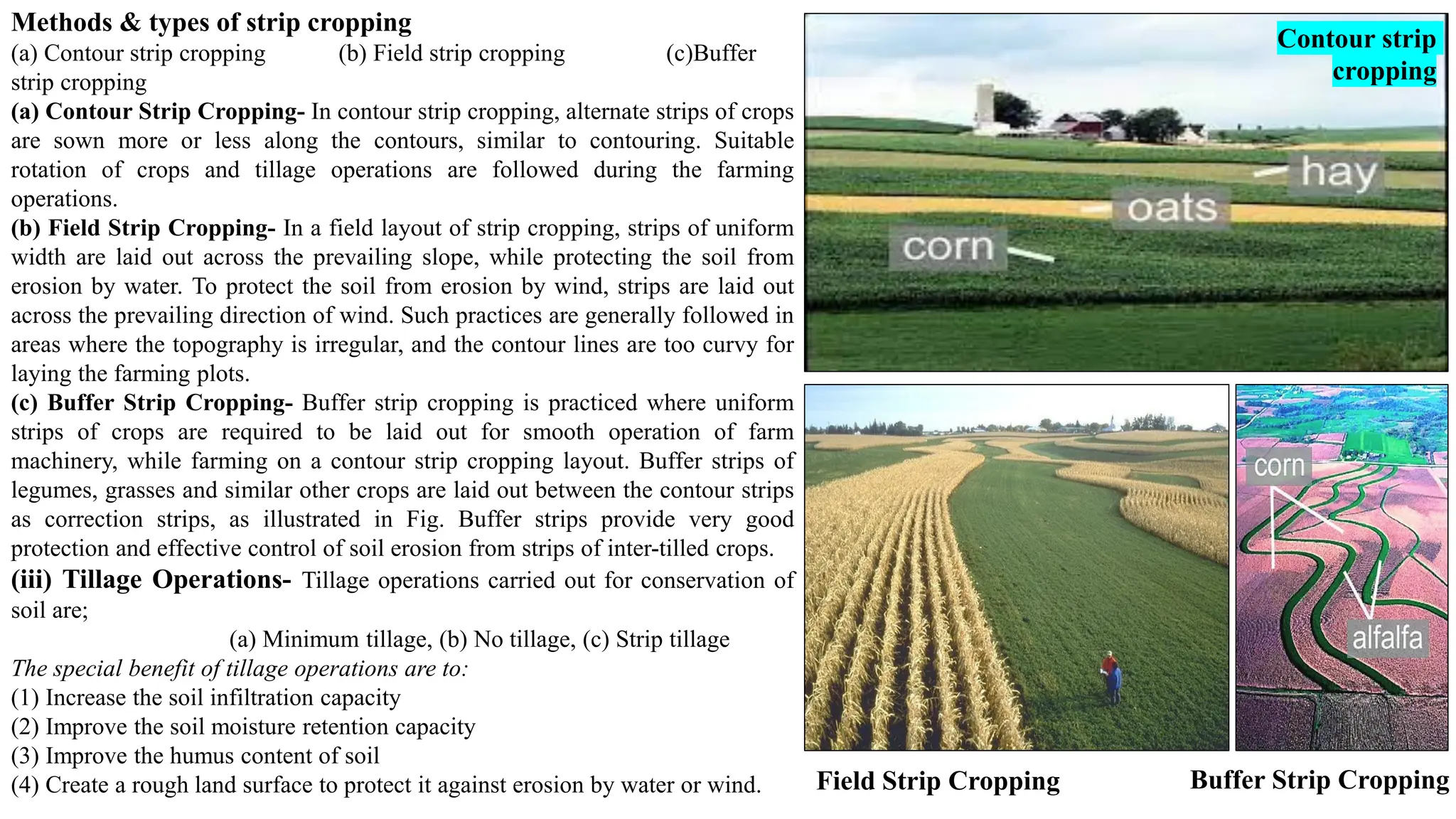
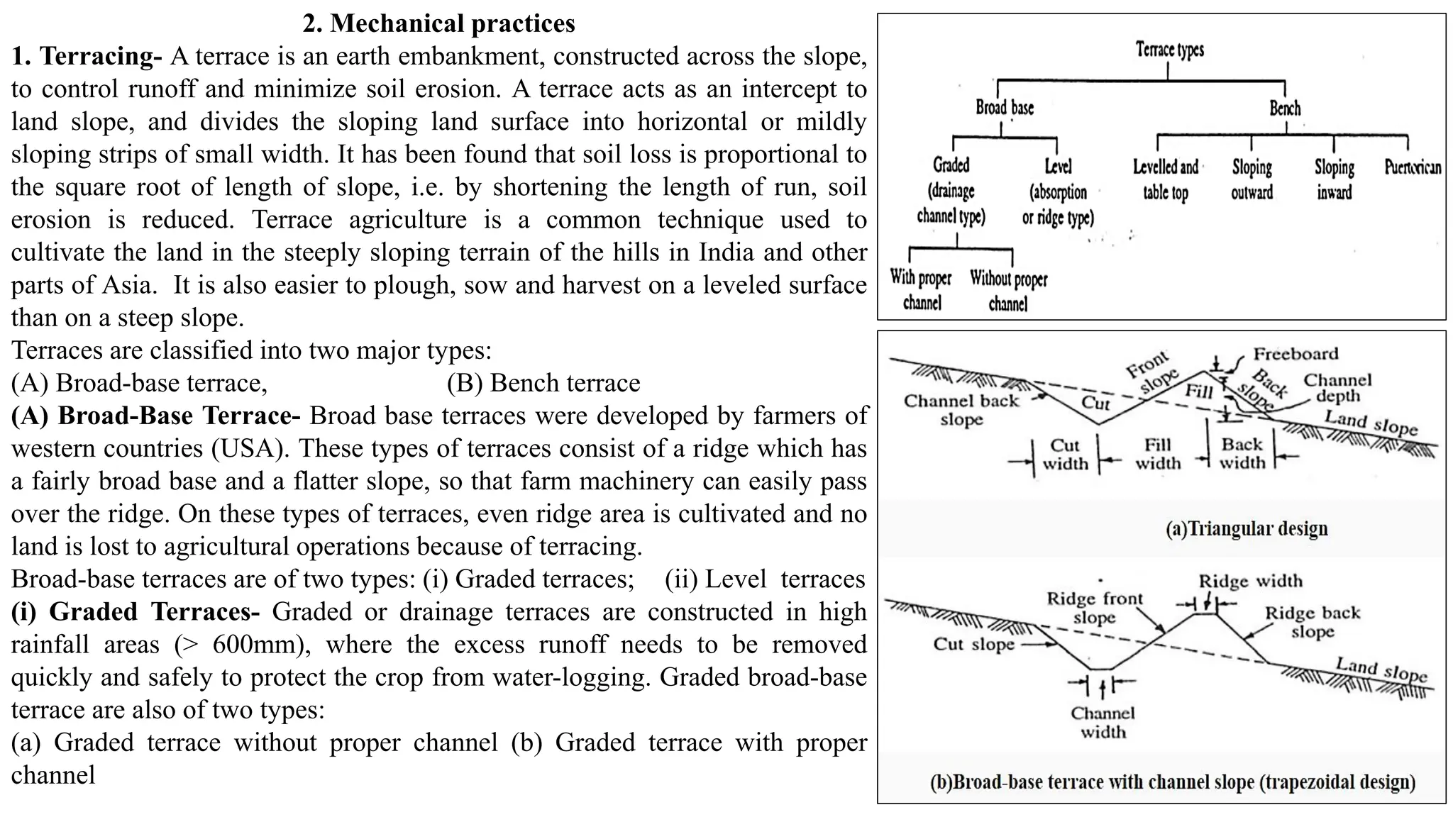
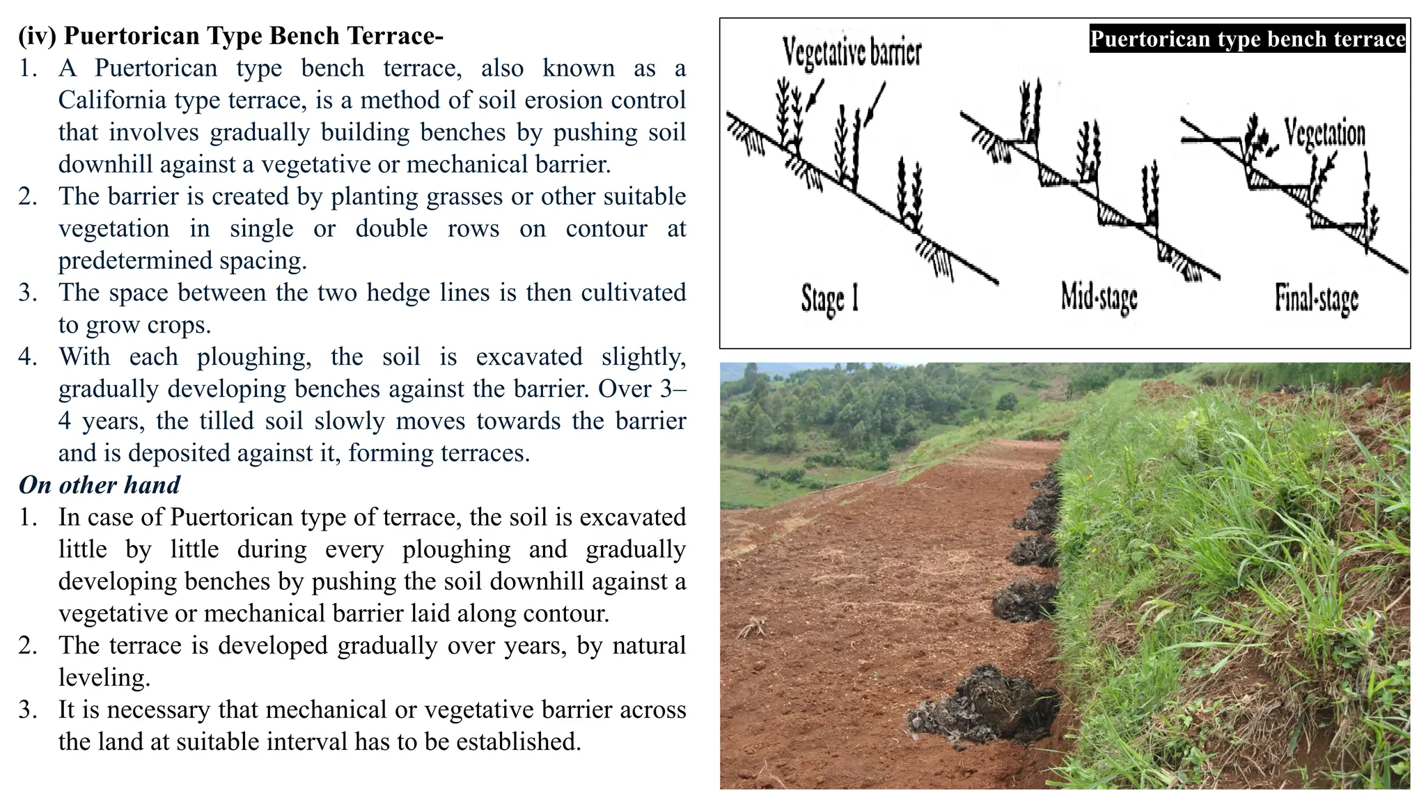
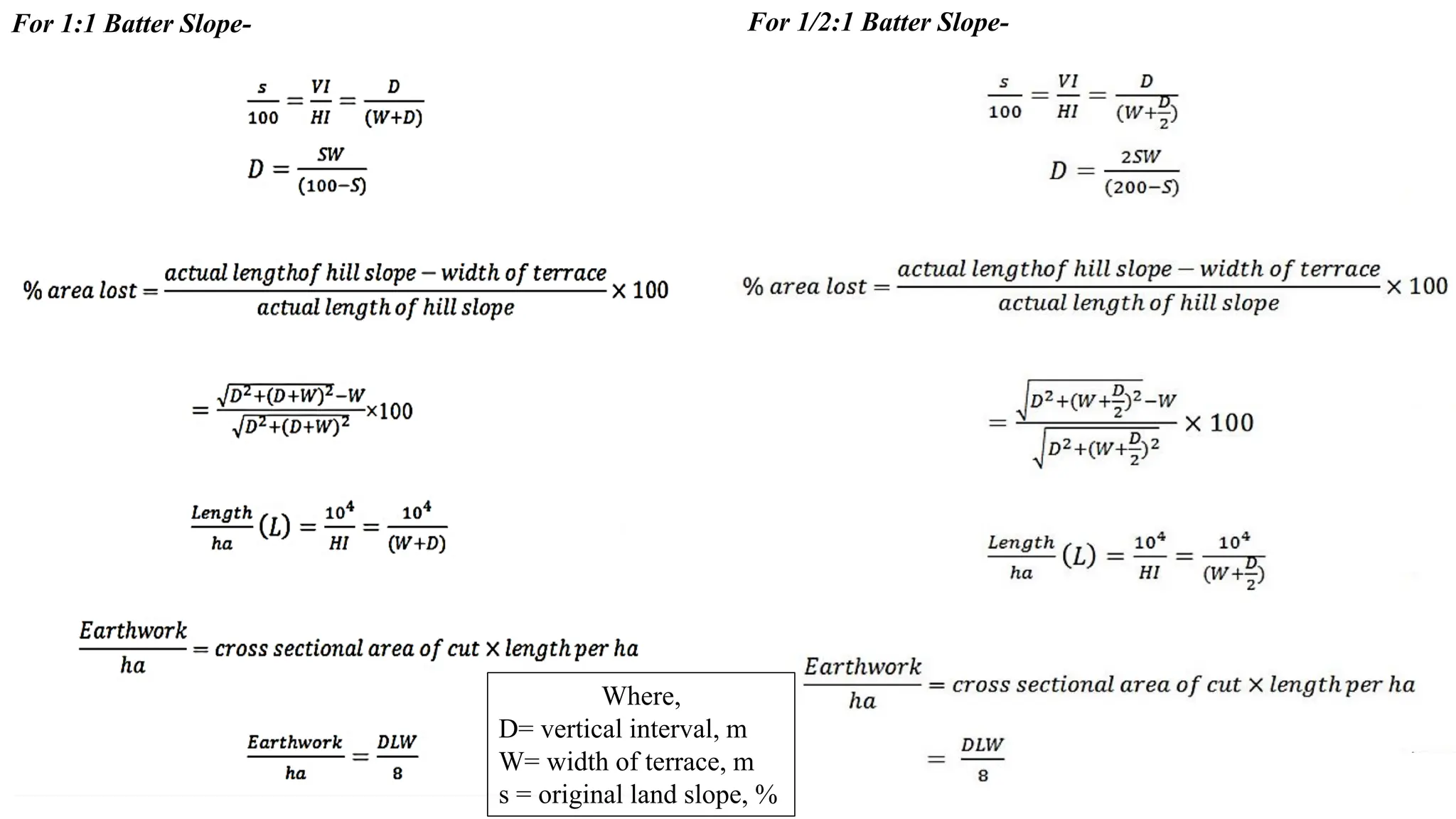
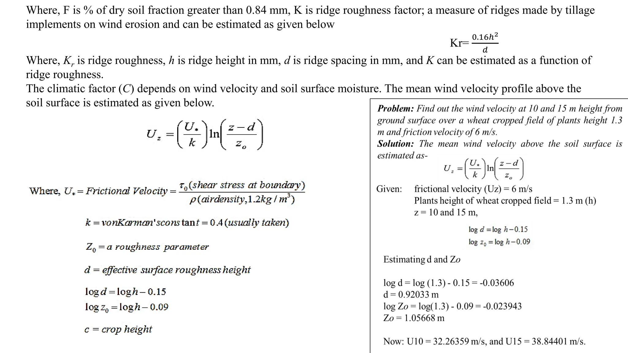
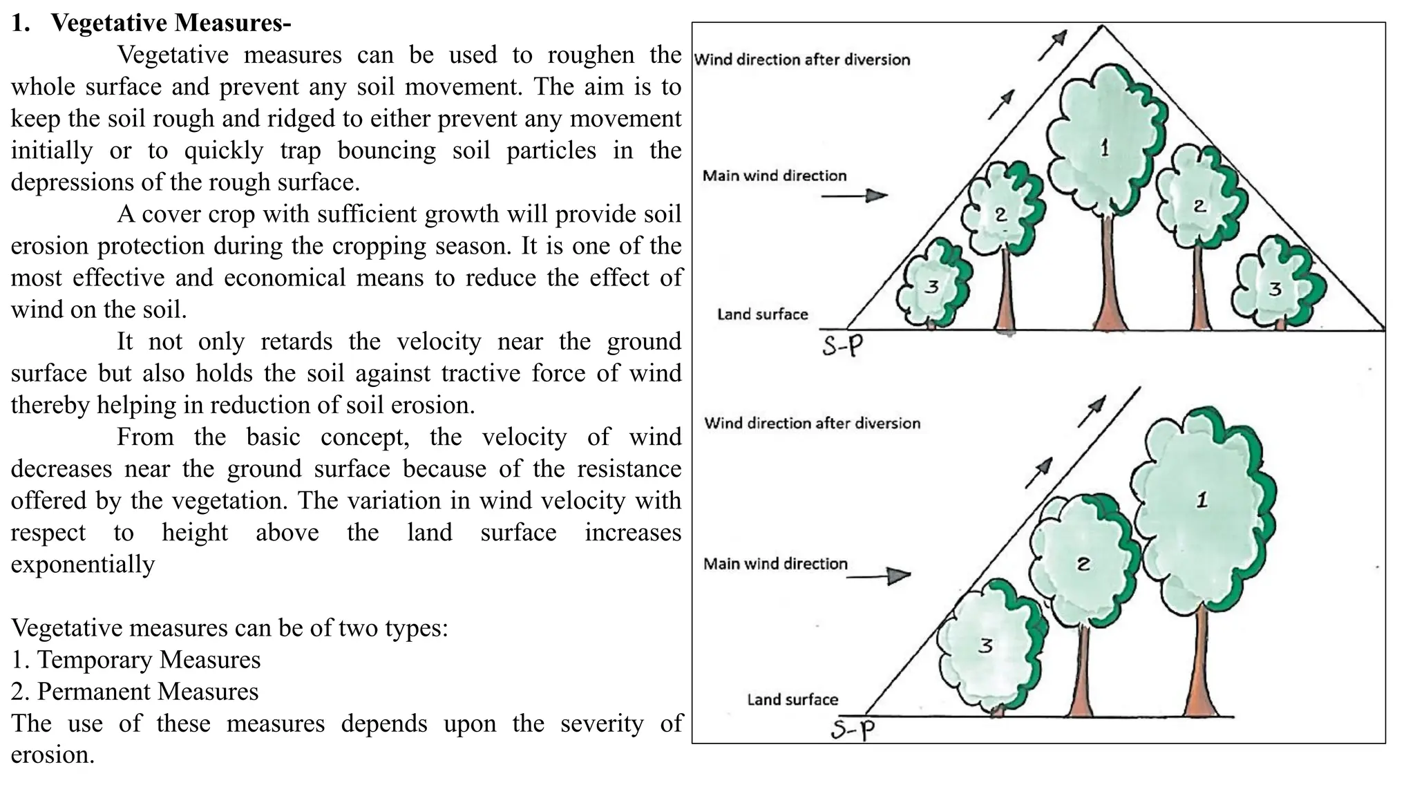
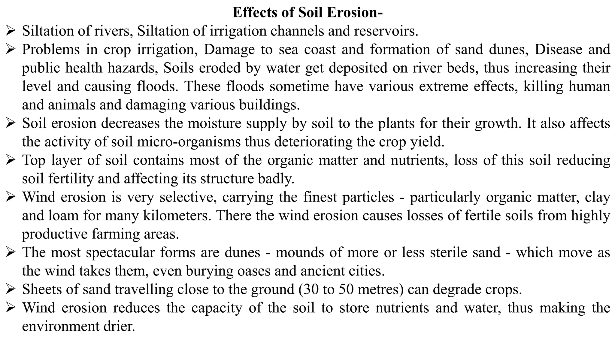
1. BASICS OF SOILAND WATER
CONSERVATION ENGINEERING
College of Agriculture and Research Station, Raigarh
INDIRA GANDHI KRISHI VISHWAVIDYALAYA, RAIPUR
CHHATTISGARH, 492012
For B.Sc. Ag.
Dr. Yogesh Kumar Kosariya
Teaching Professional (Agricultural Engineering Courses)
2. Outlines
1. General status of soil conservation in India and Introduction to soil and water conservation
2. Definition, causes and agents of soil erosion
3. Water erosion: forms and types of water erosion
4. Gully classification and control measures
5. Soil loss estimation by Universal soil loss equation
6. Soil loss measurement techniques
7. Principle of erosion control: introduction to contouring, strip cropping, contour bund
8. Graded bund and bench terracing
9. Grassed waterways and their design
10. Water harvesting and its techniques
11. Wind erosion: mechanics of wind erosion, types of soil movement
12. Principle of wind erosion control and its control measures, problem on wind erosion
3. 1. Status of soil conservation in India
Soil degradation in India is estimated to be occurring on 147 million
hectares of land which includes;
➢ 94 Mha from water erosion
➢ 16 Mha from acidification,
➢ 14 Mha from flooding,
➢ 9 Mha from wind erosion,
➢ 6 Mha from salinity, and
➢ 7 Mha from a combination of factors.
Soil degradation are both natural and human-induced
Natural causes- earthquakes, tsunamis, droughts, avalanches,
landslides, volcanic eruptions, floods, tornadoes, and wildfires.
Human-induced soil degradation results from - land clearing and
deforestation, inappropriate agricultural practices, improper
management of industrial effluents and wastes, over-grazing,
careless management of forests, surface mining, urban sprawl, and
commercial/industrial development
Inappropriate agricultural practices -excessive tillage, use of
heavy machinery, excessive and unbalanced use of inorganic
fertilizers, poor irrigation-water management techniques, overuse
pesticide, inadequate crop residue or organic carbon inputs, and poor
crop cycle planning
4. Some effects of Soil Erosion in India
• Soil erosion results in huge loss of nutrients in suspension or
solution, which are washed away from one place to another,
thus causing depletion or enrichment of nutrients.
• Besides the loss of nutrients from the topsoil
• There is also degradation through the creation of gullies and
ravines.
• Water causes sheet-wash, surface gullies, tunnels and scours
banks in rivers.
• In hot and dry climate of India, wind blowing is the main
cause of soil erosion.
Importance to Soil Conservation –
➢ Soil and water conservation is essential to protect the
productive lands of the world.
➢ In our country, where droughts, famines and floods cause
crop damage almost every year, soil conservation will not
only increase crop yields but also prevent floods and further
deterioration of land.
➢ Prior to the days of independence, while general problems of
soil erosion were known, answers to them backed by
scientific investigations were not known.
➢ Consequently, during the framing of the first year plan and
early in the second five year plan, a chain of 9 Soil
Conservation Research Demonstration and Training Centers
5. Central Soil and Water Conservation Research and Training Institute(CSWCRTI) -The CSWCRTI with its headquarters at Dehra
Dun and 8 research centers across the country, viz. Agra, Bellary, Chandigarh, Datia, Koraput, Kota, Udhgamandalam and Vasad
has the national mandate to conduct research and imparting training on soil and water conservation, Natural Resource
Management (NRM) and IWM.
-The Institute has developed many successful watershed models like Sukhomajri, Relmajra, Fakot, Sainji, and Kalimati
in different locations of the country.
-Central Soil and Water Conservation Research and Training Institute have been training various clients including local,
regional, national and international farmers, technocrats, scientists, planners and students through regular (5½ months biannually)
and many demand-based short term (1-30 days) training programs since its inception during the 1950s.
-A total of over 10,000 beneficiaries from various organizations directly beside an equal number through indirect ways
have been trained on soil-water conservation and watershed management by the Institute.
-In India, out of 328 million hectares of geographical area, 68 million hectares are critically degraded while 107 million
hectares are severely eroded. That's why soil and water should be given first priority from the conservation point of view and
appropriate methods should be used to ensure their sustainability and future availability
Central soil and water conservation research demonstration and training centers in India acc to (Tejwani 1980)
Location Region Date of start
Dehradun North western Himalayan 28-09-1954
Chandigarh Sub-montane tracts in the north western region 28-09-1954
Ootakamund Southern hill high rainfall region 10-10-1954
Bellary Semi-arid black soil region, nilgiris hill 20-10-1954
Kota Along the Chambal river in Rajasthan 19-10-1954
Vasad Along the rivers of Gujarat state 11-05-1955
Agra Along the Yamuna river and its industries 22-07-1955
Hyderabad Red soil, semi-arid region 10-01-1962
Chattra North eastern Himalayan region (Kosi river) 19-12-1956
6. History of Soil Erosion and Soil Conservation Programs in India- To meet the demand for food, fibre, fuel wood
and fodder owing to increasing population;
(1) The Pre-Independence Era- Soil conservation research in India was initiated during 1933-35 when the then Imperial (now Indian) Council of Agricultural
Research decided to establish its regional centers for R&D of dry farming at Sholapur (Maharashtra), Bijapur, Raichur, Bellary (Karnataka) and Rohtak (Haryana).
(2) Post-Independence Period- A conference was held in New Delhi in September, 1953. The conference considered that at the state level, existing organizations and
state development committees should be entrusted with the task of formulating soil conservation programmes.
(3) First Five Year Plan (1951-56)- With a view to develop a research base for soil conservation, a Soil Conservation Branch and a Desert Afforestation Research
Station at Jodhpur were established under the control of Forest Research Institute, Dehra Dun
(4) Second Five Year Plan (1956-61)- Desert Afforestation and Soil Conservation Centre at Jodhpur were developed into the Central Arid Zone Research Institute
(CAZRI) in 1959 with collaboration of UNESCO.
(5) Third Five Year Plan (1961-66)- The Government of India reorganized the Soil Conservation Division in the Ministry of Agriculture and redesignated the Senior
Director as Advisor and entrusted him with the responsibility of coordinating the soil and water conservation development
(6) Fourth Five Year Plan (1969-74)- Under this plan, All India Soil & Land Use Survey prepared a detailed analysis of different watersheds of the country. The
concept of Integrated Watershed Management was successfully introduced at field level in different parts of the country.
(7) Fifth Five Year Plan (1974-79)-In this plan, the Government of India introduced many centrally sponsored programmers, viz; Drought Prone Area Programme
(DPAP), Flood Prone Area Programme (FPAP), Rural Development Programme (RDP), and Desert Development Programme (DDP).
(8) Sixth Five Year Plan (1980-85)-In this plan period, more emphasis was given on the treatment of small watersheds varying in size up to 2000 hectare. An
intensive programme for integrated management of about 200 sub watersheds of 8 flood prone catchments of Ganga river basin was undertaken during this plan.
(9) Seventh Five Year Plan (1985-90)- National Watershed Development Programme for Rainfed Areas (NWDPRA) was launched in the 7th Plan in 99 selected
districts in the country
(10) Eighth Five Year Plan (1990-95)-Ministry of Agriculture, Department of Agriculture and Cooperation, New Delhi formulated the guidelines for the
implementation of NWDPRA and published it in the form of a document commonly known as WARASA (Watershed Areas Rainfed Agriculture System Approach)
(11) Ninth Five Year Plan (1997-02)-The centrally sponsored scheme for reclamation of alkali soils was launched during the Seventh Five Year Plan in the states of
Haryana, Punjab and Uttar Pradesh. It continued during the Eighth Five Year Plan and was extended to the states of Gujarat, Madhya Pradesh and Rajasthan
(12) Tenth Five Year Plan (2002-07)-The Tenth Five Year Plan (2002-2007) has put emphasis on natural resource management through rainwater harvesting,
groundwater recharging measures and controlling groundwater exploitation, watershed development, treatment of waterlogged areas
(13) Eleventh Five Year Plan (2007-12)-For the purpose of conserving soil and water, were funded through various schemes including National Watershed
Development Projects in Rainfed Areas (NWDPRA), River Valley Projects (RVP), and Integrated Wasteland Development Programme (IWDP). Emphasis has
been given to increase the water resources availability and their efficient use.
7. Broad objectives of these Centre’s
(i) To identify erosion problems and conservation of land and water resources under different land use systems,
(ii) To evolve mechanical and biological methods of erosion control under different land use systems,
(iii) To evolve methods of control of erosion and reclamation of ravines stabilization of landslides and hill torrents,
(iv) To evaluate hydrological behavior and evolve techniques of watershed management under different systems,
(v) To set up demonstration projects for popularizing soil and water conservation measures,
(vi) To impart specialized training in soil and water conservation to gazetted and non-gazetted officers of State Governments.
Important Soil and Water Conservation Programmes implemented by Govt.
➢ Soil conservation in catchments of river valley project (RVP).
➢ Integrated Watershed Management in the catchments of flood Prone Rivers (FPR).
➢ Centrally Aided Drought Prone Area Development Program (DPAP), (as per 1995 guidelines) implemented by Government and
NGO. Desert Development Programme ( DDP)
➢ National Watershed Development Program for Rain fed Area (NWDPRA) implemented by Dept. of Soil Conservation &
Watershed Management, Gov.M with financial support from Department of Agriculture, Gov.I
➢ Operational Research Projects on Integrated Watershed Management (ICAR)
➢ World Bank Project on Watershed Development in Rain fed Area.
➢ Council for Peoples Action & Rural Technology (CAPART) supported 38 Watershed Development Programs in Maharashtra.
➢ DPAP & IWDP projects (of 2001 guidelines) in Satara, Sangali& Nasik Districts of Maharashtra state.
➢ NABARD Holistic Watershed Development Programme
➢ Vasundhara Watershed Development Project
➢ Maharashtra government has launched a new programme named ‘JalyuktaShivarAbhiyan’ in a state on January 26, 2015. The
programme aim to make 5000 villages free of water scarcity every year and to conserve and protect the soil from further
degradation.
8. What is Soil Erosion?
• The uppermost weathered and disintegrated layer of the earth’s crust is referred to as soil.
• The soil layer is composed of mineral and organic matter and is capable of sustaining plant life.
• The soil depth is less in some places and more at other places and may vary from practically nil to several metres.
• The soil layer is continuously exposed to the actions of atmosphere.
• Wind and water in motion are two main agencies which act on the soil layer and dislodge the soil particles and
transport them.
• The loosening of the soil from its place and its transportation from one place to another is known as soil erosion.
• The word erosion has been derived from the Latin word ‘erodere’ which means eating away or to excavate. The
word erosion was first used in geology for describing the term hollow created by water.
• Erosion actually is a two phase process involving the detachment of individual soil particle from soil mass,
transporting it from one place to another (by the action of any one of the agents of erosion, viz; water, wind, ice or
gravity) and its deposition.
• Hence soil erosion is defined as a process of detachment, transportation and deposition of soil particles
(sediment). It is evident that sediment is the end product of soil erosion process. Sediment is, therefore, defined as
any fragmented material, which is transported or deposited by water, ice, air or any other natural agent.
Soil Detachment Transportation Deposition
❖ Detachment is the dislodging of the soil particle from the soil mass by erosive agents. In case of water erosion, major erosive
agents are impacting raindrops and runoff water flowing over the soil surface.
❖ Transportation is the entrainment and movement of detached soil particles (sediment) from their original location.
❖ Sediments move from the upland sources through the stream system and may eventually reach the ocean. Not all the sediment
reaches the ocean; some are deposited at the base of the slopes, in reservoirs and flood plains along the way.
9. The major land degradation problems due to sedimentation are briefly discussed as below
a) Erosion by wind and water: Out of 144.12 M-ha areas affected by water and wind erosion.
b) Gullies and Ravines: About 4 M-ha is affected by the problem of gullies and ravines in the country covering
about 12 states
c) Torrents and Riverine Lands: Problem of Riverine and torrents is spread over an area of 2.73 M-ha in the country.
d) Water logging: Water logging is caused either by surface flooding or due to rise of water table. An area of 8.53 M-
ha has been estimated to be affected by water logging
e) Shifting Cultivation: Shifting cultivation, also known as ‘jhuming’ is a traditional method of growing crops on hill
slopes by slash and burn method
f) Saline soil including coastal areas: About 5.5 M-ha area is affected by this problem in the country which includes
arid and semi-arid areas of Rajasthan and Gujarat, black soil region and coastal areas
g) Floods and Droughts: In India, among the major and medium rivers of both Himalayas and non-Himalayas
categories, 18 are flood prone which drain an area of 150 M-ha.
Soil Conservation Programmes- Various watershed development programmes are being implemented by mainly
three ministries, namely, Ministry of Agriculture, Ministry of Rural Development and Ministry of Environment
and Forests for development of degraded lands. These programmes are listed below,
1. National Watershed Development Project for Rainfed Area (NWDPRA), 2. River Valley Project & Flood Prone
River (RVP & FPR), 3. Watershed Development Project for Shifting Cultivation Area (WDPSCA), 4.
Reclamation & Development of Alkali and Acid Soil (RADAS), 5.Watershed Development Fund (WDF), 6.
Drought Prone Area Programme (DPAP), 7. Desert Development Programme (DDP), 8. Integrated Wasteland
Development Project (IWDP), 9. National Afforestation and Eco-Development Project (NAEP)
10. Need and Importance for Soil Conservation
1. To sustain the production from natural resources to meet the basic requirements of food, shelter and clothing of
growing population.
2. To preserve topsoil to reduce deterioration in soil fertility and the water holding capacity, thus sustaining
productivity.
3. To check the formation of rills and gullies due to soil erosion in the field, which adversely affect the productivity.
4. To increase the groundwater recharge, by sustaining the soil moisture retention capacity of the soil.
5. To maintain the land productivity and prevent shrinkage of arable area.
6. To reduce the dredging work due to sedimentation in creeks, rivers, lakes and reservoirs.
7. To protect water bodies from non-point source pollution.
8. To minimize the flooding risk that affects the sustainability and livelihoods of humans, animals and plants.
9. To control the deterioration of ecosystem due to soil loss, which leads to interruption of nutrient cycle, loss of soil
fertility, extinction of flora and fauna and soil erosion etc. ultimately resulting in biological impoverishment and
human sufferings.
10. To facilitate environmental system that affects the plant growth and rejuvenation of forests.
11. 2. Definition, causes and agents of soil erosion
Soil erosion is the process by which soil is removed from the Earth's surface by exogenetic processes such as wind or
water flow, and then transported and deposited in other locations. soil erosion implies the physical removal of topsoil
by various agents, including rain, water flowing over and through the soil profile, wind, glaciers or gravitational pull.
Land and water are the most precious natural resources that support and sustain the anthropogenic activities. In India
almost 130 million hectares of land, i.e., 45 % of total geographical surface area, is affected by serious soil erosion
through gorge and gully, shifting cultivation, cultivated wastelands, sandy areas, deserts and water logging. In Indian
condition, the control of soil erosion is a challenging task in the sense that the onset of monsoon often coincides with
the kharif sowing and transplanting.
Principles of Soil Erosion
Causes of Soil Erosion No single unique cause can be held responsible for soil erosion or assumed as the main cause
for this problem. There are many underlying factors responsible for this process, some induced by nature and others
by human being. The main causes of soil erosion can be enumerated as:
(1) Destruction of Natural Protective Cover by
(i) Indiscriminate cutting of trees, (ii) Overgrazing of the vegetative cover and (iii) Forest fires.
(2) Improper Use of the Land
(i) Keeping the land barren subjecting it to the action of rain and wind, (ii) Growing of crops that accelerate
soil erosion, (iii) Removal of organic matter and plant nutrients by injudicious cropping patterns, (iv) Cultivation
along the land slope, and (v) Faulty methods of irrigation.
Factors affecting soil erosion- 1. Climatic Factor, 2. Temperature, 3. Topographical Factors,
4. Soil, 5. Vegetation, 6. Biological Factors of Soil Erosion,
13. Types of Soil Erosion
Broadly, soil erosion can be divided into three categories depending on the eroding agents namely water erosion, wind erosion and
chemical or geological erosion. Soil erosion due to the agents like water and wind is mostly prevalent and tangible. Water erosion
is further subdivided, These include splash, sheet, rill, gully, land slide or slip erosion and stream bank erosion.
1. Geologic Erosion
Geologic erosion sometimes referred to as natural or normal erosion; represent erosion under the cover of vegetation. It includes
soil as well as soil eroding processes that maintain the soil in favorable balance, suitable for the growth of most plants. The rate of
erosion is so slow that the loss of soil is compensated by the formation of new soil under natural weathering processes. The various
topographical features such as existing of streams, valleys, etc. are the results of geologic erosion. The erosion caused through
chemical and geological agents is a slow process and continues to years and often it is non tangible.
2. Accelerated Erosion
When land is put under cultivation, the natural balance existing between the soil, its vegetation cover and climate is disturbed.
Under such condition, the removal of surface soil due to natural agencies takes places at faster rate than it can be built by the soil
formation process. Erosion occurring under these condition is referred to as accelerated erosion. Its rates are higher than geological
erosion. Accelerated erosion depletes soil fertility in agricultural land.
3. Glacial Erosion
Glacial erosion, also referred to as ice erosion, is common in cold regions at high altitudes. When soil comes in contact with large
moving glaciers, it sticks to the base of these glaciers. This is eventually transported with the glaciers, and as they start melting it is
deposited in the course of the moving chunks of ice.
4. Gravitational Erosion
Although gravitational erosion is not as common a phenomenon as water erosion, it can cause huge damage to natural, as well as
man-made structures. It is basically the mass movement of soil due to gravitational force. The best examples of this are 3
landslides and slumps. While landslides and slumps happen within seconds, phenomena such as soil creep take a longer period for
occurrence.
14. 5. Wind Erosion (Agent Based)
o Wind erosion is the detachment, transportation and redeposition of soil particles by wind.
o A sparse or absent vegetative cover, a loose, dry and smooth soil surface, large fields and strong winds all increase the risk of
wind erosion.
o Air movement must attain a certain velocity (with enough speed to generate visible movement of particles at the soil level)
before it can generate deflation and transport of particles.
o Winds with velocities of less than 12-19 km/h seldom impart sufficient energy at the soil surface to dislodge and put into
motion sand-sized particles.
o Drifting of highly erosive soil usually starts when the wind attains a forward velocity of 25-30 km/h.
o Wind erosion tends to occur mostly in low rainfall areas when soil moisture content is at wilting point or below, but all drought-
stricken soils are at risk.
o Often the only evidence of wind erosion is an atmospheric haze of dust comprising fine mineral and organic soil particles that
contain most of the soil nutrients.
o Actions to minimize wind erosion include improving soil structure so wind cannot lift the heavier soil aggregates; retaining
vegetative cover to reduce wind speed at the ground surface; and planting windbreaks to reduce wind speed.
Process of Wind Erosion-
1. Saltation: Saltation occurs when the wind lifts larger particles off the ground for short distances, leading to sand drifts. Fine
and medium sand-sized particles (0.10-0.15 mm diameter) are lifted a short distance into the air, dislodging more soil as they
fall back to the ground.
2. Suspension: Suspension occurs when the wind lifts finer particles into the air leading to dust storms. Very fine soil particles
(0.5-1.0 mm diameter) are lifted from the surface by the impact of saltation and carried high into the air, remaining suspended
in air for long distances.
3. Surface Creep: The movement of large soil particles (less than 0.1 mm) along the surface of the soil after being loosened by
the impact of saltating particles.
15. Extent of Wind Erosion- Several factors, other than the
wind velocity itself, contribute to wind erosion. These fall
into two main groups of closely interrelated elements: those
inherent in the properties of the soil per se and those
associated with soil cover.
A rough soil structure, especially at the surface, effectively
reduces the movement of soil particles. Arid regions,
however, are dominated by smooth, pulverized and structure
less top soils.
Soil texture also influences soil erodibility; soils of fine
texture are, for example, particularly susceptible to wind
erosion. Measurements of dust in the air up to three metres
above the soil surface at Jodhpur, India, showed that on a
stormy day the amount of dust blowing varied between 50
and 420 kg/ha. In the Jaisalmer region of India, where wind
speeds generally are higher, average soil loss of 511 kg/ha
was recorded.
According to Global Assessment of Human-induced Soil
Degradation (GLASOD), 21.6 Mha area of Indian soil is
affected by wind erosion, which account for 6% of total
geographical area. However, area varied from 12.9 to 38.7
Mha from various sources.
GLASOD assessment: areas affected by wind erosion (Unit: 1000 ha) -
South Asian Countries
16. 6. Water erosion: forms and types of water erosion (Agent based)
The soil erosion caused by water as an agent is called water erosion. In water erosion, the water acts as an agent to
dislodge and transport the eroded soil particle from one location to another.
Extent of Water Erosion- The extent of water erosion in Indian subcontinent. In India, 32.8 Mha area in India is
affected by water erosion which accounts for 18% of the land. However, the water erosion extent estimated by
different sources varies from 87 to 111 Mha in India. National Bureau of Soil Survey & Land Use Planning
(NBSS&LUP 2005) estimates the erosion extent are higher in case of water erosion and lower in case of wind erosion
when compared to GLASOD.
Types of Water Erosion
1. Splash Erosion This type of soil erosion is because of
the action of raindrop. The kinetic energy of falling
raindrop dislodges the soil particle and the resultant runoff
transports soil particles. Splash erosion is the first stage of
soil erosion by water. It occurs when raindrops hit bare
soil. The explosive impact breaks up soil aggregates so
that individual soil particles are ‘splashed’ onto the soil
surface. The splashed particles can rise as high 0.60 meter
above the ground and move up to 1.5 meter from the point
of impact. The particles block the spaces between soil
aggregates, so that the soil forms a crust that reduces
infiltration and increases runoff. Splash erosion
17. 2. Sheet Erosion-the removal of soil in thin layers by raindrop impact and
shallow surface flow. This action called skimming and is prevalent in the
agricultural land. It results in loss of the finest soil particles that contain most of
the available nutrients and organic matter in the soil. Soil loss is so gradual that
the erosion usually goes unnoticed, but the cumulative impact accounts for
large soil losses. This type of soil erosion is mainly responsible for loss of soil
productivities. Soils most vulnerable to sheet erosion are overgrazed and
cultivated soils where there is little vegetation to protect and hold the soil. Early
signs of sheet erosion include bare areas, water puddling as soon as rain falls,
visible grass roots, exposed tree roots, and exposed subsoil or stony soils. Soil
deposits on the high side of obstructions such as fences may indicate active
sheet erosion. Vegetation cover is vital to prevent sheet erosion because it
protects the soil, impedes water flow and encourages water to infiltrate into the
soil.
3. Rill Erosion- Rills formation is the intermittent process of transforming to gully
erosion. The advance form of the rill is initial stage of gully formation. The rills are
shallow drainage lines less than 30cm deep and 50 cm wide. They develop when
surface water concentrates in depressions or low points through paddocks and
erodes the soil. Rill erosion is common in bare agricultural land, particularly
overgrazed land, and in freshly tilled soil where the soil structure has been
loosened. The rills can usually be removed with farm machinery. Rill erosion is
mostly occurs in alluvial soil and is quite frequent in Chambal river valley in India
Sheet erosion
Rill erosion
18. 4. Gully Erosion- The advance stage of rills is transformed into initial stage of gully. Gully formation are initiated
when the depth and width of the rill is more than 50 cm. Gullies are deeper channels that cannot be removed by
normal cultivation. Hillsides are more prone to gullying when they cleared of vegetation, through deforestation, over-
grazing or other means. The eroded soil is easily carried by the flowing water after being dislodged from the ground,
normally when rainfall falls during short, intense storms. Depending upon the depth and width, the gullies further
divided into 4 classes namely G1, G2, G3 and G4. Gullies reduce the productivity of farmland where they incise into
the land, and produce sediment that may clog downstream water bodies. Because of this, much effort are required to
invested into the study of gullies within the scope of geomorphology, in the prevention of gully erosion, and in
restoration of gullied landscapes.
The total soil loss from gully formation and subsequent downstream
river sedimentation can be sizable. Classification of gully;
Gully erosion
Types of Gully Erosion
19. 5. Tunnel Erosion-it occurs when surface water moves into and through dispersive
sub soils. Dispersive soils are poorly structured so they erode easily when wet. The
tunnel starts when surface water moves into the soil along cracks or channels or
through rabbit burrows and old tree root cavities. Dispersive clays are the first to be
removed by the water flow. As the space enlarges, more water can pour in and
further erode the soil. As the tunnel expands, parts of the tunnel roof collapse
leading to potholes and gullies. Indications of tunnel erosion include water seepage
at the foot of a slope and fine sediment fans downhill of a tunnel outlet. This type
of erosion is more frequent in foothills where elevation is between 500-750 meter.
6. Stream Bank- it occurs where streams begin cutting deeper and
wider channels as a consequence of increased peak flows or the
removal of local protective vegetation. Stream bank erosion is common
along rivers, streams and drains where banks have been eroded,
sloughed or undercut. This is quite prevalent in alluvial river and
streams. Generally, stream bank erosion becomes a problem where
development has limited the meandering nature of streams, where
streams have been channelized, or where stream bank structures (like
bridges, culverts, etc.) are located in places where they can actually
cause damage to downstream areas. Stabilizing these areas can help
protect watercourses from continued sedimentation, damage to
adjacent land uses, control unwanted meander, and improvement of
habitat for fish and wildlife.
Tunnel erosion
Stream bank erosion
20. 7.Coastal erosion- The waves, geology and geomorphology are the three
major factors that affect the coastal erosion. Waves are the cause of coastal
erosion. Wave energy is the result the speed of the wind blowing over the
surface of the sea, the length of fetch and the wind blowing time. The
geology of the coastline also affects the rate of erosion. If the coast is
made of a more resistant type of rock (say, granite), the erosion rate will be
lower than if the coast is made of a less resistant type of rock (say, boulder
clay).The geomorphology (or shape) of the coastline further affects the
rate of erosion. Headlands cause wave refraction, making waves converge
and combining their energy. Wider, shallower bays, meanwhile, allow
waves to diverge, losing energy due to friction with the sea bed. A wider
beach cause more wave energy to be lost due to friction before the waves
can break. A narrower beach will mean that the breaking point of the
waves is closer to the coastline, and less energy will have been lost due to
friction before they break. The coastal erosion is a major concern for India
as about 40% of the Indian coasts are subjected to severe erosion.
8. Landslide Erosion: When gravity combines with heavy
rain or earthquakes, whole slopes can slump, slip or slide.
Slips occur when the soil (topsoil and subsoil) on 8 slopes
becomes saturated. Unless held by plant roots to the
underlying surface, it slides downhill, exposing the underlying
material. Landslide Erosion
Coastal Erosion
21. Effects of Soil Erosion-
➢ Siltation of rivers, Siltation of irrigation channels and reservoirs.
➢ Problems in crop irrigation, Damage to sea coast and formation of sand dunes, Disease and
public health hazards, Soils eroded by water get deposited on river beds, thus increasing their
level and causing floods. These floods sometime have various extreme effects, killing human
and animals and damaging various buildings.
➢ Soil erosion decreases the moisture supply by soil to the plants for their growth. It also affects
the activity of soil micro-organisms thus deteriorating the crop yield.
➢ Top layer of soil contains most of the organic matter and nutrients, loss of this soil reducing
soil fertility and affecting its structure badly.
➢ Wind erosion is very selective, carrying the finest particles - particularly organic matter, clay
and loam for many kilometers. There the wind erosion causes losses of fertile soils from highly
productive farming areas.
➢ The most spectacular forms are dunes - mounds of more or less sterile sand - which move as
the wind takes them, even burying oases and ancient cities.
➢ Sheets of sand travelling close to the ground (30 to 50 metres) can degrade crops.
➢ Wind erosion reduces the capacity of the soil to store nutrients and water, thus making the
environment drier.
22. Process of gully development
After initiation, gully development is accelerated by,
✓ Erosion of the bed & sides (scouring of soil by flowing water plus debris & abrasive materials carried by it).
✓ Sliding and mass movement of the sides (due to seepage, alternate freezing and thawing and under cutting of
flow).
✓ Water-fall erosion at the gully head (resulting cutting of gully bank)
Stages of gully development
Stage;1 (Formation Stage)- Stage;2 (Development Stage)-Stage;3 (Healing Stage)-Stage;4 (Stabilization Stage)
Process of gully formation depends on;
❑ Resistance offered by top soil & underlying hard layer
❑ Rainfall characteristics that favors to increase volume of runoff over the land surface.
❑ Vegetation cover on the soil surface.
❑ Topography of the area including land slope.
❑ Creating land surface without vegetation.
❑ Faulty tillage practices.
❑ Overgrazing
❑ Absence of vegetative cover
❑ Not smoothening of rills, channels or depressions present on the ground surface.
❑ Improper construction of water channels, roads, rail lines, cattle trails etc.
3. Gully classification and control measures
23. Formation stage Stage-1 (Formation
Stage)/ Initiation Stage
• Initiation of gully erosion
• Channel erosion
• Deepening of gully bed
• Depends on top soil & other factors
• This stage proceeds slowly if top soil is resistant
Development stage Stage-2 (Development
Stage)
• Major formation of the gully and erosion takes
place
• Upstream movement of the gully head
• Enlargement of gully in width and depth
• Gully banks are eroded to maximum and width
becomes maximum
• Gully cuts to C-horizon and parent material is
removed rapidly
Healing stage Stage-3 (Healing Stage)
▪ Local vegetation starts growing in
the gully and get stabilized
▪ No significant erosion in any form
from gully section
▪ Healing process starts
Stabilization stage Stage-4
(Stabilization Stage)
• Last stage of gully development
• Gully gets fully stabilized Gully
• Gully reaches a stable gradient
• Gully walls attain stable slope
• Sufficient vegetation cover develops
over the gully surface to anchor the soil
and permit development of new top soil
• No further development of gully unless
healing process is disturbed
24. Classification of gully
Based on
• Shape of the gully
• State of the gully
• Dimension of the gully
Based on shape of the gully
• U-shaped
• V-shaped
U-shaped
Found in alluvial plains where surface and sub-surface soil are easily erodible
Runoff flow undermines and gully banks collapse
Formation of vertical side walls in U shape
V-shaped
Where sub-soil are tough to resist the rapid cutting of soil by runoff flow
Resistance to erosion increases with depth
Common in hilly regions accompanied with steep slope
25. Based on state of the gully
Active gullies: Whose dimensions are enlarged with time. Size enlargement is based on soil
characteristics, land use and volume of runoff passing through the gully. Found in plain areas.
Inactive gullies: Whose dimensions are constant with time. Found in rocky areas.
Based on dimension
26. Small Gully Medium Gully Large Gully
1. Can easily be crossed by farm
implements,
2. Removed by ploughing and
smoothing operations,
3. By stabilizing the vegetation
1. Cannot be easily crossed by farm
implements,
2. Can be controlled by terracing and
ploughing operations,
3. Sides are stabilized by creating
vegetation on them
1. Cannot be reclaimed,
2. Tree planting is done as an effective
method
Small
Medium
Large
27. 4. Soil loss estimation by universal soil loss equation
❑ The universal soil loss equation (USLE) developed by Wischmeier & Meyer; & the same was published in the year 1973 by
Wischmeier & Meyer.
❑ This equation was designated as Universal Soil Loss Equation, and in brief it is now as USLE. Since, simple & powerful, tool
for predicting the average annual soil loss in specific situations.
❑ The associated factors of equation can be predicted by easily available meteorological & soil data.
❑ The term ‘Universal’ refers consideration of all possible factors affecting the soil erosion/soil loss; and also its general
applicability.
❑ The shortcomings of the USLE model have been accounted for within the Revised Universal Soil Loss Equation (RUSLE).
❑ Modeling of soil erosion is depends upon the factors which effecting the soil erosion. Widely used erosion models are:
1. Empirical Models: Universal Soil Loss Equation (USLE)
Revised Universal Soil Los Equation (RUSLE)
2. Semi Empirical Models:
Modified Universal Soil Loss Equation (MUSLE)
Morgan, Morgan and Finney (MMF) Model
3. Physical Process-based Model:
Water Erosion Prediction Project (WEPP) Model
The USLE is given as under:
A = R. K. L. S. C. P.
Where, A = estimate gross soil erosion, t/ha/year
R = rainfall erosivity factor, joules/(ha/year), (t-m/ha) (mm/h) per year
K = Soil erodibility factor (t/ha)/erosivity factor (R), t/joules, t/ha-year
L = Slope length factor, S = Slope gradient factor, C = Crop cover or crop management factor
P = Supporting conservation practice factor
28. Rainfall Erosivity Factor (R): It refers to the rainfall erosivity index, which expresses the ability of rainfall to erode the soil
particles from an unprotected field. It is a numeral value. From long term field studies, it has been observed that the extent of soil
loss from a barren field is directly proportional to the product of two rainfall characteristics: 1) kinetic energy of the storm; and 2)
its 30- minute maximum intensity. The following equation is used for calculation of R-factor,
𝑅 = [
1
100
210.3 + 89𝑙𝑜𝑔𝐼𝑖 ℎ𝑖]𝐼𝑚𝑎𝑥30
Where, Ii = Intensity of rain in a given period (cm/h)
Hi =Amount of precipitation in that period (cm)
𝐼𝑚𝑎𝑥30 = Maximum intensity during a 30 minutes period (cm/h)
Soil Erodibility Factor (K): This factor is related to the various soil properties, by virtue of which a particular soil becomes
susceptible to get erode, either by water or wind. In general, the soil properties such as the soil permeability, infiltration rate, soil
texture, size & stability of soil structure, organic content and soil depth, affect the soil loss in large extent. It can be calculated by;
K = 2.8 * 10-7 M1.14 (12-a) + 4.3 * 10-3 (b-2) + 3.3*10-3 (c-3)
M = Particle size parameter (% silt + % very fine sand) (100-% clay)
a = % organic matter
b = Soil structure code (very fine granular,1; medium or coarse granular,3; blocky, platy or massive, 4),
C = Profile permeability class (rapid, 1; moderate rapid, 2; moderate, 3; slow to moderate 4; slow, 5; very slow, 6).
Slope Length and Steepness Factor (LS): The LS factor represents the erosive potential of a particular soil with specified slope
length and slope steepness. This factor basically affects the transportation of the detached particles due to surface flow of
rainwater, either that is the overland flow or surface runoff. The capability of runoff/overland flow to detach and transport the soil
materials gets increased rapidly with increase in flow velocity. On steep ground surface the runoff gets increase because of
increase in runoff rate. The factors- L and –S are described as under:
𝐿 =
[𝐿𝑝]𝑚
22.13
29. Where,
Lp = The actual unbroken length of the slope (meters) measured up to the point where the overland flow terminates, and
m is an exponent which is equal to 0.5 for slopes ≥ 5%, 0.4 for 4%, 0.3 for 3%, and 0.2 for 1%. Dvorak and Novak
(1994) have recommended the values for m as 0.5 for 10% and 0.6 for 10%.
Slope Length Factor (L)- The slope length is the horizontal distance from the point of origin of overland flow to the point where
either the slope gradient gets decrease enough to start deposition or overland flow gets concentrate in a defined channel.
Slope Steepness Factor (S)- Steepness of land slope influences the soil erosion in several ways. In general, as the steepness of
slope increases the soil erosion also increases, because the velocity of runoff gets increase with increase in field slope, which
allows more soil to detach and transport them along with surface flow. Wischmeier and Smith (1965) used the following formula
for determined of the factor S:
S=
0.43+0.306+0.043𝑠2
6.613
Where, S= the slope of the field plot (%)
Crop Management Practices Factor (C)- The crop management practices factor (C) may be defined as the ratio of soil loss from
a land under specific crop to the soil loss from a continuous fallow land, provided that the soil type, slope & rainfall conditions are
identical. The crop & cropping practices affect the soil erosion in several ways by the various features such as the kind of crop,
quality of cover, root growth, water use by growing plants etc. The C-factor indicates how the conservation, plan will affect the
average annual soil loss how and that soil-loss potential will be distributed in time during construction activities, crop relations or
other management schemes
Soil Conservation Practices Factor (P)- It may be defined as the ratio of soil loss under a given conservation practice to the soil
loss from up and down the slope. The conservation practice consists of mainly the contouring, terracing and strip cropping in
which contouring appears to be most effective practice on medium slopes ranging from 2 to 7 per cent. The P-factor reflects the
impact of support practices on the average annual erosion rate. It is the ratio of soil loss with contouring and / or strip cropping to
that with straight row forming up-and-down slope
30. Solve the following;
Example 1: Calculate the annual soil loss from a given field subject to soil erosion problem, for the following information:
• Rainfall erosivity index = 1000 m. tonnes/ha • Soil erodibility index = 0.20 • Crop management factor = 0.50
• Conservation practices factor = 1.0 • Slope length factor = 0.10 Also explain, how the soil loss is affected by soil
conservation practices.
Example 2: A field is cultivated on the contour for growing maize crop. The other details regarding USLE factors are as follows:
K = 0.40 R = 175 t/acre LS = 0.70 P = 0.55 C = 0.50
Compute the value of soil loss likely to take place from the field. Also, make a comment on soil loss when same field is kept under
continuous pasture with 95 percent cover. Assume the value of factor- C for new crop is 0.003.
Problem; In a 23 ha catchment, soil erosion is to be evaluated. The following information for the catchment is available. Calculate
the soil loss.
R = 1000 (MJ-mm/ha) (mm/h) per year
K = 0.25 M/ha/R
LS = 0.1
Contour - farming in 13 ha (P = 0.6)
Strip cropping in 9 ha (P = 0.3)
Crops are maize and cowpea (assume weighted C= 0.5)
Solution:
31. 5. Soil loss measurement techniques
Object: Measurement of soil loss from the field by using multi slot divisor. Multi slot divisor is useful for measuring
runoff from small plots. It can measure quantity of runoff and can estimate soil loss from field. Its design and
application is very simple. Mostly used for experiment purpose. It has mainly three parts:
• Collection tank • Slot divisor (spout) • Cistern tank
1. Collection tank: The collection tank is used to collect the runoff water from the plot. The water is diverted from
the plot and discharged into the collection tank. The tank has four compartments of different dimensions. The
dimension of the collection tank varies according to the size of the plot and probable runoff to be collected. The
probable runoff is calculated considering the plot size and maximum daily rainfall of the area. The collection tank
is provided with roof cap to avoid rain water falling into the tank.
2. Slot Divisor: The slot divisor with number of slots is used for experimentation, in which one slot is connected to
the cistern tank. The divisor is always provided with the odd number of slots. The number of slot are decided as
per the volume of water is to collected from the experimental plot. Larger the quantity of runoff, more are the slots
and vice versa. It is also covered with cap on its top. The middle slot connected to the cistern tank, to collect
excess runoff.
3. Cistern tank: It is the tank connected to the slot divisor to collect the runoff water for final measurement. The
capacity of the cistern tank is decided as per the probable runoff and number of slots. Procedure:
1. Select the particular field from where soil loss is to be measured.
2. Generally, the dimensions of the field are selected as 15 x 4 m.
3. Mark the plot boundary by erecting GI sheets along the boundary of plot such that no runoff water will enter
into the experimental field.
32. 4. The runoff collection channel is constructed to divert the runoff water towards collection tank.
5. Pipe is used to convey the runoff water into the tank.
6. At the end of the plot pit is excavated to install the multi slot assembly to collect runoff water and runoff samples.
Calculation of runoff volume and soil loss:
Runoff volume: The runoff water collected in the Cistern tank is measured by using following formula
Where,
V=l*r*h
V = volume of runoff water, 𝑚3
; l= length
r = radius of cistern tank, m
h = height of tank, m
This is the volume of runoff water collected through one slot. Convert it into total volume of water collected
from the plot considering the number of slots of the divisor. Then, calculate total volume of runoff water collected
from one hector of land.
Soil loss;
1. The runoff samples are collected from the collection tank in the bottles with continuous stirring of water.
2. Add alum to the water samples to allow the settlement of sediment in the sample bottles.
3. Keep it for 24 hrs for settlement.
4. Remove water from bottles.
5. Keep the soil/sediment for 24 hrs at 105ºC in oven dryer.
6. Then take dry weight of soil.
7. Calculate the soil loss in kg per hector.
33. 6. Principle of erosion control: introduction to contouring
What are contour lines?
Contour lines connect a series of points of equal elevation and are used to illustrate
relief on a map. They show the height of ground above mean sea level (MSL) either
in meters or feet, and can be drawn at any desired interval. For example, numerous
contour lines that are close to one another indicate hilly or mountainous terrain; when
further apart they indicate a gentler slope; and when far apart they indicate flat
terrain.
Purposes of Contouring Contour survey is carried out at the starting of any
engineering project such as a road, a railway, a canal, a dam, a building etc.
1. For preparing contour maps in order to select the most economical or suitable site.
2. To locate the alignment of a canal so that it should follow a ridge line.
3. To mark the alignment of roads and railways so that the quantity of earthwork
both in cutting and filling should be minimum.
4. For getting information about the ground whether it is flat, undulating or
mountainous.
5. To locate the physical features of the ground such as a pond depression, hill, steep
or small slopes.
Contour Interval & Horizontal Equivalent Contour Interval: The constant vertical
distance between two consecutive contours is called the contour interval. Horizontal
Equivalent: The horizontal distance between any two adjacent contours is called as
horizontal equivalent. The contour interval is constant between the consecutive
contours while the horizontal equivalent is variable and depends upon the slope of the
ground.
34. Characteristics of Contours
1. All points in a contour line have the same elevation.
2. Flat ground is indicated where the contours are widely separated and steep-slope where they run close together.
3. A uniform slope is indicated when the contour lines are uniformly spaced and
4. A plane surface when they are straight, parallel and equally spaced.
5. A series of closed contour lines on the map represent a hill, if the higher values are inside
6. A series of closed contour lines on the map indicate a depression if the higher values are outside.
7. Contour line cross ridge or valley line at right angles. If the higher values are inside the bend or loop in the contour, it indicates
a Ridge. If the higher values are outside the bend, it represents a Valley.
8. Contour lines cannot merge or cross one another on map except in the case of an overhanging cliff
9. Contour lines never run into one another except in the case of a vertical cliff. In this case, several contours coincide and the
horizontal equivalent becomes zero.
METHODS OF CONTOURING
(1) Direct Method: In this method, the contours to be located are directly traced out
in the field by locating and marking a number of points on each contour. These
points are then surveyed and plotted on plan and the contours drawn through
them.
(2) Indirect Method: In this method the points located and surveyed are not
necessarily on the contour lines but the spot levels are taken along the series of
lines laid out over the area .The spot levels of the several representative points
representing hills, depressions, ridge and valley lines and the changes in the slope
all over the area to be contoured are also observed. Their positions are then plotted
on the plan and the contours drawn by interpolation. This method of contouring is
also known as contouring by spot levels. (Square, cross & tacheometric method)
35.
36. 7. Soil Erosion & Control - takes place both due to natural
causes and anthropogenic factors. The adverse effects of
uncontrolled soil erosion are loss of valuable top soil lowering
crop productivity per unit of land, sedimentation in rivers and
irrigation canals drawing water from the rivers reducing their
carrying capacity, sedimentation of reservoirs reducing their active
life, structural damages to the buildings and formation of gullies
and ravines, to name a few important ones. Soil erosion control
measures are adopted to reduce or minimize the intensity of the
aforesaid adverse effects. Catchment Area Treatment (CAT) is
adopted to reduce soil loss from catchments due to runoff flow,
after ascertaining erosion severity on sub-watershed basis. CAT
comprises mechanical (engineering) and vegetative (afforestation)
measures. Mechanical and vegetative practices on agricultural
lands are employed on the milder slopes for conservation of soil,
by farming across the slope of the land. The basic principle
underlying this approach is to cause reduction in the effect of the
runoff velocity and, thereby reduce soil erosion. On steeper slopes,
mechanical measures (such as terracing) and other structures are
constructed to reduce the effect of the slope on runoff velocity.
The following types of vegetative and mechanical practices are
being used at present;
37. 1. Vegetative Practices
(i) Contouring (ii) Strip cropping (iii) Tillage operations (iv) Mulching
2. Mechanical Practices
(i) Terracing (ii) Bunding (iii) Grassed waterways and diversions
1. Vegetative Practices
(i) Contouring- Contouring is the practice of cultivation along contours, laid across the
prevailing slopes of the land where all farming operations, such as ploughing, sowing, planting,
cultivation, etc. are carried out approximately on contours. The intercultural operations create
contour furrows, which along with plant stems act as barriers to the water flowing down the
slope. In between two adjacent ridges runoff or irrigation water is detained for a longer period
of time, which in turn, increases the opportunity time for the water to infiltrate into the soil and
increase the soil moisture. To lay a contour farming system, contour guide lines are laid out first
and tillage operations are carried out simultaneously. Experimentally it has been observed
(Antal, 1986) that reduction in the intensity of soil erosion, owing to water, by contour
ploughing is about 30% of that by ploughing along the slope, and there is increase in moisture
content by about 40% and reduction in surface runoff by about 13%. Furrow cultivation on
contours are most effective soil conservation measure. Contour farming is recommended for
lands with the slope range of 2 to 7%.
(ii) Strip Cropping- Strip cropping is the practice of growing strips of crops having poor potential for erosion control, such as root
crops (which are inter-tilled crops), cereals, etc., alternated with strips of crops having good potential for erosion control, such as
fodder crops, grasses, etc. which are close growing crops. Strip cropping is a more intensive farming practice than farming only on
contours. Close growing crops act as barriers to runoff flow and reduce the runoff velocity generated from the strips of inter-tilled
crops, and eventually reduce soil erosion. Purpose of Strip Cropping is to:
(a) Reduce soil erosion from water and transport of sediment and other water-borne contaminants
(b) Reduce soil erosion from wind, (c) Protect growing crops from damage by wind-borne soil particles.
38. Methods & types of strip cropping
(a) Contour strip cropping (b) Field strip cropping (c)Buffer
strip cropping
(a) Contour Strip Cropping- In contour strip cropping, alternate strips of crops
are sown more or less along the contours, similar to contouring. Suitable
rotation of crops and tillage operations are followed during the farming
operations.
(b) Field Strip Cropping- In a field layout of strip cropping, strips of uniform
width are laid out across the prevailing slope, while protecting the soil from
erosion by water. To protect the soil from erosion by wind, strips are laid out
across the prevailing direction of wind. Such practices are generally followed in
areas where the topography is irregular, and the contour lines are too curvy for
laying the farming plots.
(c) Buffer Strip Cropping- Buffer strip cropping is practiced where uniform
strips of crops are required to be laid out for smooth operation of farm
machinery, while farming on a contour strip cropping layout. Buffer strips of
legumes, grasses and similar other crops are laid out between the contour strips
as correction strips, as illustrated in Fig. Buffer strips provide very good
protection and effective control of soil erosion from strips of inter-tilled crops.
(iii) Tillage Operations- Tillage operations carried out for conservation of
soil are;
(a) Minimum tillage, (b) No tillage, (c) Strip tillage
The special benefit of tillage operations are to:
(1) Increase the soil infiltration capacity
(2) Improve the soil moisture retention capacity
(3) Improve the humus content of soil
(4) Create a rough land surface to protect it against erosion by water or wind.
Contour strip
cropping
Field Strip Cropping Buffer Strip Cropping
39. (a) Minimum Tillage- It is the operation in which tillage and sowing are combined in
one operation. Such operations create a coarse soil surface and fine lumps of soil between
rows. The loose and porous texture of the soil allows a good infiltration capacity. The
surface runoff by this operation is reduced by about 35% and soil erosion by about 40%.
(b) No Tillage -In the no-tillage system of operation, the soil surface is not disturbed
much and left more or less intact. The operations performed are under cutting, loosening
and drying of the upper soil layer, so that weeds do not grow and stubbles of the previous
crop remain as such in the field. When there are no weeds, the under cutting operations
are not required, and seeds are sown directly into the soil by special types of seed drills.
Incidentally, the shifting (Jhoom) cultivation, prevalent in north-east India, is perhaps the
best example of no-tillage traditionally followed since hundreds of years. In jhoom
cultivation, a part of a forest land is burnt to clear it and seeds are manually dibbled
without any ploughing or major soil disturbance. When the naturally occurring soil
nutrients are exhausted, the land is abandoned and a new piece of forest land is selected
for burning and subsequent cultivation. This method of cultivation has a risk of
aggravating soil erosion problem if practiced on hill slopes (which usually is the case). It
is found that reduction in soil erosion up to 70% has been obtained through this method
of tillage.
(c) Strip Tillage- This operation is an improvement over the no tillage system. In this
type of cultivation, narrow strips of approximately 0.2 m width and 0.1 m depth are
generally laid out following the contour, and the land between the strips left uncultivated.
These are also called loosening strips. In the constructed narrow strips, there are no
stubbles, which help in sowing operations and facilitate better plant growth. strip tillage
done by tractor drawn implement and animal drawn implement.
Minimum Tillage
No Tillage
Strip Tillage
40. The farm implement normally used for
conservation tillage operations are:
(1) V-shaped sweeps,
(2) Arrow shaped blades for control of erosion
caused by water
(3) Chisel like blades for control of erosion caused
by wind,
(4) Rod weeders etc.
Mulching
Mulches (soil covers) are used to minimize rain
splash, reduce evaporation, control weeds, reduce
temperature of soil in hot climates, and allow
temperature which is conducive to microbial
activity. A view of munches is shown in Fig.
Stubbles, trash, other type of vegetation and
polythene are some of the most common types of
mulches used. These materials are spread over the
land surface. Mulches help in reducing the impact
energy of rain water, prevent splash and
destruction of soil structure, obstruct the flow of
runoffs to reduce their velocity and prevent inter-
rills erosion, and help in improving the infiltration
capacity by maintaining a conductive soil
structure at the top surface of the land.
Residue/ straw mulching
Plastic mulching
Aluminum mulching
Cycle in mulching
41. 2. Mechanical practices
1. Terracing- A terrace is an earth embankment, constructed across the slope,
to control runoff and minimize soil erosion. A terrace acts as an intercept to
land slope, and divides the sloping land surface into horizontal or mildly
sloping strips of small width. It has been found that soil loss is proportional to
the square root of length of slope, i.e. by shortening the length of run, soil
erosion is reduced. Terrace agriculture is a common technique used to
cultivate the land in the steeply sloping terrain of the hills in India and other
parts of Asia. It is also easier to plough, sow and harvest on a leveled surface
than on a steep slope.
Terraces are classified into two major types:
(A) Broad-base terrace, (B) Bench terrace
(A) Broad-Base Terrace- Broad base terraces were developed by farmers of
western countries (USA). These types of terraces consist of a ridge which has
a fairly broad base and a flatter slope, so that farm machinery can easily pass
over the ridge. On these types of terraces, even ridge area is cultivated and no
land is lost to agricultural operations because of terracing.
Broad-base terraces are of two types: (i) Graded terraces; (ii) Level terraces
(i) Graded Terraces- Graded or drainage terraces are constructed in high
rainfall areas (> 600mm), where the excess runoff needs to be removed
quickly and safely to protect the crop from water-logging. Graded broad-base
terrace are also of two types:
(a) Graded terrace without proper channel (b) Graded terrace with proper
channel
42. (a) Graded Terrace without Proper Channel- The whole strip of the terrace is used as a channel for conveyance of the runoff to
the outlet in this case. It is adopted where excess runoff generated is low and water can be allowed more time to get absorbed in
the soil increasing the soil moisture.
(b) Graded Terrace with Proper Channel- The purpose of this type of terrace is to remove excess runoff water with low velocity
so as to minimize soil erosion. Runoff velocity in this type of terrace is equal to non-erosive velocity. The channels are shallow and
wide, with a low gradient. Such terraces are constructed on land slope of 5 to 15%. Channel grade is provided from 0.1 to 0.6%,
where 0.4% is the most common grade.
(ii) Level Terraces- Level or ridge terraces are also of two
types- wide based and narrow based-depending on the width of
the ridge and channel. Narrow based terraces have widths in the
range of 1.2 to 2.5 m, and are not suitable for mechanized
cultivation. These narrow-based terraces are popular in India and
are called contour bunds.
(B) Bench Terrace- Bench terraces are constructed to reduce
the slope of hill sides to reduce runoff flow velocity, and thus
prevent soil erosion. In hilly areas, bench terraces are
extensively used as agricultural field plots, but their construction
is costly. Bench terraces are constructed on hill sides which has
gradient in the range of 15 to 30% or more and the land surface
has a medium to high degree of soil erosion. Different
components of bench terraces are shown in given figure. During
the construction of such type of terraces, it is assumed that the
excavated earth from the upper half of the terrace is deposited on
the lower half of the terrace. It implies that cut is equal to fill.
Components of a bench terrace
43. Depending upon the soil, the climate and the crop, bench terraces are
classified into following categories: (i) Leveled and table top,
(ii)Outward sloping, (iii) Inward sloping, (iv) Puertorican
(i) Leveled and Table Top Bench Terrace- The leveled and table top
type terrace consist of a leveled field. Leveled terraces are generally
laid out in areas where crops requiring large quantity of water are
grown (such as paddy). It could be places where rainfall is high or
sufficient irrigation water is available. Level bench terraces are used
not only for lands with slopes more than 6%, but also for lands with
slopes as mild as 1% to facilitate uniform ponding of water on the field.
(ii) Outward Sloping Bench Terrace- Outward sloping bench terraces
are laid out in areas where the depth of soil is not sufficient for leveling
work. At deeper cuts, the infertile subsoil is likely to be exposed to the
surface. Outward sloping bench terrace also recommended in those
areas where rainfall is not very high and soil erosion is not quite
significant.
(iii) Inward Sloping Bench Terrace- Inward sloping bench terrace is
constructed in areas with deep permeable soils. These are well designed
terraces, and are recommended in areas with heavy rainfall. The
subsequent high rate of runoff is released towards the toe end of
terrace, and the runoff is safely conveyed to the outlet after allowing
enough ponding time for infiltration. Such terraces are quite suitable
for potato cultivation, because they provide very good drainage to
furrow crops laid widthwise.
Inward sloping bench terrace
Outward sloping bench terrace
Levelled & table top bench terrace
44. (iv) Puertorican Type Bench Terrace-
1. A Puertorican type bench terrace, also known as a
California type terrace, is a method of soil erosion control
that involves gradually building benches by pushing soil
downhill against a vegetative or mechanical barrier.
2. The barrier is created by planting grasses or other suitable
vegetation in single or double rows on contour at
predetermined spacing.
3. The space between the two hedge lines is then cultivated
to grow crops.
4. With each ploughing, the soil is excavated slightly,
gradually developing benches against the barrier. Over 3–
4 years, the tilled soil slowly moves towards the barrier
and is deposited against it, forming terraces.
On other hand
1. In case of Puertorican type of terrace, the soil is excavated
little by little during every ploughing and gradually
developing benches by pushing the soil downhill against a
vegetative or mechanical barrier laid along contour.
2. The terrace is developed gradually over years, by natural
leveling.
3. It is necessary that mechanical or vegetative barrier across
the land at suitable interval has to be established.
Puertorican type bench terrace
45. Design of Terrace; Design of Broad-Base Terrace-
The capacity of terrace channel is designed based on the expected peak flow rate. The expected peak flow rate is calculated by
Rational formula, which is generally based on a recurrence interval of 10 years. The velocity of flow is calculated by Manning’s
formula, by taking roughness coefficient as 0.04. A suitable settlement allowance of about 20% is recommended to be provided to
the new constructions.
To design terrace length, the following steps are followed:
(1) At first, the vertical interval (V.I) is determined by the empirical formula given as: VI=0.3 (as+b)
VI = Vertical interval, m, Where,
a = a constant dependent on geographical location (value is less than one)
s = average land slope above the terrace, %
b = a constant for soil erodibility and cover conditions during critical periods. The value of b varies within 1 to 4 for low to high
intake rates.
(2) Horizontal interval is determined by
S/100=VI/HI; Where,
HI = horizontal interval, m
(3) Peak flow is determined by Rational formula as:
Qp = 0.0028 CIA, where,
Qp= Peak rate of runoff (m3/s), C = Runoff coefficient, I = intensity of rainfall equal to the duration of time of
concentration (mm/h),
tc = 0.0195 L0.77 S-0.85
tc = Time of concentration (min), L = The length of flow = terrace width (m) +length of terrace (m) s = H/L
H = difference in elevation (m) between the most remote point and the outlet. This value is calculated by determining the drop
owing to the slope gradients for terrace length + drop owing to the land slope for the horizontal width of terrace.
A = area of watershed, i.e. length × width of terrace strips (ha)
46. (4) Using the method of iteration, the dimensions of channel are determined by assuming different widths and depths of channel,
and then comparing the computed discharge rate from the channel with the determined QP. These two values should be
approximately same for the best designs.
(5) The values of the width and depth which gives a matching QP become the dimensions of the channel.
(6) A free board is added to the depth of channel to calculate height of the ridge of the terrace.
(7) From the side slopes of the ridge, the base width of the ridge is calculated by using the value of the height of the ridge as
determined at step (6).
Design of Bench Terrace- In the design of bench terrace the following parameters are determined.
(1)Terrace spacing (vertical interval) and width
(ii)Percentage area lost due to terracing
(iii)Earth work per ha area
Design of Leveled and Table Top Bench Terrace
for vertical cut-
Where,
D= vertical interval, m
W= width of terrace, m
s = original land slope, %
47. For 1:1 Batter Slope- For 1/2:1 Batter Slope-
Where,
D= vertical interval, m
W= width of terrace, m
s = original land slope, %
48. 2. Bunding- Bunding is an engineering soil conservation measure used for retaining
water and creating obstruction to the surface runoff for controlling soil erosion. Bunds are
simple earthen embankments of varying lengths and heights, constructed across the slope.
When they are constructed on the contour of the area, they are called as contour bunds
and when a grade is provided to them, they are known as graded bunds. For bunding, the
entire area is divided into several small parts; thereby the effective slope length of the
area is reduced. The reduction of the slope length causes not only reduction of the soil
erosion but also retention of the runoff water in the surrounding area of the bund. Bunds
are similar to the narrow based terrace, but no agricultural practices are done on bunds
except at some places, some types of stabilization grasses are planted to protect the bund.
Types of Bunds:- (1) Contour bund and (2) Graded bund
(1) Contour Bund- When the bunds are constructed following the same contour, they are
called contour bunds. Contour bunds are recommended for areas with low annual rainfall
(<600 mm), agricultural field with permeable soil and having a land slope < 6%. The
major requirements in such areas are prevention of soil erosion and conservation of rain
water in the soil for crop use. Contour bund absorbs the runoff water stored at the
upstream side of the bund. Proper height of the bund is necessary to avoid overtopping
during floods. During monsoon, even in a low rainfall region, the entire runoff water
cannot be stored and the excess is liable to flow over the bund. To avoid damage, waste or
surplus weir is provided on the bunds to dispose off excess water into the next bund. This
prevents water-logging. Contour bunding can be adopted on all types of permeable soil
except for the clayey or deep black cotton soils as these soils have the problem of crack
development causing bund failure. Clayey soil also has the problem of water-logging near
the bund section, which makes the bund construction infeasible.
49. (2) Graded Bund- When a grade is provided along the bund for safe disposal of runoff water over the area between two
consecutive bunds, they are called graded bund. Graded bunds are adopted in case of high or medium annual rainfall (>600 mm)
and relatively less permeable soil areas. Graded bunds are designed to dispose excess runoff safely from agricultural field.
Design of Bunds -1. Design of Contour Bund
The design parameters required for contour bunds are
(1) Vertical interval
(2) Horizontal interval
(3) Bund cross-section
(4) Earth work due to bunding
Height of the contour bund should be enough to store the expected peak runoff for a 10 years recurrence interval. A free
board of about 20% should be provided for the settlement of height.
(1) Calculation of Vertical Interval (V.I) and Horizontal Interval (H.I)
For low rainfall areas,
VI= 0.15s+0.6 (m) and S/100=VI/HI; then HI=(VIx100)/S
Where,
VI = Vertical interval, m
HI = Horizontal interval, m
s = Original land slope, %
(2) Calculation of Storage Required for Runoff Volume;
Pe = P - I (m)
A = HI x L (𝑚2
)
So, runoff volume to be stored (Rv)
Rv= Pe x A (𝑚3)
50. Where,
P = Precipitation, m
Pe = Excess rainfall depth or surface runoff, m
I = infiltration depth, m
H.I = Horizontal interval, m
L = Length of bund behind which the runoff is stored, m
A = Area of watershed behind two bunds, m2.
RV = Runoff volume to be stored, m3.
(3) Calculation of Storage Volume;
Layout of contour bund-
From the above layout of contour bund-
Storage volume (SV) = area of water stored behind the bund × length of bund (𝑚3)
where,
d = depth of water stored behind the bund (m)
n : 1(H:V) = side slope of the contour bund
4:1 (H:V) = Seepage line slope of the bund
51. (4) Calculation of Depth of Water Stored Behind Bund
For total runoff absorbed by the bund,
Runoff volume (RV) = Storage volume (Sv)
Using this relationship, the depth of water stored behind bund is calculated.
(5) Calculation of Bund Cross Section
Total height of the bund (H) = (d+20% of d as freeboard) (m)
Base height (B)= nd + 4d (m)
Top width (T)= (B - 2nh) (m)
(6) Calculation of Earth Work due to Bunding
52. Design of Graded Bund- Graded bund is designed based on 1h rainfall intensity for desired recurrence interval. In general, a
grade of 0.2 to 0.3% is provided in graded channel. In graded bund free board of 15 to 20% of desired depth is provided.
Recommended Dimension
Height of bund ≤ 45 cm
Top width = 30 to 90 cm
Velocity of runoff should be less than critical velocity
(1) Calculation of Vertical Interval (VI) and Horizontal Interval (HI)
For medium to high rainfall areas:
VI=0.1s+0.6 (m) and
s/100=VI/HI then
HI = (VI x 100)/s (m)
Where,
V.I = Vertical interval, m
H.I = Horizontal interval, m
s = Original land slope, %
(2) Calculation of Peak Runoff Rate:
Where,
QP = Peak runoff rate (m3/s)
C = Runoff coefficient
I = Rainfall intensity (mm/h) for duration equal to time of concentration
53. Where,
tc = Time of concentration (min)
L =Length of water flow = (length of bund + distance between two bunds) in (m)
S = H/L = gradient or slope causing water flow
H = Elevation difference causing water flow
= (elevation difference causing length of bund + elevation difference of land)
= ( L Χ g + HI Χ s ) (m)
g = grade of channel (%)
A= Drainage area (ha)
= ( L Χ HI )
(3) Calculation of Discharge Capacity of Graded Bund-
Design layout of graded bund
From the design layout of contour bund;
Where,
d = depth of water stored behind the bund (m)
n:1(H:V) = side slope of the graded bund
5:1 (H: V) = Seepage line slope of the bund for sandy
loam soil
54. (4) Calculation of Bund Dimension-
(5) Calculation of Earth Work due to Bunding-
Bund Construction
In India, construction of bund is done by
manual labour, but bullock-drawn buck
scrapers, tractor plough, tractor pulled
grade terraces, bulldozers and motor
graders are also popular.
55. 8. Grassed waterways and their design
1) Grassed waterways are natural or man made constructed channels established for the transport of concentrated
flow at safe velocities from the catchment using adequate erosion resistant vegetation which cover the channels.
2) These channels are used for the safe disposal of excess runoff from the crop lands to some safe outlet, namely
rivers, reservoirs, streams etc. without causing soil erosion.
3) Terraced and bunded crop lands, diversion channels, spillways, contour furrows, etc. from which excess runoff is
to be disposed of, preferably use constructed grassed waterways for safe disposal of the runoff.
4) The grassed waterways outlets are constructed prior to the construction of terraces, bunds etc. because grasses
take time to get established on the channel bed.
5) Recommended that there should be gap of one year so that the grasses can be established during the rainy season.
Purpose of Waterways
1) Grassed waterways are used as outlets to prevent rill and gully formation.
2) The vegetative cover slows the water flow, minimizing channel surface erosion.
3) When properly constructed, grassed waterways can safely transport large water flows to the down slope.
4) These waterways can also be used as outlets for water released from contoured and terraced systems and from
diverted channels.
5) This best management practice can reduce sedimentation of nearby water bodies and pollutants in runoff.
6) The vegetation improves the soil aeration and water quality (impacting the aquatic habitat) due to its nutrient
removal (nitrogen, phosphorus, herbicides and pesticides) through plant uptake and sorption by soil.
7) The waterways can also provide a wildlife habitat.
56. Design of Grassed Waterways;
The designs of the grassed waterways are similar to the design of the irrigation channels and are designed based on
their functional requirements. Generally, these waterways are designed for carrying the maximum runoff for a 10-
year recurrence interval period. The rational formula is invariably used to determine the peak runoff rate. Waterways
can be shorter in length or sometimes, can be even very long. For shorter lengths, the estimated flow at the waterways
outlets forms the design criterion, and for longer lengths, a variable capacity waterway is designed to account for the
changing drainage areas.
1. Size of Waterway- The size of the waterway depends upon the expected runoff. A 10 year recurrence interval is
used to calculate the maximum expected runoff to the waterway. As the catchment area of the waterway increases
towards the outlet, the expected runoff is calculated for different reaches of the waterway and used for design
purposes. The waterway is to be given greater cross sectional area towards the outlet as the amount of water gradually
increases towards the outlet. The cross-sectional area is calculated using the following formula;
a=Q/V
where, a = cross-sectional area of the channel, Q = expected maximum runoff, and V = velocity of flow.
2. Shape of Water Way- The shape of the waterway depends upon the field conditions and type of the construction
equipment used. The three common shapes adopted are trapezoidal, triangular, and parabolic shapes. In course of
time due to flow of water and sediment depositions, the waterways assume an irregular shape nearing the parabolic
shape. If the farm machinery has to cross the waterways, parabolic shape or trapezoidal shape with very flat side
slopes are preferred. The geometric characteristics of different waterways are shown in Figure 1. and 2. for
trapezoidal and parabolic waterways respectively. In the figure, d is the depth of water flow, b is bottom width, t is the
top width of maximum water conveyance, T is top width after considering free board depth, (D - d) is the free board
and slope (z) is c/d.
57. 1. Design dimensions of trapezoidal cross-section. (Murty, 2009)
2. Design dimensions of parabolic cross-section. (Murty, 2009)
3. Channel Flow Velocity- The velocity of flow in a grassed waterway is dependent on the
condition of the vegetation and the soil erodibility. It is recommended to have a uniform cover of
vegetation over the channel surface to ensure channel stability and smooth flow. The velocity of
flow through the grassed waterway depends upon the ability of the vegetation in the channel to
resist erosion. Even though different types of grasses have different capabilities to resist erosion;
an average of 1.0 m/sec to 2.5 m/sec are the average velocities used for design purposes. It may
be noted that the average velocity of flow is higher than the actual velocity in contact with the
bed of the channel. Velocity distribution in a grassed lined channel is shown in Fig. 3. 3. Velocity Distribution in Open Channel
58. Recommend Velocities of Flow in a Vegetated Channel.
Permissible Velocity of Flow on Different Types of Soil
Type of soil
Permissible velocity, (m/s)
Clean water Colloidal water
Very fine sand 0.45 0.75
Sandy loam 0.55 0.75
Silty loam 0.60 0.90
Alluvial silt without colloids 0.60 1.00
Dense clay 0.75 1.00
Hard clay, colloidal 1.10 1.50
Very hard clay 1.80 1.80
Fine gravel 0.75 1.50
Medium and coarse gravel 1.20 1.80
Stones 1.50 1.80
4 Design of Cross-Section- The design of the cross-
section is done using given equation. for finding the area
required and Manning’s formula is used for cross
checking the velocity. A trial procedure is adopted. For
required cross-sectional area, the dimensions of the
channel section are assumed. Using hydraulic property
of the assumed section, the average velocity of flow
through the channel cross-section is calculated using the
Manning’s formula as below:
𝑉 =
𝑆1/2𝑅2/3
𝑛
where, V = velocity of flow in m/s; S = energy slope in m/m; R = hydraulic
mean radius of the section in m and n = Manning’s roughness coefficient.
Note* The Manning’s roughness coefficient is to be selected
depending on the existing and proposed vegetation to be
established in the bed of the channel. Velocity is not an
independent parameter, R which is a function of the channel
geometry and slope S for uniform flow. Slope S has to be
adjusted.
59. E.g. - Design a grassed waterway of parabolic shape to carry a flow of 2.6 𝑚3/s down a slope of 3 per cent. The
waterway has a good stand of grass and a velocity of 1.75 m/s can be allowed. Assume the value of n in Manning’s
formula as 0.04.
Solution: Using, Q = AV for a velocity of 1.75 m/s, a cross section of 2.6/1.75 = 1.485 𝑚2 (~1.5 𝑚2) is needed.
Assuming, t = 4 m, d = 60 cm.
The velocity is within the permissible limit. Q = 1.6 × 1.7 = 2.72
𝑚3
/s The carrying capacity (Q) of the waterway is more than the
required. Hence, the design of waterway is satisfactory. A suitable
freeboard to the depth is to be provided in the final dimensions.
60. 5. Construction of the Waterways- It is advantageous to construct the waterways at least one season before the
bunding. It will give time for the grasses to get established in the waterways. First, unnecessary vegetation like shrubs
etc. are removed from the area is marked for the waterways. The area is then ploughed if necessary and smoothened.
Establishment of the grass is done either by seeding or sodding technique. Maintenance of the waterways is important
for their proper operation. Removal of weeds, filling of the patches with grass and proper cutting of the grass are of
the common maintenance operations that should be followed for an efficient use of waterways.
❖ Selection of Suitable Grasses- The soil and climate conditions are the primary factors in selection of vegetations
to be established for construction of grassed waterways. The other factors to be considered for selection of suitable
grasses are duration of establishment, volume and velocity of runoff, ease of establishment and time required to
develop a good vegetative cover. Furthermore, the suitability of the vegetation for utilization as feed or hay,
spreading of vegetation to the adjoining fields, cost and availability of seeds and redundancy to shallow flows in
relation to the sedimentation are the important factors that should be considered for the selection of vegetation.
➢ Generally, the rhizomatous grasses are preferred for the waterway, because they get spread very quickly and
provide more protection to the channel than the brush grasses.
➢ Deep rooted legumes are seldom used for grassed waterways, because they have the tendency to loosen the soil
and thus make the soil more erodible under the effect of fast flowing runoff water.
➢ Sometimes, a light seeding of small grain is also used to develop a quick cover before the grasses are fully
established in the waterway.
❖ Construction Procedure- Ordinary tools such as slip scraper can be easily used for construction of waterways.
However, the use of grader blade or a bulldozer can be preferred, particularly when a considerable earth
movement is needed. Since the channel is prone to erosion before vegetations are established, it is very essential to
construct the waterway when the field is in meadow and the amount of runoff from the area is also very less.
61. The construction of grassed waterways is carried out using the following steps
Step-1: Shaping (Soil Digging); The shaping of the waterway should be done as straight and even as possible. Any
sudden fall or sharp turn must be eliminated, except in the area where the structure is planned to be installed in the
waterway. In addition, the grade should also be shaped according to the designed plan. Also, the stones and stumps
which are likely to interfere with the discharge rate must be removed.
Step-2: Grass Planting; After shaping the waterway channel, the planting of grasses is very important. Priorities
should always be given to the local species of grasses. The short forming or rhizome grasses are more preferable as
compared to the tall bunch type grasses. In large waterways, the seeding is cheaper than the sodding. Therefore, the
seeding should be preferred for grass development. It is also suggested that the seeded area should be mulched
especially for production purposes. Immediately after grass planting, the waterways should not be allowed for runoff
flow.
Step-3: Ballasting; it is done in those localities where rocks are readily available adjacent to the sites and waterway
gradient is very steep. Ballasting is generally recommended for the waterways in the small farms. The stones to be
used for this purpose should be at least of 15 to 20 cm diameter; and they should be placed firmly on the ground.
From stability point of view, on very steep slopes, wire mesh should be used to encase the stones. In parabolic shaped
waterways, partial ballasting should be done in the centre, leaving the sides with grass protection.
Step-4: Placing of Structure, Structures (drop) are essential if there is sudden fall in the waterway flow path.
Because under this situation, there is a possibility of soil scouring due to falling of water flow from a higher elevation
to a lower elevation. For eliminating this problem, the constructed structure must be sufficiently strong to handle the
designed flows successfully. As a precautionary measure, care should be taken to see that the water must not flow
from the below or around the structure but through the top of the structure. In addition, the structure should be
constructed on firm soils with strong and deep foundation.
62. Step-5 Maintenance; maintenance of waterways can
be taken up using the following process.
a) The outlets should be safe and open so as not to
impede the free flow.
b) Grassed waterways should not be used as
footpaths, animal tracks, or as grazing grounds.
c) Frequent crossing of waterways by wheeled
vehicles should not be allowed.
d) Newly established waterways should be kept under
strict watch.
e) The large waterways should be kept under
protection with fencing.
f) Waterways must be inspected frequently during
first two rainy seasons, after construction.
g) If there is any break in the channel or structures,
then they should be repaired immediately.
h) The bushes or large plants grown in the waterway
should be removed immediately as they may
endanger the growth of grasses.
i) The level of grass in waterway should be kept as
low and uniform as possible to avoid turbulent
flow. Typical views of grassed waterways
63. 9. Water harvesting and its techniques
The process involves collection and storage of rainwater with help of artificially designed systems, that runs off
natural or man-made catchment areas e.g. rooftop, compounds, rocky surface, hill slopes or artificially repaired
impervious/semi-pervious land surface.
Importance of Water Harvesting !
Rainwater harvesting, in its broadest sense, is a technology used for collecting and storing rainwater for human use
from rooftops, land surfaces or rock catchments using simple techniques such as jars and pots as well as engineered
techniques. Rainwater harvesting has been practiced for more than 4,000 years, owing to the temporal and spatial
variability of rainfall. It is an important water source in many areas with significant rainfall but lacking any kind of
conventional, centralised supply system. It is also a good option in areas where good quality fresh surface water or
ground water is lacking. Water harvesting enables efficient collection and storage of rainwater, makes it accessible
and substitute for poor quality water. There are a number of ways by which water harvesting can benefit a community.
➢ Improvement in the quality of ground water,
➢ Rise in the water levels in wells and bore wells that are
drying up,
➢ Mitigation of the effects of drought and attainment of
drought proofing,
➢ An ideal solution in areas having inadequate water
resources,
➢ Reduction in the soil erosion as the surface runoff is reduced,
➢ Decrease in the choking of storm water drains and flooding
of roads and
➢ Saving of energy to lift ground water.
64. Types of Water Harvesting
1. Rainwater Harvesting: Rainwater harvesting is defined as the method for inducing, collecting, storing and
conserving local surface runoff for agriculture in arid and semi-arid regions. Three types of water harvesting are
covered by rainwater harvesting. Water collected from roof tops, courtyards and similar compacted or treated
surfaces is used for domestic purpose or garden crops. Micro-catchment water harvesting is a method of collecting
surface runoff from a small catchment area and storing it in the root zone of an adjacent infiltration basin. The basin is
planted with a tree, a bush or with annual crops. Macro-catchment water harvesting, also called harvesting from
external catchments is the case where runoff from hill-slope catchments is conveyed to the cropping area located at
foothill on flat terrain.
2. Flood Water Harvesting: Flood water harvesting can be defined as the collection and storage of creek flow for
irrigation use. Flood water harvesting, also known as ‘large catchment water harvesting’ or ‘Spate Irrigation’, may be
classified into following two forms: In case of ‘flood water harvesting within stream bed’, the water flow is dammed
and as a result, inundates the valley bottom of the flood plain. The water is forced to infiltrate and the wetted area can
be used for agriculture or pasture improvement. In case of ‘flood water diversion’, the wadi water is forced to leave
its natural course and conveyed to nearby cropping fields.
3. Groundwater Harvesting: Groundwater harvesting is a rather new term and employed to cover traditional as well
as unconventional ways of ground water extraction. Qanat systems, underground dams and special types of wells are
a few examples of the groundwater harvesting techniques.
Groundwater dams like ‘Subsurface Dams’ and ‘Sand Storage Dams’ are other fine examples of groundwater
harvesting. They obstruct the flow of ephemeral streams in a river bed; the water is stored in the sediment below
ground surface and can be used for aquifer recharge.
65. Water Harvesting Technique
This includes runoff harvesting, flood water harvesting and groundwater
harvesting.
Runoff Harvesting
Runoff harvesting for short and long term is done by constructing
structures as given below.
A. Short Term Runoff Harvesting Techniques
1. Contour Bunds:This method involves the construction of bunds on
the contour of the catchment area. These bunds hold the flowing surface
runoff in the area located between two adjacent bunds. The height of
contour bund generally ranges from 0.30 to 1.0 m and length from 10 to a
few 100 meters. The side slope of the bund should be as per the
requirement. The height of the bund determines the storage capacity of its
upstream area.
2. Semicircular Hoop: This type of structure consists of an earthen
impartment constructed in the shape of a semicircle. The tips of the
semicircular hoop are furnished on the contour. The water contributed
from the area is collected within the hoop to a maximum depth equal to
the height of the embankment. Excess water is discharged from the point
around the tips to the next lower hoop. The rows of semicircular hoops
are arranged in a staggered form so that the over flowing water from the
upper row can be easily interrupted by the lower row. The height of hoop
is kept from 0.1 to 0.5 m and radius varies from 5 to 30 m. Such type of
structure is mostly used for irrigation of grasses, fodder, shrubs, trees etc.
Contour Bunds
Techniques
Semicircular Hoop
Techniques
66. 3. Trapezoidal Bunds: Such bunds also consist of an earthen embankment,
constructed in the shape of trapezoids. The tips of the bund wings are placed on
the contour. The runoff water yielded from the watershed is collected into the
covered area. The excess water overflows around the tips. In this system of water
harvesting the rows of bunds are also arranged in staggered form to intercept the
overflow of water from the adjacent upstream areas. The layout of the trapezoidal
bunds is the same as the semicircular hoops, but they unusually cover a larger
area. Trapezoidal bund technique is suitable for the areas where the rainfall
intensity is too high and causes large surface flow to damage the contour bunds.
This technique of water harvesting is widely used for irrigating crops, grasses,
shrubs, trees etc.
4. Graded Bunds: Graded bunds also referred as off contour bunds. They consist
of earthen or stone embankments and are constructed on a land with a slope
range of 0.5 to 2%. The design and construction of graded bunds are different
from the contour bunds. They are used as an option where rainfall intensity and
soils are such that the runoff water discharged from the field can be easily
intercepted. The excess intercepted or harvested water is diverted to the next field
though a channel ranges. The height of the graded bund ranges from 0.3 to 0.6 m.
The downstream bunds consist of wings to intercept the overflowing water from
the upstream bunds. Due to this, the configuration of the graded bund looks like
an open ended trapezoidal bund. That is why sometimes it is also known as
modified trapezoidal bund. This type of bunds for water harvesting is generally
used for irrigating the crops.
Trapezoidal bund technique
Graded bund technique
67. 5. Rock Catchment: The rock catchments are the exposed rock
surfaces, used for collecting the runoff water in a part as
depressed area. The water harvesting under this method can be
explained as: when rainfall occurs on the exposed rock surface,
runoff takes place very rapidly because there is very little loss.
The runoff so formed is drained towards the lowest point called
storage tank and the harvested water is stored there. The area of
rock catchment may vary from a 100 m2 to few 1000 m2;
accordingly the dimensions of the storage tank should also be
designed.
The water collected in the tank can be used for
domestic use or irrigation purposes.
6. Ground Catchment: In this method, a large area of ground
is used as catchment for runoff yield. The runoff is diverted
into a storage tank where it is stored. The ground is cleared
from vegetation and compacted very well. The channels are as
well compacted to reduce the seepage or percolation loss and
sometimes they are also covered with gravel. Ground
catchments are also called roaded catchments. This process is
also called runoff inducement. Ground catchments have also
been traditionally used since last 4000 years in the Negev (a
desert in southern Israel) where annul crops and some drought
tolerant species like pistachio dependent on such harvested
water are grown.
Rock catchment
Ground catchment
68. B. Long Term Runoff Harvesting Techniques;
a) The long term runoff harvesting is done for
building a large water storage for the purpose
of irrigation, fish farming, electricity generation
etc. It is done by constructing reservoirs and
big ponds in the area. The design criteria of
these constructions are given below.
b) Watershed should contribute a sufficient
amount of runoff.
c) There should be suitable collection site, where
water can be safely stored.
d) Appropriate techniques should be used for
minimizing various types of water losses such
as seepage and evaporation during storage and
its subsequent use in the watershed.
e) There should also be some suitable methods for
efficient utilization of the harvested water for
maximizing crop yield per unit volume of
available water.
f) The most common long term runoff harvesting
structures are:1. Dugout Ponds,
2. Embankment Type Reservoirs
1. Dugout Ponds: The dugout ponds are constructed by excavating
the soil from the ground surface. These ponds may be fed by ground
water or surface runoff or by both. Construction of these ponds is
limited to those areas which have land slope less than 4% and where
water table lies within 1.5-2 meters depth from the ground surface.
Dugout ponds involve more construction cost, therefore these are
generally recommended when embankment type ponds are not
economically feasible. The dugout ponds can also be recommended
where maximum utilization of the harvested runoff water is possible
for increasing the production of some important crops. This type of
ponds require brick lining with cement plastering to ensure
maximum storage by reducing the seepage loss.
69. 2. Embankment Type Reservoir: These types of reservoirs are
constructed by forming a dam or embankment on the valley or
depression of the catchment area. The runoff water is collected into
this reservoir and is used as per requirement. The storage capacity of
the reservoir is determined on the basis of water requirement for
various demands and available surface runoff from the catchment. In
a situation when heavy uses of water are expected, then the storage
capacity of the reservoir must be kept sufficient so that it can fulfill
the demand for more than one year. Embankment type reservoirs are
again classified as given below according to the purpose for which
they are meant;
Irrigation Dam: The irrigation dams are mainly meant to store the surface
water for irrigating the crops. The capacity is decided based on the amount of
input water available and output water desired. These dams have the
provisions of gated pipe spillway for taking out the water from the reservoir.
Spillway is located at the bottom of the dam leaving some minimum dead
storage below it.
Silt Detention Dam: The basic purpose of silt detention dam is to detain the
silt load coming along with the runoff water from the catchment area and
simultaneously to harvest water. The silt laden water is stored in the depressed
part of the catchment where the silt deposition takes place and comparatively
silt free water is diverted for use. Such dams are located at the lower reaches
of the catchment where water enters the valley and finally released into the
streams. In this type of dam, provision of outlet is made for taking out the
water for irrigation purposes. For better result a series of such dams can be
constructed along the slope of the catchment.
Dam types
Irrigation Dam
Silt Detention Dam
70. High Level Pond: Such dams are located at the head of the valley to
form the shape of a water tank or pond. The stored water in the pond
is used to irrigate the area lying downstream. Usually, for better
result a series of ponds can be constructed in such a way that the
command area of the tank located upstream forms the catchment
area for the downstream tank. Thus all but the uppermost tanks are
facilitated with the collection of runoff and excess irrigation water
from the adjacent higher catchment area.
Farm Pond: Farm ponds are constructed for multi-purpose
objectives, such as for irrigation, live-stock, water supply to the
cattle feed, fish production etc. The pond should have adequate
capacity to meet all the requirements. The location of farm pond
should be such that all requirements are easily and conveniently met.
Water Harvesting Pond: The farm ponds can be considered as
water harvesting ponds. They may be dugout or embankment type.
Their capacity depends upon the size of catchment area. Runoff
yield from the catchment is diverted into these ponds, where it is
properly stored. Measures against seepage and evaporation losses
from these ponds should also be.
Percolation Dam: These dams are generally constructed at the
valley head, without the provision of checking the percolation loss.
Thus, a large portion of the runoff is stored in the soil. The growing
crops on downstream side of the dam, receive the percolated water
for their growth.
High level pond
Farm pond
Water Harvesting Pond
Percolation Dam