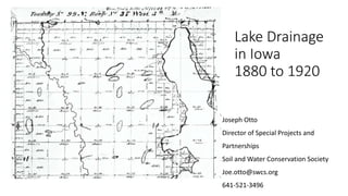
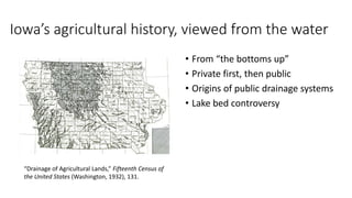
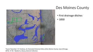
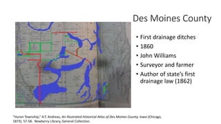
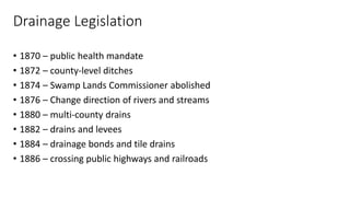
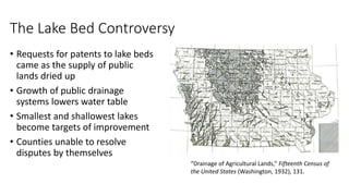
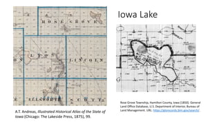
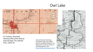
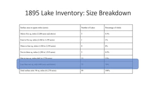
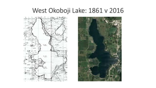
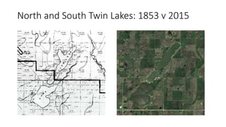
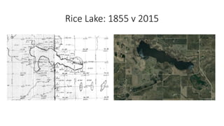
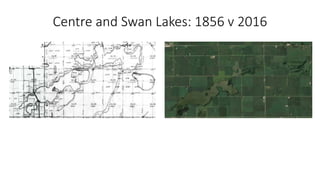
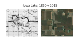
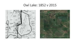
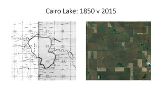
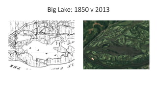
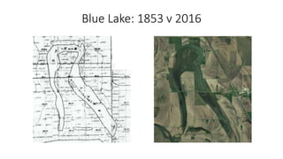
From 1880 to 1920, Iowa underwent extensive lake drainage as the demand for agricultural land grew. Private drainage efforts began in the 1850s and expanded, leading to the establishment of public drainage systems and laws governing drainage. This caused disputes over drained lake beds. A 1895 governor's proclamation ordered a survey finding 99 lakes covering 61,729 acres. Efforts to drain lakes were sometimes ruled unconstitutional or opposed by conservation groups wanting to preserve lakes, leading to the establishment of the State Board of Conservation in 1918 to protect remaining lakes.
The document summarizes key aspects of the Ohio River basin, including its geography, history of development and management, and future challenges. It notes that the Ohio River runs 981 miles and drains an area of over 200,000 square miles. It discusses how "presses" gradually alter the river system, while "pulses" like floods can suddenly transform it. Major historical developments include navigation improvements and flood control structures. Climate change poses uncertainties for managing future river presses and pulses.
Breakout Session Slides Pt. 1
Converging Ag Drainage with Water Quality – Mike Libben discusses how the Ottawa SWCD (Ohio) has blended the need for agricultural drainage and increased water quality for Lake Erie by integrating projects that accomplish both goals and brings partners together.
Tuesday, February 13, 1:30 - 2:10 p.m.
*Due to the size of the powerpoint, this was uploaded as three separate powerpoints. This is the first one, please continue to the next two for the full presentation*
The document summarizes the Confederated Tribes of Grand Ronde's presentation on their recently acquired property at the site of the former Blue Heron Paper Mill adjacent to Willamette Falls. It discusses:
- The Tribes' ancestral and treaty rights to lands surrounding the falls.
- Plans to remediate contamination at the site, invest in infrastructure, and develop a master plan focused on environmental restoration, public access, and thoughtful redevelopment while strengthening cultural connections.
- Securing an EPA brownfields grant to help fund cleanup activities and master planning over the next 3-5 years.
- The Tribe's vision is to restore the riverbank and channels, create open spaces, and redevelop the
The document provides an overview of the public process used to develop the Blueprint Jordan River vision. It involved workshops, focus groups, online surveys, and map analysis with over 1,000 community members. The key findings were that the public strongly supported a "green corridor" vision for the river with large natural buffers, habitat preservation, and multi-use trails for walking, biking, and other non-motorized recreation. Nature preserves and wildlife viewing areas were particularly important in the community's vision for the future of the Jordan River corridor.
This document provides a finding aid for the Elephant Butte Irrigation District records collection held at New Mexico State University Library's Archives and Special Collections Department. It summarizes the scope and contents of the collection, which documents the operations of the Elephant Butte Irrigation District from 1883-1981, including records related to water distribution, construction, finances, and interactions with government agencies. The collection is organized into nine series covering different aspects of the District's activities and departments.
The document provides an overview of the physical and human geography of the Intermontane West region of North America. It describes the varied topography including mountains, plateaus, and basins. Climate is generally arid or semi-arid. Native vegetation and wildlife are determined by elevation and precipitation levels. Population is distributed unevenly, concentrated near water sources for agriculture and around transportation hubs. Historical cultural geography involved indigenous groups, fur traders, miners, Mormons, railroads, and conflicts over land and water use. Growing urban areas face challenges around environmental issues and managing growth.
The document discusses the history of pollution and restoration efforts in the Willamette River in Oregon. It describes how the river was once declared an "open sewer" but water quality has improved due to various regulatory actions from the 1930s onward. However, the river and its fish populations still face threats including invasive species, pollution, and lack of access to cold water refuges during heat waves. Overall restoration progress depends on coordinated long-term efforts to improve habitat complexity and allow natural floodplain dynamics.
This report analyzes the historical landscape and ecology of Coyote Creek watershed before intensive human modification to understand how the area has changed and to identify opportunities for restoration. The report finds that historically the watershed contained a diverse mosaic of habitats including native grasslands, oak savanna, wet meadows, and freshwater wetlands. However, drainage intensification, agriculture, and development have significantly altered the watershed's hydrology and habitats. Understanding these historical conditions provides a basis for more appropriate restoration goals that consider recovering locally-adapted habitat types and restoring natural watershed functions.
WSI Lancaster County GIS Day, 11-08-2019SamuelFeibel1
This document discusses using lidar data and DEM differencing to map streambank erosion hotspots. It describes how high-resolution lidar data from 2008 and 2014 was used to identify areas along streambanks that experienced erosion during that period. Mapping of historic mill dams and legacy sediment deposits from previous dams was also described. The analysis was conducted at the municipal, HUC 10, HUC 12, and parcel scales to precisely locate erosion hotspots.
7 - Keep Tahoe Blue Lecture Spring semesteralicekazakov
Lake Tahoe is an oligotrophic alpine lake located on the border of California and Nevada. It was formed over 2 million years ago and is renowned for its deep blue waters and forested shoreline. However, human activities over the past century have accelerated the natural eutrophication process and reduced water clarity. Increased development, pollution from urban runoff, and the introduction of invasive species have all negatively impacted the lake's ecology. Ongoing restoration efforts focus on improving water quality and clarity through projects that reduce sediment and nutrient loading into the lake. The long-term goal is to restore Lake Tahoe's clarity to the historical depth of 97 feet.
Lake Tahoe is an oligotrophic alpine lake located on the border of California and Nevada. It was formed over 2 million years ago and is renowned for its deep blue waters and forested shoreline. However, human activities over the past century have accelerated the natural eutrophication process and reduced water clarity. Increased development, urban runoff, and the introduction of invasive species have all contributed to declining water quality. While efforts are underway to restore the lake and protect its clarity, balancing human use and environmental protection remains an ongoing challenge.
This is a presentation about water law in Idaho from the 1880s to the early 1900s. It covers the complexities of surface prior appropriation and usage rights. It accompanied a lecture at The Community Library by John Lundin.
Water in the Western United States - California: A Case StudyJonathan D'Cruz
California uses more water than any other state in the US
Each Californian uses an average of 181 gallons of water each day against the national average of 80-100 gallons each day
More water is used each day for irrigation than any other category
Total water use has been declining since the 1980s
California has been the state with the largest water use in the US since the USGS began compiling water-use data in 1950
Water resources and hydrology of californialschmidt1170
California's hydrology is complex, involving interactions between geology, climate, plants, animals, and humans. Geographers and hydrologists study these relationships and how water moves through watersheds, entering and exiting the system through precipitation, evaporation, runoff, and groundwater. They work to help manage water resources and improve living conditions. On average, 200 million acre-feet of water falls as precipitation in California each year, but human water diversions and projects have significantly altered natural hydrologic cycles and watersheds to supply water for urban and agricultural uses across the state.
Conflict over water resources: Colorado RiverGuerillateacher
The Colorado River Basin spans seven U.S. states and Mexico, with competing demands for water from agriculture, cities, and industry. During the 20th century, the river was dammed and diverted extensively through major infrastructure projects to supply water to over 25 million people. However, long-term drought and overallocation of water rights have led to conflicts as the river now rarely reaches the sea. Managing this vital resource equitably between multiple stakeholders remains an ongoing challenge.
This document summarizes Utah's water conservation legislation over the past decade. It discusses how House Bill 418 in 1998 required water retailers and districts serving over 500 connections to submit water conservation plans addressing 10 guidelines, including water efficient appliances and fixtures, irrigation practices, leak repair, and water rate structures. It evaluates several municipalities' conservation plans, finding that larger cities like Salt Lake City had more detailed plans while smaller cities also included rate incentives and conservation measures. The legislation and conservation planning aimed to ensure sufficient water for Utah's growing population amidst increasing drought periods.
This document provides a summary of water conservation legislation and efforts in Utah over the past decade. It discusses how House Bill 418 in 1998 and House Bill 71 in 2004 required municipalities and water districts to develop water conservation plans with specific guidelines. An analysis found that implementation of recommended water conservation practices increased from 1998-2009. For example, the use of low-flow fixtures and outdoor watering restrictions grew. The legislation and subsequent conservation efforts were aimed at ensuring sufficient water supplies for Utah's growing population in the face of limited water resources and drought.
The Yadkin and Pee Dee River Basin starts in the mountains and flows through the piedmont, containing 5,862 total miles of streams and rivers across its 7,221 square mile area. Major rivers include the Yadkin and Pee Dee Rivers, while tributaries comprise the Mitchell, Ararat, Uwharrie, Rocky, Dutchmans, Long, and Abbots Creek. The basin is home to 30 rare aquatic species, two of which are federally endangered.
Overview of the Wappinger Creek & Watershed BasicsSean Carroll
This document discusses watersheds and the Wappinger Creek watershed. It begins by defining a watershed as the area of land where all water drains to the same place. It then provides an overview of the Wappinger Creek watershed, including its size, towns located within it, and details about Wappinger Creek itself. The document discusses land use in the watershed and impacts of development, agriculture, and lack of riparian buffers. It concludes by explaining the benefits of a watershed-scale approach to planning and management, including integrating multiple stakeholders and programs.
The Broad River basin originates in the mountains of western North Carolina and flows southeast through the foothills and Piedmont region into South Carolina, covering over 1,500 square miles. Major tributaries include the Green, First Broad, Second Broad, and North Pacolet rivers, and cities like Kings Mountain, Shelby, and Forest City obtain their water from the basin. The basin contains over 100,000 acres of public and private land home to rare plants and animals and is a popular area for hiking, tubing, and other outdoor recreation activities.
The Broad River Basin:
- Originates in the mountains of western North Carolina and flows southeast through the piedmont region.
- Contains over 100,000 acres of public and private land with rare plants and animals.
- Provides water to cities like Kings Mountain, Shelby, and Forest City across multiple counties.
Lecture - Chapter 14 - Water as a Limited Resource.pptSomyaKulshrestha10
This chapter discusses water as a limited resource and various issues related to water quantity and quality. It covers the importance of water, properties of water, the hydrologic cycle, distribution and types of freshwater, and water use problems including too much water (flooding), too little water (drought), and poor water quality. Methods of water management are also summarized, including dams and reservoirs, water diversion projects, desalination, and conservation efforts. Global water issues like population growth, climate change, and sharing water resources between countries are also addressed.
Treasuring the Trinity: Challenges and OpportunitiesTrinity Waters
The Trinity River supplies water to 45% of the Texas population, making it perhaps the most important river basin in Texas. Water quality issues have challenged this river, as well as drought, land fragmentation and habitat loss. Trinity Waters and AgriLife Extension are working with partners to promote land stewardship to improve landowner quality of life and water supplies by connecting urban resources back into the watersheds that support them.
The document summarizes the Kansas River Watershed Enhancement Initiative. It discusses the goals of building awareness of the cultural and natural resources of the Kansas River Valley through consensus building and grassroots partnerships. It highlights various projects and organizations working to improve water quality, including the Kaw Valley Heritage Alliance, stream teams, and efforts around the Wakarusa River and Clinton Lake watersheds.
"Engaging Diverse Communities in Social Ecological Restoration: The Mysterious and Inspiring Case of the Klamath Basin Agreements" presented by Dr. Hannah Gosnell on June 19 to the 2014 PI Works! conference in Bend, Oregon.
The document discusses water stress in Arizona due to limited groundwater supplies and a historic drought reducing the flow of the Colorado River. It outlines how the state established Active Management Areas and set a goal to achieve safe yield of groundwater by 2025 through the 1980 Groundwater Management Act. However, the latest data shows most areas remain far from safe yield with continued aquifer declines. The Central Arizona Project was built to bring Colorado River water to 80% of the state's population, but the river is increasingly overused and drying up due to climate change. Future projections of water availability and use under different socioeconomic scenarios are needed to cope with the growing impacts of the climate crisis on Arizona's water supply.
The document summarizes the journey of the Mississippi River from its source at Lake Itasca in Minnesota to its mouth at the Gulf of Mexico. It describes the river's source as clear water where you can wade across. It also tells the legend of Paul Bunyan creating Lake Itasca and the Mississippi River. Additionally, it mentions how development has damaged wetlands and contributed to their disappearance of 25 square miles per year in the Mississippi River delta region.
This document summarizes a presentation about using process models to help build trust and understanding when implementing edge of field conservation practices. It discusses how process models can help various stakeholders like conservation professionals, landowners, cities, and contractors understand the time and resources required. It provides examples of process models created for constructed wetlands, saturated buffers, and bioreactors. The presentation discusses the goals of helping more stakeholders and expanding the models, as well as thanking collaborators on the project.
This document discusses the challenges of meeting nitrogen reduction goals in the Upper Mississippi River Basin. It notes that meeting the nutrient reduction goals will be a massive effort that requires a mix of practices across Iowa, Minnesota, and Illinois, including wetlands, drainage treatment, and stacked practices. However, there are also many challenges to implementing the necessary practices, including economics, human/social factors, delivery challenges, risk management, climate change, and the need for further research. The document emphasizes that understanding the large scale of the challenge is needed to make progress toward the nutrient reduction goals.
The document summarizes a meta-analysis that compared the nitrate removal performance of different substrates used in denitrifying bioreactors. It found that wood media had the highest nitrate removal rate (NRR) and percentage (NRE), followed by mulch media, nutshell-based media, and inorganic media. However, when considering cost-effectiveness, woodchip and corn cob were the most economical natural organic carbon substrates. Overall, the analysis suggests that mulch media is the optimal material for nitrate removal due to its low cost and potential to overcome deficiencies in other media types.
The document summarizes an investigation into phosphorus transport dynamics in subsurface drainage using high-frequency measurements. Key findings include:
1) TRP concentration had a dynamic pattern that was strongly influenced by drainage discharge levels, highlighting the need for high-resolution sampling.
2) Event flows contributed 78% of the total TRP load despite comprising only 50% of total flow.
3) Flow-proportional sampling strategies provided more accurate TRP load estimates than time-proportional strategies and were more cost-effective. Targeting high flow periods is important for reducing phosphorus loss.
This document summarizes a study that evaluated a procedure for prioritizing maintenance of agricultural drainage ditches. The study measured the critical shear stress of soils using a cohesive strength meter to assess their susceptibility to erosion. Soils with higher root densities and those treated with mixed lime showed higher critical shear stresses, meaning they were less susceptible to erosion. Measurements of pressure on the soil surface during testing were mostly lower than estimates from other studies. The procedure effectively identified the relative erosion resistance of different soils, aiding prioritization of drainage ditch maintenance needs.
ISG worked with Blue Earth County to digitize and modernize their drainage data. They georeferenced existing plans, digitized drainage features, attributed data to the digitized features, and created a geodatabase to house the updated drainage data. This project consolidated Blue Earth County's drainage records, improved data accuracy, and established a process for ISG and the County to regularly update the drainage data going forward. The updated digital records will benefit Blue Earth County, ISG, other engineering firms, and the public.
This document summarizes the results of Latvia's long-term Agricultural Runoff Monitoring programme, which aims to document nutrient concentrations and losses at different spatial and temporal scales. The monitoring covers groundwater, experimental drainage plots, subsurface drainage fields, small catchments, and small/medium rivers at 23 sites. Results show discharge and nutrient concentration data varying by location, scale of monitoring, and between years with flooding or drought. Nutrient levels differed between the Berze and Mellupite monitoring sites and across groundwater, drainage plots, and catchment scales. The programme provides long-term data on agricultural nonpoint source pollution across Latvia.
This document summarizes an applied research and demonstration project evaluating soil and water management practices in undulating soils in southwestern Manitoba. The project aims to reduce nitrogen, phosphorus and salt export while improving drought resiliency. Preliminary results show tile drainage is lowering water tables most in lower landscape positions, with soil moisture responding rapidly in drained areas. Tile flow rates increase with decreasing elevation. Water quality measurements also show higher salt concentrations in lower positions. Next steps include water quality treatment analysis, long-term monitoring, modeling, knowledge transfer and reporting.
This document summarizes a coordinated research network studying the impacts of 4R nutrient stewardship practices on crop yields, soil health, and nutrient losses across sites in North America. The network included 8 research sites across 6 states/provinces from 2017-2020. Treatments included different fertilizer application timings, placements, sources, and rates. Standardized data collection allowed comparisons across sites. Preliminary findings showed 4R and advanced 4R practices improved nutrient use efficiency and reduced nitrogen losses while maintaining crop yields. Nitrous oxide emissions and nitrate leaching losses decreased under improved nutrient management, though impacts varied between sites and years. Ongoing research aims to further quantify environmental benefits and optimize fertilizer practices.
The document summarizes research on managing drainage water in the Holland Marsh region of Ontario to improve water quality and agricultural productivity. Key points:
- The Holland Marsh is an important vegetable growing region on organic soils, but drainage into Lake Simcoe contributes excess nutrients.
- A study evaluated controlling water tables with controlled drainage to reduce pumping and nutrient loads in drainage water. Modeling and monitoring found it effective for water conservation but more limited for nutrient reductions.
- Soil phosphorus pools, particularly aluminum and iron-bound phosphorus, were found to influence phosphorus levels in drainage water more than drainage management alone. Fertilizer applications exceeded crop needs, accumulating legacy phosphorus in soils over time.
This document summarizes a study comparing the effects of conventional ditch drainage (FD) and shallow furrow drainage with tile (SD) on crop yields and water quality in eastern North Carolina. Preliminary results found that SD led to a 68% reduction in drainage volume, 80% less nitrate export, and higher average soybean (+9.1%) and corn (+3.7%) yields compared to FD. SD also requires less land area than FD, has lower maintenance needs, and shows potential to improve water quality and agricultural productivity with more efficient drainage management. The research aims to further quantify these impacts of SD drainage design.
1) DRAINMOD simulations were conducted for a field in Harrow, Ontario with an asymmetrical drainage system to determine the best approach to simulate drain outflow. 2) Four approaches using different drain spacings were tested: 3.8m, 5.06m, 7.6m, and 15.2m. 3) The mean absolute error and root mean square error for each approach were acceptable, indicating drain spacing had little impact on outflow simulation, though it did impact soil moisture parameters.
This document discusses how the choice of pipe material influences drain spacing and system cost. It finds that pipe with more rows of perforations, such as an 8-row regular perforated pipe, has a higher effective radius than a 4-row pipe, allowing for wider drain spacing. Experiments show that a sock-wrapped pipe has the highest drain inflow of the pipes tested, both with and without drain sedimentation present. The key takeaways are that the number of perforation rows and slot length most impact effective radius and drain flow, and a sock-wrapped pipe performs best in terms of drain inflow and spacing.
This document summarizes research conducted by the Plastics Pipe Institute (PPI) on the installation of corrugated high-density polyethylene (HDPE) and polypropylene (PP) agricultural drainage pipe. It describes field testing of 30-inch HDPE dual-wall pipe installed at a test site in Ohio, including instrumentation to monitor strain and deflection. Finite element modeling was also used to analyze trench configurations. The research aims to update industry guidance documents to optimize pipe installation practices and trench designs. PPI members also work to increase the use of recycled HDPE and PP materials in pipe production.
The document discusses Ohio's H2Ohio water quality initiative and its funding of conservation practices including two-stage ditches. It launched in 2019 with $172 million to reduce phosphorus runoff from farms using best management practices like wetlands, buffers, and two-stage ditches. A $5 million grant program was announced to fund two-stage ditch projects based on design guidelines. The document provides details on the grant application process, design requirements using regional curves, and goals to fund 20 projects for 30 miles of ditches at $30 per foot on average.
This document provides information on edge-of-field conservation practices and a panel discussion on drainage ditches. It summarizes various practices for nutrient, soil, and sediment removal including vegetated buffers, grassed waterways, prairie strips, wetlands, bioreactors, and controlled drainage. Cost effectiveness data is given for each. The key elements of an edge-of-field roadmap are outlined as building the economic case, increasing implementation capacity, and elevating a culture of conservation. A sample conservation planning scenario shows identified sites for practices treating over 9,000 acres of land. The document concludes with information on connecting with The Nature Conservancy's Ohio agriculture programs.
This document discusses the implementation and maintenance of two-stage ditches. Two-stage ditches incorporate a floodplain area to increase flow capacity while slowing velocities. They allow for channel vegetation, improve sediment settling, and provide water quality benefits. Challenges include obtaining land access, communication with landowners, permitting, and planting/erosion control. Case studies of implemented two-stage ditch projects in Lucas County demonstrate post-construction conditions and results, including improved drainage and yields for agriculture.
This document summarizes research on conservation channel design and sediment capture in two-stage ditches. It finds that self-forming channels accumulated more sediment, carbon, nitrogen, and phosphorus over time compared to traditional ditches. Sediment analysis showed higher nutrient levels than surrounding soils. A case study site captured over 500 kg of phosphorus over 9 years that could be harvested and reused as fertilizer, offsetting nutrient costs for farmers. The document concludes sediment trapping in two-stage ditches can improve water quality while providing a locally sourced, cost-effective fertilizer resource.
Farmers, drainage contractors, researchers, and conservation authorities collaborated on a drainage innovation project at Huronview in Clinton, Ontario. They worked together on the design, installation, and monitoring of new drainage practices to improve water quality and sustainability while maintaining agricultural productivity. A demonstration day was held in June 2019 to share results with stakeholders. The project aimed to foster cooperation across sectors and balance priorities around drainage, research, environmental protection, and social acceptance.
This document summarizes a study on the impact of drainage water recycling (DWR) on nutrient and sediment losses from agricultural fields in eastern North Carolina. The study found that storing drainage water in an on-farm reservoir for supplemental irrigation (DWR) significantly reduced nitrogen, phosphorus, and sediment concentrations and loads compared to a non-irrigated control field. Specifically, DWR reduced total nitrogen concentration by 40% and load by 47%. It also reduced total phosphorus concentration by 21% and load by 30%. Sediment concentration was reduced by 86% and load by 87%. The hydraulic retention time in the reservoir was found to be the major factor influencing nutrient and sediment removal efficiency.
More from Soil and Water Conservation Society (20)
Kinetic studies on malachite green dye adsorption from aqueous solutions by A...Open Access Research Paper
Water polluted by dyestuffs compounds is a global threat to health and the environment; accordingly, we prepared a green novel sorbent chemical and Physical system from an algae, chitosan and chitosan nanoparticle and impregnated with algae with chitosan nanocomposite for the sorption of Malachite green dye from water. The algae with chitosan nanocomposite by a simple method and used as a recyclable and effective adsorbent for the removal of malachite green dye from aqueous solutions. Algae, chitosan, chitosan nanoparticle and algae with chitosan nanocomposite were characterized using different physicochemical methods. The functional groups and chemical compounds found in algae, chitosan, chitosan algae, chitosan nanoparticle, and chitosan nanoparticle with algae were identified using FTIR, SEM, and TGADTA/DTG techniques. The optimal adsorption conditions, different dosages, pH and Temperature the amount of algae with chitosan nanocomposite were determined. At optimized conditions and the batch equilibrium studies more than 99% of the dye was removed. The adsorption process data matched well kinetics showed that the reaction order for dye varied with pseudo-first order and pseudo-second order. Furthermore, the maximum adsorption capacity of the algae with chitosan nanocomposite toward malachite green dye reached as high as 15.5mg/g, respectively. Finally, multiple times reusing of algae with chitosan nanocomposite and removing dye from a real wastewater has made it a promising and attractive option for further practical applications.
Evolving Lifecycles with High Resolution Site Characterization (HRSC) and 3-D...Joshua Orris
The incorporation of a 3DCSM and completion of HRSC provided a tool for enhanced, data-driven, decisions to support a change in remediation closure strategies. Currently, an approved pilot study has been obtained to shut-down the remediation systems (ISCO, P&T) and conduct a hydraulic study under non-pumping conditions. A separate micro-biological bench scale treatability study was competed that yielded positive results for an emerging innovative technology. As a result, a field pilot study has commenced with results expected in nine-twelve months. With the results of the hydraulic study, field pilot studies and an updated risk assessment leading site monitoring optimization cost lifecycle savings upwards of $15MM towards an alternatively evolved best available technology remediation closure strategy.
Improving the viability of probiotics by encapsulation methods for developmen...Open Access Research Paper
The popularity of functional foods among scientists and common people has been increasing day by day. Awareness and modernization make the consumer think better regarding food and nutrition. Now a day’s individual knows very well about the relation between food consumption and disease prevalence. Humans have a diversity of microbes in the gut that together form the gut microflora. Probiotics are the health-promoting live microbial cells improve host health through gut and brain connection and fighting against harmful bacteria. Bifidobacterium and Lactobacillus are the two bacterial genera which are considered to be probiotic. These good bacteria are facing challenges of viability. There are so many factors such as sensitivity to heat, pH, acidity, osmotic effect, mechanical shear, chemical components, freezing and storage time as well which affects the viability of probiotics in the dairy food matrix as well as in the gut. Multiple efforts have been done in the past and ongoing in present for these beneficial microbial population stability until their destination in the gut. One of a useful technique known as microencapsulation makes the probiotic effective in the diversified conditions and maintain these microbe’s community to the optimum level for achieving targeted benefits. Dairy products are found to be an ideal vehicle for probiotic incorporation. It has been seen that the encapsulated microbial cells show higher viability than the free cells in different processing and storage conditions as well as against bile salts in the gut. They make the food functional when incorporated, without affecting the product sensory characteristics.
Optimizing Post Remediation Groundwater Performance with Enhanced Microbiolog...Joshua Orris
Results of geophysics and pneumatic injection pilot tests during 2003 – 2007 yielded significant positive results for injection delivery design and contaminant mass treatment, resulting in permanent shut-down of an existing groundwater Pump & Treat system.
Accessible source areas were subsequently removed (2011) by soil excavation and treated with the placement of Emulsified Vegetable Oil EVO and zero-valent iron ZVI to accelerate treatment of impacted groundwater in overburden and weathered fractured bedrock. Post pilot test and post remediation groundwater monitoring has included analyses of CVOCs, organic fatty acids, dissolved gases and QuantArray® -Chlor to quantify key microorganisms (e.g., Dehalococcoides, Dehalobacter, etc.) and functional genes (e.g., vinyl chloride reductase, methane monooxygenase, etc.) to assess potential for reductive dechlorination and aerobic cometabolism of CVOCs.
In 2022, the first commercial application of MetaArray™ was performed at the site. MetaArray™ utilizes statistical analysis, such as principal component analysis and multivariate analysis to provide evidence that reductive dechlorination is active or even that it is slowing. This creates actionable data allowing users to save money by making important site management decisions earlier.
The results of the MetaArray™ analysis’ support vector machine (SVM) identified groundwater monitoring wells with a 80% confidence that were characterized as either Limited for Reductive Decholorination or had a High Reductive Reduction Dechlorination potential. The results of MetaArray™ will be used to further optimize the site’s post remediation monitoring program for monitored natural attenuation.
1. Lake Drainage
in Iowa
1880 to 1920
Joseph Otto
Director of Special Projects and
Partnerships
Soil and Water Conservation Society
Joe.otto@swcs.org
641-521-3496
2. Iowa’s agricultural history, viewed from the water
“Drainage of Agricultural Lands,” Fifteenth Census of
the United States (Washington, 1932), 131.
• From “the bottoms up”
• Private first, then public
• Origins of public drainage systems
• Lake bed controversy
3. “Huron Township,” A.T. Andreas, An Illustrated Historical Atlas of Des Moines County, Iowa (Chicago,
1873), 57-58. Newberry Library, General Collection.
Des Moines County
• First drainage ditches
• 1850
4. • First drainage ditches
• 1860
• John Williams
• Surveyor and farmer
• Author of state’s first
drainage law (1862)
“Huron Township,” A.T. Andreas, An Illustrated Historical Atlas of Des Moines County, Iowa (Chicago,
1873), 57-58. Newberry Library, General Collection.
Des Moines County
5. Drainage Legislation
• 1870 – public health mandate
• 1872 – county-level ditches
• 1874 – Swamp Lands Commissioner abolished
• 1876 – Change direction of rivers and streams
• 1880 – multi-county drains
• 1882 – drains and levees
• 1884 – drainage bonds and tile drains
• 1886 – crossing public highways and railroads
6. The Lake Bed Controversy
• Requests for patents to lake beds
came as the supply of public
lands dried up
• Growth of public drainage
systems lowers water table
• Smallest and shallowest lakes
become targets of improvement
• Counties unable to resolve
disputes by themselves
“Drainage of Agricultural Lands,” Fifteenth Census of
the United States (Washington, 1932), 131.
7. A.T. Andreas, Illustrated Historical Atlas of the State of
Iowa (Chicago: The Lakeside Press, 1875), 99.
Iowa Lake
Rose Grove Township, Hamilton County, Iowa (1850). General
Land Office Database, U.S. Department of Interior, Bureau of
Land Management. URL: https://glorecords.blm.gov/search/.
8. Owl Lake
A.T. Andreas, Illustrated
Historical Atlas of the State of
Iowa (Chicago: The Lakeside
Press, 1875), 50.
Lake and Norway Townships,
Humboldt County, Iowa (1852).
General Land Office Database, U.S.
Department of Interior, Bureau of
Land Management. URL:
https://glorecords.blm.gov/search/
.
9. A.T. Andreas, Illustrated Historical Atlas of the State of
Iowa (Chicago: The Lakeside Press, 1875), 99.
Cairo Lake
Hamilton and Lyon Townships, Hamilton County, Iowa (1850).
General Land Office Database, U.S. Department of Interior,
Bureau of Land Management. URL:
https://glorecords.blm.gov/search/.
10. Governor’s Office Intervenes
• 1895 - Governor Jackson’s
Proclamation
• Orders survey of all
meandered lakes
Report of the Secretary of State to the
Governor of Iowa, of the Transactions of the
Land Department, July 1, 1895 (Des Moines,
1895). URL.
The policy of the State should be to maintain all the
lakes of Iowa in their original extent and beauty,…To
convert them into fields for cultivation, appears to me
to be utilitarianism run mad…If, by any means, the
lakes of Iowa can be preserved, it should by all means
be done. A person who drains the lakes commits a
public wrong.
-Milton Remley, Attorney General, State of Iowa
Summer, 1895
Milton Remley to Frank Jackson, June 22, 1895, Attorney General Correspondence: Lands,
Islands, and Lake Beds, 1889-1924. Box 1. DM RG 080. State Archives of Iowa, State
Historical Society of Iowa. Des Moines, Iowa.
11. • 1895-1904: Lakes survey – Governor’s Office
• 99 lakes covering 61,729 acres
• Legislature and Governor reviewed petitions to drain/lease lakes
• 1904-09: period of change
• Drainage law ruled unconstitutional
• Constitutional amendment passed
• 1909-11: State Drainage, Waterways, and Conservation Commission
• USDA Office of Drainage Investigations surveys conditions
• Recommends permanent conservation commission, est. state engineer office,
upstream/downstream management districts
• Discontinued by state legislature
• 1915: Lakes Survey – State Highway Commission + State Engineer
• 68 lakes covering 44,553 acres (others ordered drained by legislature)
• 1918-19: State Board of Conservation est.
• Forerunner to Iowa DNR
• 31 lakes recommended sites for state parks
Management of Iowa’s lakes
12. Research Opportunities
• Holding capacity studies of drained prairies
• Historic erosion benchmarks from surveyor journals
• Moving beyond the pre-agricultural, before/after comparison
• Identifying target areas for reconstructed wetlands / oxbows
• History of county-state-federal jurisdictional relationships
• Public history of drainage infrastructure and law
• Some good stories to tell
13. Lake Drainage
in Iowa
1880 to 1920
Joseph Otto
Director of Special Projects and
Partnerships
Soil and Water Conservation Society
Joe.otto@swcs.org
641-521-3496
END
14. 1895 Lake Inventory: Size Breakdown
Surface area in square miles (acres) Number of Lakes Percentage of whole
Above five sq. miles (3,200 acres and above) 5 4.5%
Four to five sq. miles (2,560 to 3,199 acres) 1 1%
Three to four sq. miles (1,920 to 2,559 acres) 0 0%
Two to three sq. miles (1,280 to 1,919 acres) 5 4.5%
One to two sq. miles (641 to 1279 acres) 13 13%
Less than one sq. mile (640 acres and below) 75 76%
Total surface area: 98 sq. miles (61,270 acres) 99 100%
15. Not all lakes recorded
A.T. Andreas, Illustrated Historical Atlas of the State of
Iowa (Chicago: The Lakeside Press, 1875), 181.
Polk County – Dean and Horseshoe Lakes
A.T. Andreas, Illustrated Historical Atlas of the State of Iowa
(Chicago: The Lakeside Press, 1875), 45.
Hancock County – George and Edward Lakes
16. Group 1 of 4: Large Lakes
• Deep water capable of supporting fish life year-round, functioned as a
state-wide tourist destination. Protected by state at an early date,
drainage an impossibility and never attempted.
19. Group 2 of 4: Medium Lakes
• Same as large lakes, but functioned as a county-wide tourist
destination. Drainage attempted, sometimes successfully and
sometimes not. For some, locals organized to protect its value as a
tourist or outdoor recreation attraction, thereby leading to state
stewardship. For others, drainage attempts were partially successful,
thereby reducing the lake’s surface area. Still for others, drainage was
a failure, yet the lake nonetheless lost its lake-like qualities because of
drainage to adjacent farmland.
23. Group 3 of 4: Small Lakes
• Naturally shallow, during drought can be reduced to swamp-like
conditions or dry up altogether. Spatial and temporal variability made
them unable to support fish life year-round, yet because they were
part of a larger hydrological environment, they supported fish
population as spawning grounds. The most numerous of the three
groups, yet the least protected from drainage. Local governments
asserted control over them at an early date. Commonly enveloped by
private land and discreetly drained over a number of years. State
attempts at stewardship were minimal, if not absent altogether.
• Made up ¾ of all the state’s natural lakes
27. Group 4 of 4: Riverine Lakes
• Unlike the lakes in the other three categories, these lakes were
formed in the bottomlands of the Mississippi and Missouri Rivers. On
the east and west borders of Iowa, these lakes formed at the mouth
of the state’s interior rivers.
30. Lake Drainage
in Iowa
1880 to 1920
Joseph Otto
Director of Special Projects and
Partnerships
Soil and Water Conservation Society
Joe.otto@swcs.org
641-521-3496
END
Editor's Notes
Iowa’s history, and much of the Midwest’s, is tied to the transformation of the tallgrass prairies into fields of crops. When we think about Iowa’s natural advantages for crop production (fertile soil, moisture content, climate), it becomes almost second nature to see the emergence of row crop agriculture as an inevitability. Viewed from the land, anyway. But history is way messier than that! Especially when you bring water into the equation – the story gets a lot muddier (pause).
By looking at Iowa’s history through the lens of water management – the story gets a lot muddier, and a lot more interesting. Iowa was and still is a very wet place – and creating optimal crop growing conditions across its varying geography means finding a way to manage that water. Drainage systems allow us to do that, and are the reason Iowa looks the way it does. In that sense, understanding how drainage systems started, expanded, and changed over time, helps us gain a better understanding of why Iowa looks the way it does, and more importantly, the constant human effort required to keep it looking like it does.
Iowa was settled from bottom to top – the river valleys and sloping hillsides were cultivated first, while the headwaters of the rivers came much later. The transition from prairie to corn belt followed the same trajectory – you wanted to be close to water, but not too close. Land is a finite resource, and after the best lands were purchased and cultivated, people seeking lands to improve into farms turned their attention to the less desirable, wetter, lands, that required more effort to improve – hard labor digging ditches and draining swamps, BEFORE the hard labor of turning the soil and sowing crops.
Origins of the word pioneer – pioneer was a French military term for soldiers whose job it was to dig ditches.
And because digging ditches is extremely hard and costly work, it was avoided as much as possible. Early farmers dug their own ditches or hired small outfits to run draglines and scrapers, pulled by teams of horses, to cut shallow ditches through their lands. As the prairies became more settled and populated, collaborations with neighbors became possible. Still hard work, but many hands make for lighter work. A ditch that ran freely across property lines was also more functional and effective.
The first drainage ditches in Iowa were dug in the late 1850s – along the Mississippi River in what is now Des Moines County, north of the city of Burlington. Burlington was Iowa’s first capital city, having been the territorial capital of Wisconsin Territory in the 1830s, before newcomers in Iowa organized their own territorial government which was sited in Iowa City, and Wisconsin’s capital was sited at Madison. (Fun trivia – Burlington as the first capital of Iowa and Wisconsin).
The Anglo Americans coming into Iowa were from New England – hence naming their capital Burlington, after the city in Vermont on Lake Champlain, and they were steeped in frontier lore and literature about the French and Indian Wars, hence their being nicknamed “Hawkeyes,” after the mythic frontier character from the novels of James Fenimore Cooper, who wrote Last of the Mohicans in the 1820s, as part of a set of novels about the European settlement of North America. These books were not historically accurate, but the people coming into Iowa before the Civil War would have been steeped in those stories since childhood.
And when they grew up, moved west, found jobs, and bought land, draining swamps became part of their daily routines.
On your screen is a map of Huron Township in Des Moines County. The blue areas are riverine swamps, and the green areas mark the lands of a person named John Williams. Williams was from Vermont and moved to Iowa in the 1850s, after having worked for the federal government as a surveyor of swamp lands in the upper Mississippi River valley. Between 1850 and 1860 Williams improved his lands and gradually built a farm on top of the low lying swamps along the main river channel.
Fast forward to the 1870s, and you can see that Williams expanded his holdings, which he connected by a series of drainage ditches that are highlighted in red – running from one water body to the next, providing him an outlet at the Mississippi River. Williams was an experienced surveyor and lowland farmer who well-suited to this sort of project. In fact it gained him notoriety as a drainage authority – while serving in the state legislature he authored the state’s first drainage law in 1862.
National Register of Historic Places – Iowa’s first drainage ditch!
This is the origin point of Iowa’s public drainage infrastructure – built as a supplement to existing private infrastructure, in order to relieve farmland of flooding and provide an outlet for excess water.
And more legislation followed. After the Civil War Iowa’s legislature actively considered drainage bills every session. In 1870 the legislature passed a law that required any public drainage system promote the public health, convenience, and welfare. Then they allowed counties to hold general elections where the entire voting public voted on large drainage projects just like they voted for a senator or for the president. In the 1880s the laws changed again, allowing for multi-jurisdiction drainage projects that crossed county lines, the construction of levees, and the financing of projects through the sale of public bonds. And in 1884 the law changed again to distinguish open ditches from tile drains, which were becoming more prevalent.
Not surprisingly, the growth of drainage laws accelerated drainage activity. Particularly the 1884 law that allowed for the sale of bonds. In order to differentiate one project’s bonds from another, the projects were identified as separate drainage districts, having their own budget, tax assessments, repayment schedules, and contracts. After that the legislature added provisions that allowed drains to cross public highways and railroads, which led to tensions over how to levy taxes against roads and railways that were impacted by drainage activity.
By the 1880s, people had settled Iowa’s river valleys and had entered the headwaters and started farming those wetter prairies as well. And while this went on, the state’s drainage laws changed into their modern form, which I define as the county and district system. With county governments as the chief administrators, or trustees, of drainage districts, with the elected board of supervisors as the executive body. Everything became centralized in Iowa’s courthouses – just as it does today.
Remember when I said that the story gets muddy? Well, put on your boots and maybe even your chest waders if you got em, because in the 1890s a drainage conflict, or a series of conflicts, rather, emerge that I call the Lake Bed Controversy. The conflict was about how to use Iowa’s natural lakes – should they be managed to conserve their water resources, or should they be managed to conserve their soil resources. The former meant preserving them as lakes for fish and game animals, as scientific sites to study native prairie flora and fauna, and as sites of recreation, for picnics, camping, and tourism. The latter meant removing the excess water in order to access the fertile prairie soils making up the lake beds.
The Lake Bed Controversy started in the headwater counties of north central and northwest Iowa, where most of Iowa’s natural lakes are located.
As people came into the headwater prairies, they began the process of building drainage systems. Small, private ditches connected to one another, which were in turn connected to public ditches and tile mains. The broader impact was a gradual lowering of the water table, which naturally impacted Iowa’s lakes to varying degrees. The larger and deeper a lake was, the less it was impacted by drainage activity. So the controversy emerged around the smallest and shallowest lakes, of which there were many more of.
The controversy comes from the fact that draining lakes was seen by some as a poor and even illegal use of public funds. By law public drainage projects had to promote the public welfare, which up to that point had been a non-issue. It was assumed and widely accepted that drainage was a public good – it improved soil and allowed for more prosperous and stable farming. Opposition to a specific drainage project was not uncommon to dispute a boundary, a benefit classification, or a ditch route – drainage trustees dealt with these conflicts regularly and still do. But new conflicts emerged over whether or not Iowa’s drainage law applied to lake beds, which legally were public bodies of water that could not be owned, let alone bought, sold, or taxed. Counties generally assumed they were in the right and plowed ahead with procedure, while opponents began writing letters to the governor and the state attorney general.
One cause of the controversy was the presence of land speculators looking for investments. It was not uncommon for land newly organized into a drainage district to rise in value. Lake beds were no different. Let me explain how it worked with an example of Iowa Lake in Hamilton County.
December 1894: a Des Moines banker tries to buy the lake bed. $4500 + $1275 = $5775 for both lakes (814 and 160 acres = 974) $6.31 per acre.
A legal battle ensues – not over the right to sell the lakes, but the manner in which he paid. He paid for the small one up front, but not the big one. The BOS refused to issue the deed for the small one until the big one was also paid for, arguing that it was a package deal. Because he failed to buy both at the same time, he had no right to the deed of either.
Long then sues Hamilton County. 6 months later, in April 1895, the district court rules in favor of Long, Hamilton County ordered to issue the deeds.
Hamilton County appeals to the Iowa Supreme Court.
October 1895: While the court case was pending, Long suddenly shows up at the courthouse with all the money. He brought $4000 in gold and $500 in currency. The County Treasurer refuses to accept it.
Long sues the county again, demanding that they honor the original package deal contract. The argument being that the county accepted his bid for the lake bed lands, which constituted a contract.
January 1896: 3 months later. The BOS issues the deeds to Long, who immediately transfers them to another investor – W.J. Chamberlain, another banker. State Bank of Jewell.
One month later, in February of 1896, Chamberlain sells the title of the small lake, Island, to another investor. 160 acres. Sold for $5360. $33.50 per acre. %430 increase in price.
In a span of 14 months, these lakes changed hands four times, and were involved in three lawsuits. Nothing about the lake beds changed physically at that time. Nobody drained them or grew a crop on them. It was purely about speculation.
Railroad investor near Fort Dodge in Webster County. Bought up land all around the bed of Owl Lake to make a giant hobby farm. Brought in an experimental ditching machine to do the work. Was highly publicized in the local newspapers – captain of industry.
Cairo Lake in Hamilton County. 1895 – about 5 years after Owl Lake
David Kent – Professor at Iowa State. Impressed with Owl Lake and wanted to try it for himself.
1895 – acquires from county for $5000, or $3.16 per acre.
Sinks a small fortune into it, secures outside capital from a speculator. Manages to partially drain the lake and raise some watermelons.
1898 – heavily in debt, loses his property to the speculator
1900 – Cairo Lake bought for $30,000 by Charles Rand Estate. $18.90 per acre. %498 increase.
After 1900 – Kent is hired by Rand Estate to manage the farm. Succeeds in organizing a drainage district. Lake is gradually drained between 1909 and 1915.
What was different about Cairo Lake?
The Cairo Lake case is important because it was the last meandered lake to be sold off this way.
Cairo Lake was nearer the urban centers of Des Moines and Ames. Legislators and professors came out publicly against the project and urged the county supervisors to stop what they were doing.
A horticulture professor at Iowa State, Joseph Budd, called the idea “a burning shame” and worried that removing the lake would make the area more susceptible to drought. Moreover, he thought the lake was “one of the most beautiful lakes of northern Iowa,” and that instead of draining lakes, “thousands more should be made over all parts of the state.”
Legislator and historian Charles Aldrich saw it as bad business. He criticized local officials for foolishly and shortsightedly parting with their only natural tourist attraction.
“If the county could not improve her lakes just now there can be little doubt that she could do so in the future. It could easily have been a summer resort for hundreds of people who cannot go to the greater lakes.”
Aldrich knew that locals valued the lake as a recreation and beauty spot. Residents described Cairo Lake as a “fine body of water, abounding in fish,” and an ideal site for a party.
Over the years it hosted a number of celebrations, including Fourth of July festivals and mass-baptisms. Destroying the lake for the personal gain of one man appeared to some to be unethical and very much against the public interest. Just because a county had public lands on hand did not mean they were destined to become farmland.
Up until Cairo Lake, the discussion about drainage was absolutely in favor of it. Legislation passed overwhelmingly and across party lines. Owl Lake’s drainage was celebrated in the newspapers, and even some coverage of Cairo Lake took a similar tone. But here we see the first instance of a dialogue forming around multiple use conservation, with drainage being part of it but not the whole.
The policy of the State should be to maintain all the lakes of Iowa in their original extent and beauty,…To convert them into fields for cultivation, appears to me to be utilitarianism run mad…If, by any means, the lakes of Iowa can be preserved, it should by all means be done. A person who drains the lakes commits a public wrong.
The impact:
State of Iowa asserting its right to manage the lakes. Did not expand government authority, because lakes were always under state control. In the preceding years counties had overasserted their rights to drain and people started complaining that their outdoor hunting and fishing spots were being threatened. When local authorities refused to hear them, they started complaining to the governor.
The result was a new function of the governor’s office to act of steward of the lakes. First it ordered an inventory of all the lakes. Then it began to mediate disputes between people wanting to drain and people wanting to preserve them.
The lake bed controversy kicked off a period of change for Iowa’s laws relating to drainage and conservation. The legislature got involved shortly after the governor’s office did by passing laws that allowed lakes to be drained on certain conditions. 1904 was a particularly chaotic year because the drainage laws were ruled unconstitutional, which led to an effort to amend the state constitution in 1909.
Around the same time the legislature created a new conservation commission to study Iowa’s drainage problems and made recommendations. That report came out in 1911 and included a permanent conservation agency, a state drainage engineer’s office, and a watershed-based planning model that broke the state in two regions – rivers valleys and lakes, basically, with the engineer’s office having oversight of county projects. This report was not adopted and it would take eight more years before a permanent Board of Conservation was created in 1918, which was the forerunner to what would become the Iowa DNR.
In the meantime, some lakes were drained while others were not. Some were fought over in the papers, or in very heated discussions in county courthouses, a few were physically fought over, and I have found instance where shots were fired, and still others were unceremoniously drained without incident.
By the time the State Board of Conservation was established in 1918, the number of lakes had been reduced by about a third. Of the 99 lakes on the original 1895 survey, only 68 of them appeared on the next survey taken in 1915. And of those, the state board of conservation recommended 31 of them become state parks.