The document is a map of the Arctic region showing geographic and political features. It depicts the Arctic Circle, seas, islands, and countries that border or have territory within the Arctic, including the United States, Canada, Russia, Norway, and Alaska. The map notes that the Russian island of Sakhalin was occupied by the Soviet Union in 1945 and is now administered by Russia but claimed by Japan.
The Arctic region document provides a map showing key geographical features of the Arctic. It notes that the Kuril Islands were occupied by the Soviet Union in 1945 and are currently administered by Russia but claimed by Japan. Sakhalin Island faces similar territorial disputes between Russia and Japan.
1) The document provides contact information for Errol Housmans at (214) 876-1738 to obtain more details about available homes and homesites in several subdivisions, including Parkview Estates in Keller, Estes Park in Southlake, and Clariden Ranch in Southlake.
2) Specific homes are listed in each subdivision with details like square footage, number of bedrooms/bathrooms, lot size, price, and whether the home has a pool or is available.
3) Available homesites are also listed in subdivisions like The Reserve in Southlake and Camden Park in Southlake, with the option to have Starwood Custom Homes build a custom home.
Nathan Ogle AIA LEED AP Portfolio Highlights 2012Nathan Ogle
The document expresses Louis Sullivan's love of summer and nature. He feels summer was made for him and that he would have been happier as a farmer, cowboy, trapper or river pilot since he needs to be outdoors. However, his favorite thing is to lie under a shady tree on a summer day.
The New York City Department of Transportation will reconstruct seven bridges on the Belt Parkway beginning in late 2009. The bridges crossing over Bay Ridge Avenue, Nostrand Avenue, Gerritsen Inlet, Mill Basin, Paerdegat Basin, Rockaway Parkway and Fresh Creek Basin were all original structures built beginning in 1939 that have outlived their useful lives. The reconstruction of the seven bridges will occur through three separate construction contracts.
The document discusses redevelopment plans for the Bancroft School site in Haddonfield, New Jersey. It provides an overview map of the site showing its location relative to surrounding streets, parks, and other landmarks. The goal is to redevelop the property while preserving its historic character and integrating new uses that are compatible with the neighborhood.
We're all surfers - The wave of technology adoptionApo J. Bordin
This document uses a metaphor of surfing to illustrate how people adopt new technology. It describes three types of surfers - short boarders who catch waves early, long boarders who enjoy waves longer, and skim boarders who wait for waves to finish. It analogizes these to early adopters, mainstream users, and late adopters of technology. The document also notes how wave conditions like terrain, currents, winds and underwater features affect the surfing experience, similar to how external factors influence technology adoption.
Chad regularly rides his fixie bike to Max's Tavern on weeknights. He socializes with friends and strangers there, enjoying local beers and cigarette breaks outside. As the night progresses, Max's gets crowded and loud as Chad gets drunk dancing on tables. He either stumbles home or finds a place to stay after the bar closes around 2 AM.
Sarah enjoys starting her nights at Rennie's, watching football and socializing with friends over pitchers of beer or lemonade. As the night gets later, more people flood in and say hello to Sarah, who lives nearby and isn't concerned with overdrinking since she can walk home.
Matt goes to Taylor's Bar on weekends
This 3-sentence summary provides the key details about the TIP41C transistor:
The TIP41C is an NPN epitaxial planar transistor intended for general purpose applications such as complementary devices, with maximum ratings of 100V for collector-base voltage and collector-emitter voltage, and 6A for collector current. Electrical characteristics include a DC current gain of 30-75 at a collector current of 0.3A and collector-emitter saturation voltage and base-emitter on voltage of under 1.5V at a collector current of 6A.
This document lists the names of various wildlife species found in Texas including white-tailed deer, mule deer, pronghorn antelope, black bear, fox squirrel, bobwhite quail, scaled quail, mourning dove, raccoon, coyote, bobcat, red fox, gray fox, swift fox, American badger, muskrat, mink, weasel, striped skunk, river otter, beaver, mountain lion, Virginia opossum, mallard, wood duck, American wigeon, canvasback, northern pintail, bufflehead, ruddy duck, Canada goose, and snow goose.
The document discusses weather conditions in various regions over several years, including tropical storms in June 2014, weather in the British Isles in June 2013 and January 2011, equatorial regions in January 2013, global warming in January 2012, climatic control in June 2011, and urban areas in June 2010.
In dit Performance Management Magazine lees je echte verhalen uit de praktijk, de visie van onze experts en een blik op de nieuwste ontwikkelingen. Wil je weten wat Performance Management voor jouw organisatie kan betekenen? Stuur dan een e-mail naar pam.stinis@finext.nl
This document provides information and recommendations about various technologies that can be used for online teaching. It discusses how technology enables online classes but should not be the sole focus, and recommends Web 2.0 tools that allow users to perform advanced tasks easily. Specific websites and tools are recommended for finding images, conducting video chats, creating and editing audio and video files, building narrated PowerPoints, conducting polls, and sharing content.
The document discusses version control systems (VCS) and how they can help manage multiple versions of files and code. It introduces versioning, then shows how a VCS can track versions 1 through 4. Distributed version control systems (DVCS) are also mentioned, with Git identified as an example of a DVCS.
I started with no knowledge or experience in a topic and had to learn through trial and error. Over time, I gained more understanding and skills as I completed projects, solved problems, and received feedback which helped me improve. Now I have basic competence in the area and want to continue advancing my skills and learning new things.
Este documento describe la pancreatitis aguda, incluyendo su definición, etiología, clasificación en leve o grave, síntomas, diagnóstico y tratamiento. Las causas más comunes son litiasis biliar e ingesta de alcohol. Se explican las teorías sobre su fisiopatología y se detallan los criterios para evaluar su gravedad como el score de Ranson y APACHE II. El tratamiento consiste en suprimir la ingesta, controlar el dolor y las complicaciones sistémicas con antibióticos selectivos.
Este documento presenta información sobre pancreatitis aguda y crónica. Habla sobre la epidemiología, fisiopatología, clínica, diagnóstico y tratamiento de ambas condiciones. Describe las características de la pancreatitis aguda leve y grave, así como sus complicaciones y mortalidad. Explica las causas y manifestaciones de la pancreatitis crónica, incluyendo la insuficiencia exocrina y las alteraciones anatómicas que produce a largo plazo. Resalta diversos exámenes de imagen y endoscópicos para el diagn
This document discusses secondary traumatic stress and its impact on mental health workers. It provides background on the concept, including early recognition in the 1960s-70s that working with trauma clients can negatively impact caregivers' mental health. Terms like secondary traumatic stress, vicarious traumatization, and compassion fatigue are defined. Symptoms are similar to PTSD and include changes in beliefs and somatic complaints. Risk factors include personal trauma history, exposure level to clients' trauma, and poor coping abilities. Prevention strategies focus on self-care and organizational support. Gaps remain in definitions, treatment options, and addressing stigma around mental health issues in these professions.
Este documento introduce ASP.NET y el .NET Framework. Explica que .NET Framework provee una plataforma común para construir aplicaciones multiplataforma y describe los componentes clave de ASP.NET como Web Forms y Servicios Web XML. Luego describe una aplicación de laboratorio de ASP.NET que incluye formularios Web, componentes y bases de datos para ilustrar el uso de ASP.NET. Finalmente, identifica recursos en línea para obtener más información sobre el desarrollo con .NET Framework.
Through the creation of Rainforest Alliance (R.A.) University centers, commercial sites can be dedicated to promoting R.A. certified products and teaching customers about the benefits of certification for biodiversity conservation in an educational environment where they can purchase certified coffee, tea, flowers, or bananas and learn why these products are some of the best in the world.
Anticyclones are high pressure weather systems that form over the British Isles frequently. They are characterized by calm winds with widely spaced isobars, sinking air that warms and decreases humidity, causing clear skies. In winter, anticyclones bring cold days and frosts with the potential for pollution inversions, while summer anticyclones result in hot days with hazy sunshine and the risk of thunderstorms from moist air masses. Anticyclones can influence weather conditions for up to 10 days as they move slowly across the region.
The document discusses the benefits of exercise for mental health. Regular physical activity can help reduce anxiety and depression and improve mood and cognitive functioning. Exercise causes chemical changes in the brain that may help protect against mental illness and improve symptoms.
This map shows the geographic locations of Oceania, including Australia, New Zealand, and various island nations in the Pacific and East Asia. Key details include the Philippines located between the South China Sea and Philippine Sea, Indonesia spanning from Sumatra to West Papua and East Timor, and the island countries of Micronesia, Melanesia, and Polynesia scattered across the central and south Pacific Ocean.
1. The map shows the geographic locations of Oceania, including Australia, New Zealand, Southeast Asia, and the Pacific Islands.
2. Key island nations and territories in the region include Japan, Philippines, Indonesia, East Timor, Papua New Guinea, Solomon Islands, Vanuatu, Fiji, Tonga, Samoa, American Samoa, Cook Islands, French Polynesia, and many others.
3. Major bodies of water include the South China Sea, Philippine Sea, Arafura Sea, Coral Sea, Tasman Sea, and South Pacific Ocean.
1. The map shows the geographic locations of Oceania, including Australia, New Zealand, Southeast Asia, and the Pacific Islands.
2. Key island nations and territories in the region include Japan, Philippines, Indonesia, East Timor, Papua New Guinea, Solomon Islands, Vanuatu, Fiji, Tonga, Samoa, American Samoa, Cook Islands, French Polynesia, and many others.
3. Major landmasses like Australia and New Zealand are shown, along with surrounding seas, oceans, and key geographic features of the region.
This map shows the geographic locations of various islands and island groups in the Oceania region of the world, including:
- Major island countries like Australia, New Zealand, Indonesia, Philippines, Japan.
- Small island nations of the Pacific Ocean like Fiji, Tonga, Samoa, Tuvalu, Marshall Islands and others.
- Unincorporated territories of countries in the region labeled on the map.
Several known rare earth element, rare metal, carbonatite, and nepheline syenite prospects are located in the Rocky Mountain Rare Metal Belt of British Columbia. These include the Aley niobium prospect, the SE Cap, N Cap, S Seebach, and MagAnomaly 1 rare earth element prospects, and the Wicheeda, Chuchinka, Tacheeda, and Blue River rare earth element prospects. The document provides a map of the region showing the locations of these prospects and indicates their commodities and owning companies.
Chiltern Railways operates train services between Aylesbury and Birmingham, including routes from Aylesbury to Milton Keynes and Bedford. It also operates services connecting London to stations including Luton, Stevenage, Hertford, Harlow, and Bishops Stortford.
YaleHouse Boutique Hostel - Final Presentation Paul Esq
The document discusses plans to open a boutique hostel in Vancouver's Yaletown neighborhood. It notes that Vancouver is an expensive city for visitors, with average hotel rooms costing $140 per night. Hostels provide a more affordable accommodation option for budget travelers, especially in expensive areas like Yaletown. The proposed Yalehouse hostel aims to attract international travelers aged 18-30 with dormitory-style rooms and a central location in a quiet neighborhood close to amenities and transit.
This document contains plans and drawings for a proposed replacement dwelling at Woodcote Woods in Aspley Guise. The plans show the demolition of existing structures on the site including a house, stables, garage and swimming pool. The proposed new building would be a two-storey family home with basement, including a kitchen, dining room, family room, study, six bedrooms and bathrooms, a swimming pool, gym, games room and wine cellar. Elevation drawings show the design would match the local vernacular style using red brick, stone, and timber windows and doors.
1) North America spans the northern portion of the Americas and includes Canada, the United States, Mexico, Central America, and the Caribbean.
2) The continent includes diverse geographic features ranging from Arctic tundra in the north to tropical rainforests in Central America and the Caribbean.
3) Major population centers are concentrated along the Canada-US border, around the Great Lakes, in Mexico, and in Central America.
This map provides an overview of Central America and the Caribbean region. It shows the location of countries such as Mexico, Belize, Guatemala, El Salvador, Honduras, Nicaragua, Costa Rica, Panama, Colombia, Venezuela, Guyana, Suriname, French Guiana, and islands such as Cuba, Jamaica, Hispaniola, Puerto Rico, the Lesser Antilles, and The Bahamas. Key cities, physical features such as mountain ranges, oceans, gulfs and bays are also indicated on the map.
The document is a map of South America that shows the countries, major cities, rivers, and seas. It displays political boundaries and labels for countries like Colombia, Venezuela, Guyana, Suriname, French Guiana, Brazil, Ecuador, Peru, Bolivia, Paraguay, Uruguay, Argentina, and Chile. Major geographical features like the Andes Mountains, Amazon River, and Orinoco River are indicated. Major cities shown include Bogotá, Medellín, Caracas, Georgetown, Manaus, Belém, and São Paulo.
1. The document is a map of the Middle East region showing the countries of the Middle East and surrounding areas.
2. Major physical features like the Black Sea, Caspian Sea, Persian Gulf, and Red Sea are labeled on the map.
3. Capital cities, major cities, and other important places are noted with labels on the map.
1) The document is a map of Europe showing the countries, cities, seas, and other geographical features.
2) Major countries shown include Norway, Sweden, Finland, Russia, Germany, France, United Kingdom, Italy, Spain, and others.
3) Physical features like the North Sea, Baltic Sea, Mediterranean Sea, and various rivers and mountain ranges are labeled on the map.
This map shows the geographic and political features of Asia, including countries, cities, seas, oceans, and other landmarks. Major cities are labeled and country borders are delineated. Topographic information such as mountain ranges and elevation points are indicated. The map uses an azimuthal equal-area projection to accurately represent the size and shape of land areas.
The document is a map of the Arctic region highlighting geographic locations. It shows the Arctic Circle and areas north of it occupied or administered by different countries including Russia, the United States, and Canada. The Arctic Ocean is indicated along with surrounding seas like the Bering Sea and bodies of water covered by sea ice on average. Key cities and towns in the Arctic are labeled on the map.
The document is a map of Antarctica showing territorial claims by different countries in the region. It shows research stations operated by various nations around the continent. Several countries including Argentina, Chile, the UK, and others have made claims to portions of Antarctic territory, though not all claims are internationally recognized.
This document is a map of Africa showing its countries, major cities, and geographical features. Key details shown on the map include national boundaries, capital cities, major rivers like the Nile, seas/oceans around the continent, and elevation points like mountains. The map uses geographic projections and labeling to depict the locations and relationships between places across the entire African landmass and surrounding waters.
A review of the growth of the Israel Genealogy Research Association Database Collection for the last 12 months. Our collection is now passed the 3 million mark and still growing. See which archives have contributed the most. See the different types of records we have, and which years have had records added. You can also see what we have for the future.
How to Add Chatter in the odoo 17 ERP ModuleCeline George
In Odoo, the chatter is like a chat tool that helps you work together on records. You can leave notes and track things, making it easier to talk with your team and partners. Inside chatter, all communication history, activity, and changes will be displayed.
This presentation includes basic of PCOS their pathology and treatment and also Ayurveda correlation of PCOS and Ayurvedic line of treatment mentioned in classics.
Exploiting Artificial Intelligence for Empowering Researchers and Faculty, In...Dr. Vinod Kumar Kanvaria
Exploiting Artificial Intelligence for Empowering Researchers and Faculty,
International FDP on Fundamentals of Research in Social Sciences
at Integral University, Lucknow, 06.06.2024
By Dr. Vinod Kumar Kanvaria
How to Setup Warehouse & Location in Odoo 17 InventoryCeline George
In this slide, we'll explore how to set up warehouses and locations in Odoo 17 Inventory. This will help us manage our stock effectively, track inventory levels, and streamline warehouse operations.
Walmart Business+ and Spark Good for Nonprofits.pdfTechSoup
"Learn about all the ways Walmart supports nonprofit organizations.
You will hear from Liz Willett, the Head of Nonprofits, and hear about what Walmart is doing to help nonprofits, including Walmart Business and Spark Good. Walmart Business+ is a new offer for nonprofits that offers discounts and also streamlines nonprofits order and expense tracking, saving time and money.
The webinar may also give some examples on how nonprofits can best leverage Walmart Business+.
The event will cover the following::
Walmart Business + (https://business.walmart.com/plus) is a new shopping experience for nonprofits, schools, and local business customers that connects an exclusive online shopping experience to stores. Benefits include free delivery and shipping, a 'Spend Analytics” feature, special discounts, deals and tax-exempt shopping.
Special TechSoup offer for a free 180 days membership, and up to $150 in discounts on eligible orders.
Spark Good (walmart.com/sparkgood) is a charitable platform that enables nonprofits to receive donations directly from customers and associates.
Answers about how you can do more with Walmart!"
The simplified electron and muon model, Oscillating Spacetime: The Foundation...RitikBhardwaj56
Discover the Simplified Electron and Muon Model: A New Wave-Based Approach to Understanding Particles delves into a groundbreaking theory that presents electrons and muons as rotating soliton waves within oscillating spacetime. Geared towards students, researchers, and science buffs, this book breaks down complex ideas into simple explanations. It covers topics such as electron waves, temporal dynamics, and the implications of this model on particle physics. With clear illustrations and easy-to-follow explanations, readers will gain a new outlook on the universe's fundamental nature.
The simplified electron and muon model, Oscillating Spacetime: The Foundation...
World Map - Arctic
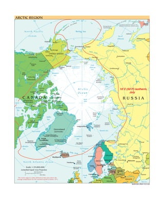
1. ARCTIC REGION
150 180 DS 150
AN
IS L
50 N DS R IL
LA KU occupied by the Soviet Union in 1945,
JAPAN
IS
N Petropavlovsk- administered by Russia, claimed by Japan.
A
TI Kamchatskiy
U
LE
North Pacific Bering Sea
A
Sakhalin
Ocean Sea of
Okhotsk Khabarovsk
Amur
Kodiak
Bethel 60
Provideniya Anadyr' Magadan
Gulf of Bering
Alaska Strait
Anchorage a
Nome lym Okhotsk
Valdez Arctic Ko
Circle
Juneau UNITED STATES
Fairbanks er
Chukchi Oymyakon
Riv
Aldan CHINA
Whitehorse Sea Cherskiy
Pevek
on
Yuk
Dawson
70 Wrangel
Yakutsk
Watson Island
120 Lake Barrow average minimum
East 120
Prudhoe extent of sea ice Siberian Verkhoyansk
Pea Bay
ce Macken
zie River Sea
Inuvik
R iver
Hay Beaufort
Vi
River na
lyu
Great Bear Le
Sea
y
Lake Len
Echo Bay Tiksi a
Yellowknife NEW
SIBERIAN
Great Slave Banks 80 ISLANDS
Lake Lake Island Laptev
Athabasca Sea
Victoria
Island
Arctic 10˚C (50˚F) isotherm,
Cambridge
Bay Ocean July
QUEEN
CANADA
Kangiqcliniq
ELIZABETH
North
SEVERNAYA
ZEMLYA RUSSIA
Kaujuitoq ISLANDS Pole
(Rankin Inlet) (Resolute)
90 W 90 E
Noril'sk Yenisey
Repulse Bay Ellesmere
Hudson Island
Alert Dikson
Bay Kara
Qaanaaq FRANZ Sea
Baffin (Thule) JOSEF
LAND
Island Baffin
'
Ob
Bay Nord 80
Iqaluit
(Frobisher Bay) NOVAYA
ZEMLYA
Svalbard Ob'
Longyearbyen Irty
(NORWAY) sh
Greenland Barents Sea
Davis Strait (DENMARK) Pechor
a
Kangerlussuaq Bjørnøya 70
(Søndre Strømfjord) Greenland (NORWAY)
Nuuk Sea
(Godthåb) Itseqqortoormiit
da
Paamiut Murmansk
eg
60 (Scoresbysund) 60
ch
(Frederikshåb) Perm'
Vy
Tasiilaq Jan Mayen
(Ammassalik) (NORWAY) Tromsø Arkhangel'sk
ev
Labrador
S
Narsarsuaq e r n aya Dvina
a
Kam
Sea Norwegian
ona
60
Denmark Strait Lake Kazan'
Sukh
Arctic
Sea Onega
Circle Samara
ICELAND FINLAND
Reykjavík NORWAY Lake Nizhniy
Ladoga Novgorod KAZ.
Volga
Helsinki St. Petersburg Moscow Saratov
Faroe SWEDEN
North Atlantic Ocean Tórshavn Islands
(DENMARK) Tallinn EST.
Oslo Stockholm 50
Scale 1:39,000,000 SHETLAND LATVIA Don
Volgograd
ISLANDS Riga
Azimuthal Equal-Area Projection
Vilnius Minsk
0 500 Kilometers Baltic LITH.
Kharkiv
0 500 Miles Copenhagen Sea RUS. BELARUS Rostov
North Dnieper
Sea DENMARK
The Arctic region is often defined as that area where the Belfast Warsaw Kiev
average temperature for the warmest month is below 10ºC. UKRAINE
IRE. U.K. 0 Berlin
30 Dublin POLAND 30 Black Sea
GERMANY
802916AI (R02112) 6-02