This document is a map of Africa showing its countries, major cities, and geographical features. Key details shown on the map include national boundaries, capital cities, major rivers like the Nile, seas/oceans around the continent, and elevation points like mountains. The map uses geographic projections and labeling to depict the locations and relationships between places across the entire African landmass and surrounding waters.
This map shows the countries and major geographical features of Africa. It depicts the continent's northern coastline bordering the Mediterranean Sea and its southern coastline bordering the Atlantic and Indian Oceans. Key cities, rivers, lakes and other landmarks are labeled across Africa's diverse landscape ranging from northern deserts to tropical rainforests in the south.
The document summarizes key information about the Amsterdam area as a location for business and decision makers. It highlights that Amsterdam is strategically positioned at the heart of Europe with excellent air, road, water, rail, and internet connections. The region has a diverse global culture and dynamic economy with 173 nationalities represented among its 20 million residents. It also notes that Amsterdam has a long trading tradition, dating back 700 years, and remains one of Northwest Europe's top five ports today.
DB Schenker's skybridge service provides an integrated ocean and air freight solution that reduces transit times and costs compared to traditional air or ocean freight alone. Skybridge uses container ships to transport cargo from Asia to Dubai, then loads shipments onto aircraft for delivery into major European economic centers, cutting total transit time from Asia to Europe in half compared to ocean freight alone. Key benefits include 50% reductions in transit times and costs versus air freight, environmentally friendly operations with 41% lower CO2 emissions, and flexible solutions tailored to customers' individual needs.
El papel se elabora a partir de fibras vegetales molidas, blanqueadas y secadas que forman una pulpa de celulosa. En la antigüedad se escribía sobre papiro en Egipto y pergamino en Europa. En el 105 d.C., el funcionario chino T'sai Lun fabricó el primer papel a partir de fibras de bambú, morera y otras plantas, dando origen al papel moderno. El proceso básico de fabricación de papel implica trocear la materia prima en agua para formar una suspensión de fibras y
Este documento resume la historia de las artes gráficas desde sus orígenes en el arte gráfico prehistórico hasta la explosión de la imaginación en el siglo XX. Explica que las artes gráficas surgieron cuando el ser humano comenzó a transferir imágenes a otros soportes y describes los primeros sistemas de escritura como los ideogramas y jeroglíficos. También cubre la invención de la imprenta por Gutenberg y el desarrollo posterior de técnicas como la litografía.
Este documento describe la evolución de los primeros sistemas de escritura desde los pictogramas en Mesopotamia hasta el desarrollo del alfabeto. Comenzó con pictogramas en la prehistoria, luego se desarrollaron escrituras logográficas como los jeroglíficos egipcios y el cuneiforme sumerio. Más tarde surgieron las escrituras silábicas como el Lineal B que representaba sílabas. Finalmente, el alfabeto fenicio dio lugar al alfabeto griego donde cada signo representa un
El documento describe los diferentes tipos de papel, incluyendo su procedencia, métodos de fabricación y usos. Explica que el papel se obtiene de bosques naturales, secundarios o plantaciones, y que la pasta puede ser mecánica u obtenida químicamente. También describe los principales tipos como prensa, embalaje, cartulina, así como sus características y usos.
Cia World Factbook Reference Map Middle Eastalanocu
This map shows the Middle East region, including countries such as Turkey, Syria, Iraq, Iran, Saudi Arabia, Yemen, Israel, and others. Key geographical features are labeled, such as the Black Sea, Caspian Sea, Persian Gulf, and Red Sea. Major cities throughout the region are also indicated on the map.
1. The map shows the geographic locations of Oceania, including Australia, New Zealand, Southeast Asia, and the Pacific Islands.
2. Key island nations and territories in the region include Japan, Philippines, Indonesia, East Timor, Papua New Guinea, Solomon Islands, Vanuatu, Fiji, Tonga, Samoa, American Samoa, Cook Islands, French Polynesia, and many others.
3. Major bodies of water include the South China Sea, Philippine Sea, Arafura Sea, Coral Sea, Tasman Sea, and South Pacific Ocean.
1) North America spans the northern portion of the Americas and includes Canada, the United States, Mexico, Central America, and the Caribbean.
2) The continent includes diverse geographic features ranging from Arctic tundra in the north to tropical rainforests in Central America and the Caribbean.
3) Major population centers are concentrated along the Canada-US border, around the Great Lakes, in Mexico, and in Central America.
This map provides an overview of Central America and the Caribbean region. It shows the location of countries such as Mexico, Belize, Guatemala, El Salvador, Honduras, Nicaragua, Costa Rica, Panama, Colombia, Venezuela, Guyana, Suriname, French Guiana, and islands such as Cuba, Jamaica, Hispaniola, Puerto Rico, the Lesser Antilles, and The Bahamas. Key cities, physical features such as mountain ranges, oceans, gulfs and bays are also indicated on the map.
The document is a map of South America that shows the countries, major cities, rivers, and seas. It displays political boundaries and labels for countries like Colombia, Venezuela, Guyana, Suriname, French Guiana, Brazil, Ecuador, Peru, Bolivia, Paraguay, Uruguay, Argentina, and Chile. Major geographical features like the Andes Mountains, Amazon River, and Orinoco River are indicated. Major cities shown include Bogotá, Medellín, Caracas, Georgetown, Manaus, Belém, and São Paulo.
1. The document is a map of the Middle East region showing the countries of the Middle East and surrounding areas.
2. Major physical features like the Black Sea, Caspian Sea, Persian Gulf, and Red Sea are labeled on the map.
3. Capital cities, major cities, and other important places are noted with labels on the map.
1) The document is a map of Europe showing the countries, cities, seas, and other geographical features.
2) Major countries shown include Norway, Sweden, Finland, Russia, Germany, France, United Kingdom, Italy, Spain, and others.
3) Physical features like the North Sea, Baltic Sea, Mediterranean Sea, and various rivers and mountain ranges are labeled on the map.
This map shows the geographic and political features of Asia, including countries, cities, seas, oceans, and other landmarks. Major cities are labeled and country borders are delineated. Topographic information such as mountain ranges and elevation points are indicated. The map uses an azimuthal equal-area projection to accurately represent the size and shape of land areas.
The document is a map of the Arctic region showing geographic and political features. It depicts the Arctic Circle, seas, islands, and countries that border or have territory within the Arctic, including the United States, Canada, Russia, Norway, and Alaska. The map notes that the Russian island of Sakhalin was occupied by the Soviet Union in 1945 and is now administered by Russia but claimed by Japan.
The document is a map of the Arctic region highlighting geographic locations. It shows the Arctic Circle and areas north of it occupied or administered by different countries including Russia, the United States, and Canada. The Arctic Ocean is indicated along with surrounding seas like the Bering Sea and bodies of water covered by sea ice on average. Key cities and towns in the Arctic are labeled on the map.
The document is a map of Antarctica showing territorial claims by different countries in the region. It shows research stations operated by various nations around the continent. Several countries including Argentina, Chile, the UK, and others have made claims to portions of Antarctic territory, though not all claims are internationally recognized.
Philippine Edukasyong Pantahanan at Pangkabuhayan (EPP) CurriculumMJDuyan
(𝐓𝐋𝐄 𝟏𝟎𝟎) (𝐋𝐞𝐬𝐬𝐨𝐧 𝟏)-𝐏𝐫𝐞𝐥𝐢𝐦𝐬
𝐃𝐢𝐬𝐜𝐮𝐬𝐬 𝐭𝐡𝐞 𝐄𝐏𝐏 𝐂𝐮𝐫𝐫𝐢𝐜𝐮𝐥𝐮𝐦 𝐢𝐧 𝐭𝐡𝐞 𝐏𝐡𝐢𝐥𝐢𝐩𝐩𝐢𝐧𝐞𝐬:
- Understand the goals and objectives of the Edukasyong Pantahanan at Pangkabuhayan (EPP) curriculum, recognizing its importance in fostering practical life skills and values among students. Students will also be able to identify the key components and subjects covered, such as agriculture, home economics, industrial arts, and information and communication technology.
𝐄𝐱𝐩𝐥𝐚𝐢𝐧 𝐭𝐡𝐞 𝐍𝐚𝐭𝐮𝐫𝐞 𝐚𝐧𝐝 𝐒𝐜𝐨𝐩𝐞 𝐨𝐟 𝐚𝐧 𝐄𝐧𝐭𝐫𝐞𝐩𝐫𝐞𝐧𝐞𝐮𝐫:
-Define entrepreneurship, distinguishing it from general business activities by emphasizing its focus on innovation, risk-taking, and value creation. Students will describe the characteristics and traits of successful entrepreneurs, including their roles and responsibilities, and discuss the broader economic and social impacts of entrepreneurial activities on both local and global scales.
Walmart Business+ and Spark Good for Nonprofits.pdfTechSoup
"Learn about all the ways Walmart supports nonprofit organizations.
You will hear from Liz Willett, the Head of Nonprofits, and hear about what Walmart is doing to help nonprofits, including Walmart Business and Spark Good. Walmart Business+ is a new offer for nonprofits that offers discounts and also streamlines nonprofits order and expense tracking, saving time and money.
The webinar may also give some examples on how nonprofits can best leverage Walmart Business+.
The event will cover the following::
Walmart Business + (https://business.walmart.com/plus) is a new shopping experience for nonprofits, schools, and local business customers that connects an exclusive online shopping experience to stores. Benefits include free delivery and shipping, a 'Spend Analytics” feature, special discounts, deals and tax-exempt shopping.
Special TechSoup offer for a free 180 days membership, and up to $150 in discounts on eligible orders.
Spark Good (walmart.com/sparkgood) is a charitable platform that enables nonprofits to receive donations directly from customers and associates.
Answers about how you can do more with Walmart!"
Chapter wise All Notes of First year Basic Civil Engineering.pptxDenish Jangid
Chapter wise All Notes of First year Basic Civil Engineering
Syllabus
Chapter-1
Introduction to objective, scope and outcome the subject
Chapter 2
Introduction: Scope and Specialization of Civil Engineering, Role of civil Engineer in Society, Impact of infrastructural development on economy of country.
Chapter 3
Surveying: Object Principles & Types of Surveying; Site Plans, Plans & Maps; Scales & Unit of different Measurements.
Linear Measurements: Instruments used. Linear Measurement by Tape, Ranging out Survey Lines and overcoming Obstructions; Measurements on sloping ground; Tape corrections, conventional symbols. Angular Measurements: Instruments used; Introduction to Compass Surveying, Bearings and Longitude & Latitude of a Line, Introduction to total station.
Levelling: Instrument used Object of levelling, Methods of levelling in brief, and Contour maps.
Chapter 4
Buildings: Selection of site for Buildings, Layout of Building Plan, Types of buildings, Plinth area, carpet area, floor space index, Introduction to building byelaws, concept of sun light & ventilation. Components of Buildings & their functions, Basic concept of R.C.C., Introduction to types of foundation
Chapter 5
Transportation: Introduction to Transportation Engineering; Traffic and Road Safety: Types and Characteristics of Various Modes of Transportation; Various Road Traffic Signs, Causes of Accidents and Road Safety Measures.
Chapter 6
Environmental Engineering: Environmental Pollution, Environmental Acts and Regulations, Functional Concepts of Ecology, Basics of Species, Biodiversity, Ecosystem, Hydrological Cycle; Chemical Cycles: Carbon, Nitrogen & Phosphorus; Energy Flow in Ecosystems.
Water Pollution: Water Quality standards, Introduction to Treatment & Disposal of Waste Water. Reuse and Saving of Water, Rain Water Harvesting. Solid Waste Management: Classification of Solid Waste, Collection, Transportation and Disposal of Solid. Recycling of Solid Waste: Energy Recovery, Sanitary Landfill, On-Site Sanitation. Air & Noise Pollution: Primary and Secondary air pollutants, Harmful effects of Air Pollution, Control of Air Pollution. . Noise Pollution Harmful Effects of noise pollution, control of noise pollution, Global warming & Climate Change, Ozone depletion, Greenhouse effect
Text Books:
1. Palancharmy, Basic Civil Engineering, McGraw Hill publishers.
2. Satheesh Gopi, Basic Civil Engineering, Pearson Publishers.
3. Ketki Rangwala Dalal, Essentials of Civil Engineering, Charotar Publishing House.
4. BCP, Surveying volume 1
How to Setup Warehouse & Location in Odoo 17 InventoryCeline George
In this slide, we'll explore how to set up warehouses and locations in Odoo 17 Inventory. This will help us manage our stock effectively, track inventory levels, and streamline warehouse operations.
Beyond Degrees - Empowering the Workforce in the Context of Skills-First.pptxEduSkills OECD
Iván Bornacelly, Policy Analyst at the OECD Centre for Skills, OECD, presents at the webinar 'Tackling job market gaps with a skills-first approach' on 12 June 2024
Main Java[All of the Base Concepts}.docxadhitya5119
This is part 1 of my Java Learning Journey. This Contains Custom methods, classes, constructors, packages, multithreading , try- catch block, finally block and more.
LAND USE LAND COVER AND NDVI OF MIRZAPUR DISTRICT, UPRAHUL
This Dissertation explores the particular circumstances of Mirzapur, a region located in the
core of India. Mirzapur, with its varied terrains and abundant biodiversity, offers an optimal
environment for investigating the changes in vegetation cover dynamics. Our study utilizes
advanced technologies such as GIS (Geographic Information Systems) and Remote sensing to
analyze the transformations that have taken place over the course of a decade.
The complex relationship between human activities and the environment has been the focus
of extensive research and worry. As the global community grapples with swift urbanization,
population expansion, and economic progress, the effects on natural ecosystems are becoming
more evident. A crucial element of this impact is the alteration of vegetation cover, which plays a
significant role in maintaining the ecological equilibrium of our planet.Land serves as the foundation for all human activities and provides the necessary materials for
these activities. As the most crucial natural resource, its utilization by humans results in different
'Land uses,' which are determined by both human activities and the physical characteristics of the
land.
The utilization of land is impacted by human needs and environmental factors. In countries
like India, rapid population growth and the emphasis on extensive resource exploitation can lead
to significant land degradation, adversely affecting the region's land cover.
Therefore, human intervention has significantly influenced land use patterns over many
centuries, evolving its structure over time and space. In the present era, these changes have
accelerated due to factors such as agriculture and urbanization. Information regarding land use and
cover is essential for various planning and management tasks related to the Earth's surface,
providing crucial environmental data for scientific, resource management, policy purposes, and
diverse human activities.
Accurate understanding of land use and cover is imperative for the development planning
of any area. Consequently, a wide range of professionals, including earth system scientists, land
and water managers, and urban planners, are interested in obtaining data on land use and cover
changes, conversion trends, and other related patterns. The spatial dimensions of land use and
cover support policymakers and scientists in making well-informed decisions, as alterations in
these patterns indicate shifts in economic and social conditions. Monitoring such changes with the
help of Advanced technologies like Remote Sensing and Geographic Information Systems is
crucial for coordinated efforts across different administrative levels. Advanced technologies like
Remote Sensing and Geographic Information Systems
9
Changes in vegetation cover refer to variations in the distribution, composition, and overall
structure of plant communities across different temporal and spatial scales. These changes can
occur natural.
LAND USE LAND COVER AND NDVI OF MIRZAPUR DISTRICT, UP
World Map - Africa
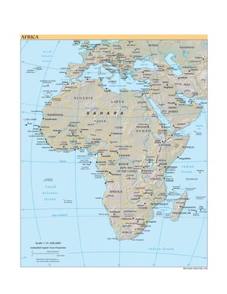
1. AFRICA
40 20 Dublin 0 20 Minsk 40 60
IRE. U.K.
Amsterdam Berlin
London NETH.
Warsaw BELARUS RUSSIA
POLAND
KAZAKHSTAN
Brussels GERMANY Kiev
North BEL. LUX. Prague
CZ. REP. UKRAINE Volg Aral
Sea
SLOV. a
Paris Bratislava Rostov
Atlantic SWITZ. Bern
Vienna
AUS. Budapest
MOL. Chisinau
Tashkent
HUNG. Sea of
FRANCE SLO. ROM. Odesa Azov
Ljubljana
40
Ocean Milan Zagreb
CRO. Belgrade Bucharest UZBEKISTAN
Marseilles BOS. & Danube
HER. Black Sea GEO. Caspian
AND. ITALY Sarajevo SER.& Sofia
MONT. Tbilisi Sea
Ponta Barcelona Corsica
BULG. TURKMENISTAN
Delgada PORTUGAL Rome Tirana Skopje Istanbul ARM. AZER. Baku
AZORES Madrid Ashgabat
MACE. Ankara Yerevan
(PORTUGAL) Lisbon Naples ALB.
SPAIN Sardinia GREECE . Mashhad
Izmir TURKEY -
Tabriz
Algiers Tunis Sicily Athens
Adana Tehran
Strait of Gibraltar Oran Aleppo AFG.
MADEIRA ISLANDS Constantine Valletta Nicosia
(PORTUGAL) Rabat SYRIA IRAQ
Fès MALTA
CYPRUS LEB. -
Esfahan
¸
Casablanca
Funchal TUNISIA Mediterranean Sea Beirut
Damascus IRAN
MOROCCO Baghdad
Jerusalem
Marrakech - - Alexandria ISRAEL Amman -
Shiraz
CANARY ISLANDS Tripoli Banghazi
(SPAIN) Cairo JORDAN Kuwait Bandar
-
KUWAIT 'Abbas
-
Al Jizah Persian
Las Palmas
Laayoune ALGERIA Manama Gulf
Nile
(El Aaiún) Abu
BAHR.
Western LIBYA EGYPT Riyadh Doha Dhabi
Muscat
Sahara Medina QATAR
- U.A.E
Al Jawf Aswan
Tropic of Cancer Admin.
SAUDI OMAN
boundary
Nouadhibou Jiddah ARABIA
20 20
MAURITANIA S A H A R A Port Red
Mecca
Sudan
Sea
CAPE VERDE Nouakchott
le
Ni
Tombouctou NIGER
Praia Agadez Omdurman ERITREA YEMEN
Dakar MALI Khartoum Asmara
Arabian
SENEGAL CHAD Sanaa
Banjul Nig
er
Niamey Zinder
Sea
Bamako BURKINA Lac'Assal
THE GAMBIA FASO SUDAN (lowest point in
Gulf of
Socotra
Djibouti Aden
Blu
Bissau N'Djamena Africa, -155 m)
e
Kano (YEMEN)
Nile
GUINEA-BISSAU Ouagadougou DJIBOUTI
GUINEA
Ni
BENIN EY
le
Conakry
ite
NIGERIA L Hargeysa
Wh
Addis
L
Freetown GHANA Abuja Moundou
CÔTE Ababa
A
Vo
Ogbomoso lta TOGO
V
SIERRA LEONE D'IVOIRE ue Prov.
Ibadan Ben CENTRAL AFRICAN
ETHIOPIA Admin.
Monrovia Lomé Lagos Line SOMALIA
FT
Yamoussoukro Accra REPUBLIC
LIBERIA Porto- CAMEROON Juba
Bangui
RI
Abidjan Novo Douala
Malabo
Yaoundé CONGO
AT
EQUATORIAL GUINEA
Congo UGANDA
Gulf of Guinea Mogadishu
GRE
SAO TOME REP. OF Kisangani Kampala KENYA
0 Equator AND PRINCIPE Libreville 0
THE
São Tomé GABON CONGO BASIN Nairobi
Annobón
DEM. REP. Bukavu
RWANDA Kigali
Lake Mt. Kilimanjaro Indian
(EQUA. GUI.) (highest point in
Victoria Africa, 5895 m)
Bujumbura Victoria
Brazzaville
Pointe-Noire
OF THE CONGO
BURUNDI Mombasa Ocean
Kinshasa Kananga Lake Dodoma
ANGOLA Tanganyika Zanzibar
(Cabinda)
Ascension Mbuji-Mayi TANZANIA Dar es SEYCHELLES
(St. Helena) Salaam
Luanda
South Lubumbashi
Lake
Nyasa COMOROS
Moroni Glorioso Islands
MALAWI (FRANCE)
Atlantic ANGOLA Kitwe Lilongwe Cidade
Mayotte
(admin. by France,
de Nacala claimed by Comoros)
Lubango ZAMBIA Tromelin Island
Namibe Blantyre
Ocean St. Helena
Lusaka Juan de Nova Island
(FRANCE)
Mahajanga (FRANCE)
Zambe
(St. Helena) zi Toamasina
Harare
MOZAMBIQUE
NA
Antananarivo Port
ZIMBABWE Beira Mozambique Louis
M
20 20
IB
Channel St. Denis
Windhoek BOTSWANA Bassas MAURITIUS
Walvis Bay KALAHARI
da India
(FRANCE)
Europa MADAGASCAR Reunion
Tropic of Capricorn DESERT
Island (FRANCE)
NAMIBIA (FRANCE)
Gaborone
DES
Pretoria
Maputo
ERT
Johannesburg
Mbabane
SOUTH
O
SWAZILAND
ran Maseru
ge
Durban
AFRICA LESOTHO
Cape Town
Port Elizabeth
Scale 1:51,400,000
Azimuthal Equal-Area Projection Indian Ocean
0 800 Kilometers
0 800 Miles
40 40
Boundary representation is
not necessarily authoritative.
20 0 20 40 60
803103AI (R02109) 3-05