Download to read offline
![1
INTRODUCTION
The rapid rise in the number and severity of devastating natural disasters over the past
two decades have forced local, regional, and national leaders to redraw land use plans and
rethink development patterns and strategies in order to restore and to prepare their
communities physically, economically, and demographically. In the United States, this has been
seen most vividly in places like Greensburg, Kansas, and New Orleans, Louisiana.
Internationally, the 2010 earthquake in Haiti and 2011 tsunami in Japan provide examples on a
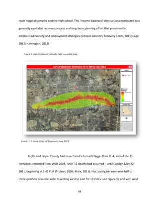
larger national scale. Most recently, the city of Joplin, Missouri, suffered an EF-51
tornado on
May 22, 2011, resulting in 160 deaths and a path of destruction scarring the city for over 22
miles at an average of three-quarter mile wide (Joplin Citizens Advisory Recovery Team, 2011).
Using Joplin as a case study, this paper will discuss various community and economic
development methods, tools, and plans—good and bad—that a city like Joplin can use both to
effectively mitigate future natural disasters, sustainably recover from such a disaster, and build
long-term resilience and adaptability. This paper intends to review hazard mitigation strategies
in general, discuss land use planning options related to natural disaster mitigation, and apply
these findings to the city of Joplin and their most recent violent threat: the tornado.
Natural Disaster Hazard Mitigation
A natural disaster, in the most simple of terms, occurs as a result of “an extreme
geological, meteorological, or hydrological event exceed[ing] the ability of a community to cope
1
Tornadoes are labeled on a scale from EF-0 to EF-5 based on their resultant damage, with EF referring to the
Enhanced Fujita Scale (Carmona, 2010). EF-5 identifies the most severe tornado possible, with a damage
assessment labeled as “Incredible,” 3-second gusts of over 200 miles per hour, “strong frame houses leveled,” and
“automobile-sized missiles fly through the air in excess of 100 meters (109 yards)” (ibid., 88).](https://image.slidesharecdn.com/b4f97534-d190-4fb5-a429-59e2bb6516f0-160707164309/85/Allen_Scott_H_Final_Paper-7-320.jpg)
![11
Sadly, Grazulis (2001) offers two words as reasons for the lack of tornado preparedness
at the local community level: apathy and greed. In his words: “Apathy is a product of the rarity
of tornadoes;” whereas “[g]reed, in the form of shortcuts in construction, can play a part in
building failures” (173). For example, even though a state such as Florida requires “hurricane
clips” (i.e., reinforced bracing connecting roof structures to tilt-up-panel walls), the added cost
to do so in Missouri has not yet outweighed the risk chance for tornadoes, despite the fact that
tornado damage can create more localized devastation than a hurricane. These mentalities
exist in spite of the fact that tornadoes have increased in multitude year-to-year since the
1950’s (see Figure 2). Even though casualties from other natural disasters have trended
downward since that time, deaths from tornadoes have remained constant (Mileti, 2004).
Beyond loss of life, tornadoes and their destructive outcomes lead to “downtime for
businesses, lost employment, environmental damage, [and] emotional effects on victims”](https://image.slidesharecdn.com/b4f97534-d190-4fb5-a429-59e2bb6516f0-160707164309/85/Allen_Scott_H_Final_Paper-17-320.jpg)


![19
including: providing a balanced approach to risk management principles and other land use
planning goals; identifying geographic (spatial) aspects of exposure to natural disaster risks; and
providing considerations of natural disaster risks in locating, designing, and constructing private
and public developments. Srivastava and Laurian (2006) also list several benefits of
comprehensive plans as vehicles for hazard mitigation, noting that they “can steer growth and
development away from hazard-prone areas, restrict land uses in sensitive areas, locate public
infrastructures away from hazard areas, and impose building standards that reduce the
vulnerability of structures” (463).
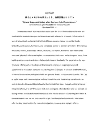
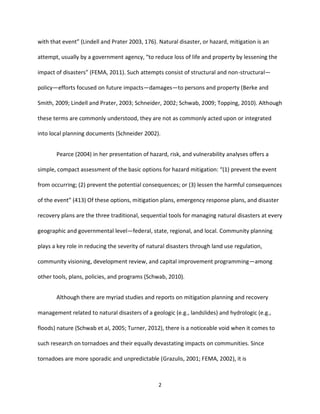
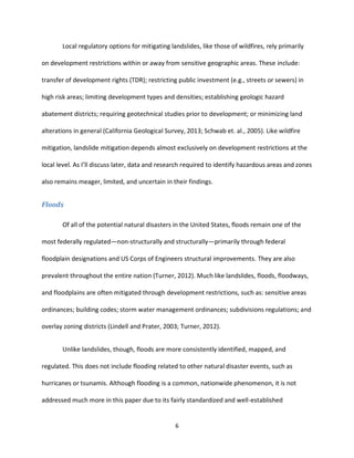
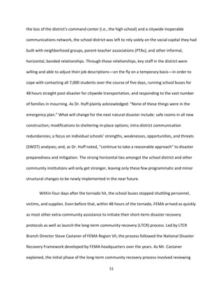
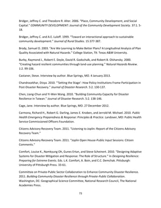
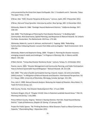
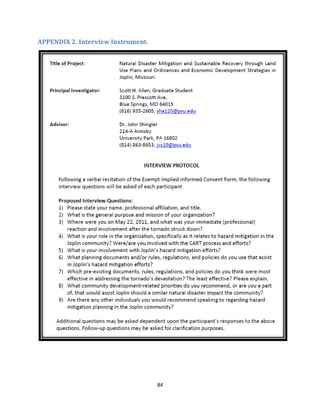
As shown in Table 1, tornadoes are presented with the least options for planning
relevancy within a comprehensive plan. As this and others suggest, tornado areas (a/k/a, alleys)
are so generalized and broad in definition and scope that applying land use planning to them is
“almost meaningless” (Schwab et. al. 1998, 204).
Table 1. Potential Relevance of Disaster Types to Mitigation Provisions in Comprehensive Plan Elements
Type of Plan Element Flood Coastal
Hazards (incl.
tsunami)
Seismic Wildfire Tornado Landslide Volcano
Hazards X X X X X X X
Land Use X X
Conservation X X X X X
Public Facilities X X X X X X X
Transport X X X X X X
Capital
Improvements
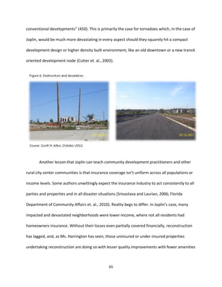
X X X X X X X
Housing X X X X X X
Historic Preservation X X X X X
Economic
Development
X X X X X
Recreation & Open
Space
X X X (near
fault lines)
X X X
Environment X X X X X X
Implementation X X x X X X X
Source: Schwab 2010, 39 [emphasis mine]](https://image.slidesharecdn.com/b4f97534-d190-4fb5-a429-59e2bb6516f0-160707164309/85/Allen_Scott_H_Final_Paper-25-320.jpg)
![23
entities (horizontal) extending to state and federal programs and agencies pre- and post-
disaster (vertical) (Committee on Private-Public Sector Collaboration, 2011). As the Committee
sums up: “Private-public sector collaboration is an essential component of building capacity in
communities” (39).
Safe Growth Audits, Risks/Hazards Analyses/Appraisals, and Other Strategies
Ideally, quantitative models would be able to be applied to all natural disaster hazard
mitigation. However, it currently applies strongest only to geologic hazard assessment, such as
landslides or earthquakes (Schwab et. al., 2005). Historical analysis of natural disasters based
on observational data, combined with a direct cause-and-effect relationship, yields an
“empirical deterministic” quantitative model (ibid., 77). This is more useful for natural disasters
such as landslides that are static (i.e., land-based) and measurable (e.g., slopes and soil types)
than they are for airborne disasters that create varied impact despite their typology (e.g.,
Enhanced Fujita, or EF, scale) such as tornadoes. A more promising quantitative model for
tornadoes relies on greater variability and uncertainty: the “empirical probabilistic” model. This
model uses historical data (i.e., empirical) but “include[s] an uncertainty component to reflect
real world complexity” (ibid., 80). Whereas this model assists planners in determining landslide
likelihood for certain soil and slop conditions, one designed for tornadoes could help improve
predictability of tornado damage based on specific meteorological conditions, such as
atmospheric pressure, temperature, or even topographical conditions such as terrain, presence
and impact of water bodies, tree typology, or simply intensity of vertical development.
Although such quantitative models have only been used for geologic hazard assessment, certain
adjustments could allow a modified version to be applied to tornado hazard mitigation.](https://image.slidesharecdn.com/b4f97534-d190-4fb5-a429-59e2bb6516f0-160707164309/85/Allen_Scott_H_Final_Paper-29-320.jpg)
![24
A new technical and structural effort is also underway through the U.S. Department of
Commerce’s National Institute of Standards and Technology (NIST). Begun in late 2011, NIST
has led a National Windstorm Impact Reduction Program (NWIRP) “to improve model codes,
standards, design guidance, and practices for the construction and retrofit of buildings,
structures, and lifelines” (NIST 2012, 1). Having gathered statistical and historical data on
‘windstorms,’ such as tornadoes and hurricanes, for sixty years, this new federal effort looks to
significantly improve windstorm forecasting and responsiveness. In doing so, data will be
collected on “the performance of the built environment” during such events, emergency
management responsiveness, and the effective value of hazard mitigation plans (ibid., 1). These
efforts hope to yield improved knowledge on mitigation, response, and recovery techniques, as
well as resilience within building code standards, that can be shared and replicated nationwide.
An emerging option for quantifying financial and regulatory impacts of natural disaster
hazard mitigation is the benefit-cost analysis (BCA) (a/k/a, cost-benefit analysis) (Ganderton,
2004; Magsino, 2009). As a definition: “BCA requires a complete enumeration of all
gains/benefits and losses/costs associated with a [hazard mitigation] project, and as such
produces a benchmark for measuring the impact and performance of the project” (Ganderton
2004, 447). Ganderton acknowledges that different individuals and groups within a community
may attribute different values to various hazard mitigation methods and outcomes but still
offers positives and negatives to a BCA approach. The potential benefits of BCA include the
rather obvious: reductions to life, health, and safety losses; business disruptions; and property
damage and destruction. Less direct are Ganderton’s possible costs associated with hazard
mitigation efforts: “lower property values due to new zoning [e.g., floodplains]”; “denial of](https://image.slidesharecdn.com/b4f97534-d190-4fb5-a429-59e2bb6516f0-160707164309/85/Allen_Scott_H_Final_Paper-30-320.jpg)
![30
RESPONSE AND RECOVERY STRATEGIES
Post-disaster recovery planning is an emerging need and new challenge for local
community planners (Blanco & Alberti, 2009; Schwab et al, 1998). Not only has preventive
hazard mitigation planning shown itself to be of critical importance, but the recovery stages,
from immediate to long-term, also present themselves as vital components for a resilient and
sustainable community. Shaffer, et. al. (2004), offer insightful wisdom into the value of both
short-term and long-term community development recovery approaches—one that applies to
all geographic levels:
Often people are more interested in short-term projects than in long-term
strategies. Both are important. The long-term strategies provide people the
overarching direction for the community. The short-term projects provide
tangible feedback that local people need to stick with the long-term strategy.
(211)
Post-Disaster Redevelopment Plans
One of the leaders in disaster planning efforts is the State of Florida. Regionally,
communities are required to develop, adopt, and implement post-disaster recovery plans
(PDRPs). Led by the Florida Department of Community Affairs and the Florida Division of
Emergency Management, PDRPs have been developed at the regional scale but implementable
down to the county level (Florida Department of Community Affairs et. al., 2010).
The State of Florida’s PDRP guidance recommends emphasizing land use considerations
in local and regional PDRPs to the point of saying: “Land use is the most central topic to address
in the [PDRP]” (ibid., 44). Using catch phrases like “flexible strategy” and “increased resiliency,”
Florida’s land use commentary through their PDRP guidance appears thin and non-committal](https://image.slidesharecdn.com/b4f97534-d190-4fb5-a429-59e2bb6516f0-160707164309/85/Allen_Scott_H_Final_Paper-36-320.jpg)
![35
Turner, 2012). Overlay districts allow planners, through collaboration in a community
participation process, to establish an area with new design standards, housing options, specific
construction techniques, and other redevelopment goals to impart a new development concept
and vision rather than simply a reconstruction of the same pre-disaster aesthetic. Overlay
districts have been successfully implemented in several, primarily Western U.S., communities:
Landslide Hazard Areas in Portland, Oregon (2002); Flood Hazard Overlay District in Prince
William County, Virginia (1995); and an all-hazards approach with multiple Natural Hazards
Overlay Districts in Weber County, Utah (2009), which also offers the droll but truthful
comment that “[t]he use of hazardous sites for open space is encouraged” (38-6).
Located along the Front Range of the Rocky Mountains, Douglas County, Colorado,
offers a substantive example of overlay district regulations, with the adoption of a Wildfire
Hazard Overlay District in 1999 and updates to this and related wildfire regulations in 2007
(Successful Communities Online Toolkit, 2012). Visited by frequent cycles of wildfires, Douglas
County planners used this documented history to open a dialogue with the fire departments
and districts within Douglas County, as well as the State Forest Service and the public (ibid.).
Through this discussion and debate, Douglas County developed a multi-classification system to
delineate and map the most wildfire susceptible areas—leading to the Wildfire Hazard Overlay
District designations requiring added fire protection measures and building safety
enhancements to minimize wildfire risk and improve wildfire resilience.
In response to a specific disaster, Jefferson County, Colorado, updated and improved
their Geologic Hazard Overlay District regulations in 2001 and 2010 (Jefferson County, 2010).](https://image.slidesharecdn.com/b4f97534-d190-4fb5-a429-59e2bb6516f0-160707164309/85/Allen_Scott_H_Final_Paper-41-320.jpg)
![38
Federal grant funds are clear choices for financing community-wide and individual
recovery and reconstruction efforts. Community Development Block Grant (CDBG), Small
Business Administration (SBA), and Hazard Mitigation Grant Program (HMGP) funds can all be
targeted towards natural disaster recovery (Schwab et. al., 1998; Muller and Schulte, 2011;
Laska et. al., 2010). Relocation assistance may also be available through various sources,
including FEMA or state offices. Regardless, it is important to understand the somewhat grim
local and regional economic reality presented by Laska, et. al. (2010): “Structures other than
private homes are more important to the [economic] functioning of a community as a whole
than are the homes” (6). In terms of employment, tax base, and goods and services distribution,
this is difficult to argue even in spite of being faced with a rash of homeless families, even in a
temporary fashion.
Yet it is important to make the point here that development in the community alone
cannot reinvigorate and sustain a community. Development of the community must be
undertaken in conjunction with Laska’s development in the community elements of economic
growth, employment creation, and services modernization (Summers, 1986). As Sen (1999)
succinctly stresses: “Development has to be more concerned with enhancing the lives we lead
and the freedoms we enjoy” (14).
Throughout the 1990’s and into this century, specialized regulatory districts have
evolved to address various economic development concerns. Regionally, economic
development districts have come into being to provide technical assistance to local
communities looking to improve their economic resilience in the face of natural disasters](https://image.slidesharecdn.com/b4f97534-d190-4fb5-a429-59e2bb6516f0-160707164309/85/Allen_Scott_H_Final_Paper-44-320.jpg)

![45
management [or mitigation] system to respond to feedbacks from the environment” (Berkes
and Folke 1998, 10). However, it also looks to more efficiently maintain those parts of the
community already committed to the urban pattern and to promote those areas that embody a
sense of community pride (Beatley, 1995). Those areas or community components or factors
exist within one or more of the Three E’s.
Mirroring the community response to the environment discussed by Berkes and Folke
(1998) above, human feedbacks to the environment also provide critical context to the current
and future state of natural disaster hazard mitigation. This is discussed through the theory of
global warming, or climate change. Numerous authors of natural disaster research more and
more routinely point to climate change as an essential variable in the dialogue on natural
disaster mitigation and recovery. The consistent prognostication is that human impacts on the
natural environment are exacerbating climate change (a/k/a global warming), thereby annually
increasing the number, frequency, and severity of natural disasters—tornadoes in particular
(Grazulis, 2001; Mileti and Gailus, 2004; Newton et. al., 2004; McBean, 2004; Pine, 2009;
Concannon, 2000; Sánchez Rodríguez, 2009). This knowledge can be used by local leaders to
further amplify the value and importance of natural disaster hazard mitigation and construct
new and improved responses to the globally important climate change quandary (Sánchez
Rodríguez, 2009). Although the literature rarely offers practical climate change solutions to
incorporate into mitigation or recovery plans, a multitude of carbon-reducing actions not only
lead to a ‘greener’ community overall but now can be attributed to lessening the rate of
increase in natural disaster severity and magnitude.](https://image.slidesharecdn.com/b4f97534-d190-4fb5-a429-59e2bb6516f0-160707164309/85/Allen_Scott_H_Final_Paper-51-320.jpg)

![50
Providentially, the Joplin and Jasper County emergency management personnel had just
completed a two-day, full-scale emergency response exercise with a New Madrid fault
earthquake scenario just four days before the tornado struck. In joint operations with the Joplin
Emergency Management office is the Jasper and Newton Counties Public Health Emergency
Plan, headed by the Emergency Response Planner, Lawrence “Mac” McKeough. In addition to
engagement of local and regional capacities, the joint operations were able to quickly mobilize
a state-level response, with a federal (FEMA) response on-site within 48 hours. This was in part
a result of many years of regular dialogue with the local hospitals and other emergency
management partners. As Mr. McKeough explained: “Starting about [twelve years ago] we
started meeting with the hospitals, making sure everyone’s on the same page, getting all of the
players to the table.” Without previously existing, mature, and comprehensive mutual
agreements at the regional level, medical and infrastructure assistance would have been greatly
delayed, sporadic, and incomplete.
Faced with such a massive task of finding people and belongings, securing properties
and structures, and initiating such a large scale cleanup, Joplin residents, leaders, and
institutions called upon their long-standing and long-growing personal and professional
relationships (i.e., social capital). Just a few hours after Joplin High School graduation
ceremonies, Superintendent C.J. Huff, was forced to rely on the relationships he had built over
the past five years with the Joplin School District. According to Dr. Huff, the school district’s
emergency management plan seemed too anemic to help with this scope of disaster and “had
to ‘rewrite’ it as [they] went along.” Dr. Huff, the district’s 1,100 staff, and 7,000 students were
best prepared for small events and ones that occurred during the school day. Combined with](https://image.slidesharecdn.com/b4f97534-d190-4fb5-a429-59e2bb6516f0-160707164309/85/Allen_Scott_H_Final_Paper-56-320.jpg)
![52
community plans and socio-demographic information. Some of the highest value is placed on
community capacity, including connections with regional institutions, the quality and level of
public engagement in the local comprehensive planning process, and, as Mr. Castaner identified
it, the existence of “very capable existing leadership” and informal leadership. Yet, local plans
may be non-specific or outdated. As Mr. Castaner explained: “Hazard mitigation plans
stereotypically don’t have a lot of public engagement…and so they have some limitations; they
tend to be similar [to each other].” Educating the local leaders—formal and informal—through
FEMA’s Long-Term Community Recovery: A Self-Help Guide, FEMA provided technical assistance
and objectivity in the initial recovery planning stages: anecdotes and lessons learned; how to
plan a series of public meetings; and organizing a meeting between Joplin and Greensburg,
Kansas. All of these elements led to the quick formation and launch of a multi-discipline, multi-
jurisdictional, comprehensive community engagement working group and process. Some have
called such a group a “Disaster Recovery Task Force” (Berke and Wegner 1991, 38), but Joplin
called theirs: CART.
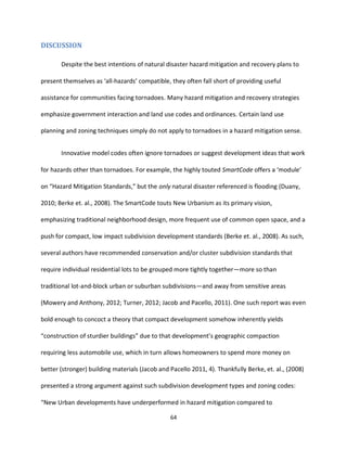
One of the most unique and powerful outcomes of the tornado recovery process was
the Joplin Citizens Advisory Recovery Team (CART). Formed just 5 weeks after the tornado,
with the first public meeting just two weeks later, the CART, led by local business owner Jane
Cage, consisted of members from various disciplines and institutions to make up four topical
sectors: Housing and Neighborhoods; Schools and Community Facilities; Infrastructure and
Environment; and Economic Development (CART, 2011). Two public meetings were held—July
and August—with respected community leaders—formal and informal—overseeing each
sector.](https://image.slidesharecdn.com/b4f97534-d190-4fb5-a429-59e2bb6516f0-160707164309/85/Allen_Scott_H_Final_Paper-58-320.jpg)
![53
The group reviewing the future vision of subdivision redevelopment and residential
growth was the Housing and Neighborhoods sector, led by Crystal Harrington, Executive Officer
of the Home Builders Association (HBA) of Southwest Missouri. As the regional HBA, one of the
immediate responses to the tornado’s havoc was to broadcast public service announcements
(PSAs) urging affected residents to buy local and checking backgrounds of out-of-town
contractors. According to Ms. Harrington’s data, 500 out-of-town contractors arrived in Joplin
during the weeks immediately following the tornado, with only 29 local HBA members
remaining in the area who were functioning and capable of helping with the demolition and
first rebuilding phases. Thus, the CART group and process were not without their hurdles. After
Hurricane Katrina, the reputation of FEMA as an equitable and responsive government agency
was tarnished nationally through various media accounts (Walters, 2010; Moynihan, 2009).
Starting from this rather negative perception, FEMA, which was noted here as one of the
catalysts for the CART process, was seen at times by the local building community and leaders
within the construction industry, in Ms. Harrington’s estimation, as more of an intrusive, top-
down force rather than the advertised community rebuilder and technical adviser. A common
expectation was that Joplin would follow the lead of Greensburg, Kansas, and their
comprehensive commitment to ‘green’ building initiatives. Since Greensburg was essentially an
effort to rebuild an entirely leveled community and Joplin was looking at a large, but deep,
‘scar’ of sorts, an all-inclusive environmentally sustainable building approach was not pursued.
As Ms. Harrington explained: “[The city’s] goal was very much to keep [the construction
industry] on an even keel” and not attempt any drastic shifts in building codes or construction
strategies. Further aggravating the sense of trust and intended impartiality was the fact that](https://image.slidesharecdn.com/b4f97534-d190-4fb5-a429-59e2bb6516f0-160707164309/85/Allen_Scott_H_Final_Paper-59-320.jpg)
![57
options and vision for redevelopment of Joplin’s tornado ravaged scar and looked at trying to
answer the question, as articulated by studio student Chris Fasl in a December 21, 2012,
interview with the author: “How do you carry the momentum [of enthusiasm to rebuild in new
and better ways] past that initial shock [of losing so much to devastation]?” The studio project
was initiated by one of the department’s adjunct professors whose first job in the community
planning field was for the Harry S Truman Coordinating Council—a regional community
development corporation (CDC) serving Joplin and surrounding communities (Fasl, 2012).
Unlike the hordes of planning and design professionals that descended upon New
Orleans following Hurricane Katrina, at the start of the Fall 2011 semester no such outside
urban design response had yet occurred. As one of the students who led the outreach aspect of
the project, Chris Fasl worked with the author during the two-day design charrette wherein
outside professional experts in each the CART’s four sector topics put the CART’s ideas into
drawings and plans. Located 150 miles north of Joplin, the UMKC class role-played as a hazard
mitigation private consulting firm, operating various real-world aspects of what a private firm
would look like in a post-disaster recovery situation (Fasl, 2012). Like Godschalk’s strategy for
conducting a safe growth audit (Godschalk, 2009), the class reviewed, analyzed, and mapped
existing plans and conditions and asked questions about possible redevelopment scenarios.
An overarching disaster recovery theme certainly accelerated the maturation of their
design concepts and the stunted the grafting of their work into the final redevelopment plans
and reports: “When it comes to tornado recovery, it’s…get it fixed as quickly as possible” (Fasl,
2012). In doing so, and as an artifact of the studio’s design and social science emphasis, only](https://image.slidesharecdn.com/b4f97534-d190-4fb5-a429-59e2bb6516f0-160707164309/85/Allen_Scott_H_Final_Paper-63-320.jpg)
![60
direction from local leaders in the housing and social services institutions in and around Joplin.
They considered the current temporary displacement of several neighborhoods and residents,
the pre-existing condition of high rates of rental and multi-family properties in the affected
area, and the need for an emphasis on sustainable development (CART, 2011). One particular
social structure the Sector evaluated was how the “[s]trict segregation of land uses kept
neighborhoods too homogeneous” (ibid., 7). The Sector concluded that this led to an over-
agglomeration, or clustering, of lower-income housing and higher-density rental property. Their
recommendation was to take this opportunity of a proverbial clean slate to consider zoning and
design techniques that could encourage or require mixed-income neighborhoods and a wider
variety of multi-family options. Although this would not necessarily make these areas any more
structurally or physically resilient in a natural disaster hazard mitigation sense, it would disperse
and mix multiple income levels throughout the damaged area so that a single social group
would not be so wholly devastated should such a catastrophe occur again. This is not so much a
promotion of a shared pain philosophy whereby all income levels would be more equally
damaged as much as it is an attempt to encourage strong horizontal ties amongst the
previously detached income groups in hopes of becoming more socially resilient as a result of a
new strategy for the built environment. In order to implement this approach, the Sector
recommended simple projects such as enhanced, strengthened, and consistent property
maintenance code enforcement in order to maintain property values in the proposed mixed-
income neighborhoods. They also promoted more progressive on-the-ground projects like a
pilot neighborhood that, in effect, embraced the sustainable triumvirate of social equity (e.g.,](https://image.slidesharecdn.com/b4f97534-d190-4fb5-a429-59e2bb6516f0-160707164309/85/Allen_Scott_H_Final_Paper-66-320.jpg)
![66
and smaller square footages. With an equal sense of surprise, Ms. Harrington noted that “[the
tornado] has not changed the way we build houses [in Joplin].”
Not only has lack of adequate insurance coverage affected the poorer impacted areas,
the housing stock typically is originally of lower quality to begin with and therefore initially
more susceptible to damage and loss as a result of even less devastating winds and other
natural disasters (Mileti and Gailus, 2004). Exacerbating this condition is the financial
competition between local builders and low-income assistance groups like Habitat for
Humanity and Samaritan’s Purse. Although local builders were finding a modicum of success in
the rebuilding efforts, they were only able to construct approximately one house for every two
built by non-profit assistance groups (Harrington, 2012).
Experts abound, preaching the pitfalls of poor hazard mitigation planning. They offer
lists of ‘avoidances’ that Joplin and others would be well-advised to consider. Thankfully in
Joplin’s case only a very few minor stumbling blocks were evident in their response and
recovery efforts related to the May 2011 tornado. Pine (2009) lists difficulties problem solving
in an “ill-structured environment” as well as “decision traps” (46-47). Again, Joplin has
successfully avoided all eight listed problem areas, for the most part. A criterion of an ill-
structured environment in Joplin “is a lack of complete information associated with hazards”
(ibid., 46). This is and will be true for any community faced with the continued likelihood of
tornadoes. As it has already been explained, floods, earthquakes, landslides and similar ‘land-
based’ natural disaster hazards are much more quantifiable, observable, and avoidable than
unpredictable tornadoes. However, as noted earlier regarding the NIST’s NWIRP, more and](https://image.slidesharecdn.com/b4f97534-d190-4fb5-a429-59e2bb6516f0-160707164309/85/Allen_Scott_H_Final_Paper-72-320.jpg)
![67
more knowledge—both current and historical—is being gathered for tornadoes, making this
one obstacle much less problematic. A more complete and relevant list of avoidances at the
response and initial recovery stage is offered by Boin (2010): clinging to the plan; waiting for all
facts and figures before making critical decisions; getting fixated on restoring communication
means; acting as if the command-and-control structure still stands; waiting for outside help;
disseminating unverified rumors; initiating the ‘blame game’; berating the public; and treating
the media as an enemy (134-136) [emphasis mine]. These are all certainly fair assessments of
what would constitute a poorly handled natural disaster response. However, Joplin was right to
focus on restoring immediate communication needs in order to more efficiently deploy and
manage first responders and ensure residents were all accounted for, especially the
approximately 7,000 school children (Huff, 2012). Also in Joplin’s case, the command-and-
control structure was still standing and was valuable in coordinating every facet of the
immediate life, health, and safety response (Stammer and McKeough, 2012). Perhaps other
parts of the country or other natural disaster types or scales would pose greater impacts on
these elements, but that was clearly not the case in Joplin.
One element that was overwhelmed, however, was Joplin’s communication system.
Thankfully the 200,000 dollars just previously spent to upgrade emergency warning sirens paid
off in ten minutes of warning for people in the path of the tornado (Stammer and McKeough,
2012). However, the new reverse-911 telephone system was immediately overloaded, with a
three hour delay in pushing out communication to residents (ibid.). The delay was greater in the
tornado’s wake, as several telecommunication towers were knocked out, along with electricity.
Severely taxed communication networks limited emergency response coordination and](https://image.slidesharecdn.com/b4f97534-d190-4fb5-a429-59e2bb6516f0-160707164309/85/Allen_Scott_H_Final_Paper-73-320.jpg)

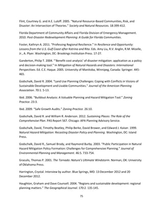

![83
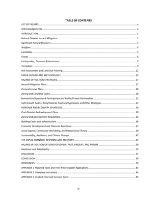
APPENDIX 1. Planning Tools and Their Post-Disaster Applications.
Source: Schwab, et. al., 1998, 117 [emphasis mine]](https://image.slidesharecdn.com/b4f97534-d190-4fb5-a429-59e2bb6516f0-160707164309/85/Allen_Scott_H_Final_Paper-89-320.jpg)

This document is a professional paper submitted in partial fulfillment of a Master's degree in community and economic development. It examines natural disaster hazard mitigation and recovery strategies, using the 2011 EF-5 tornado in Joplin, Missouri as a case study. The paper reviews various hazard mitigation and land use planning tools, discusses response and recovery strategies used in Joplin, and considers additional options to build resilience against future disasters. Key findings are that standard land use controls are limited in mitigating non-land based disasters like tornadoes, and that social capital and community interaction offer better opportunities to improve mitigation, response, and recovery efforts.


