PATH (Partnership for Advancing Technology in Housing) is a public-private partnership managed by HUD that aims to improve the quality, durability, environmental efficiency, and affordability of future homes. The report discusses low impact development (LID) as an approach to site planning and design that manages stormwater runoff and wastewater on-site. LID utilizes practices like infiltration trenches and rain gardens to mimic natural hydrologic functions. It also explores alternatives to conventional wastewater systems like sand filters and mounds that can treat wastewater on-site. The report provides guidance to help communities and developers successfully plan and implement LID practices.
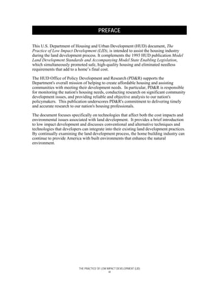


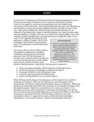


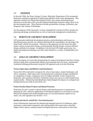
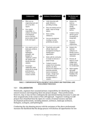
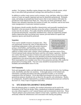


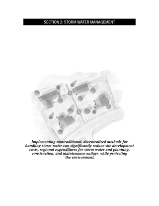

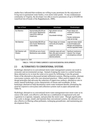
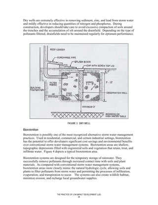
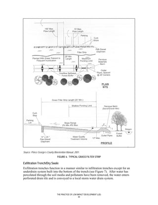
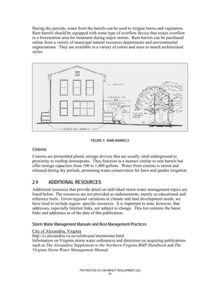
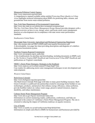


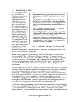
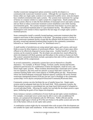
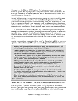
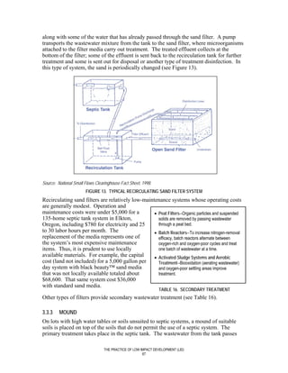
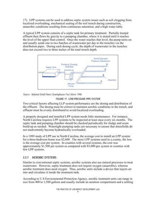

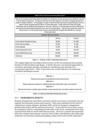
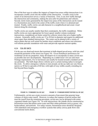

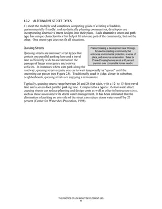
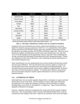
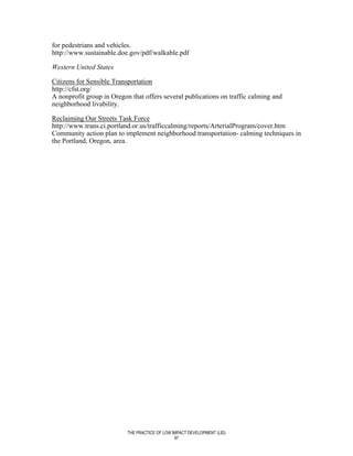


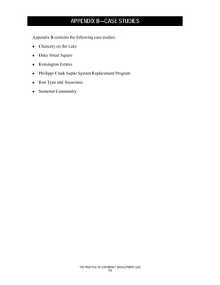
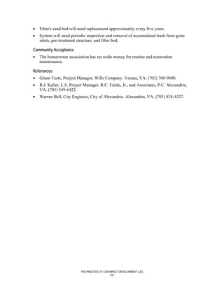
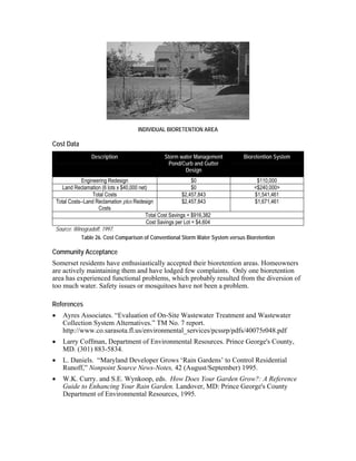
![PHILLIPPI CREEK SEPTIC SYSTEM REPLACEMENT PROGRAM
In Sarasota, Florida, available and applicable on-site wastewater treatment and collection
technologies were evaluated (see Figure 25) to determine their potential for improving
current wastewater treatment and disposal practices in Phillippi Creek.
Specifics
• Available technologies were grouped into three major categories for evaluation:
natural systems (e.g., conventional septic tank and subsurface wastewater infiltration
systems [SWIS] and septic tank and subsurface drip irrigation [SDI] systems);
engineered biological systems (e.g., suspended growth systems, submerged biofilters,
and unsaturated biofilters); and waste segregation systems (e.g., nonwater carriage
toilets and on-site greywater treatment systems).
• Based on the number of connections, total flow, and available treatment plant and
transmission capacities, the project area was previously divided into sixteen (16)
manageable areas referred to as Wastewater Project Improvement Areas (WPIA).
• The cost analysis addressed natural systems and engineered biological systems but,
because of a variety of implementation problems, including community acceptance,
did not address waste segregation systems.
FIGURE 25. EVALUATION PROCESS FOR COMPARING COLLECTION AND ON-SITE WASTEWATER
TREATMENT SYSTEM ALTERNATIVES
Cost Data
• The capital cost of a septic tank with a mound with 12-inch fill was $6,000.
• The capital cost of a septic tank with subsurface drip irrigation with 12-inch fill was
$7,900.
• In terms of uniform annual cost, the septic tank with SWIS mound was the most cost-
effective alternative in a low-density area. In medium- and high- density areas, the
vacuum sewer system was the most cost-effective alternative.
THE PRACTICE OF LOW IMPACT DEVELOPMENT (LID)
109](https://image.slidesharecdn.com/thepracticeoflowimpactdevelopment-path-110507123329-phpapp01/85/The-Practice-of-Low-Impact-Development-PATH-121-320.jpg)
![Maryland Department of the Environment, 2000 Maryland Storm Water Design Manual-
-Volume I--Storm Water Management Criteria, Maryland Department of the
Environment, 2000.
Maryland National Capital Builders Industry Association (MNCBIA), unpublished
research, 2001.
National Association of County Engineers and U.S. Department of Transportation,
Training Guide Series and Action Guide Series [CD-Rom], National Association of
County Engineers and U.S. Department of Transportation, 1997.
National Association of Home Builders, 56th Annual Builders’ Show--Building inside
Nature’s Envelope [Tapes 1 and 2], Chesapeake Audio/Video Comm., Inc., 2000.
National Association of Home Builders and NAHB Research Center, Building Greener,
Building Better--The Quiet Revolution, National Association of Home Builders and
NAHB Research Center, 2002.
National Association of Home Builders, Erosion and Sediment Control Best Management
Practices (BMPs) Research Report – Second Edition, Prepared for NAHB, Washington,
DC by PBS&J, Beltsville, MD, p. 51, 2002b.
National Fire Protection Association, NFPA 1141: Standard for Fire Protection in
Planned Building Groups, 1998 Edition, National Fire Protection Association, 1998.
National Fire Protection Association, NFPA 299: Standard for Protection of Life and
Property from Wildfire, 1997 Edition, National Fire Protection Association, 1997.
National Institute of Building Sciences, Land-Use Regulations Handbook, National
Institute of Building Sciences, 1990.
National Urban NPS Management Measures Guidance [CD-Rom], U.S. Environmental
Protection Agency, 2002.
New Urban News, New Urbanism and Traditional Neighborhood Development, New
Urban News, 2000.
North Central Texas Council of Governments, Guide to Developing Naturally, North
Central Texas Council of Governments, 2001.
------, The Oakland/Berkeley Hills Fire, National Wildland/Urban Information Fire
Program.
-----, Office of Water, Decentralized Systems Technology Fact Sheet-- Aerobic
Treatment, EPA 832-F-00-031, September 2000b.-----, Office of Water, Guidance
Specifying Management Measures for Sources of Nonpoint Pollution in Coastal Waters,
1993.
------, Office of Water, Post-Construction Storm water Management in New Development
& Redevelopment (Part of the National Menu of Best Management Practices for NPDES
THE PRACTICE OF LOW IMPACT DEVELOPMENT (LID)
115](https://image.slidesharecdn.com/thepracticeoflowimpactdevelopment-path-110507123329-phpapp01/85/The-Practice-of-Low-Impact-Development-PATH-127-320.jpg)
![Storm water Phase II), U.S. Environmental Protection Agency, Office of Water, October
27, 2000.
------, Office of Water, Protecting Natural Wetlands: A Guide to Storm water Best
Management Practices, U.S. Environmental Protection Agency, Office of Water, 1996.
------, Office of Water, Office of Wastewater Management, Response to Congress on Use
of Decentralized Wastewater Treatment Systems, U.S. Environmental Protection Agency,
Office of Water, Office of Wastewater Management, 1997.
----, Office of Wetlands, Oceans and Watersheds, Office of Research and Development,
On-Site Wastewater Treatment Systems Manual [CD-Rom], U.S. Environmental
Protection Agency, Office of Wetlands, Oceans and Watersheds, Office of Research and
Development, 2000.
Petit, Jack, Debra L. Bassert et al., Building Greener Neighborhoods: Trees as Part of
the Plan, 2nd ed., American Forest and Paper Association and Home Builder Press of the
National Association of Home Builders, Washington, DC, 1998.
Prince George’s County Department of Environmental Resources, The Bioretention
Manual, Prince George’s County, Maryland, Department of Environmental Resources,
2001.
------, Residential Drainage: A Homeowner’s Guide to Drainage Problems and
Solutions, Prince George’s County, Maryland, Department of Environmental Resources,
1998.
Rocky Mountain Institute, Green Development: Integrating Ecology and Real Estate,
John Wiley & Sons, Inc., 1998.
Sikora, Jeannie Leggett, Profit from Building Green: Award Winning Tips to Build
Energy Efficient Homes, BuilderBooks of the National Association of Home Builders,
2002.
Site Work & Landscape Cost Data, R.S. Means, 2002.
Small Flows Quarterly, Winter 2002.
------, Storm Water Management for Construction Activities: Developing Pollution
Prevention Plans and Best Management Practices, U.S. Environmental Protection
Agency, 1992.
Storm Water Technology Fact Sheet--Bioretention, U.S. Environmental Protection
Agency, 1999.
Sykes, R.D., Chapter 31 – Site Planning, UMN Press, St. Paul, 1989.
Treadway, Elizabeth and Andrew L. Reese, Financial Strategies for Storm water
Management, Ogden Environmental and Engineering Services, Inc., 2000.
THE PRACTICE OF LOW IMPACT DEVELOPMENT (LID)
116](https://image.slidesharecdn.com/thepracticeoflowimpactdevelopment-path-110507123329-phpapp01/85/The-Practice-of-Low-Impact-Development-PATH-128-320.jpg)
![U.S. Environmental Protection Agency, Erosion and Sediment Control Ordinance, June
15, 1996, www.epa.gov/owow/nps/ordinance/escontrol.htm
Urban Drainage and Flood District, Urban Storm Drainage--Criteria Manual Vols. 1 and
2 [CD-ROM], Urban Drainage and Flood District, 2001.
Virginia Department of Conservation and Recreation Division of Soil and Water
Conservation, Virginia’s Erosion and Sediment Control Law, Regulations, and
Certification Regulations, Virginia Department of Conservation and Research, 2001.
Washington State Community Trade and Economic Development and Building
Foundations for the Future, Model Code Provisions--Urban Streets & Subdivisions,
Washington State Community Trade and Economic Development and Building
Foundations for the Future, 1998.
Watershed Management Institute, Inc., Operation, Maintenance, and Management of
Storm water Management Systems, Watershed Management Institute, Inc., 1997.
Wieske, Derek and Lisa M. Penna, Storm-Water Strategy, Civil Engineering, 2002, p. 62.
THE PRACTICE OF LOW IMPACT DEVELOPMENT (LID)
117](https://image.slidesharecdn.com/thepracticeoflowimpactdevelopment-path-110507123329-phpapp01/85/The-Practice-of-Low-Impact-Development-PATH-129-320.jpg)


![[Construction E Book]](https://cdn.slidesharecdn.com/ss_thumbnails/construction-e-book-1199683992190238-3-thumbnail.jpg?width=640&height=640&fit=bounds)


![5G Explained! A High Level Overview [Introduction]](https://cdn.slidesharecdn.com/ss_thumbnails/5gexplainedahighleveloverview-260119165306-cc137a3e-thumbnail.jpg?width=640&height=640&fit=bounds)


