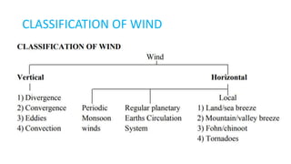
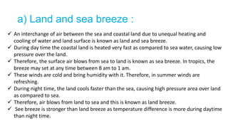
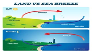
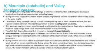
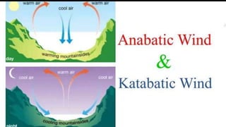
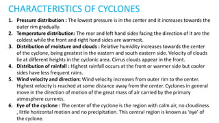
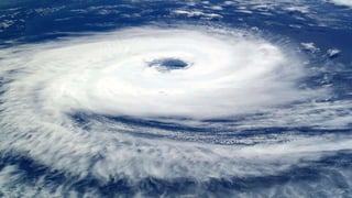
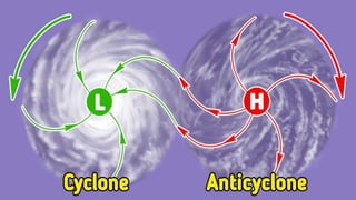
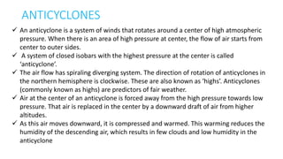
The document discusses various types of winds including local winds like sea breezes and mountain breezes that are influenced by local conditions. It also describes global winds such as trade winds, westerlies, and polar winds that are influenced by factors like the Earth's rotation and heating from the sun. Cyclones are defined as low pressure storm systems where winds spiral inward towards the center. Key characteristics of cyclones include a circular wind pattern and decreasing atmospheric pressure from the outer edge to the center.
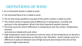
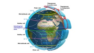
Chirkey and foorkey disease of cardamom Suraj Poudel
This is a slide prepared about two viral diseases of Cardamom by me and sushil for classroom presentation of Pathology. All the photos inserted in this slides are downloaded from the internet and belongs to respective uploader.
Integrated Nutrient Management refers to maintenance of soil fertility and the plant nutrient supply at an optimum level for sustaining the desired productivity through optimization of the benefits from all the possible sources of Organic, Inorganic & biological component in an integrated manner.
Mechanism of insect resistance in plants (non preference, antibiosis, tolerance and avoidance) – nature of insect resistance – genetics of insect resistance – horizontal and vertical – genetics of resistance – sources of insect resistance – breeding methods for insect resistance – problems in breeding for insect resistance – achievements.
Pest of Onion, Thrips tabaci commonly known as onion thrips. It is a severe pest where both nymphs and adults suck the growing foliage of onion plant due to which decline the growth of the plant.
Practical on Weed Identification of Kharif Crops by Dr.G.S.TomarDrgajendrasinghtomar
Procedure for identification of Common Weeds occurs in kharif season. Common name, growth habit and habitat of weed occurrence is given for the benefit of students and faculties of Agriculture. Presented by Dr.G.S.Tomar, Professor (Agronomy), IGAU, Raipur.
In this presentation you will come to know about the HANDLING OF SEGREGATING GENERATIONS, that is (PEDIGREE METHOD, MASS PEDIGREE METHOD, BULK METHOD, SINGLE SEED DESCENT METHOD).
The climate of a region is ultimately determined by the radiation energy of the sun, and its distribution and temporal fluctuations. The long-term state of the atmosphere is a function of a variety of interacting elements. They are: Solar radiation, Air masses, Pressure systems (and cyclone belts),Ocean Currents, and topography.
Wind is the natural movement of air in the Earth's atmosphere. It is caused by the uneven heating of the Earth's surface by the sun, which creates differences in air pressure. As air moves from areas of high pressure to areas of low pressure, it creates what we perceive as wind. Here are some key characteristics and descriptions of wind:
Direction: Wind is described by the direction from which it is blowing. For example, a north wind blows from the north to the south.
Speed: Wind speed is typically measured in units such as meters per second (m/s), kilometers per hour (km/h), or miles per hour (mph). The speed of the wind can vary widely, from calm conditions with barely perceptible breezes to strong gusts during a storm.
Strength: Wind strength is often classified on various scales, such as the Beaufort Scale, which ranges from calm (0) to hurricane force (12). Each level on the scale corresponds to a range of wind speeds and their effects on the environment.
Gusts: Wind gusts are sudden, brief increases in wind speed that can be significantly stronger than the prevailing wind. Gusts are often associated with weather events like thunderstorms or frontal passages.
Effects: Wind can have various effects on the environment, including:
Erosion: Strong winds can erode soil and affect the landscape over time.
Transportation: Wind can impact travel, especially for vehicles like airplanes and sailboats.
Weather: Wind plays a crucial role in weather patterns, helping to distribute heat and moisture around the globe.
Energy: Wind can be harnessed as a renewable energy source through wind turbines to generate electricity.
Local Patterns: Wind patterns can vary greatly depending on geographic location and terrain. For example, coastal areas often experience onshore and offshore winds influenced by the proximity of the ocean, while mountainous regions may have unique wind patterns due to the interaction with the terrain.
Wind Chill: Wind can make the air feel colder than the actual temperature because it enhances heat loss from the body. This effect is known as wind chill, and it's important to consider in cold weather.
Windsocks and Wind Vanes: Wind direction is often indicated using windsocks or wind vanes, which are instruments that show the prevailing wind direction.
Wind in Meteorology: Meteorologists study wind patterns and speeds as a critical part of weather forecasting. Understanding wind helps predict weather changes, storm development, and atmospheric circulation.
In summary, wind is the movement of air caused by differences in air pressure, and it plays a vital role in our daily lives, weather patterns, and various natural processes.
This document looks at the factors that affect weather and climate. The weather systems that also affect the Caribbean is also examined. These include ITCZ, Hurricanes, Cold Fronts, Easterly waves, Anticyclones
Normal Labour/ Stages of Labour/ Mechanism of LabourWasim Ak
Normal labor is also termed spontaneous labor, defined as the natural physiological process through which the fetus, placenta, and membranes are expelled from the uterus through the birth canal at term (37 to 42 weeks
Welcome to TechSoup New Member Orientation and Q&A (May 2024).pdfTechSoup
In this webinar you will learn how your organization can access TechSoup's wide variety of product discount and donation programs. From hardware to software, we'll give you a tour of the tools available to help your nonprofit with productivity, collaboration, financial management, donor tracking, security, and more.
Introduction to AI for Nonprofits with Tapp NetworkTechSoup
Dive into the world of AI! Experts Jon Hill and Tareq Monaur will guide you through AI's role in enhancing nonprofit websites and basic marketing strategies, making it easy to understand and apply.
Read| The latest issue of The Challenger is here! We are thrilled to announce that our school paper has qualified for the NATIONAL SCHOOLS PRESS CONFERENCE (NSPC) 2024. Thank you for your unwavering support and trust. Dive into the stories that made us stand out!
Honest Reviews of Tim Han LMA Course Program.pptxtimhan337
Personal development courses are widely available today, with each one promising life-changing outcomes. Tim Han’s Life Mastery Achievers (LMA) Course has drawn a lot of interest. In addition to offering my frank assessment of Success Insider’s LMA Course, this piece examines the course’s effects via a variety of Tim Han LMA course reviews and Success Insider comments.
Acetabularia Information For Class 9 .docxvaibhavrinwa19
Acetabularia acetabulum is a single-celled green alga that in its vegetative state is morphologically differentiated into a basal rhizoid and an axially elongated stalk, which bears whorls of branching hairs. The single diploid nucleus resides in the rhizoid.
Embracing GenAI - A Strategic ImperativePeter Windle
Artificial Intelligence (AI) technologies such as Generative AI, Image Generators and Large Language Models have had a dramatic impact on teaching, learning and assessment over the past 18 months. The most immediate threat AI posed was to Academic Integrity with Higher Education Institutes (HEIs) focusing their efforts on combating the use of GenAI in assessment. Guidelines were developed for staff and students, policies put in place too. Innovative educators have forged paths in the use of Generative AI for teaching, learning and assessments leading to pockets of transformation springing up across HEIs, often with little or no top-down guidance, support or direction.
This Gasta posits a strategic approach to integrating AI into HEIs to prepare staff, students and the curriculum for an evolving world and workplace. We will highlight the advantages of working with these technologies beyond the realm of teaching, learning and assessment by considering prompt engineering skills, industry impact, curriculum changes, and the need for staff upskilling. In contrast, not engaging strategically with Generative AI poses risks, including falling behind peers, missed opportunities and failing to ensure our graduates remain employable. The rapid evolution of AI technologies necessitates a proactive and strategic approach if we are to remain relevant.
Francesca Gottschalk - How can education support child empowerment.pptxEduSkills OECD
Francesca Gottschalk from the OECD’s Centre for Educational Research and Innovation presents at the Ask an Expert Webinar: How can education support child empowerment?
How to Make a Field invisible in Odoo 17Celine George
It is possible to hide or invisible some fields in odoo. Commonly using “invisible” attribute in the field definition to invisible the fields. This slide will show how to make a field invisible in odoo 17.
1. INTRODUCTORY AGRO-METROLOGY
AND CLIMATE CHANGE
(AGRO-112)
Sharadchandraji Pawar institute Of Agricultural Sciences
Mr. Kaival J Patel
Assistant Professor
Department ofAgronomy
Sharadchandraji Pawar institute Of
Agricultural Sciences, Ratnagiri.
Sharadchandraji Pawar institute Of Agricultural Sciences
2. Lecture- 4
WINDS - TYPES , DAILY AND SEASONAL
VARIATION OF WIND SPEED,
CYCLONES, ANTICYCLONES, LAND BREEZE AND
SEA BREEZE
DEFINITIONS OF WIND
3. DEFINITIONS OF WIND
1. Air in horizontal motion is called as wind.
2. The horizontal flow of air is called as wind.
3. The air that moves parallel to any part of the earth’s surface is called as wind.
This motion tends to equalize lateral differences in temperature, humidity and
pressure in the atmosphere. Wind is the third important weather element.
The main cause for wind is differences in temperature over the surface. Temperature,
pressure
and wind are related with each other.
High temperature means low pressure and vice versa. At low temperature air density is
high while at high temperature are density is low. Therefore , wind is always result of a
difference in pressure between area of high pressure (low temp) to the area of low
pressure (high temperature).
4. Air current -
Vertically or nearly vertical movements of air resulting from convection, turbulence or any other
cause is known as air current.
Vertical movement is noticed but it is negligible when compared to horizontal movement as the
height of the atmosphere is only for few kilometers. However only vertical movement or uplift of
air causes significant weather changes i.e. cloud formation and rain.
Wind is always the result of a difference in pressure between two areas, the movement of air
being from the area of higher pressure to area of lower pressure, the principle cause for the
production of wind is difference in temperature over the surface, temperature, pressure and wind
are related with each other.
Measurement of wind velocity -
Wind speed or velocity is measured by an instrument called as anemometer. Units are knot,
meter/second, feet/second, km/hr and miles/ hr.
Beaufort scale of wind was designed by admiral Beaufort in 1805. It has 12 points (or 16). The
velocity as well as strength of the wind can be estimated by this.
The approximation formula for conversion of Beaufort scale number into meter/sec, is as gives
below
Velocity in meter/second = 2 X Beaufort number-1
5.
6. IMPORTANCE / ROLE / EFFECTS OF
WINDS IN AGRICULTURE
Wind increase the transpiration and intake of CO2 .
The turbulence created by wind increase CO2 supply and the increase in
photosynthesis.
When wind is hot, desiccation of the plants takes place, because humid air in the inter
cellular places is replaced by dry air.
The hot and dry wind makes the cells expanding and early maturity, it results in the
dwarfing of plants.
Under the influence of strong wind the shoots are pressurized and get deformed.
Strong winds produces lodging of crops.
Strong winds affect the plants life both mechanically and physiologically.
The coastal area affected by strong wind brings salt and make the soil unsuitable for
growing plant.
7. Wind also alters the balance of hormones. (Wind increases ethylene production
in barley and rice Wind decreases gibberellic acid content of roots and shoots in
rice.
Light and gentle winds are helpful for cleaning the agricultural produce.
Hot dry winds frequently do much damage to the growing crops by promoting
excessive water loss.
Wind provides moisture which is necessary for the precipitation.
Strong wind causes lodging. Very common in crops, such as maize, wheat and
sugarcane. Strong surface wind may break the twigs and shed. the fruits of many
plants. Plants with shallow roots are often uprooted.
10. 1.Local Winds
These winds are generated due to local conditions and have influence over very small
area, therefore, such winds are called as local winds
Local winds are those that are created as a result of scenery such as mountains,
vegetation, water bodies and so on.
They usually change very often and the weather forecast people talk about this kind on
the TV every day.
They can move from mild to extreme winds in just hours.
Good examples of local winds are sea breezes and land breezes, and mountain and
valley breezes.
Local winds cover very short distances.
11. a) Land and sea breeze :
An interchange of air between the sea and coastal land due to unequal heating and
cooling of water and land surface is known as land and sea breeze.
During day time the coastal land is heated very fast as compared to sea water, causing low
pressure over the land.
Therefore, the surface air blows from sea to land is known as sea breeze. In tropics, the
breeze may set at any time between 8 am to 1 am.
These winds are cold and bring humidity with it. Therefore, in summer winds are
refreshing.
During night time, the land cools faster than the sea, causing high pressure area over land
as compared to sea.
Therefore, air blows from land to sea and this is known as land breeze.
See breeze is stronger than land breeze as temperature difference is more during daytime
than night time.
12.
13. b) Mountain (katabatic) and Valley
(anabatic)breeze:
They are present is hilly areas. An interchange of air between the mountain and valley due to unequal
heating & cooling is known as mountain and valley breeze.
During day time, slopes of mountains receive direct sunlight hence become hotter than other nearby places
at the same height.
The warm air along the slope rises up to reach the neighboring area at about the same altitude, but less
exposed to solar radiation. The ascending warm air is called as valley winds (anabatic).
This warm air may form clouds round the peak resulting in the afternoon showers. Reversely, at night time
slope will loose energy much faster and becomes colder than surrounding.
This chilled air descend downward . It is known as mountain breeze (katabatic) .
Monsoon winds : An interchange of air between the land and oceans due to Valley and mountain breeze
unequal heating and cooling of continents and ocean is known as Monsoon winds. It has annual period of
occurrence.
During summer the land is heated as compared to an ocean which causes low pressure over the land and the
winds blow from oceans to continents. During winter the lands cooled down faster than the oceans causing
high pressure over continents and low pressure over oceans and therefore winds blow from continents to
oceans. The Indian monsoon is the best example of this alternate circulation system.
14.
15. c) Fohn and Chinook winds:
Like katabatic winds, they are down slope breezes but, instead of being
dry and cold like katabatic, they are dry and warm.
They develop on leeward side of the mountain range, when stable air is
forced to flow over the barriers by the regional pressure gradient.
Fohn winds are common in Alps in Europe, whereas, Chinook are
common in rocky North America.
16. d) Tornadoes :
These are smallest, most violent and destructive of all storms.
Funnel shaped having small diameter(10mt) and moving with very high
velocity about 500 miles/ hr. are the characteristics of tornadoes .
Where, the funnel clouds touch the ground, there is complete destruction
at about 900 – 1200 ft wide.
These are small eddies of intense turbulence generated by the mixing of
dry polar air masses with moist, warm tropical air. This is the feature of
American weather.
17. Forces acting to produce wind -
There are unbalanced forces on earth which are responsible for the movement of
wind. Different types of forces responsible for the flow of the wind are as given
below
1.Horizontal pressure gradient (HPG) force
2.Coriolis force.
3.Centrifugal force.
4.Frictional force.
5.Geo strophic winds.
18. 1.Horizontal pressure Gradient (HPG) - The rate of decrease of pressure or change in it between
two points at same altitude is called as pressure gradient. It is proportional to the difference in
pressure and responsible for the horizontal air movement. Air flows from higher pressure to lower
pressure and speed is directly concern with pressure gradient. In case of hich rate of change pressure
gradient is steep. The direction of PG is perpendicular to the isobars and pointing at low pressure.
2.Coriolis force or earth's rotational deflective force - As we all know that earth rotates on it's axis,
this rotation of earth creates a force that is the coriolis force. It's major role is in wind direction. Due to
this force in northern hemisphere wind get deflect towards right while in southern hemisphere to left. It
increases from equator towards the poles. This force is responsible to changes in wind direction and
not for wind speed.
3.Centrifugal force - Uniform circular motion is an accelerated motion. Obviously, a particle
performing this motion is in an accelerated frame of reference and therefore a pseudo -force acts on
the particle, this pseudo-force is called as the centrifugal force.
19. 4. Frictional force - The surface of earth or topography, variation in the
topography which includes other infrastructures of man-made viz. buildings,
dams, etc. and trees and other irregularities this is responsible for the resistance
(frictional) to the wind. As it resists the air motion therefore reduces the wind
speed.
5.Geostrophic wind - Wind which flows because of only forces acting are
coriolis pressure gradient forces. This wind flows in straight line witheut frictional
force on it.
20.
21.
22.
23. 2. Global Winds
Global winds are really large air masses that are
created mainly as a result of the earth’s rotation, the
shape of the earth and the sun’s heating power.
24. a) Trade winds :
The condition of greatest heating and expansion at the equator, causes rising of air and
creating low pressure belt [5° N to 5° S latitude] is known as “doldrum” or “equatorial
low” or “calm”.
The rising air from equator causes increase in pressure at 35° N and 35°S latitude.
Therefore, reduction in surface pressure on equator and increase in pressure at 35°N
and 35° S which is known as subtropical high or Horse latitudes.
Therefore, wind flow from the horse latitudes to the equatorial region. They are called
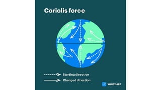
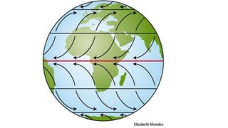
as trade winds. While moving, these winds are deflected by Coriolis force to the right in
northern hemisphere and to left in the southern hemisphere.
Thus, these winds flow from 35° N to the equator in the direction North East in
Northern hemisphere while they move in South East direction in southern hemisphere,
these winds are known as North East trade and South East trades respectively. The force
is 10 – 20 mph
25.
26. b) Westerlies or Antitrade winds :
The wind that flow from sub-tropical high (high pressure area i.e. horse latitude in
both the hemisphere) to the low pressure area at about 60° to 70° latitude in both
the hemisphere (sub polar low) are known as Westerlies or prevailing westerlies or
antitrade winds.
These winds instead of flowing in straight line are deflected due to Coriolis force. In
Northern hemisphere, their direction is North-West and in the Southern hemisphere,
it is South-West.
Winds are forceful and change their direction frequently. In the southern hemisphere
at 40° to 65°S,the winds are violent and have high frequency creating large noise.
Therefore, the latitude is known as Roaring Forties.
27. c) Polar winds or polar easterlies :
High pressure area exist on the poles which is intensified by the extreme
cold.
Therefore, wind flows from the polar high to sub polar low pressure area
at about 60° to 65° latitude.
The winds flow North East direction in Northern hemisphere and South
East direction in Southern hemisphere. It is called as polar winds or polar
easterlies. These winds consist of cold air.
28. 3.Doldrums
This is the very low pressure area along the equator where prevailing winds are calmest.
This low-pressure area is caused by the constant heating of the sun. This belt extends to
about 5° north and south of the equator.
Tropical Easterlies (Trade Winds): This is the belt extending as far as 30° north and south
latitude of the Inter- tropical Convergence Zone (ITCZ).
Horse Latitudes: This is wind belt that forms at about 30° north and south latitude
between the trade winds and the prevailing Westerlies Above are some standard wind
belts with the white arrows showing the direction of winds, red arrow showing vertical
rising air, and blue arrow showing cold sinking air.
Prevailing Westerlies: This is the belt extending from 30° to 60° latitude from the ITCZ.
Polar Easterlies: This belt covers from 60° latitudes to the north and south poles.
AIR CURRENT : Vertical or nearly vertical movement of air resulting from convection,
turbulence or any other cause referred as air current.
Isotech : This is the line on the weather map joining places at equal wind speed.
29.
30. Periodic wind or monsoon winds: -
An interchange of air between the land and oceans due to unequal heating
and cooling of continents and oceans in known as monsoon winds.
It has an annual period of occurrence. There are two types of monsoons over
India
(1) SW monsoon and
(2) NE monsoon.
31. 1. South-west monsoon
During SW monsoon period of june to September, the westerly winds prevail on
the west of Kerala and south winds on the East of northern Orissa and Bengal.
The south west monsoon period is called grand period of rainfall in India.
Regular monsoon system is developed due to physiographic features. When
south-east trade winds start from the south of equator, they travel over Indian
ocean, and absorb large amounts of moisture.
When these winds trying to cross the equator they get disturbed due to air
circulation over India and get converted into the south-west winds. Then these
wind with high amount of moisture forward to India with violent thunder and
lightning. And at the coastal region of India (Kerala) they reach near about first of
June every year with sudden break of monsoon.
32.
33. 2. North-east monsoon -
During winter (Nov-Jan) it occurs. In China and Russia cool climate during,
winter result into the high-pressure areas.
At this time dry light winds blow from these land to low-pressure areas in
India. The direction of these winds is the north easterly.
Northeast winds or monsoon is nothing but the trade winds, which normally
blow over India.
34.
35. CYCLONES
A cyclone is a storm or system of winds that rotates around a center of low
atmospheric pressure. It is the atmospheric disturbance in which the air
pressure decreases at a particular location and there is movement of air
towards center.
A system of close isobars with the lowest pressure at the center is called
cyclone. It is a barometric depression wherein the pressure decreases from its
outer rim to its center.
The velocity of wind is more than 34 knots. In cyclones, air close to the ground
is forced inward toward the center of the cyclone, where pressure is the lowest.
It then begins to rise upward, expanding and cooling in the process.
36. This cooling increases the humidity of the rising air, which results in cloudiness
and high humidity in the cyclone.
The pressure gradient force and Coriolis force cause air flow in cyclone to spiraling
convergent system.
In cyclone, the winds blow in a circular manner in clockwise direction in the
southern hemisphere and in anticlockwise direction in the northern hemisphere.
Cyclones are also known as ‘lows’ or ‘depressions’. Cyclones (commonly known as
lows) generally are indicators of rain, clouds, and other forms of bad weather.
37. CHARACTERISTICS OF CYCLONES
1. Pressure distribution : The lowest pressure is in the center and it increases towards the
outer rim gradually.
2. Temperature distribution: The rear and left hand sides facing the direction of it are the
coldest while the front and right hand sides are warmest.
3. Distribution of moisture and clouds : Relative humidity increases towards the center
of the cyclone, being greatest in the eastern and south eastern side. Velocity of clouds
lie at different heights in the cyclonic area. Cirrus clouds appear in the front.
4. Distribution of rainfall : Highest rainfall occurs at the front or warmer side but cooler
sides have less frequent rains.
5. Wind velocity and direction: Wind velocity increases from outer rim to the center.
Highest velocity is reached at some distance away from the center. Cyclones in general
move in the direction of motion of the great mass of air carried by the primary
atmosphere currents.
6. Eye of the cyclone : The center of the cyclone is the region with calm air, no cloudiness
, little horizontal motion and no precipitation. This central region is known as ‘eye’ of
the cyclone.
38.
39.
40. ANTICYCLONES
An anticyclone is a system of winds that rotates around a center of high atmospheric
pressure. When there is an area of high pressure at center, the flow of air starts from
center to outer sides.
A system of closed isobars with the highest pressure at the center is called
‘anticyclone’.
The air flow has spiraling diverging system. The direction of rotation of anticyclones in
the northern hemisphere is clockwise. These are also known as ‘highs’. Anticyclones
(commonly known as highs) are predictors of fair weather.
Air at the center of an anticyclone is forced away from the high pressure towards low
pressure. That air is replaced in the center by a downward draft of air from higher
altitudes.
As this air moves downward, it is compressed and warmed. This warming reduces the
humidity of the descending air, which results in few clouds and low humidity in the
anticyclone
41. CHARACTERISTICS OF ANTICYCLONES
1. Air pressure : The high pressure center enclosed by isobars decreasing in pressure
in oval or elliptical shape is known as anticyclones. They are just opposite to
cyclones. They bring fare weather and move in clockwise direction in northern
hemisphere. Pressure decreases from center to periphery. Dimensions of
anticyclones exceed those of cyclones.
2. Moisture in anticyclones : Anticyclones are associated with dry, cool air, little cloud,
slight precipitation. Air descends at the center, therefore, temperature increases
relative humidity decreases and clouds are dissipated.
3. Temperature in anticyclones : Temperatures near the ground in anticyclones are
lower than the normal air temperatures. At higher altitudes temperatures are
generally higher.
4. Direction and velocity of wind : At ground air spirally rushes outward from the
center to periphery. Wind velocities are much lesser than in cyclones. Anticyclones
move along with the general direction of the great air currents.