This document summarizes a research paper on examining public accessibility to the Kuala Lumpur waterfront in Malaysia. It begins by providing background on the importance of waterfronts historically and how their uses have changed. It then discusses 4 attributes related to public accessibility at waterfronts. The paper aims to evaluate public perceptions of accessibility at the Kuala Lumpur waterfront using focus groups. 12 members of the public participated in focus groups to share their experiences and views. The findings aim to inform future development and policies regarding public access to the waterfront.
![waterfront’s open space (Wakefield, 2007; Desfor and Jorgensen, 2004; Hoyle, 2000; Meyer,
1999; Hoyle, 1994; Fainstein, 2001; Hayuth, 1988). This is due to the private development
that has taken place at the waterfront area, which has denied both direct and visual access.
This is also consistent with the study conducted by Buit (in Knaap and Pinder, 1992, p.165),
which analysed the impact of twenty-eight major renewal developments throughout Europe
that include waterfront projects. He found that there were more disappointments compared to
those that had a positive impact. One major factor that is apparent, is the lack of consideration
concerning the accessibility of the residential environment with the river.
Tibbalds (1992) highlighted that in making a particular place responsive for activities to
happen it must allow clarity in the accessibility to the area, event or facilities. According to
Boyd (1985, p.39), and agreed by Laidley (2007), in many cities the public accessibility to the
water’s edge has succumbed to the value of the land that is exclusive for private development
due to the waterfront locations. Boyd opined that there would be no impact in the process of
design review if the public access is provided just to fulfil the requirement set legally and that
can be satisfied with any ‘uninviting’ pathway without giving it sufficient thoughts.
Based on the research of three main waterfront transformation phases that most
waterfront cities experience [a) phase one: waterfront establishment; b) phase two: the decline
of waterfront and c) phase three: waterfront awareness], there are four main attributes that can
be related to the public accessibility to the waterfront. These are i) direct access to water ii)
continuous linkage along the water iii) link waterfront to the city and iv) visual accessibility.
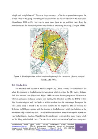
2 The Kuala Lumpur research
2.1 Aims
Although this is a widely discussed and debated issue globally, studies at the local level
cannot be ignored because the issue has to be treated on a case by case and locality basis
(Riley and Shumer-Smith, 1988). This study is imperative for the urban development of
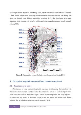
Kuala Lumpur, which is the largest city in Malaysia and has the longest waterfront area
(along urban rivers) within the city centre. As mentioned by Worskett (1969), the essence and
character of the other smaller towns can usually be found in the city centre (Worpole, 1992 in
Shamsuddin, 1999). The magnitude of the problems involved in the city centre of a capital
314 Nurul Syala Abdul Latip and Shuhana Shamsuddin](https://image.slidesharecdn.com/311-331-121122235947-phpapp02/85/Kuala-Lumpur-Waterfront-A-Public-Place-for-All-4-320.jpg)
![waterfront to the city, continuity of pedestrian linkages along the waterfront) nor the visual
accessibility in some areas in the zones highlighted above were preserved for this purpose.
Therefore, this research suggests that it would be imperative for future waterfront
development to give due consideration on legibility factors to allow the waterfront to be more
accessible for the public to benefit from it.
5 Acknowledgement
The authors would like to thank The International Islamic University of Malaysia,
Universiti Teknologi Malaysia and The Ministry of Science, Technology and Innovation
Malaysia for their contributions and support of this research.
6 References
Abdul Latip, N.S., 2011. Contextual integration in waterfront development. PhD Thesis, The
University of Nottingham, UK.
Anon., 2003a. Checking troubled waters. Star Online [online]. [viewed 12 March 2008].
Available from: http://www.ecologyasia.com/news-archives/2003/feb-
03/thestar_20030208_3.htm.
Anon., 2006. River pollution: Humans are the main culprit. Bernama [online]. [viewed 7 June
2008]. Available from: www.bernama.com.my.
Anon., 2008. Klang river basin environmental improvement and flood mitigation project
Asian Development Bank [online]. [viewed 27 May 2008]. Available from:
http://www.adb.org/Documents/Books/Env_and_Eco/malaysia.pdf
Appleyard, D. and Lintell, M., 1972. The environmental quality of city streets: The residents'
viewpoint. Journal of American Planning Association, 38(2): 84-101.
Boyd, M.W., 1985. Coastal Regulations: Assuring Access to California Coast. In: J.E. Petrillo
and P. Grenell (Eds.), The Urban Edge. Where the City Meets the Sea. The California
State Coastal Conservancy and William Kaufmann Inc., USA, pp. 32-41.
Breen, A. and Rigby, D., 1994. Waterfronts cities reclaim their edge. McGraw-Hill Inc., USA.
Breen, A. and Rigby, D., 1996. The new waterfront: A worldwide urban success story.
Thames and Hudson, Great Britain.
Buchanan, P., 1988. What a city? A plea for place in the public realm. Architectural review,
184(1101): 31-41.
Burton, E. and Mitchell, L., 2006. Inclusive urban design. Streets for life. Architectural press,
Oxford.
Carmona, M. and Tiesdell, S. (Eds.), 2007. Urban design reader. Architectural press, Oxford,
UK.
328 Nurul Syala Abdul Latip and Shuhana Shamsuddin](https://image.slidesharecdn.com/311-331-121122235947-phpapp02/85/Kuala-Lumpur-Waterfront-A-Public-Place-for-All-18-320.jpg)
![Riley, R. and Shumer-Smith, L., 1988. Global imperatives, local forces and waterfront
redevelopment. In: B. Hoyle, D. Pinder and M. Husain (Eds.), Revitalising the
waterfront: International dimensions of Dockland redevelopment
John Wiley & Sons Inc, Great Britain.
Shamsuddin, S., 1999. Identity of place. Phd Thesis, University of Nottingham, Nottingham,
326 pp.
Stefanovic, I.L., 2002. The Lake Ontario waterfront trail, Canada: Integrating natural and
built environment. Ekistics, 415(July/August ): 304-316.
Tibbalds, F., 1988. 'Urban design: Tibbalds offers the Prince his ten commandments'. The
Planner, 74(12): 1.
Tibbalds, F., 2001. Making people-friendly towns: Improving the public environment in
towns and cities. Taylor & Francis, London.
Wakefield, S., 2007. Great expectations: Waterfront redevelopment and the Hamilton
Harbour waterfront trail. Cities [online]. [viewed 20 April 2007]. Available from:
doi:10.1016/j.cities.2006.11.001.
West, N., 1989. Urban waterfront developments: A geographic problem in search of a model.
Geoforum, 20(4): 459-468.
Worpole, K., 1992. Towns for people. Open University Press.
Worskett, 1969. The character of town. London Architectural Press, London.
Dr.Nurul Syala Abdul Latip is a lecturer of Department of Architecture at International Islamic
University Malaysia. She received her B. Arch (Hons) from Universiti Teknologi Malaysia in 2000 and
her Master in Sustainable Development at University of New South Wales, Australia in 2002. She
obtained her PhD in Architecture at University of Nottingham, UK. Her current interests involve urban
design, heritage studies and sustainable development.
Dr. Shamsuddin is an Associate Professor at the Razak School of Engineering and Advanced
Technology, Universiti Teknologi Malaysia International Campus, Kuala Lumpur. She is the Head of
Green Cities and Construction Research Group, Construction Research Alliance, UTM and Program
Coordinator for Msc Sustainable Urban Design in Razak School. She specialises in urban design and has
published many books and papers internationally. She has won a bronze medal for her research, the
Royal Town Planning Institute UK prize for academic excellence and featured as a distinctive researcher
in a poster exhibition on ‘Women and Science’ at the Malaysian National Science Centre.
Peer Review: This article has been internationally peer-reviewed and accepted for publication
according to the guidelines given at the journal’s website. Note: This article
was accepted and presented at the 2nd International Conference-Workshop on
Sustainable Architecture and Urban Design (ICWSAUD) organized by School
of Housing, Building & Planning, Universiti Sains Malaysia, Penang, Malaysia
from March 3rd -5th, 2012.
*Corresponding author (Nurul Syala). Tel/Fax: +03-61966219 E-mail addresses:
alnsyala@iium.edu.my. 2012. International Transaction Journal of Engineering,
Management, & Applied Sciences & Technologies. Volume 3 No.3 ISSN 2228-9860 331
eISSN 1906-9642. Online Available at http://TuEngr.com/V03/311-331.pdf.](https://image.slidesharecdn.com/311-331-121122235947-phpapp02/85/Kuala-Lumpur-Waterfront-A-Public-Place-for-All-21-320.jpg)


