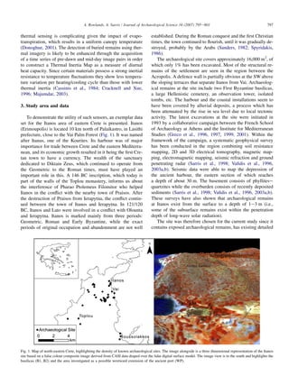
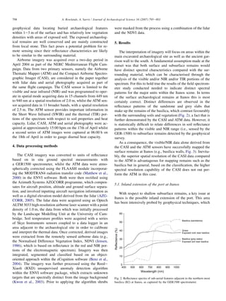
This document discusses using multi-sensor remote sensing to detect exposed and subsurface archaeological remains in eastern Crete. It summarizes how hyperspectral imaging, thermal imaging, and lidar were used individually and together to map surface structures and detect anomalies underground that could indicate buried remains. While surface mapping was mostly successful, detecting subsurface remains proved more difficult, though thermal data showed the most promise. The study demonstrated the value of combining different sensor types to gain more archaeological information than from any single sensor alone.
![2. Remote sensing of archaeology
Depending on their configuration, multi- and hyperspectral
data captured from both airborne and spaceborne platforms
are attractive since they can detect electromagnetic radiation
in the visible and beyond into the infrared and the thermal.
With technological improvements, the higher spatial and spec-
tral resolutions previously only attainable through airborne
remote sensing are increasingly becoming available on space-
borne platforms [e.g., Hyperion (Krusel, 2003)]. Multi-spectral
sensors such as Landsat and SPOT acquire data in broad
(w100e200 nm) irregularly spaced spectral bands (van der
Meer and de Jong, 2001). Consequently, narrow spectral fea-
tures may not be readily discriminated due to averaging across
the spectral sampling range or masked by stronger features
(Kumar et al., 2001). The net effect is the reduction or loss
in the information that can potentially be extracted. Hyperspec-
tral sensors, comprising tens to hundreds of bands, are able to
retrieve near-laboratory quality reflectance spectra such that
the data associated with each pixel approximate the true spec-
tral signature of a target material (Lucas et al., 2004). Given the
cost implications of acquiring such imagery, the question
arises; is it necessary to opt for both high spectral and spatial
resolution imagery for archaeological applications? This paper
addresses these issues and highlights the need to consider both
the scale of the archaeological remains as well as their distinc-
tiveness spectrally.
A number of different satellite sensors have been employed
in a variety of archaeological applications spanning the iden-
tification of spectral signatures within archaeological sites
(with direct consequences for predictive modelling) to the
mapping of subsurface remains and the management and pro-
tection of archaeological sites (Ebert and Lyons, 1980; Custer
et al., 1986; Madry and Crumley, 1990; Cooper et al., 1991;
Liu et al., 2003a; Sarris et al., 1996). Typically these are based
on low spectral and spatial resolution imagery [e.g., Landsat
(Custer et al., 1986; Clark et al., 1998), SPOT (Clark et al.,
1998; Sarris and Jones, 2000; Tripathi, 2005) and ASTER
(Altaweel, 2005)]. Recently, high spatial resolution satellite
imagery from the Ikonos and Quickbird sensors have been em-
ployed for the recognition of settlements and shallow depth
monuments (Sarris, 2005b). The mapping of potential ancient
settlements from former river courses through the identification
of spectrally distinctive deposits (Gore, 2004) and the identifi-
cation of surface archaeological remains directly (Parcak,
2004) are indicative of the range of remote sensing work previ-
ously conducted. Increasingly remote sensing, and time series
remote sensing in particular, is being utilised for archaeological
resource management/cultural resource management [e.g., to
monitor encroachment onto sites due to population or agricul-
tural pressures (Changlin et al., 2004; Raczkowski, 2004)].
Other applications include the use of multiple polarisation
data from the Shuttle Imaging Radar (SIR-A, SIR-C) to provide
evidence of palaeochannels in arid environments to locate areas
that could have sustained settlements (McCauley et al., 1982;
El-Baz, 1998), Radarsat Synthetic Aperture Radar (SAR) im-
agery for studying mound sites and canal systems (Richason,
1998), and the use of declassified intelligence satellite imagery
for the construction of an archaeological GIS (Mathys, 1997).
The latter, with emphasis on CORONA images, are increas-
ingly used in archaeological applications (Philip et al., 2002;
Ur, 2003; Fowler and Fowler, 2005; Goossens et al., 2006).
Images derived from remote sensing then become important
data layers within a Geographical Information System permit-
ting monitoring and conservation plans to be implemented
(Shupeng, 2004).
In addition to mapping surface remains, buried archaeology
may cause anomalies in the characteristics of the overlying
soil, which can be detected by remote sensing in the visible,
near infrared and the thermal. The presence of buried remains
is likely to alter the physical and chemical characteristics of
the soil compared with those of the surroundings due to
changes in soil depth and variations in drainage. However,
extraction of soil-based information from remotely sensed
sources is complicated by the presence of vegetation, which
(a) obscures the pure soil signature and (b) attenuates electro-
magnetic radiation at most wavelengths (Tucker and Miller,
1977). Even in semi-arid regions dead vegetation masks soil
reflectance with soil discrimination being lost at between
50% and 60% vegetation cover (Murphy and Wadge, 1994).
Studies have demonstrated that hyperspectral remote sensing
can retrieve information such as soil moisture content (Liu
et al., 2003b), temperature and texture/surface roughness and
given the distinct spectral signatures of minerals, have played
a key role in identifying and mapping soils (Leone and
Escadafal, 2001; Ben-Dor et al., 2002; Chabrillat et al.,
2002; Metternicht and Zinck, 2003).
Although the case for the application of thermal imagery
to detect buried features is well established, relatively limited
use is made of thermal remote sensing within an archaeolog-
ical context (e.g., Bellerby et al., 1990; Ben-Dor et al., 2001)
but it has attracted more attention in the analogous applica-
tion of sensing buried military ordnance, particularly mines
(Maathuis and van Genderen, 2004). The principal premise
for both is that heat transfer through the soil will be affected
by the presence of buried objects (Maathuis and van Genderen,
2004). Shallow buried remains may be ideal targets for ther-
mal sensors provided that they exist within the penetration
depth of long-wave solar radiation (Nash, 1988) and if other
factors such as the thermal characteristics of buried objects
and the surrounding medium are favourable (Ben-Dor et al.,
2001). In semi-arid regions, such as the study area, remains
at deeper levels (i.e., several metres in depth), will be beyond
the range of long-wave solar radiation and will only be
detectable with sensors operating at microwave wavelengths
(i.e., radar).
In the case of detecting buried ordnance, the nature of the
target object is likely to have distinct thermal properties
from the surrounding media; however, this may not necessarily
be the case for archaeological remains. Environmental factors
such as the compaction of soil (Winter et al., 1997), moisture
content (Simard, 1996) and vegetation (Bishop et al., 1999)
will impact on the effectiveness of the technique to detect sub-
surface remains. The presence of vegetation in the context of
796 A. Rowlands, A. Sarris / Journal of Archaeological Science 34 (2007) 795e803](https://image.slidesharecdn.com/1-s2-180507205027/85/1-s2-0-s0305440306001701-main-2-320.jpg)


![Heritage hetherington lidar_pdf[1]](https://cdn.slidesharecdn.com/ss_thumbnails/heritagehetheringtonlidarpdf1-100701210824-phpapp02-thumbnail.jpg?width=640&height=640&fit=bounds)


