Lab report 5 vector analysis
•Download as DOCX, PDF•
1 like•185 views

This presentation focuses on Creation of vector analysis in Arcgis of a particular area A geographic information system (GIS) is a system designed to capture, store, manipulate, analyze, manage, and present spatial or geographic data.

Recommended
Recommended
More Related Content
More from Sharik Shamsudhien
More from Sharik Shamsudhien (14)
Recently uploaded
Recently uploaded (20)
Lab report 5 vector analysis
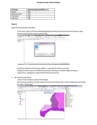
- 1. Geoprocessing: Vector Analysis . Soil Type Bearing Capacity (kN/sq. m.) Gravel 450 MediumSand 250 Fine Sand 150 SoftClay 100 Steps:1 Openfile toworkwithinArcMap. In thiscase, openD:/Practical Data/Geographical Analysis(Vector)andselectlanduse,roads, streamsand soil files streamsandsoil files. Checkthe attributesof the layersadded – especiallyforlanduse andsoil. Categorize these layersintodifferentcolorsperfieldtype if needed.(Rightclicklayer- >properties->categories->selectfieldandshow all values) 1. we needonlybushland. ‘Select’tool inAnalysistoolsof ArcToolbox. Give inputas Landuse.shp,giveoutputfilename asbushland.shp.inSql window,give command LU_type = “Bush land”
- 3. Condition:2, site shouldnotbe inhabited.Sincewe alreadyextractedbushlandoutof the map, the same done for inhabited Condition:3,the site shouldbe within500mdistance from inhabitedarea. To get the 500m bufferof inhabitedarea,we needtoseparate inhabitedareafromthe landuse map first,using‘Select’tool asbefore. Nowwe give LU_TYPE = “Inhabited”inSQLwindow. Figure: Inhabited land separated
- 4. Afterseparatinginhabitedarea,bufferthe inhabitedareaby500m. To selectsite within500mbufferof inhabitedarea,use clip tool with: Inputfile as‘bushland.shp’,Clipfeature as‘inhabited500.shp’ andoutputfile asop_clip1.shp Figure: Op_clip1.shp Condition 4:our site mustnot be within150m of streams. For this,we have to bufferstreamsby150m. Then use the erase tool to remove the portionsof the site (op_clip1.shp) thatintersectswiththe bufferedstreamfile.
- 5. To bufferstreamsby150, use buffertool Figure: streams before buffering
- 6. Nowuse the erase tool to remove the portionsof the site within150m bufferof streams: Figure:op_clip2.shp Condition 5: the site mustbe within500m of the existingroad.So,we have tobufferroadby 500m and clipour currentoutputfile op_clip2.shpwiththe bufferedroadfile. To bufferthe roadby 500m, use buffertool Thenclipthe outputfile withroadbufferfile withinputfileasop_clip2,andclipfeature asRoad500.shp
- 7. Outputfile isnamedasop_clip3.shp Figure: op_clip3.shp Condition6:To get siteswithgravel only,we have tofirstseparate gravel fromothersoil typesinthe map.
- 8. Use selecttool forseparating: Figure:Separating 'gravel' soil type
- 9. Nowto getthe portionsof the outputfile whichhave gravel,use cliptool withInputfileas ‘op_clip3.shp’andclipfeature as‘gravel.shp’ Figure:op_clip4.shp Condition:7, our site should notbe within100m of the road. To create bufferof road for 100m:
- 10. Thenusingerase tool,remove commonportions: Final op Figure:final site selected is highlighted in red color