Lab report 9 satellite image classification using Erdas imagine
•Download as DOCX, PDF•
0 likes•659 views

This presentation focuses on Creation of satellite image classification in Erdas imagine of a particular area Erdas Imagine is an image processing software package that allows users to process both geospatial and other imagery as well as vector data. Erdas can also handle hyperspectral imagery and LiDAR from various sensors.

Recommended
More Related Content
What's hot
What's hot (20)
Similar to Lab report 9 satellite image classification using Erdas imagine
Similar to Lab report 9 satellite image classification using Erdas imagine (7)
More from Sharik Shamsudhien
More from Sharik Shamsudhien (15)
Recently uploaded
Recently uploaded (20)
Lab report 9 satellite image classification using Erdas imagine
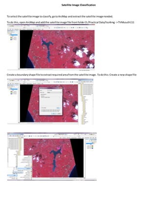
- 1. Satellite Image Classification To selectthe satelliteimage toclassify,gotoArcMap andextract the satellite imageneeded. To do this,openArcMap and addthe satelliteimage file fromfolderD:/Practical Data/liss4img ->TVMsouth111 Create a boundaryshape file toextractrequiredareafromthe satelliteimage. Todothis:Create a new shape file
- 3. Thento extractthe areaof the createdshape file fromthe satellite image,Open ArcToolbox ->Spatial Analyst->Extraction- > ExtractionbyMask. Give inputas the satellite image‘TVMsouth111’ Give inputrasteras the boundaryshape file ‘new_shapefile’ ClickOK. NowopenERDAS IMAGINEand rightclickon the screen,select‘inputrasterlayer’ –liss.img(the extractedsatellite image)
- 4. An iconwill appearonthe Lefthand side window.If the iconhasa yellow mark,rightclickonthe iconand select‘Correct the alertproblem’.ClickOK. To do supervisedclassification: Go to ‘Raster’tab on the menubar -> ‘Supervised’ ->‘Signature Editor’
- 5. Minimize the signature editorwindowandgoto ‘Drawing’tabon the menubar.
- 6. Zoomthe satelliteimage andselecteachcolorforeach feature.
- 7. Save the signature editorwindow before closing.Save asliss4.sig Thengo to ‘Raster’tab inmenubar and select‘SupervisedClassification’. - The satellite image will be automaticallyselectedasinput. - In Inputsignature,assliss4.sig - Setoutputfolderandfile name,sayclassified.img - ClickOK.
- 8. To see the classifiedimage, rightclickonscreenand ‘addraster layerto add the classifiedimage.
- 9. Rightclickon the image layerinthe Left handside window,andselect‘displayattribute table’.Here youcanselectasmany differentcolorstogetherandchange theircolorasneeded.