SlideShare a Scribd company logo
1 of 11
Krakatoa
Krakatoa (Indonesian name: Krakatau) is an active volcano in the Sunda Strait,
Indonesia. The volcano has erupted repeatedly in known history. The best known of
these events occurred in late August 1883.
The 1883 eruption ejected more than six cubic miles (25 cubic kilometers) of rock, ash,
and pumice, and made the loudest sound ever recorded by human beings. The sound
was heard as far away as Perth in Australia (3,500 km; 2,200 miles), and the island of
Rodrigues near Mauritius (4,800 km; 3,000 miles). Many thousands of people were killed
and injured by the eruption, mostly in the tsunami (giant wave) which followed the
explosion.
The pressure wave from the final explosion was recorded on barographs around the
world, which continued to register it up to 5 days after the explosion. The recordings
show that the shock wave from the final explosion reverberated around the globe
seven times.
The eruption destroyed two-thirds of what was then the island of Krakatoa. New
eruptions at the volcano since 1927 have built a new island, called Anak Krakatau
(child of Krakatoa).
Mayon Volcano
The Mayon Volcano, also known as Mount Mayon, is an active volcano in the
province of Albay, on Luzon island in the Philippines. It is a part of the Pacific
Ring of Fire. It is one the most active and dangerous volcano in the Philippines.
Mount Mayon is 2,642 metres (8,668 ft) high, and it is famous for it's "perfect
cone" shape, which attracts tourists. In 1938 the mountain was declared a
national park. It was reclassified and renamed as Mayon Volcano Natural Park
in the year 2000. The name Mayon is from the Bicol word magayon meaning
beauty.
Mayon is the most active volcano in the Philippines having erupted ov er 49
times in the past 400 years. The first record of a major eruption was witnessed in
February 1616 by Dutch explorer Joris van Spilbergen who recorded it on his log
in his circumnavigation trip around the world.[8] The first eruption of which there
is an extended account was the six-day event of July 20, 1766.
Mauna Loa Volcano
Located in the Hawaii islands, this is one of the five volcanoes that make up the
Island of Hawaii in United States. This is the largest volcano in the world in terms
of volume. It holds 18,000 cubic miles of magma and it is at a height of 120 feet
above the sea level (which is usually lower compared to its peers). It was
erupting for more than 700,000 years. The last volcanic eruption occurred in
March 1984 and it lasted for more than 24 days causing heavy damage to the
people and surrounding areas. Though they were not much explosive, the
viscosity of their magma fluid will be very low. As the result, the movement of hot
magma would be much faster compared to other volcanoes causing great
destruction to the neighborhood areas.
Popocatépetl
Popocatépetl (also called El popo or Don Goyo) is an active volcano. The volcano is
the second highest mountain in Mexico after Pico de Orizaba (5,610m). It is 5,426 m
(17,802 ft) high. Popocatépetl is the Aztec word for "Smoking Mountain". Popocatépetl
was an Aztec warrior who loved Iztaccíhuatl. Iztaccíhuatl's father sent Popocatepetl to
war in Oaxaca. He promised him his daughter as his wife if he returned (which
Iztaccíhuatl's father thought he would not). Iztaccíhuatl's father told her that her lover
had died in battle. She died of sadness. When Popocatépetl returned, and found out
about the death of his lover, he killed himself by stabbing a knife into his heart. The gods
covered them with snow and changed them into mountains. Iztaccíhuatl's mountain
was called "La Mujer Dormida, (the "Sleeping Woman"), because it looks like a woman
sleeping on her back. Popocatépetl became the volcano Popocatépetl, raining fire on
Earth in anger at the loss of his lover.
Eruptions
Popocatepetl has had more than 20 big eruptions since the arrival of the Spanish in
1519. A major eruption happened in 1947. On December 21, 1994 the volcano threw
out gas and ash which was carried as far as 25 km away by the wind. This led to people
having to leave nearby towns. Scientists began to check the volcano for an eruption. In
December 2000, tens of thousands of people were made to leave the area by the
government based on the warnings of scientists. The volcano then made its largest
display in thousands of years.
Mount St. Helens
Mount St. Helens is a volcano in the U.S. state of Washington. It is 96 miles (154 km) south
of Seattle and 53 miles (85 km) northeast of Portland, Oregon. The volcano is in
Cascade Range of mountains. It is part of the Cascade Volcanic Arc in the Pacific Ring
of Fire that includes over 160 activevolcanos. Mount St. Helens was first called Louwala-
Clough, which means "smoking" or "fire mountain" in the language of the Native
American Klickitat people.
Modern eruptions
Mount St. Helens erupted on May 18, 1980, at 08:32 a.m. Pacific Daylight Time.
In the months before the large eruption that took place on May 18, 1980, there were
many signs of volcanic activity. On March 20, 1980, Mount St. Helens was the center of
a magnitude 4.2 earthquake. Steamventing fromthe volcano started on March 27. By
the end of April, the north side of the volcano started to grow larger.
On May 18, a second earthquake of magnitude 5.1 made a huge part of the north
face of the volcano collapse. It was the largest known debris avalanche in recorded
history. At 8:32 a.m. Pacific Daylight Time, the magma inside of St. Helens exploded. On
the Volcanic Explosivity Index scale, the eruption was rated a five, which is the same
rating of the famous Vesuvius eruption in 79 AD.
Nevadodel Ruiz
Nevadodel Ruiz, also called Mount Ruiz, is a volcano in Colombia. It is about 80 miles
(129 km) west of Bogotá, close to the town of Armero. It is the highest active volcano in
Colombia.There was a lahar after an eruption in 1985. About 23,000 people died when
the lahar covered the Armero, making this the most deadly lahar in the history of the
world. People who live near the volcano call it "the Sleeping Lion", because it was
dormant or sleeping for nearly 150 years before the Armero lahar.
On November 13, 1985, at 9:08 pm, Nevadodel Ruiz erupted; ejecting dacitic tephra
more than 30 kilometers into the atmosphere. The amount of magma erupted from the
volcano was 3% of that from Mount St. Helens in 1980. The eruption reached Volcanic
Explosivity Index 3. The material ejected was described by scientists as "unusually rich in
sulfur dioxide".Pyroclastic flows melted ice and snow at the summit, forming 4 thick
lahars that rushed down several river valleys. As most lahars do, the mudflows began as
flows of water, sand, and gravel, and mixed with clay along the way. The lahars were
up to 50 meters thick and six feet deep and traveled more than 100 kilometers. The
lahars destroyed many houses and towns. The town of Armero was completely covered
by debris, killing approximately 21,000 people (three-fourths of the population), as well
as affecting 13 other villages. The eruption caused an estimated 23,000 deaths, 5,000
injuries, and destroyed more than 5,000 homes. This was the second deadliest volcanic
disaster in the 20th century, ousted only by the 1902 eruption of Mount Pelee, and the
fourth deadliest eruption in recorded history. In addition, it was the deadliest lahar in
recorded history, and Colombia's worst natural disaster.
Mount Redoubt
Redoubt Volcano, or Mount Redoubt, is an active stratovolcano in the largely volcanic
Aleutian Range of the U.S. state of Alaska. Located at the head of the Chigmit
Mountains subrange in Lake Clark National Park and Preserve, the mountain is just west
of Cook Inlet, in the Kenai Peninsula Borough about 180 km (110 mi) southwest of
Anchorage. At 10,197 feet, in just over 5 miles (8 km) Mount Redoubt attains 9,150 feet
(2,700 m) of prominence over its surrounding terrain. It is the highest summit in the
Aleutian Range.
On March 22, 2009, Mount Redoubt erupted, sending ash high in the air and covering
the mountains around with ash. No people live near Mount Redoubt, but the ash
spread into towns and cities and the airport of Anchorage was closed shortly. Other
years when it erupted include 1902, 1922, 1966, and 1989.
On January 30, 2009, scientists from the Alaska Volcano Observatory (AVO) warned
that an eruption was imminent, sending experienced Alaskans shopping for protection
against a dusty shower of volcanic ash that could descend on south-central Alaska.
By January 31, volcanic earthquakes increased to several per hour,[22] and a large
hole in the glacier on the side of the mountain was spotted.[23] Scientists began to
monitor seismic data from the mountain twenty-four hours a day in an effort to warn
people in nearby communities.[24] A flyover conducted by the AVO detected
"significant steaming from a new melt depression at the mouth of the summit crater
near the vent area of the 1989-90 eruption."
Taal Volcano
Taal Volcano is a complex volcanolocated on the island of Luzon in the Philippines. It is
the second most active volcano in the Philippines with 33 historical eruptions. All of
these eruptions are concentrated on Volcano Island, an island near the middle of Taal
Lake. The lake partially fills Taal Caldera, which was formed by prehistoric eruptions
between 140,000 and 5,380 BP. Viewed from Tagaytay Ridge, Taal Volcano and Lake
presents one of the most picturesque and attractive views in the Philippines. It is located
about 50 km (31 mi) south of the capital of the country, the city of Manila.
The volcano had several violent eruptions in the past causing loss of life in the island
and the populated areas surrounding the lake, with the death toll estimated at around
5,000 to 6,000. Because of its proximity to populated areas and its eruptive history, the
volcano was designated a Decade Volcano, worthy of close study to prevent future
natural disasters. All volcanoes of the Philippines are part of the Pacific Ring of Fire.
Mount Etna
Mount Etna is an volcano on the east coast of Sicily, part of southern Italy. It is the
largest active volcano in Europe. Mount Etna erupts every few years.
Etna's most destructive eruption started on 11 March 1669. It produced lava flows that
destroyed 10 villages and reached the town of Catania five weeks later, on 15 April.
Many building were destroyed but it killed only a few people.
Other major twentieth century eruptions occurred in 1949, 1971, 1983 and 1992, as well
as the 2001 eruption. In 1971, it buried the Etna Observatory (built in the late 19th
century) under lava. The 1992 eruption saw the town of Zafferana threatened by a lava
flow, but successful diversion effortssaved the town with the loss of only one building a
few hundred metres outside it.
In 2002–2003, the biggest series of eruptions for many years threw up a huge column of
ash that could easily be seen from space and fell as far away as Libya, on the far side
of the Mediterranean Sea. Seismic activity in this eruption caused the eastern flanks of
the volcanoto slip by up to two metres, and many houses on the flanks of the volcano
got structural damage. The eruption also completely destroyed the RifugioSapienza, on
the southern flank of the volcano.
Mount Tambora
Mount Tambora (8°14’41”S, 117°59’35”E) is an active volcano in Indonesia. It is also the
tallest mountain in Indonesia.
When the volcano erupted in 1815, it climaxed on 10 April. It was the most destructive
volcanic eruption in modern history. It has been estimated that it was four times larger
than the 1883 eruption of Krakatoa, between Java and Sumatra, in terms of volume of
magma ejected. Before the explosion, Tambora was 4,300 m (14,100 ft) high, now it is
only 2,722 m (8,930 ft) high. Its massive crater is therefore a caldera.
The eruption destroyed a small Asian culture, known to archaeologists as the Tamboran
kingdom. Most deaths from the eruption were from starvation and disease, as the
fallout ruined farming in the local region. The death toll was at least 71,000 people,[5] of
whom11,000–12,000 were killed directly by the eruption. The often-cited figure of 92,000
people killed is believed to be overestimated.
It launched 160 cubic kilometers – 160 km3 (38 cu mi) – of ash into the upper
atmosphere. This caused famine around the world. Tambora's 1815 outburst was the
largest volcanic eruption in recorded history. The explosion was heard on Sumatra
island more than 2,000 km (1,200 mi) away. Heavy volcanic ash falls were observed as
far away as Borneo, Sulawesi, Java and Maluku islands.

More Related Content

What's hot

Isang libo’t isang gabi sinopsis
Isang libo’t isang gabi sinopsisIsang libo’t isang gabi sinopsis
Isang libo’t isang gabi sinopsis
PRINTDESK by Dan
 
Science 10 First Quarter Module 1 Activity no 1. Find the Center
Science 10 First Quarter Module 1 Activity no 1. Find the CenterScience 10 First Quarter Module 1 Activity no 1. Find the Center
Science 10 First Quarter Module 1 Activity no 1. Find the Center
Vicky Oliveros
 
Ekonomiks 10 learning material
Ekonomiks 10  learning materialEkonomiks 10  learning material
Ekonomiks 10 learning material
Ronalyn Concordia
 
Elemento ng tula
Elemento ng tulaElemento ng tula
Elemento ng tula
Kaira Go
 

What's hot (20)

Kahalagahan ng Pag-aaral ng mga Kontemporaryong Isyu
Kahalagahan ng Pag-aaral ng mga Kontemporaryong IsyuKahalagahan ng Pag-aaral ng mga Kontemporaryong Isyu
Kahalagahan ng Pag-aaral ng mga Kontemporaryong Isyu
 
GRADE 10 KONTEMPORARYONG ISYU
GRADE 10 KONTEMPORARYONG ISYUGRADE 10 KONTEMPORARYONG ISYU
GRADE 10 KONTEMPORARYONG ISYU
 
Isang libo’t isang gabi sinopsis
Isang libo’t isang gabi sinopsisIsang libo’t isang gabi sinopsis
Isang libo’t isang gabi sinopsis
 
Epiko ni Gilgamesh
Epiko ni Gilgamesh Epiko ni Gilgamesh
Epiko ni Gilgamesh
 
Mga hamong pangkapaligiran
Mga hamong pangkapaligiranMga hamong pangkapaligiran
Mga hamong pangkapaligiran
 
Mga isyung pangkapaligiran at pang ekonomiya,
Mga isyung pangkapaligiran at pang ekonomiya,Mga isyung pangkapaligiran at pang ekonomiya,
Mga isyung pangkapaligiran at pang ekonomiya,
 
ang kagubatan
ang kagubatanang kagubatan
ang kagubatan
 
Isyung Pangkapaligiran AP 10
Isyung Pangkapaligiran AP 10Isyung Pangkapaligiran AP 10
Isyung Pangkapaligiran AP 10
 
English grade 10 module
English grade 10 moduleEnglish grade 10 module
English grade 10 module
 
Mga salik-na-nakaaapekto-sa-makataong-kilos-team-dandrave
Mga salik-na-nakaaapekto-sa-makataong-kilos-team-dandraveMga salik-na-nakaaapekto-sa-makataong-kilos-team-dandrave
Mga salik-na-nakaaapekto-sa-makataong-kilos-team-dandrave
 
Pagsulat ng Critique ng Akdang Pampanitikan
Pagsulat ng Critique ng Akdang PampanitikanPagsulat ng Critique ng Akdang Pampanitikan
Pagsulat ng Critique ng Akdang Pampanitikan
 
Science 10 First Quarter Module 1 Activity no 1. Find the Center
Science 10 First Quarter Module 1 Activity no 1. Find the CenterScience 10 First Quarter Module 1 Activity no 1. Find the Center
Science 10 First Quarter Module 1 Activity no 1. Find the Center
 
Ekonomiks 10 learning material
Ekonomiks 10  learning materialEkonomiks 10  learning material
Ekonomiks 10 learning material
 
Kalamidad
KalamidadKalamidad
Kalamidad
 
Wastong paggamit ng mga bantas
Wastong paggamit ng mga bantasWastong paggamit ng mga bantas
Wastong paggamit ng mga bantas
 
Salary scheme (1)
Salary scheme (1)Salary scheme (1)
Salary scheme (1)
 
Modyul 18 mga ideolohiyang laganap
Modyul 18   mga ideolohiyang laganapModyul 18   mga ideolohiyang laganap
Modyul 18 mga ideolohiyang laganap
 
6 pangkapaligiran 2 pagkasira likas yaman
6 pangkapaligiran 2 pagkasira likas yaman6 pangkapaligiran 2 pagkasira likas yaman
6 pangkapaligiran 2 pagkasira likas yaman
 
Mga pamana ng sinaunang kabihasnan
Mga pamana ng sinaunang kabihasnanMga pamana ng sinaunang kabihasnan
Mga pamana ng sinaunang kabihasnan
 
Elemento ng tula
Elemento ng tulaElemento ng tula
Elemento ng tula
 

Similar to 10 active volcanoes in the world

Mt St Helens
Mt St HelensMt St Helens
Mt St Helens
missm
 
1. A comparison of the two volcanoes (Compare size, time, ash fall.docx
1. A comparison of the two volcanoes (Compare size, time, ash fall.docx1. A comparison of the two volcanoes (Compare size, time, ash fall.docx
1. A comparison of the two volcanoes (Compare size, time, ash fall.docx
SONU61709
 
Slideshare url for_article_3
Slideshare url for_article_3Slideshare url for_article_3
Slideshare url for_article_3
s1180198
 
4th hour group 4
4th hour group 44th hour group 4
4th hour group 4
cc20242
 
taiwan independence
taiwan independencetaiwan independence
taiwan independence
Aries Chen
 
Nevado del ruiz case study
Nevado del ruiz case studyNevado del ruiz case study
Nevado del ruiz case study
Ruth1618
 
9.1 natural and man made disasters
9.1 natural and man made disasters9.1 natural and man made disasters
9.1 natural and man made disasters
mojavehack
 

Similar to 10 active volcanoes in the world (17)

Mt St Helens
Mt St HelensMt St Helens
Mt St Helens
 
1. A comparison of the two volcanoes (Compare size, time, ash fall.docx
1. A comparison of the two volcanoes (Compare size, time, ash fall.docx1. A comparison of the two volcanoes (Compare size, time, ash fall.docx
1. A comparison of the two volcanoes (Compare size, time, ash fall.docx
 
Volcano
VolcanoVolcano
Volcano
 
Volcanos by Megan
Volcanos by MeganVolcanos by Megan
Volcanos by Megan
 
Slideshare url for_article_3
Slideshare url for_article_3Slideshare url for_article_3
Slideshare url for_article_3
 
Active Volcanoes in Europe
Active Volcanoes in EuropeActive Volcanoes in Europe
Active Volcanoes in Europe
 
Mount St. Helens-2.pdf
Mount St. Helens-2.pdfMount St. Helens-2.pdf
Mount St. Helens-2.pdf
 
Mount St. Helens-2.pdf
Mount St. Helens-2.pdfMount St. Helens-2.pdf
Mount St. Helens-2.pdf
 
4th hour group 4
4th hour group 44th hour group 4
4th hour group 4
 
Mount pelee
Mount peleeMount pelee
Mount pelee
 
Presentation of volcanoes
Presentation of volcanoesPresentation of volcanoes
Presentation of volcanoes
 
VolcanoesII.ppt
VolcanoesII.pptVolcanoesII.ppt
VolcanoesII.ppt
 
volcano
volcanovolcano
volcano
 
10 Most Famous Volcanoes in the World
10 Most Famous Volcanoes in the World10 Most Famous Volcanoes in the World
10 Most Famous Volcanoes in the World
 
taiwan independence
taiwan independencetaiwan independence
taiwan independence
 
Nevado del ruiz case study
Nevado del ruiz case studyNevado del ruiz case study
Nevado del ruiz case study
 
9.1 natural and man made disasters
9.1 natural and man made disasters9.1 natural and man made disasters
9.1 natural and man made disasters
 

More from Lucille Ballares

More from Lucille Ballares (17)

Historical earthquake
Historical earthquakeHistorical earthquake
Historical earthquake
 
Musical instrument in mindoro palawan and visayas
Musical instrument in mindoro palawan and visayasMusical instrument in mindoro palawan and visayas
Musical instrument in mindoro palawan and visayas
 
Folk dance in each region in the philippines
Folk dance in each region in the philippinesFolk dance in each region in the philippines
Folk dance in each region in the philippines
 
Different vegtables group final
Different vegtables group finalDifferent vegtables group final
Different vegtables group final
 
Bicol dances ppt presentation
Bicol dances ppt presentationBicol dances ppt presentation
Bicol dances ppt presentation
 
Myths
MythsMyths
Myths
 
China
ChinaChina
China
 
Festivals in region v
Festivals in region vFestivals in region v
Festivals in region v
 
Heredity versus environment
Heredity versus environmentHeredity versus environment
Heredity versus environment
 
Comon proper nouns
Comon   proper nounsComon   proper nouns
Comon proper nouns
 
Pie and bread recipes
Pie and bread recipesPie and bread recipes
Pie and bread recipes
 
Kulturang hapon
Kulturang haponKulturang hapon
Kulturang hapon
 
Mga anyong lupa at tubig sa pilipinas
Mga anyong lupa at tubig sa pilipinasMga anyong lupa at tubig sa pilipinas
Mga anyong lupa at tubig sa pilipinas
 
Sample of Business Proposal
Sample of Business ProposalSample of Business Proposal
Sample of Business Proposal
 
Making Powerpoint Slide
Making Powerpoint Slide Making Powerpoint Slide
Making Powerpoint Slide
 
Folk arts and design of luzon
Folk arts and design of luzonFolk arts and design of luzon
Folk arts and design of luzon
 
Folk Arts and Design of some provinces of luzon
Folk Arts and Design of some provinces of luzonFolk Arts and Design of some provinces of luzon
Folk Arts and Design of some provinces of luzon
 

Recently uploaded

Salient Features of India constitution especially power and functions
Salient Features of India constitution especially power and functionsSalient Features of India constitution especially power and functions
Salient Features of India constitution especially power and functions
KarakKing
 

Recently uploaded (20)

HMCS Max Bernays Pre-Deployment Brief (May 2024).pptx
HMCS Max Bernays Pre-Deployment Brief (May 2024).pptxHMCS Max Bernays Pre-Deployment Brief (May 2024).pptx
HMCS Max Bernays Pre-Deployment Brief (May 2024).pptx
 
Basic Civil Engineering first year Notes- Chapter 4 Building.pptx
Basic Civil Engineering first year Notes- Chapter 4 Building.pptxBasic Civil Engineering first year Notes- Chapter 4 Building.pptx
Basic Civil Engineering first year Notes- Chapter 4 Building.pptx
 
80 ĐỀ THI THỬ TUYỂN SINH TIẾNG ANH VÀO 10 SỞ GD – ĐT THÀNH PHỐ HỒ CHÍ MINH NĂ...
80 ĐỀ THI THỬ TUYỂN SINH TIẾNG ANH VÀO 10 SỞ GD – ĐT THÀNH PHỐ HỒ CHÍ MINH NĂ...80 ĐỀ THI THỬ TUYỂN SINH TIẾNG ANH VÀO 10 SỞ GD – ĐT THÀNH PHỐ HỒ CHÍ MINH NĂ...
80 ĐỀ THI THỬ TUYỂN SINH TIẾNG ANH VÀO 10 SỞ GD – ĐT THÀNH PHỐ HỒ CHÍ MINH NĂ...
 
Kodo Millet PPT made by Ghanshyam bairwa college of Agriculture kumher bhara...
Kodo Millet  PPT made by Ghanshyam bairwa college of Agriculture kumher bhara...Kodo Millet  PPT made by Ghanshyam bairwa college of Agriculture kumher bhara...
Kodo Millet PPT made by Ghanshyam bairwa college of Agriculture kumher bhara...
 
REMIFENTANIL: An Ultra short acting opioid.pptx
REMIFENTANIL: An Ultra short acting opioid.pptxREMIFENTANIL: An Ultra short acting opioid.pptx
REMIFENTANIL: An Ultra short acting opioid.pptx
 
How to Manage Global Discount in Odoo 17 POS
How to Manage Global Discount in Odoo 17 POSHow to Manage Global Discount in Odoo 17 POS
How to Manage Global Discount in Odoo 17 POS
 
Salient Features of India constitution especially power and functions
Salient Features of India constitution especially power and functionsSalient Features of India constitution especially power and functions
Salient Features of India constitution especially power and functions
 
Fostering Friendships - Enhancing Social Bonds in the Classroom
Fostering Friendships - Enhancing Social Bonds  in the ClassroomFostering Friendships - Enhancing Social Bonds  in the Classroom
Fostering Friendships - Enhancing Social Bonds in the Classroom
 
Python Notes for mca i year students osmania university.docx
Python Notes for mca i year students osmania university.docxPython Notes for mca i year students osmania university.docx
Python Notes for mca i year students osmania university.docx
 
Exploring_the_Narrative_Style_of_Amitav_Ghoshs_Gun_Island.pptx
Exploring_the_Narrative_Style_of_Amitav_Ghoshs_Gun_Island.pptxExploring_the_Narrative_Style_of_Amitav_Ghoshs_Gun_Island.pptx
Exploring_the_Narrative_Style_of_Amitav_Ghoshs_Gun_Island.pptx
 
Graduate Outcomes Presentation Slides - English
Graduate Outcomes Presentation Slides - EnglishGraduate Outcomes Presentation Slides - English
Graduate Outcomes Presentation Slides - English
 
SOC 101 Demonstration of Learning Presentation
SOC 101 Demonstration of Learning PresentationSOC 101 Demonstration of Learning Presentation
SOC 101 Demonstration of Learning Presentation
 
Single or Multiple melodic lines structure
Single or Multiple melodic lines structureSingle or Multiple melodic lines structure
Single or Multiple melodic lines structure
 
HMCS Vancouver Pre-Deployment Brief - May 2024 (Web Version).pptx
HMCS Vancouver Pre-Deployment Brief - May 2024 (Web Version).pptxHMCS Vancouver Pre-Deployment Brief - May 2024 (Web Version).pptx
HMCS Vancouver Pre-Deployment Brief - May 2024 (Web Version).pptx
 
Tatlong Kwento ni Lola basyang-1.pdf arts
Tatlong Kwento ni Lola basyang-1.pdf artsTatlong Kwento ni Lola basyang-1.pdf arts
Tatlong Kwento ni Lola basyang-1.pdf arts
 
Towards a code of practice for AI in AT.pptx
Towards a code of practice for AI in AT.pptxTowards a code of practice for AI in AT.pptx
Towards a code of practice for AI in AT.pptx
 
TỔNG ÔN TẬP THI VÀO LỚP 10 MÔN TIẾNG ANH NĂM HỌC 2023 - 2024 CÓ ĐÁP ÁN (NGỮ Â...
TỔNG ÔN TẬP THI VÀO LỚP 10 MÔN TIẾNG ANH NĂM HỌC 2023 - 2024 CÓ ĐÁP ÁN (NGỮ Â...TỔNG ÔN TẬP THI VÀO LỚP 10 MÔN TIẾNG ANH NĂM HỌC 2023 - 2024 CÓ ĐÁP ÁN (NGỮ Â...
TỔNG ÔN TẬP THI VÀO LỚP 10 MÔN TIẾNG ANH NĂM HỌC 2023 - 2024 CÓ ĐÁP ÁN (NGỮ Â...
 
Basic Intentional Injuries Health Education
Basic Intentional Injuries Health EducationBasic Intentional Injuries Health Education
Basic Intentional Injuries Health Education
 
Mehran University Newsletter Vol-X, Issue-I, 2024
Mehran University Newsletter Vol-X, Issue-I, 2024Mehran University Newsletter Vol-X, Issue-I, 2024
Mehran University Newsletter Vol-X, Issue-I, 2024
 
FSB Advising Checklist - Orientation 2024
FSB Advising Checklist - Orientation 2024FSB Advising Checklist - Orientation 2024
FSB Advising Checklist - Orientation 2024
 

10 active volcanoes in the world

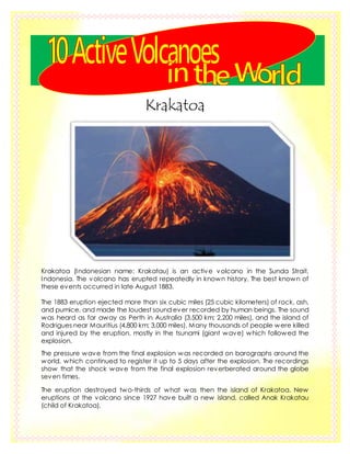
  • 1. Krakatoa Krakatoa (Indonesian name: Krakatau) is an active volcano in the Sunda Strait, Indonesia. The volcano has erupted repeatedly in known history. The best known of these events occurred in late August 1883. The 1883 eruption ejected more than six cubic miles (25 cubic kilometers) of rock, ash, and pumice, and made the loudest sound ever recorded by human beings. The sound was heard as far away as Perth in Australia (3,500 km; 2,200 miles), and the island of Rodrigues near Mauritius (4,800 km; 3,000 miles). Many thousands of people were killed and injured by the eruption, mostly in the tsunami (giant wave) which followed the explosion. The pressure wave from the final explosion was recorded on barographs around the world, which continued to register it up to 5 days after the explosion. The recordings show that the shock wave from the final explosion reverberated around the globe seven times. The eruption destroyed two-thirds of what was then the island of Krakatoa. New eruptions at the volcano since 1927 have built a new island, called Anak Krakatau (child of Krakatoa).
  • 2. Mayon Volcano The Mayon Volcano, also known as Mount Mayon, is an active volcano in the province of Albay, on Luzon island in the Philippines. It is a part of the Pacific Ring of Fire. It is one the most active and dangerous volcano in the Philippines. Mount Mayon is 2,642 metres (8,668 ft) high, and it is famous for it's "perfect cone" shape, which attracts tourists. In 1938 the mountain was declared a national park. It was reclassified and renamed as Mayon Volcano Natural Park in the year 2000. The name Mayon is from the Bicol word magayon meaning beauty. Mayon is the most active volcano in the Philippines having erupted ov er 49 times in the past 400 years. The first record of a major eruption was witnessed in February 1616 by Dutch explorer Joris van Spilbergen who recorded it on his log in his circumnavigation trip around the world.[8] The first eruption of which there is an extended account was the six-day event of July 20, 1766.
  • 3. Mauna Loa Volcano Located in the Hawaii islands, this is one of the five volcanoes that make up the Island of Hawaii in United States. This is the largest volcano in the world in terms of volume. It holds 18,000 cubic miles of magma and it is at a height of 120 feet above the sea level (which is usually lower compared to its peers). It was erupting for more than 700,000 years. The last volcanic eruption occurred in March 1984 and it lasted for more than 24 days causing heavy damage to the people and surrounding areas. Though they were not much explosive, the viscosity of their magma fluid will be very low. As the result, the movement of hot magma would be much faster compared to other volcanoes causing great destruction to the neighborhood areas.
  • 4. Popocatépetl Popocatépetl (also called El popo or Don Goyo) is an active volcano. The volcano is the second highest mountain in Mexico after Pico de Orizaba (5,610m). It is 5,426 m (17,802 ft) high. Popocatépetl is the Aztec word for "Smoking Mountain". Popocatépetl was an Aztec warrior who loved Iztaccíhuatl. Iztaccíhuatl's father sent Popocatepetl to war in Oaxaca. He promised him his daughter as his wife if he returned (which Iztaccíhuatl's father thought he would not). Iztaccíhuatl's father told her that her lover had died in battle. She died of sadness. When Popocatépetl returned, and found out about the death of his lover, he killed himself by stabbing a knife into his heart. The gods covered them with snow and changed them into mountains. Iztaccíhuatl's mountain was called "La Mujer Dormida, (the "Sleeping Woman"), because it looks like a woman sleeping on her back. Popocatépetl became the volcano Popocatépetl, raining fire on Earth in anger at the loss of his lover. Eruptions Popocatepetl has had more than 20 big eruptions since the arrival of the Spanish in 1519. A major eruption happened in 1947. On December 21, 1994 the volcano threw out gas and ash which was carried as far as 25 km away by the wind. This led to people having to leave nearby towns. Scientists began to check the volcano for an eruption. In December 2000, tens of thousands of people were made to leave the area by the government based on the warnings of scientists. The volcano then made its largest display in thousands of years.
  • 5. Mount St. Helens Mount St. Helens is a volcano in the U.S. state of Washington. It is 96 miles (154 km) south of Seattle and 53 miles (85 km) northeast of Portland, Oregon. The volcano is in Cascade Range of mountains. It is part of the Cascade Volcanic Arc in the Pacific Ring of Fire that includes over 160 activevolcanos. Mount St. Helens was first called Louwala- Clough, which means "smoking" or "fire mountain" in the language of the Native American Klickitat people. Modern eruptions Mount St. Helens erupted on May 18, 1980, at 08:32 a.m. Pacific Daylight Time. In the months before the large eruption that took place on May 18, 1980, there were many signs of volcanic activity. On March 20, 1980, Mount St. Helens was the center of a magnitude 4.2 earthquake. Steamventing fromthe volcano started on March 27. By the end of April, the north side of the volcano started to grow larger. On May 18, a second earthquake of magnitude 5.1 made a huge part of the north face of the volcano collapse. It was the largest known debris avalanche in recorded history. At 8:32 a.m. Pacific Daylight Time, the magma inside of St. Helens exploded. On the Volcanic Explosivity Index scale, the eruption was rated a five, which is the same rating of the famous Vesuvius eruption in 79 AD.
  • 6. Nevadodel Ruiz Nevadodel Ruiz, also called Mount Ruiz, is a volcano in Colombia. It is about 80 miles (129 km) west of Bogotá, close to the town of Armero. It is the highest active volcano in Colombia.There was a lahar after an eruption in 1985. About 23,000 people died when the lahar covered the Armero, making this the most deadly lahar in the history of the world. People who live near the volcano call it "the Sleeping Lion", because it was dormant or sleeping for nearly 150 years before the Armero lahar. On November 13, 1985, at 9:08 pm, Nevadodel Ruiz erupted; ejecting dacitic tephra more than 30 kilometers into the atmosphere. The amount of magma erupted from the volcano was 3% of that from Mount St. Helens in 1980. The eruption reached Volcanic Explosivity Index 3. The material ejected was described by scientists as "unusually rich in sulfur dioxide".Pyroclastic flows melted ice and snow at the summit, forming 4 thick lahars that rushed down several river valleys. As most lahars do, the mudflows began as flows of water, sand, and gravel, and mixed with clay along the way. The lahars were up to 50 meters thick and six feet deep and traveled more than 100 kilometers. The lahars destroyed many houses and towns. The town of Armero was completely covered by debris, killing approximately 21,000 people (three-fourths of the population), as well as affecting 13 other villages. The eruption caused an estimated 23,000 deaths, 5,000 injuries, and destroyed more than 5,000 homes. This was the second deadliest volcanic disaster in the 20th century, ousted only by the 1902 eruption of Mount Pelee, and the fourth deadliest eruption in recorded history. In addition, it was the deadliest lahar in recorded history, and Colombia's worst natural disaster.
  • 7. Mount Redoubt Redoubt Volcano, or Mount Redoubt, is an active stratovolcano in the largely volcanic Aleutian Range of the U.S. state of Alaska. Located at the head of the Chigmit Mountains subrange in Lake Clark National Park and Preserve, the mountain is just west of Cook Inlet, in the Kenai Peninsula Borough about 180 km (110 mi) southwest of Anchorage. At 10,197 feet, in just over 5 miles (8 km) Mount Redoubt attains 9,150 feet (2,700 m) of prominence over its surrounding terrain. It is the highest summit in the Aleutian Range. On March 22, 2009, Mount Redoubt erupted, sending ash high in the air and covering the mountains around with ash. No people live near Mount Redoubt, but the ash spread into towns and cities and the airport of Anchorage was closed shortly. Other years when it erupted include 1902, 1922, 1966, and 1989. On January 30, 2009, scientists from the Alaska Volcano Observatory (AVO) warned that an eruption was imminent, sending experienced Alaskans shopping for protection against a dusty shower of volcanic ash that could descend on south-central Alaska. By January 31, volcanic earthquakes increased to several per hour,[22] and a large hole in the glacier on the side of the mountain was spotted.[23] Scientists began to monitor seismic data from the mountain twenty-four hours a day in an effort to warn people in nearby communities.[24] A flyover conducted by the AVO detected "significant steaming from a new melt depression at the mouth of the summit crater near the vent area of the 1989-90 eruption."
  • 8. Taal Volcano Taal Volcano is a complex volcanolocated on the island of Luzon in the Philippines. It is the second most active volcano in the Philippines with 33 historical eruptions. All of these eruptions are concentrated on Volcano Island, an island near the middle of Taal Lake. The lake partially fills Taal Caldera, which was formed by prehistoric eruptions between 140,000 and 5,380 BP. Viewed from Tagaytay Ridge, Taal Volcano and Lake presents one of the most picturesque and attractive views in the Philippines. It is located about 50 km (31 mi) south of the capital of the country, the city of Manila. The volcano had several violent eruptions in the past causing loss of life in the island and the populated areas surrounding the lake, with the death toll estimated at around 5,000 to 6,000. Because of its proximity to populated areas and its eruptive history, the volcano was designated a Decade Volcano, worthy of close study to prevent future natural disasters. All volcanoes of the Philippines are part of the Pacific Ring of Fire.
  • 9. Mount Etna Mount Etna is an volcano on the east coast of Sicily, part of southern Italy. It is the largest active volcano in Europe. Mount Etna erupts every few years. Etna's most destructive eruption started on 11 March 1669. It produced lava flows that destroyed 10 villages and reached the town of Catania five weeks later, on 15 April. Many building were destroyed but it killed only a few people. Other major twentieth century eruptions occurred in 1949, 1971, 1983 and 1992, as well as the 2001 eruption. In 1971, it buried the Etna Observatory (built in the late 19th century) under lava. The 1992 eruption saw the town of Zafferana threatened by a lava flow, but successful diversion effortssaved the town with the loss of only one building a few hundred metres outside it. In 2002–2003, the biggest series of eruptions for many years threw up a huge column of ash that could easily be seen from space and fell as far away as Libya, on the far side of the Mediterranean Sea. Seismic activity in this eruption caused the eastern flanks of the volcanoto slip by up to two metres, and many houses on the flanks of the volcano got structural damage. The eruption also completely destroyed the RifugioSapienza, on the southern flank of the volcano.
  • 10. Mount Tambora Mount Tambora (8°14’41”S, 117°59’35”E) is an active volcano in Indonesia. It is also the tallest mountain in Indonesia. When the volcano erupted in 1815, it climaxed on 10 April. It was the most destructive volcanic eruption in modern history. It has been estimated that it was four times larger than the 1883 eruption of Krakatoa, between Java and Sumatra, in terms of volume of magma ejected. Before the explosion, Tambora was 4,300 m (14,100 ft) high, now it is only 2,722 m (8,930 ft) high. Its massive crater is therefore a caldera. The eruption destroyed a small Asian culture, known to archaeologists as the Tamboran kingdom. Most deaths from the eruption were from starvation and disease, as the fallout ruined farming in the local region. The death toll was at least 71,000 people,[5] of whom11,000–12,000 were killed directly by the eruption. The often-cited figure of 92,000 people killed is believed to be overestimated. It launched 160 cubic kilometers – 160 km3 (38 cu mi) – of ash into the upper atmosphere. This caused famine around the world. Tambora's 1815 outburst was the largest volcanic eruption in recorded history. The explosion was heard on Sumatra
  • 11. island more than 2,000 km (1,200 mi) away. Heavy volcanic ash falls were observed as far away as Borneo, Sulawesi, Java and Maluku islands.