Downloaded 16 times
![International Journal of Computer Applications Technology and Research
Volume 4– Issue 4, 242 - 247, 2015, ISSN:- 2319–8656
www.ijcat.com 243
that investigating officers have access to up to date information
from any location where there is a computer. This can only be
achieved through the use of crime mapping information systems
and geographic information system (GIS). Using questionnaire
and qualitative data from the Nigeria police, the objectives of this
study include 1) To identify the socio-economic factor
responsible for crime, 2) To determine the spatial distribution of
Crime type based on relevant data from Police stations. 3) To
capture and display the location of police stations and crime
hotspots using global positioning system (GPS)
A GIS is a system of hardware and software used for the
storage, retrieval, mapping and analysis of geographical data. It
is a tool for revealing what is otherwise invisible in geographical
information [3]. GIS assisted crime mapping is often
employed to understand the geographical distribution of
crime, identify crime concentrated area, or hot spots, and
facilitate deployment decisions regarding the duration and
dosage of intervention programs[4]. The early applications of
GIS in policing can be traced back to the 1960s, when it was
constrained by the limitation of older computer systems lacking
memory and speed [5]. The migration of GIS from mainframe
to desktop computers provides the law enforcing agencies
with a cost effective option for crime control since hardware
and software prices have reduced drastically. Methods of data
collection available to law enforcement agents include street
investigations, informers and undercover operations. GIS
would enhance the analysis of the collected data due to its ability
to handle spatial data[6].
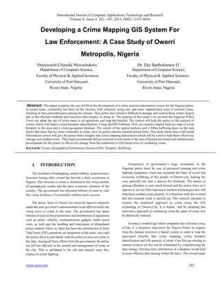
2. STUDY AREA
Owerri is the capital of Imo State in Nigeria, set in the heart
of the Igbo land and is located within Coordinates: 5.485 °N
North of Equator and longitude 7.035°E East of the meridian.
Owerri consists of three Local Government Areas namely Owerri
Municipal, Owerri North and Owerri West, it has an estimated
population of about 400,000 (NPC 2006) and is approximately
40 square miles (100 km2
) in area. The Owerri Slogan
is Heartland. It is currently referred to as the entertainment
capital of Nigeria and is home to an annual beauty pageant called
"Miss Heartland". There are five higher institution of learning in
the city namely Federal University of Technology, Federal
Polytechnic Nekede, Imo state Polytechnic Umuagwo, Alvan
Ikoku Federal College of Education and Imo state University
Owerri. Figure 1 shows the map of Owerri city
Figure 1 Map of Owerri municipal
3. CONCEPTUAL FRAMEWORK
A crime is an act against a person (for example, murder and
sexual assault), or his/her property (for example, theft and
property damage) and regulation (for example, traffic violations.
Crime is a human phenomenon; therefore it occurs in a place and
at a particular time. Crime analysis is important because it helps
to identify the different geographic patterns in criminal behavior.
Crime mapping is a procedure using GIS to conduct spatial
analysis of crime problems and police-related issues [1]. Crime
mapping is a sub discipline of crime analysis which has three
main functions. The first one is to facilitate visual and statistical
analysis to unravel the spatial nature of crime. The second one is
to provide a link to unlikely data sources on common geographic
variables and the last one is to produce maps that help to
communicate for analysis results [1].A geographic information
system integrates hardware, software, and data for capturing,
managing, analyzing, and displaying all forms of geographically
referenced information [7]. Use of GIS in police departments has
proliferated over the past decade. Crime mapping capabilities are
useful for police officers patrolling neighborhoods and
investigators trying to solve cases. They can view the recent
crime pattern of a neighborhood and query a GIS to search for](https://image.slidesharecdn.com/ijcatr04041006-150330040821-conversion-gate01/85/Developing-a-Crime-Mapping-GIS-System-For-Law-Enforcement-A-Case-Study-of-Owerri-Metropolis-Nigeria-2-320.jpg)
![International Journal of Computer Applications Technology and Research
Volume 4– Issue 4, 242 - 247, 2015, ISSN:- 2319–8656
www.ijcat.com 244
particular types of crime patterns, such as the location of all
recent burglaries within a mile radius of a given intersection[8].
Crime mapping implementation is relatively low in Nigeria.
However, numerous examples exist in the developed world eg
MAPS (Map-based Analytical Policing System) developed by
Rick McKee of the new Zealand police department in the year
2000 to assist his police colleagues in tackling crime. MAPS was
predominantly built for and used by Police intelligence analysts
to assist in identifying crime patterns and trends, it allowed basic
mapping queries to be compiled with a wizard-based formula that
could be conducted by all operational police staff. MAPS allow
users to build a query, select, display and explore crimes for any
location in New Zealand [2]
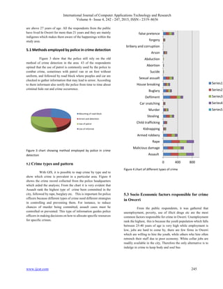
4. METHODOLOGY AND DATA
Two types of methods were adopted in this study. The first
method is the collection of data using questionnaires. Owerri
Municipal has 17 wards of which 8 wards were selected
randomly and 15 questions were distributed to each. A list of
Police stations in Owerri municipal was also collected from the
Police State Criminal investigation department. Ten (10) Police
stations were sampled and 2 questions were distributed to each
giving us a total of 140 respondents; this is to enable all police
stations in the study area to be part of the information gathering
and for accuracy purpose. The second method is a step by step
process (Figure 2) of how GIS can be employed in the creation
and analysis of Crime maps.
4.1 Spatial data used in this study include;
a) GPS coordinates of crime hotspots in Owerri City
b) GPS Coordinates of police stations in the study
area
c) land use and road map of Owerri municipal gotten
from Ministry of lands and survey,
New-Owerri secretariat, Owerri.
4.1.1 Attribute data include;
Records of types of crime
Attributes of police stations in the study area
Attribute of crime hotspot
Figure 2 flow chart of GIS map preparation and analysis
5. RESULTS AND ANALYSIS
This study assessed the spatial distribution of crime in
Owerri municipal. Data gotten from field work and other
relevant sources were analyzed to answer the objective of the
study. 140 questioners were distributed, 90% of the respondents
Conversion of analog map of
various Ward to digital format
ScaWard map
Georeferencing using ArcGIS
10.0
Digitization of map using ArcGIS
New
Land use Crime
hotspot GPS
Composite map of Station
GIS analysis
Creation of Charts based on questionnaire
Overla
Conclusion and Recommendation
GPS Coordinate of Police
station
Start
Composite map of hotspots
Sto](https://image.slidesharecdn.com/ijcatr04041006-150330040821-conversion-gate01/85/Developing-a-Crime-Mapping-GIS-System-For-Law-Enforcement-A-Case-Study-of-Owerri-Metropolis-Nigeria-3-320.jpg)
![International Journal of Computer Applications Technology and Research
Volume 4– Issue 4, 242 - 247, 2015, ISSN:- 2319–8656
www.ijcat.com 247
6. CONCLUSIONS
Based on the response from the field survey, it was
gathered that the Police force has heard of geographic
Information System but are yet to incorporate it into their daily
routine, this was very evident from my visit to the state
headquarter of police in the city of Owerri. There were few
computer system and no single global positioning system (GPS)
Tools seen anywhere in all the offices not to talk about the
various divisions, all method of handling data were done
manually, that is the reason why combating of crime has
remained traditional over the years without improvement. There
is need therefore to incorporate geographic information system
tools into their structure for better performance. More so, crime
hotspots are far from Police stations this is the reason why pattern
can be predicted and some areas experience repeat victimization.
Furthermore from the statistics of crime gathered assault, rape
and robbery are the highest in the city. This is as a result of
Institutional and commercial land use of which the youth are
mostly involved, this is due to unavailability of jobs and as the
adage goes an idle mind is the devils workshop. The solution to
all these increasing problem lies in the hand of the government
and various recommendations has been proffered below
6.1 Recommendations
The government should establish GIS/ICT sections in
all the police quarters and procure all the needed tools, and
annually train the police force on GIS usefulness in crime
detection and how to use the various tools. Police stations should
be cited in areas close to crime hotspot. A map of all the hotspots
and photographs of suspects should be stored in GIS tools to
increase the knowledge of the police in GIS and aid planners in
decision making. More so the police force should have a website
where citizens can easily alert them on crime scene, suspect and
their photographs at will and an accurate GPS coordinates of all
roads network should be stored in the GIS tools in order to
provide routine instruction to direct patrol vans to crime scene.
The use of GIS can assist the police to improve their traditional
method by acquiring information on land use and the socio-
economic factors that affects crime. Finally, government should
make drastic effort to create jobs by empowering the youths who
are more associated with crime from time to time.
7. REFERENCES
[1] Boba .R (2005). Role of GIS in the
institutionalization of analysis in police departments,
Corrections Technology center rocky mountain
division pre-conference workshops, Department of
Justice, Sage publication Inc Washington, U.S.A.
[2] Andy G. and Barclay J. (2007). Developing
geographical information systems and
crime mapping tools in New Zealand, Crime Mapping
Case Studies: Practice and Research, John Wiley &
Sons, Ltd, California, U.S.A.
[3] Longley, Goodchild .M, Maguire .D and Rhind .D
(2005). Geographical Information Systems and
Science, Wiley, West Sussex: John Wiley and Sons
Ltd, California, U.S.A.
[4] Yunus F. (2006) .web based multi participant spatial
data entry in crime mapping, Msc Thesis, Middle East
Technical University, Department of Geodetic and
Geographic Information Technologies, pp 1-31,
Ankara, Turkey.
[5] Weisburd, Bernasco .D, Bruinsma .W (2009). Putting
Crime in its Place: Units of Analysis in Geographic
Criminology. New York: Springer, U.S.A.
[6] Mukumbira S. (2012). Development of a Crime
Mapping, Analysis and PredictionTool for Windhoek,
Msc Thesis, Polytechnic of Namibia, School Of
Information Technology, Department Of Software
Engineering, 1 – 41, Namibia.
[7] Escobar, F., Hunter, G., Bishop, I., Zerger, A.:
Introduction to GIS. http://www.sli.unimelb.edu.au
(2014)
[8] Karen U, Kenneth W, and Vivaswan V. (2003). Crime
mapping applications for hawaii’s Juvenile justice
information system, Department of Urban and
Regional Planning University of Hawaii at Mānoa](https://image.slidesharecdn.com/ijcatr04041006-150330040821-conversion-gate01/85/Developing-a-Crime-Mapping-GIS-System-For-Law-Enforcement-A-Case-Study-of-Owerri-Metropolis-Nigeria-6-320.jpg)

This paper discusses the development of a Geographic Information System (GIS) for crime mapping to assist the Nigerian police in managing rising crime rates in Owerri. It highlights the inadequacies of traditional crime-fighting methods and suggests that GIS can improve crime analysis and hotspot identification. The study emphasizes the need for government support in equipping the police with modern technology to effectively combat crime.


