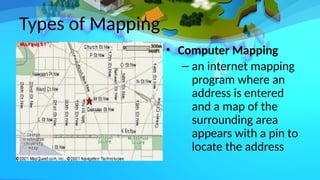
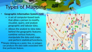
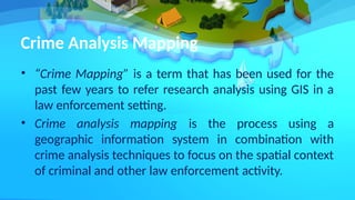
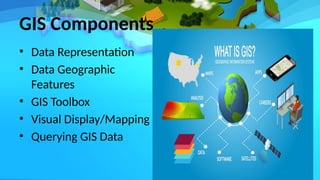
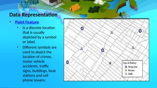
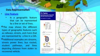
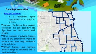
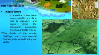
Crim 306: Types of Crime Mapping
Roxanne M. Pascua
Crime Mapping
• Often associated with the simple display and
querying of crime data using a Geographic
Information System (GIS)
• A general term that encompasses the technical
aspects of visualization and statistical techniques, as
well as practical aspects of geographic principles and
criminological theories.
Crime Mapping
• A progressive blend of practical criminal justice issues with the
research field of geographical information systems and science.
• Exploits the inherent geographical quality of crime
– Where do offenders live?
– Where are the most vulnerable communities/targets located?
– How do offenders travel to the crime location?
– Why do crimes occur in one area and not another?
– Where are our emerging problem areas?
From a TECHNICAL standpoint
• Crime Mapping is:
– A combination of visualization and statistical
techniques manifested as software.
– This combination is shared between mapping,
spatial analysis and spatial data analysis.
• Mapping is simply a visualization tool that is
used to display raw data and output from
analysis which is done through a GIS
History of Crime Mapping
• Early 1800s social theorists began to create maps to
illustrate their theories and research about crime
(Social Theorists: Single Symbol Point and Graduated
Maps).
– Maps initially were used to examine issues like
poverty or demographic characteristics and crime.
• New York City (1900s) (Single Symbol Point Maps, “pin
maps”
– One of the first police departments to use mapping.
– Simple wall maps using push pins to indicate crimes
occurred.
History of Crime Mapping
• During the 1920s and 1930s (Graduated Area
Maps of Crime and Delinquency)
– Sociologists at the University of Chicago used
mapping to examine crime and delinquency,
specifically juvenile delinquency and related
social characteristics.
• In 1960s and 1970s
– The first computer-generated maps of crime
were created.
History of Crime Mapping
• In 1980s
– Desktop computers were available for
mapping, but with limited quality.
• In 1990s
– Desktop geographic information systems
(GIS) became widely available
• In the late 1990s
– GIS began to generally used by law
enforcement agencies and criminologists.
Types of Mapping
• Manual Pin Mapping
– Large maps tacked to the
wall of the briefing room
with the most recent
crimes represented by
pins.
Do not have the data
associated with the features
and are not easily manipulated
compared to GIS.
Types of Mapping
• Computer Mapping
– an internet mapping
program where an
address is entered
and a map of the
surrounding area
appears with a pin to
locate the address
Types of Mapping
• Geographic Information System (GIS)
– A set of computer-based tools
that allow a person to modify,
visualize, query, and analyze
geographic and tabular data.
– Allows the analyst to view data
behind the geographic features,
combine various features,
manipulate the data and maps,
and perform statistical functions.
Simply clicking on a point, line, or polygon
can produce the data table associated with
that particular feature.
Crime Analysis Mapping
• “Crime Mapping” is a term that has been used for the
past few years to refer research analysis using GIS in a
law enforcement setting.
• Crime analysis mapping is the process using a
geographic information system in combination with
crime analysis techniques to focus on the spatial context
of criminal and other law enforcement activity.
GIS Components
• Data Representation
• Data Geographic
Features
• GIS Toolbox
• Visual Display/Mapping
• Querying GIS Data
Data Representation
• Point Feature
• Is a discrete location
that is usually
depicted by a symbol
or label.
• Different symbols are
used to depict the
location of crimes,
motor vehicle
accidents, traffic
signs, buildings, beat
stations and cell
phone towers.
Data Representation
• Line Feature
• Is a geographic feature
that can be represented
by a line or set of lines.
The map shows the different
types of geographic features such
as railways, streets, and rivers that
are represented by a line in a GIS.
Additional examples are streams,
streets power lines, bus routed,
student pathways, and lines
depicting distance from stolen to
recovered vehicle.
Data Representation
• Polygon Feature
• Is a multisided figure
represented by a closed set
of lines.
example,: the largest blue polygon
represents the city boundary, the
light blue are the census block
groups.
Other examples of polygon features
used in law enforcement would be
patrol areas, beats, neighbourhoods,
or jurisdictions.
Polygon features can represent
areas as large as continents and as
small as buildings.
Data Representation
• Image Feature
• Is a vertical photo taken
from a satellite or a plane
that is digitalized and
placed within the
geographic information
system coordinate system.
The details of the streets,
buildings, and environmental
features such as landscaping are
visible.
Data Geographic Features
– Each type of feature has “attributes” or a table of
data that describe it. These attributes are stored in
a GIS as a data table for analysis.
• Point Data
• Line data
• Polygon data
“Crime mapping supports many forms of
operational, tactical, investigative and strategic
policing and crime reduction activity”.
GIS Toolbox
 The primary advantage of a GIS is its
functionality that allows geographic data to
be manipulated. The following are some
components that enable data to be
manipulated.
• Connectivity
• Contiguity
• Geometry
GIS Toolbox
• Connectivity- refers to streets and other linear features
that are represented by segments that connect at
intersections.
• Data are associated with each line feature. However, each
segment connects at an intersection, and connectivity is
the ability of the GIS to recognize that the two line
segments come together to form an intersection.
• Thus, connectivity allows intersections to be located on the
map which is particularly important in law enforcement
data since information (reports and calls for service) usually
list an intersection as the location of an accident.
GIS Toolbox
• Contiguity- refers to adjacent
areas that are represented by
adjacent polygons.
 The map shows how a GIS includes
adjacent polygons representing
parcels and buildings.
 The ability of the GIS to recognize
adjacent polygons allows for
querying, selection of polygons
within others, and visualization of
complex land units.
GIS Toolbox
• Geometry- refers to the fact that all
features in the geographic information
system have at least one set of –x and –y
coordinates.
Visual display/mapping
• Thematic approach
• Scale
Querying GIS data
• Tabular queries
• Spatial queries

Reporting Different-Types-of-Crime-Mapping.pptx

  • 1.
    Crim 306: Typesof Crime Mapping Roxanne M. Pascua
  • 2.
    Crime Mapping • Oftenassociated with the simple display and querying of crime data using a Geographic Information System (GIS) • A general term that encompasses the technical aspects of visualization and statistical techniques, as well as practical aspects of geographic principles and criminological theories.
  • 3.
    Crime Mapping • Aprogressive blend of practical criminal justice issues with the research field of geographical information systems and science. • Exploits the inherent geographical quality of crime – Where do offenders live? – Where are the most vulnerable communities/targets located? – How do offenders travel to the crime location? – Why do crimes occur in one area and not another? – Where are our emerging problem areas?
  • 4.
    From a TECHNICALstandpoint • Crime Mapping is: – A combination of visualization and statistical techniques manifested as software. – This combination is shared between mapping, spatial analysis and spatial data analysis. • Mapping is simply a visualization tool that is used to display raw data and output from analysis which is done through a GIS
  • 5.
    History of CrimeMapping • Early 1800s social theorists began to create maps to illustrate their theories and research about crime (Social Theorists: Single Symbol Point and Graduated Maps). – Maps initially were used to examine issues like poverty or demographic characteristics and crime. • New York City (1900s) (Single Symbol Point Maps, “pin maps” – One of the first police departments to use mapping. – Simple wall maps using push pins to indicate crimes occurred.
  • 6.
    History of CrimeMapping • During the 1920s and 1930s (Graduated Area Maps of Crime and Delinquency) – Sociologists at the University of Chicago used mapping to examine crime and delinquency, specifically juvenile delinquency and related social characteristics. • In 1960s and 1970s – The first computer-generated maps of crime were created.
  • 7.
    History of CrimeMapping • In 1980s – Desktop computers were available for mapping, but with limited quality. • In 1990s – Desktop geographic information systems (GIS) became widely available • In the late 1990s – GIS began to generally used by law enforcement agencies and criminologists.
  • 8.
    Types of Mapping •Manual Pin Mapping – Large maps tacked to the wall of the briefing room with the most recent crimes represented by pins. Do not have the data associated with the features and are not easily manipulated compared to GIS.
  • 9.
    Types of Mapping •Computer Mapping – an internet mapping program where an address is entered and a map of the surrounding area appears with a pin to locate the address
  • 10.
    Types of Mapping •Geographic Information System (GIS) – A set of computer-based tools that allow a person to modify, visualize, query, and analyze geographic and tabular data. – Allows the analyst to view data behind the geographic features, combine various features, manipulate the data and maps, and perform statistical functions. Simply clicking on a point, line, or polygon can produce the data table associated with that particular feature.
  • 11.
    Crime Analysis Mapping •“Crime Mapping” is a term that has been used for the past few years to refer research analysis using GIS in a law enforcement setting. • Crime analysis mapping is the process using a geographic information system in combination with crime analysis techniques to focus on the spatial context of criminal and other law enforcement activity.
  • 12.
    GIS Components • DataRepresentation • Data Geographic Features • GIS Toolbox • Visual Display/Mapping • Querying GIS Data
  • 13.
    Data Representation • PointFeature • Is a discrete location that is usually depicted by a symbol or label. • Different symbols are used to depict the location of crimes, motor vehicle accidents, traffic signs, buildings, beat stations and cell phone towers.
  • 14.
    Data Representation • LineFeature • Is a geographic feature that can be represented by a line or set of lines. The map shows the different types of geographic features such as railways, streets, and rivers that are represented by a line in a GIS. Additional examples are streams, streets power lines, bus routed, student pathways, and lines depicting distance from stolen to recovered vehicle.
  • 15.
    Data Representation • PolygonFeature • Is a multisided figure represented by a closed set of lines. example,: the largest blue polygon represents the city boundary, the light blue are the census block groups. Other examples of polygon features used in law enforcement would be patrol areas, beats, neighbourhoods, or jurisdictions. Polygon features can represent areas as large as continents and as small as buildings.
  • 16.
    Data Representation • ImageFeature • Is a vertical photo taken from a satellite or a plane that is digitalized and placed within the geographic information system coordinate system. The details of the streets, buildings, and environmental features such as landscaping are visible.
  • 17.
    Data Geographic Features –Each type of feature has “attributes” or a table of data that describe it. These attributes are stored in a GIS as a data table for analysis. • Point Data • Line data • Polygon data
  • 18.
    “Crime mapping supportsmany forms of operational, tactical, investigative and strategic policing and crime reduction activity”.
  • 20.
    GIS Toolbox  Theprimary advantage of a GIS is its functionality that allows geographic data to be manipulated. The following are some components that enable data to be manipulated. • Connectivity • Contiguity • Geometry
  • 21.
    GIS Toolbox • Connectivity-refers to streets and other linear features that are represented by segments that connect at intersections. • Data are associated with each line feature. However, each segment connects at an intersection, and connectivity is the ability of the GIS to recognize that the two line segments come together to form an intersection. • Thus, connectivity allows intersections to be located on the map which is particularly important in law enforcement data since information (reports and calls for service) usually list an intersection as the location of an accident.
  • 22.
    GIS Toolbox • Contiguity-refers to adjacent areas that are represented by adjacent polygons.  The map shows how a GIS includes adjacent polygons representing parcels and buildings.  The ability of the GIS to recognize adjacent polygons allows for querying, selection of polygons within others, and visualization of complex land units.
  • 23.
    GIS Toolbox • Geometry-refers to the fact that all features in the geographic information system have at least one set of –x and –y coordinates.
  • 24.
  • 25.
    Querying GIS data •Tabular queries • Spatial queries