SlideShare a Scribd company logo
1 of 8
Download to read offline
Invention Journal of Research Technology in Engineering & Management (IJRTEM) ISSN: 2455-3689
www.ijrtem.com ǁ Volume 1 ǁ Issue 7 ǁ
| Volume 1 | Issue 7 | www.ijrtem.com | 33 |
Evaluate deficiencies and shortages for the Libyan Residential Urban
Planning. Case Study, Surman City, Libya using Arc (GIS) as technical tools
Farhat M Emhemed1
, Manal Mohsen Abood2
1, 2
(Faculty of Engineering and Technology Infrastructure, Infrastructure University Kuala Lumpur, (IUKL), Malaysia, 43000, Kuala
Lumpur)
ABSTRACT: The change in human society and the population increase in Surman citypopulation has led to an increase in
environmental problems and the increasing depletion of resources and natural resources and non-optimal use of land. This has led to
the disparity in the distribution of services, functions, lack of recreational areas, green areas, playgrounds, and other services.
Surman City scheme suffers from many problems, particularly the spread of housing projects. This has to be reconsidered in the ways
of development and the urban environment of the city planning. Sustainable urban planning is one of the most important ways and
strategies that can be followed for a diaper on Surman city scheme and preserves the rights of future generations to live in urban and
convenient style. The purpose of this research evaluation of residential areas Surman city scheme to know shortages and deficiencies
of the scheme of the city and their suitability for the planning of an urban sustainability using Arc (GIS) technology. It isimportant
means in the fields of life, especially the areas of sustainable urban planning where they can be utilized in the analysis and
conclusions, as well as future studies accurately and fast. The study found out that appropriate measurable indicators can be relied
upon to develop design criteria for residential that will help to achieve a sustainable urban plan during the preparation of urban
schemes or develop existing schemes.
Keywords: Evaluate residential urban planning,GIS, Sustainable urban planning, Residential urban planning.
Introduction
Increase and the rapid growth of population in the world is concentrated in urban cities, it is expected that by 2030 more than 60% of
the world's population will reside in urban areas(Nations, 2004). This requires the development of rapid urbanization and the
expansion of residential areas to the cities schemes and infrastructure development in the presence of population crawl and depletion
of natural resources and an optimal use of land (Hammer, Stewart, Winkler, Radeloff, & Voss, 2004). This has led to the development
of residential areas in many cases to have impact on open spaces and inequality in the distribution ratios for functions services which
impact on the style and dynamics and functions of urban areas and ecosystems for the development of residential areas(Irwin &
Bockstael, 2004). Sustainable urban planning has become an important element to achieve the principles of sustainability and the
ideal solution for residential and urban areas facing restriction by social-economic level, environmental pressure, population pressure
and traffic pressure, etc.(Xu & Coors, 2012) . Data and results on residential area development can thus be significantlyused to
understand the ways to raise the urban landscape change and help guide government agencies and planners in the optimal use of land
and ways of preserving the environment and natural resources and protection (Yin, Kong, & Zhang, 2011) .
The planning stage started first in Libya during the advent of Economic Development when it was preparing plans for the
development of important cities and villages in between (1968 - 1988). It focused on urban growth without addressing the regional
studies. There were two schemes established then, the first which was integrated detailed plans for major cities named overall
schemes. While the second type of schemes for cities and villages was named general schemes used to separate residential areas for
service activities. During the second year of the economic development (1969), it has prepared the first stage of it schemes because of
the improved economic situation of the country and the significant increase in the population growth and the development of
communities (Sheibani & Havard, 2005). By the end of the seventies, it has initiated planning in the second stage (1980 - 2000). The
stage included the preparation of a national plan, a long-term plan stage that included the preparation of four(4) regional schemes,
eighteen(18) regional scheme subcategories, and the preparation and development of 240 schemes for other cities. This stage was
based on a comprehensive and detailed foundations of the planning system adopted by all the regions. At the end of the second stage
of planning, Urban Planning Department began the preparation of the third planning stage, which was named third generation
schemes and the set time period for this stage was (2000-2025) (Libya, 2010).
Urban planning criteria are one the most important means of the preparation and implementation of urban plans and considered to be
the guidance or directory to help in the preparation of programs and development of schemes and the development of communities
through housing development and facilities and infrastructure. It also helps in the NEEDs assessment of land for the purpose of
providing services with acceptable criteria in the long term and to maintain the land (studies, 2000).
It is important to note that the failure to achieve the principles of sustainability in the built environment in Surman city scheme will
lead to the wasting of natural resources and making it difficult to create an eco-friendly environment. The result of the research was
presented to a converted access to set measurable indicators for Surman city special scheme for sustainable Urban Planning and to
measure their suitability with the aid of an Arc (GIS) technology to serve as a criterion. It measures the appropriateness of any future
project sustainability concept to be implemented within the planned city. It also recognizes the reality of Surman city scheme and the
Evaluate deficiencies and shortages for the Libyan Residential Urban Planning. Case Study, Surman City, Libya using.....
| Volume 1 | Issue 7 | www.ijrtem.com | 34 |
problems associated with planning in the city, and then apply the scheme and compared. The research built on finding out how to
apply sustainability criteria using geographic information systems (Alahamm, 2011) .
The purpose of this paper is to develop a sustainability analysis of urban residential development mainly considering andevaluatingthe
deficiencies and shortages of Surman city in Libya and to improve the scheme of the city in a residential domain of the traditional
scheme of an urban sustainable scheme. This research adopted the methodology of scientific research, gathering information, and
guides that have to do with Surman city plan and sustainable urban planning. It also adopted description and analysis using
geographic information systems (GIS). This research pointed out indicators that can be relied upon to develop the design of the
residential plan, and assist on sustainability in the preparation of development plans of existing criteria. The existing plans were done
with the aid of Geographic Information Systems (GIS) technology, which has the ability to analyze areas and schemes cities and give
accurate results at high speed. It is as a result of this that the researcher evaluated Surman city plan and ways to achieve sustainable
urban planning strategies. Furthermore, the research results obtained in empirical models were applied to provide important
sustainable insights into the urban residential development in recent years.
Method
2.1. Background of Surman City and city scheme (study area)
The area of study was located within Surman city scheme limits, which is located in the northwest in Libya, and about 60 km away
west of the capital Tripoli, and Coordinates. N 32° 45′ 24″, E 12°34'18''. The city has boundary from the north with the Mediterranean
Sea, to the east is Zawia city, to the south is Yafran city, and to the west of the city is Sabratha city shown in Figure. 1.The scheme is
located within the master plan for Surman city limits with an estimated total area of about 12,797,118 m2
(Office of Housing and
Utilities for Surman city, 2013). The total number of housing units is (2690), these are for two generations of the city for the schemes
which have been accredited in 1983. It accommodates a city planfor about (40,000) number of people, and the city relies on two types
of housing, the private housing and the public housing.The public housing in the form of different types of housing complexes
dispersed within the scheme (HUSCO,2012).
Figure. 1 Location of the study area
Source: HUSCO, 2012
2.2. The components of a city scheme
First: residential areas.
Residential areas consist of two types of buildings which are:
1- Separate Residential Buildings
It includes residential units located within the city scheme different floors and spaces spread sites.
- Residential buildings that consist of 4 floors, and contains two apartments on the floor, with a total of 1000 housing units, and a
housing unit area of 150.00 m2
.
- Residential Buildings that consists of 4 floors, and contains two apartments on the floor, with a total of 320 housing units, and a
housing unit area of 145.00 m2
.
Evaluate deficiencies and shortages for the Libyan Residential Urban Planning. Case Study, Surman City, Libya using.....
| Volume 1 | Issue 7 | www.ijrtem.com | 35 |
- Residential Buildings that consist of 4 floors, and contains two apartments on the floor, with a total of 920 housing units, and a
housing unit area of 145.00 m2
.
- Residential Buildings that consist of 5 floors, and contains two apartments on the floor, with a total of 100 housing units, and a
housing unit area of 140.00 m2
.
- Residential Buildings that consist of 3 floors, and contains two apartments on the floor, with a total of 150 housing units, and a
housing unit area of 138.00 m2
.
2- Buildings, Residential towers.
This includes three residential buildings next to some of the housing units that consists of 4 floors, in each of the floor there are 10
residential units, with a total of 200 housing units, and a housing unit area of 125.00 m2
(HUSCO,2012).
Second: public utilities and service facilities
- Services and Facilities:this includes urban complex, shopping mall, commercial buildings, police station, post office, cultural center,
shopping buildings of different types and three bank branches.
- Educational services includes: the 11 schools which are distributed within and around residential areas, and also includes a high-
Institute for Comprehensive professions.
- Health services: There are three health centers distributed Within the Plan.
- Religious services: There are four mosques distributed Within the Planed city, and two centers for the memorization of the Koran.
- Infrastructure: this includes roads, sidewalks, water systems, sewage, electricity, telephone network.
- The green areas: Contains a city planner on main public park brokered a city planner and small gardens within and around the
residential area.
The following table shows the components of residential areas and facilities located within the city plan and completion percentages
as shown in table (1)(Planning council management, 2012).
Table 1: The components of the residential areas of Surman city scheme.
Implementation rateNot completedCompletedNumberThe items
Residential areas
76%75240315Separate Residential
Building
100%033Contiguous Residential
Building
Services and Facilities
20%101Urban complex
100%011Shopping mall
100%02121Commercial buildings
100%011Police station
100%011Post office
100%011Cultural center
67%246Shopping buildings
100%033Bank branches
Educational services
64%4711Schools
Health services
33%213Health centers
Religious services
75%134Mosques
50%112Teaching the Koran
centers
Infrastructure
45%Roads, Sidewalks
55%Water systems
40%Sewage
70%Electricity
50%Telephone network
The green area
40%Main public park
30%Small gardens within and
Evaluate deficiencies and shortages for the Libyan Residential Urban Planning. Case Study, Surman City, Libya using.....
| Volume 1 | Issue 7 | www.ijrtem.com | 36 |
around the residential area
Results and Discussion
3.1 Surman city scheme and measurement indicators
In calculating the measurable indicators, dealing with city planners for what has been completed and implemented, and in the future
what are to be considered to evaluate the use of geographic information systems Arc(GIS).
3.1.1 Measuring diversity index of residential units
To measure the diversity of the housing unit index, one must know the number of housing units existing for residential in the city, and
then compared with other similar projects which have either of these projects locally or internationally.
Therefore, the establishment of these types of housing units within the city should be planned to fit the needs of a certain segment of
the population which are the low-income category. When comparing patterns and other types of housing units in other projects, it
should be taken into account the proportionality and diversity of the population category mentioned above.
Table 2 shows the type of housing units that is expected to be available in similar projects for Surman city, compared with what
remains of the housing units within the city plan (Farhat & Manal 2016).
Table 2: Types of housing units within Surman city scheme and the proportion achieve measurement index. Source: (Farhat& Manal,
2016).
AchievedNumber
available
Not
available
AvailableTape of housing units
NoNo found/80 m2
Tape of
area m2
NoNo found/100-120 m2
Yes2690/120-150 m2
Yes2490/An apartment in a
residential building
Apartment
tape
Yes200/Apartment in the tower
NoNo found/Separate villa - a
separate house
NoNo found/Any other kinds of
apartments. Studios…..
etc.
42.86%The total percentage to achieve diversity of the housing units index
3.1.2 Measuring the achievement of land use and environmental diversity index
This indicator can be measured by examining the private spaces for each activity within the residential areas, and also through the
study of land use in areas within the city plan. It then analyzes and draws conclusions in the percentage of each activity, after which
the rates of land use is compared to global case studies that have been mentioned to determine the proportion of similarity and
compatibility between them.
Tables 3: shows the area ratios and all land uses and functions in residential areas of the scheme city. Source: (Farhat & Manal, 2016
Percentage (%)Area (m2)Land used type
8.6865128149.8462Residential Buildings
0.20473020.0171Residential towers
1.732625560.1120The urban center
22.8743337458.7708Main streets
10.8118159502.9610Street services
13.5508199911.2506Corridors
10.7537158646.9086Car parks
Evaluate deficiencies and shortages for the Libyan Residential Urban Planning. Case Study, Surman City, Libya using.....
| Volume 1 | Issue 7 | www.ijrtem.com | 37 |
3.719254868.7308Public gardens
13.4105197841.0908Green areas
9.8959145992.0761Paved areas
0.62039151.2826Commercial center
0.26353888.0770Administrative buildings
0.16422422.0000Playgrounds
2.619538648.5866Schools
0.50017378.0733Health services
Banks
0.07051041.1516Cultural services
0.0380560.8700Civil defense
0.08331230.2687Police station
100.00001475272.0738The total
The table below shows the percentage use of land in Surman city scheme and comparable percentages of use of land per Masdar City
in United Arab Emirates and Dongtan city in China.
Table 4: Shows the comparison of each of the UAE Masdar City, Dongtan city in China with Surman city planner proportion of use of
land and residential areas.
Source: (Frenchman & Zegras, 2012),(Raza, Janajreh, & Ghenai, 2014), (HUSCO,2012).
Percentage achieves
rapprochement
Average
percentage of
Masdar City
and Dongtan
The
percentage
Land use
Surman
city
planned
Dongtan, ChinaMasdar
City,
UAE
96.21%
41.50%39.93%45.00%38.00%
Housing &
Residency,
open
spaces, and
services
184.09%
31.50%57.99%31.00%32.00%
Roads and
Corridors
9.96%
27.00%2.69%24.00%30.00%
Education
and
Scientific
Research
96.75%The total percentage to achieve land use index
3.1.3 Measurement of movement by private vehicles and pedestrians index
The possibility of measuring the mobility index should be focused on known residential areas which have a link with activities and
services such as daily movement (i.e. Schools, public parks, health clinics, mosques, commercial buildings, administrative buildings,
Evaluate deficiencies and shortages for the Libyan Residential Urban Planning. Case Study, Surman City, Libya using.....
| Volume 1 | Issue 7 | www.ijrtem.com | 38 |
banks, Cultural centers and Playgrounds). These services are to be located near residential areas, where the city population movement
relies on private vehicles or walking.
To achieve sustainability, the distance should not exceed 250m. The location of services near residential areas, circles within a radius
of 250 m, from which to determine the distance that has been covered and consistent with sustainable urban plan. After that is
determined, the number of residential buildings and places of covered services and daily activities that are meant to calculate the
percentage check on its own index. The percentage of the entire residential buildings is then determined to the extent of movement
and then measures the percentage index of the distribution. Table 5 shows the percentage of covered services and everyday activities
of residential buildings, to know the total proportion of residential buildings plan for the city.
Table 5 shows the percentage covered basic services for residential buildings in residential areas and measure the extent to which the
movement index.
Source: (Farhat & Manal, 2016).
Total
housin
g units
covere
d from
2690
units
Percentag
e of
Buildings
,
Residenti
al towers
(%)
Percentag
e of
Separate
Residenti
al
Buildings
(%)
Number
of
Buildings
,
Residenti
al towers
covered
by the
area of
the
service
Number of
Separate
Residentia
l Buildings
covered by
the area of
the service
Total
number
of
Building
s
Resident
ial
towers
(200
unit)
Total
number
of
Separate
Residenti
al
Buildings
(2490
unit)
Services
130010044.673141Schools
179210063.173199Public parks
200100030Health
clinics
00000Mosques
81610024.443773315Commercial
buildings
15007.93025Administrati
ve buildings
00000Banks
45610010.15332Cultural
centers
384015.23048Playgrounds
566 unitsThe average number of the housing units covered by the service basis
55.55%18.39%Percentage for each type of building
36.97%Percentage of each building and residential covered services
basic
3.1.4 Measuring the achievement of mixed land use index (Mixed Land use Factor)
The measurement using this indicator is to know and identify the green space percentage of the entire space used in the scheme, and
to see areas that give the possibility of bio-diversity emergence and continuity. It also focused on knowing places percentage for
linking rainwater into the soil and also taking into account the planned waste by the presence of methods or mechanisms for recycling
of waste. The network for collection of rainwater was also considered, and the network separated from the sewage network if it
exists.Table 6 shows the percentage of verification measuring biodiversity and green infrastructure of residential areas in the scheme.
Table 6: Shows the extent to which the biodiversity index measuring green infrastructure and residential areas in Surman city scheme.
Source: (Farhat & Manal, 2016).
Percentage
verification
(%)
Percentage ideal if
available
not
available
Available
Types of biodiversity
and green
infrastructure
44.70
Percentage
accounted for 30%
of the land used
Available as a
percentage 13.41%
of the land area
Green spaces
Evaluate deficiencies and shortages for the Libyan Residential Urban Planning. Case Study, Surman City, Libya using.....
| Volume 1 | Issue 7 | www.ijrtem.com | 39 |
used
45.00
Fair distribution
over the entire areas
used
Yes by about 45%
percentage spread
in some locations
Trees
0/Rainwater drainage
network (separate)
0/Processing and
recycling of waste
34.00Full executrix areasAvailable as a
percentage 34.00%
Rainwater leak of
surfaces
24.74%Percentage full achieved biodiversity and green infrastructure index
It was recorded that the extent to which the quality of the design housing criteria within the city scheme and their suitability to achieve
the principles of sustainability are met, depends on the use of measurable indicators. This was calculated and analyzed by using
geographic information systems Arc (GIS) which calculated the percentages of factor existing in the study area and compared it to the
rates of global idealism analysis.
It is observed that spacing in residential neighborhoods within the city near the scheme do not take into account the basic service
functions. This includes the lack of full coverage of basic services in residential areas for basic services and the movement index
achieved 36.97%. The percentage can be justified by trying to reconcile the requirements of the population in the surrounding areas
and the planned scheme. More also, it lacks a city plan and residential areas of biodiversity and green infrastructure. According to
green infrastructure and biodiversity index, a measure of the proportion of 24.74% is achieved. The city scheme also lacks the
diversity of the housing units where there are only two models of separate residential buildings and residential compounds, as well as
the convergence of housing units. This is achieved by the diversity of the housing units by 43% index. Whereas with regard to land
use, it was different percentages between functions since there are high percentages and other law, this is what has been achieved as a
measure of the land use index.
Conclusion
Surman city is a big city in land mass and has a population of about 70,000 people inside and outside of the planned city, of which
only 40,000 people are living Within the Planned Area. The planned area of the city is about 12,797,118 m2
. Surman city has
witnessed a major urban expansion and an increase in population growth in the last thirty years. This has led to the housing projects
inside and outside the scheme. But the lack of housing projects carried out within the planed area to the design criteria to keep up with
the basics sustainable urban plan is sophisticated and flexible.
The change in human society and the population increase in Surman city population has led to an increase in environmental problems
and the increasing depletion of resources and natural resources and non-optimal use of land. This has led to the disparity in the
distribution of services and functions and a lack of recreational areas, green areas, playgrounds, and other services. It is imperative to
rationalize the optimal use of land and how to use urban ways and ways to improve the environment and to serve the people.
Surman City scheme suffers from many problems, particularly the spread of housing projects, and that there are some of the design
criteria such as determining the site has not taken into account in accordance with the urban expansion, or development of old
neighborhood sites. More also, the non-application of the concepts of sustainability deviation to achieverebalance in the scheme of the
city. This has to be reconsidered in the ways of development and the urban environment of the city planning.
Sustainable urban planning is one of the most important ways and strategies that can be followed for a better Surman city scheme
which will preserves the rights of future generations to live in urban and convenient manner. Modern technology has become an
important means in the fields of life, especially the areas of sustainable urban planning, where they can be utilized in the analysis
and conclusions, as well as future studies accurately and faster.
Several residential areas have achieved global concepts of sustainable development through advanced urban communities and
preserve the ecological balance. An example of such places are the Lloyd Crossing countries- Portland district, Masdar City-the
United Arab Emirates and Dongtan city- China. Where these cities achieved the concepts and principles of urban planning and
sustainable through the application of several criteria and measurable indicators, the study focused on four of these indicators.These
are the diversity of the housing unit index, the index measuring the achievement of land use, the index measuring the achievement of
green infrastructure and bio-diversity and mobility by private vehicles, and pedestrian measurement index.
The analysis of Surman city scheme for housing which is the case study used for this research, shows that the city scheme can
applythese measurement indicators through the use of geographic information systems Arc (GIS) technology. This research has raise
and contributed to the knowledge of the city to help of researchers and developers in their studies. The study contribute to help
organizations and government institutions through the use of indicators used in this research.
Evaluate deficiencies and shortages for the Libyan Residential Urban Planning. Case Study, Surman City, Libya using.....
| Volume 1 | Issue 7 | www.ijrtem.com | 40 |
REFERENCE
1. Farhat. M. E& Manal. M. Abood. (2016). Development of the Design Criteria for the Libyan Residential Urban Planning. Case Study,
Surman City, Libya. IUKL INTERNATIONAL POSTGRAD COLLOQUIA (IIPC 2016) 27-28 JULY 2016. http://iipconf2016.iukl.edu.my
2. Alahamm, N. R. (2011). Toward creating new areas of Distinct and sustainable cities in Egypt
3. Critical vision for planning new cities. Information and Decision support center, No (24).
4. Frenchman, D., & Zegras, C. (2012). Making the Clean Energy City in China: Year 2 Report. Cambridge, Massachusetts :Massachusets
Institute of Technology, Center for Advance Urbanism.scripts.mit.documents/MIT_Clean_Energy_City_Year_2_Report_web.pdf/edu
http://energyproforma
5. Hammer, R. B., Stewart, S. I., Winkler, R. L., Radeloff, V. C., & Voss, P. R. (2004). Characterizing dynamic spatial and temporal residential
density patterns from 1940–1990 across the North Central United States. Landscape and Urban Planning, 69(2), 183-199.
6. Irwin, E. G., & Bockstael, N. E. (2004). Land use externalities, open space preservation, and urban sprawl. Regional science and urban
economics, 34(6), 705-725.
7. Libya, M. o. U. P. f. (2010). The third stage of planning (third generation
8. Nations, U. (2004). Department of Economic and Social Affairs, Population Division. World urbanization prospects: The 2003 revision. New
York: United Nations.
9. Office of Housing and Utilities for Surman city, D. d. a. e. s. (2013). Evaluate residential for Surman city, Report No. 1.
10. Planning council management, S. O. (2012). Monitoring andevaluation of residential units scheme for Surman city, Report No. 2.
11. Raza, S. S., Janajreh, I., & Ghenai, C. (2014). Sustainability index approach as a selection criteria for energy storage system of an intermittent
renewable energy source. Applied Energy, 136, 909-920.
12. Sheibani, G., & Havard, T. (2005). The government role in housing in Libya during the period 1970–2000. Paper presented at the 21st
Annual ARCOM Conference Report No(2)..
13. Studies, C. a. o. s. o. r. a. l. (2000). Guide-Criteria-Urban-Planning
14. Xu, Z., & Coors, V. (2012). Combining system dynamics model, GIS and 3D visualization in sustainability assessment of urban residential
development. Building and Environment, 47, 272-287.
15. Yin, H., Kong, F., & Zhang, X. (2011). Changes of residential land density and spatial pattern from 1989 to 2004 in Jinan City, China.
Chinese Geographical Science, 21(5), 619-628.
16. Housing and Utilities Surman City Office, (HUSCO) (2012), "Evaluation of housing projects in Surman report".

More Related Content

What's hot

Master plan and land use
Master plan and land useMaster plan and land use
Master plan and land useShourya Puri
 
Strategies for metropolitan planning
Strategies for metropolitan planningStrategies for metropolitan planning
Strategies for metropolitan planningASRufai
 
Esci regulatory issues -inframanagement
Esci regulatory issues -inframanagementEsci regulatory issues -inframanagement
Esci regulatory issues -inframanagementSrinath Rao Bompalli
 
Plan preparation techniques
Plan preparation techniquesPlan preparation techniques
Plan preparation techniquesCoEP
 
Structural plan for bangalore
Structural plan for bangaloreStructural plan for bangalore
Structural plan for bangalorevidhya monisha
 
Presentation on developmental plan
Presentation on developmental  planPresentation on developmental  plan
Presentation on developmental planRajat Nainwal
 
Urban planning in india
Urban planning in indiaUrban planning in india
Urban planning in indiaRISHABH SHARMA
 
2 urban and spatial plannning and design
2 urban and spatial plannning and design2 urban and spatial plannning and design
2 urban and spatial plannning and designTatang Kurniawan
 
Master Plan & Delhi Master Plan
Master Plan & Delhi Master PlanMaster Plan & Delhi Master Plan
Master Plan & Delhi Master PlanSahil Kaundal
 
Overview - Bangalore Metropolitan Region
Overview - Bangalore Metropolitan RegionOverview - Bangalore Metropolitan Region
Overview - Bangalore Metropolitan RegionAman Kudesia
 
History of Planning in Bangladesh
History of Planning in BangladeshHistory of Planning in Bangladesh
History of Planning in BangladeshShafinul Islam
 
ALL YOU DIDN'T KNOW ABOUT URBAN PLANNING
ALL YOU DIDN'T KNOW ABOUT URBAN PLANNINGALL YOU DIDN'T KNOW ABOUT URBAN PLANNING
ALL YOU DIDN'T KNOW ABOUT URBAN PLANNINGBlaise Nkubiyaho
 
Meaning and Need of Urban Planning
Meaning and Need of Urban Planning Meaning and Need of Urban Planning
Meaning and Need of Urban Planning Ravi Varma reddy
 
Land use planning
Land use planningLand use planning
Land use planningTin Lagman
 

What's hot (20)

Master plan and land use
Master plan and land useMaster plan and land use
Master plan and land use
 
Strategies for metropolitan planning
Strategies for metropolitan planningStrategies for metropolitan planning
Strategies for metropolitan planning
 
Esci regulatory issues -inframanagement
Esci regulatory issues -inframanagementEsci regulatory issues -inframanagement
Esci regulatory issues -inframanagement
 
Plan preparation techniques
Plan preparation techniquesPlan preparation techniques
Plan preparation techniques
 
Structural plan for bangalore
Structural plan for bangaloreStructural plan for bangalore
Structural plan for bangalore
 
Development Plan
Development PlanDevelopment Plan
Development Plan
 
Presentation on developmental plan
Presentation on developmental  planPresentation on developmental  plan
Presentation on developmental plan
 
spatial planning
spatial planning spatial planning
spatial planning
 
Urban planning in india
Urban planning in indiaUrban planning in india
Urban planning in india
 
2 urban and spatial plannning and design
2 urban and spatial plannning and design2 urban and spatial plannning and design
2 urban and spatial plannning and design
 
Master Plan & Delhi Master Plan
Master Plan & Delhi Master PlanMaster Plan & Delhi Master Plan
Master Plan & Delhi Master Plan
 
Presentation2
Presentation2Presentation2
Presentation2
 
Perspective plan
Perspective planPerspective plan
Perspective plan
 
Overview - Bangalore Metropolitan Region
Overview - Bangalore Metropolitan RegionOverview - Bangalore Metropolitan Region
Overview - Bangalore Metropolitan Region
 
History of Planning in Bangladesh
History of Planning in BangladeshHistory of Planning in Bangladesh
History of Planning in Bangladesh
 
Development Plan- Planning Intervention (CRITICAL ANALYSIS OF MASTER PLAN CA...
Development Plan- Planning Intervention (CRITICAL ANALYSIS OF MASTER PLAN  CA...Development Plan- Planning Intervention (CRITICAL ANALYSIS OF MASTER PLAN  CA...
Development Plan- Planning Intervention (CRITICAL ANALYSIS OF MASTER PLAN CA...
 
ALL YOU DIDN'T KNOW ABOUT URBAN PLANNING
ALL YOU DIDN'T KNOW ABOUT URBAN PLANNINGALL YOU DIDN'T KNOW ABOUT URBAN PLANNING
ALL YOU DIDN'T KNOW ABOUT URBAN PLANNING
 
Meaning and Need of Urban Planning
Meaning and Need of Urban Planning Meaning and Need of Urban Planning
Meaning and Need of Urban Planning
 
Land use planning
Land use planningLand use planning
Land use planning
 
URDPFI - 2016
URDPFI - 2016URDPFI - 2016
URDPFI - 2016
 

Similar to Evaluate deficiencies and shortages for the Libyan Residential Urban Planning. Case Study, Surman City, Libya using Arc (GIS) as technical tools

APPLICATION OF GIS FOR URBAN PLANNING amp MANAGEMENT.pdf
APPLICATION OF GIS FOR URBAN PLANNING  amp  MANAGEMENT.pdfAPPLICATION OF GIS FOR URBAN PLANNING  amp  MANAGEMENT.pdf
APPLICATION OF GIS FOR URBAN PLANNING amp MANAGEMENT.pdfWendy Belieu
 
ASSESSMENT OF URBAN DYNAMICS IN LAND USE AND DEMOGRPAHY USING GIS TECHNIQUES
ASSESSMENT OF URBAN DYNAMICS IN LAND USE AND DEMOGRPAHY USING GIS TECHNIQUESASSESSMENT OF URBAN DYNAMICS IN LAND USE AND DEMOGRPAHY USING GIS TECHNIQUES
ASSESSMENT OF URBAN DYNAMICS IN LAND USE AND DEMOGRPAHY USING GIS TECHNIQUESIRJET Journal
 
Multicriterial Analysis Applied to the Urban Environment of The Industrial Ar...
Multicriterial Analysis Applied to the Urban Environment of The Industrial Ar...Multicriterial Analysis Applied to the Urban Environment of The Industrial Ar...
Multicriterial Analysis Applied to the Urban Environment of The Industrial Ar...IJMERJOURNAL
 
Urban Planning Studio Project Orientation.pptx
Urban Planning Studio Project Orientation.pptxUrban Planning Studio Project Orientation.pptx
Urban Planning Studio Project Orientation.pptxtemesgen442110
 
Urban planning concept,principles and elementes
Urban planning  concept,principles and elementes Urban planning  concept,principles and elementes
Urban planning concept,principles and elementes TeshagerMengesha
 
Applications of RS and GIS in Urban Planning by Rakshith m murthy
Applications of RS and GIS in Urban Planning by Rakshith m murthyApplications of RS and GIS in Urban Planning by Rakshith m murthy
Applications of RS and GIS in Urban Planning by Rakshith m murthys0l0m0n7
 
Aed1313 ibe week 5 urp
Aed1313 ibe week 5 urpAed1313 ibe week 5 urp
Aed1313 ibe week 5 urpnurun2010
 
THE METHODS AND PRINCIPLES OF SETTLEMENTS DEVELOPMENT FOR ENERGY EFFICIENT LA...
THE METHODS AND PRINCIPLES OF SETTLEMENTS DEVELOPMENT FOR ENERGY EFFICIENT LA...THE METHODS AND PRINCIPLES OF SETTLEMENTS DEVELOPMENT FOR ENERGY EFFICIENT LA...
THE METHODS AND PRINCIPLES OF SETTLEMENTS DEVELOPMENT FOR ENERGY EFFICIENT LA...Rusmin R
 
Planning orientation through reference studies
Planning orientation through reference studiesPlanning orientation through reference studies
Planning orientation through reference studiesMohammad Shoeb Jafri
 
Redefining Master Plans to Promote Smart and Sustainable Cities
Redefining Master Plans to Promote Smart and Sustainable CitiesRedefining Master Plans to Promote Smart and Sustainable Cities
Redefining Master Plans to Promote Smart and Sustainable CitiesIRJET Journal
 
An Analysis of Urbanisation Dynamics with the Use of the Fuzzy Set Theory A C...
An Analysis of Urbanisation Dynamics with the Use of the Fuzzy Set Theory A C...An Analysis of Urbanisation Dynamics with the Use of the Fuzzy Set Theory A C...
An Analysis of Urbanisation Dynamics with the Use of the Fuzzy Set Theory A C...Fiona Phillips
 
Identification and Monitoring the Change of Land Use Pattern Using Remote Sen...
Identification and Monitoring the Change of Land Use Pattern Using Remote Sen...Identification and Monitoring the Change of Land Use Pattern Using Remote Sen...
Identification and Monitoring the Change of Land Use Pattern Using Remote Sen...IOSR Journals
 
Impact of Transportation System on Land Use in CBD area of Pabna Municipality...
Impact of Transportation System on Land Use in CBD area of Pabna Municipality...Impact of Transportation System on Land Use in CBD area of Pabna Municipality...
Impact of Transportation System on Land Use in CBD area of Pabna Municipality...Md. Merazul Islam Abir
 
Town planning - A Tool to Promote Holistic Development of Human settlements
Town planning - A Tool to Promote Holistic Development of Human settlementsTown planning - A Tool to Promote Holistic Development of Human settlements
Town planning - A Tool to Promote Holistic Development of Human settlementsJIT KUMAR GUPTA
 
Ubmps learning session_abe_en
Ubmps learning session_abe_enUbmps learning session_abe_en
Ubmps learning session_abe_enBayar Tsend
 

Similar to Evaluate deficiencies and shortages for the Libyan Residential Urban Planning. Case Study, Surman City, Libya using Arc (GIS) as technical tools (20)

APPLICATION OF GIS FOR URBAN PLANNING amp MANAGEMENT.pdf
APPLICATION OF GIS FOR URBAN PLANNING  amp  MANAGEMENT.pdfAPPLICATION OF GIS FOR URBAN PLANNING  amp  MANAGEMENT.pdf
APPLICATION OF GIS FOR URBAN PLANNING amp MANAGEMENT.pdf
 
ASSESSMENT OF URBAN DYNAMICS IN LAND USE AND DEMOGRPAHY USING GIS TECHNIQUES
ASSESSMENT OF URBAN DYNAMICS IN LAND USE AND DEMOGRPAHY USING GIS TECHNIQUESASSESSMENT OF URBAN DYNAMICS IN LAND USE AND DEMOGRPAHY USING GIS TECHNIQUES
ASSESSMENT OF URBAN DYNAMICS IN LAND USE AND DEMOGRPAHY USING GIS TECHNIQUES
 
Multicriterial Analysis Applied to the Urban Environment of The Industrial Ar...
Multicriterial Analysis Applied to the Urban Environment of The Industrial Ar...Multicriterial Analysis Applied to the Urban Environment of The Industrial Ar...
Multicriterial Analysis Applied to the Urban Environment of The Industrial Ar...
 
Urban Planning Studio Project Orientation.pptx
Urban Planning Studio Project Orientation.pptxUrban Planning Studio Project Orientation.pptx
Urban Planning Studio Project Orientation.pptx
 
Urban planning concept,principles and elementes
Urban planning  concept,principles and elementes Urban planning  concept,principles and elementes
Urban planning concept,principles and elementes
 
Applications of RS and GIS in Urban Planning by Rakshith m murthy
Applications of RS and GIS in Urban Planning by Rakshith m murthyApplications of RS and GIS in Urban Planning by Rakshith m murthy
Applications of RS and GIS in Urban Planning by Rakshith m murthy
 
Aed1313 ibe week 5 urp
Aed1313 ibe week 5 urpAed1313 ibe week 5 urp
Aed1313 ibe week 5 urp
 
THE METHODS AND PRINCIPLES OF SETTLEMENTS DEVELOPMENT FOR ENERGY EFFICIENT LA...
THE METHODS AND PRINCIPLES OF SETTLEMENTS DEVELOPMENT FOR ENERGY EFFICIENT LA...THE METHODS AND PRINCIPLES OF SETTLEMENTS DEVELOPMENT FOR ENERGY EFFICIENT LA...
THE METHODS AND PRINCIPLES OF SETTLEMENTS DEVELOPMENT FOR ENERGY EFFICIENT LA...
 
Planning orientation through reference studies
Planning orientation through reference studiesPlanning orientation through reference studies
Planning orientation through reference studies
 
PR Notes.pptx
PR Notes.pptxPR Notes.pptx
PR Notes.pptx
 
Redefining Master Plans to Promote Smart and Sustainable Cities
Redefining Master Plans to Promote Smart and Sustainable CitiesRedefining Master Plans to Promote Smart and Sustainable Cities
Redefining Master Plans to Promote Smart and Sustainable Cities
 
An Analysis of Urbanisation Dynamics with the Use of the Fuzzy Set Theory A C...
An Analysis of Urbanisation Dynamics with the Use of the Fuzzy Set Theory A C...An Analysis of Urbanisation Dynamics with the Use of the Fuzzy Set Theory A C...
An Analysis of Urbanisation Dynamics with the Use of the Fuzzy Set Theory A C...
 
Identification and Monitoring the Change of Land Use Pattern Using Remote Sen...
Identification and Monitoring the Change of Land Use Pattern Using Remote Sen...Identification and Monitoring the Change of Land Use Pattern Using Remote Sen...
Identification and Monitoring the Change of Land Use Pattern Using Remote Sen...
 
urdpfi ppt.pdf
urdpfi ppt.pdfurdpfi ppt.pdf
urdpfi ppt.pdf
 
Impact of Transportation System on Land Use in CBD area of Pabna Municipality...
Impact of Transportation System on Land Use in CBD area of Pabna Municipality...Impact of Transportation System on Land Use in CBD area of Pabna Municipality...
Impact of Transportation System on Land Use in CBD area of Pabna Municipality...
 
Town planning - A Tool to Promote Holistic Development of Human settlements
Town planning - A Tool to Promote Holistic Development of Human settlementsTown planning - A Tool to Promote Holistic Development of Human settlements
Town planning - A Tool to Promote Holistic Development of Human settlements
 
Town planning - A Tool to Promote Holistic Development of Human settlements
Town planning - A Tool to Promote Holistic Development of Human settlementsTown planning - A Tool to Promote Holistic Development of Human settlements
Town planning - A Tool to Promote Holistic Development of Human settlements
 
Eco2 Cities
Eco2 CitiesEco2 Cities
Eco2 Cities
 
Developing the Inhambane 2013 Land Use Plan- PEU 2013
Developing the Inhambane 2013 Land Use Plan- PEU 2013Developing the Inhambane 2013 Land Use Plan- PEU 2013
Developing the Inhambane 2013 Land Use Plan- PEU 2013
 
Ubmps learning session_abe_en
Ubmps learning session_abe_enUbmps learning session_abe_en
Ubmps learning session_abe_en
 

More from journal ijrtem

The effect of functionalized carbon nanotubes on thermalmechanical performanc...
The effect of functionalized carbon nanotubes on thermalmechanical performanc...The effect of functionalized carbon nanotubes on thermalmechanical performanc...
The effect of functionalized carbon nanotubes on thermalmechanical performanc...journal ijrtem
 
Development Issues and Problems of Selected Agency in Sorsogon, An investigat...
Development Issues and Problems of Selected Agency in Sorsogon, An investigat...Development Issues and Problems of Selected Agency in Sorsogon, An investigat...
Development Issues and Problems of Selected Agency in Sorsogon, An investigat...journal ijrtem
 
Positive and negative solutions of a boundary value problem for a fractional ...
Positive and negative solutions of a boundary value problem for a fractional ...Positive and negative solutions of a boundary value problem for a fractional ...
Positive and negative solutions of a boundary value problem for a fractional ...journal ijrtem
 
THE ESSENCE OF INDUSTRY 4.0
THE ESSENCE OF INDUSTRY 4.0THE ESSENCE OF INDUSTRY 4.0
THE ESSENCE OF INDUSTRY 4.0journal ijrtem
 
GREEN CHEMISTRY: A PRIMER
GREEN CHEMISTRY: A PRIMERGREEN CHEMISTRY: A PRIMER
GREEN CHEMISTRY: A PRIMERjournal ijrtem
 
Rural Livelihood and Food Security: Insights from Srilanka Tapu of Sunsari Di...
Rural Livelihood and Food Security: Insights from Srilanka Tapu of Sunsari Di...Rural Livelihood and Food Security: Insights from Srilanka Tapu of Sunsari Di...
Rural Livelihood and Food Security: Insights from Srilanka Tapu of Sunsari Di...journal ijrtem
 
Augmented Tourism: Definitions and Design Principles
Augmented Tourism: Definitions and Design PrinciplesAugmented Tourism: Definitions and Design Principles
Augmented Tourism: Definitions and Design Principlesjournal ijrtem
 
A study on financial aspect of supply chain management
A study on financial aspect of supply chain management	A study on financial aspect of supply chain management
A study on financial aspect of supply chain management journal ijrtem
 
Existence results for fractional q-differential equations with integral and m...
Existence results for fractional q-differential equations with integral and m...Existence results for fractional q-differential equations with integral and m...
Existence results for fractional q-differential equations with integral and m...journal ijrtem
 
Multi products storage using randomness
Multi products storage using randomnessMulti products storage using randomness
Multi products storage using randomnessjournal ijrtem
 
Study of desalination processes of seawater from the desalination plant of La...
Study of desalination processes of seawater from the desalination plant of La...Study of desalination processes of seawater from the desalination plant of La...
Study of desalination processes of seawater from the desalination plant of La...journal ijrtem
 
Effect of Cash Management on The Financial Performance of Cooperative Banks i...
Effect of Cash Management on The Financial Performance of Cooperative Banks i...Effect of Cash Management on The Financial Performance of Cooperative Banks i...
Effect of Cash Management on The Financial Performance of Cooperative Banks i...journal ijrtem
 
Technical expertise on the cause of engine failure of the Mitsubishi Pajero S...
Technical expertise on the cause of engine failure of the Mitsubishi Pajero S...Technical expertise on the cause of engine failure of the Mitsubishi Pajero S...
Technical expertise on the cause of engine failure of the Mitsubishi Pajero S...journal ijrtem
 
Clustering based Time Slot Assignment Protocol for Improving Performance in U...
Clustering based Time Slot Assignment Protocol for Improving Performance in U...Clustering based Time Slot Assignment Protocol for Improving Performance in U...
Clustering based Time Slot Assignment Protocol for Improving Performance in U...journal ijrtem
 
Design and Implementation of Smart Bell Notification System using IoT
Design and Implementation of Smart Bell Notification System using IoT	Design and Implementation of Smart Bell Notification System using IoT
Design and Implementation of Smart Bell Notification System using IoT journal ijrtem
 
Assessment of the Water Quality of Lake Sidi Boughaba (Ramsar Site 1980) Keni...
Assessment of the Water Quality of Lake Sidi Boughaba (Ramsar Site 1980) Keni...Assessment of the Water Quality of Lake Sidi Boughaba (Ramsar Site 1980) Keni...
Assessment of the Water Quality of Lake Sidi Boughaba (Ramsar Site 1980) Keni...journal ijrtem
 
The case of a cyclist and tractor traffic accident
The case of a cyclist and tractor traffic accident	The case of a cyclist and tractor traffic accident
The case of a cyclist and tractor traffic accident journal ijrtem
 
A Smart Approach for Traffic Management
A Smart Approach for Traffic Management	A Smart Approach for Traffic Management
A Smart Approach for Traffic Management journal ijrtem
 

More from journal ijrtem (20)

The effect of functionalized carbon nanotubes on thermalmechanical performanc...
The effect of functionalized carbon nanotubes on thermalmechanical performanc...The effect of functionalized carbon nanotubes on thermalmechanical performanc...
The effect of functionalized carbon nanotubes on thermalmechanical performanc...
 
Development Issues and Problems of Selected Agency in Sorsogon, An investigat...
Development Issues and Problems of Selected Agency in Sorsogon, An investigat...Development Issues and Problems of Selected Agency in Sorsogon, An investigat...
Development Issues and Problems of Selected Agency in Sorsogon, An investigat...
 
Positive and negative solutions of a boundary value problem for a fractional ...
Positive and negative solutions of a boundary value problem for a fractional ...Positive and negative solutions of a boundary value problem for a fractional ...
Positive and negative solutions of a boundary value problem for a fractional ...
 
ORGANIC FOODS
ORGANIC FOODSORGANIC FOODS
ORGANIC FOODS
 
MOLECULAR COMPUTING
MOLECULAR COMPUTINGMOLECULAR COMPUTING
MOLECULAR COMPUTING
 
THE ESSENCE OF INDUSTRY 4.0
THE ESSENCE OF INDUSTRY 4.0THE ESSENCE OF INDUSTRY 4.0
THE ESSENCE OF INDUSTRY 4.0
 
GREEN CHEMISTRY: A PRIMER
GREEN CHEMISTRY: A PRIMERGREEN CHEMISTRY: A PRIMER
GREEN CHEMISTRY: A PRIMER
 
Rural Livelihood and Food Security: Insights from Srilanka Tapu of Sunsari Di...
Rural Livelihood and Food Security: Insights from Srilanka Tapu of Sunsari Di...Rural Livelihood and Food Security: Insights from Srilanka Tapu of Sunsari Di...
Rural Livelihood and Food Security: Insights from Srilanka Tapu of Sunsari Di...
 
Augmented Tourism: Definitions and Design Principles
Augmented Tourism: Definitions and Design PrinciplesAugmented Tourism: Definitions and Design Principles
Augmented Tourism: Definitions and Design Principles
 
A study on financial aspect of supply chain management
A study on financial aspect of supply chain management	A study on financial aspect of supply chain management
A study on financial aspect of supply chain management
 
Existence results for fractional q-differential equations with integral and m...
Existence results for fractional q-differential equations with integral and m...Existence results for fractional q-differential equations with integral and m...
Existence results for fractional q-differential equations with integral and m...
 
Multi products storage using randomness
Multi products storage using randomnessMulti products storage using randomness
Multi products storage using randomness
 
Study of desalination processes of seawater from the desalination plant of La...
Study of desalination processes of seawater from the desalination plant of La...Study of desalination processes of seawater from the desalination plant of La...
Study of desalination processes of seawater from the desalination plant of La...
 
Effect of Cash Management on The Financial Performance of Cooperative Banks i...
Effect of Cash Management on The Financial Performance of Cooperative Banks i...Effect of Cash Management on The Financial Performance of Cooperative Banks i...
Effect of Cash Management on The Financial Performance of Cooperative Banks i...
 
Technical expertise on the cause of engine failure of the Mitsubishi Pajero S...
Technical expertise on the cause of engine failure of the Mitsubishi Pajero S...Technical expertise on the cause of engine failure of the Mitsubishi Pajero S...
Technical expertise on the cause of engine failure of the Mitsubishi Pajero S...
 
Clustering based Time Slot Assignment Protocol for Improving Performance in U...
Clustering based Time Slot Assignment Protocol for Improving Performance in U...Clustering based Time Slot Assignment Protocol for Improving Performance in U...
Clustering based Time Slot Assignment Protocol for Improving Performance in U...
 
Design and Implementation of Smart Bell Notification System using IoT
Design and Implementation of Smart Bell Notification System using IoT	Design and Implementation of Smart Bell Notification System using IoT
Design and Implementation of Smart Bell Notification System using IoT
 
Assessment of the Water Quality of Lake Sidi Boughaba (Ramsar Site 1980) Keni...
Assessment of the Water Quality of Lake Sidi Boughaba (Ramsar Site 1980) Keni...Assessment of the Water Quality of Lake Sidi Boughaba (Ramsar Site 1980) Keni...
Assessment of the Water Quality of Lake Sidi Boughaba (Ramsar Site 1980) Keni...
 
The case of a cyclist and tractor traffic accident
The case of a cyclist and tractor traffic accident	The case of a cyclist and tractor traffic accident
The case of a cyclist and tractor traffic accident
 
A Smart Approach for Traffic Management
A Smart Approach for Traffic Management	A Smart Approach for Traffic Management
A Smart Approach for Traffic Management
 

Recently uploaded

Software and Systems Engineering Standards: Verification and Validation of Sy...
Software and Systems Engineering Standards: Verification and Validation of Sy...Software and Systems Engineering Standards: Verification and Validation of Sy...
Software and Systems Engineering Standards: Verification and Validation of Sy...VICTOR MAESTRE RAMIREZ
 
HARMONY IN THE NATURE AND EXISTENCE - Unit-IV
HARMONY IN THE NATURE AND EXISTENCE - Unit-IVHARMONY IN THE NATURE AND EXISTENCE - Unit-IV
HARMONY IN THE NATURE AND EXISTENCE - Unit-IVRajaP95
 
Gurgaon ✡️9711147426✨Call In girls Gurgaon Sector 51 escort service
Gurgaon ✡️9711147426✨Call In girls Gurgaon Sector 51 escort serviceGurgaon ✡️9711147426✨Call In girls Gurgaon Sector 51 escort service
Gurgaon ✡️9711147426✨Call In girls Gurgaon Sector 51 escort servicejennyeacort
 
Heart Disease Prediction using machine learning.pptx
Heart Disease Prediction using machine learning.pptxHeart Disease Prediction using machine learning.pptx
Heart Disease Prediction using machine learning.pptxPoojaBan
 
ZXCTN 5804 / ZTE PTN / ZTE POTN / ZTE 5804 PTN / ZTE POTN 5804 ( 100/200 GE Z...
ZXCTN 5804 / ZTE PTN / ZTE POTN / ZTE 5804 PTN / ZTE POTN 5804 ( 100/200 GE Z...ZXCTN 5804 / ZTE PTN / ZTE POTN / ZTE 5804 PTN / ZTE POTN 5804 ( 100/200 GE Z...
ZXCTN 5804 / ZTE PTN / ZTE POTN / ZTE 5804 PTN / ZTE POTN 5804 ( 100/200 GE Z...ZTE
 
Oxy acetylene welding presentation note.
Oxy acetylene welding presentation note.Oxy acetylene welding presentation note.
Oxy acetylene welding presentation note.eptoze12
 
VIP Call Girls Service Hitech City Hyderabad Call +91-8250192130
VIP Call Girls Service Hitech City Hyderabad Call +91-8250192130VIP Call Girls Service Hitech City Hyderabad Call +91-8250192130
VIP Call Girls Service Hitech City Hyderabad Call +91-8250192130Suhani Kapoor
 
Call Girls Delhi {Jodhpur} 9711199012 high profile service
Call Girls Delhi {Jodhpur} 9711199012 high profile serviceCall Girls Delhi {Jodhpur} 9711199012 high profile service
Call Girls Delhi {Jodhpur} 9711199012 high profile servicerehmti665
 
CCS355 Neural Network & Deep Learning Unit II Notes with Question bank .pdf
CCS355 Neural Network & Deep Learning Unit II Notes with Question bank .pdfCCS355 Neural Network & Deep Learning Unit II Notes with Question bank .pdf
CCS355 Neural Network & Deep Learning Unit II Notes with Question bank .pdfAsst.prof M.Gokilavani
 
Introduction to Microprocesso programming and interfacing.pptx
Introduction to Microprocesso programming and interfacing.pptxIntroduction to Microprocesso programming and interfacing.pptx
Introduction to Microprocesso programming and interfacing.pptxvipinkmenon1
 
HARMONY IN THE HUMAN BEING - Unit-II UHV-2
HARMONY IN THE HUMAN BEING - Unit-II UHV-2HARMONY IN THE HUMAN BEING - Unit-II UHV-2
HARMONY IN THE HUMAN BEING - Unit-II UHV-2RajaP95
 
Internship report on mechanical engineering
Internship report on mechanical engineeringInternship report on mechanical engineering
Internship report on mechanical engineeringmalavadedarshan25
 
What are the advantages and disadvantages of membrane structures.pptx
What are the advantages and disadvantages of membrane structures.pptxWhat are the advantages and disadvantages of membrane structures.pptx
What are the advantages and disadvantages of membrane structures.pptxwendy cai
 
microprocessor 8085 and its interfacing
microprocessor 8085  and its interfacingmicroprocessor 8085  and its interfacing
microprocessor 8085 and its interfacingjaychoudhary37
 
Call Girls Narol 7397865700 Independent Call Girls
Call Girls Narol 7397865700 Independent Call GirlsCall Girls Narol 7397865700 Independent Call Girls
Call Girls Narol 7397865700 Independent Call Girlsssuser7cb4ff
 
GDSC ASEB Gen AI study jams presentation
GDSC ASEB Gen AI study jams presentationGDSC ASEB Gen AI study jams presentation
GDSC ASEB Gen AI study jams presentationGDSCAESB
 
(ANVI) Koregaon Park Call Girls Just Call 7001035870 [ Cash on Delivery ] Pun...
(ANVI) Koregaon Park Call Girls Just Call 7001035870 [ Cash on Delivery ] Pun...(ANVI) Koregaon Park Call Girls Just Call 7001035870 [ Cash on Delivery ] Pun...
(ANVI) Koregaon Park Call Girls Just Call 7001035870 [ Cash on Delivery ] Pun...ranjana rawat
 
Microscopic Analysis of Ceramic Materials.pptx
Microscopic Analysis of Ceramic Materials.pptxMicroscopic Analysis of Ceramic Materials.pptx
Microscopic Analysis of Ceramic Materials.pptxpurnimasatapathy1234
 

Recently uploaded (20)

Software and Systems Engineering Standards: Verification and Validation of Sy...
Software and Systems Engineering Standards: Verification and Validation of Sy...Software and Systems Engineering Standards: Verification and Validation of Sy...
Software and Systems Engineering Standards: Verification and Validation of Sy...
 
HARMONY IN THE NATURE AND EXISTENCE - Unit-IV
HARMONY IN THE NATURE AND EXISTENCE - Unit-IVHARMONY IN THE NATURE AND EXISTENCE - Unit-IV
HARMONY IN THE NATURE AND EXISTENCE - Unit-IV
 
Gurgaon ✡️9711147426✨Call In girls Gurgaon Sector 51 escort service
Gurgaon ✡️9711147426✨Call In girls Gurgaon Sector 51 escort serviceGurgaon ✡️9711147426✨Call In girls Gurgaon Sector 51 escort service
Gurgaon ✡️9711147426✨Call In girls Gurgaon Sector 51 escort service
 
Heart Disease Prediction using machine learning.pptx
Heart Disease Prediction using machine learning.pptxHeart Disease Prediction using machine learning.pptx
Heart Disease Prediction using machine learning.pptx
 
ZXCTN 5804 / ZTE PTN / ZTE POTN / ZTE 5804 PTN / ZTE POTN 5804 ( 100/200 GE Z...
ZXCTN 5804 / ZTE PTN / ZTE POTN / ZTE 5804 PTN / ZTE POTN 5804 ( 100/200 GE Z...ZXCTN 5804 / ZTE PTN / ZTE POTN / ZTE 5804 PTN / ZTE POTN 5804 ( 100/200 GE Z...
ZXCTN 5804 / ZTE PTN / ZTE POTN / ZTE 5804 PTN / ZTE POTN 5804 ( 100/200 GE Z...
 
Oxy acetylene welding presentation note.
Oxy acetylene welding presentation note.Oxy acetylene welding presentation note.
Oxy acetylene welding presentation note.
 
VIP Call Girls Service Hitech City Hyderabad Call +91-8250192130
VIP Call Girls Service Hitech City Hyderabad Call +91-8250192130VIP Call Girls Service Hitech City Hyderabad Call +91-8250192130
VIP Call Girls Service Hitech City Hyderabad Call +91-8250192130
 
🔝9953056974🔝!!-YOUNG call girls in Rajendra Nagar Escort rvice Shot 2000 nigh...
🔝9953056974🔝!!-YOUNG call girls in Rajendra Nagar Escort rvice Shot 2000 nigh...🔝9953056974🔝!!-YOUNG call girls in Rajendra Nagar Escort rvice Shot 2000 nigh...
🔝9953056974🔝!!-YOUNG call girls in Rajendra Nagar Escort rvice Shot 2000 nigh...
 
Call Girls Delhi {Jodhpur} 9711199012 high profile service
Call Girls Delhi {Jodhpur} 9711199012 high profile serviceCall Girls Delhi {Jodhpur} 9711199012 high profile service
Call Girls Delhi {Jodhpur} 9711199012 high profile service
 
CCS355 Neural Network & Deep Learning Unit II Notes with Question bank .pdf
CCS355 Neural Network & Deep Learning Unit II Notes with Question bank .pdfCCS355 Neural Network & Deep Learning Unit II Notes with Question bank .pdf
CCS355 Neural Network & Deep Learning Unit II Notes with Question bank .pdf
 
Introduction to Microprocesso programming and interfacing.pptx
Introduction to Microprocesso programming and interfacing.pptxIntroduction to Microprocesso programming and interfacing.pptx
Introduction to Microprocesso programming and interfacing.pptx
 
HARMONY IN THE HUMAN BEING - Unit-II UHV-2
HARMONY IN THE HUMAN BEING - Unit-II UHV-2HARMONY IN THE HUMAN BEING - Unit-II UHV-2
HARMONY IN THE HUMAN BEING - Unit-II UHV-2
 
Internship report on mechanical engineering
Internship report on mechanical engineeringInternship report on mechanical engineering
Internship report on mechanical engineering
 
What are the advantages and disadvantages of membrane structures.pptx
What are the advantages and disadvantages of membrane structures.pptxWhat are the advantages and disadvantages of membrane structures.pptx
What are the advantages and disadvantages of membrane structures.pptx
 
microprocessor 8085 and its interfacing
microprocessor 8085  and its interfacingmicroprocessor 8085  and its interfacing
microprocessor 8085 and its interfacing
 
Call Girls Narol 7397865700 Independent Call Girls
Call Girls Narol 7397865700 Independent Call GirlsCall Girls Narol 7397865700 Independent Call Girls
Call Girls Narol 7397865700 Independent Call Girls
 
GDSC ASEB Gen AI study jams presentation
GDSC ASEB Gen AI study jams presentationGDSC ASEB Gen AI study jams presentation
GDSC ASEB Gen AI study jams presentation
 
(ANVI) Koregaon Park Call Girls Just Call 7001035870 [ Cash on Delivery ] Pun...
(ANVI) Koregaon Park Call Girls Just Call 7001035870 [ Cash on Delivery ] Pun...(ANVI) Koregaon Park Call Girls Just Call 7001035870 [ Cash on Delivery ] Pun...
(ANVI) Koregaon Park Call Girls Just Call 7001035870 [ Cash on Delivery ] Pun...
 
young call girls in Rajiv Chowk🔝 9953056974 🔝 Delhi escort Service
young call girls in Rajiv Chowk🔝 9953056974 🔝 Delhi escort Serviceyoung call girls in Rajiv Chowk🔝 9953056974 🔝 Delhi escort Service
young call girls in Rajiv Chowk🔝 9953056974 🔝 Delhi escort Service
 
Microscopic Analysis of Ceramic Materials.pptx
Microscopic Analysis of Ceramic Materials.pptxMicroscopic Analysis of Ceramic Materials.pptx
Microscopic Analysis of Ceramic Materials.pptx
 

Evaluate deficiencies and shortages for the Libyan Residential Urban Planning. Case Study, Surman City, Libya using Arc (GIS) as technical tools

  • 1. Invention Journal of Research Technology in Engineering & Management (IJRTEM) ISSN: 2455-3689 www.ijrtem.com ǁ Volume 1 ǁ Issue 7 ǁ | Volume 1 | Issue 7 | www.ijrtem.com | 33 | Evaluate deficiencies and shortages for the Libyan Residential Urban Planning. Case Study, Surman City, Libya using Arc (GIS) as technical tools Farhat M Emhemed1 , Manal Mohsen Abood2 1, 2 (Faculty of Engineering and Technology Infrastructure, Infrastructure University Kuala Lumpur, (IUKL), Malaysia, 43000, Kuala Lumpur) ABSTRACT: The change in human society and the population increase in Surman citypopulation has led to an increase in environmental problems and the increasing depletion of resources and natural resources and non-optimal use of land. This has led to the disparity in the distribution of services, functions, lack of recreational areas, green areas, playgrounds, and other services. Surman City scheme suffers from many problems, particularly the spread of housing projects. This has to be reconsidered in the ways of development and the urban environment of the city planning. Sustainable urban planning is one of the most important ways and strategies that can be followed for a diaper on Surman city scheme and preserves the rights of future generations to live in urban and convenient style. The purpose of this research evaluation of residential areas Surman city scheme to know shortages and deficiencies of the scheme of the city and their suitability for the planning of an urban sustainability using Arc (GIS) technology. It isimportant means in the fields of life, especially the areas of sustainable urban planning where they can be utilized in the analysis and conclusions, as well as future studies accurately and fast. The study found out that appropriate measurable indicators can be relied upon to develop design criteria for residential that will help to achieve a sustainable urban plan during the preparation of urban schemes or develop existing schemes. Keywords: Evaluate residential urban planning,GIS, Sustainable urban planning, Residential urban planning. Introduction Increase and the rapid growth of population in the world is concentrated in urban cities, it is expected that by 2030 more than 60% of the world's population will reside in urban areas(Nations, 2004). This requires the development of rapid urbanization and the expansion of residential areas to the cities schemes and infrastructure development in the presence of population crawl and depletion of natural resources and an optimal use of land (Hammer, Stewart, Winkler, Radeloff, & Voss, 2004). This has led to the development of residential areas in many cases to have impact on open spaces and inequality in the distribution ratios for functions services which impact on the style and dynamics and functions of urban areas and ecosystems for the development of residential areas(Irwin & Bockstael, 2004). Sustainable urban planning has become an important element to achieve the principles of sustainability and the ideal solution for residential and urban areas facing restriction by social-economic level, environmental pressure, population pressure and traffic pressure, etc.(Xu & Coors, 2012) . Data and results on residential area development can thus be significantlyused to understand the ways to raise the urban landscape change and help guide government agencies and planners in the optimal use of land and ways of preserving the environment and natural resources and protection (Yin, Kong, & Zhang, 2011) . The planning stage started first in Libya during the advent of Economic Development when it was preparing plans for the development of important cities and villages in between (1968 - 1988). It focused on urban growth without addressing the regional studies. There were two schemes established then, the first which was integrated detailed plans for major cities named overall schemes. While the second type of schemes for cities and villages was named general schemes used to separate residential areas for service activities. During the second year of the economic development (1969), it has prepared the first stage of it schemes because of the improved economic situation of the country and the significant increase in the population growth and the development of communities (Sheibani & Havard, 2005). By the end of the seventies, it has initiated planning in the second stage (1980 - 2000). The stage included the preparation of a national plan, a long-term plan stage that included the preparation of four(4) regional schemes, eighteen(18) regional scheme subcategories, and the preparation and development of 240 schemes for other cities. This stage was based on a comprehensive and detailed foundations of the planning system adopted by all the regions. At the end of the second stage of planning, Urban Planning Department began the preparation of the third planning stage, which was named third generation schemes and the set time period for this stage was (2000-2025) (Libya, 2010). Urban planning criteria are one the most important means of the preparation and implementation of urban plans and considered to be the guidance or directory to help in the preparation of programs and development of schemes and the development of communities through housing development and facilities and infrastructure. It also helps in the NEEDs assessment of land for the purpose of providing services with acceptable criteria in the long term and to maintain the land (studies, 2000). It is important to note that the failure to achieve the principles of sustainability in the built environment in Surman city scheme will lead to the wasting of natural resources and making it difficult to create an eco-friendly environment. The result of the research was presented to a converted access to set measurable indicators for Surman city special scheme for sustainable Urban Planning and to measure their suitability with the aid of an Arc (GIS) technology to serve as a criterion. It measures the appropriateness of any future project sustainability concept to be implemented within the planned city. It also recognizes the reality of Surman city scheme and the
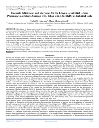
  • 2. Evaluate deficiencies and shortages for the Libyan Residential Urban Planning. Case Study, Surman City, Libya using..... | Volume 1 | Issue 7 | www.ijrtem.com | 34 | problems associated with planning in the city, and then apply the scheme and compared. The research built on finding out how to apply sustainability criteria using geographic information systems (Alahamm, 2011) . The purpose of this paper is to develop a sustainability analysis of urban residential development mainly considering andevaluatingthe deficiencies and shortages of Surman city in Libya and to improve the scheme of the city in a residential domain of the traditional scheme of an urban sustainable scheme. This research adopted the methodology of scientific research, gathering information, and guides that have to do with Surman city plan and sustainable urban planning. It also adopted description and analysis using geographic information systems (GIS). This research pointed out indicators that can be relied upon to develop the design of the residential plan, and assist on sustainability in the preparation of development plans of existing criteria. The existing plans were done with the aid of Geographic Information Systems (GIS) technology, which has the ability to analyze areas and schemes cities and give accurate results at high speed. It is as a result of this that the researcher evaluated Surman city plan and ways to achieve sustainable urban planning strategies. Furthermore, the research results obtained in empirical models were applied to provide important sustainable insights into the urban residential development in recent years. Method 2.1. Background of Surman City and city scheme (study area) The area of study was located within Surman city scheme limits, which is located in the northwest in Libya, and about 60 km away west of the capital Tripoli, and Coordinates. N 32° 45′ 24″, E 12°34'18''. The city has boundary from the north with the Mediterranean Sea, to the east is Zawia city, to the south is Yafran city, and to the west of the city is Sabratha city shown in Figure. 1.The scheme is located within the master plan for Surman city limits with an estimated total area of about 12,797,118 m2 (Office of Housing and Utilities for Surman city, 2013). The total number of housing units is (2690), these are for two generations of the city for the schemes which have been accredited in 1983. It accommodates a city planfor about (40,000) number of people, and the city relies on two types of housing, the private housing and the public housing.The public housing in the form of different types of housing complexes dispersed within the scheme (HUSCO,2012). Figure. 1 Location of the study area Source: HUSCO, 2012 2.2. The components of a city scheme First: residential areas. Residential areas consist of two types of buildings which are: 1- Separate Residential Buildings It includes residential units located within the city scheme different floors and spaces spread sites. - Residential buildings that consist of 4 floors, and contains two apartments on the floor, with a total of 1000 housing units, and a housing unit area of 150.00 m2 . - Residential Buildings that consists of 4 floors, and contains two apartments on the floor, with a total of 320 housing units, and a housing unit area of 145.00 m2 .
  • 3. Evaluate deficiencies and shortages for the Libyan Residential Urban Planning. Case Study, Surman City, Libya using..... | Volume 1 | Issue 7 | www.ijrtem.com | 35 | - Residential Buildings that consist of 4 floors, and contains two apartments on the floor, with a total of 920 housing units, and a housing unit area of 145.00 m2 . - Residential Buildings that consist of 5 floors, and contains two apartments on the floor, with a total of 100 housing units, and a housing unit area of 140.00 m2 . - Residential Buildings that consist of 3 floors, and contains two apartments on the floor, with a total of 150 housing units, and a housing unit area of 138.00 m2 . 2- Buildings, Residential towers. This includes three residential buildings next to some of the housing units that consists of 4 floors, in each of the floor there are 10 residential units, with a total of 200 housing units, and a housing unit area of 125.00 m2 (HUSCO,2012). Second: public utilities and service facilities - Services and Facilities:this includes urban complex, shopping mall, commercial buildings, police station, post office, cultural center, shopping buildings of different types and three bank branches. - Educational services includes: the 11 schools which are distributed within and around residential areas, and also includes a high- Institute for Comprehensive professions. - Health services: There are three health centers distributed Within the Plan. - Religious services: There are four mosques distributed Within the Planed city, and two centers for the memorization of the Koran. - Infrastructure: this includes roads, sidewalks, water systems, sewage, electricity, telephone network. - The green areas: Contains a city planner on main public park brokered a city planner and small gardens within and around the residential area. The following table shows the components of residential areas and facilities located within the city plan and completion percentages as shown in table (1)(Planning council management, 2012). Table 1: The components of the residential areas of Surman city scheme. Implementation rateNot completedCompletedNumberThe items Residential areas 76%75240315Separate Residential Building 100%033Contiguous Residential Building Services and Facilities 20%101Urban complex 100%011Shopping mall 100%02121Commercial buildings 100%011Police station 100%011Post office 100%011Cultural center 67%246Shopping buildings 100%033Bank branches Educational services 64%4711Schools Health services 33%213Health centers Religious services 75%134Mosques 50%112Teaching the Koran centers Infrastructure 45%Roads, Sidewalks 55%Water systems 40%Sewage 70%Electricity 50%Telephone network The green area 40%Main public park 30%Small gardens within and
  • 4. Evaluate deficiencies and shortages for the Libyan Residential Urban Planning. Case Study, Surman City, Libya using..... | Volume 1 | Issue 7 | www.ijrtem.com | 36 | around the residential area Results and Discussion 3.1 Surman city scheme and measurement indicators In calculating the measurable indicators, dealing with city planners for what has been completed and implemented, and in the future what are to be considered to evaluate the use of geographic information systems Arc(GIS). 3.1.1 Measuring diversity index of residential units To measure the diversity of the housing unit index, one must know the number of housing units existing for residential in the city, and then compared with other similar projects which have either of these projects locally or internationally. Therefore, the establishment of these types of housing units within the city should be planned to fit the needs of a certain segment of the population which are the low-income category. When comparing patterns and other types of housing units in other projects, it should be taken into account the proportionality and diversity of the population category mentioned above. Table 2 shows the type of housing units that is expected to be available in similar projects for Surman city, compared with what remains of the housing units within the city plan (Farhat & Manal 2016). Table 2: Types of housing units within Surman city scheme and the proportion achieve measurement index. Source: (Farhat& Manal, 2016). AchievedNumber available Not available AvailableTape of housing units NoNo found/80 m2 Tape of area m2 NoNo found/100-120 m2 Yes2690/120-150 m2 Yes2490/An apartment in a residential building Apartment tape Yes200/Apartment in the tower NoNo found/Separate villa - a separate house NoNo found/Any other kinds of apartments. Studios….. etc. 42.86%The total percentage to achieve diversity of the housing units index 3.1.2 Measuring the achievement of land use and environmental diversity index This indicator can be measured by examining the private spaces for each activity within the residential areas, and also through the study of land use in areas within the city plan. It then analyzes and draws conclusions in the percentage of each activity, after which the rates of land use is compared to global case studies that have been mentioned to determine the proportion of similarity and compatibility between them. Tables 3: shows the area ratios and all land uses and functions in residential areas of the scheme city. Source: (Farhat & Manal, 2016 Percentage (%)Area (m2)Land used type 8.6865128149.8462Residential Buildings 0.20473020.0171Residential towers 1.732625560.1120The urban center 22.8743337458.7708Main streets 10.8118159502.9610Street services 13.5508199911.2506Corridors 10.7537158646.9086Car parks
  • 5. Evaluate deficiencies and shortages for the Libyan Residential Urban Planning. Case Study, Surman City, Libya using..... | Volume 1 | Issue 7 | www.ijrtem.com | 37 | 3.719254868.7308Public gardens 13.4105197841.0908Green areas 9.8959145992.0761Paved areas 0.62039151.2826Commercial center 0.26353888.0770Administrative buildings 0.16422422.0000Playgrounds 2.619538648.5866Schools 0.50017378.0733Health services Banks 0.07051041.1516Cultural services 0.0380560.8700Civil defense 0.08331230.2687Police station 100.00001475272.0738The total The table below shows the percentage use of land in Surman city scheme and comparable percentages of use of land per Masdar City in United Arab Emirates and Dongtan city in China. Table 4: Shows the comparison of each of the UAE Masdar City, Dongtan city in China with Surman city planner proportion of use of land and residential areas. Source: (Frenchman & Zegras, 2012),(Raza, Janajreh, & Ghenai, 2014), (HUSCO,2012). Percentage achieves rapprochement Average percentage of Masdar City and Dongtan The percentage Land use Surman city planned Dongtan, ChinaMasdar City, UAE 96.21% 41.50%39.93%45.00%38.00% Housing & Residency, open spaces, and services 184.09% 31.50%57.99%31.00%32.00% Roads and Corridors 9.96% 27.00%2.69%24.00%30.00% Education and Scientific Research 96.75%The total percentage to achieve land use index 3.1.3 Measurement of movement by private vehicles and pedestrians index The possibility of measuring the mobility index should be focused on known residential areas which have a link with activities and services such as daily movement (i.e. Schools, public parks, health clinics, mosques, commercial buildings, administrative buildings,
  • 6. Evaluate deficiencies and shortages for the Libyan Residential Urban Planning. Case Study, Surman City, Libya using..... | Volume 1 | Issue 7 | www.ijrtem.com | 38 | banks, Cultural centers and Playgrounds). These services are to be located near residential areas, where the city population movement relies on private vehicles or walking. To achieve sustainability, the distance should not exceed 250m. The location of services near residential areas, circles within a radius of 250 m, from which to determine the distance that has been covered and consistent with sustainable urban plan. After that is determined, the number of residential buildings and places of covered services and daily activities that are meant to calculate the percentage check on its own index. The percentage of the entire residential buildings is then determined to the extent of movement and then measures the percentage index of the distribution. Table 5 shows the percentage of covered services and everyday activities of residential buildings, to know the total proportion of residential buildings plan for the city. Table 5 shows the percentage covered basic services for residential buildings in residential areas and measure the extent to which the movement index. Source: (Farhat & Manal, 2016). Total housin g units covere d from 2690 units Percentag e of Buildings , Residenti al towers (%) Percentag e of Separate Residenti al Buildings (%) Number of Buildings , Residenti al towers covered by the area of the service Number of Separate Residentia l Buildings covered by the area of the service Total number of Building s Resident ial towers (200 unit) Total number of Separate Residenti al Buildings (2490 unit) Services 130010044.673141Schools 179210063.173199Public parks 200100030Health clinics 00000Mosques 81610024.443773315Commercial buildings 15007.93025Administrati ve buildings 00000Banks 45610010.15332Cultural centers 384015.23048Playgrounds 566 unitsThe average number of the housing units covered by the service basis 55.55%18.39%Percentage for each type of building 36.97%Percentage of each building and residential covered services basic 3.1.4 Measuring the achievement of mixed land use index (Mixed Land use Factor) The measurement using this indicator is to know and identify the green space percentage of the entire space used in the scheme, and to see areas that give the possibility of bio-diversity emergence and continuity. It also focused on knowing places percentage for linking rainwater into the soil and also taking into account the planned waste by the presence of methods or mechanisms for recycling of waste. The network for collection of rainwater was also considered, and the network separated from the sewage network if it exists.Table 6 shows the percentage of verification measuring biodiversity and green infrastructure of residential areas in the scheme. Table 6: Shows the extent to which the biodiversity index measuring green infrastructure and residential areas in Surman city scheme. Source: (Farhat & Manal, 2016). Percentage verification (%) Percentage ideal if available not available Available Types of biodiversity and green infrastructure 44.70 Percentage accounted for 30% of the land used Available as a percentage 13.41% of the land area Green spaces
  • 7. Evaluate deficiencies and shortages for the Libyan Residential Urban Planning. Case Study, Surman City, Libya using..... | Volume 1 | Issue 7 | www.ijrtem.com | 39 | used 45.00 Fair distribution over the entire areas used Yes by about 45% percentage spread in some locations Trees 0/Rainwater drainage network (separate) 0/Processing and recycling of waste 34.00Full executrix areasAvailable as a percentage 34.00% Rainwater leak of surfaces 24.74%Percentage full achieved biodiversity and green infrastructure index It was recorded that the extent to which the quality of the design housing criteria within the city scheme and their suitability to achieve the principles of sustainability are met, depends on the use of measurable indicators. This was calculated and analyzed by using geographic information systems Arc (GIS) which calculated the percentages of factor existing in the study area and compared it to the rates of global idealism analysis. It is observed that spacing in residential neighborhoods within the city near the scheme do not take into account the basic service functions. This includes the lack of full coverage of basic services in residential areas for basic services and the movement index achieved 36.97%. The percentage can be justified by trying to reconcile the requirements of the population in the surrounding areas and the planned scheme. More also, it lacks a city plan and residential areas of biodiversity and green infrastructure. According to green infrastructure and biodiversity index, a measure of the proportion of 24.74% is achieved. The city scheme also lacks the diversity of the housing units where there are only two models of separate residential buildings and residential compounds, as well as the convergence of housing units. This is achieved by the diversity of the housing units by 43% index. Whereas with regard to land use, it was different percentages between functions since there are high percentages and other law, this is what has been achieved as a measure of the land use index. Conclusion Surman city is a big city in land mass and has a population of about 70,000 people inside and outside of the planned city, of which only 40,000 people are living Within the Planned Area. The planned area of the city is about 12,797,118 m2 . Surman city has witnessed a major urban expansion and an increase in population growth in the last thirty years. This has led to the housing projects inside and outside the scheme. But the lack of housing projects carried out within the planed area to the design criteria to keep up with the basics sustainable urban plan is sophisticated and flexible. The change in human society and the population increase in Surman city population has led to an increase in environmental problems and the increasing depletion of resources and natural resources and non-optimal use of land. This has led to the disparity in the distribution of services and functions and a lack of recreational areas, green areas, playgrounds, and other services. It is imperative to rationalize the optimal use of land and how to use urban ways and ways to improve the environment and to serve the people. Surman City scheme suffers from many problems, particularly the spread of housing projects, and that there are some of the design criteria such as determining the site has not taken into account in accordance with the urban expansion, or development of old neighborhood sites. More also, the non-application of the concepts of sustainability deviation to achieverebalance in the scheme of the city. This has to be reconsidered in the ways of development and the urban environment of the city planning. Sustainable urban planning is one of the most important ways and strategies that can be followed for a better Surman city scheme which will preserves the rights of future generations to live in urban and convenient manner. Modern technology has become an important means in the fields of life, especially the areas of sustainable urban planning, where they can be utilized in the analysis and conclusions, as well as future studies accurately and faster. Several residential areas have achieved global concepts of sustainable development through advanced urban communities and preserve the ecological balance. An example of such places are the Lloyd Crossing countries- Portland district, Masdar City-the United Arab Emirates and Dongtan city- China. Where these cities achieved the concepts and principles of urban planning and sustainable through the application of several criteria and measurable indicators, the study focused on four of these indicators.These are the diversity of the housing unit index, the index measuring the achievement of land use, the index measuring the achievement of green infrastructure and bio-diversity and mobility by private vehicles, and pedestrian measurement index. The analysis of Surman city scheme for housing which is the case study used for this research, shows that the city scheme can applythese measurement indicators through the use of geographic information systems Arc (GIS) technology. This research has raise and contributed to the knowledge of the city to help of researchers and developers in their studies. The study contribute to help organizations and government institutions through the use of indicators used in this research.
  • 8. Evaluate deficiencies and shortages for the Libyan Residential Urban Planning. Case Study, Surman City, Libya using..... | Volume 1 | Issue 7 | www.ijrtem.com | 40 | REFERENCE 1. Farhat. M. E& Manal. M. Abood. (2016). Development of the Design Criteria for the Libyan Residential Urban Planning. Case Study, Surman City, Libya. IUKL INTERNATIONAL POSTGRAD COLLOQUIA (IIPC 2016) 27-28 JULY 2016. http://iipconf2016.iukl.edu.my 2. Alahamm, N. R. (2011). Toward creating new areas of Distinct and sustainable cities in Egypt 3. Critical vision for planning new cities. Information and Decision support center, No (24). 4. Frenchman, D., & Zegras, C. (2012). Making the Clean Energy City in China: Year 2 Report. Cambridge, Massachusetts :Massachusets Institute of Technology, Center for Advance Urbanism.scripts.mit.documents/MIT_Clean_Energy_City_Year_2_Report_web.pdf/edu http://energyproforma 5. Hammer, R. B., Stewart, S. I., Winkler, R. L., Radeloff, V. C., & Voss, P. R. (2004). Characterizing dynamic spatial and temporal residential density patterns from 1940–1990 across the North Central United States. Landscape and Urban Planning, 69(2), 183-199. 6. Irwin, E. G., & Bockstael, N. E. (2004). Land use externalities, open space preservation, and urban sprawl. Regional science and urban economics, 34(6), 705-725. 7. Libya, M. o. U. P. f. (2010). The third stage of planning (third generation 8. Nations, U. (2004). Department of Economic and Social Affairs, Population Division. World urbanization prospects: The 2003 revision. New York: United Nations. 9. Office of Housing and Utilities for Surman city, D. d. a. e. s. (2013). Evaluate residential for Surman city, Report No. 1. 10. Planning council management, S. O. (2012). Monitoring andevaluation of residential units scheme for Surman city, Report No. 2. 11. Raza, S. S., Janajreh, I., & Ghenai, C. (2014). Sustainability index approach as a selection criteria for energy storage system of an intermittent renewable energy source. Applied Energy, 136, 909-920. 12. Sheibani, G., & Havard, T. (2005). The government role in housing in Libya during the period 1970–2000. Paper presented at the 21st Annual ARCOM Conference Report No(2).. 13. Studies, C. a. o. s. o. r. a. l. (2000). Guide-Criteria-Urban-Planning 14. Xu, Z., & Coors, V. (2012). Combining system dynamics model, GIS and 3D visualization in sustainability assessment of urban residential development. Building and Environment, 47, 272-287. 15. Yin, H., Kong, F., & Zhang, X. (2011). Changes of residential land density and spatial pattern from 1989 to 2004 in Jinan City, China. Chinese Geographical Science, 21(5), 619-628. 16. Housing and Utilities Surman City Office, (HUSCO) (2012), "Evaluation of housing projects in Surman report".