MuleSoft Integration with AWS Textract | Calling AWS Textract API |AWS - Clou...
Glaciers
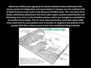
1. About two million years ago great ice sheets started to move southward, from
various centers of refrigeration and accumulation in Canada, over the northern half
of North America as far south as the Missouri and Ohio rivers. This vast sheet of ice
slowly, relentlessly, plowed over the Great Lakes region, pushed onward by the ever
thickening mass of ice on the Canadian plateau until it was brought to a standstill at
its southernmost margin. The ice never advanced farther south than about 1600
miles away from its accumulation zone in Canada, or roughly to the position of the
present Ohio River, whose course in part was established along its border
2. The glaciers advanced into the Great Lakes
region as a series of ice lobes, each lobe
seeking out the lowest preexisting spots on
the landscape. To the various glacial lobes we
have given the names of the Great Lakes and
bays which eventually occupied the enlarged
depressions after the ice had disappeared.