HUMANITIES 9 - NATURAL HAZARDS: WHITE ISLAND VOLCANIC ERUPTION
•Download as PPTX, PDF•
0 likes•245 views

HUMANITIES 9 - NATURAL HAZARDS: WHITE ISLAND VOLCANIC ERUPTION

Recommended
Recommended
More Related Content
What's hot
What's hot (20)
Similar to HUMANITIES 9 - NATURAL HAZARDS: WHITE ISLAND VOLCANIC ERUPTION
Similar to HUMANITIES 9 - NATURAL HAZARDS: WHITE ISLAND VOLCANIC ERUPTION (20)
More from George Dumitrache
More from George Dumitrache (20)
Recently uploaded
Recently uploaded (20)
HUMANITIES 9 - NATURAL HAZARDS: WHITE ISLAND VOLCANIC ERUPTION
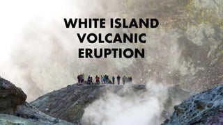
- 3. LOCATION • Whakaari/White Island is an active andesite stratovolcano situated 48 km from the east coast of the North Island of New Zealand, in the Bay of Plenty. • The island covers an area of 325 ha, which is only the peak of a much larger submarine volcano. • The volcano explosively erupted on 9 December 2019 at 2:11pm.
- 4. WHAT HAPPENED? • There were 47 people on the island at the time. • 21 people were killed, and a further twenty-six people suffered injuries, many of whom suffered severe burns. • There was an ongoing seismic and volcanic activity in the area as well as heavy rainfall, low visibility and toxic gases hampered recovery efforts over the week following the incident. • Experts identified the event as a phreatic eruption: a release of steam and volcanic gases that caused an explosion, launching rock and ash into the air.
- 6. BACKGROUND • White Island is an active volcano, situated 48 km off the north-northeast coast of the North Island of New Zealand in the Bay of Plenty. • The volcano has erupted many times in recent history, including several times in the 1980’s. • A major eruption formed a new crater in 2000, and small eruptions occurred in 2012, 2013, and 2016. • The volcano had been showing signs of unrest for several weeks before the 2019 eruption. • In October 2019, volcanic tremors and sulphur dioxide gas were at their highest levels since 2016, indicating that an eruption was more likely to occur.
- 8. THE ERUPTION • On 24 November, two weeks prior to the eruption, a moment magnitude 5.9 earthquake lasting approximately one minute with an epicentre located 10 kilometres northeast of White Island occurred, and was felt by people throughout New Zealand as far south as Christchurch. • Seismic activity can be a contributing factor to hydrothermic eruptions, due to a reduction of pressure within the geothermal system. • The island is monitored by GNS Science with three web cameras, one seismograph, and a microphone to detect volcanic explosions. • The organisation also makes regular visits to test water, gas and soil, and to survey surface deformation.