SlideShare a Scribd company logo
1 of 65
Download to read offline
The Effects of an “Urban Village” Planning and Zoning Strategy in San Jose, California
version: 24 June 2020
C.J. Gabbe
Dept of Environmental
Studies and Science
Santa Clara University
Santa Clara, CA 95053
cgabbe@scu.edu
Michael Kevane
Department of Economics
Santa Clara University
Santa Clara, CA 95053
mkevane@scu.edu
William A. Sundstrom
Department of Economics
Santa Clara University
Santa Clara, CA 95053
wsundstrom@scu.edu
Abstract
Rezoning commercial and residential parcels to permit mixed-use and higher density
development in cities is a potentially important policy response to a variety of pressing urban
planning issues, including housing affordability and transit congestion. Yet, comparatively little
is known about the effects of density-increasing “upzoning” on these outcomes. We study the
impacts of a major 2011 planning and zoning initiative – the designation of “urban villages” – on
real estate development in the city of San Jose in California. We use several measures of
development-related outcomes– permits for residential and commercial development, large
development projects, parcel transactions, parcel assessed values–tracked before and after the
urban village initiative. The estimated treatment effects, across specifications that vary by parcel
use code, treatment periods, and identification strategy, suggest quite limited impact. We discuss
potential reasons for the modest impact of the urban village strategy to upzone San Jose.
Keywords
Zoning, housing, affordability, urban planning, San Jose, California
JEL codes
R11, R21, R31
Corresponding author: Michael Kevane, Department of Economics, Santa Clara University,
Santa Clara, CA 95053, mkevane@scu.edu
1. Introduction
Some growing U.S. cities are responding to pressing challenges — including high housing prices
and climate change — by “upzoning” commercial and residential parcels. Upzoning may be
defined as an increase in allowable residential density or an increase in allowable development
intensity more generally. Cities that enable increases in housing supply on the extensive margin
are expected to have lower overall housing prices, but less is known about how specific planning
and zoning interventions might affect development outcomes on the intensive margin
(sometimes referred to as “densification”).
We study the effects of the San Jose, California municipal “urban village” planning and
zoning strategy on property values and real estate development outcomes. We use several
measures of development-related outcomes: transactions, changes in assessed property
valuations, and permits for residential and commercial development. Our basic estimation
strategy is difference-in-difference, comparing parcels included in urban villages with other,
comparable, parcels.
San Jose is a useful case study because of the city’s size, economic growth, and high
housing prices. San Jose is the largest city in Silicon Valley — and the 10th largest city in the
United States — with a population of over one million. Over the past two decades, San Jose’s
population has grown at a rate similar to the country as a whole, but its economic growth has
been much more rapid. Between the trough of the Great Recession in 2009 and 2017, metro San
Jose’s GDP grew by 84%, compared with 35% nationally.1
Housing prices have also escalated
dramatically. Between 2000 and 2019, average home prices in San Jose rose by about 185%,
compared with 86% nationally, according to Zillow estimates.2
In mid-2019, these estimates
showed the median home value in San Jose to be about $1 million. High — and rising — prices
and rental rates have given rise to a widespread perception of a housing affordability crisis in San
Jose and the San Francisco Bay Area generally.
The City of San Jose’s Envision San José 2040 General Plan, approved in 2011, sought
to connect housing and employment land uses, better use existing infrastructure, and encourage
non-auto transportation. A key component of the general plan was to direct growth into 68 areas
1
Total Gross Domestic Product for San Jose-Sunnyvale-Santa Clara, CA (MSA) and for the United States, annual,
retrieved from FRED, Federal Reserve Bank of St. Louis; https://fred.stlouisfed.org/series/GDPA and
https://fred.stlouisfed.org/series/NGMP41940 , November 4, 2019.
2
Zillow estimates downloaded from https://www.zillow.com/research/data/ July 18, 2019.
1
by designating them as “urban villages.” Many of these areas were commercially zoned and
proximate to public transportation corridors and hubs. The general plan itself was implemented
by more detailed plans for specific urban villages designated for near-term growth. These urban
village plans were intended to enable higher development densities and a mixture of land uses.
We refer to these detailed urban village plans as “upzonings” because they permitted higher
densities. Although the plans did not themselves automatically change existing zoning, the
planning process was predicated on subsequent approval of zoning change requests or
development entitlements.
The anticipated effects of the urban village designation on development, rents, and
property values are ambiguous and thus empirical questions.3
To the extent that an urban village
designation would enable higher densities and perhaps a loosening of other restrictions, it could
stimulate an increase in the local supply of housing and thus relieve upward pressure on housing
rents and prices. On the other hand, if the urban village plans impose more controls or fees on
aspects of development, they could impede housing development. For example, a Santa Clara
Valley Transportation Authority (VTA, 2019, p. 11) study noted for an area near one planned rail
transit station that the “... potential for residential development in the station area may be limited
by San José’s Urban Village policy, which restricts the location and timing of residential
development.” Additionally, anticipated amenities associated with urban villages could increase
local demand and drive up prices. With respect to the volume of real estate transactions, urban
village effects are also ambiguous: transactions might increase if prior owners sell to developers,
but might be muted due to the increased option value of banking undeveloped land
(Cunningham, 2006, 2007).
We estimate the effect of urban village upzoning by comparing the experience of a
variety of groups of parcels in the period after 2011. These strategies include: (1) comparing
urban village parcels to “synthetic villages,” clusters of contiguous parcels zoned for commercial
and multi-family use that are grouped in areas similar to the urban villages; (2) comparing
approved urban village areas to unapproved urban villages; (3) comparing urban villages to areas
known as Specific Plan areas; and (4) comparing urban villages slated for approval and
development sooner than others (that is, with earlier Horizons). We focus on parcels zoned for
multi-family and commercial use. Few single family homes were included in the urban village
areas, and the urban village planning strategy was not intended to upzone single-family
residential designations.
We estimate the average change in several outcome indicators: construction permits,
major projects, transactions, and assessor valuations. We presume that the intent of the urban
3
Some informed commentators referred to the urban villages as a major component of the General Plan. Leah
Toeniskoetter, San Jose director of SPUR, a major public policy think tank, observed: “The big idea in the plan is to
create urban villages, specific areas that will provide active, walkable, bicycle-friendly, transit-oriented, mixed-use
urban settings for new housing and job growth… In a sense, the new San Jose General Plan follows the current
convention of American planning, protecting most of the city from change, while designating a smaller number of
sites for intensive development. But you get a sense of the enormous scale of San Jose’s ambition from the number
— 70! — of designated urban villages.” (Toeniskoetter, 2011).
2
village strategy was that parcels so-designated would experience more building permits, more
major projects, more transactions, and larger increases in assessor valuations (valuations rise due
to sales).
We find that the urban village upzoning appears to have had no sizable positive effects
over the 2011-2019 period after the General Plan was approved, in terms of accelerating
development or increasing transactions or leading to increases in assessed values of the
designated areas.
Methodologically, much research on urban development ignores the complex changes in
composition of urban parcels as developers split and consolidate parcels. Data analysis on
development outcomes over time have to consistently track the experience of parcels. Depending
on the method used, transactions, construction permits, and changes in assessed value must be
attributed to the consistent parcels. We implement three different aggregation methods to
generate consistent parcels over time: using 2005 parcels as “base” parcels, using 2019 parcels as
“base” parcels, and using the smallest consistent parcel group as the consistent parcel.
The paper proceeds as follows. Section 2 reviews the literature on zoning and housing
prices and availability. Section 3 summarizes the important aspects of San Jose’s urban village
strategy. Section 4 describes the data we use in our quantitative analysis, the consistent parcel
aggregation methods, and the difference-in-difference identification approach taken to estimate
the impact of the changes in zoning. Section 5 presents the results. Section 6 suggests some
further areas of research and offers some concluding comments.
2. Planning, zoning, and housing markets
Recent scholarly debates have concerned the effect of restrictive zoning on housing prices and
overall economic growth (Angotti, 2017; Erdmann et al., 2019; Hilber & Vermeulen, 2015; Hirt,
2015; Ihlanfeldt, 2007; Jackson, 2016). An influential argument is that housing supply
constraints — including restrictive single-family zoning, reluctance by cities to rezone
commercial corridors for housing development, fees, and unpredictable development approval
processes — are major causes of rising prices for housing, and those rising prices are inhibiting
aggregate economic growth by slowing movement of the labor force away from low opportunity
cities towards high opportunity cities. High housing prices in dynamic urban centers dampen the
growth potential of such centers, lowering aggregate growth and more importantly opportunities
for individuals to match talents and investments to places with high demand (Hsieh & Moretti,
2019).
On the other side of the debate are scholars who find that housing development and
housing prices are much less sensitive to zoning changes than supposed. Some argue that
changes in patterns of demand, for example through growing inequality in the distribution of
earnings, have been responsible for rising prices and greater displacement (Rodríguez-Pose &
Storper, 2019) (Rodríguez-Pose & Storper, 2019). Others focus on the tight housing construction
sector, and possible oligopoly strategies of developers, that limit housing supply responses
(Coiacetto, 2009; Cosman & Quintero, 2019; Wissoker, 2016). Metcalf (2018) suggests that
3
because the demand effects are so large, and the supply response so limited, publicly provided
social housing, rather than just changing zoning, is also necessary to improve housing access,
especially for low- and moderate-income residents.
“Upzoning” generally refers to zoning changes and planning overlays that allow higher
development densities. Some definitions have focused on allowable residential densities (Been et
al., 2014; Gabbe, 2018), while other broader definitions include development intensity more
generally (Cullingworth, 1993; Fischel, 1987; Whittemore, 2017). Common forms of upzoning
under the former definition include relaxing commercial zoning to allow residential and mixed-
use development and changing single-family home zoning to allow multi-family residences.
Upzonings may be initiated by property owners or municipal leaders; in San Jose, upzonings
have been rare and mostly initiated by property owners (Gabbe, 2019).
There are several reasons why it is empirically challenging to identify the causal effects
of upzonings or other land use policies on housing market outcomes. The immediate obstacle to
estimating causal effects is that zoning changes are likely to be endogenous, responding to
perceptions by city officials of the likelihood of development in particular neighborhoods of a
city (Ihlanfeldt, 2007; Quigley & Rosenthal, 2005). Zoning is determined at local levels, with
small numbers of actors having significant influence over local zoning decisions. City officials,
developers, and established residents anticipate changes to neighborhoods and influence the
zoning decision-making processes according to those expectations (Fischel, 2005; Molotch,
1976). A second estimation problem is that zoning changes may spill over from targeted zones
and have effects on other zones (Pollakowski & Wachter, 1990). To the extent that local housing
markets are connected rather than segmented, such general equilibrium effects may be
significant. Finally, the impacts of zoning changes are likely to be heterogeneous and vary from
neighborhood to neighborhood.
Perhaps because of the significant challenges, there have been few well-identified studies
of the impacts of upzoning at the parcel scale. Difference-in-difference (DD) estimators have
been increasingly adopted for evaluation of the impact of policy changes that were likely to have
affected real estate markets. Sage, Langen, and Van de Minne (2019) use DD to estimate the
magnitude of the short-term effects of the Opportunity Zone designation in the 2017 tax reform.
Neumark and Kolko (2010) used DD to estimate the effects of California’s enterprise zone
designation. They used two control groups: a 1 km “ring” around the enterprise zone, and areas
that were added to enterprise zones at different times. Freemark (2019) estimated the effect of
Chicago’s upzoning of certain parcels around mass transit stations. In 2013, Chicago decided to
upzone certain parcels within 600 or 1,200 feet of rail transit stations and in 2015 expanded the
range to 0.25 or 0.5 miles. Because the boundary of the upzoning was basically random relative
to parcel pre-existing development, and parcels on either side of the boundary were similar,
Freemark compared parcels inside the boundaries with those just outside the boundaries. He
found that upzoning increased property values but had no impact on the number of newly
permitted dwellings, in the five year period after the zoning change.
4
Some researchers have used observational data of differences between cities or
metropolitan areas and found (1) negative correlations between indices of restrictive land use
regulations and measures of housing production and (2) positive correlations between regulatory
restrictiveness and housing prices (Glaeser & Gyourko, 2018; Glaeser, Gyourko, & Saks, 2005;
Ihlanfeldt, 2007; Jackson, 2016; Pendall, 2000; Quigley & Raphael, 2005). These observational
studies do not adequately address causality: for example, it may be that homeowners anticipating
higher valuations for their homes seek to lock-in their appreciation by restricting potential new
supply. The regulations are then partly a consequence of appreciating home prices. Additionally,
geographic features of cities, such as steep slopes and water bodies, may be correlated with
restrictive regulations, housing production, and prices (Saiz, 2010).
Another approach taken in the literature is to compare the price of housing with an
estimated marginal cost of housing, or marginal cost of additional housing units in multi-unit
buildings. Many of these studies find large differences across jurisdictions and attribute these
differences to the impact of zoning (Kendall and Tulip 2018; Glaeser and Gyourko 2018). More
recent analysis has taken into account the general equilibrium spillover effects of variation in
regulation in different parts of a city (Kok et al., 2014; Lin & Wachter, 2019).
Beyond zoning changes, a closely related literature points to several factors that may
affect housing prices near public transit. Rail stations may be associated with changing housing
and condominium prices because of accessibility benefits and local amenities, but proximity may
also act as a disamenity – with noise and congestion – dampening prices closest to a station
(Atkinson-Palombo, 2010; Bowes & Ihlanfeldt, 2001; Kahn, 2007; Matthews & Turnbull, 2007);
Duncan 2011; Atkinson-Palombo 2010). Station area design seems to be important, as walkable
rail station neighborhoods are associated with higher housing prices than auto-oriented station
neighborhoods (Atkinson-Palombo, 2010; Kahn, 2007).
This literature suggests that specificities of local neighborhoods may be quite important
in property development decisions. Atkinson-Palombo (2010) is particularly relevant because the
author uses hedonic models to parse out the separate effects of transit-related accessibility and
overlay zoning on the price of single-family units and condominiums. Transit-oriented
development (TOD) overlay zoning, which allowed higher density development, had different
effects depending on housing type and neighborhood context. For single-family housing, the
TOD overlay zone resulted in no price differences in mixed-use neighborhoods and 12% lower
prices in traditional residential neighborhoods. For condominiums, the TOD overlay resulted in a
37% price premium in mixed-use neighborhoods and an 11% price decrease in traditional
residential neighborhoods.
Development patterns may affect tax revenue and the cost of public service provision,
and municipal land use decisions may be influenced by the fiscal impacts of new development.
The direct mechanisms connecting land use and public finance are through revenues (e.g.
property taxes, sales taxes) and expenditures (e.g. cost to provide public services, infrastructure
costs) (Paulsen, 2014). Planners and policymakers commonly consider the fiscal impacts of new
development in decision making (Lewis, 2001; Paulsen, 2014; Wassmer, 2002). Miscynski
5
(1986) coined the term “fiscalization” of land use to describe the idea that local land use
decisions in California were often driven by a desire to increase a municipality’s tax base. For
example, cities might be driven to compete for sales tax generators such as automobile
dealerships or big box stores (Lewis, 2001; Wassmer, 2002).
3. San Jose and its urban villages
In some ways San Jose, and the Bay Area broadly, are extreme cases in planning and housing
development. Of the 50 largest cities in the U.S., San Jose had the highest median income and
median rents, and the second highest housing values — after San Francisco — in 2018 (U.S.
Census Bureau, 2018). Meanwhile, San Jose has suffered from major fiscal problems,
experiencing an “acute fiscal strain” during the dot-com bust and the Great Recession, and lacks
the resources to address deferred maintenance and invest in the future (Szambelan et al., 2016, p.
11). While the city has engaged in planning, it has not updated its zoning to be consistent with
these plans due to the city’s financial situation, and relies on its general plan to make
development decisions (Karlinsky et al., 2017; Liccardo, 2017).
But, in other aspects, San Jose is like many other American cities. San Jose was
developed largely post-World War II and aspires to reduce its associated dependency on the
automobile (City of San Jose, 2011). The city favored commercial and industrial development
over new housing for fiscal reasons, despite some indications that high density housing has net
positive fiscal impacts (City of San Jose, 2011; Svensson, 2015). One of the biggest barriers to
new housing construction is high construction costs, which according to some estimates are $81
per square foot higher in the Bay Area, holding project characteristics constant, than the
California average (Raetz et al., 2020; Reid, 2020). Other barriers to developing more market-
rate and affordable housing in San Jose and the Bay Area possibly include unpredictable and
lengthy approval timelines and the complexity of financing affordable housing developments
(Karlinsky et al., 2017; Reid, 2020).
San Jose’s approach to planning and zoning is guided by local and state requirements, the
major components of which are general plans, zoning codes, subdivision regulations, and
specific plans. California has long required every city to adopt a comprehensive plan, known in
the state as a general plan (State of California, 2017). Each general plan includes a set of
required elements, but cities have considerable flexibility with the content of their plans. General
plans are implemented by local land use regulations, which are mainly in zoning codes and
subdivision regulations. San Jose’s land use regulations stipulate building heights, densities,
parking, landscaping, and affordable housing requirements, among other things.
The state of California requires consistency between most jurisdictions’ general plans and
zoning codes; an exception is for charter cities with fewer than 2 million residents, of which San
Jose qualifies (State of California, 2017). Beyond state requirements, California cities have
considerable latitude to plan and zone. Cities may approve some developments as planned
developments, which are site-specific planning and development approvals that supersede the
underlying zoning designations (Meck et al., 2000). California also has had a unique type of
6
hybrid long-range plan and land use regulatory document known as a specific plan, of which San
Jose has adopted ten (City of San Jose, n.d.; State of California, 2001).
San Jose — like many other growing West Coast cities including Seattle — has embraced
the idea of creating “urban villages.” San Jose in 2011 identified 68 areas to be designated as
urban villages, which are described as “active, walkable, bicycle-friendly, transit-oriented,
mixed-use urban settings for new housing and job growth [...]” (City of San Jose, 2011, p. 18).
The urban village strategy was one of the city’s 12 major strategies for managing city growth,
per the general plan Envision San José 2040, adopted in 2011 (City of San Jose, 2011). The goal
was to enable more urban-style development in what was a largely a lower density suburban city.
Each plan would enable conversion of commercial-only parcels to mixed-use parcels. After
community engagement, the city council would approve an urban village plan for each
designated area. By mid-2019, eight years after the general plan was adopted, 13 urban village
plans had been approved.
San Jose defined four categories of urban villages. Regional Transit Urban Villages were
located near Bay Area Rapid Transit (BART) and Caltrain stations and would include the highest
density employment and residential land uses. Local Transit Urban Villages were located near
light rail and bus rapid transit (BRT) stations and would include a mix of uses, but lower
densities than the regional transit urban villages. Commercial Corridor and Center Urban
Villages were typically along major arterials or at intersections of two arterials. Neighborhood
Urban Villages were small-scale neighborhood-serving commercial developments with limited
new housing (City of San Jose, 2011).
Each urban village was also assigned to one of three categories, known as Horizons, that
required certain milestones to be reached before an approved plan could be implemented. The
most central and highest intensity urban villages were generally in the first and second horizons,
while the smaller-scale and outlying urban villages were in the third horizon. One of the
appendices in the general plan specifies growth capacities for downtown, employment centers,
and urban villages by horizon. Only urban villages in Horizon 1 are permitted to grow at the time
of writing; this phasing is reviewed on a four year cycle (City of San Jose, 2011).
Urban village plans were not straightforward upzonings. The city’s Urban Village
Implementation and Amenities Framework added two zoning designations that could be applied
to parcels within urban villages: an urban village commercial zoning district (UVC) and an urban
village mixed use zoning district (UVMU). The urban village designations were a new form of
land use regulation in the city, with the designations reducing some requirements for property
owners, while adding others. The city council noted that the “intent of this Framework is to
ensure that applications for a zoning change from commercial to residential or residential mixed-
use in urban villages will only be considered by the City for approval if the developers share the
increase in value of their projects from such zoning changes to residential use by constructing,
providing, or otherwise funding amenities and public improvements as identified in the
applicable Urban Village Plan [...]” Thus, market rate mixed use development was required to
provide urban village amenities equivalent to 2% of the total project value, calculated on a basis
7
of $555 per square foot, and would get “extra credit” for building amenities as part of the project.
These amenities could include privately maintained public open spaces (such as plazas), public
art, extra commercial space, and off-site improvements.
Although our study is to our knowledge the first econometric analysis of the impact of
San Jose’s urban village plan, analysis by local advocates has noted the apparent slow pace of
development in these areas since the release of the 2011 general plan. A 2019 report by the urban
planning advocacy organization SPUR, for example, found that major development projects
launched in San Jose since 2011 were largely located outside of urban villages in the city’s
downtown and commercial and industrial northern district, and suggested some potential reasons
for this discrepancy (Wang, 2019).
At the time of writing, the city of San Jose was in the process of modifying its urban
village strategy somewhat. City staff recommended removing two urban villages and adding two
new urban villages. Meanwhile, members of a task force charged with reviewing the general plan
unanimously recommended eliminating horizons altogether, while staff recommended keeping
the horizons approach intact and moving several existing urban villages to Horizon 1 because of
perceived market demand (City of San Jose, 2020c). Staff also proposed some revised
requirements for “signature” projects (City of San Jose, 2019). These deliberations show
policymakers’ and stakeholders’ shared interests in better aligning the urban village strategy with
the city’s goals, but indicate disagreements about the extent of changes necessary for doing so.
4. Data and estimation strategy
We seek to quantify the impact of urban village designations on urban development outcomes,
including indicators of real estate development, such as issuance of construction permits,
approvals for major projects, real estate property transactions, and changes in assessor valuations
occasioned by sales or improvements.
The endogeneity of initial selection, plan content, and changing of horizons, means that
naive estimates of the development effects of urban village designation are likely to be biased.
The urban village boundaries and plan adoption may have been influenced by staff assessment
about the likelihood of mixed-use development to occur and by community opposition to
upzoning and higher density. Some of the contemporaneous discourse around the urban village
policy suggests that the more likely development was to happen, the more likely the zone was
designated as an urban village, given an earlier horizon, and accelerated in the approval process.
An anecdote suggests the likelihood of endogeneity of the timing of implementation or
activation of urban village plans. In December 2018, the city council approved a
recommendation by the planning staff to immediately shift the Horizons of eight urban villages
(4 approved, 4 as-yet unapproved), from Horizons 2 and 3 to Horizon 1 (“San Jose,” 2018). The
planning staff’s memo illustrates the endogeneity of decisions about urban village content and
timing; related to one set of urban villages, staff noted that “West San José is the primary area of
San José where housing is anticipated to be built under current market conditions” (City of San
Jose, 2018b).
8
We estimate the effects of the urban village policy – in essence a change in policy for
some geographically defined zones and not for others – with a basic difference-in-difference
(DD) approach. Specifically, we compare changes in outcome variables between pre- and post-
treatment periods across various definitions of treated and untreated (or control) units, separately
for commercial and for multi-family residential properties. Since the urban villages by definition
were areas along commercial corridors, we cannot use the boundary between commercial and
non-commercial areas itself as a difference. Most urban villages have commercial or multi-
family zoned parcels on the urban village side of the boundary and parcels zoned for single-
family housing on the other side of the boundary.
We collapse annual data for the pre-treatment years into the period 2005-2010 and post-
treatment years into two alternative periods: an immediate 2011-2015 period and a later 2014-
2019 period. Comparing two post-treatment periods allows for the possibility of delayed or
longer-term impacts.
Data
We follow the advice of Krause and Lipscomb (2016) in being transparent and replicable in the
many data preparation decisions that have to be made for analysis of real estate data. The office
of the Santa Clara County Assessor is the source for most of the data. They provided the Secured
Assessment Roll (AMF) for 2005-2015 with Assessor Parcel Number (APN), gross secured
value, and tax rate area. The file has 5,196,955 observations (about 500,000 parcels observed for
11 years). We subsequently purchased the 2018 Master file, which contains gross secured value
for all APNs for 2018 and 2019. The assessor office also provided a 2015 file of 483,648 APNs
with their zip codes and use codes. There are 99 use codes defined by the Santa Clara County
assessor. We aggregated the codes into several broad categories, discussed below.
We also obtained the Condensed Sales files for the period from 2014 through June 2019.
These files contain a record of property transfers in Santa Clara County with APN, recording
date and transfer dates, indicated price, and names of prior assessee and current assessee.
Building permit data is accessible from the Permit Center website of the City of San Jose.
All permits from 2005 through 2019 are available in publicly available tab-delimited text files,
and include address and APN for the permits. Unfortunately, the format of the permit files are
such that only a few broad categories of permits are identified. There is no field for the
approximate value of the work to be undertaken, so from the files it is hard to distinguish, for
example, a complete interior remodel of a building and a small alteration to one part of a
building. We privilege then a category included in the field “work description” in the permit
files, category New Construction (other major categories include Additions/Alterations,
Demolition, Finish Interior, ReRoof, Sub-Trades Only, and Tenant Improvement).
We also examine major projects. The City of San Jose every year publishes a report of
building projects in the city, which it defines as residential projects with at least 50 housing units
and commercial projects with at least 25,000 square feet (City of San Jose, 2020a). The reports
9
list all the major projects permitted or in the approval process. These projects are listed with
address and APN number.
For both the permit and major project data, the APN for and year of issuance of the
permit, or the APN for and year a major project appears on the list, may not correspond to an
APN and year present in the Assessor Roll. As noted below, development of real estate often
leads to a change in the APN numbers as parcels are split or merged. The APN listed at the time
a project is launched may not correspond to an APN for that Roll year. We adopt a “fuzzy”
merge for the permits and major projects. The vast majority merge with their listed APN and
year, but for the fraction that do not we adjust the year forward by a year, and then merge. For
the remaining fraction we adjust the year to be one year prior to the listed year, and merge. For
those that remain unmerged, we adjust by two years, and merge, and then repeat by adjusting the
year variable by three years. We thus are able to link more of the permits and major projects. The
fraction of entries that merge through this process is small, and might introduce a small
measurement error in the sense that the timing of the permit or major project might be incorrectly
assigned to the “post 2011” period rather than to the “pre 2011” period.
Our fourth outcome variable is the parcel secured assessed value. The fiscal implications
of this value are substantial for county and city decision-makers as the assessed value is the basis
for property tax assessment. The state’s 1978 Proposition 13 generally limits allowable increases
in assessed value to the lesser of 2% per year or the California Consumer Price Index (California
LAO, 2012). This value is known as the “factored base year value” (County of Santa Clara, n.d.)
There are several exceptions. First, if a property is sold, its assessed value resets to its acquisition
price. Second, if a property owner makes substantial improvements, the assessor will reassess the
improvements only. Third, if the market declines and a property’s assessed value exceeds its
market value, the assessor can temporarily reduce assessed values under the provisions of the
state’s 1978 Proposition 8, and later return the assessed value to its factored base year value
(California LAO, 2012). Observed assessed values thus are not current market valuations but a
mix of different vintages of market values depending on the most recent such sale.
The City of San Jose made available spatial data files for the general plan, zoning, and
other special designations (City of San Jose, 2020b). We use these to identify whether parcels
fall within the boundaries of urban villages and other planning areas.
Constructing consistent parcels
Our unit of analysis is the parcel, defined by the Santa Clara County Assessor office. Parcels are
assigned APN numbers. When parcels are split or combined through real estate transactions or
development, new APN numbers are assigned by the assessor. Development projects also often
lead to redrawing of assessor maps, and new APN are assigned because the APN numbers refer
to pages in the map “book.” An important data preparation problem in real estate data analysis is
record linkage to track parcels over time, and create a panel of consistent parcels. Two methods
may be used: using shapefiles from each year to infer patterns of splits and combinations, or
using crosswalks or key files to track changes and reconstruct parcel “parents” and “children.”
10
We use the Assessor crosswalks and three different “base” methods for creating a panel of
consistent parcels from 2005 to 2019: using 2019 parcels as the “base” set of parcels
(“Consistent 2019”); using 2005 parcels as the “base” set of parcels (“Consistent 2005”); and
using a minimum consistent parcel group as the unit of analysis (“Consistent grouped parcels”).
Appendix A discusses the methods used in the paper to link parcels over time and so create a
consistent panel of outcomes at the parcel level.
Descriptive statistics
Table 1 shows the number of parcels, by broad use category, allocated to the different Horizons,
and the proportion of parcels in urban villages as of 2019. The urban village parcels together
comprised about 6,300 parcels, or 2.7% of the approximately 230,000 parcels in the city of San
Jose with residential or commercial land uses in 2019. (We exclude public, industrial, and other
more specialized and restrictive types of parcels.) More importantly, urban villages included
about 1,900 parcels with commercial uses, out of about 5,000 commercial parcels in the city;
thus about 38% of the city’s commercial parcels were potentially open to mixed-use and higher
development intensities in urban villages. Additionally, about 7% of the city’s 49,000
multifamily rental parcels, condominiums, and townhouses were included in the urban village
boundaries. Fewer than 1% of the 175,000 parcels with single family home uses were included in
the urban village boundaries.
We note that the City Council reassigned several urban villages from Horizon 3 to
Horizon 1 in December 2018; that reassignment is not reflected in the table, which uses the
original Horizon designations of 2011.
11
Table 2 presents descriptive statistics for the outcome variables used in the analysis, over
the 2014-19 period. These include the average assessed values of parcels, the average number of
transactions per parcel, the average number of permits pulled per parcel, of any sort of permit,
and the mean number of major projects (per 1000 parcels), according to use categories and
horizons. The parcels are grouped according to some of the comparison categories: in urban
villages; in algorithm generated control areas; in Specific Plan areas; and other parcels. As
shown, commercial properties outside of comparison areas had average assessment valuations of
about $4.1 million, while in urban villages assessment valuations averaged $2.7 million. Parcels
zoned for multi-family use ranged in value from $700,000 to $1.3 million. Finally, for single-
family homes, the average assessment valuation was in the $500,000-$800,000 range. As noted
earlier, urban villages by design contained relatively few single-family homes.
Commercial and multifamily parcels saw an average of transactions ranging from 0.09 to
0.36 over the 2014-19, suggesting that roughly 15% of commercial parcels transacted over the
five year period while about 30% of multi-family parcels transacted. It appears that about 20% of
single-family parcels transacted over the period. Note that the table reports the mean of the sum
of transactions over the 2014-19 period for each parcel: some parcels transacted multiple times
during the period. So the number is close to but not quite the probability of a parcel transacting.
The table also reports the mean of the number of permits pulled, and the mean number of
major projects (per 1,000 parcels, for convenience). As can be seen, the groups had quite
different experiences over the 2014-19 period, but it should be borne in mind that they may also
have had different experiences during the 2005-11 period: of interest is the change in the
likelihood of transactions, permits and projects, not the level.
Estimation strategy
We follow a standard difference-in-difference methodology. Given an assignment of parcels
(consistent parcels, to be more precise) to treatment and control status, let Yijt represent an
12
outcome variable for parcel i in treatment or control area j in at time t. Then ∆Yij = Yij1 - Yij0
represents the change in outcome between the pre- (t=0) and post-treatment (t=1) periods, and
treatment status is Zij = 0 for units in untreated areas and Zij = 1 for units in treated areas. The
conventional DD estimator is:
E[∆Yij | Zij=1] - E[∆Yi | Zij=0]
We collapse annual data for the pre-treatment years into the period 2006-2010 and post-
treatment years into two alternative periods: an immediate 2011-2015 period and a lagged 2014-
2019 period.4
In practice, we have a wide range of potential treatment categories to compare, such as
parcels in control areas, parcels in Specific Plan areas, parcels not belonging to any urban
village, parcels in Horizon 1 urban villages, in approved urban villages, in any designated urban
village, and so forth. To facilitate multiple comparisons across alternative treatment statuses, we
report and compare slope estimates from the following simple pre-post regression for various
subsamples of consistent parcels defined by treatment category:
Yijt = αj + βj Djt + μijt
where i is the consistent parcel or parcel group, t is the time period (0 for the pre- treatment
period and 1 for the post-treatment), Yijt is the outcome, j is the treatment or control area, and Djt
is a dummy = 1 for the post-period. The coefficient βj is the change in mean outcome between
pre- and post-periods for parcels in the subsample: βj = E[∆Yij]. We estimate βj for a variety of
subsamples defined by treatment category as well as separately for commercial and multi-family
use categories.
One identifying assumption for DD is common or parallel trends in the treated and
untreated units under the counterfactual of no treatment. Endogeneity of the treatment could be
associated with a violation of the common trend assumption. For example, suppose as noted
earlier that “treated” urban villages were selected for earlier implementation (treatment) because
they were in more dynamic parts of the city, with more rapidly rising property values than
untreated urban villages. Then the counterfactual trend in property values in the treated urban
villages had they been untreated would be different from the trend in untreated villages,
violating the common trends assumption.
Documents written by city planning staff suggest that urban village approvals and
changes to urban village plans responded to perceived interest by developers. The timing of
rezoning and the content of the rezoning plans were therefore possibly not “as good as” random.
Of course, it is also possible that city staff justifications of changes in zoning were wishful
thinking based on casual empiricism and anecdote, and thus basically random. Moreover, it is
possible that the areas of the city that were already in processes of redevelopment were viewed
by staff as not needing to be included as urban villages.
4
Although our panel starts in 2005, the analysis samples start in 2006, because our measure of inferred transactions
or development based on assessor revaluation is based on the one-year change in assessed value, the calculation of
which requires dropping the initial year of data.
13
Control groups
Difference-in-difference strategy is only as good as the reasonableness of the control group that
is to be compared with the treatment group. Identifying appropriate comparison control groups
for urban villages is challenging since the areas were not randomly selected from a population of
potential zones that could have been designated as urban villages. There likely was some
endogeneity in the selection process.
One common strategy for constructing control groups is to consider treatment borders as
basically arbitrary, and compare units inside the border with those outside the border. Urban
village impacts in San Jose, however, cannot be estimated by comparing parcels on either side of
the urban village boundaries. The boundaries of urban villages were deliberately drawn to
include parcels on the commercial avenue or in close proximity, and exclude single-family home
areas often just one parcel away from the urban village. Thus urban villages were “strips” along
an arterial. The “ends” of the strips of urban villages were often natural boundaries such as
bridges, highways, or large existing commercial developments. There is no reason, then, to
suppose that parcels on opposite sides of the boundaries would be similar or comparable, either
prior to the urban villages or after the urban villages. This precludes a strategy such as that of
Freemark’s study of upzoning in Chicago (Freemark, 2019).
We consider instead four comparisons that treat the timing and location of treatment as
basically arbitrary in a relatively narrow timing window and region. These four comparisons are
explained below and compare: (1) urban villages with synthetic agglomerations that are similar
to urban villages in having a mix of commercial and multi-family parcels grouped together; (2)
urban villages with other similar designated areas (Specific Plan areas); (3) urban villages in
Horizon 1 with urban villages in H2 and H3; and (4) urban villages that have been officially
adopted (with approved plans) by the city with as-yet non-adopted urban villages. The
comparisons are such that reasonable interpretations of the goal of the urban village strategy to
densify through upzoning would imply that the first group (the H1 urban villages, or the
approved plan urban villages), would have higher proportions of parcels permitted for
development and transacting compared with the comparison group, in the period after the urban
village strategy was launched, compared with the parcel activity prior to the urban village
strategy.
Two of the comparisons involve the timing aspects of urban villages: we compare parcels
in Horizon 1 urban villages with those in Horizons 2 and 3, and we compare parcels in urban
villages that have approved plans with parcels in urban villages that do not have approved plans.
As noted earlier, there were two related timing variables associated with the urban villages: the
assigned Horizon, and the local engagement process and city council approval of an urban
village plan. Some urban villages were designated Horizons 2 and 3, and planning staff
suggested that zoning would likely not change for a decade or more after 2011. Staff
recommended, and the city council approved, changes in the Horizons several times over the
2011-19 period. The approval process for plans appeared to be somewhat haphazard and
apparently partly driven by grant funding to cover the expenses of local engagement (meetings,
14
notifications, reproduction of materials, consultants). By 2019, 19 areas had urban village plans
approved, leaving 49 still in process or where the planning and community engagement process
had not yet begun. Most of the Horizon 1 urban villages had approved plans, while some of the
Horizon 2 and 3 urban villages did too. In-depth reading of staff memos and other city
documents suggests that both the Horizon and approval processes had substantial arbitrary
components.
The two other comparisons involve geographic and timing effects. In one we compare
parcels in urban villages (however designated) with parcels in other designated plan areas that
had been approved (and implemented) in the decades prior to the urban village strategy.5
These
other plans were known as “Specific Plans,” “master plans,” or “neighborhood plans.” Some
potential urban village sites had been evaluated as potential growth sites prior to the urban
village strategy, and thus had land use regulatory overlays that predated the General Plan of
2011.
The city had carved out two zones (downtown and Diridon station area) as also meriting
separate plans for zoning purposes. The zones are quite different from the urban village zones
and would seem to be poor comparison groups for evaluating the impact of urban village
upzoning.
In the fourth comparison we compare urban village parcels with commercial and multi-
family zoned parcels that are in other local “synthetic villages.” We first identify every
commercial and multi-family parcel in the city that is not in an urban village, specific plan area,
employment area, downtown, downtown core, or within 250 meters of the border of those areas.
Then we determine whether the parcel is in an “agglomeration,” defined as a cluster of at least 25
commercial or multi-family parcels, each within 100 meters of another commercial or multi-
family parcel in the cluster. To identify these neighboring parcels we search for the four nearest
commercial or multi-family neighbors within a search radius of 100 meters. These sets of
neighboring parcels then form the synthetic village comparison group of parcels that are in a
sense similar to urban villages (an agglomeration of parcels that are not single-family homes).
Many of the candidate synthetic areas have few or no commercial parcels. To rule out
agglomerations that are isolated multifamily housing developments with little mixed-use
potential, we adopt the criterion that the control areas must have at least 10 commercial parcels,
which leaves 18 synthetic villages containing a total of 1675 parcels. They range in size from 26
to 278 parcels, and thus are fairly representative of an urban village in terms of number of
parcels.
As a sensitivity check we also used an alternative definition of synthetic villages that set
the search radius to 50 meters, required a minimum of 50 neighboring parcels in the cluster, and
5
The other plan areas were: Alviso (plan approved 1998, 2,840 acres of urban use land), Communications Hill
(1992, 942 acres), Evergreen (1991, 879 acres), Jackson-Taylor a.k.a. Japantown (1992, 109 acres), Martha Gardens
(2003, 145 acres), Midtown (1992, 125 acres), and Tamien Station Area (1995,149 acres). Two other zones with
more complex histories are the Blossom Hill Rd/Hitachi urban village area and the Berryessa Swap Area (plan
approved 1982, 295 acres). Two other Specific Plan areas are not included: Rincon South (1998, subsequently
converted to an approved Urban Village plan#, 465 acres), and Silver Creek (1989, 134 acres), which appears to be a
planned golf community. See Data Appendix C for more information on these other sites.
15
allowed as few as 2 commercial parcels per cluster, allowing for more residential-type
agglomerations. As indicated in Figure 1 below, these “Synth Alt UVs” were decidedly less
commercial in character than the actual urban villages, and thus perhaps a less comparable
control group.
These synthetic village control areas include certain neighborhood commercial zones that
might have been obvious candidates for urban village designation but were not included: Willow
Glen, parts of Meridian Avenue, and parts of Cambrian. It is possible that community opposition
to higher density in these neighborhoods led to them not being included in the urban village
process.
Two other choices went into defining the universe of parcels included in the analysis.
One choice was to exclude mobile homes from the analysis. Mobile homes and associated
mobile home parks have complex characteristics in terms of their status as parcels. In the past,
mobile homes could be considered as unsecured property that could be “rolled away” if the park
were sold and developed. But increasingly, mobile home owners are considered by cities to be
stakeholders in the development process, and city councils have been under pressure to grant
permits for development of mobile home parks only if current mobile home residents are
guaranteed affordable housing in the new development.
Another issue concerns parcels that are not viable for their use code, as commercial or
residential. Conversations with staff at the Santa Clara Assessor office suggested that numerous
parcels in the city classified as commercial or multifamily might in reality have no economic
value or prospects for development. These consist of odd shaped “leftover” or “cutout” parcels
created during private development or public urban infrastructure work (streets, utilities). The
Assessor Office apparently would give these parcels nominal values. The staff suggested that
cutoffs of $50,000 for commercial and $20,000 for multifamily would capture these parcels, and
no economically worthwhile parcel would have an assessor valuation lower than those numbers.
Figure 1 displays the number of parcels in each of the groups outlined above. The urban
village areas have about 1700 commercial parcels, and 2400 multi-family parcels, varying with
the consistent parcel aggregation method. The two different “synthetic village” algorithms
produce about 500 and 300 commercial and about 1000 and 2100 multifamily parcels,
respectively. Recall the two have different algorithms, with the first designed to capture more
commercial clusters and the second capturing many for multifamily parcel clusters. The
“consistent 2019” method typically has the most plots for multifamily parcels, which as noted
earlier is because the common pattern in development is the building of apartment blocks which
are often assigned separate APN numbers, so that mechanically the hundreds of apartment blocks
built over the decades mean the “final” number of parcels will be the largest (consistent parcels
means these APN are aggregated back to their original larger parcel).
16
Figure 1: Numbers of parcels in various 'treatment or control' categories, for defined areas of
San Jose
5. Results
There are several hundred pre-post coefficients due to our outcome measures, selection of
comparison areas, methods of measuring consistent parcels, generalized parcel use code
17
categories, and post time periods. Again, the four outcome measures are whether the parcel had a
new construction permit over the time period, whether the parcel had an assessor revaluation or a
sale transaction over the period, whether the parcel was the location of a major project, and the
log of maximum assessor valuation over the period. There are 10 areas to be compared with each
other (abbreviating urban village as UV and horizon as H): UV H1, UV H2, UV H3, UV H123
combined, UV adopted plans, UV not-yet-adopted plans, Specific Plan areas, synthetic village
control areas (2 versions), and an “area” consisting of all other parcels in the city (called “All
other”). The three different ways to track consistent parcels are labelled “Consistent 2019,”
“Consistent 2005,” and “Consistent grouped parcels.” The two generalized use-codes for parcels
are commercial or multi-family. The pre-period is always defined as the five years 2006-2010,
and two alternative post-periods are considered: 2011-2015 and 2014-2019.
Table 3 anticipates the regression analysis, showing that there was not much development
activity happening in urban villages compared with the synthetic villages. Three of the outcome
variables are coded as dummy variables: Was there an assessor revaluation or property
transaction? Was there a permit for new construction? Was there a major project? Table 3
displays the counts for the positive outcomes for these variables, for two groups of parcels, the
parcels comprising the urban villages (inclusive of all Horizons 1, 2, and 3), and the parcels
comprising the synthetic villages. Separate columns for revaluations and transactions are
provided, given the change in data availability over our period. As can be seen in the table, the
number of positive values is quite sparse for the major projects and new construction permits for
both the urban villages and synthetic villages. There was very little development in either of
these areas.
18
Results from the regressions are displayed in four different sets of plots, Figures 2-5, each with 3
panels corresponding to the different ways of aggregating parcels. Each figure corresponds to a
different outcome variable. Each panel displays 40 estimated coefficients (10 comparison groups
of parcels, 2 use-codes, and 2 outcome periods). The plots are designed to provide a simple
comparison of the change in mean outcomes between the pre-treatment and the post-treatment
periods, across various categories of parcels. In each case, the dot and whiskers provide the point
estimate and 95% confidence interval, respectively, for the coefficient βj in the following
regression, for the relevant category j: Yijt = αj + βjDjt + μijt where i is the parcel or parcel group,
t = 0,1 for the before and after periods respectively, Yijt is the outcome of interest for parcel i in
19
period t, and Djt is a dummy variable for the post-treatment period, equal to 1 if t = 1 and 0
otherwise. For the three outcome variables that are binary (dummies), the regressions estimate a
linear probability model.
The data set used in each regression has two observations per parcel: the value for the
outcome for the parcel in 2005-10 and the value for the outcome for the parcel in the “post”
period. The explanatory variable is a dummy variable for the post-period. We use a balanced
panel for each regression; specifically, a parcel or parcel group must be represented in every year
of both the pre and post periods. This procedure avoids potential selection problems arising from
aggregating over different numbers of years for different parcels. Because we have tried to create
consistent parcel or parcel group definitions over time, the balanced panels contain the large
majority (typically about 97 percent) of the parcels present in the full unbalanced panel. A
positive (negative) coefficient on the “post” dummy variable indicates that on average parcels in
the category had higher (lower) values for the outcome in the “post” period.
To interpret Figures 2-5, consider the upper left panel of Figure 2 which reports the
outcome for whether there was a construction permit pulled for the parcel during the time period.
The estimates are for commercial parcels, where consistent parcels are defined by the 2005
consistent method. The first row shows the change in the predicted probability of a permit being
pulled for a parcel located in urban villages (regardless of Horizon, so including Horizons 1, 2,
and 3), from the 2006-2010 period to the 2011-2015 period. Such parcels basically saw no
change in the probability of a construction permit, on average. The point estimate is centered on
zero and the confidence interval includes zero.6
The red vertical line represents the point estimate
for the synthetic village control group of parcels (in the second row). As can be seen, these
parcels saw the probability of permits decline by a small amount, about -.002, and the confidence
interval also includes zero. In the same panel, the fourth row shows the estimated change for
parcels not in any of the urban village or urban village-like groups (the “all other” group). These
parcels also saw no change in permits.
The confidence intervals suggest that most of the estimates cannot rule out the null
hypothesis that there was no difference in the change in permits in urban villages compared with
the other comparison groups, and within the urban village category the earlier Horizon parcels
and the parcels in urban villages with approved plans, did not see significantly different changes
in permits. Formal hypothesis tests for some of these comparisons are discussed below.
The other panels in Figure 2 present the estimates for the same groups, but with different
time periods and with multi-family instead of commercial parcels, and for different ways of
creating consistent parcels. The “whiskers” that define the confidence interval of the point
estimate vary because the different groups have different numbers of parcels and because there is
different variation within the group. The Specific Plan group, which has a much smaller number
of observations than other groups (only 150 commercial parcels), typically had the largest
confidence interval. The “precisely” estimated zero effects for some of the regressions are an
6
Confidence intervals are plus or minus two standard errors, where all standard errors are heteroskedasticity-robust.
20
artifact of samples in which the dependent variable was 0 for all observations, as indicated in
Table 3 above.
We turn then to more discussion of each group of estimates noting some of the estimates
of interest. The overall picture is that the urban village area had neither sizable nor significant
effects, for the given outcome measures.
Construction permit activity
The outcome variable is a dummy variable equal to 1 if any new construction permit was issued
for a parcel during the specified period. For the entire period 2005-19 this measure comes from
the actual permit file provided by the City of San Jose.
The upper left panel of Figure 2 was discussed above. Consider then another panel in the
figure, the one which reports the outcome for the 2014-19 period for multi-family parcels using
the consistent parcel groups or “large parcels” (the lower right panel). Recall that the “large”
consistent parcel aggregates outcomes for all parcels that were linked by a split or merge at any
time over the 2005-19 period. The first row shows the average change in the probability of a
construction permit for parcels located in urban villages (regardless of Horizon, so including
Horizons 1,2,and 3), from the 2006-2010 period to the 2014-2019 period. Such parcels saw the
numbers of permits drop by a very small and statistically insignificant amount (the hypothesis
that there was no decline cannot be rejected as the confidence interval extends beyond zero). The
red vertical line represents the point estimate for the synthetic control group of parcels (in the
second row). As can be seen, these parcels saw permits decline by about -.002, on average, and
the confidence interval again includes zero. In the same panel, the fourth row shows the
estimated change for parcels not in any of the urban village or urban village-like groups (the “all
other” group). These parcels saw likewise essentially no change in the pace of permitting.
Overall, the point estimates and confidence intervals indicate that the urban villages areas
were not very different from the control areas, the Specific Plan areas, and the “all other” areas.
The change in permit numbers were small, suggesting that the period after 2011 when the
General Plan including the urban village was approved saw little increase in construction activity
across the city. Urban villages were not significantly different (neither more nor fewer
construction permits) compared to the rest of the city.
21
Figure 2: Coefficients and confidence intervals for regressions estimating change in whether
parcel had a new construction permit pulled between pre and post periods, for defined areas of
San Jose
22
Revaluations / transactions
The outcome variable of transactions is a dummy variable for whether the parcel was revalued or
transacted during the specified period. For 2014-19 this measure comes from the actual
transaction file provided by the Assessor. For the pre period (2006-10) and the first post period
(2011-15), we inferred transactions or development according to whether the annual assessed
value increased by more than the typical 2% permissible by law, or the parcel was involved in a
split or merger identified in the assessor’s crosswalk of parcel numbers (see Appendix B for
more details on our process for coding assessor revaluations). Because property revaluations
greater than 2% can occur for reasons other than sales (such as improvements that increased a
structure’s square footage), the variables for revaluations and actual transactions are not strictly
comparable. Consequently, the comparison between the 2006-10 pre-period and the 2014-19
post-period must be treated with some caution. In our view, there is little reason to think that the
change in measurement would affect treated and untreated areas differentially, so we surmise
that the comparison across coefficients should still be informative (i.e., the change should
“differenced out”).
Consider the middle left panel of Figure 3. The estimates are for commercial parcels,
where consistent parcels are defined by the 2019 consistent method. The first row shows the
average change in whether a parcel experienced a revaluation for parcels located in urban
villages (regardless of Horizon, so including Horizons 1, 2, and 3), from the 2006-2010 period to
the 2011-2015 period. Such parcels saw essentially no change in this variable, on average. The
red vertical line represents the point estimate for the synthetic village control group of parcels (in
the second row). As can be seen, these parcels saw the probability of a revaluation decline by
about -.05. The “all other” group parcels saw a somewhat larger decline in whether a parcel
transacted, -.09. The confidence intervals suggest that most of the estimates (except for the “all
other”) overlap (and formal hypothesis tests confirm this).
Consider then another panel in Figure 3, the one which reports the outcome for the 2014-
19 period for multi-family parcels using the consistent grouped parcels (the lowest right panel).
The change in the probability of a transaction for parcels located in urban villages (regardless of
Horizon, so including Horizons 1, 2, and 3), from the 2006-2010 period to the 2014-2019 period
was estimated to be a decline of about -0.18, on average. The red vertical line represents the
point estimate for the synthetic village group of parcels (in the second row). As can be seen,
these parcels saw a zero change in the probability of a transaction.
23
Figure 3: Coefficients and confidence intervals for regressions estimating change in whether
parcel underwent an assessor revaluation or transaction between pre and post periods, for
defined areas of San Jose
24
Overall, the confidence intervals indicate that for commercial parcels the urban villages
and synthetic village areas were quite similar for the change to the 2011-15 period, but the “all
others” and specific plan areas saw fewer transactions in the 2014-19 period. For multi-family
parcels the pattern was quite different, with the urban village areas seeing declines in
transactions relative to smaller declines for the synthetic village areas. The Specific Plan areas of
the city saw even larger declines. The evidence is mixed, then, as to whether the urban villages
saw more real estate transactions: perhaps more commercial transactions and fewer multi-family
transactions.
Major projects
Figure 4 reports the outcome for a dummy variable equal to 1 if the parcel had a major project
during the relevant period. Each year, San Jose city staff compile a list of “major projects” that is
reported to the City Council, as noted above. Occasionally some projects are built in phases, and
so a parcel might have two major projects over a five year period. In all cases, we assign the first
year the major project appears on the list (usually in the category “under consideration” or
“permit pending”) as the “date” of the project. The reports will repeat many projects as they go
through phases of approved permits, beginning construction, and completed construction. The
data from these reports is turned into an outcome variable of whether there was a major project
for a parcel for the specified period.
The estimates in Figure 4 for multi-family parcels all include zero in the confidence
intervals (except for H2 in the large consistent parcel aggregation where the confidence interval
is large and below zero). Precise zeroes again occur when none of the parcels in the relevant area
had a major project (see Table 3 above). Overall there were few major projects relative to the
number of parcels, and major projects were initiated and built over decade-long horizons. So the
null hypothesis that there is no change in the number of major projects over various five year
periods was unlikely to be rejected. For commercial parcels, the estimates have wider confidence
intervals, and again almost all include zero.
There is no evidence, then, that urban villages saw more major projects than other areas
in the periods after the 2011 General Plan was adopted.
25
Figure 4: Coefficients and confidence intervals for regressions estimating change in whether
parcel had a major project between pre and post periods, for defined areas of San Jose
26
Assessor valuation
For property values, we define the value for the five-year span as the maximum assessed value of
that parcel across the five years of data; in most cases this will be the value of the parcel in the
last year of the period, as overall values were rising over time. Using the mean value over the
five years does not substantially alter the results. We take the natural log of the value. The
estimated coefficients presented in Figure 5 are then interpreted as approximately the
proportional change in the value between the pre and post periods.
Mechanically, because most assessed values rise automatically at 2% per year, we should
expect positive coefficients in Figure 5 for most of the areas. Since the average values of parcels
are on the order of $1 million, 2% over five years corresponds to increases of about $100,000 in
assessed value, and the default change from the 2005-10 period to the 2014-19 period would be
about double that, or $200,000. Indeed, the estimated coefficients for that “post” period are
always larger, and sometimes significantly different from zero.
For commercial parcels (the panels on the left), there appears to be no difference in the
change in valuation for urban villages compared to the control areas. For multi-family parcels,
when comparing the 2014-19 period with the 2005-10 period, the assessed valuation of the urban
village parcels increased by somewhat less than the synthetic village control areas. The
confidence intervals overlap somewhat however and so the differences are not statistically
significant.
27
Figure 5: Coefficients and confidence intervals for regressions estimating change log of
maximum assessor valuation between pre and post periods, for defined areas of San Jose
28
Overall assessment of impact of urban villages
It should be borne in mind that comparisons of the estimates and intervals across the categories
are illustrative but do not generally constitute formal hypothesis tests of differences in the
coefficients, because most of the comparisons are not nested, and the treatment categories being
compared are not all mutually exclusive. For a formal hypothesis test of whether the “post”
coefficient for treated parcels is the same as that for control parcels, we can pool the samples
from the relevant treatment and control areas and estimate the standard DD interaction term
between the dummy variables for post and treated category. A positive coefficient would indicate
that the outcome variable increased by more (or decreased by less) in treated parcels than in
control parcels.
We focus here on two sets of comparisons: treated parcels in urban villages of any
Horizon (1, 2, or 3) against control parcels in synthetic villages; and treated parcels in Horizon 1
urban villages against control parcels in Horizon 2 or 3 urban villages. For these two treatment
regimes, we estimated and conducted the test of the DD coefficient for each of the four key
outcome variables discussed above, for commercial and multi-family parcels, and for the earlier
(2006-2011) and later (2014-2019) post periods. These permutations result in 32 coefficient
estimates, which we estimated for each of our three methods of forming consistent parcel
samples across time. The results are available in a table in Appendix D. In each case, of the 32
estimated coefficients, only 2 or 3 had p-values below 0.05.7
Given multiple comparisons, this
seems little better than random.
The evidence of impact is at best mixed. There are a few cases where urban villages have
“significantly” different outcomes from comparison groups. The differences are small however.
The variety of differences illustrates the “garden of forking paths” dimension to econometrics:
there are numerous ways to create consistent parcels that can be used to estimate impact analysis,
numerous ways to define treatment and control groups, and numerous alternative outcomes to
examine. Many published papers in this field do not, however, report the exact procedures used
to create parcel samples, nor do they examine the robustness of their estimates to alternative
aggregation procedures.
Pre-trend checks
The difference-in-difference strategy for estimating treatment effects relies on a crucial
assumption that the treated and control groups would have had similar counterfactual
experiences (in terms of the outcomes) if there had been no urban village strategy, and thus share
a common trend. This assumption is not testable, but an informal approach that has become
standard practice is to check the “pre-trend” behavior of the outcome variables. To do this, we
estimate and plot the interaction between the treatment group dummy and individual year effects.
7
The coefficients that are consistently significant by a standard test are those for revaluations/ transactions in multi-
family parcels, comparing urban villages and synthetic villages. These coefficients are negative.
29
A visible trend in this treatment-control differential prior to the treatment event horizon (in our
case, 2011) would suggest differential pre-trends, violating the common trends assumption.
Figure 6 presents these plots for two of our treatment variables: the revaluation/
transaction dummy and the log of assessed value, respectively. Plots for the construction permit
and major project interactions are uninformative at annual frequency, given the sparseness of
these events in our samples (see Table 3).
As can be seen in the left column, the treatment effects for revaluation probabilities in
multi-family parcels appear to exhibit a downward pre-trend in the years leading up to 2011.
This suggests that the significant negative DD effect of urban villages on transactions of multi-
family parcels in our pre-post comparison should be taken with a grain of salt. It may be that for
reasons unrelated to the urban village plan, transactions were already declining more quickly or
increasing less quickly in what would become urban village areas relative to similar synthetic
villages.
The right column of Figure 6 repeats the exercise for the log of assessed value. Clearly,
no differential trends or significant differences between treated and untreated parcels are evident.
30
Figure 6: Pre-trend graphs of estimates of the interaction of year with treatment category using
annual data, comparing revaluations or transactions (left column) and log of assessed value
(right column) in urban village H123 parcels with synthetic villages.
31
Conclusion
Political leaders and ordinary residents of San Jose, as in other cities, believe that the housing
crisis in growing metropolitan areas necessitates significant changes in the set of policies that
shape the extent and nature of the private and public provision of housing. Upzoning has been a
preferred strategy of many cities. The analysis presented in this paper describes and estimates the
impact of San Jose’s urban village strategy. The urban village strategy was adopted in 2011, and
involved designating 68 areas for upzoning.
The first contribution of this paper is to present empirical estimates of impact that suggest
that urban villages did not lead to significantly more development in the eight years following
the adoption of the strategy. We used several measures of development-related outcomes:
construction permits, transactions, changes in assessor property valuations, and major projects.
Since many of the measures have measurement error, we believe that triangulating multiple
indicators may be a better approach than focusing on a single indicator. The estimation strategy
adopted in this paper was to compare outcomes in zones designated as urban villages with
comparable zones (with different designations or later designations) that serve as appropriate
controls or counterfactuals. Since urban village designation was not random and may have
responded to characteristics of the zones themselves, the effects of urban village designation are
estimated through a difference-in-difference strategy, where the change in outcomes in urban
villages, from the period prior to designation to the recently available time period (including
possible changes in trends of outcomes), are compared with the changes (or changes in trends)
for the control group (for which there are two possibilities: urban villages whose implementation
was delayed, or “synthetic” urban villages created through a simple algorithm).
The urban villages areas were not randomly selected from all possible areas with
commercial zoning. The city council and general plan team sought to spread urban villages
throughout the city, encourage development near existing transportation infrastructure, and
designate an urban village within walking distance of most city residents. Because there was
considerable endogeneity in the designation of zones as urban villages and the assignment of
Horizons to the 68 urban village areas, most estimation strategies will generate biased estimates
of the impact of urban village designation. This is the significant methodological challenge of
estimating impacts in complex urban planning environments. This caution applies to anecdotal
and expert evaluations of the impact of urban villages as well as to quantitative evaluations.
Anecdotal and expert evaluations may be, however, prone to other sorts of bias in both
assessment and interpretation, as imprecision in measurement, unclear sample selection, salience
bias, and unstated assumptions permit wide latitude for drawing conclusions.
Our main quantitative findings that the urban villages saw little development, using
reasonable comparison areas as the counterfactuals, are largely in agreement with some expert
assessments. A report by SPUR, an influential urban planning advocacy group, contributing to
the 2019 public process of revising the General Plan noted that: “SPUR consistently heard in
interviews that developers are actively avoiding urban villages and instead seeking out
opportunities downtown, in North San Jose or in other cities such as Santa Clara, Sunnyvale,
32
Mountain View and Redwood City. Many have given feedback that it is the urban village
framework and process, rather than the locations or the real estate market, that are the biggest
deterrents…. Unfortunately, the seven most recent urban village plans took, on average, four to
four and a half years to complete, far exceeding the current goal of one year. In addition, the
plans themselves do not provide any streamlining or improvements to the approvals or
permitting process” (Wang, 2019).
Expert analysis also points to other reasons why there was little impact of the urban
village strategy. The efficacy of upzoning in leading to residential development and changes in
the affordability of housing is likely to vary according to general conditions of the profitability of
development. It has not been clear that residential housing development in San José (with high
sale prices) has been more or less profitable than in other metropolitan areas (with low sales
prices). Consider the analysis of market conditions for high-density apartments in San Jose by
Keyser Marston & Associates (KMA) conducted for the San José City Council and presented at
a council study session on the city’s residential housing strategy in April 2018 (City of San Jose,
2018). The report presented estimates of per-unit project value and project cost for 10
prototypical developments across five San José sub-regions: downtown core, North San Jose,
West San Jose, Central San Jose, and South/East San José. Each region was paired to a project
type, ranging from 20-25 floor high-rises (downtown), to 7-floor mid-rise (West, North, Central)
and 5-floor low-rise buildings (South/East). For each sub-region, projects had their development
values estimated based on average rents of real, adjacent properties. For example, average rents
ranged from a per-unit value of $2,750 in South/East San José to $3,450 in West San José
(Stevens Creek). KMA estimated the cost of development including land costs, city fees
(affordable housing fees, park fees, permits, etc.), and construction costs. Profit margins were
estimated by subtracting per-unit development costs from per-unit values. According to KMA,
only the Central San José and West San José development projects had positive profit margins
(3% and 19%, respectively).
The second contribution of the paper is methodological. We have tried to be transparent
about two methodological points that are essential complements to analysis of urban planning
strategies. The first is that there are several choices for constructing consistent panel data on
urban development. Depending on the nature and rapidity of development, different choices may
generate different impact estimates. As we have seen, three alternatives could be carried out, at a
minimum: using the initial parcel set as the sample; using the final parcel set as the sample; and
using the set of smallest consistent parcel groups as the sample. For San Jose, the choices were
largely congruent in their estimates, but there is no theoretical reason why they have to generate
impact estimates of similar magnitude.
The second methodological point is that there are numerous interesting and relevant
outcome variables, and a “garden of forking paths” emerges in the many decisions researchers
have to take to construct variables (Gelman & Loken, 2014). The question of permits is
instructive: the city’s database of permits includes permits of many types, and distinguishing
among them is quite difficult, involving many choices. Should permits to repair building faults
33
identified by inspectors be treated as “development” or be excluded? Are permits to re-roof to be
grouped with permits for new construction? Moreover, multiple outcome measures and
definitions raise flags of multiple testing problems: it is well-established that researchers are
biased by the professional value of “statistical significance” and decisions about when to “stop”
data analysis are asymmetric: null findings prompt more analysis, significant findings dull the
incentives for more analysis. Researchers should endeavour to make data available upon request
so that other researchers can examine the robustness of findings to alternative definitions and
specifications. The appendices to the paper discuss in considerable detail the many choices
made, and R code for the analysis is available.
A final contribution of this paper is to discuss in detail what the “urban villages” strategy
actually entailed, and suggest some improvements for cities and voters considering similar
strategies. The description of the urban village strategy makes clear that it was not a simple
upzoning. The process of approving urban village plans, adopting a framework for the upzoning
process, and facilitating community engagement throughout the process proved cumbersome. By
2019, only a fifth of the 68 proposed urban villages had approved plans.
We conclude with the caution that while there are significant challenges to data-based
econometric analysis of the impact of urban village and similar urban planning strategies, these
analyses should be included in public discussion of the success or failure of urban planning
strategies, which perhaps too often are guided by selective and salient anecdotes about particular
development projects or other outcomes.
34
Acknowledgments
We thank Gregory Iturria at the Santa Clara County Office of Budget and Analysis, and Larry
Stone, Greg Monteverde, Jeff Kwan, and Tess Manesis at the Santa Clara County Assessor
office for assistance in providing data and answering questions about the data. Michael Lane was
helpful in helping understand housing development issues in San Jose. We are grateful to
seminar participants at Santa Clara University Department of Economics. Research assistants
Katie Moran, Owen Gilles, and Julie Vass appeared to enjoy some of the intensive and tedious
data wrangling aspects of the research. We gratefully acknowledge financial support from the
Leavey School of Business at Santa Clara University.
Funding
This research did not receive any specific grant from funding agencies in the public, commercial,
or not-for-profit sectors
Author statement
All authors contributed equally to the conceptualization, data gathering, analysis, and writing of
the paper.
Data statement
The data used for the analysis in the paper is a combination of publicly available data taken from
City of San Jose websites and of purchased data from the Santa Clara County Assessor Office.
Data from the Assessor Office is restricted. The authors are happy to work with the Assessor
Office to determine if the data can be made available for replication studies, should the paper be
accepted for publication.
Tables and Figures
In the present version, tables and figures are placed in the text when they would appear. Tables
are placed as images in order to fit sizing of page. In a final manuscript, tables will be supplied
as editable text, and figures as grayscale JPEG images at 300 dpi (or other format). Figures have
been created in R.
35
References
Angotti, T. (2017). Zoned out! Race, displacement, and city planning in New York City. In Zoned Out!
Race, Displacement, and City Planning in New York City. Urban Research.
https://www.urpub.org/books/zonedout
Atkinson-Palombo, C. (2010). Comparing the capitalisation benefits of light-rail transit and overlay
zoning for single-family houses and condos by neighbourhood type in metropolitan Phoenix,
Arizona. Urban Studies, 47(11), 2409–2426. https://doi.org/10.1177/0042098009357963
Been, V., Madar, J., & McDonnell, S. (2014). Urban land-use regulation: Are homevoters overtaking the
growth machine? Journal of Empirical Legal Studies, 11(2), 227–265.
https://doi.org/10.1111/jels.12040
Bowes, D. R., & Ihlanfeldt, K. R. (2001). Identifying the impacts of rail transit stations on residential
property values. Journal of Urban Economics, 50(1), 1–25.
https://doi.org/10.1006/juec.2001.2214
California LAO. (2012). Understanding California’s property taxes. California Legislative Analyst’s
Office. https://lao.ca.gov/reports/2012/tax/property-tax-primer-112912.aspx
City of San Jose. (n.d.). Specific plans. San Jose Planning, Building and Code Enforcement. Retrieved
June 20, 2019, from http://www.sanjoseca.gov/index.aspx?NID=1741
City of San Jose. (2011). Envision San Jose 2040 General Plan. City of San Jose.
https://www.sanjoseca.gov/your-government/departments/planning-building-code-
enforcement/planning-division/citywide-planning/envision-san-jos-2040-general-plan
City of San Jose. (2018). Urban village implementation and amenity framework. City of San Jose.
https://www.sanjoseca.gov/home/showdocument?id=38415
City of San Jose. (2019). General plan 4-year review task force meeting #2.
https://www.sanjoseca.gov/home/showdocument?id=49314
City of San Jose. (2020a). Development activity highlights and five-year forecast (2021-2025). City of
San Jose Department of Planning, Building and Code Enforcement.
https://www.sanjoseca.gov/home/showdocument?id=54320
City of San Jose. (2020b). GIS spatial data downloads. San Jose Planning, Building and Code
Enforcement. https://www.sanjoseca.gov/your-government/departments-offices/public-
works/resources/gis-data-downloads
City of San Jose. (2020c). Task force meeting no. 3 synopsis.
https://www.sanjoseca.gov/home/showdocument?id=53843
City of Seattle. (2017). Seattle 2035. City of Seattle.
http://www.seattle.gov/Documents/Departments/OPCD/OngoingInitiatives/SeattlesComprehensiv
ePlan/CouncilAdopted2017_CitywidePlanning.pdf
Coiacetto, E. (2009). Industry structure in real estate development: Is city building competitive? Urban
Policy and Research, 27(2), 117–135. https://doi.org/10.1080/08111140802499080
Cosman, J., & Quintero, L. (2019). Market concentration in homebuilding. Carey Business School, Johns
Hopkins University.
https://docs.wixstatic.com/ugd/5fcb6a_38293a75ef124a238571b148b9ddbf69.pdf
County of Santa Clara. (n.d.). Understanding Proposition 13. Office of the Assessor, County of Santa
Clara. https://www.sccassessor.org/index.php/faq/understanding-proposition-13
Cullingworth, J. B. (1993). The political culture of planning: American land use planning in comparative
perspective. Routledge.
36
Cunningham, C. R. (2006). House price uncertainty, timing of development, and vacant land prices:
Evidence for real options in Seattle. Journal of Urban Economics, 59(1), 1–31.
https://doi.org/10.1016/j.jue.2005.08.003
Cunningham, C. R. (2007). Growth controls, real options, and land development. The Review of
Economics and Statistics, 89(2), 343–358. https://doi.org/10.1162/rest.89.2.343
Erdmann, K., Furth, S., & Hamilton, E. (2019). The link between local zoning policy and housing
affordability in America’s cities. Mercatus Center, George Mason University.
https://www.mercatus.org/system/files/erdmann_hamilton_and_furth_-_policy_brief_-
_land_use_regulations_and_how_they_create_closed_access_cities_-_v1.pdf
Fischel, W. A. (1987). The economics of zoning laws: A property rights approach to American land use
controls. JHU Press.
Fischel, W. A. (2005). The homevoter hypothesis: How home values influence local government taxation,
school finance, and land-use policies. Harvard University Press.
Freemark, Y. (2019). Upzoning Chicago: Impacts of a zoning reform on property values and housing
construction. Urban Affairs Review, Advance online publication.
https://journals.sagepub.com/doi/abs/10.1177/1078087418824672
Gabbe, C. J. (2018). Why are regulations changed? A parcel analysis of upzoning in Los Angeles.
Journal of Planning Education and Research, 38(3), 289–300.
https://doi.org/10.1177/0739456X17696034
Gabbe, C. J. (2019). Local regulatory responses during a regional housing shortage: An analysis of
rezonings in Silicon Valley. Land Use Policy, 80, 79–87.
https://doi.org/10.1016/j.landusepol.2018.09.035
Gabbe, C. J., Pierce, G., & Clowers, G. (2020). Parking policy: The effects of residential minimum
parking requirements in Seattle. Land Use Policy, 91.
https://doi.org/10.1016/j.landusepol.2019.104053
Gelman, A., & Loken, E. (2014). The statistical crisis in science: Data-dependent analysis—A" garden of
forking paths"—Explains why many statistically significant comparisons don’t hold up. American
Scientist, 102(6), 460–466.
Glaeser, E., & Gyourko, J. (2018). The economic implications of housing supply. Journal of Economic
Perspectives, 32(1), 3–30. https://doi.org/10.1257/jep.32.1.3
Glaeser, E. L., Gyourko, J., & Saks, R. (2005). Why is Manhattan so expensive? Regulation and the rise
in housing prices. The Journal of Law and Economics, 48(2), 331–369.
https://doi.org/10.1086/429979
Hilber, C. A., & Vermeulen, W. (2015). The impact of supply constraints on house prices in England. The
Economic Journal, 126(591), 358–405. https://doi.org/10.1111/ecoj.12213
Hirt, S. A. (2015). Zoned in the USA: The origins and implications of American land-use regulation.
Cornell University Press.
Hsieh, C.-T., & Moretti, E. (2019). Housing constraints and spatial misallocation. American Economic
Journal: Macroeconomics, 11(2), 1–39. https://doi.org/10.1257/mac.20170388
Ihlanfeldt, K. R. (2007). The effect of land use regulation on housing and land prices. Journal of Urban
Economics, 61(3), 420–435. https://doi.org/10.1016/j.jue.2006.09.003
Jackson, K. (2016). Do land use regulations stifle residential development? Evidence from California
cities. Journal of Urban Economics, 91, 45–56. https://doi.org/10.1016/j.jue.2015.11.004
Kahn, M. E. (2007). Gentrification trends in new transit-oriented communities: Evidence from 14 cities
37
that expanded and built rail transit systems. Real Estate Economics, 35(2), 155–182.
https://doi.org/10.1111/j.1540-6229.2007.00186.x
Karlinsky, S., Szambelan, S. J., & Wang, K. (2017). Room for more. SPUR.
https://www.spur.org/sites/default/files/publications_pdfs/SPUR_Room_for_More_print.pdf
Kendall, R., & Tulip, P. (2018). The effect of zoning on housing prices (Reserve Bank of Australia
Research Discussion Paper No. 2018–03). Reserve Bank of Australia.
https://ssrn.com/abstract=3149272
Kok, N., Monkkonen, P., & Quigley, J. M. (2014). Land use regulations and the value of land and
housing: An intra-metropolitan analysis. Journal of Urban Economics, 81, 136–148.
https://doi.org/10.1016/j.jue.2014.03.004
Krause, A. (2014). Urban intensification in Seattle: A data system, policy evaluation and market analysis
[PhD Dissertation, University of Washington].
https://digital.lib.washington.edu/researchworks/handle/1773/25055
Krause, A., & Lipscomb, C. A. (2016). The data preparation process in real estate: Guidance and review.
Journal of Real Estate Practice and Education, 19(1), 15–42. https://doi.org/10.5555/1521-
4842.19.1.15
Lewis, P. G. (2001). Retail politics: Local sales taxes and the fiscalization of land use. Economic
Development Quarterly, 15(1), 21–35. https://doi.org/10.1177/089124240101500102
Liccardo, S. (2017). Responding to the housing crisis [Memorandum to Rules and Open Government
Committee]. City of San Jose. http://sanjose.granicus.com/MetaViewer.php?meta_id=667033
Lin, D., & Wachter, S. M. (2019). Land use regulation on housing prices.
https://ssrn.com/abstract=3363947
Matthews, J. W., & Turnbull, G. K. (2007). Neighborhood street layout and property value: The
interaction of accessibility and land use mix. The Journal of Real Estate Finance and Economics,
35(2), 111–141. https://doi-org/10.1007/s11146-007-9035-9
Meck, S., Wack, P., & Zimet, M. J. (2000). Zoning and subdivision regulations. In The practice of local
government planning (pp. 343–374). International City/County Management Association.
Metcalf, G. (2018). Sand castles before the tide? Affordable housing in expensive cities. Journal of
Economic Perspectives, 32(1), 59–80. https://doi.org/10.1257/jep.32.1.59
Misczynski, D. J. (1986). The fiscalization of land use. California Policy Choices, 3, 127–50.
Molotch, H. (1976). The city as a growth machine: Toward a political economy of place. American
Journal of Sociology, 82(2), 309–332. https://doi.org/10.1086/226311
Neumark, D., & Kolko, J. (2010). Do enterprise zones create jobs? Evidence from California’s enterprise
zone program. Journal of Urban Economics, 68(1), 1–19.
https://doi.org/10.1016/j.jue.2010.01.002
Paulsen, K. (2014). The effects of land development on municipal finance. Journal of Planning
Literature, 29(1), 20–40. https://doi.org/10.1177/0885412213497982
Pendall, R. (2000). Local land use regulation and the chain of exclusion. Journal of the American
Planning Association, 66(2), 125–142. https://doi-org/10.1080/01944360008976094
Pollakowski, H. O., & Wachter, S. M. (1990). The effects of land-use constraints on housing prices. Land
Economics, 66(3), 315–324. JSTOR. https://doi-org/10.2307/3146732
Quigley, J. M., & Raphael, S. (2005). Regulation and the high cost of housing in California. American
Economic Review, 95(2), 323–328. https://doi-org/10.1257/000282805774670293
Quigley, J. M., & Rosenthal, L. A. (2005). The effects of land use regulation on the price of housing:
38
What do we know? What can we learn? Cityscape, 8(1), 69–137.
Raetz, H., Forscher, T., Kneebone, E., & Reid, C. (2020). The hard costs of construction: Recent trends in
labor and materials costs for apartment buildings in California. UC Berkeley Terner Center for
Housing Innovation.
http://ternercenter.berkeley.edu/uploads/Hard_Construction_Costs_March_2020.pdf
Reid, C. (2020). The costs of affordable housing production: Insights from California’s 9% low-income
housing tax credit program. UC Berkeley Terner Center for Housing Innovation.
http://ternercenter.berkeley.edu/uploads/LIHTC_Construction_Costs_March_2020.pdf
Rodríguez-Pose, A., & Storper, M. (2019). Housing, urban growth and inequalities: The limits to
deregulation and upzoning in reducing economic and spatial inequality (CEPR Discussion Paper
No. DP13713). https://papers.ssrn.com/sol3/papers.cfm?abstract_id=3383971
Sage, A., Langen, M., & Van de Minne, A. (2019). Where Is the opportunity in Opportunity Zones? Early
indicators of the Opportunity Zone program’s impact on commercial property prices. SSRN.
https://papers.ssrn.com/sol3/papers.cfm?abstract_id=3385502
Saiz, A. (2010). The geographic determinants of housing supply. The Quarterly Journal of Economics,
125(3), 1253–1296.
State of California. (2001). The planner’s guide to specific plans. Governor’s Office of Planning and
Research. https://www.ca-ilg.org/sites/main/files/file-
attachments/resources__specific_plans_0.pdf?1350954879
State of California. (2017). General plan guidelines. Governor’s Office of Planning and Research.
http://www.opr.ca.gov/docs/OPR_COMPLETE_7.31.17.pdf
State of California. (2020). California Consumer Price Index. State of California Department of Industrial
Relations. https://www.dir.ca.gov/OPRL/CAPriceIndex.htm
Svensson, D. (2015). Fiscal analysis. Applied Development Economics for the City of San Jose.
https://www.sanjoseca.gov/home/showdocument?id=22533
Szambelan, S. J., Terplan, E., & Brownstein, B. (2016). Back in the black. SPUR.
https://www.spur.org/sites/default/files/publications_pdfs/SPUR_Back_in_the_Black.pdf
Toeniskoetter, L. (2011, November 18). “New Blueprint of a City: San Jose’s 2040 General Plan.”
https://www.spur.org/news/2011-11-18/new-blueprint-city-san-joses-2040-general-plan
November 18, 2011
U.S. Census Bureau. (2018). 2018 American Community Survey 1-year estimates. U.S. Bureau of the
Census.
Wang, K. (2019). It takes a village: Strategies for successful implementation of San Jose’s urban village
vision. SPUR.
https://www.spur.org/sites/default/files/publications_pdfs/SPUR_It_Takes_a_Village.pdf
Wassmer, R. W. (2002). Fiscalisation of land use, urban growth boundaries and non-central retail sprawl
in the western United States. Urban Studies, 39(8), 1307–1327.
Whittemore, A. H. (2017). Racial and class bias in zoning: Rezonings involving heavy commercial and
industrial land use in Durham (NC), 1945–2014. Journal of the American Planning Association,
83(3), 235–248. https://doi-org/10.1080/01944363.2017.1320949
Wissoker, P. (2016). Putting the supplier in housing supply: An overview of the growth and concentration
of large homebuilders in the United States (1990–2007). Housing Policy Debate, 26(3), 536–562.
https://doi.org/10.1080/10511482.2015.1115418
The Effects of an “Urban Village” Planning and Zoning Strategy in San Jose, California

More Related Content

Similar to The Effects of an “Urban Village” Planning and Zoning Strategy in San Jose, California

city_definition_what_is_a_city.pdf
city_definition_what_is_a_city.pdfcity_definition_what_is_a_city.pdf
city_definition_what_is_a_city.pdfrhakimberly2021
 
IRJET- A Review Study on Urban Sprawl
IRJET-  	  A Review Study on Urban SprawlIRJET-  	  A Review Study on Urban Sprawl
IRJET- A Review Study on Urban SprawlIRJET Journal
 
Daniel Kong - Sustainable Cities Fall 2014 - Final Paper
Daniel Kong - Sustainable Cities Fall 2014 - Final PaperDaniel Kong - Sustainable Cities Fall 2014 - Final Paper
Daniel Kong - Sustainable Cities Fall 2014 - Final PaperDaniel Kong
 
PreservingAffordability_Westside_April 22_2016
PreservingAffordability_Westside_April 22_2016PreservingAffordability_Westside_April 22_2016
PreservingAffordability_Westside_April 22_2016Kevin Mara
 
BIG DATA AND BIG CITIES THE PROMISES AND LIMITATIONSOF IMPR.docx
BIG DATA AND BIG CITIES THE PROMISES AND LIMITATIONSOF IMPR.docxBIG DATA AND BIG CITIES THE PROMISES AND LIMITATIONSOF IMPR.docx
BIG DATA AND BIG CITIES THE PROMISES AND LIMITATIONSOF IMPR.docxtangyechloe
 
On Common Ground: Summer 2004
On Common Ground: Summer 2004On Common Ground: Summer 2004
On Common Ground: Summer 2004REALTORS
 
Mapping Inequality:How does the historical practice of redlining relate to co...
Mapping Inequality:How does the historical practice of redlining relate to co...Mapping Inequality:How does the historical practice of redlining relate to co...
Mapping Inequality:How does the historical practice of redlining relate to co...Rahsaan L. Browne
 
SRR711_HeathKean_FinalThesis
SRR711_HeathKean_FinalThesisSRR711_HeathKean_FinalThesis
SRR711_HeathKean_FinalThesisHeath Kean
 
Creating Places To Age in New Jersey Municipal Best Practices
Creating Places To Age in New Jersey Municipal Best PracticesCreating Places To Age in New Jersey Municipal Best Practices
Creating Places To Age in New Jersey Municipal Best PracticesNew Jersey Future
 
Running head LOS ANGELES AND NEW YORK BUDGETARY COMPARISON .docx
Running head LOS ANGELES AND NEW YORK BUDGETARY COMPARISON     .docxRunning head LOS ANGELES AND NEW YORK BUDGETARY COMPARISON     .docx
Running head LOS ANGELES AND NEW YORK BUDGETARY COMPARISON .docxwlynn1
 
town planning on SlideShare, one of the lecture of town planning
town planning on SlideShare, one of the lecture of town planningtown planning on SlideShare, one of the lecture of town planning
town planning on SlideShare, one of the lecture of town planningZubairRahoojo
 
The Increasing Need For Urban Planning
The Increasing Need For Urban PlanningThe Increasing Need For Urban Planning
The Increasing Need For Urban PlanningJessica Rinehart
 

Similar to The Effects of an “Urban Village” Planning and Zoning Strategy in San Jose, California (20)

NHS_White_Paper_TOD_2015
NHS_White_Paper_TOD_2015NHS_White_Paper_TOD_2015
NHS_White_Paper_TOD_2015
 
city_definition_what_is_a_city.pdf
city_definition_what_is_a_city.pdfcity_definition_what_is_a_city.pdf
city_definition_what_is_a_city.pdf
 
IRJET- A Review Study on Urban Sprawl
IRJET-  	  A Review Study on Urban SprawlIRJET-  	  A Review Study on Urban Sprawl
IRJET- A Review Study on Urban Sprawl
 
GFRaugMM
GFRaugMMGFRaugMM
GFRaugMM
 
Daniel Kong - Sustainable Cities Fall 2014 - Final Paper
Daniel Kong - Sustainable Cities Fall 2014 - Final PaperDaniel Kong - Sustainable Cities Fall 2014 - Final Paper
Daniel Kong - Sustainable Cities Fall 2014 - Final Paper
 
Future Dimensions Plano
Future Dimensions PlanoFuture Dimensions Plano
Future Dimensions Plano
 
PreservingAffordability_Westside_April 22_2016
PreservingAffordability_Westside_April 22_2016PreservingAffordability_Westside_April 22_2016
PreservingAffordability_Westside_April 22_2016
 
Comp Plan Update 2015
Comp Plan Update 2015Comp Plan Update 2015
Comp Plan Update 2015
 
VML-2015
VML-2015VML-2015
VML-2015
 
BIG DATA AND BIG CITIES THE PROMISES AND LIMITATIONSOF IMPR.docx
BIG DATA AND BIG CITIES THE PROMISES AND LIMITATIONSOF IMPR.docxBIG DATA AND BIG CITIES THE PROMISES AND LIMITATIONSOF IMPR.docx
BIG DATA AND BIG CITIES THE PROMISES AND LIMITATIONSOF IMPR.docx
 
SSC2011_Reid Ewing PPT
SSC2011_Reid Ewing PPTSSC2011_Reid Ewing PPT
SSC2011_Reid Ewing PPT
 
On Common Ground: Summer 2004
On Common Ground: Summer 2004On Common Ground: Summer 2004
On Common Ground: Summer 2004
 
Mapping Inequality:How does the historical practice of redlining relate to co...
Mapping Inequality:How does the historical practice of redlining relate to co...Mapping Inequality:How does the historical practice of redlining relate to co...
Mapping Inequality:How does the historical practice of redlining relate to co...
 
SRR711_HeathKean_FinalThesis
SRR711_HeathKean_FinalThesisSRR711_HeathKean_FinalThesis
SRR711_HeathKean_FinalThesis
 
Writing Sample (1)
Writing Sample (1)Writing Sample (1)
Writing Sample (1)
 
Creating Places To Age in New Jersey Municipal Best Practices
Creating Places To Age in New Jersey Municipal Best PracticesCreating Places To Age in New Jersey Municipal Best Practices
Creating Places To Age in New Jersey Municipal Best Practices
 
Juarez Deliverable 1 - Draft Research
Juarez Deliverable 1 - Draft ResearchJuarez Deliverable 1 - Draft Research
Juarez Deliverable 1 - Draft Research
 
Running head LOS ANGELES AND NEW YORK BUDGETARY COMPARISON .docx
Running head LOS ANGELES AND NEW YORK BUDGETARY COMPARISON     .docxRunning head LOS ANGELES AND NEW YORK BUDGETARY COMPARISON     .docx
Running head LOS ANGELES AND NEW YORK BUDGETARY COMPARISON .docx
 
town planning on SlideShare, one of the lecture of town planning
town planning on SlideShare, one of the lecture of town planningtown planning on SlideShare, one of the lecture of town planning
town planning on SlideShare, one of the lecture of town planning
 
The Increasing Need For Urban Planning
The Increasing Need For Urban PlanningThe Increasing Need For Urban Planning
The Increasing Need For Urban Planning
 

More from Friends of African Village Libraries

More from Friends of African Village Libraries (20)

Bulletin des bibliotheques Burkina Faso mars 2024
Bulletin des bibliotheques Burkina Faso mars 2024Bulletin des bibliotheques Burkina Faso mars 2024
Bulletin des bibliotheques Burkina Faso mars 2024
 
Echos N102 newsletter community libraries
Echos N102 newsletter community librariesEchos N102 newsletter community libraries
Echos N102 newsletter community libraries
 
Échos Burkina Faso 101
Échos Burkina Faso 101Échos Burkina Faso 101
Échos Burkina Faso 101
 
Echos N100.pdf
Echos N100.pdfEchos N100.pdf
Echos N100.pdf
 
Echos Burkina Faso newsletter libraries Africa
Echos Burkina Faso newsletter libraries AfricaEchos Burkina Faso newsletter libraries Africa
Echos Burkina Faso newsletter libraries Africa
 
FAVLnewsDec2023v4.pdf
FAVLnewsDec2023v4.pdfFAVLnewsDec2023v4.pdf
FAVLnewsDec2023v4.pdf
 
COLAU UCKP TRAINING REPORT. docx.pdf
COLAU UCKP TRAINING REPORT. docx.pdfCOLAU UCKP TRAINING REPORT. docx.pdf
COLAU UCKP TRAINING REPORT. docx.pdf
 
Echos N98.pdf
Echos N98.pdfEchos N98.pdf
Echos N98.pdf
 
Echos N97.pdf
Echos N97.pdfEchos N97.pdf
Echos N97.pdf
 
Echos N96.pdf
Echos N96.pdfEchos N96.pdf
Echos N96.pdf
 
MONTHLY REPORT OF Ghana LIBRARY FOR THE MONTH OF JULY.pdf
MONTHLY REPORT OF Ghana LIBRARY FOR THE MONTH OF JULY.pdfMONTHLY REPORT OF Ghana LIBRARY FOR THE MONTH OF JULY.pdf
MONTHLY REPORT OF Ghana LIBRARY FOR THE MONTH OF JULY.pdf
 
Echos N95.pdf
Echos N95.pdfEchos N95.pdf
Echos N95.pdf
 
Monica Memorial Resource Center JULY NEWSLETTER.pdf
Monica Memorial Resource Center JULY NEWSLETTER.pdfMonica Memorial Resource Center JULY NEWSLETTER.pdf
Monica Memorial Resource Center JULY NEWSLETTER.pdf
 
Echos N94.pdf
Echos N94.pdfEchos N94.pdf
Echos N94.pdf
 
FAVL Form 990 2022 complete.pdf
FAVL Form 990 2022 complete.pdfFAVL Form 990 2022 complete.pdf
FAVL Form 990 2022 complete.pdf
 
Newsletter libraries Burkina Faso May 2023
Newsletter libraries Burkina Faso May 2023Newsletter libraries Burkina Faso May 2023
Newsletter libraries Burkina Faso May 2023
 
Echos N92.pdf
Echos N92.pdfEchos N92.pdf
Echos N92.pdf
 
1ST QUARTERLY REPORT-JAN - APRIL 2023.pdf
1ST QUARTERLY REPORT-JAN - APRIL 2023.pdf1ST QUARTERLY REPORT-JAN - APRIL 2023.pdf
1ST QUARTERLY REPORT-JAN - APRIL 2023.pdf
 
CANON ESAU PUBLIC LIBRARY VISIT, APRIL 2023.pdf
CANON ESAU PUBLIC LIBRARY VISIT, APRIL 2023.pdfCANON ESAU PUBLIC LIBRARY VISIT, APRIL 2023.pdf
CANON ESAU PUBLIC LIBRARY VISIT, APRIL 2023.pdf
 
Nyaka_Library_End_of_March_2023_Report.pdf
Nyaka_Library_End_of_March_2023_Report.pdfNyaka_Library_End_of_March_2023_Report.pdf
Nyaka_Library_End_of_March_2023_Report.pdf
 

Recently uploaded

Final demo Grade 9 for demo Plan dessert.pptx
Final demo Grade 9 for demo Plan dessert.pptxFinal demo Grade 9 for demo Plan dessert.pptx
Final demo Grade 9 for demo Plan dessert.pptxAvyJaneVismanos
 
18-04-UA_REPORT_MEDIALITERAСY_INDEX-DM_23-1-final-eng.pdf
18-04-UA_REPORT_MEDIALITERAСY_INDEX-DM_23-1-final-eng.pdf18-04-UA_REPORT_MEDIALITERAСY_INDEX-DM_23-1-final-eng.pdf
18-04-UA_REPORT_MEDIALITERAСY_INDEX-DM_23-1-final-eng.pdfssuser54595a
 
Introduction to ArtificiaI Intelligence in Higher Education
Introduction to ArtificiaI Intelligence in Higher EducationIntroduction to ArtificiaI Intelligence in Higher Education
Introduction to ArtificiaI Intelligence in Higher Educationpboyjonauth
 
CARE OF CHILD IN INCUBATOR..........pptx
CARE OF CHILD IN INCUBATOR..........pptxCARE OF CHILD IN INCUBATOR..........pptx
CARE OF CHILD IN INCUBATOR..........pptxGaneshChakor2
 
Capitol Tech U Doctoral Presentation - April 2024.pptx
Capitol Tech U Doctoral Presentation - April 2024.pptxCapitol Tech U Doctoral Presentation - April 2024.pptx
Capitol Tech U Doctoral Presentation - April 2024.pptxCapitolTechU
 
KSHARA STURA .pptx---KSHARA KARMA THERAPY (CAUSTIC THERAPY)————IMP.OF KSHARA ...
KSHARA STURA .pptx---KSHARA KARMA THERAPY (CAUSTIC THERAPY)————IMP.OF KSHARA ...KSHARA STURA .pptx---KSHARA KARMA THERAPY (CAUSTIC THERAPY)————IMP.OF KSHARA ...
KSHARA STURA .pptx---KSHARA KARMA THERAPY (CAUSTIC THERAPY)————IMP.OF KSHARA ...M56BOOKSTORE PRODUCT/SERVICE
 
Pharmacognosy Flower 3. Compositae 2023.pdf
Pharmacognosy Flower 3. Compositae 2023.pdfPharmacognosy Flower 3. Compositae 2023.pdf
Pharmacognosy Flower 3. Compositae 2023.pdfMahmoud M. Sallam
 
Enzyme, Pharmaceutical Aids, Miscellaneous Last Part of Chapter no 5th.pdf
Enzyme, Pharmaceutical Aids, Miscellaneous Last Part of Chapter no 5th.pdfEnzyme, Pharmaceutical Aids, Miscellaneous Last Part of Chapter no 5th.pdf
Enzyme, Pharmaceutical Aids, Miscellaneous Last Part of Chapter no 5th.pdfSumit Tiwari
 
History Class XII Ch. 3 Kinship, Caste and Class (1).pptx
History Class XII Ch. 3 Kinship, Caste and Class (1).pptxHistory Class XII Ch. 3 Kinship, Caste and Class (1).pptx
History Class XII Ch. 3 Kinship, Caste and Class (1).pptxsocialsciencegdgrohi
 
Solving Puzzles Benefits Everyone (English).pptx
Solving Puzzles Benefits Everyone (English).pptxSolving Puzzles Benefits Everyone (English).pptx
Solving Puzzles Benefits Everyone (English).pptxOH TEIK BIN
 
DATA STRUCTURE AND ALGORITHM for beginners
DATA STRUCTURE AND ALGORITHM for beginnersDATA STRUCTURE AND ALGORITHM for beginners
DATA STRUCTURE AND ALGORITHM for beginnersSabitha Banu
 
MARGINALIZATION (Different learners in Marginalized Group
MARGINALIZATION (Different learners in Marginalized GroupMARGINALIZATION (Different learners in Marginalized Group
MARGINALIZATION (Different learners in Marginalized GroupJonathanParaisoCruz
 
Presiding Officer Training module 2024 lok sabha elections
Presiding Officer Training module 2024 lok sabha electionsPresiding Officer Training module 2024 lok sabha elections
Presiding Officer Training module 2024 lok sabha electionsanshu789521
 
internship ppt on smartinternz platform as salesforce developer
internship ppt on smartinternz platform as salesforce developerinternship ppt on smartinternz platform as salesforce developer
internship ppt on smartinternz platform as salesforce developerunnathinaik
 
Framing an Appropriate Research Question 6b9b26d93da94caf993c038d9efcdedb.pdf
Framing an Appropriate Research Question 6b9b26d93da94caf993c038d9efcdedb.pdfFraming an Appropriate Research Question 6b9b26d93da94caf993c038d9efcdedb.pdf
Framing an Appropriate Research Question 6b9b26d93da94caf993c038d9efcdedb.pdfUjwalaBharambe
 
Proudly South Africa powerpoint Thorisha.pptx
Proudly South Africa powerpoint Thorisha.pptxProudly South Africa powerpoint Thorisha.pptx
Proudly South Africa powerpoint Thorisha.pptxthorishapillay1
 

Recently uploaded (20)

Final demo Grade 9 for demo Plan dessert.pptx
Final demo Grade 9 for demo Plan dessert.pptxFinal demo Grade 9 for demo Plan dessert.pptx
Final demo Grade 9 for demo Plan dessert.pptx
 
18-04-UA_REPORT_MEDIALITERAСY_INDEX-DM_23-1-final-eng.pdf
18-04-UA_REPORT_MEDIALITERAСY_INDEX-DM_23-1-final-eng.pdf18-04-UA_REPORT_MEDIALITERAСY_INDEX-DM_23-1-final-eng.pdf
18-04-UA_REPORT_MEDIALITERAСY_INDEX-DM_23-1-final-eng.pdf
 
Introduction to ArtificiaI Intelligence in Higher Education
Introduction to ArtificiaI Intelligence in Higher EducationIntroduction to ArtificiaI Intelligence in Higher Education
Introduction to ArtificiaI Intelligence in Higher Education
 
CARE OF CHILD IN INCUBATOR..........pptx
CARE OF CHILD IN INCUBATOR..........pptxCARE OF CHILD IN INCUBATOR..........pptx
CARE OF CHILD IN INCUBATOR..........pptx
 
Capitol Tech U Doctoral Presentation - April 2024.pptx
Capitol Tech U Doctoral Presentation - April 2024.pptxCapitol Tech U Doctoral Presentation - April 2024.pptx
Capitol Tech U Doctoral Presentation - April 2024.pptx
 
KSHARA STURA .pptx---KSHARA KARMA THERAPY (CAUSTIC THERAPY)————IMP.OF KSHARA ...
KSHARA STURA .pptx---KSHARA KARMA THERAPY (CAUSTIC THERAPY)————IMP.OF KSHARA ...KSHARA STURA .pptx---KSHARA KARMA THERAPY (CAUSTIC THERAPY)————IMP.OF KSHARA ...
KSHARA STURA .pptx---KSHARA KARMA THERAPY (CAUSTIC THERAPY)————IMP.OF KSHARA ...
 
Pharmacognosy Flower 3. Compositae 2023.pdf
Pharmacognosy Flower 3. Compositae 2023.pdfPharmacognosy Flower 3. Compositae 2023.pdf
Pharmacognosy Flower 3. Compositae 2023.pdf
 
Enzyme, Pharmaceutical Aids, Miscellaneous Last Part of Chapter no 5th.pdf
Enzyme, Pharmaceutical Aids, Miscellaneous Last Part of Chapter no 5th.pdfEnzyme, Pharmaceutical Aids, Miscellaneous Last Part of Chapter no 5th.pdf
Enzyme, Pharmaceutical Aids, Miscellaneous Last Part of Chapter no 5th.pdf
 
Model Call Girl in Tilak Nagar Delhi reach out to us at 🔝9953056974🔝
Model Call Girl in Tilak Nagar Delhi reach out to us at 🔝9953056974🔝Model Call Girl in Tilak Nagar Delhi reach out to us at 🔝9953056974🔝
Model Call Girl in Tilak Nagar Delhi reach out to us at 🔝9953056974🔝
 
History Class XII Ch. 3 Kinship, Caste and Class (1).pptx
History Class XII Ch. 3 Kinship, Caste and Class (1).pptxHistory Class XII Ch. 3 Kinship, Caste and Class (1).pptx
History Class XII Ch. 3 Kinship, Caste and Class (1).pptx
 
Solving Puzzles Benefits Everyone (English).pptx
Solving Puzzles Benefits Everyone (English).pptxSolving Puzzles Benefits Everyone (English).pptx
Solving Puzzles Benefits Everyone (English).pptx
 
ESSENTIAL of (CS/IT/IS) class 06 (database)
ESSENTIAL of (CS/IT/IS) class 06 (database)ESSENTIAL of (CS/IT/IS) class 06 (database)
ESSENTIAL of (CS/IT/IS) class 06 (database)
 
Model Call Girl in Bikash Puri Delhi reach out to us at 🔝9953056974🔝
Model Call Girl in Bikash Puri  Delhi reach out to us at 🔝9953056974🔝Model Call Girl in Bikash Puri  Delhi reach out to us at 🔝9953056974🔝
Model Call Girl in Bikash Puri Delhi reach out to us at 🔝9953056974🔝
 
DATA STRUCTURE AND ALGORITHM for beginners
DATA STRUCTURE AND ALGORITHM for beginnersDATA STRUCTURE AND ALGORITHM for beginners
DATA STRUCTURE AND ALGORITHM for beginners
 
OS-operating systems- ch04 (Threads) ...
OS-operating systems- ch04 (Threads) ...OS-operating systems- ch04 (Threads) ...
OS-operating systems- ch04 (Threads) ...
 
MARGINALIZATION (Different learners in Marginalized Group
MARGINALIZATION (Different learners in Marginalized GroupMARGINALIZATION (Different learners in Marginalized Group
MARGINALIZATION (Different learners in Marginalized Group
 
Presiding Officer Training module 2024 lok sabha elections
Presiding Officer Training module 2024 lok sabha electionsPresiding Officer Training module 2024 lok sabha elections
Presiding Officer Training module 2024 lok sabha elections
 
internship ppt on smartinternz platform as salesforce developer
internship ppt on smartinternz platform as salesforce developerinternship ppt on smartinternz platform as salesforce developer
internship ppt on smartinternz platform as salesforce developer
 
Framing an Appropriate Research Question 6b9b26d93da94caf993c038d9efcdedb.pdf
Framing an Appropriate Research Question 6b9b26d93da94caf993c038d9efcdedb.pdfFraming an Appropriate Research Question 6b9b26d93da94caf993c038d9efcdedb.pdf
Framing an Appropriate Research Question 6b9b26d93da94caf993c038d9efcdedb.pdf
 
Proudly South Africa powerpoint Thorisha.pptx
Proudly South Africa powerpoint Thorisha.pptxProudly South Africa powerpoint Thorisha.pptx
Proudly South Africa powerpoint Thorisha.pptx
 

The Effects of an “Urban Village” Planning and Zoning Strategy in San Jose, California

  • 1. The Effects of an “Urban Village” Planning and Zoning Strategy in San Jose, California version: 24 June 2020 C.J. Gabbe Dept of Environmental Studies and Science Santa Clara University Santa Clara, CA 95053 cgabbe@scu.edu Michael Kevane Department of Economics Santa Clara University Santa Clara, CA 95053 mkevane@scu.edu William A. Sundstrom Department of Economics Santa Clara University Santa Clara, CA 95053 wsundstrom@scu.edu Abstract Rezoning commercial and residential parcels to permit mixed-use and higher density development in cities is a potentially important policy response to a variety of pressing urban planning issues, including housing affordability and transit congestion. Yet, comparatively little is known about the effects of density-increasing “upzoning” on these outcomes. We study the impacts of a major 2011 planning and zoning initiative – the designation of “urban villages” – on real estate development in the city of San Jose in California. We use several measures of development-related outcomes– permits for residential and commercial development, large development projects, parcel transactions, parcel assessed values–tracked before and after the urban village initiative. The estimated treatment effects, across specifications that vary by parcel use code, treatment periods, and identification strategy, suggest quite limited impact. We discuss potential reasons for the modest impact of the urban village strategy to upzone San Jose. Keywords Zoning, housing, affordability, urban planning, San Jose, California JEL codes R11, R21, R31 Corresponding author: Michael Kevane, Department of Economics, Santa Clara University, Santa Clara, CA 95053, mkevane@scu.edu
  • 2. 1. Introduction Some growing U.S. cities are responding to pressing challenges — including high housing prices and climate change — by “upzoning” commercial and residential parcels. Upzoning may be defined as an increase in allowable residential density or an increase in allowable development intensity more generally. Cities that enable increases in housing supply on the extensive margin are expected to have lower overall housing prices, but less is known about how specific planning and zoning interventions might affect development outcomes on the intensive margin (sometimes referred to as “densification”). We study the effects of the San Jose, California municipal “urban village” planning and zoning strategy on property values and real estate development outcomes. We use several measures of development-related outcomes: transactions, changes in assessed property valuations, and permits for residential and commercial development. Our basic estimation strategy is difference-in-difference, comparing parcels included in urban villages with other, comparable, parcels. San Jose is a useful case study because of the city’s size, economic growth, and high housing prices. San Jose is the largest city in Silicon Valley — and the 10th largest city in the United States — with a population of over one million. Over the past two decades, San Jose’s population has grown at a rate similar to the country as a whole, but its economic growth has been much more rapid. Between the trough of the Great Recession in 2009 and 2017, metro San Jose’s GDP grew by 84%, compared with 35% nationally.1 Housing prices have also escalated dramatically. Between 2000 and 2019, average home prices in San Jose rose by about 185%, compared with 86% nationally, according to Zillow estimates.2 In mid-2019, these estimates showed the median home value in San Jose to be about $1 million. High — and rising — prices and rental rates have given rise to a widespread perception of a housing affordability crisis in San Jose and the San Francisco Bay Area generally. The City of San Jose’s Envision San José 2040 General Plan, approved in 2011, sought to connect housing and employment land uses, better use existing infrastructure, and encourage non-auto transportation. A key component of the general plan was to direct growth into 68 areas 1 Total Gross Domestic Product for San Jose-Sunnyvale-Santa Clara, CA (MSA) and for the United States, annual, retrieved from FRED, Federal Reserve Bank of St. Louis; https://fred.stlouisfed.org/series/GDPA and https://fred.stlouisfed.org/series/NGMP41940 , November 4, 2019. 2 Zillow estimates downloaded from https://www.zillow.com/research/data/ July 18, 2019.
  • 3. 1 by designating them as “urban villages.” Many of these areas were commercially zoned and proximate to public transportation corridors and hubs. The general plan itself was implemented by more detailed plans for specific urban villages designated for near-term growth. These urban village plans were intended to enable higher development densities and a mixture of land uses. We refer to these detailed urban village plans as “upzonings” because they permitted higher densities. Although the plans did not themselves automatically change existing zoning, the planning process was predicated on subsequent approval of zoning change requests or development entitlements. The anticipated effects of the urban village designation on development, rents, and property values are ambiguous and thus empirical questions.3 To the extent that an urban village designation would enable higher densities and perhaps a loosening of other restrictions, it could stimulate an increase in the local supply of housing and thus relieve upward pressure on housing rents and prices. On the other hand, if the urban village plans impose more controls or fees on aspects of development, they could impede housing development. For example, a Santa Clara Valley Transportation Authority (VTA, 2019, p. 11) study noted for an area near one planned rail transit station that the “... potential for residential development in the station area may be limited by San José’s Urban Village policy, which restricts the location and timing of residential development.” Additionally, anticipated amenities associated with urban villages could increase local demand and drive up prices. With respect to the volume of real estate transactions, urban village effects are also ambiguous: transactions might increase if prior owners sell to developers, but might be muted due to the increased option value of banking undeveloped land (Cunningham, 2006, 2007). We estimate the effect of urban village upzoning by comparing the experience of a variety of groups of parcels in the period after 2011. These strategies include: (1) comparing urban village parcels to “synthetic villages,” clusters of contiguous parcels zoned for commercial and multi-family use that are grouped in areas similar to the urban villages; (2) comparing approved urban village areas to unapproved urban villages; (3) comparing urban villages to areas known as Specific Plan areas; and (4) comparing urban villages slated for approval and development sooner than others (that is, with earlier Horizons). We focus on parcels zoned for multi-family and commercial use. Few single family homes were included in the urban village areas, and the urban village planning strategy was not intended to upzone single-family residential designations. We estimate the average change in several outcome indicators: construction permits, major projects, transactions, and assessor valuations. We presume that the intent of the urban 3 Some informed commentators referred to the urban villages as a major component of the General Plan. Leah Toeniskoetter, San Jose director of SPUR, a major public policy think tank, observed: “The big idea in the plan is to create urban villages, specific areas that will provide active, walkable, bicycle-friendly, transit-oriented, mixed-use urban settings for new housing and job growth… In a sense, the new San Jose General Plan follows the current convention of American planning, protecting most of the city from change, while designating a smaller number of sites for intensive development. But you get a sense of the enormous scale of San Jose’s ambition from the number — 70! — of designated urban villages.” (Toeniskoetter, 2011).
  • 4. 2 village strategy was that parcels so-designated would experience more building permits, more major projects, more transactions, and larger increases in assessor valuations (valuations rise due to sales). We find that the urban village upzoning appears to have had no sizable positive effects over the 2011-2019 period after the General Plan was approved, in terms of accelerating development or increasing transactions or leading to increases in assessed values of the designated areas. Methodologically, much research on urban development ignores the complex changes in composition of urban parcels as developers split and consolidate parcels. Data analysis on development outcomes over time have to consistently track the experience of parcels. Depending on the method used, transactions, construction permits, and changes in assessed value must be attributed to the consistent parcels. We implement three different aggregation methods to generate consistent parcels over time: using 2005 parcels as “base” parcels, using 2019 parcels as “base” parcels, and using the smallest consistent parcel group as the consistent parcel. The paper proceeds as follows. Section 2 reviews the literature on zoning and housing prices and availability. Section 3 summarizes the important aspects of San Jose’s urban village strategy. Section 4 describes the data we use in our quantitative analysis, the consistent parcel aggregation methods, and the difference-in-difference identification approach taken to estimate the impact of the changes in zoning. Section 5 presents the results. Section 6 suggests some further areas of research and offers some concluding comments. 2. Planning, zoning, and housing markets Recent scholarly debates have concerned the effect of restrictive zoning on housing prices and overall economic growth (Angotti, 2017; Erdmann et al., 2019; Hilber & Vermeulen, 2015; Hirt, 2015; Ihlanfeldt, 2007; Jackson, 2016). An influential argument is that housing supply constraints — including restrictive single-family zoning, reluctance by cities to rezone commercial corridors for housing development, fees, and unpredictable development approval processes — are major causes of rising prices for housing, and those rising prices are inhibiting aggregate economic growth by slowing movement of the labor force away from low opportunity cities towards high opportunity cities. High housing prices in dynamic urban centers dampen the growth potential of such centers, lowering aggregate growth and more importantly opportunities for individuals to match talents and investments to places with high demand (Hsieh & Moretti, 2019). On the other side of the debate are scholars who find that housing development and housing prices are much less sensitive to zoning changes than supposed. Some argue that changes in patterns of demand, for example through growing inequality in the distribution of earnings, have been responsible for rising prices and greater displacement (Rodríguez-Pose & Storper, 2019) (Rodríguez-Pose & Storper, 2019). Others focus on the tight housing construction sector, and possible oligopoly strategies of developers, that limit housing supply responses (Coiacetto, 2009; Cosman & Quintero, 2019; Wissoker, 2016). Metcalf (2018) suggests that
  • 5. 3 because the demand effects are so large, and the supply response so limited, publicly provided social housing, rather than just changing zoning, is also necessary to improve housing access, especially for low- and moderate-income residents. “Upzoning” generally refers to zoning changes and planning overlays that allow higher development densities. Some definitions have focused on allowable residential densities (Been et al., 2014; Gabbe, 2018), while other broader definitions include development intensity more generally (Cullingworth, 1993; Fischel, 1987; Whittemore, 2017). Common forms of upzoning under the former definition include relaxing commercial zoning to allow residential and mixed- use development and changing single-family home zoning to allow multi-family residences. Upzonings may be initiated by property owners or municipal leaders; in San Jose, upzonings have been rare and mostly initiated by property owners (Gabbe, 2019). There are several reasons why it is empirically challenging to identify the causal effects of upzonings or other land use policies on housing market outcomes. The immediate obstacle to estimating causal effects is that zoning changes are likely to be endogenous, responding to perceptions by city officials of the likelihood of development in particular neighborhoods of a city (Ihlanfeldt, 2007; Quigley & Rosenthal, 2005). Zoning is determined at local levels, with small numbers of actors having significant influence over local zoning decisions. City officials, developers, and established residents anticipate changes to neighborhoods and influence the zoning decision-making processes according to those expectations (Fischel, 2005; Molotch, 1976). A second estimation problem is that zoning changes may spill over from targeted zones and have effects on other zones (Pollakowski & Wachter, 1990). To the extent that local housing markets are connected rather than segmented, such general equilibrium effects may be significant. Finally, the impacts of zoning changes are likely to be heterogeneous and vary from neighborhood to neighborhood. Perhaps because of the significant challenges, there have been few well-identified studies of the impacts of upzoning at the parcel scale. Difference-in-difference (DD) estimators have been increasingly adopted for evaluation of the impact of policy changes that were likely to have affected real estate markets. Sage, Langen, and Van de Minne (2019) use DD to estimate the magnitude of the short-term effects of the Opportunity Zone designation in the 2017 tax reform. Neumark and Kolko (2010) used DD to estimate the effects of California’s enterprise zone designation. They used two control groups: a 1 km “ring” around the enterprise zone, and areas that were added to enterprise zones at different times. Freemark (2019) estimated the effect of Chicago’s upzoning of certain parcels around mass transit stations. In 2013, Chicago decided to upzone certain parcels within 600 or 1,200 feet of rail transit stations and in 2015 expanded the range to 0.25 or 0.5 miles. Because the boundary of the upzoning was basically random relative to parcel pre-existing development, and parcels on either side of the boundary were similar, Freemark compared parcels inside the boundaries with those just outside the boundaries. He found that upzoning increased property values but had no impact on the number of newly permitted dwellings, in the five year period after the zoning change.
  • 6. 4 Some researchers have used observational data of differences between cities or metropolitan areas and found (1) negative correlations between indices of restrictive land use regulations and measures of housing production and (2) positive correlations between regulatory restrictiveness and housing prices (Glaeser & Gyourko, 2018; Glaeser, Gyourko, & Saks, 2005; Ihlanfeldt, 2007; Jackson, 2016; Pendall, 2000; Quigley & Raphael, 2005). These observational studies do not adequately address causality: for example, it may be that homeowners anticipating higher valuations for their homes seek to lock-in their appreciation by restricting potential new supply. The regulations are then partly a consequence of appreciating home prices. Additionally, geographic features of cities, such as steep slopes and water bodies, may be correlated with restrictive regulations, housing production, and prices (Saiz, 2010). Another approach taken in the literature is to compare the price of housing with an estimated marginal cost of housing, or marginal cost of additional housing units in multi-unit buildings. Many of these studies find large differences across jurisdictions and attribute these differences to the impact of zoning (Kendall and Tulip 2018; Glaeser and Gyourko 2018). More recent analysis has taken into account the general equilibrium spillover effects of variation in regulation in different parts of a city (Kok et al., 2014; Lin & Wachter, 2019). Beyond zoning changes, a closely related literature points to several factors that may affect housing prices near public transit. Rail stations may be associated with changing housing and condominium prices because of accessibility benefits and local amenities, but proximity may also act as a disamenity – with noise and congestion – dampening prices closest to a station (Atkinson-Palombo, 2010; Bowes & Ihlanfeldt, 2001; Kahn, 2007; Matthews & Turnbull, 2007); Duncan 2011; Atkinson-Palombo 2010). Station area design seems to be important, as walkable rail station neighborhoods are associated with higher housing prices than auto-oriented station neighborhoods (Atkinson-Palombo, 2010; Kahn, 2007). This literature suggests that specificities of local neighborhoods may be quite important in property development decisions. Atkinson-Palombo (2010) is particularly relevant because the author uses hedonic models to parse out the separate effects of transit-related accessibility and overlay zoning on the price of single-family units and condominiums. Transit-oriented development (TOD) overlay zoning, which allowed higher density development, had different effects depending on housing type and neighborhood context. For single-family housing, the TOD overlay zone resulted in no price differences in mixed-use neighborhoods and 12% lower prices in traditional residential neighborhoods. For condominiums, the TOD overlay resulted in a 37% price premium in mixed-use neighborhoods and an 11% price decrease in traditional residential neighborhoods. Development patterns may affect tax revenue and the cost of public service provision, and municipal land use decisions may be influenced by the fiscal impacts of new development. The direct mechanisms connecting land use and public finance are through revenues (e.g. property taxes, sales taxes) and expenditures (e.g. cost to provide public services, infrastructure costs) (Paulsen, 2014). Planners and policymakers commonly consider the fiscal impacts of new development in decision making (Lewis, 2001; Paulsen, 2014; Wassmer, 2002). Miscynski
  • 7. 5 (1986) coined the term “fiscalization” of land use to describe the idea that local land use decisions in California were often driven by a desire to increase a municipality’s tax base. For example, cities might be driven to compete for sales tax generators such as automobile dealerships or big box stores (Lewis, 2001; Wassmer, 2002). 3. San Jose and its urban villages In some ways San Jose, and the Bay Area broadly, are extreme cases in planning and housing development. Of the 50 largest cities in the U.S., San Jose had the highest median income and median rents, and the second highest housing values — after San Francisco — in 2018 (U.S. Census Bureau, 2018). Meanwhile, San Jose has suffered from major fiscal problems, experiencing an “acute fiscal strain” during the dot-com bust and the Great Recession, and lacks the resources to address deferred maintenance and invest in the future (Szambelan et al., 2016, p. 11). While the city has engaged in planning, it has not updated its zoning to be consistent with these plans due to the city’s financial situation, and relies on its general plan to make development decisions (Karlinsky et al., 2017; Liccardo, 2017). But, in other aspects, San Jose is like many other American cities. San Jose was developed largely post-World War II and aspires to reduce its associated dependency on the automobile (City of San Jose, 2011). The city favored commercial and industrial development over new housing for fiscal reasons, despite some indications that high density housing has net positive fiscal impacts (City of San Jose, 2011; Svensson, 2015). One of the biggest barriers to new housing construction is high construction costs, which according to some estimates are $81 per square foot higher in the Bay Area, holding project characteristics constant, than the California average (Raetz et al., 2020; Reid, 2020). Other barriers to developing more market- rate and affordable housing in San Jose and the Bay Area possibly include unpredictable and lengthy approval timelines and the complexity of financing affordable housing developments (Karlinsky et al., 2017; Reid, 2020). San Jose’s approach to planning and zoning is guided by local and state requirements, the major components of which are general plans, zoning codes, subdivision regulations, and specific plans. California has long required every city to adopt a comprehensive plan, known in the state as a general plan (State of California, 2017). Each general plan includes a set of required elements, but cities have considerable flexibility with the content of their plans. General plans are implemented by local land use regulations, which are mainly in zoning codes and subdivision regulations. San Jose’s land use regulations stipulate building heights, densities, parking, landscaping, and affordable housing requirements, among other things. The state of California requires consistency between most jurisdictions’ general plans and zoning codes; an exception is for charter cities with fewer than 2 million residents, of which San Jose qualifies (State of California, 2017). Beyond state requirements, California cities have considerable latitude to plan and zone. Cities may approve some developments as planned developments, which are site-specific planning and development approvals that supersede the underlying zoning designations (Meck et al., 2000). California also has had a unique type of
  • 8. 6 hybrid long-range plan and land use regulatory document known as a specific plan, of which San Jose has adopted ten (City of San Jose, n.d.; State of California, 2001). San Jose — like many other growing West Coast cities including Seattle — has embraced the idea of creating “urban villages.” San Jose in 2011 identified 68 areas to be designated as urban villages, which are described as “active, walkable, bicycle-friendly, transit-oriented, mixed-use urban settings for new housing and job growth [...]” (City of San Jose, 2011, p. 18). The urban village strategy was one of the city’s 12 major strategies for managing city growth, per the general plan Envision San José 2040, adopted in 2011 (City of San Jose, 2011). The goal was to enable more urban-style development in what was a largely a lower density suburban city. Each plan would enable conversion of commercial-only parcels to mixed-use parcels. After community engagement, the city council would approve an urban village plan for each designated area. By mid-2019, eight years after the general plan was adopted, 13 urban village plans had been approved. San Jose defined four categories of urban villages. Regional Transit Urban Villages were located near Bay Area Rapid Transit (BART) and Caltrain stations and would include the highest density employment and residential land uses. Local Transit Urban Villages were located near light rail and bus rapid transit (BRT) stations and would include a mix of uses, but lower densities than the regional transit urban villages. Commercial Corridor and Center Urban Villages were typically along major arterials or at intersections of two arterials. Neighborhood Urban Villages were small-scale neighborhood-serving commercial developments with limited new housing (City of San Jose, 2011). Each urban village was also assigned to one of three categories, known as Horizons, that required certain milestones to be reached before an approved plan could be implemented. The most central and highest intensity urban villages were generally in the first and second horizons, while the smaller-scale and outlying urban villages were in the third horizon. One of the appendices in the general plan specifies growth capacities for downtown, employment centers, and urban villages by horizon. Only urban villages in Horizon 1 are permitted to grow at the time of writing; this phasing is reviewed on a four year cycle (City of San Jose, 2011). Urban village plans were not straightforward upzonings. The city’s Urban Village Implementation and Amenities Framework added two zoning designations that could be applied to parcels within urban villages: an urban village commercial zoning district (UVC) and an urban village mixed use zoning district (UVMU). The urban village designations were a new form of land use regulation in the city, with the designations reducing some requirements for property owners, while adding others. The city council noted that the “intent of this Framework is to ensure that applications for a zoning change from commercial to residential or residential mixed- use in urban villages will only be considered by the City for approval if the developers share the increase in value of their projects from such zoning changes to residential use by constructing, providing, or otherwise funding amenities and public improvements as identified in the applicable Urban Village Plan [...]” Thus, market rate mixed use development was required to provide urban village amenities equivalent to 2% of the total project value, calculated on a basis
  • 9. 7 of $555 per square foot, and would get “extra credit” for building amenities as part of the project. These amenities could include privately maintained public open spaces (such as plazas), public art, extra commercial space, and off-site improvements. Although our study is to our knowledge the first econometric analysis of the impact of San Jose’s urban village plan, analysis by local advocates has noted the apparent slow pace of development in these areas since the release of the 2011 general plan. A 2019 report by the urban planning advocacy organization SPUR, for example, found that major development projects launched in San Jose since 2011 were largely located outside of urban villages in the city’s downtown and commercial and industrial northern district, and suggested some potential reasons for this discrepancy (Wang, 2019). At the time of writing, the city of San Jose was in the process of modifying its urban village strategy somewhat. City staff recommended removing two urban villages and adding two new urban villages. Meanwhile, members of a task force charged with reviewing the general plan unanimously recommended eliminating horizons altogether, while staff recommended keeping the horizons approach intact and moving several existing urban villages to Horizon 1 because of perceived market demand (City of San Jose, 2020c). Staff also proposed some revised requirements for “signature” projects (City of San Jose, 2019). These deliberations show policymakers’ and stakeholders’ shared interests in better aligning the urban village strategy with the city’s goals, but indicate disagreements about the extent of changes necessary for doing so. 4. Data and estimation strategy We seek to quantify the impact of urban village designations on urban development outcomes, including indicators of real estate development, such as issuance of construction permits, approvals for major projects, real estate property transactions, and changes in assessor valuations occasioned by sales or improvements. The endogeneity of initial selection, plan content, and changing of horizons, means that naive estimates of the development effects of urban village designation are likely to be biased. The urban village boundaries and plan adoption may have been influenced by staff assessment about the likelihood of mixed-use development to occur and by community opposition to upzoning and higher density. Some of the contemporaneous discourse around the urban village policy suggests that the more likely development was to happen, the more likely the zone was designated as an urban village, given an earlier horizon, and accelerated in the approval process. An anecdote suggests the likelihood of endogeneity of the timing of implementation or activation of urban village plans. In December 2018, the city council approved a recommendation by the planning staff to immediately shift the Horizons of eight urban villages (4 approved, 4 as-yet unapproved), from Horizons 2 and 3 to Horizon 1 (“San Jose,” 2018). The planning staff’s memo illustrates the endogeneity of decisions about urban village content and timing; related to one set of urban villages, staff noted that “West San José is the primary area of San José where housing is anticipated to be built under current market conditions” (City of San Jose, 2018b).
  • 10. 8 We estimate the effects of the urban village policy – in essence a change in policy for some geographically defined zones and not for others – with a basic difference-in-difference (DD) approach. Specifically, we compare changes in outcome variables between pre- and post- treatment periods across various definitions of treated and untreated (or control) units, separately for commercial and for multi-family residential properties. Since the urban villages by definition were areas along commercial corridors, we cannot use the boundary between commercial and non-commercial areas itself as a difference. Most urban villages have commercial or multi- family zoned parcels on the urban village side of the boundary and parcels zoned for single- family housing on the other side of the boundary. We collapse annual data for the pre-treatment years into the period 2005-2010 and post- treatment years into two alternative periods: an immediate 2011-2015 period and a later 2014- 2019 period. Comparing two post-treatment periods allows for the possibility of delayed or longer-term impacts. Data We follow the advice of Krause and Lipscomb (2016) in being transparent and replicable in the many data preparation decisions that have to be made for analysis of real estate data. The office of the Santa Clara County Assessor is the source for most of the data. They provided the Secured Assessment Roll (AMF) for 2005-2015 with Assessor Parcel Number (APN), gross secured value, and tax rate area. The file has 5,196,955 observations (about 500,000 parcels observed for 11 years). We subsequently purchased the 2018 Master file, which contains gross secured value for all APNs for 2018 and 2019. The assessor office also provided a 2015 file of 483,648 APNs with their zip codes and use codes. There are 99 use codes defined by the Santa Clara County assessor. We aggregated the codes into several broad categories, discussed below. We also obtained the Condensed Sales files for the period from 2014 through June 2019. These files contain a record of property transfers in Santa Clara County with APN, recording date and transfer dates, indicated price, and names of prior assessee and current assessee. Building permit data is accessible from the Permit Center website of the City of San Jose. All permits from 2005 through 2019 are available in publicly available tab-delimited text files, and include address and APN for the permits. Unfortunately, the format of the permit files are such that only a few broad categories of permits are identified. There is no field for the approximate value of the work to be undertaken, so from the files it is hard to distinguish, for example, a complete interior remodel of a building and a small alteration to one part of a building. We privilege then a category included in the field “work description” in the permit files, category New Construction (other major categories include Additions/Alterations, Demolition, Finish Interior, ReRoof, Sub-Trades Only, and Tenant Improvement). We also examine major projects. The City of San Jose every year publishes a report of building projects in the city, which it defines as residential projects with at least 50 housing units and commercial projects with at least 25,000 square feet (City of San Jose, 2020a). The reports
  • 11. 9 list all the major projects permitted or in the approval process. These projects are listed with address and APN number. For both the permit and major project data, the APN for and year of issuance of the permit, or the APN for and year a major project appears on the list, may not correspond to an APN and year present in the Assessor Roll. As noted below, development of real estate often leads to a change in the APN numbers as parcels are split or merged. The APN listed at the time a project is launched may not correspond to an APN for that Roll year. We adopt a “fuzzy” merge for the permits and major projects. The vast majority merge with their listed APN and year, but for the fraction that do not we adjust the year forward by a year, and then merge. For the remaining fraction we adjust the year to be one year prior to the listed year, and merge. For those that remain unmerged, we adjust by two years, and merge, and then repeat by adjusting the year variable by three years. We thus are able to link more of the permits and major projects. The fraction of entries that merge through this process is small, and might introduce a small measurement error in the sense that the timing of the permit or major project might be incorrectly assigned to the “post 2011” period rather than to the “pre 2011” period. Our fourth outcome variable is the parcel secured assessed value. The fiscal implications of this value are substantial for county and city decision-makers as the assessed value is the basis for property tax assessment. The state’s 1978 Proposition 13 generally limits allowable increases in assessed value to the lesser of 2% per year or the California Consumer Price Index (California LAO, 2012). This value is known as the “factored base year value” (County of Santa Clara, n.d.) There are several exceptions. First, if a property is sold, its assessed value resets to its acquisition price. Second, if a property owner makes substantial improvements, the assessor will reassess the improvements only. Third, if the market declines and a property’s assessed value exceeds its market value, the assessor can temporarily reduce assessed values under the provisions of the state’s 1978 Proposition 8, and later return the assessed value to its factored base year value (California LAO, 2012). Observed assessed values thus are not current market valuations but a mix of different vintages of market values depending on the most recent such sale. The City of San Jose made available spatial data files for the general plan, zoning, and other special designations (City of San Jose, 2020b). We use these to identify whether parcels fall within the boundaries of urban villages and other planning areas. Constructing consistent parcels Our unit of analysis is the parcel, defined by the Santa Clara County Assessor office. Parcels are assigned APN numbers. When parcels are split or combined through real estate transactions or development, new APN numbers are assigned by the assessor. Development projects also often lead to redrawing of assessor maps, and new APN are assigned because the APN numbers refer to pages in the map “book.” An important data preparation problem in real estate data analysis is record linkage to track parcels over time, and create a panel of consistent parcels. Two methods may be used: using shapefiles from each year to infer patterns of splits and combinations, or using crosswalks or key files to track changes and reconstruct parcel “parents” and “children.”
  • 12. 10 We use the Assessor crosswalks and three different “base” methods for creating a panel of consistent parcels from 2005 to 2019: using 2019 parcels as the “base” set of parcels (“Consistent 2019”); using 2005 parcels as the “base” set of parcels (“Consistent 2005”); and using a minimum consistent parcel group as the unit of analysis (“Consistent grouped parcels”). Appendix A discusses the methods used in the paper to link parcels over time and so create a consistent panel of outcomes at the parcel level. Descriptive statistics Table 1 shows the number of parcels, by broad use category, allocated to the different Horizons, and the proportion of parcels in urban villages as of 2019. The urban village parcels together comprised about 6,300 parcels, or 2.7% of the approximately 230,000 parcels in the city of San Jose with residential or commercial land uses in 2019. (We exclude public, industrial, and other more specialized and restrictive types of parcels.) More importantly, urban villages included about 1,900 parcels with commercial uses, out of about 5,000 commercial parcels in the city; thus about 38% of the city’s commercial parcels were potentially open to mixed-use and higher development intensities in urban villages. Additionally, about 7% of the city’s 49,000 multifamily rental parcels, condominiums, and townhouses were included in the urban village boundaries. Fewer than 1% of the 175,000 parcels with single family home uses were included in the urban village boundaries. We note that the City Council reassigned several urban villages from Horizon 3 to Horizon 1 in December 2018; that reassignment is not reflected in the table, which uses the original Horizon designations of 2011.
  • 13. 11 Table 2 presents descriptive statistics for the outcome variables used in the analysis, over the 2014-19 period. These include the average assessed values of parcels, the average number of transactions per parcel, the average number of permits pulled per parcel, of any sort of permit, and the mean number of major projects (per 1000 parcels), according to use categories and horizons. The parcels are grouped according to some of the comparison categories: in urban villages; in algorithm generated control areas; in Specific Plan areas; and other parcels. As shown, commercial properties outside of comparison areas had average assessment valuations of about $4.1 million, while in urban villages assessment valuations averaged $2.7 million. Parcels zoned for multi-family use ranged in value from $700,000 to $1.3 million. Finally, for single- family homes, the average assessment valuation was in the $500,000-$800,000 range. As noted earlier, urban villages by design contained relatively few single-family homes. Commercial and multifamily parcels saw an average of transactions ranging from 0.09 to 0.36 over the 2014-19, suggesting that roughly 15% of commercial parcels transacted over the five year period while about 30% of multi-family parcels transacted. It appears that about 20% of single-family parcels transacted over the period. Note that the table reports the mean of the sum of transactions over the 2014-19 period for each parcel: some parcels transacted multiple times during the period. So the number is close to but not quite the probability of a parcel transacting. The table also reports the mean of the number of permits pulled, and the mean number of major projects (per 1,000 parcels, for convenience). As can be seen, the groups had quite different experiences over the 2014-19 period, but it should be borne in mind that they may also have had different experiences during the 2005-11 period: of interest is the change in the likelihood of transactions, permits and projects, not the level. Estimation strategy We follow a standard difference-in-difference methodology. Given an assignment of parcels (consistent parcels, to be more precise) to treatment and control status, let Yijt represent an
  • 14. 12 outcome variable for parcel i in treatment or control area j in at time t. Then ∆Yij = Yij1 - Yij0 represents the change in outcome between the pre- (t=0) and post-treatment (t=1) periods, and treatment status is Zij = 0 for units in untreated areas and Zij = 1 for units in treated areas. The conventional DD estimator is: E[∆Yij | Zij=1] - E[∆Yi | Zij=0] We collapse annual data for the pre-treatment years into the period 2006-2010 and post- treatment years into two alternative periods: an immediate 2011-2015 period and a lagged 2014- 2019 period.4 In practice, we have a wide range of potential treatment categories to compare, such as parcels in control areas, parcels in Specific Plan areas, parcels not belonging to any urban village, parcels in Horizon 1 urban villages, in approved urban villages, in any designated urban village, and so forth. To facilitate multiple comparisons across alternative treatment statuses, we report and compare slope estimates from the following simple pre-post regression for various subsamples of consistent parcels defined by treatment category: Yijt = αj + βj Djt + μijt where i is the consistent parcel or parcel group, t is the time period (0 for the pre- treatment period and 1 for the post-treatment), Yijt is the outcome, j is the treatment or control area, and Djt is a dummy = 1 for the post-period. The coefficient βj is the change in mean outcome between pre- and post-periods for parcels in the subsample: βj = E[∆Yij]. We estimate βj for a variety of subsamples defined by treatment category as well as separately for commercial and multi-family use categories. One identifying assumption for DD is common or parallel trends in the treated and untreated units under the counterfactual of no treatment. Endogeneity of the treatment could be associated with a violation of the common trend assumption. For example, suppose as noted earlier that “treated” urban villages were selected for earlier implementation (treatment) because they were in more dynamic parts of the city, with more rapidly rising property values than untreated urban villages. Then the counterfactual trend in property values in the treated urban villages had they been untreated would be different from the trend in untreated villages, violating the common trends assumption. Documents written by city planning staff suggest that urban village approvals and changes to urban village plans responded to perceived interest by developers. The timing of rezoning and the content of the rezoning plans were therefore possibly not “as good as” random. Of course, it is also possible that city staff justifications of changes in zoning were wishful thinking based on casual empiricism and anecdote, and thus basically random. Moreover, it is possible that the areas of the city that were already in processes of redevelopment were viewed by staff as not needing to be included as urban villages. 4 Although our panel starts in 2005, the analysis samples start in 2006, because our measure of inferred transactions or development based on assessor revaluation is based on the one-year change in assessed value, the calculation of which requires dropping the initial year of data.
  • 15. 13 Control groups Difference-in-difference strategy is only as good as the reasonableness of the control group that is to be compared with the treatment group. Identifying appropriate comparison control groups for urban villages is challenging since the areas were not randomly selected from a population of potential zones that could have been designated as urban villages. There likely was some endogeneity in the selection process. One common strategy for constructing control groups is to consider treatment borders as basically arbitrary, and compare units inside the border with those outside the border. Urban village impacts in San Jose, however, cannot be estimated by comparing parcels on either side of the urban village boundaries. The boundaries of urban villages were deliberately drawn to include parcels on the commercial avenue or in close proximity, and exclude single-family home areas often just one parcel away from the urban village. Thus urban villages were “strips” along an arterial. The “ends” of the strips of urban villages were often natural boundaries such as bridges, highways, or large existing commercial developments. There is no reason, then, to suppose that parcels on opposite sides of the boundaries would be similar or comparable, either prior to the urban villages or after the urban villages. This precludes a strategy such as that of Freemark’s study of upzoning in Chicago (Freemark, 2019). We consider instead four comparisons that treat the timing and location of treatment as basically arbitrary in a relatively narrow timing window and region. These four comparisons are explained below and compare: (1) urban villages with synthetic agglomerations that are similar to urban villages in having a mix of commercial and multi-family parcels grouped together; (2) urban villages with other similar designated areas (Specific Plan areas); (3) urban villages in Horizon 1 with urban villages in H2 and H3; and (4) urban villages that have been officially adopted (with approved plans) by the city with as-yet non-adopted urban villages. The comparisons are such that reasonable interpretations of the goal of the urban village strategy to densify through upzoning would imply that the first group (the H1 urban villages, or the approved plan urban villages), would have higher proportions of parcels permitted for development and transacting compared with the comparison group, in the period after the urban village strategy was launched, compared with the parcel activity prior to the urban village strategy. Two of the comparisons involve the timing aspects of urban villages: we compare parcels in Horizon 1 urban villages with those in Horizons 2 and 3, and we compare parcels in urban villages that have approved plans with parcels in urban villages that do not have approved plans. As noted earlier, there were two related timing variables associated with the urban villages: the assigned Horizon, and the local engagement process and city council approval of an urban village plan. Some urban villages were designated Horizons 2 and 3, and planning staff suggested that zoning would likely not change for a decade or more after 2011. Staff recommended, and the city council approved, changes in the Horizons several times over the 2011-19 period. The approval process for plans appeared to be somewhat haphazard and apparently partly driven by grant funding to cover the expenses of local engagement (meetings,
  • 16. 14 notifications, reproduction of materials, consultants). By 2019, 19 areas had urban village plans approved, leaving 49 still in process or where the planning and community engagement process had not yet begun. Most of the Horizon 1 urban villages had approved plans, while some of the Horizon 2 and 3 urban villages did too. In-depth reading of staff memos and other city documents suggests that both the Horizon and approval processes had substantial arbitrary components. The two other comparisons involve geographic and timing effects. In one we compare parcels in urban villages (however designated) with parcels in other designated plan areas that had been approved (and implemented) in the decades prior to the urban village strategy.5 These other plans were known as “Specific Plans,” “master plans,” or “neighborhood plans.” Some potential urban village sites had been evaluated as potential growth sites prior to the urban village strategy, and thus had land use regulatory overlays that predated the General Plan of 2011. The city had carved out two zones (downtown and Diridon station area) as also meriting separate plans for zoning purposes. The zones are quite different from the urban village zones and would seem to be poor comparison groups for evaluating the impact of urban village upzoning. In the fourth comparison we compare urban village parcels with commercial and multi- family zoned parcels that are in other local “synthetic villages.” We first identify every commercial and multi-family parcel in the city that is not in an urban village, specific plan area, employment area, downtown, downtown core, or within 250 meters of the border of those areas. Then we determine whether the parcel is in an “agglomeration,” defined as a cluster of at least 25 commercial or multi-family parcels, each within 100 meters of another commercial or multi- family parcel in the cluster. To identify these neighboring parcels we search for the four nearest commercial or multi-family neighbors within a search radius of 100 meters. These sets of neighboring parcels then form the synthetic village comparison group of parcels that are in a sense similar to urban villages (an agglomeration of parcels that are not single-family homes). Many of the candidate synthetic areas have few or no commercial parcels. To rule out agglomerations that are isolated multifamily housing developments with little mixed-use potential, we adopt the criterion that the control areas must have at least 10 commercial parcels, which leaves 18 synthetic villages containing a total of 1675 parcels. They range in size from 26 to 278 parcels, and thus are fairly representative of an urban village in terms of number of parcels. As a sensitivity check we also used an alternative definition of synthetic villages that set the search radius to 50 meters, required a minimum of 50 neighboring parcels in the cluster, and 5 The other plan areas were: Alviso (plan approved 1998, 2,840 acres of urban use land), Communications Hill (1992, 942 acres), Evergreen (1991, 879 acres), Jackson-Taylor a.k.a. Japantown (1992, 109 acres), Martha Gardens (2003, 145 acres), Midtown (1992, 125 acres), and Tamien Station Area (1995,149 acres). Two other zones with more complex histories are the Blossom Hill Rd/Hitachi urban village area and the Berryessa Swap Area (plan approved 1982, 295 acres). Two other Specific Plan areas are not included: Rincon South (1998, subsequently converted to an approved Urban Village plan#, 465 acres), and Silver Creek (1989, 134 acres), which appears to be a planned golf community. See Data Appendix C for more information on these other sites.
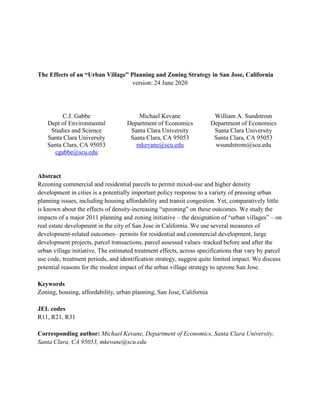
  • 17. 15 allowed as few as 2 commercial parcels per cluster, allowing for more residential-type agglomerations. As indicated in Figure 1 below, these “Synth Alt UVs” were decidedly less commercial in character than the actual urban villages, and thus perhaps a less comparable control group. These synthetic village control areas include certain neighborhood commercial zones that might have been obvious candidates for urban village designation but were not included: Willow Glen, parts of Meridian Avenue, and parts of Cambrian. It is possible that community opposition to higher density in these neighborhoods led to them not being included in the urban village process. Two other choices went into defining the universe of parcels included in the analysis. One choice was to exclude mobile homes from the analysis. Mobile homes and associated mobile home parks have complex characteristics in terms of their status as parcels. In the past, mobile homes could be considered as unsecured property that could be “rolled away” if the park were sold and developed. But increasingly, mobile home owners are considered by cities to be stakeholders in the development process, and city councils have been under pressure to grant permits for development of mobile home parks only if current mobile home residents are guaranteed affordable housing in the new development. Another issue concerns parcels that are not viable for their use code, as commercial or residential. Conversations with staff at the Santa Clara Assessor office suggested that numerous parcels in the city classified as commercial or multifamily might in reality have no economic value or prospects for development. These consist of odd shaped “leftover” or “cutout” parcels created during private development or public urban infrastructure work (streets, utilities). The Assessor Office apparently would give these parcels nominal values. The staff suggested that cutoffs of $50,000 for commercial and $20,000 for multifamily would capture these parcels, and no economically worthwhile parcel would have an assessor valuation lower than those numbers. Figure 1 displays the number of parcels in each of the groups outlined above. The urban village areas have about 1700 commercial parcels, and 2400 multi-family parcels, varying with the consistent parcel aggregation method. The two different “synthetic village” algorithms produce about 500 and 300 commercial and about 1000 and 2100 multifamily parcels, respectively. Recall the two have different algorithms, with the first designed to capture more commercial clusters and the second capturing many for multifamily parcel clusters. The “consistent 2019” method typically has the most plots for multifamily parcels, which as noted earlier is because the common pattern in development is the building of apartment blocks which are often assigned separate APN numbers, so that mechanically the hundreds of apartment blocks built over the decades mean the “final” number of parcels will be the largest (consistent parcels means these APN are aggregated back to their original larger parcel).
  • 18. 16 Figure 1: Numbers of parcels in various 'treatment or control' categories, for defined areas of San Jose 5. Results There are several hundred pre-post coefficients due to our outcome measures, selection of comparison areas, methods of measuring consistent parcels, generalized parcel use code
  • 19. 17 categories, and post time periods. Again, the four outcome measures are whether the parcel had a new construction permit over the time period, whether the parcel had an assessor revaluation or a sale transaction over the period, whether the parcel was the location of a major project, and the log of maximum assessor valuation over the period. There are 10 areas to be compared with each other (abbreviating urban village as UV and horizon as H): UV H1, UV H2, UV H3, UV H123 combined, UV adopted plans, UV not-yet-adopted plans, Specific Plan areas, synthetic village control areas (2 versions), and an “area” consisting of all other parcels in the city (called “All other”). The three different ways to track consistent parcels are labelled “Consistent 2019,” “Consistent 2005,” and “Consistent grouped parcels.” The two generalized use-codes for parcels are commercial or multi-family. The pre-period is always defined as the five years 2006-2010, and two alternative post-periods are considered: 2011-2015 and 2014-2019. Table 3 anticipates the regression analysis, showing that there was not much development activity happening in urban villages compared with the synthetic villages. Three of the outcome variables are coded as dummy variables: Was there an assessor revaluation or property transaction? Was there a permit for new construction? Was there a major project? Table 3 displays the counts for the positive outcomes for these variables, for two groups of parcels, the parcels comprising the urban villages (inclusive of all Horizons 1, 2, and 3), and the parcels comprising the synthetic villages. Separate columns for revaluations and transactions are provided, given the change in data availability over our period. As can be seen in the table, the number of positive values is quite sparse for the major projects and new construction permits for both the urban villages and synthetic villages. There was very little development in either of these areas.
  • 20. 18 Results from the regressions are displayed in four different sets of plots, Figures 2-5, each with 3 panels corresponding to the different ways of aggregating parcels. Each figure corresponds to a different outcome variable. Each panel displays 40 estimated coefficients (10 comparison groups of parcels, 2 use-codes, and 2 outcome periods). The plots are designed to provide a simple comparison of the change in mean outcomes between the pre-treatment and the post-treatment periods, across various categories of parcels. In each case, the dot and whiskers provide the point estimate and 95% confidence interval, respectively, for the coefficient βj in the following regression, for the relevant category j: Yijt = αj + βjDjt + μijt where i is the parcel or parcel group, t = 0,1 for the before and after periods respectively, Yijt is the outcome of interest for parcel i in
  • 21. 19 period t, and Djt is a dummy variable for the post-treatment period, equal to 1 if t = 1 and 0 otherwise. For the three outcome variables that are binary (dummies), the regressions estimate a linear probability model. The data set used in each regression has two observations per parcel: the value for the outcome for the parcel in 2005-10 and the value for the outcome for the parcel in the “post” period. The explanatory variable is a dummy variable for the post-period. We use a balanced panel for each regression; specifically, a parcel or parcel group must be represented in every year of both the pre and post periods. This procedure avoids potential selection problems arising from aggregating over different numbers of years for different parcels. Because we have tried to create consistent parcel or parcel group definitions over time, the balanced panels contain the large majority (typically about 97 percent) of the parcels present in the full unbalanced panel. A positive (negative) coefficient on the “post” dummy variable indicates that on average parcels in the category had higher (lower) values for the outcome in the “post” period. To interpret Figures 2-5, consider the upper left panel of Figure 2 which reports the outcome for whether there was a construction permit pulled for the parcel during the time period. The estimates are for commercial parcels, where consistent parcels are defined by the 2005 consistent method. The first row shows the change in the predicted probability of a permit being pulled for a parcel located in urban villages (regardless of Horizon, so including Horizons 1, 2, and 3), from the 2006-2010 period to the 2011-2015 period. Such parcels basically saw no change in the probability of a construction permit, on average. The point estimate is centered on zero and the confidence interval includes zero.6 The red vertical line represents the point estimate for the synthetic village control group of parcels (in the second row). As can be seen, these parcels saw the probability of permits decline by a small amount, about -.002, and the confidence interval also includes zero. In the same panel, the fourth row shows the estimated change for parcels not in any of the urban village or urban village-like groups (the “all other” group). These parcels also saw no change in permits. The confidence intervals suggest that most of the estimates cannot rule out the null hypothesis that there was no difference in the change in permits in urban villages compared with the other comparison groups, and within the urban village category the earlier Horizon parcels and the parcels in urban villages with approved plans, did not see significantly different changes in permits. Formal hypothesis tests for some of these comparisons are discussed below. The other panels in Figure 2 present the estimates for the same groups, but with different time periods and with multi-family instead of commercial parcels, and for different ways of creating consistent parcels. The “whiskers” that define the confidence interval of the point estimate vary because the different groups have different numbers of parcels and because there is different variation within the group. The Specific Plan group, which has a much smaller number of observations than other groups (only 150 commercial parcels), typically had the largest confidence interval. The “precisely” estimated zero effects for some of the regressions are an 6 Confidence intervals are plus or minus two standard errors, where all standard errors are heteroskedasticity-robust.
  • 22. 20 artifact of samples in which the dependent variable was 0 for all observations, as indicated in Table 3 above. We turn then to more discussion of each group of estimates noting some of the estimates of interest. The overall picture is that the urban village area had neither sizable nor significant effects, for the given outcome measures. Construction permit activity The outcome variable is a dummy variable equal to 1 if any new construction permit was issued for a parcel during the specified period. For the entire period 2005-19 this measure comes from the actual permit file provided by the City of San Jose. The upper left panel of Figure 2 was discussed above. Consider then another panel in the figure, the one which reports the outcome for the 2014-19 period for multi-family parcels using the consistent parcel groups or “large parcels” (the lower right panel). Recall that the “large” consistent parcel aggregates outcomes for all parcels that were linked by a split or merge at any time over the 2005-19 period. The first row shows the average change in the probability of a construction permit for parcels located in urban villages (regardless of Horizon, so including Horizons 1,2,and 3), from the 2006-2010 period to the 2014-2019 period. Such parcels saw the numbers of permits drop by a very small and statistically insignificant amount (the hypothesis that there was no decline cannot be rejected as the confidence interval extends beyond zero). The red vertical line represents the point estimate for the synthetic control group of parcels (in the second row). As can be seen, these parcels saw permits decline by about -.002, on average, and the confidence interval again includes zero. In the same panel, the fourth row shows the estimated change for parcels not in any of the urban village or urban village-like groups (the “all other” group). These parcels saw likewise essentially no change in the pace of permitting. Overall, the point estimates and confidence intervals indicate that the urban villages areas were not very different from the control areas, the Specific Plan areas, and the “all other” areas. The change in permit numbers were small, suggesting that the period after 2011 when the General Plan including the urban village was approved saw little increase in construction activity across the city. Urban villages were not significantly different (neither more nor fewer construction permits) compared to the rest of the city.
  • 23. 21 Figure 2: Coefficients and confidence intervals for regressions estimating change in whether parcel had a new construction permit pulled between pre and post periods, for defined areas of San Jose
  • 24. 22 Revaluations / transactions The outcome variable of transactions is a dummy variable for whether the parcel was revalued or transacted during the specified period. For 2014-19 this measure comes from the actual transaction file provided by the Assessor. For the pre period (2006-10) and the first post period (2011-15), we inferred transactions or development according to whether the annual assessed value increased by more than the typical 2% permissible by law, or the parcel was involved in a split or merger identified in the assessor’s crosswalk of parcel numbers (see Appendix B for more details on our process for coding assessor revaluations). Because property revaluations greater than 2% can occur for reasons other than sales (such as improvements that increased a structure’s square footage), the variables for revaluations and actual transactions are not strictly comparable. Consequently, the comparison between the 2006-10 pre-period and the 2014-19 post-period must be treated with some caution. In our view, there is little reason to think that the change in measurement would affect treated and untreated areas differentially, so we surmise that the comparison across coefficients should still be informative (i.e., the change should “differenced out”). Consider the middle left panel of Figure 3. The estimates are for commercial parcels, where consistent parcels are defined by the 2019 consistent method. The first row shows the average change in whether a parcel experienced a revaluation for parcels located in urban villages (regardless of Horizon, so including Horizons 1, 2, and 3), from the 2006-2010 period to the 2011-2015 period. Such parcels saw essentially no change in this variable, on average. The red vertical line represents the point estimate for the synthetic village control group of parcels (in the second row). As can be seen, these parcels saw the probability of a revaluation decline by about -.05. The “all other” group parcels saw a somewhat larger decline in whether a parcel transacted, -.09. The confidence intervals suggest that most of the estimates (except for the “all other”) overlap (and formal hypothesis tests confirm this). Consider then another panel in Figure 3, the one which reports the outcome for the 2014- 19 period for multi-family parcels using the consistent grouped parcels (the lowest right panel). The change in the probability of a transaction for parcels located in urban villages (regardless of Horizon, so including Horizons 1, 2, and 3), from the 2006-2010 period to the 2014-2019 period was estimated to be a decline of about -0.18, on average. The red vertical line represents the point estimate for the synthetic village group of parcels (in the second row). As can be seen, these parcels saw a zero change in the probability of a transaction.
  • 25. 23 Figure 3: Coefficients and confidence intervals for regressions estimating change in whether parcel underwent an assessor revaluation or transaction between pre and post periods, for defined areas of San Jose
  • 26. 24 Overall, the confidence intervals indicate that for commercial parcels the urban villages and synthetic village areas were quite similar for the change to the 2011-15 period, but the “all others” and specific plan areas saw fewer transactions in the 2014-19 period. For multi-family parcels the pattern was quite different, with the urban village areas seeing declines in transactions relative to smaller declines for the synthetic village areas. The Specific Plan areas of the city saw even larger declines. The evidence is mixed, then, as to whether the urban villages saw more real estate transactions: perhaps more commercial transactions and fewer multi-family transactions. Major projects Figure 4 reports the outcome for a dummy variable equal to 1 if the parcel had a major project during the relevant period. Each year, San Jose city staff compile a list of “major projects” that is reported to the City Council, as noted above. Occasionally some projects are built in phases, and so a parcel might have two major projects over a five year period. In all cases, we assign the first year the major project appears on the list (usually in the category “under consideration” or “permit pending”) as the “date” of the project. The reports will repeat many projects as they go through phases of approved permits, beginning construction, and completed construction. The data from these reports is turned into an outcome variable of whether there was a major project for a parcel for the specified period. The estimates in Figure 4 for multi-family parcels all include zero in the confidence intervals (except for H2 in the large consistent parcel aggregation where the confidence interval is large and below zero). Precise zeroes again occur when none of the parcels in the relevant area had a major project (see Table 3 above). Overall there were few major projects relative to the number of parcels, and major projects were initiated and built over decade-long horizons. So the null hypothesis that there is no change in the number of major projects over various five year periods was unlikely to be rejected. For commercial parcels, the estimates have wider confidence intervals, and again almost all include zero. There is no evidence, then, that urban villages saw more major projects than other areas in the periods after the 2011 General Plan was adopted.
  • 27. 25 Figure 4: Coefficients and confidence intervals for regressions estimating change in whether parcel had a major project between pre and post periods, for defined areas of San Jose
  • 28. 26 Assessor valuation For property values, we define the value for the five-year span as the maximum assessed value of that parcel across the five years of data; in most cases this will be the value of the parcel in the last year of the period, as overall values were rising over time. Using the mean value over the five years does not substantially alter the results. We take the natural log of the value. The estimated coefficients presented in Figure 5 are then interpreted as approximately the proportional change in the value between the pre and post periods. Mechanically, because most assessed values rise automatically at 2% per year, we should expect positive coefficients in Figure 5 for most of the areas. Since the average values of parcels are on the order of $1 million, 2% over five years corresponds to increases of about $100,000 in assessed value, and the default change from the 2005-10 period to the 2014-19 period would be about double that, or $200,000. Indeed, the estimated coefficients for that “post” period are always larger, and sometimes significantly different from zero. For commercial parcels (the panels on the left), there appears to be no difference in the change in valuation for urban villages compared to the control areas. For multi-family parcels, when comparing the 2014-19 period with the 2005-10 period, the assessed valuation of the urban village parcels increased by somewhat less than the synthetic village control areas. The confidence intervals overlap somewhat however and so the differences are not statistically significant.
  • 29. 27 Figure 5: Coefficients and confidence intervals for regressions estimating change log of maximum assessor valuation between pre and post periods, for defined areas of San Jose
  • 30. 28 Overall assessment of impact of urban villages It should be borne in mind that comparisons of the estimates and intervals across the categories are illustrative but do not generally constitute formal hypothesis tests of differences in the coefficients, because most of the comparisons are not nested, and the treatment categories being compared are not all mutually exclusive. For a formal hypothesis test of whether the “post” coefficient for treated parcels is the same as that for control parcels, we can pool the samples from the relevant treatment and control areas and estimate the standard DD interaction term between the dummy variables for post and treated category. A positive coefficient would indicate that the outcome variable increased by more (or decreased by less) in treated parcels than in control parcels. We focus here on two sets of comparisons: treated parcels in urban villages of any Horizon (1, 2, or 3) against control parcels in synthetic villages; and treated parcels in Horizon 1 urban villages against control parcels in Horizon 2 or 3 urban villages. For these two treatment regimes, we estimated and conducted the test of the DD coefficient for each of the four key outcome variables discussed above, for commercial and multi-family parcels, and for the earlier (2006-2011) and later (2014-2019) post periods. These permutations result in 32 coefficient estimates, which we estimated for each of our three methods of forming consistent parcel samples across time. The results are available in a table in Appendix D. In each case, of the 32 estimated coefficients, only 2 or 3 had p-values below 0.05.7 Given multiple comparisons, this seems little better than random. The evidence of impact is at best mixed. There are a few cases where urban villages have “significantly” different outcomes from comparison groups. The differences are small however. The variety of differences illustrates the “garden of forking paths” dimension to econometrics: there are numerous ways to create consistent parcels that can be used to estimate impact analysis, numerous ways to define treatment and control groups, and numerous alternative outcomes to examine. Many published papers in this field do not, however, report the exact procedures used to create parcel samples, nor do they examine the robustness of their estimates to alternative aggregation procedures. Pre-trend checks The difference-in-difference strategy for estimating treatment effects relies on a crucial assumption that the treated and control groups would have had similar counterfactual experiences (in terms of the outcomes) if there had been no urban village strategy, and thus share a common trend. This assumption is not testable, but an informal approach that has become standard practice is to check the “pre-trend” behavior of the outcome variables. To do this, we estimate and plot the interaction between the treatment group dummy and individual year effects. 7 The coefficients that are consistently significant by a standard test are those for revaluations/ transactions in multi- family parcels, comparing urban villages and synthetic villages. These coefficients are negative.
  • 31. 29 A visible trend in this treatment-control differential prior to the treatment event horizon (in our case, 2011) would suggest differential pre-trends, violating the common trends assumption. Figure 6 presents these plots for two of our treatment variables: the revaluation/ transaction dummy and the log of assessed value, respectively. Plots for the construction permit and major project interactions are uninformative at annual frequency, given the sparseness of these events in our samples (see Table 3). As can be seen in the left column, the treatment effects for revaluation probabilities in multi-family parcels appear to exhibit a downward pre-trend in the years leading up to 2011. This suggests that the significant negative DD effect of urban villages on transactions of multi- family parcels in our pre-post comparison should be taken with a grain of salt. It may be that for reasons unrelated to the urban village plan, transactions were already declining more quickly or increasing less quickly in what would become urban village areas relative to similar synthetic villages. The right column of Figure 6 repeats the exercise for the log of assessed value. Clearly, no differential trends or significant differences between treated and untreated parcels are evident.
  • 32. 30 Figure 6: Pre-trend graphs of estimates of the interaction of year with treatment category using annual data, comparing revaluations or transactions (left column) and log of assessed value (right column) in urban village H123 parcels with synthetic villages.
  • 33. 31 Conclusion Political leaders and ordinary residents of San Jose, as in other cities, believe that the housing crisis in growing metropolitan areas necessitates significant changes in the set of policies that shape the extent and nature of the private and public provision of housing. Upzoning has been a preferred strategy of many cities. The analysis presented in this paper describes and estimates the impact of San Jose’s urban village strategy. The urban village strategy was adopted in 2011, and involved designating 68 areas for upzoning. The first contribution of this paper is to present empirical estimates of impact that suggest that urban villages did not lead to significantly more development in the eight years following the adoption of the strategy. We used several measures of development-related outcomes: construction permits, transactions, changes in assessor property valuations, and major projects. Since many of the measures have measurement error, we believe that triangulating multiple indicators may be a better approach than focusing on a single indicator. The estimation strategy adopted in this paper was to compare outcomes in zones designated as urban villages with comparable zones (with different designations or later designations) that serve as appropriate controls or counterfactuals. Since urban village designation was not random and may have responded to characteristics of the zones themselves, the effects of urban village designation are estimated through a difference-in-difference strategy, where the change in outcomes in urban villages, from the period prior to designation to the recently available time period (including possible changes in trends of outcomes), are compared with the changes (or changes in trends) for the control group (for which there are two possibilities: urban villages whose implementation was delayed, or “synthetic” urban villages created through a simple algorithm). The urban villages areas were not randomly selected from all possible areas with commercial zoning. The city council and general plan team sought to spread urban villages throughout the city, encourage development near existing transportation infrastructure, and designate an urban village within walking distance of most city residents. Because there was considerable endogeneity in the designation of zones as urban villages and the assignment of Horizons to the 68 urban village areas, most estimation strategies will generate biased estimates of the impact of urban village designation. This is the significant methodological challenge of estimating impacts in complex urban planning environments. This caution applies to anecdotal and expert evaluations of the impact of urban villages as well as to quantitative evaluations. Anecdotal and expert evaluations may be, however, prone to other sorts of bias in both assessment and interpretation, as imprecision in measurement, unclear sample selection, salience bias, and unstated assumptions permit wide latitude for drawing conclusions. Our main quantitative findings that the urban villages saw little development, using reasonable comparison areas as the counterfactuals, are largely in agreement with some expert assessments. A report by SPUR, an influential urban planning advocacy group, contributing to the 2019 public process of revising the General Plan noted that: “SPUR consistently heard in interviews that developers are actively avoiding urban villages and instead seeking out opportunities downtown, in North San Jose or in other cities such as Santa Clara, Sunnyvale,
  • 34. 32 Mountain View and Redwood City. Many have given feedback that it is the urban village framework and process, rather than the locations or the real estate market, that are the biggest deterrents…. Unfortunately, the seven most recent urban village plans took, on average, four to four and a half years to complete, far exceeding the current goal of one year. In addition, the plans themselves do not provide any streamlining or improvements to the approvals or permitting process” (Wang, 2019). Expert analysis also points to other reasons why there was little impact of the urban village strategy. The efficacy of upzoning in leading to residential development and changes in the affordability of housing is likely to vary according to general conditions of the profitability of development. It has not been clear that residential housing development in San José (with high sale prices) has been more or less profitable than in other metropolitan areas (with low sales prices). Consider the analysis of market conditions for high-density apartments in San Jose by Keyser Marston & Associates (KMA) conducted for the San José City Council and presented at a council study session on the city’s residential housing strategy in April 2018 (City of San Jose, 2018). The report presented estimates of per-unit project value and project cost for 10 prototypical developments across five San José sub-regions: downtown core, North San Jose, West San Jose, Central San Jose, and South/East San José. Each region was paired to a project type, ranging from 20-25 floor high-rises (downtown), to 7-floor mid-rise (West, North, Central) and 5-floor low-rise buildings (South/East). For each sub-region, projects had their development values estimated based on average rents of real, adjacent properties. For example, average rents ranged from a per-unit value of $2,750 in South/East San José to $3,450 in West San José (Stevens Creek). KMA estimated the cost of development including land costs, city fees (affordable housing fees, park fees, permits, etc.), and construction costs. Profit margins were estimated by subtracting per-unit development costs from per-unit values. According to KMA, only the Central San José and West San José development projects had positive profit margins (3% and 19%, respectively). The second contribution of the paper is methodological. We have tried to be transparent about two methodological points that are essential complements to analysis of urban planning strategies. The first is that there are several choices for constructing consistent panel data on urban development. Depending on the nature and rapidity of development, different choices may generate different impact estimates. As we have seen, three alternatives could be carried out, at a minimum: using the initial parcel set as the sample; using the final parcel set as the sample; and using the set of smallest consistent parcel groups as the sample. For San Jose, the choices were largely congruent in their estimates, but there is no theoretical reason why they have to generate impact estimates of similar magnitude. The second methodological point is that there are numerous interesting and relevant outcome variables, and a “garden of forking paths” emerges in the many decisions researchers have to take to construct variables (Gelman & Loken, 2014). The question of permits is instructive: the city’s database of permits includes permits of many types, and distinguishing among them is quite difficult, involving many choices. Should permits to repair building faults
  • 35. 33 identified by inspectors be treated as “development” or be excluded? Are permits to re-roof to be grouped with permits for new construction? Moreover, multiple outcome measures and definitions raise flags of multiple testing problems: it is well-established that researchers are biased by the professional value of “statistical significance” and decisions about when to “stop” data analysis are asymmetric: null findings prompt more analysis, significant findings dull the incentives for more analysis. Researchers should endeavour to make data available upon request so that other researchers can examine the robustness of findings to alternative definitions and specifications. The appendices to the paper discuss in considerable detail the many choices made, and R code for the analysis is available. A final contribution of this paper is to discuss in detail what the “urban villages” strategy actually entailed, and suggest some improvements for cities and voters considering similar strategies. The description of the urban village strategy makes clear that it was not a simple upzoning. The process of approving urban village plans, adopting a framework for the upzoning process, and facilitating community engagement throughout the process proved cumbersome. By 2019, only a fifth of the 68 proposed urban villages had approved plans. We conclude with the caution that while there are significant challenges to data-based econometric analysis of the impact of urban village and similar urban planning strategies, these analyses should be included in public discussion of the success or failure of urban planning strategies, which perhaps too often are guided by selective and salient anecdotes about particular development projects or other outcomes.
  • 36. 34 Acknowledgments We thank Gregory Iturria at the Santa Clara County Office of Budget and Analysis, and Larry Stone, Greg Monteverde, Jeff Kwan, and Tess Manesis at the Santa Clara County Assessor office for assistance in providing data and answering questions about the data. Michael Lane was helpful in helping understand housing development issues in San Jose. We are grateful to seminar participants at Santa Clara University Department of Economics. Research assistants Katie Moran, Owen Gilles, and Julie Vass appeared to enjoy some of the intensive and tedious data wrangling aspects of the research. We gratefully acknowledge financial support from the Leavey School of Business at Santa Clara University. Funding This research did not receive any specific grant from funding agencies in the public, commercial, or not-for-profit sectors Author statement All authors contributed equally to the conceptualization, data gathering, analysis, and writing of the paper. Data statement The data used for the analysis in the paper is a combination of publicly available data taken from City of San Jose websites and of purchased data from the Santa Clara County Assessor Office. Data from the Assessor Office is restricted. The authors are happy to work with the Assessor Office to determine if the data can be made available for replication studies, should the paper be accepted for publication. Tables and Figures In the present version, tables and figures are placed in the text when they would appear. Tables are placed as images in order to fit sizing of page. In a final manuscript, tables will be supplied as editable text, and figures as grayscale JPEG images at 300 dpi (or other format). Figures have been created in R.
  • 37. 35 References Angotti, T. (2017). Zoned out! Race, displacement, and city planning in New York City. In Zoned Out! Race, Displacement, and City Planning in New York City. Urban Research. https://www.urpub.org/books/zonedout Atkinson-Palombo, C. (2010). Comparing the capitalisation benefits of light-rail transit and overlay zoning for single-family houses and condos by neighbourhood type in metropolitan Phoenix, Arizona. Urban Studies, 47(11), 2409–2426. https://doi.org/10.1177/0042098009357963 Been, V., Madar, J., & McDonnell, S. (2014). Urban land-use regulation: Are homevoters overtaking the growth machine? Journal of Empirical Legal Studies, 11(2), 227–265. https://doi.org/10.1111/jels.12040 Bowes, D. R., & Ihlanfeldt, K. R. (2001). Identifying the impacts of rail transit stations on residential property values. Journal of Urban Economics, 50(1), 1–25. https://doi.org/10.1006/juec.2001.2214 California LAO. (2012). Understanding California’s property taxes. California Legislative Analyst’s Office. https://lao.ca.gov/reports/2012/tax/property-tax-primer-112912.aspx City of San Jose. (n.d.). Specific plans. San Jose Planning, Building and Code Enforcement. Retrieved June 20, 2019, from http://www.sanjoseca.gov/index.aspx?NID=1741 City of San Jose. (2011). Envision San Jose 2040 General Plan. City of San Jose. https://www.sanjoseca.gov/your-government/departments/planning-building-code- enforcement/planning-division/citywide-planning/envision-san-jos-2040-general-plan City of San Jose. (2018). Urban village implementation and amenity framework. City of San Jose. https://www.sanjoseca.gov/home/showdocument?id=38415 City of San Jose. (2019). General plan 4-year review task force meeting #2. https://www.sanjoseca.gov/home/showdocument?id=49314 City of San Jose. (2020a). Development activity highlights and five-year forecast (2021-2025). City of San Jose Department of Planning, Building and Code Enforcement. https://www.sanjoseca.gov/home/showdocument?id=54320 City of San Jose. (2020b). GIS spatial data downloads. San Jose Planning, Building and Code Enforcement. https://www.sanjoseca.gov/your-government/departments-offices/public- works/resources/gis-data-downloads City of San Jose. (2020c). Task force meeting no. 3 synopsis. https://www.sanjoseca.gov/home/showdocument?id=53843 City of Seattle. (2017). Seattle 2035. City of Seattle. http://www.seattle.gov/Documents/Departments/OPCD/OngoingInitiatives/SeattlesComprehensiv ePlan/CouncilAdopted2017_CitywidePlanning.pdf Coiacetto, E. (2009). Industry structure in real estate development: Is city building competitive? Urban Policy and Research, 27(2), 117–135. https://doi.org/10.1080/08111140802499080 Cosman, J., & Quintero, L. (2019). Market concentration in homebuilding. Carey Business School, Johns Hopkins University. https://docs.wixstatic.com/ugd/5fcb6a_38293a75ef124a238571b148b9ddbf69.pdf County of Santa Clara. (n.d.). Understanding Proposition 13. Office of the Assessor, County of Santa Clara. https://www.sccassessor.org/index.php/faq/understanding-proposition-13 Cullingworth, J. B. (1993). The political culture of planning: American land use planning in comparative perspective. Routledge.
  • 38. 36 Cunningham, C. R. (2006). House price uncertainty, timing of development, and vacant land prices: Evidence for real options in Seattle. Journal of Urban Economics, 59(1), 1–31. https://doi.org/10.1016/j.jue.2005.08.003 Cunningham, C. R. (2007). Growth controls, real options, and land development. The Review of Economics and Statistics, 89(2), 343–358. https://doi.org/10.1162/rest.89.2.343 Erdmann, K., Furth, S., & Hamilton, E. (2019). The link between local zoning policy and housing affordability in America’s cities. Mercatus Center, George Mason University. https://www.mercatus.org/system/files/erdmann_hamilton_and_furth_-_policy_brief_- _land_use_regulations_and_how_they_create_closed_access_cities_-_v1.pdf Fischel, W. A. (1987). The economics of zoning laws: A property rights approach to American land use controls. JHU Press. Fischel, W. A. (2005). The homevoter hypothesis: How home values influence local government taxation, school finance, and land-use policies. Harvard University Press. Freemark, Y. (2019). Upzoning Chicago: Impacts of a zoning reform on property values and housing construction. Urban Affairs Review, Advance online publication. https://journals.sagepub.com/doi/abs/10.1177/1078087418824672 Gabbe, C. J. (2018). Why are regulations changed? A parcel analysis of upzoning in Los Angeles. Journal of Planning Education and Research, 38(3), 289–300. https://doi.org/10.1177/0739456X17696034 Gabbe, C. J. (2019). Local regulatory responses during a regional housing shortage: An analysis of rezonings in Silicon Valley. Land Use Policy, 80, 79–87. https://doi.org/10.1016/j.landusepol.2018.09.035 Gabbe, C. J., Pierce, G., & Clowers, G. (2020). Parking policy: The effects of residential minimum parking requirements in Seattle. Land Use Policy, 91. https://doi.org/10.1016/j.landusepol.2019.104053 Gelman, A., & Loken, E. (2014). The statistical crisis in science: Data-dependent analysis—A" garden of forking paths"—Explains why many statistically significant comparisons don’t hold up. American Scientist, 102(6), 460–466. Glaeser, E., & Gyourko, J. (2018). The economic implications of housing supply. Journal of Economic Perspectives, 32(1), 3–30. https://doi.org/10.1257/jep.32.1.3 Glaeser, E. L., Gyourko, J., & Saks, R. (2005). Why is Manhattan so expensive? Regulation and the rise in housing prices. The Journal of Law and Economics, 48(2), 331–369. https://doi.org/10.1086/429979 Hilber, C. A., & Vermeulen, W. (2015). The impact of supply constraints on house prices in England. The Economic Journal, 126(591), 358–405. https://doi.org/10.1111/ecoj.12213 Hirt, S. A. (2015). Zoned in the USA: The origins and implications of American land-use regulation. Cornell University Press. Hsieh, C.-T., & Moretti, E. (2019). Housing constraints and spatial misallocation. American Economic Journal: Macroeconomics, 11(2), 1–39. https://doi.org/10.1257/mac.20170388 Ihlanfeldt, K. R. (2007). The effect of land use regulation on housing and land prices. Journal of Urban Economics, 61(3), 420–435. https://doi.org/10.1016/j.jue.2006.09.003 Jackson, K. (2016). Do land use regulations stifle residential development? Evidence from California cities. Journal of Urban Economics, 91, 45–56. https://doi.org/10.1016/j.jue.2015.11.004 Kahn, M. E. (2007). Gentrification trends in new transit-oriented communities: Evidence from 14 cities
  • 39. 37 that expanded and built rail transit systems. Real Estate Economics, 35(2), 155–182. https://doi.org/10.1111/j.1540-6229.2007.00186.x Karlinsky, S., Szambelan, S. J., & Wang, K. (2017). Room for more. SPUR. https://www.spur.org/sites/default/files/publications_pdfs/SPUR_Room_for_More_print.pdf Kendall, R., & Tulip, P. (2018). The effect of zoning on housing prices (Reserve Bank of Australia Research Discussion Paper No. 2018–03). Reserve Bank of Australia. https://ssrn.com/abstract=3149272 Kok, N., Monkkonen, P., & Quigley, J. M. (2014). Land use regulations and the value of land and housing: An intra-metropolitan analysis. Journal of Urban Economics, 81, 136–148. https://doi.org/10.1016/j.jue.2014.03.004 Krause, A. (2014). Urban intensification in Seattle: A data system, policy evaluation and market analysis [PhD Dissertation, University of Washington]. https://digital.lib.washington.edu/researchworks/handle/1773/25055 Krause, A., & Lipscomb, C. A. (2016). The data preparation process in real estate: Guidance and review. Journal of Real Estate Practice and Education, 19(1), 15–42. https://doi.org/10.5555/1521- 4842.19.1.15 Lewis, P. G. (2001). Retail politics: Local sales taxes and the fiscalization of land use. Economic Development Quarterly, 15(1), 21–35. https://doi.org/10.1177/089124240101500102 Liccardo, S. (2017). Responding to the housing crisis [Memorandum to Rules and Open Government Committee]. City of San Jose. http://sanjose.granicus.com/MetaViewer.php?meta_id=667033 Lin, D., & Wachter, S. M. (2019). Land use regulation on housing prices. https://ssrn.com/abstract=3363947 Matthews, J. W., & Turnbull, G. K. (2007). Neighborhood street layout and property value: The interaction of accessibility and land use mix. The Journal of Real Estate Finance and Economics, 35(2), 111–141. https://doi-org/10.1007/s11146-007-9035-9 Meck, S., Wack, P., & Zimet, M. J. (2000). Zoning and subdivision regulations. In The practice of local government planning (pp. 343–374). International City/County Management Association. Metcalf, G. (2018). Sand castles before the tide? Affordable housing in expensive cities. Journal of Economic Perspectives, 32(1), 59–80. https://doi.org/10.1257/jep.32.1.59 Misczynski, D. J. (1986). The fiscalization of land use. California Policy Choices, 3, 127–50. Molotch, H. (1976). The city as a growth machine: Toward a political economy of place. American Journal of Sociology, 82(2), 309–332. https://doi.org/10.1086/226311 Neumark, D., & Kolko, J. (2010). Do enterprise zones create jobs? Evidence from California’s enterprise zone program. Journal of Urban Economics, 68(1), 1–19. https://doi.org/10.1016/j.jue.2010.01.002 Paulsen, K. (2014). The effects of land development on municipal finance. Journal of Planning Literature, 29(1), 20–40. https://doi.org/10.1177/0885412213497982 Pendall, R. (2000). Local land use regulation and the chain of exclusion. Journal of the American Planning Association, 66(2), 125–142. https://doi-org/10.1080/01944360008976094 Pollakowski, H. O., & Wachter, S. M. (1990). The effects of land-use constraints on housing prices. Land Economics, 66(3), 315–324. JSTOR. https://doi-org/10.2307/3146732 Quigley, J. M., & Raphael, S. (2005). Regulation and the high cost of housing in California. American Economic Review, 95(2), 323–328. https://doi-org/10.1257/000282805774670293 Quigley, J. M., & Rosenthal, L. A. (2005). The effects of land use regulation on the price of housing:
  • 40. 38 What do we know? What can we learn? Cityscape, 8(1), 69–137. Raetz, H., Forscher, T., Kneebone, E., & Reid, C. (2020). The hard costs of construction: Recent trends in labor and materials costs for apartment buildings in California. UC Berkeley Terner Center for Housing Innovation. http://ternercenter.berkeley.edu/uploads/Hard_Construction_Costs_March_2020.pdf Reid, C. (2020). The costs of affordable housing production: Insights from California’s 9% low-income housing tax credit program. UC Berkeley Terner Center for Housing Innovation. http://ternercenter.berkeley.edu/uploads/LIHTC_Construction_Costs_March_2020.pdf Rodríguez-Pose, A., & Storper, M. (2019). Housing, urban growth and inequalities: The limits to deregulation and upzoning in reducing economic and spatial inequality (CEPR Discussion Paper No. DP13713). https://papers.ssrn.com/sol3/papers.cfm?abstract_id=3383971 Sage, A., Langen, M., & Van de Minne, A. (2019). Where Is the opportunity in Opportunity Zones? Early indicators of the Opportunity Zone program’s impact on commercial property prices. SSRN. https://papers.ssrn.com/sol3/papers.cfm?abstract_id=3385502 Saiz, A. (2010). The geographic determinants of housing supply. The Quarterly Journal of Economics, 125(3), 1253–1296. State of California. (2001). The planner’s guide to specific plans. Governor’s Office of Planning and Research. https://www.ca-ilg.org/sites/main/files/file- attachments/resources__specific_plans_0.pdf?1350954879 State of California. (2017). General plan guidelines. Governor’s Office of Planning and Research. http://www.opr.ca.gov/docs/OPR_COMPLETE_7.31.17.pdf State of California. (2020). California Consumer Price Index. State of California Department of Industrial Relations. https://www.dir.ca.gov/OPRL/CAPriceIndex.htm Svensson, D. (2015). Fiscal analysis. Applied Development Economics for the City of San Jose. https://www.sanjoseca.gov/home/showdocument?id=22533 Szambelan, S. J., Terplan, E., & Brownstein, B. (2016). Back in the black. SPUR. https://www.spur.org/sites/default/files/publications_pdfs/SPUR_Back_in_the_Black.pdf Toeniskoetter, L. (2011, November 18). “New Blueprint of a City: San Jose’s 2040 General Plan.” https://www.spur.org/news/2011-11-18/new-blueprint-city-san-joses-2040-general-plan November 18, 2011 U.S. Census Bureau. (2018). 2018 American Community Survey 1-year estimates. U.S. Bureau of the Census. Wang, K. (2019). It takes a village: Strategies for successful implementation of San Jose’s urban village vision. SPUR. https://www.spur.org/sites/default/files/publications_pdfs/SPUR_It_Takes_a_Village.pdf Wassmer, R. W. (2002). Fiscalisation of land use, urban growth boundaries and non-central retail sprawl in the western United States. Urban Studies, 39(8), 1307–1327. Whittemore, A. H. (2017). Racial and class bias in zoning: Rezonings involving heavy commercial and industrial land use in Durham (NC), 1945–2014. Journal of the American Planning Association, 83(3), 235–248. https://doi-org/10.1080/01944363.2017.1320949 Wissoker, P. (2016). Putting the supplier in housing supply: An overview of the growth and concentration of large homebuilders in the United States (1990–2007). Housing Policy Debate, 26(3), 536–562. https://doi.org/10.1080/10511482.2015.1115418