![What is a city? 2
There is thus a clear need to have sound and timely data
and metrics for the Sustainable Development Goals to be
met. Installation of effective and efficient systems for data
collection, collation, analysis and sharing will enable cities to
make correct decisions on the best policies to adopt, and assist
in tracking changes, whilst systematically documenting their
performance. This is fundamental for attainment of enhanced
urban prosperity as well sustainable urban development for
all.
But what exactly is a city or an urban area? What is the
size threshold for an area to qualify as a city? What type of
administrative, legal or historical status defines a city ? How
do we distinguish an urban area from a town or a village?
A study of the city as a unit of analysis is critical to overcoming
future challenges and for better positioning of cities as engines
of national development. A concrete guidance on definitions,
measurements, and unified standards is necessary to make
sure that we work with harmonized and mutually agreed
concepts. However, these concepts and related monitoring
approaches should not aim at changing existing administrative
and statistical definitions in countries, but to adopt a functional
set of monitoring methods that are pragmatic, cost-effective,
simple and accurate. These changes could be made at a
‘supra-national’ level as guiding principles, and related metrics
developed that can provide data consistency and serve at the
same time as a global and regional platform for comparability.
When a country measures basic needs, the provision of
public goods, tangible and intangible assets, urban risks
and conditions for its cities, it needs to be sure these
measurements are similar and comparable to those of other
cities. Today’s diversity of definitions on what constitutes an
urban area, multiplicity of official concepts on how to delineate
the extent and conditions of cities, and array of measurement
techniques, have made it difficult to have internationally
validated city-specific data and information needed to define
what exactly constitutes progress or lack of it. This has further
made it hard to develop sound systems required to aggregate
values at the regional and global levels; broadly compromising
the monitoring and reporting on SDGs.
The city, one of the world’s biggest phenomenon of the 21st
century has evolved greatly over the centuries, particularly in
terms of its size, form, structure and composition, while largely
maintaining its importance in local and regional development.
In just 65 years, the world has experienced a population shift
from rural to urban, as witnessed by an increase in the global
population living in urban areas from 29.6% in 1950 to 54% in
2015.[1]
Estimates indicate that at the close of the monitoring
period for the sustainable development goals in 2030, 60%
of the world population will be urban.[2]
In absolute numbers,
between 1990 and 2000, global urban population is estimated
to have increased by an average of 57 million people per year;
a number that further increased to 77 million per year between
2010 and 2015.[3]
Cities have become a positive and potent force for addressing
sustainable economic growth, development and prosperity.
They drive innovation, consumption and investment in both
developed and developing countries.[4]
Cities are productive
systems through which most of the 21st century challenges
such as poverty, inequality, unemployment, environmental
degradation, and climate change can be addressed. Owing
to their unique character of population and investment
agglomeration, cities link the economic, energy, environment,
science, technology and social and economic elements of
development, all of which constitute the key interrelations
needed to formulate integrated policies required to achieve
sustainable development. Working at the urban level, it is
possible to include people, locations and city conditions
to ensure that no one – and no place – is left behind. This
makes cities an important string that connects all Sustainable
Development Goals.
Despite the unique opportunities presented by cities, their
being does not guarantee success towards sustainability, as
it in the same places where most of the above-mentioned
human settlements’ challenges are manifested. Equally, cities
do not always perform well, meaning that an action designed
to address a certain goal (e.g solve a major urban challenge)
does not always yield the desired results. In most cases,
lack of well informed decisions contributes to this, which is
itself partly a result of lack of a clear understanding of the
underlying needs or the implication of such decisions. This is
directly reliant on availability of reliable and up to date data.
1. BACKGROUND](data:image/gif;base64,R0lGODlhAQABAIAAAAAAAP///yH5BAEAAAAALAAAAAABAAEAAAIBRAA7)
Recommended
Recommended
More Related Content
Similar to Understanding the Complex Definitions of Cities
Similar to Understanding the Complex Definitions of Cities (20)
Recently uploaded
Recently uploaded (20)
Understanding the Complex Definitions of Cities
- 1. WHAT IS A CITY?
- 2. What is a city? 2 There is thus a clear need to have sound and timely data and metrics for the Sustainable Development Goals to be met. Installation of effective and efficient systems for data collection, collation, analysis and sharing will enable cities to make correct decisions on the best policies to adopt, and assist in tracking changes, whilst systematically documenting their performance. This is fundamental for attainment of enhanced urban prosperity as well sustainable urban development for all. But what exactly is a city or an urban area? What is the size threshold for an area to qualify as a city? What type of administrative, legal or historical status defines a city ? How do we distinguish an urban area from a town or a village? A study of the city as a unit of analysis is critical to overcoming future challenges and for better positioning of cities as engines of national development. A concrete guidance on definitions, measurements, and unified standards is necessary to make sure that we work with harmonized and mutually agreed concepts. However, these concepts and related monitoring approaches should not aim at changing existing administrative and statistical definitions in countries, but to adopt a functional set of monitoring methods that are pragmatic, cost-effective, simple and accurate. These changes could be made at a ‘supra-national’ level as guiding principles, and related metrics developed that can provide data consistency and serve at the same time as a global and regional platform for comparability. When a country measures basic needs, the provision of public goods, tangible and intangible assets, urban risks and conditions for its cities, it needs to be sure these measurements are similar and comparable to those of other cities. Today’s diversity of definitions on what constitutes an urban area, multiplicity of official concepts on how to delineate the extent and conditions of cities, and array of measurement techniques, have made it difficult to have internationally validated city-specific data and information needed to define what exactly constitutes progress or lack of it. This has further made it hard to develop sound systems required to aggregate values at the regional and global levels; broadly compromising the monitoring and reporting on SDGs. The city, one of the world’s biggest phenomenon of the 21st century has evolved greatly over the centuries, particularly in terms of its size, form, structure and composition, while largely maintaining its importance in local and regional development. In just 65 years, the world has experienced a population shift from rural to urban, as witnessed by an increase in the global population living in urban areas from 29.6% in 1950 to 54% in 2015.[1] Estimates indicate that at the close of the monitoring period for the sustainable development goals in 2030, 60% of the world population will be urban.[2] In absolute numbers, between 1990 and 2000, global urban population is estimated to have increased by an average of 57 million people per year; a number that further increased to 77 million per year between 2010 and 2015.[3] Cities have become a positive and potent force for addressing sustainable economic growth, development and prosperity. They drive innovation, consumption and investment in both developed and developing countries.[4] Cities are productive systems through which most of the 21st century challenges such as poverty, inequality, unemployment, environmental degradation, and climate change can be addressed. Owing to their unique character of population and investment agglomeration, cities link the economic, energy, environment, science, technology and social and economic elements of development, all of which constitute the key interrelations needed to formulate integrated policies required to achieve sustainable development. Working at the urban level, it is possible to include people, locations and city conditions to ensure that no one – and no place – is left behind. This makes cities an important string that connects all Sustainable Development Goals. Despite the unique opportunities presented by cities, their being does not guarantee success towards sustainability, as it in the same places where most of the above-mentioned human settlements’ challenges are manifested. Equally, cities do not always perform well, meaning that an action designed to address a certain goal (e.g solve a major urban challenge) does not always yield the desired results. In most cases, lack of well informed decisions contributes to this, which is itself partly a result of lack of a clear understanding of the underlying needs or the implication of such decisions. This is directly reliant on availability of reliable and up to date data. 1. BACKGROUND
- 3. What is a city? 3 The uniqueness of urban form, the fragmented and interstitial fabric of cities, the spatial and functional blur between urban and rural areas, as well as complex growth trends that generate diverse patterns and conditions have made it difficult to delimit city expanses, and coin a single and that is universally applicable definition. Currently, many diverse definitions exist, which vary between countries and regions. These definitions range from those using a single criteria (e.g population threshold) to those using a mix of criteria (e.g combination of population size, density, administrative delimitation, economic occupation etc). The use of such varied definitions and mix of criteria (some of which are not compatible) make it difficult to aggregate values in a consistent manner. Equally, the term city is used interchangeably with other concepts such as city proper, urban area, urban agglomeration, metropolitan area, among others, further complicating the process of attaining a single definition. These concepts are different not only in the method of analysis, but also in the territorial scale they cover, consequently affecting the population they include or exclude in data estimations. A). MULTIPLE CRITERIA ARE USED TO DEFINE THE CITY. National Statistics Offices employ varied definitions with very different criteria that are not compatible, making it difficult to aggregate values in a consistent manner. Such definitional difficulties are related not only to the use of various concepts, but also to the changes of definitions over time in the same given country Among the 233 countries for which urban data was reported in the UN world urbanization prospects in 2018,[5] 104 use single criteria. These single criteria include administrative function ( used by 59 countries), population size/density (37 countries), or urban characteristics (8 countries). These figures change 2. SOME CONFLICTING DEFINITIONS OF CITIES significantly when these criteria are used in combination with other factors. For example, 121 countries distinguish urban and rural areas by combining administrative function with other criteria, 108 combine population size/density with other measures, 69 combine urban characteristics with other criteria and 38 combine economic function with other criteria. In 12 cases there was no definition or an unclear definition of what constitutes the urban environment and in 12 cases the entire population of a country or area was considered to be urban. Major differences also exist in the population thresholds above which countries consider settlements as urban, with variations ranging from 200 to 50,000 inhabitants.[6] For example, Denmark and Iceland define urban locales when they attain a population equal to or more than 200 inhabitants, while the threshold in the Netherlands and Nigeria is 20,000, while it is 30,000 in Mali. In Japan, shi refers to cities whose population is 50,000 inhabitants or more. Equally, some countries combine population size criterion with other elements to define their urban areas. For instance, urban areas in Bhutan need to satisfy at least 4 out of 5 conditions: a) have a minimum population (1,500 inhabitants), b) have a threshold population density (1,000 persons per sq. km), c) depend on non-primary economic activities (more than 50%), d) surpass a set spatial expanse (not less than 1.5 sq. km.) and e) demonstrate economic potential for future growth (revenue base). Likewise, Cambodia recognizes as urban communes places where there is a population above 2,000 inhabitants with a percentage of male employment in agriculture below 50%, and a population density exceeding 200 persons per square kilometer. Interestingly, while the last parameter of population density is defined by the Chinese authority as having at least 1,500 persons per square kilometer, in Germany urban communes should have a population density equal or greater than 150 inhabitants per sq. km.
- 4. What is a city? 4 B) DIFFERENT CONCEPTS ARE USED TO DEFINE THE CITY Developing a global monitoring definition of what constitutes the city is not an easy task, particularly because it would most likely mean complicating the estimation of its population and changing or moving boundaries in some countries. About one third of countries use the concept of ‘urban agglomeration’ to estimate their city data, and another 12% only for their capital cities. As much as 39% of countries use the concept of ‘city proper, about 6% use the concept of “metropolitan area” and about half of countries combine various definitions to estimate city and population data in their urban areas.[7] These concepts are different not only in the method of analysis, but also in the territorial scale they cover, something that affects the population included or excluded in the estimations. The City Proper is often the smallest unit of analysis and refers to the area confined within city limits.[8] It is the single political jurisdiction which is part of the historical city centre. With a few exceptions, the ‘City Proper” is a very narrow administrative demarcation of the city and does not consider adjacent areas which affect the functionality of the city. For example, while the City Proper of Chongqing in China contains less than 6 million inhabitants, the urban agglomeration or municipal district has a total population of more than 30 million inhabitants, making this city one of the largest in the world. Except for capital cities, many countries report on their urban populations using the statistical concept of “City Proper”. This is the case for instance with Benin, Bolivia, Congo, Czech Republic, Egypt, Germany, Korea, the Philippines, Poland, Russia, Saudi Arabia, and various other countries. Interestingly, other nations use a mix of statistical concepts, such as Belarus, Brazil, Ecuador, Nigeria, The Netherlands, just to cite a few. The use of the “City Proper” independently or combined with other conceptual definitions is an obvious source of recurrent controversy, and tends to produce inaccurate information on the city population. The Urban Agglomeration concept refers to “a contiguous territory inhabited at urban density levels without regard to administrative boundaries”. In other words, it integrates the ‘City Proper’ plus suburban areas that are part of what can be considered as city boundaries. Also, an urban agglomeration sometimes combines two developed areas which may be separated by a less developed area in-between. In most cities where population data has been estimated using the “Urban Agglomeration” concept, numbers tend to be higher than those produced using more refined concepts of analysis for the built-up area within the same urban extent.[9] This is the case for instance with Bogota that has a population of 9.7 million in the urban agglomeration versus 7.8 for the built- up area; Guatemala City that has a population of 2.9 vs 2.6; Hyderabad with a population estimated at 8.9 million vs 7.6 million; and Karachi with 16 million vs 12 million people, all calculated/ estimated using the same statistical concepts in 2015. The reason for this discrepancy is that in most cases, countries include populations in areas that do not meet the ‘urban density levels’ threshold, which largely constitute rural portions of the administrations (municipalities, boroughs or communes) that are part of the conurbation. Regardless of this limitation, this concept comes closest to the spatial notion of the ‘city’ and produces more accurate data. For this reason, UN Population Division prefers to adjust, when possible, all definitions to this statistical concept. The Metropolitan Area concept is much more complicated than the other two concepts. It has statistical, technical, administrative and political meanings. The US Census Bureau, like many other entities, define it as a ‘geographical region with a relatively high population density that is considered as a statistical area’. This concept is associated to a conurbation, which normally represents a densely populated urban core and less-populated surrounding territories. ‘Metropolitan Areas’ usually comprise of multiple jurisdictions and municipalities, as well as satellite cities, towns and intervening rural areas that are socio-economically tied to the urban core.[10] In many countries the demarcation of the metropolitan area does not coincide with the urban extent of the city, making population figures differ greatly. There are few countries like Australia, Belgium, Italy and Canada that mostly use ‘Metropolitan Area’ definitions. Others use it only for the capital city and few other urban areas, as is the case in Brazil, Chile, Cuba, Egypt, Iraq, Malaysia, Peru, etc. In general ‘Metropolitan area’ definitions are not comparable among countries and thus draw little use for monitoring and comparing at global levels.
- 5. DIFFERENT CONCEPTS PRODUCE DIFFERENT CITY BOUNDARIES, NAIROBI, KENYA
- 6. What is a city? 6 3. WHY A UNIVERSAL DEFINITION OF CITY? The Sustainable Development Goal 11 emphasizes the important role cities will play in achieving the 2030 vision - by creating opportunities for all, something that demands a good understanding of cities and urban systems through data collection and monitoring of various indicators. Attainment of this requires development of globally comparable, agreeable, easy to adapt and use definitions and tools. A functional definition of a city is one such requirement. Out of the 16 agreed indicators for Goal 11 that were endorsed as part of the global indicators framework by the Statistical Commission,[11] 7 require to be collected at local city level using alternative methods such as spatial analysis, as opposed to the traditional data collection mechanisms that include censuses or household surveys.i The spatial manifestation of cities does not always conform to existing administrative boundaries (where such exist), implying that collection of data on spatial SDG 11 indicators needs to adopt spatial-based city definitions, if representative results are to be achieved. i These indicators are: 11.2.1 public transport; 11.3.1 land consumption; 11.3.2 civil society participation; 11.5.1 budget on cultural heritage; 11.6.1 solid waste; 11.6.2 air quality; and 11.7.1 public space. 4. TOWARDS A ‘FUNCTIONAL’ DEFINITION OF THE CITY Attainment of a single, globally applicable city definition would have to address all the underlying conflicts outlined above, something that is difficult, if not impossible to achieve. This is the unique challenge that SDG goal 11 brings, that is not necessarily common in the other SDGs indicators. Over the past two years, UN Agencies and international development organizations have held global consultations on a standardized method of measurement data at the city level. UN-Habitat, the custodian agency for goal 11, has been at the lead in this process, and has held several expert group meetings to fast track both the development of a context- oriented definition of a city, as well as to pilot the use of spatial analysis techniques for collection of indicator-specific data based on the emerging definition(s). While this is not an easy task, it is a worthy one and many experts agree that it is possible through a hybrid of spatial and statistical metrics. After review of tens of concepts and undertaking global consultations with diverse groups of experts, UN-Habitat and partners have narrowed down to two city definitions, which give a good perspective for global monitoring of SDG 11 indicators, particularly those with a spatial reference. The two proposals come from years of research and practical application of methods as undertaken by teams from New York University and the European Commission. Darmstadt, Germany.@ European Space Agency./ Flickr
- 7. A) CITY AS DEFINED BY ITS URBAN EXTENT (BUILT-UP AND URBANIZED OPEN SPACE) - NEW YORK UNIVERSITY This definition was developed by a team at New York University to facilitate the study of a global sample of 200 cities in the production of the Atlas of Urban Expansion (2016), an initiative implemented jointly with UN-Habitat. Instead of using population/demographic trends, the urban extent concept employs satellite imagery analysis techniques to extract information on human settlement morphology and density of built-up structures. This information is then used to define an operational city boundary that can be applied to compute the select indicators. The definition has two components: “urban extent” and “urbanized open space”. Urban extent represents the total built-up area, which is itself defined as the contiguous area occupied by buildings and other impervious surfaces. The urbanized open space on the other hand refers to unbuilt- up areas which are encompassed within the built up areas or within their immediate vicinity, and include parks, cleared land, forests among others. In order to identify where a city starts and where it ends, the method, based on satellite imagery analysis identifies three levels of built-up pixels,ii each extracted based on the share of built-up density (urban-ness) in a 1km2 circle of a given point (also known as the walking distance circle to a given building): a) Urban built-up area: pixels where the walking distance cir- cle has a built up density greater than 50%; b) Suburban built-up area: pixels where the walking distance circle has a built up density between 25%- 50%. It also includes subdivided land, whether it is wholly unbuilt or not; and c) Rural built-up area: pixels where the walking distance cir- cle has a built-up density of less than 25% and that are not on subdivided land. ii A pixel is a map/digital representation of a feature in space. A group of pixels representing the same phenomena on lan d (e.g a building) have similar properties, while they vary from those representing other phenomena (e.g water, green areas) Likewise, urbanized open space is classified into 3 levels: a) Fringe open space - all open space pixels within 100 me- ters of urban or suburban pixels; b) Captured open space - all open space clusters that are fully surrounded by urban and suburban built-up pixels and the fringe open space pixels around them, and that are less than 200 hectares in area; c) Rural open space - all open spaces that are not fringe or captured open spaces. The urban and sub-urban pixels constitute the “built up” part of the city, while the fringe and captured open spaces make up the “urbanized open space”. Collectively, these constitute the urban extent Extraction of Functional City Boundary of Bangkok, based on the Urban Extent definition.
- 8. B) CITY AS DEFINED BY ITS DEGREE OF URBANIZATION (DEGURBA) - EUROPEAN COMMISSION The Degree of Urbanisation (DEGURBA) is a classification that indicates the character of an area based on the share of local population living in units called “Local Administrative Units Level 2 (LAU2)”. The method was first introduced in Europe in 1991 and has been used to track transitions in European settlements over the decades. Over the years, the concept has been updated to include other regions and countries, incorporate emerging settlement trends, as well as to incorporate new forms of data (e.g spatial data). Generally, the traditional method used the local administrative unit level 2 (LAU2) as the unit of analysis, and distinguished three settlement types: densely, intermediate and thinly populated areas based on population size, density and contiguity of settlements in LAU2. Often, variations in LAU2s, which represent different spatial extents in different European countries produced distorted results, largely affecting comparability of large and small LAU2s. The new DEGURBA was developed to solve this limitation by creating 1km2 population grids as a new layer to the LAU2s. This method aggregates and/or disaggregates population density on the 1km2 grid cells, standardizing the unit of comparison across regions. The new method equally integrates other emerging concepts, such as OECD definition which classifies settlements based on only urban and rural LAU2s. The delimitation of city boundaries under this method follows a two step process. In the first step, grid cells of 1 km2 are classified into one of three clusters, according to their population size and density: a) High-density cluster/urban center: contiguous grid cells of 1 km2 with a density of at least 1,500 inhabitants per km2 and a minimum population of 50,000; b) Urban cluster: cluster of contiguous grid cells of 1 km2 with a density of at least 300 inhabitants per km2 and a minimum population of 5,000; c) Rural grid cell: grid cell outside high-density clusters and urban clusters. Thisinformationisthenusedtoclassifythelocaladministrative units (LAU2s) into one of three areas: a) Densely populated area (cities): where at least 50% of the population live in high-density clusters/urban centres. In addition, each urban centre should have at least 75% of its population in a city. This ensures that all urban centres are represented by at least one city, even when this urban centre represents less than 50% of the population of a LAU2. b) Intermediate density area (towns and suburbs): where less than 50% of the population lives in rural grid cells and less than 50% live in high-density clusters; c) Thinly populated area (rural area): where more than 50 % of the population lives in rural grid cells. Under this method, the densely populated and intermediate density areas collectively form the city boundary. Extraction of Functional City Boundary of Bangkok, based on the DEGURBA definition.
- 9. What is a city? 9 Following intensive analysis and pilot application in different countries, UN-Habitat noted that for large cities, both the urban extent and DEGURBA methods produce almost similar boundaries. The defined boundaries however vary significantly for smaller towns and urban centres. It was also noted that each method contributes uniquely and significantly to identification of the functional city, necessitating continued calls for their harmonization. It should however be noted that the proposed concept of unified city definition does not aim to change existing administrative and statistical definitions in countries, but rather to establish a functional set of monitoring methods that are pragmatic, cost-effective, simple and accurate; which can in turn be used to effectively aggregate city level information for national reporting. In addition, the following recommendations are also made: For some countries, there is need to adopt a National Sample of Cities, enabling National Governments to monitor and report on Goal 11 indicators and to produce national aggregates in a consistent and systematic manner. This national sample can serve to harmonize urban data and indicators using a set number of agreed upon cities,that are statistically representative of the country’s urban human settlements. Governments recognize that it is not possible, and perhaps not necessary, to study each and every city in the country to monitor national trends on SDGs urban indicators. A carefully constructed sample that takes into account sub-regional and city specific characteristics and variances, can be used to monitor the dominant pattern in the country’s cities in an aggregated manner. The national sample of cities will be drawn using sound statistical and scientific methodologies based on the Global Sample of Cities approach.iii The criteria for the selection of iii The global sample was created, tested, and applied in a series of studies undertaken by a tri-partite collaboration between UN Habitat, New York University, and the Lincoln Institute of Land Policy as part of a 3-year research study “Monitoring Urban Expansion Programme”. This study was done in preparation of the Habitat III Conference (2016). The use of the Global Sample of Cities allows for national, regional and global monitoring of progress on the New Urban Agenda, the outcome document of Habitat III, and the city-related Sustainable Development Goals. It will supplement and augment country reports and assist in the preparation of global and regional aggregates. this sample considers the number of cities in the country, the population and the size of the city, geographic location, functionality, economic and political importance and other factors decided by the national government. Still, national Governments will be able to add cities as they may require, ensuring that national reports are based on the same number of cities and conditions. The added cities can provide qualitative information, specific city analysis and possible best practice studies. The adoption of a National Sample of Cities brings the following advantages: i) Integrates cities of all sizes, functions and types as part of a national system of cities that can help to amalgamate the disjoined energies and potential of urban centres; ii) Assists in the aggregation of locally produced city indicators for national monitoring and reporting, and for the production of regional and global reports and analysis; iii) Provides a platform for collecting different layers of data with a unified methodology that can be used to report on national progress on the SDGs or other elements of the urban agenda; iv) Allows the calculation of an un-weighted national average as well as weighted national averages on the overall urban SDGs indicators; v) Creates baseline data and establishes benchmarks and national targets with the same technique of standardization that will enable for comparisons of indicators and city measurements; vi) Facilitates a systematic disaggregation of information at national, sub-national and city levels along key SDGs indicators and dimensions of development needed to address territorial disparities. Adopt a monitoring platform that promotes integration of the different SDGs indicators to address, in a structured manner, the environmental, social and economic components of sustainability. As important as SDGs indicators of Goal 11 are, they encourage some form of sectoral intervention that can be even more pronounced by the silo-approach intervention of many government agencies. 5. CONCLUSION
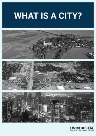
- 10. What is a city? 10 It is recommended that countries and cities adopt a unified and standardized platform for SDGs monitoring and reporting of urban indicators. UN-Habitat’s City Prosperity Initiative (CPI) offers the possibility to organize a systemic approach to the city, incorporating new analytical tools based on spatial indicators.The CPI works as a support for multi-scale decision- making that connects the city with the region and the overall country. It promotes integration of the different dimensions and components of urbanization to respond to city challenges and opportunities in a holistic and integrated manner. The CPI has been implemented in more than 400 cities across the world, integrating Goal 11 indicators and other SDGs indicators that have an urban component. Countries that use this platform are able to identify, quantify, evaluate, monitor and report on progress made by cities in a more structured manner. The adoption of an integrated approach of the city, offers the following advantages: i) Provides a single value of the state of the city; ii) Establishes benchmarks for local, national and global monitoring; iii) Creates city baseline and information; iv) Generates a local monitoring mechanism, and; v) Identifies priorities and transformative actions to achieve sustainable urban development. 6. REFERENCES [1]. United Nations, Department of Economic and Social Affairs, Population Division (2014). World Urbanization Prospects: The 2014 Revision, CD-ROM Edition. [2]. ibid [3]. UN-Habitat (2016) World Cities Report: Urbanization and Development, Emerging Futures, Nairobi. [4]. ibid [5]. United Nations, Department of Economic and Social Affairs, Population Division (2018). World Urbanization Prospects: The 2018 Revision, Methodology. Working Paper No. ESA/P/WP.252. New York: United Nations. [6]. Ibid [7]. United Nations, Department of Economic and Social Affairs, Population Division (2018). World Urbanization Prospects: The 2018 Revision, Methodology. Working Paper No. ESA/P/WP.252. New York: United Nations. [8]. UNDESA (2002). Demographic yearbook, 2000. United Nations Publications, 2002. p. 23. ISBN 92-1-051091-7. [9]. Refer to the methodology of the study “Urban Expansion of Cities” and the Global Sample of Cities, UN-Habitat, New York University and Lincoln Institute of Land Policy, 2016. [10].Metropolitan Area definition, https://www.revolvy.com/ main. [11].Statistical Commission (2016), Forty-seven session in March 2016 Cover photos 1. Small town in England, Blythburgh, Suffolk @ John Fielding / Flickr 2. Irving City, Texas @ La Citta Vita / Flickr 3. Dense city, @ Ita_Non / Flickr
- 11. What is a city? 11 Amsterdam, Netherlands @ European Space Agency / Flickr