Ground Penetrating Radar Scanning Unveiling The Secrets Beneath Our Feet
•
0 likes•2 views

Ground Penetrating Radar Scanning Unveiling The Secrets Beneath Our Feet

Recommended
Recommended
More Related Content
Similar to Ground Penetrating Radar Scanning Unveiling The Secrets Beneath Our Feet
Similar to Ground Penetrating Radar Scanning Unveiling The Secrets Beneath Our Feet (20)
More from Tec
More from Tec (20)
Recently uploaded
Recently uploaded (20)
Ground Penetrating Radar Scanning Unveiling The Secrets Beneath Our Feet
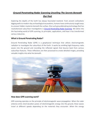
- 1. Ground Penetrating Radar Scanning Unveiling The Secrets Beneath Our Feet Exploring the depths of the Earth has always fascinated mankind. From ancient civilizations digging wells to modern-day archaeological excavations, humans have continuously sought ways to uncover hidden mysteries beneath the surface. One such groundbreaking technology that has revolutionized subsurface investigations is Ground Penetrating Radar Scanning. We delve into the fascinating world of GPR scanning, its principles, applications, and how it has transformed various industries. What is Ground Penetrating Radar? Ground Penetrating Radar (GPR) is a geophysical technique that utilizes electromagnetic radiation to investigate the subsurface of the Earth. It works by emitting high-frequency radio waves into the ground and recording the reflected signals that bounce back from various subsurface features. These reflections are then processed to create detailed images, providing valuable insights into what lies beneath. How does GPR scanning work? GPR scanning operates on the principle of electromagnetic wave propagation. When the radar antenna emits short-duration pulses of electromagnetic energy into the ground, these waves travel at different speeds depending on the materials they encounter. When the energy
- 2. encounters an object or a boundary between different materials, it reflects back to the surface, where it is captured by the radar antenna. By analyzing the travel time of the waves and the strength of the returned signals, GPR systems can generate a two-dimensional or three-dimensional representation of the subsurface. This data can reveal various features such as buried utilities, geological formations, archaeological artifacts, or even structural abnormalities in concrete structures. Components of a GPR system: A typical GPR system comprises several essential components: Control Unit: This is the central processing unit that controls the operation of the GPR system. It allows the user to set parameters, monitor data acquisition, and visualize the results. Antenna: The radar antenna is responsible for transmitting and receiving electromagnetic waves. Its design and frequency range determine the resolution and depth penetration capabilities of the GPR system. Power Supply: GPR systems are powered by rechargeable batteries or external power sources, ensuring uninterrupted operation during field surveys. Data Storage: GPR systems record the collected data, which can be stored internally or externally, depending on the system's specifications. Applications of GPR Scanning: The versatility of GPR scanning has led to its adoption in a wide range of industries. Let's explore some of the key applications where GPR has proven invaluable: • Utility Detection and Mapping One of the primary uses of GPR scanning is in locating and mapping underground utilities. Whether it's electrical cables, water pipes, or gas lines, GPR can identify their depth, position, and even detect potential damages or leaks. This information is vital for construction and maintenance projects, preventing accidental utility strikes and ensuring worker safety. • Archaeology and Cultural Heritage GPR scanning has become an indispensable tool for archaeologists and cultural heritage preservationists. By conducting non-intrusive surveys, GPR can detect buried structures, ancient burial sites, and artifacts without disturbing the delicate archaeological layers. This technology
- 3. has revolutionized the field, allowing researchers to uncover hidden secrets and gain a deeper understanding of our past. • Geology and Environmental Studies In the realm of geology and environmental studies, GPR plays a crucial role in mapping geological formations, characterizing subsurface stratigraphy, and identifying groundwater resources. It aids in assessing soil quality, detecting contaminants, and monitoring changes in groundwater levels. These insights contribute to better land management, environmental planning, and resource exploration. • Civil Engineering and Infrastructure Assessment GPR scanning is extensively used in civil engineering projects to assess the integrity of structures and infrastructure. It can identify voids, cracks, and other anomalies in concrete, asphalt, or masonry structures. GPR is also valuable for evaluating road conditions, detecting rebar corrosion, and assessing the thickness of pavements. This information allows engineers to make informed decisions regarding maintenance, repairs, or reconstructions. • Forensics and Law Enforcement GPR scanning has found applications in forensic investigations and law enforcement agencies. It can aid in locating hidden graves, detecting concealed contraband, or identifying underground tunnels. GPR's ability to visualize subsurface features helps investigators gather evidence and solve complex cases more efficiently. Advancements in GPR Technology: Over the years, GPR technology has witnessed significant advancements, enhancing its capabilities and expanding its potential applications. Some notable developments include: • Multi-frequency Antennas Modern GPR systems now feature multi-frequency antennas, enabling users to tailor the system's capabilities according to their specific needs. Higher frequencies offer better resolution but limited depth penetration, whereas lower frequencies provide greater depth but lower resolution. The ability to switch frequencies allows for versatile data collection and improved subsurface interpretation. • Real-time Data Acquisition and Processing Advancements in hardware and software have led to the development of GPR systems capable of real-time data acquisition and processing. This allows field operators to visualize the
- 4. subsurface as they scan, facilitating on-site decision-making and immediate identification of anomalies. Real-time capabilities have significantly improved survey efficiency and reduced the need for extensive post-processing. • Integration with Geographic Information Systems (GIS) GPR data is now seamlessly integrated with Geographic Information Systems (GIS) platforms, enabling geospatial visualization and analysis. By overlaying GPR results on maps and satellite imagery, users can better understand the relationship between subsurface features and the surrounding environment. This integration has opened new avenues for interdisciplinary studies and improved data interpretation. Challenges and Limitations: While GPR scanning has revolutionized subsurface investigations, it is important to acknowledge its limitations and challenges: • Depth and Resolution Limitations The depth penetration and resolution of GPR scanning are influenced by various factors, including the frequency of the antenna, soil conditions, and the presence of objects with different electrical properties. Achieving high-resolution images at significant depths remains a challenge, and trade- offs between depth and resolution are often necessary. • Data Interpretation Interpreting GPR data requires expertise and experience. Different subsurface features can produce similar signatures, making it challenging to distinguish between them accurately. Trained professionals with a comprehensive understanding of geology, electromagnetics, and the specific application domain are essential for accurate interpretation and meaningful conclusions. • Environmental Factors Environmental factors such as moisture content, soil conductivity, and electromagnetic interference can impact GPR data quality and interpretation. Conductive soils, for instance, can attenuate the radar signal, reducing depth penetration. Similarly, high levels of background noise can affect the clarity of the collected data. Adapting the survey parameters and data processing techniques to account for these factors is crucial. Conclusion:
- 5. Ground Penetrating Radar (GPR) Scanning has emerged as a powerful tool for exploring the hidden depths beneath our feet. Its ability to penetrate the subsurface and provide detailed images has transformed a wide range of industries, from construction and archaeology to environmental studies and forensics. With ongoing advancements in technology, GPR systems continue to evolve, offering improved data quality, real-time capabilities, and seamless integration with other geospatial technologies.