Understanding the Importance of GPR Utility Locating.pdf
•
0 likes•2 views

Discover the significance of Ground Penetrating Radar (GPR) utility locating in construction and excavation projects. Learn how GPR technology works and its benefits in preventing costly accidents.

Recommended
Recommended
More Related Content
Similar to Understanding the Importance of GPR Utility Locating.pdf
Similar to Understanding the Importance of GPR Utility Locating.pdf (20)
More from Tec
More from Tec (20)
Recently uploaded
Recently uploaded (20)
Understanding the Importance of GPR Utility Locating.pdf
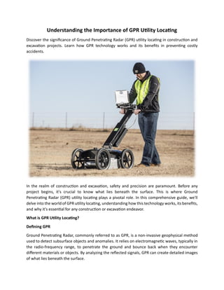
- 1. Understanding the Importance of GPR Utility Locating Discover the significance of Ground Penetrating Radar (GPR) utility locating in construction and excavation projects. Learn how GPR technology works and its benefits in preventing costly accidents. In the realm of construction and excavation, safety and precision are paramount. Before any project begins, it's crucial to know what lies beneath the surface. This is where Ground Penetrating Radar (GPR) utility locating plays a pivotal role. In this comprehensive guide, we'll delve into the world of GPR utility locating, understanding how this technology works, its benefits, and why it's essential for any construction or excavation endeavor. What is GPR Utility Locating? Defining GPR Ground Penetrating Radar, commonly referred to as GPR, is a non-invasive geophysical method used to detect subsurface objects and anomalies. It relies on electromagnetic waves, typically in the radio-frequency range, to penetrate the ground and bounce back when they encounter different materials or objects. By analyzing the reflected signals, GPR can create detailed images of what lies beneath the surface.
- 2. The Utility of Utility Locating Utility locating with GPR involves the detection of underground utilities and structures, such as pipes, cables, conduits, and even archaeological features. The goal is to accurately map the location and depth of these elements, preventing costly and potentially dangerous surprises during excavation or construction activities. How Does GPR Utility Locating Work? Understanding the inner workings of GPR technology is essential to appreciate its importance. Here's a simplified breakdown of the process: • Emission of Electromagnetic Waves GPR equipment emits electromagnetic waves into the ground. These waves can range from very low frequencies to higher frequencies, depending on the depth and resolution required for the scan. • Reflection of Waves When these waves encounter a change in material composition, such as the transition from soil to a buried utility pipe, they reflect back to the surface. The time it takes for these reflections to return is recorded by the GPR system. • Data Interpretation The GPR system then processes the data, creating a visual representation of the subsurface. This image, known as a GPR profile or scan, displays the location, depth, and size of buried objects or anomalies. Benefits of GPR Utility Locating Now that we understand the basic principles of GPR utility locating, let's explore its numerous advantages: • Enhanced Safety One of the primary benefits of GPR utility locating is enhanced safety. Construction and excavation projects often involve heavy machinery and digging equipment, making it crucial to know the precise location of underground utilities. Accidental strikes on gas lines, water pipes, or electrical cables can result in catastrophic accidents, injuries, and costly repairs. GPR minimizes these risks by providing accurate maps of underground infrastructure. • Cost Savings GPR utility locating can save construction companies substantial amounts of money. By identifying underground utilities before digging commences, project managers can plan their
- 3. excavation activities more efficiently. This reduces the likelihood of costly delays, repairs, and legal liabilities associated with damaging existing infrastructure. • Time Efficiency Time is money in the construction industry. GPR utility locating accelerates project timelines by providing real-time data about subsurface conditions. This enables construction crews to work with confidence, knowing they won't unexpectedly encounter buried obstacles. • Environmental Preservation GPR technology is environmentally friendly because it doesn't involve digging exploratory trenches or holes. This means that natural landscapes and habitats remain undisturbed, minimizing the environmental impact of construction and excavation projects. • Preservation of Historical Sites In archaeology and heritage conservation, GPR utility locating is invaluable for preserving historical sites. It allows researchers to uncover buried artifacts and structures without causing damage, making it an essential tool for archaeological excavations. Where is GPR Utility Locating Used? GPR utility locating finds applications in various industries and scenarios: • Construction In construction, GPR is used to identify underground utilities, ensuring the safety of workers and preventing damage to existing infrastructure during excavation or foundation work. • Infrastructure Maintenance Government agencies and utility companies use GPR to inspect and maintain underground infrastructure, such as water and sewer pipes, electrical cables, and communication lines. • Environmental Studies GPR technology helps environmental scientists and researchers study soil composition, detect underground water sources, and assess contamination levels without disturbing the ecosystem. • Geophysical Surveys GPR is instrumental in geophysical surveys for geological research, mapping subsurface geological features, and detecting potential hazards such as sinkholes. • Archaeology Archaeologists use GPR for non-destructive exploration of archaeological sites, uncovering ancient structures and artifacts while preserving historical integrity.
- 4. Challenges and Limitations While GPR utility locating is a powerful tool, it does have its limitations: • Depth Limitations The depth to which GPR can penetrate and provide accurate results depends on various factors, including soil conditions and the equipment used. In some cases, GPR may not be suitable for very deep utility detection. • Interpretation Complexity Interpreting GPR data requires expertise, and results can be challenging to interpret correctly. It's crucial to have trained professionals who can accurately analyze the data and identify potential hazards. Conclusion Ground Penetrating Radar (GPR) utility locating is a groundbreaking technology that has revolutionized the way we approach construction, excavation, and subsurface exploration. Its ability to provide detailed insights into underground utilities and structures enhances safety, saves costs, and preserves the environment. As we continue to rely on GPR technology, it's essential to stay informed about its capabilities and limitations. Whether you're a construction professional, an archaeologist, or an environmental scientist, GPR utility locating can be a valuable asset in your toolkit, ensuring that you dig deeper without digging into trouble.