Ground Penetrating Radar Scanning Unveiling The Secrets Below the Surface
•
0 likes•2 views

Ground Penetrating Radar Scanning Unveiling The Secrets Below the Surface

Recommended
Recommended
More Related Content
Similar to Ground Penetrating Radar Scanning Unveiling The Secrets Below the Surface
Similar to Ground Penetrating Radar Scanning Unveiling The Secrets Below the Surface (20)
More from Tec
More from Tec (20)
Recently uploaded
Recently uploaded (20)
Ground Penetrating Radar Scanning Unveiling The Secrets Below the Surface
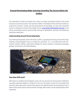
- 1. Ground Penetrating Radar Scanning Unveiling The Secrets Below the Surface The exploration of what lies beneath the surface has always fascinated mankind. From buried treasures to ancient structures, the mysteries hidden in the depths of the earth have fueled our curiosity for centuries. Luckily, with the advancement of technology, we now have a powerful tool at our disposal to uncover these hidden secrets. Ground Penetrating Radar Scanning. In this article, we will delve into the world of GPR scanning, its applications, and how it revolutionizes subsurface exploration. Understanding Ground Penetrating Radar Ground Penetrating Radar, often referred to as GPR, is a geophysical technique that utilizes high- frequency electromagnetic waves to image the subsurface. It is a non-destructive and non- invasive method, making it particularly valuable for various industries, including archaeology, geology, construction, and utility detection. How does GPR work? GPR works by emitting electromagnetic waves into the ground and measuring the reflections caused by subsurface objects or variations in the soil. The system consists of a transmitter that emits the radar signal and a receiver that captures the reflected waves. By analyzing the time, it takes for the waves to bounce back and their strength, GPR creates a visual representation of the subsurface.
- 2. The Role of Frequencies in GPR: GPR systems operate at different frequencies depending on the desired depth of penetration and the resolution required. Low-frequency signals can penetrate deeper into the ground but provide lower-resolution images, while high-frequency signals are more suitable for shallow subsurface investigations with higher resolution. The choice of frequency depends on the specific application and the nature of the target being investigated. Applications of Ground Penetrating Radar: Ground Penetrating Radar has proven to be an invaluable tool across various industries. Let's explore some of its most prominent applications. • Archaeology and Cultural Heritage One of the most captivating applications of GPR is in archaeology and cultural heritage studies. GPR allows archaeologists to examine the subsurface without disturbing delicate artifacts or historical sites. By scanning an area, archaeologists can detect buried structures, tombs, and artifacts, providing valuable insights into past civilizations. GPR has been instrumental in discovering ancient cities, hidden chambers, and even whole burial grounds. • Utility Detection Before any construction or excavation work, it is crucial to identify the location of underground utilities such as pipes, cables, and utility lines. GPR can accurately locate and map these utilities, preventing potential damage and accidents during construction activities. This application saves time, and money, and ensures the safety of workers and the integrity of existing infrastructure. • Geology and Environmental Studies GPR is widely used in geology and environmental studies for subsurface mapping and characterization. It helps in identifying geological features, such as bedrock depth, sediment layers, and groundwater resources. By analyzing GPR data, geologists can understand the structure and composition of the subsurface, aiding in geological surveys, environmental impact assessments, and groundwater management. • Road and Bridge Inspection Infrastructure maintenance and safety are of paramount importance. GPR plays a crucial role in the inspection of roads, bridges, and other transportation structures. By scanning the subsurface beneath these structures, GPR can detect voids, cracks, and other defects that may compromise
- 3. their stability. This allows for proactive maintenance and timely repairs, ensuring the safety of drivers and pedestrians. • Forensics and Law Enforcement GPR has also found applications in forensics and law enforcement investigations. It can be used to locate buried evidence or clandestine graves, assisting in criminal investigations. GPR's ability to detect buried objects and disturbances in the soil has been instrumental in uncovering crucial evidence in cold cases and missing person investigations. Advantages of Ground Penetrating Radar: Ground Penetrating Radar offers several advantages that make it a preferred choice for subsurface exploration. • Non-Destructive and Non-Invasive Unlike traditional excavation methods, GPR scanning is non-destructive and non-invasive. It allows for subsurface exploration without causing any damage to the environment, historical sites, or existing infrastructure. This advantage is particularly valuable in sensitive areas where preservation is of utmost importance. • High Resolution and Accuracy GPR provides high-resolution images of the subsurface, allowing for detailed analysis and interpretation. The accuracy of the technology has significantly improved over the years, providing precise information about the depth, location, and characteristics of subsurface objects. This level of detail is essential for making informed decisions in various industries. • Time and Cost Efficiency GPR scanning is a relatively fast process, providing real-time results. It eliminates the need for extensive excavation or drilling, saving time and reducing costs associated with traditional subsurface investigations. The efficiency of GPR makes it an attractive choice for projects with tight deadlines and budget constraints. • Limitations and Challenges: While GPR scanning is a powerful technique, it also has certain limitations and challenges that need to be considered. • Signal Attenuation and Reflections
- 4. GPR signals can be attenuated or reflected by certain materials, such as clay or metals. These reflections can complicate data interpretation and lead to false positives or false negatives. Skilled interpretation and data processing is necessary to distinguish between the genuine subsurface features and artifacts caused by reflections. • Depth Limitations The depth of penetration achievable with GPR depends on various factors, including the frequency used, soil conditions, and the presence of conductive materials. While GPR can reach depths of tens of meters under optimal conditions, it is typically more effective for shallow subsurface investigations. For deep geological studies, alternative techniques may be more suitable. • Operator Skill and Interpretation GPR scanning requires skilled operators who understand the technology and its limitations. Interpretation of GPR data can be complex, and experience is essential to differentiate between subsurface features accurately. Training and expertise play a significant role in maximizing the effectiveness of GPR scanning. The Future of Ground-Penetrating Radar: As technology continues to advance, the future of Ground Penetrating Radar looks promising. Researchers are exploring new ways to enhance the capabilities of GPR systems, improving depth penetration, resolution, and data processing techniques. Additionally, the integration of GPR with other geophysical methods, such as LiDAR and magnetic surveys, could provide a more comprehensive understanding of the subsurface. Conclusion: Ground Penetrating Radar scanning has revolutionized the way we explore the subsurface. Its non-destructive nature, high resolution, and versatility make it an invaluable tool for archaeologists, geologists, construction professionals, and law enforcement agencies. With ongoing advancements in technology and data interpretation, GPR will continue to play a crucial role in uncovering the hidden secrets buried beneath the surface, shaping our understanding of the past and aiding in future development.