
Recommended
More Related Content
What's hot
What's hot (20)
Similar to Craig10e ch04 ppt_ops_final
Similar to Craig10e ch04 ppt_ops_final (20)
More from etowens
More from etowens (20)
Recently uploaded
Recently uploaded (20)
Craig10e ch04 ppt_ops_final
- 1. Copyright © 2016, 2011, 2009 Pearson Education, Inc. All Rights Reserved The Heritage of World Civilizations Tenth Edition Chapter 4 West Asia, Inner Asia, and South Asia to 1000 C.E.
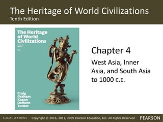
- 2. Copyright © 2016, 2011, 2009 Pearson Education, Inc. All Rights Reserved The Bodhisattva Avalokiteshvara
- 3. Copyright © 2016, 2011, 2009 Pearson Education, Inc. All Rights Reserved Learning Objectives (1 of 3) West and Inner Asia to 1000 C.E. 4.1 The Ancient Background • Trace the history of the Elamites and the Iranian peoples in ancient West Asia. 4.2 The First Persian Empire in the Iranian Plateau (550–330 B.C.E.) • Analyze the factors involved in the rise and stability of the Achaemenid Empire. 4.3 The Seleucid Successors to Alexander in the East (ca. 312–63 B.C.E.) • Summarize developments in the East under Seleucid rule.
- 4. Copyright © 2016, 2011, 2009 Pearson Education, Inc. All Rights Reserved Learning Objectives (2 of 3) 4.4 The Parthian Arsacid Empire (ca. 247 B.C.E.–223 C.E.) • Discuss the rise and decline of the Parthian Arsacid Empire and the conquests and influences of the Indo-Greeks, Scythians, and Kushans. 4.5 The Sasanid Empire (224–651 C.E.) • Discuss the rise of the Sasanid Empire and its social, economic, and religious institutions. South Asia to 1000 C.E. 4.6 The First Indian Empire: The Mauryas (321–185 B.C.E.) • Discuss the Maurya empire and its greatest leader, Ashoka.
- 5. Copyright © 2016, 2011, 2009 Pearson Education, Inc. All Rights Reserved Learning Objectives (3 of 3) 4.7 The Consolidation of Indian Civilization (ca. 200 B.C.E.–300 C.E.) • Describe Indian civilization in the post-Maurya period. 4.8 The Golden Age of the Guptas (ca. 320–550 C.E.) • Describe Indian civilization in the Gupta era. 4.9 The Development of “Classical” Indian Civilization (ca. 300–1000 C.E.) • Discuss social and religious life in “classical” Indian civilization.
- 6. Copyright © 2016, 2011, 2009 Pearson Education, Inc. All Rights Reserved Introduction (1 of 2) • From 600 B.C.E. to the rise of Islam in 700 C.E., strong centralized empires emerged in Asia. • Cultural and political contacts increased in Western Asia. • The empire of the Achaemenids (ca. 539–330 B.C.E.) and the Seleucid Empire (312–125 B.C.E.) dominated Western and Inner Asia.
- 7. Copyright © 2016, 2011, 2009 Pearson Education, Inc. All Rights Reserved Introduction (2 of 2) • Dynasty of the Sasanids in Iran (224–651 C.E.) and Mauryas in India (321 B.C.E.–185 B.C.E.) built sophisticated bureaucracies, professional armies, and strong communication systems. • This period was marked by sustained contact from the Mediterranean to China, dramatically increased contact among diverse cultures, races, and religious traditions, and the rise of major religious traditions.
- 8. Copyright © 2016, 2011, 2009 Pearson Education, Inc. All Rights Reserved Global Perspective: Indo-Iranian Roles in the Eurasian World before Islam (1 of 2) • The Achaemenids and Sasanids in Iran and the Mauryas and Guptas in India were counterparts of the Roman-Byzantine world and Han China. • The empires displayed cultural vibrancy, economic prosperity, and wide dominion. • These empires played an important role in spreading religions, especially Buddhist traditions across Asia. • The post-Alexander states of West and Inner Asia and Northwest India were important cultural melting pots between the East and West.
- 9. Copyright © 2016, 2011, 2009 Pearson Education, Inc. All Rights Reserved Global Perspective: Indo-Iranian Roles in the Eurasian World before Islam (2 of 2) 1. Why is a Eurocentric perspective not helpful for understanding the world in the first millennium C.E.? How does a global perspective offer a better understanding of the development of civilizations in this era? 2. Why did this period see a significant increase in cross-cultural contacts? How were these contacts manifested? Who participated in these increased contacts?
- 10. Copyright © 2016, 2011, 2009 Pearson Education, Inc. All Rights Reserved West and Inner Asia to 1000 C.E. Map 4–1: West and Inner Asia
- 11. Copyright © 2016, 2011, 2009 Pearson Education, Inc. All Rights Reserved West and Inner Asia to 1000 C.E. Map 4–2: Eurasian Trade Routes ca. 100 C.E.
- 12. Copyright © 2016, 2011, 2009 Pearson Education, Inc. All Rights Reserved West and Inner Asia to 1000 C.E. 4.1 The Ancient Background Learning Objective: Trace the history of the Elamites and the Iranian peoples in ancient West Asia.
- 13. Copyright © 2016, 2011, 2009 Pearson Education, Inc. All Rights Reserved 4.1.1 The Elamites • The Elamites created an empire in western Asia, and that empire was eventually destroyed by the Assyrians.
- 14. Copyright © 2016, 2011, 2009 Pearson Education, Inc. All Rights Reserved 4.1.2 The Iranian Peoples • Aryan pastoralists settled on the Iranian plateau around 1100 B.C.E. • The most prominent of these settlers were the Medes and Persians. • The rise of the Persian Achaemenids from the seventh century B.C.E. led to the end of Median supremacy. • Many of the institutions developed in the ensuing Achaemenid Empire derive from Median practices.
- 15. Copyright © 2016, 2011, 2009 Pearson Education, Inc. All Rights Reserved 4.1.3 Ancient Iranian Religion • Ancient Iranian religion focused on a moral order. • The religions worshipped the supreme heavenly deity Ahura Mazda, the “Wise Lord.” • These religious traditions in the early second millennium had substantial regional variations.
- 16. Copyright © 2016, 2011, 2009 Pearson Education, Inc. All Rights Reserved 4.1.4 Zoroaster and the Zoroastrian Tradition • Zoroaster preached moral reform in an age of materialism, political opportunism, and ethical indifference. • By the mid–fourth century B.C.E., the Zoroastrian reform had spread into western and eastern Iran. • The Iranian priestly clan of the Magi may have integrated Zoroastrian ideas into their traditions. • Zoroastrianism probably influenced Jewish, Christian, Muslim, and Buddhist religious concepts.
- 17. Copyright © 2016, 2011, 2009 Pearson Education, Inc. All Rights Reserved Document: A Hymn of Zoroaster about the Spirits of Good and Evil • What lesson or values does this passage teach? • Is there a conflict between the seeming omnipotence ascribed to Ahura Mazda and the existence of the Evil Spirit? • How does the sharp choice offered here compare to the Buddha’s Middle Path (see “The ‘Turning of the Wheel of the Dharma’” in Chapter 2)?
- 18. Copyright © 2016, 2011, 2009 Pearson Education, Inc. All Rights Reserved Zoroastrian Priests
- 19. Copyright © 2016, 2011, 2009 Pearson Education, Inc. All Rights Reserved West and Inner Asia to 1000 C.E. 4.2 The First Persian Empire in the Iranian Plateau (550–330 B.C.E.) Learning Objective: Analyze the factors involved in the rise and stability of the Achaemenid Empire.
- 20. Copyright © 2016, 2011, 2009 Pearson Education, Inc. All Rights Reserved 4.2.1 The Achaemenids • Achaemenid rule in southwestern Iran (Persia) dates back at least to Cyrus I (d. 600 B.C.E.). • The rise of Iran as a major imperial civilization is usually dated from the reign of Cyrus the Great (559–530 B.C.E.). • Cyrus ruled through local elites and institutions rather than imperial administrative structures. • Alexander the Great destroyed the Achaemenids by 330 B.C.E.
- 21. Copyright © 2016, 2011, 2009 Pearson Education, Inc. All Rights Reserved Daric
- 22. Copyright © 2016, 2011, 2009 Pearson Education, Inc. All Rights Reserved 4.2.2 The Achaemenid State • Achaemenid rule was characterized by great stability. • Rulers adopted the title Shahanshah, “king of kings,” to justify their sovereignty under Ahura Mazda. • The Achaemenids were tolerant of other cultural and religious traditions. • Cyrus’s state was replaced by a monarchy supported by a noble class, professional armies, and an administrative system of provinces ruled by governors called satraps.
- 23. Copyright © 2016, 2011, 2009 Pearson Education, Inc. All Rights Reserved 4.2.3 The Achaemenid Economy • The Achaemenids created a coin-based monetary system. • Economic diversity, expanding trade, and general prosperity underpinned the stability of Achaemenid rule.
- 24. Copyright © 2016, 2011, 2009 Pearson Education, Inc. All Rights Reserved West and Inner Asia to 1000 C.E. 4.3 The Seleucid Successors to Alexander in the East (ca. 312–63 B.C.E.) (1 of 2) Learning Objective: Summarize developments in the East under Seleucid rule.
- 25. Copyright © 2016, 2011, 2009 Pearson Education, Inc. All Rights Reserved 4.3 The Seleucid Successors to Alexander in the East (ca. 312–63 B.C.E.) (2 of 2) • Alexander’s policies of Hellenic-Persian fusion helped make Seleucid rule viable in many eastern areas. • During the second century B.C.E., Hellenistic culture and law became new ideals among Seleucid elites. • Greek culture penetrated but did not displace local social and cultural forms.
- 26. Copyright © 2016, 2011, 2009 Pearson Education, Inc. All Rights Reserved West and Inner Asia to 1000 C.E. 4.4 The Parthian Arsacid Empire (ca. 247 B.C.E.–223 C.E.) (1 of 2) Learning Objective: Discuss the rise and decline of the Parthian Arsacid Empire and the conquests and influences of the Indo- Greeks, Scythians, and Kushans.
- 27. Copyright © 2016, 2011, 2009 Pearson Education, Inc. All Rights Reserved West and Inner Asia to 1000 C.E. 4.4 The Parthian Arsacid Empire (ca. 247 B.C.E.–223 C.E.) (2 of 2) • The steppe peoples from the Central Asian steppes dominated the Iranian plateau from about 250 B.C.E. to 300 C.E. • The Parni, later known as the Parthians, established an empire east of the Euphrates by 129 B.C.E. • The Parthians were oriented toward the Hellenistic world until an Iranian revival in the mid–first century C.E.
- 28. Copyright © 2016, 2011, 2009 Pearson Education, Inc. All Rights Reserved Parthian Warrior
- 29. Copyright © 2016, 2011, 2009 Pearson Education, Inc. All Rights Reserved 4.4.1 Indo-Greeks • The farthest reach of Hellenization in the East came with the Indo-Greek rulers of Bactria. • The Indo-Greeks probably helped spread Buddhism from India to Central Asia.
- 30. Copyright © 2016, 2011, 2009 Pearson Education, Inc. All Rights Reserved Greco-Buddhist Art
- 31. Copyright © 2016, 2011, 2009 Pearson Education, Inc. All Rights Reserved 4.4.2 Scythians • Beginning around 130 B.C.E., Scythian tribes overran northeastern Iran, ending the Indo- Greek dominance.
- 32. Copyright © 2016, 2011, 2009 Pearson Education, Inc. All Rights Reserved 4.4.3 Kushans • The Kushan kingdom of was one of four major centers of civilization in Eurasia around 100 C.E.
- 33. Copyright © 2016, 2011, 2009 Pearson Education, Inc. All Rights Reserved Chronology: Iran to the Third Century C.E.
- 34. Copyright © 2016, 2011, 2009 Pearson Education, Inc. All Rights Reserved West and Inner Asia to 1000 C.E. 4.5 The Sasanid Empire (224–651 C.E.) (1 of 2) Learning Objective: Discuss the rise of the Sasanid Empire and its social, economic, and religious institutions.
- 35. Copyright © 2016, 2011, 2009 Pearson Education, Inc. All Rights Reserved West and Inner Asia to 1000 C.E. 4.5 The Sasanid Empire (224–651 C.E.) (2 of 2) • Sasanids were a Persian dynasty who claimed to be the rightful Achaemenid heirs. • The center of the Roman Empire shifted east to Byzantium in the early fourth century C.E. • This shift led to 350 years of conflict between the Byzantines and the Sasanids.
- 36. Copyright © 2016, 2011, 2009 Pearson Education, Inc. All Rights Reserved Sasanid Victory
- 37. Copyright © 2016, 2011, 2009 Pearson Education, Inc. All Rights Reserved 4.5.1 Society and Economy • The basis of the Sasanid economy was agriculture. • The Sasanids also heavily taxed the lucrative caravan and sea trade in their territory. • The empire’s many urban centers and its foreign trade relied on a money system. • The Sasanids invented the concept of the check as a financial instrument.
- 38. Copyright © 2016, 2011, 2009 Pearson Education, Inc. All Rights Reserved West and Inner Asia to 1000 C.E. Map 4–3: International Trade Routes in Gupta and Sasanid Times
- 39. Copyright © 2016, 2011, 2009 Pearson Education, Inc. All Rights Reserved 4.5.2 Religion • The Sasanids institutionalized Zoroastrian ritual and theology as state orthodoxy. • The Manichaean worldview centered on a radically dualistic and moralistic view of reality. • Manichaeism spread westward to challenge the Christian church and eastward along the Silk Road to vie with Buddhism. • Nestorian Christianity was protected by the Sasanids and spread eastward into China.
- 40. Copyright © 2016, 2011, 2009 Pearson Education, Inc. All Rights Reserved Document: Tansar’s Defense of His King, Ardashir I • Why might Tansar be an apologist for Ardashir I? • What can be inferred about the relationship between religious and imperial authority under the Sasanids?
- 41. Copyright © 2016, 2011, 2009 Pearson Education, Inc. All Rights Reserved Manichaean Priests
- 42. Copyright © 2016, 2011, 2009 Pearson Education, Inc. All Rights Reserved Nestorian Christianity in China
- 43. Copyright © 2016, 2011, 2009 Pearson Education, Inc. All Rights Reserved 4.5.3 Later Sasanid Developments • The Mazdakite movement at the end of the fifth century aimed to end inequality. • Mazdak and his most important followers were massacred in 528.
- 44. Copyright © 2016, 2011, 2009 Pearson Education, Inc. All Rights Reserved Chronology: Sasanid Iran
- 45. Copyright © 2016, 2011, 2009 Pearson Education, Inc. All Rights Reserved South Asia to 1000 C.E. 4.6 The First Indian Empire: The Mauryas (321–185 B.C.E.) Learning Objective: Discuss the Maurya empire and its greatest leader, Ashoka.
- 46. Copyright © 2016, 2011, 2009 Pearson Education, Inc. All Rights Reserved 4.6.1 Political Background • The basis for an empire in North India was the rise of regional states and commercial towns between the seventh and fourth centuries B.C.E. • Magadha dynasty dominated until it was replaced by the Nandas dynasty. • The Nandas were in turn replaced by the Maurya clan.
- 47. Copyright © 2016, 2011, 2009 Pearson Education, Inc. All Rights Reserved 4.6.2 The Mauryas (1 of 2) • The Maurya Empire was the first true Indian empire. • Chandragupta Maurya (r. ca. 321–297 B.C.E.) founded the empire. • He built his empire with the advice of his Brahman minister, Kautilya. • Chandragupta’s son, Bindusara (r. ca. 297–272 B.C.E.), conquered the Deccan.
- 48. Copyright © 2016, 2011, 2009 Pearson Education, Inc. All Rights Reserved 4.6.2 The Mauryas (2 of 2) • The greatest Maurya leader, Ashoka (ca. 272– 232 B.C.E.), extended control over the whole Indian subcontinent except the far south. • Ashoka converted to Buddhism and spread Buddhist teaching. • He eventually moved toward “conquest by righteousness (dharma).” • After Ashoka’s death, local dynasties seized power in many areas.
- 49. Copyright © 2016, 2011, 2009 Pearson Education, Inc. All Rights Reserved South Asia to 1000 C.E. Map 4–4: Southwest Asia and India ca. 250 B.C.E.
- 50. Copyright © 2016, 2011, 2009 Pearson Education, Inc. All Rights Reserved Document: The Edicts of Ashoka • What does Ashoka suggest is the role of the monarch? • What is his concept of “conquest”? • What does he think of those of other faiths and want for them? • What reforms does Ashoka propose, and why? • Can you reconcile his expressed abhorrence of killing with his words to the forest tribes? • How do these edicts compare to other approaches to law, leadership, and government?
- 51. Copyright © 2016, 2011, 2009 Pearson Education, Inc. All Rights Reserved Chronology: India from the Sixth Century B.C.E. to the End of Maurya Rule
- 52. Copyright © 2016, 2011, 2009 Pearson Education, Inc. All Rights Reserved South Asia to 1000 C.E. 4.7 The Consolidation of Indian Civilization (ca. 200 B.C.E.–300 C.E.) (1 of 2) Learning Objective: Describe Indian civilization in the post- Maurya period.
- 53. Copyright © 2016, 2011, 2009 Pearson Education, Inc. All Rights Reserved South Asia to 1000 C.E. 4.7 The Consolidation of Indian Civilization (ca. 200 B.C.E.–300 C.E.) (2 of 2) • The centuries between the Mauryas and the Guptas helped permanently shape India.
- 54. Copyright © 2016, 2011, 2009 Pearson Education, Inc. All Rights Reserved A Closer Look: Lion Capital of Ashoka at Sarnath
- 55. Copyright © 2016, 2011, 2009 Pearson Education, Inc. All Rights Reserved 4.7.1 The Economic Base • India became a center of world trade largely because of Chinese and Roman demand for Indian luxury goods.
- 56. Copyright © 2016, 2011, 2009 Pearson Education, Inc. All Rights Reserved 4.7.2 High Culture • In the arts, the great achievements of the post-Maurya era were primarily inspired by Buddhism.
- 57. Copyright © 2016, 2011, 2009 Pearson Education, Inc. All Rights Reserved 4.7.3 Religion and Society • Buddhist monasticism and popular Hindu devotional cults thrived across the subcontinent, including Buddhist stupas. • The two masterpieces of Sanskrit culture and Hinduism, the Mahabharata and the Ramayana, probably took shape by 200 C.E. • A cult of the person of Buddha developed. • Buddhist lay devotion figured prominently in Indian religious life.
- 58. Copyright © 2016, 2011, 2009 Pearson Education, Inc. All Rights Reserved The Great Stupa at Sanchi
- 59. Copyright © 2016, 2011, 2009 Pearson Education, Inc. All Rights Reserved South Asia to 1000 C.E. 4.8 The Golden Age of the Guptas (ca. 320–550 C.E.) (1 of 2) Learning Objective: Describe Indian civilization in the Gupta era.
- 60. Copyright © 2016, 2011, 2009 Pearson Education, Inc. All Rights Reserved South Asia to 1000 C.E. 4.8 The Golden Age of the Guptas (ca. 320–550 C.E.) (2 of 2) • The Gupta era was a golden age of civilization in the subcontinent.
- 61. Copyright © 2016, 2011, 2009 Pearson Education, Inc. All Rights Reserved 4.8.1 Gupta Rule • The first Gupta king was Chandragupta, who extended his territory through marriage. • Unlike the Mauryas, the Guptas usually accepted a defeated ruler as a vassal prince.
- 62. Copyright © 2016, 2011, 2009 Pearson Education, Inc. All Rights Reserved Gupta Sculpture
- 63. Copyright © 2016, 2011, 2009 Pearson Education, Inc. All Rights Reserved Document: A Chinese Traveler’s Report on the Gupta Realm • What things about India seem to surprise Faxian most? • Is his image of Indian rule positive? • How do his remarks speak to the prestige of the Buddhist tradition and its monks in the Indian state? • What does he tell us about Indian society?
- 64. Copyright © 2016, 2011, 2009 Pearson Education, Inc. All Rights Reserved 4.8.2 Gupta Culture • Outside influence within Indian culture was limited after the Gupta era. • Much of Southeast Asia was heavily influenced by Indian culture and religion. • The Gupta era witnessed great advances in the sciences and mathematics.
- 65. Copyright © 2016, 2011, 2009 Pearson Education, Inc. All Rights Reserved South Asia to 1000 C.E. Map 4–5: Indian Influence in Southeast Asia, ca. 650
- 66. Copyright © 2016, 2011, 2009 Pearson Education, Inc. All Rights Reserved South Asia to 1000 C.E. 4.9 The Development of “Classical” Indian Civilization (ca. 300–1000 C.E.) (1 of 2) Learning Objective: Discuss social and religious life in “classical” Indian civilization.
- 67. Copyright © 2016, 2011, 2009 Pearson Education, Inc. All Rights Reserved South Asia to 1000 C.E. 4.9 The Development of “Classical” Indian Civilization (ca. 300–1000 C.E.) (2 of 2) • In Gupta times and after, Indian civilization assumed its classical shape, its enduring “Hindu” forms of social, religious, and cultural life.
- 68. Copyright © 2016, 2011, 2009 Pearson Education, Inc. All Rights Reserved 4.9.1 Society • The fundamentally hierarchical character of Hindu and Indian society solidified. • The roles of karma and dharma became fundamental within the lives of the people. • Within the caste system there are further distinctions, jatis.
- 69. Copyright © 2016, 2011, 2009 Pearson Education, Inc. All Rights Reserved 4.9.2 Religion (1 of 2) • The Gupta period and after saw the growth of devotional cults of deities. • The temple worship of a particular deity became a basic form of Hindu piety. • The tradition of ardent theism known as bhakti, or “loving devotion,” developed within Hinduism.
- 70. Copyright © 2016, 2011, 2009 Pearson Education, Inc. All Rights Reserved 4.9.2 Religion (2 of 2) • The two main strands of Buddhist tradition, the Mahayana and the Theravada, formed. • The Mahayana tradition taught that the highest goal was to attain the status of a bodhisattva, or “Buddha-to-be.”
- 71. Copyright © 2016, 2011, 2009 Pearson Education, Inc. All Rights Reserved Document: Devoting Oneself to Krishna • How is the understanding of older Indian religious practices and ideals (sacrifice, for example) transformed here? • How does the Lord Krishna present himself in relation to other deities? • Does the passage present a sharp dichotomy between faith and works? • What are the social implications of the message here?
- 72. Copyright © 2016, 2011, 2009 Pearson Education, Inc. All Rights Reserved Document: The Bodhisattva Ideal • The ideal of compassion for all beings is central in the Mahayana. How is this developed in the first passage? • How is it used in the second to polemicize against Theravada ideals? • What might be the appeal of the bodhisattva ideal as opposed to the older Arahant ideal?
- 73. Copyright © 2016, 2011, 2009 Pearson Education, Inc. All Rights Reserved The Buddhist Temple of Borobodur
- 74. Copyright © 2016, 2011, 2009 Pearson Education, Inc. All Rights Reserved Chronology: India from the Gupta Age to ca. 1000
- 75. Copyright © 2016, 2011, 2009 Pearson Education, Inc. All Rights Reserved South Asia to 1000 C.E. Map 4–6: Spread of Buddhist Traditions throughout Southeast Asia
- 76. Copyright © 2016, 2011, 2009 Pearson Education, Inc. All Rights Reserved Dancing Shiva
Editor's Notes
- Detail of a Buddhist wall painting from the cave shrines at Ajanta (Maharashtra, India), Gupta period, ca. 475 C.E. Avalokiteshvara (known in China as Kwanyin and in Japan as Kannon) is the bodhisattva of infinite mercy.
- The Achaemenid Persian Empire, created by Cyrus, had reached its fullest extent under Darius when Persia attacked Greece in 490 B.C.E. As shown by the colored area on the map, it extended from the subcontinent of India to the Aegean Sea, and even into Europe, encompassing the lands formerly ruled by Egyptians, Hittites, Babylonians, and Assyrians. The main segment of the Achaemenid “Royal Highway” (shown in red from Sardis to Susa) took some 90 days to traverse on foot.
- An extensive network of overland and sea routes connected Eurasia from the Mediterranean Sea to the China mainland. The central position of the Iranian plateau, Inner Asia, and the subcontinent of India in this vast trading zone provided them with great wealth and influence, although North and East Africa and Southeast Asia formed important links as well.
- Zoroastrian priests hold hands around a devotional flame during a religious New Year’s celebration in London in 1999.
- A gold coin first minted under Darius I of Persia, fourth century b.c.e.
- The Parthians were superb fighters and were particularly noted for the “Parthian shot,” firing arrows backward while mounted on a galloping horse. It is not difficult to imagine the fear that must have gripped non–horse-riding peoples upon the sight of such swift and mobile cavalry forces.
- A sculpted head of the Buddha, second century b.c.e. Hellenistic influences are evident in the realistic modeling and sculptural plasticity.
- Cliff-cut tombs at Nagsh-i Rustam, Iran. Stone relief depicts Philip the Arab in Roman dress kneeling before the third-century Persian King Shapur I on horseback wearing royal armor and crown, who grasps with his right hand the uplifted arms of the Byzantine Emperor Valerian. Located at the tombs of the Achaemenids, in Istakhr, Iran.
- This map shows the Gupta and Sasanid empires and the trade routes that linked them to each other and to other areas of the world.
- This leaf from a Manichaean book (ca. eighth–ninth century c.e.) shows priests in white robes and tall hats kneeling in front of low desks. Each has a sheet of white paper, and some hold pens. Works such as this are an important source for our knowledge of Manichaean communities.
- The spread of Christianity along the Silk Road perfectly illustrates the close connection between missionary activity and trading routes in late antiquity. Although the Nestorians had little impact on Christian communities in the Mediterranean and Europe, they were well represented from Iran east along the Silk Road to China. The stele depicted here, built in 781 c.e., commemorates the introduction of Nestorian Christianity to China.
- This map shows not only the major cities and regions of the Iranian lands and the Indian subcontinent, but also the neighboring eastern Mediterranean world. Although the Mediterranean was closely tied to the Iranian plateau from Achaemenid times onward, its contacts with India in the wake of the conquests of Alexander the Great were many and varied.
- This sculpture, carved from a single sandstone block, sat originally (c. 250 b.c.e.) atop the Ashoka pillar or column at Sarnath, close by Varanasi (Banares) in present-day Uttar Pradesh, India. The base of the column is still in its original place (where it commemorated the Buddha’s first sermon), but the lion capital resides in Sarnath Museum. The heads of the four Asiatic lions on the Ashoka column are said to have originally carried a large dharmachakra (now lost) above them. Used by Ashoka as the emblem of his rule, it was also adopted in 1950 as the Indian National Emblem or Seal and set, minus the lotus, over Sanskrit words from the Mundaka Upanishad, “Truth alone triumphs.” 1. Why might Ashoka have chosen the elements used in this capital as emblematic of his rule? Draw on what you know of his reign and life. 2. Why might independent India have decided on this royal emblem of an ancient Buddhist ruler as its national emblem? How does its symbolism transcend its possible original Buddhist symbolism? 3. How can the chakra be an apposite symbol both in Ashokan usage and in modern Indian usage?
- This is an outstanding example of early Buddhist relic mounds. The mound, seated on an Ashokan foundation, was added to over the centuries. Magnificent carvings adorn its stone railing and gateways, one of which is shown in the left foreground. Sanchi is located in north-central India.
- Fifth-century statue of Lokanatha from Sarnath, which, despite damage, shows the fine sculptural work of the important school of Gupta artists at Sarnath and the influence on them of both Greco-Roman antecedents and native Indian traditions and conventions.
- By the middle of the seventh century c.e., Indian traditions, art, and music exerted a pervasive influence throughout Southeast Asia, even though the number of Indians who traded and migrated there was not great.
- The Buddhist Temple of Borobodur with tiers of stupas looking out over the island of Java. Built out of a half million blocks of stone, it represents a schema of the Buddhist cosmos. Construction began late in the eighth century c.e.; the temple was intended originally to be a Hindu sanctuary.
- By the twelfth century c.e., Buddhist traditions had taken root in many parts of Southeast Asia, often blending with local customs, as well as with Hindu traditions that had been introduced earlier.
- A magnificent South Indian bronze of Shiva. The fluid, balanced image depicts the so-called dancing Shiva engaged in his dance of simultaneous destruction and creation of the universe, an artistic-mythical rendering of the eternal flux of all worldly existence.