SlideShare a Scribd company logo
1 of 6
Download to read offline
IJRET: International Journal of Research in Engineering and Technology eISSN: 2319-1163 | pISSN: 2321-7308
_______________________________________________________________________________________
Volume: 05 Issue: 03 | Mar-2016, Available @ http://www.ijret.org 419
DESIGN AND IMPLEMENTATION OF THREE-DIMENSIONAL
OBJECTS IN DATABASE MANAGEMENT SYSTEMS
Kazi Shamsul Arefin1*
, Mohammed Salim Bhuyan2
, Ashique Al Rahman3
1,2,3
American World University, CA, USA (Bangladesh Study Centre)
1*
Research Scholar, ksarefin@yahoo.com, www.ksarefin.info
Abstract
The idea of this research is to incorporate three-dimensional information into relational database management system and hence
implementation in geographical information system and computer aided design. This is because; database management system
has inadequate resource to preserve three-dimensional information. On the other hand, there are a lot of potential applications
that would be greatly benefited utilizing three-dimensional data. As there is no currently available three-dimensional data type
therefore this research leads to identify the three-dimensional objects and develop the data type accordingly.
Keywords: Database Management System (DBMS); Three-Dimensional (3D); Geographical Information System
(GIS); Geo-DBMS; Computer Aided Design (CAD).
--------------------------------------------------------------------***----------------------------------------------------------------------
1. INTRODUCTION
The earth is not flat; it is three-dimensional (3D). Where, we
continuously work together with three objects that are width,
height and depth. The design of 3D database system has to
be satisfied with a number of designs criteria like: data type
definition, properties of data types and entities. Finally, this
research leads to the development of 3D objects in Geo-
Database Management Systems (DBMS).
1.1Statement of the Problem
In case of 2D data, we have two dimensions, such as length
and width; however, 3D data have an additional dimension,
such as height. In DBMS, height information was always
overlooked. With this, the height is approximated and
included in calculations for these operations. There are some
weaknesses for 3D data model in DBMS:
 DBMS does not differentiate 3D objects
 Inconsistency in continuous flat topology characteristic
in GIS systems
 Problematic in the execution of spatial analyses in the
GIS systems
 Problematic to provide solution for spatial overlap
1.2 Objectives of this Research
Some researchers are working on 3D geometry data types.
However, there are still not recognized 3D data types by the
spatial extent in DBMS. The objectives of this research are
as follows:
1. To offer 3D data type in DBMS;
2. To develop a data structure that can handle with large
data and offers support for analyzing, validation and
querying;
3. Propose the next generation topology in DBMS for CAD
and geo-DBMS.
2. BENEFITS OF 3D-DBMS DEVELOPMENT
There are a lot of advantages utilizing 3D data type in order
to preserve 3D information. Now-a-days, some DBMS are
trying to preserve 3D information introducing spatial
concepts. As mentioned before, depth (Z-coordinate) is
ignored or missing in DBMS. Introducing 3D information is
a good approach although it is still insufficient. This
concept is developed on the basis of geometry models.
There are many advantages using 3D DBMS model:
 Avoids redundant storage
 Consistency in data editing
 Easier to maintenance
 Efficient in visualization
 Efficient in query operations
 Natural data model for applications
3. GENERAL DATA TYPE
Each column of DBMS has a name with appropriate data
type. Developer decides what type of data will be stored
inside the column based on the attribute. In this section, a
table: T_CITY_INFO is created with 4 (Four) columns:
Rank, City, Population, Latitude Longitude and Altitude for
this research that leads to the 3D data type in section: 5.0.
Illustration 3.1: Table T_CITY_INFO without a spatial
geometry column.
CREATE TABLE T_CITY_INFO
(
Rank NUMBER(4),
City VARCHAR2(20 byte),
Population NUMBER(10),
Latitude NUMBER(10,7),
Longitude NUMBER(10,7),
IJRET: International Journal of Research in Engineering and Technology eISSN: 2319-1163 | pISSN: 2321-7308
_______________________________________________________________________________________
Volume: 05 Issue: 03 | Mar-2016, Available @ http://www.ijret.org 420
Altitude NUMBER(10,7)
);
We gathered GIS information for 140 cities in Bangladesh
and inserted data (City name, population, Longitude and
Latitude) into T_CITY_INFO. After the execution of
‘INSERT’ statements, ‘COMMIT’ command is placed in
order to save into database permanently then data
availability is cross-checked using ‘SELECT’ statement.
SELECT RANK,CITY,POPULATION,LATITUDE,LONGITUDE
from T_CITY_INFO;
3.1 Limitations
Now if we would like to preserve information on
geographical areas (see Figure 3.1 and 3.2) in the table:
T_CITY_INFO then it is not possible in the traditional way.
Besides, there is no such data type in oracle database that is
able to hold this information. In this case what a traditional
DBMS does:
 Additional table will be created to preserve information
 Use referential keys (Foreign key) in order to make join
in different tables
Hence, there are some limitations mentioned bellows:
 Consuming more memory (Redundant information)
 Need to join in both table (Primary and Foreign key)
 Perform slower as both not in the same table
 Need to indexing in order to fetching data
 Complexity in maintaining 2 (two) different physical
tables
 Complexity in finding related information
Fig-3.1: Geographical information of Comilla,
Bangladesh
1
1https://www.google.com.bd/maps/place/Comilla
Fig-3.2: Geographical information of Mymensingh,
Bangladesh2
In the section 4.0: Spatial data type is designed to overcome
this issue.
4. SPATIAL DATA TYPE DESIGN
Oracle Spatial is incorporated with a set of procedures,
functions that supports for 3D data. Spatial data represents
the essential location characteristics of real or conceptual
objects as those objects relate to the real or conceptual
space. Spatial can be stated to:
 Dimension
 Space
 Three-dimensional space
In this section, a new column is added in the table:
T_CITY_INFO that can hold geographical information then
it is tested well with sufficient input operations. The name of
that new column is GEO_INFO. It can hold GIS information
in the table T_CITY_INFO.
ALTER TABLE T_CITY_INFO ADD (GEO_INFO
SDO_GEOMETRY);
table T_CITY_INFO altered.
 Here updating the co-ordinate information as per figure
3.1 for the city of ‘Comilla’. There is an object
SDO_ORDINATE_ARRAY in SDO_GEOMETRY
where longitude and latitude are being updated. This is
how GEO_INFO is holding data.
UPDATE T_CITY_INFO
SET GEO_INFO =
SDO_GEOMETRY(
2https://www.google.com.bd/maps/place/mymensingh
IJRET: International Journal of Research in Engineering and Technology eISSN: 2319-1163 | pISSN: 2321-7308
_______________________________________________________________________________________
Volume: 05 Issue: 03 | Mar-2016, Available @ http://www.ijret.org 421
NULL,
NULL,
NULL,
SDO_ELEM_INFO_ARRAY(LONGITUDE, LATITUDE,
NULL),
SDO_ORDINATE_ARRAY(23.481967, 91.148458,
…………………………………………………………………
23.461970, 91.140046)
)
WHERE RANK=64;
1 rows updated.
 Now fetching information for the city of ‘Comilla’.
Where, GEO_INFO is containing information.
SELECT * FROM T_CITY_INFO WHERE RANK=64;
RANK CITY POPULATION LATITUDE
LONGITUDE GEO_INF0
--------------------------------------------------
64 Comilla 305700 23.46
91.17
MDSYS.SDO_GEOMETRY(NULL,NULL,NULL,MDSYS.S
DO_ELEM_INFO_ARRAY(91.17,23.46,null),MDSYS.SDO_ORD
INATE_ARRAY(23.481967,91.148458,23.493361,91.16553
8,23.49102,91.194034,23.461655,91.222014,23.442285
,91.223302,23.493361,91.165538,23.426771,91.217122
,23.422676,91.202445,23.423227,91.182361,23.445828
,91.145024,23.46197,91.140046))
 The same procedure is followed to update information of
‘Mymensingh’ city and fetching information of that city.
The rank of ‘Mymensingh’ is 85.
SELECT * FROM T_CITY_INFO WHERE RANK=85;
RANK CITY POPULATION LATITUDE
LONGITUDE GEO_INF0
--------------------------------------------------
85 Mymensingh 244000 24.75
90.4
MDSYS.SDO_GEOMETRY(NULL,NULL,NULL,MDSYS.S
DO_ELEM_INFO_ARRAY(90.4,24.75,null),MDSYS.SDO_ORDI
NATE_ARRAY(24.782191,90.342722,24.780866,90.362205
,24.777593,90.370617,24.777533,90.381432,24.770813
,90.395937,24.75694,90.41482,24.739636,90.42778,24
.728644,90.437393,24.719054,90.448465,24.71422,90.
427523,24.715156,90.406752,24.782191,90.342722,24.
728488,90.395851,24.749224,90.370359,24.765358,90.
359116))
4.1 Limitations
In the figure 3.1 and 3.2 have only two dimensions. There
are 2 (two) axis: horizontal and vertical (X and Y)
dimensions in two-dimension (2D). However, 3D has one
more dimension that is depth (Z). Now if we would like to
keep altitude (Z) dimension on geographical area (figure
4.1) in the same table: T_CITY_INFO then it is not possible
in this way. As there is no such type of data type in oracle
database that can put this information. We can use the oracle
spatial objects in order to do that. However, still there are
some dependencies and limitations. Such as:
 Some DBMSs even do not support the spatial concepts
 Inappropriate in data dimensionality and structure
In the section 5.0, a custom made 3D data type is designed
based on requirements in order to make life easier.
Fig-4.1: 3D (Longitude, Latitude and Altitude)
Geographical information of Comilla, Bangladesh
5. THREE-DIMENSIONAL DATA TYPE
DESIGN
In the figure 4.1, we are getting 3D (Longitude, Latitude and
Altitude) geographical information for a city. Therefore, a
new data type “GEO_3D_OBJ” is developed in order to
keep 3D information in this section.
 First: an object is created with 3 (three) attributes:
Longitude, Latitude and Altitude (properties of these
columns are numeric). The name of this object is
GEO_3D_ARRAY.
CREATE TYPE GEO_3D_ARRAY AS OBJECT (
LONGITUDE NUMBER,
LATITUDE NUMBER,
ALTITUDE NUMBER);
 Second: a varray data type object:
GEO_3D_DATA_TYPE is created. Where, VARRAY
(1048576) is the maximum size. Here, nested (PL/SQL)
table can also be used instead of varray.
CREATE TYPE GEO_3D_DATA_TYPE AS VARRAY
(1048576) of NUMBER;
 Third: a 3D object GEO_3D_OBJ is created where it
holds 3 objects (NO_OF_DIM NUMBER,
IJRET: International Journal of Research in Engineering and Technology eISSN: 2319-1163 | pISSN: 2321-7308
_______________________________________________________________________________________
Volume: 05 Issue: 03 | Mar-2016, Available @ http://www.ijret.org 422
GEO_3D_DATA_INFO GEO_3D_ARRAY and
GEO_3D_DATA GEO_3D_DATA_TYPE). Now this
data type (GEO_3D_OBJ) is able to contain 3D
information.
CREATE TYPE GEO_3D_OBJ AS OBJECT (
NO_OF_DIM NUMBER,
GEO_3D_DATA_INFO GEO_3D_ARRAY,
GEO_3D_DATA GEO_3D_DATA_TYPE);
 Finally: adding 3D column GEO_3D_COL into
T_CITY_INFO which is an object of GEO_3D_OBJ
ALTER TABLE T_CITY_INFO ADD GEO_3D_COL
GEO_3D_OBJ;
table T_CITY_INFO altered.
 As 3D column is added, now updating information into
the newly added GEO_3D_COL column in
T_CITY_INFO with 3D information.
UPDATE T_CITY_INFO
SET GEO_3D_COL =
GEO_3D_OBJ(
3, --Number of Dimension
GEO_3D_ARRAY(LONGITUDE, LATITUDE,
ALTITUDE),
GEO_3D_DATA_TYPE(
24.782191, 90.342722, 21,
…………………………………………………………………
24.765358, 90.359116, 20
)
)
WHERE RANK=85;
1 rows updated.
 After adding 3D data, checking from T_CITY_INFO for
Rank = 85
SELECT RANK, CITY, POPULATION, LATITUDE,
LONGITUDE, GEO_3D_COL from T_CITY_INFO
WHERE RANK=85;
RANK CITY POPULATION LATITUDE
LONGITUDE GEO_3D_COL
-----------------------------------------------
85 Mymensingh244000 24.75 90.4
GEO_3D_OBJ(3,GEO_3D_ARRAY(90.4,24.75,NULL
),GEO_3D_DATA_TYPE(24.782191,90.342722,21,24.78
0866,90.362205,19,24.777593,90.370617,17,24.777
533,90.381432,18,24.770813,90.395937,15,24.7569
4,90.41482,12,24.739636,90.42778,19,24.728644,9
0.437393,20,24.719054,90.448465,14,24.71422,90.
427523,16,24.715156,90.406752,20,24.782191,90.3
42722,15,24.728488,90.395851,17,24.749224,90.37
0359,19,24.765358,90.359116,20))
6.PERFORMANCE ANALYSIS
In this section, we analyzed the performance for traditional
way and our newly developed 3D data type. Here, we used
‘EXPLAIN PLAN’ for both of cases and found huge
performance improvement.
6.1 Traditional Datatype
In order to the performance testing, we created 2 (two)
additional tables (T_CITY_INFO_TRADITIONAL and
GEO_3D_DATA) and did the “EXPLAIN_PLAN” and
found the following statistics:
EXPLAIN PLAN FOR SELECT T_CITY_INFO_TRADITIONAL.*
FROM T_CITY_INFO_TRADITIONAL INNER JOIN GEO_3D_DATA
ON GEO_3D_DATA.RANK=T_CITY_INFO_TRADITIONAL.RANK
WHERE T_CITY_INFO_TRADITIONAL.RANK=85;
SELECT PLAN_TABLE_OUTPUT FROM
TABLE(DBMS_XPLAN.DISPLAY());
-----------------------------------------------------
Plan hash value: 3863888095
-----------------------------------------------------
| Id | Operation | Name
| Rows | Bytes | Cost (%CPU)| Time |
-----------------------------------------------------
| 0 | SELECT STATEMENT |
| 15 | 1350 | 7 (15)| 00:00:01 |
|* 1 | HASH JOIN |
| 15 | 1350 | 7 (15)| 00:00:01 |
|* 2 | TABLE ACCESS FULL| T_CITY_INFO_TRADITIONAL
| 1 | 77 | 3 (0)| 00:00:01 |
|* 3 | TABLE ACCESS FULL| GEO_3D_DATA
| 15 | 195 | 3 (0)| 00:00:01 |
-----------------------------------------------------
Predicate Information (identified by operation id):
---------------------------------------------------
1 -
access("GEO_3D_DATA"."RANK"="T_CITY_INFO_TRADITIONAL"
."RANK")
2 - filter("T_CITY_INFO_TRADITIONAL"."RANK"=85)
3 - filter("GEO_3D_DATA"."RANK"=85)
Note
-----
- dynamic sampling used for this statement
(level=2)
IJRET: International Journal of Research in Engineering and Technology eISSN: 2319-1163 | pISSN: 2321-7308
_______________________________________________________________________________________
Volume: 05 Issue: 03 | Mar-2016, Available @ http://www.ijret.org 423
6.2 Developed 3D Datatype
In section 5, we developed a 3D data type. Now doing the
“EXPLAIN_PLAN” and found the bellow statistics:
EXPLAIN PLAN FOR SELECT * FROM T_CITY_INFO WHERE
RANK=85;
SELECT PLAN_TABLE_OUTPUT FROM
TABLE(DBMS_XPLAN.DISPLAY());
-----------------------------------------------------
Plan hash value: 2045439915
-----------------------------------------------------
| Id | Operation | Name | Rows |
Bytes | Cost (%CPU)| Time |
-----------------------------------------------------
| 0 | SELECT STATEMENT | | 1 |
27 | 3 (0)| 00:00:01 |
|* 1 | TABLE ACCESS FULL| T_CITY_INFO | 1 |
27 | 3 (0)| 00:00:01 |
-----------------------------------------------------
Predicate Information (identified by operation id):
---------------------------------------------------
1 - filter("RANK"=85)
6.3 Comparisons
As per illustration on section 6.1 and 6.2, it is clear the
improved performance of our developed 3D data type. We
just added our newly developed a 3D column instead of
creating a different table what the traditional way followed
and got the dramatically performance improvement in terms
of Rows, Bytes, Cost (%CPU), Times (Seconds).
Table-6.1: Performance analysis of Traditional and newly
developed data type
Data type
Category Traditional
3D
(Developed)
Improvements
(%)
Rows 15 1 93%
Bytes 1,350 27 98%
Cost
(%CPU)
7 3 57%
Time
(Seconds)
1 1 0%
Fig-6.1: Performance analysis (Rows, Cost) for traditional
and developed 3D data type
Fig-6.2: Memory analysis (Bytes) for traditional and
developed 3D data type
7. CONCLUSION AND FUTURE RESEARCH
In this paper, we presented a clear research evidence of
development 3D data type in DBMS. Where, this approach
is implemented and contributed to the rising 3D data type
for all DBMSs. We can get all information in a single table
rather doing multiple pieces and joining from multiple
tables; just adding a custom made column able to query. We
presented how to develop a custom made data type and also
showed how 3D data can be inserted without using existing
spatial data type. Hence, it speeds up the process, reduce
memory and also easy to manage data.
To conclude, our concept is developed, well tested and also
provided promising outcomes in Oracle 11g database
environment. Future research is to develop 4D data type for
Computer Aided Design (CAD) systems using PL/SQL
tables.
ACKNOWLEDGEMENT
This is a unique and interesting research work where it
mainly focused geographical area of Bangladesh as this
research is done in this country. We would like to thanks
google map and Oracle database.
Traditional
3D
(Developed)
Improvements
(%)
Rows 15 1 93%
Cost (%CPU) 7 3 57%
Time (seconds) 1 1 0%
-
2
4
6
8
10
12
14
16
Performance Improvement
Traditional 3D (Developed)
Improvements
(%)
Bytes 1,350 27 98%
-
500
1,000
1,500Bytes
Memory Improvement
IJRET: International Journal of Research in Engineering and Technology eISSN: 2319-1163 | pISSN: 2321-7308
_______________________________________________________________________________________
Volume: 05 Issue: 03 | Mar-2016, Available @ http://www.ijret.org 424
REFERENCES
[1] Foley, J., van Dam, A., Feiner, S., and Hughes, J. 1995.
Computer graphics: principles and practice. Addison
Wesley, 2nd Ed. Geodata Infrastructure North-Rhine
Westphalia (GDI NRW).
[2] Arens, C. A. 2003. Modeling 3D spatial objects in a
geo-DBMS using a 3D primitives. Msc thesis, TU
Delft, The Netherlands. 76 p.
[3] Arens, C., Stoter, J.E., and van Oosterom, P.J.M. 2005.
Modeling 3D spatial objects in a geo-DBMS using a 3D
primitive. In Computers & Geosciences, volume 31, 2.
pp. 165-177.
[4] CalinArens et al., Modeling 3D spatial objects in a geo-
DBMS using a 3D primitive, Computers &
Geosciences, Vol.31, pp. 165-177, 2005.
[5] T.K Chen et al., 3D Spatial Operations for geo-DBMS:
Geometry vs. Topology, International Archives of the
Photogrammetry and Spatial Information Sciences,
Vol.37, pp.549-554, 2008.
[6] JantienStoter et al., Visualization and Editing of 3D
Objects Organized in a DBMS, Geo-Database
Management Center, 2003.
[7] JantienStoter et al., 3D Modeling with National
Coverage: Bridging the Gap, 3D Products at NMCAs,
Open Issues.
[8] Prof. Abbas Rajabifard et al., Advance Principles of 3D
Cadastral Data Modeling, 2nd International Workshop
on 3D Cadastres, 2011.
[9] CalinArens et al., Modeling 3D objects in a geo-DBMS
using a 3D primitive, 6th AGILE, France, 2003.
[10]Narayan, K. Lalit (2008). Computer Aided Design and
Manufacturing. New Delhi: Prentice Hall of India. p. 4.
ISBN 812033342X.
[11]Madsen, David A. (2012). Engineering Drawing &
Design. Clifton Park, NY: Delmar. p. 10. ISBN
1111309574.
[12]http://en.wikipedia.org/wiki/Spatial
[13]http://en.wikipedia.org/wiki/Three-dimensional_space
[14]http://en.wikipedia.org/wiki/Data_type
BIOGRAPHIES
Kazi Shamsul Arefin is engaged in
research activities throughout his
undergraduate years and has published more
than 22 international research papers.
Moreover, he is a member of International
Association of Computer Science and Information
Technology (IACSIT), Membership No: 80337708.

More Related Content

What's hot

A Dependent Set Based Approach for Large Graph Analysis
A Dependent Set Based Approach for Large Graph AnalysisA Dependent Set Based Approach for Large Graph Analysis
A Dependent Set Based Approach for Large Graph AnalysisEditor IJCATR
 
Effect of sub classes on the accuracy of the classified image
Effect of sub classes on the accuracy of the classified imageEffect of sub classes on the accuracy of the classified image
Effect of sub classes on the accuracy of the classified imageiaemedu
 
Detection of crossover & bifurcation points on a retinal fundus image by anal...
Detection of crossover & bifurcation points on a retinal fundus image by anal...Detection of crossover & bifurcation points on a retinal fundus image by anal...
Detection of crossover & bifurcation points on a retinal fundus image by anal...eSAT Publishing House
 
Detection of crossover & bifurcation points on a retinal fundus image by ...
Detection of crossover & bifurcation points on a retinal fundus image by ...Detection of crossover & bifurcation points on a retinal fundus image by ...
Detection of crossover & bifurcation points on a retinal fundus image by ...eSAT Journals
 
Application of panel data to the effect of five (5) world development indicat...
Application of panel data to the effect of five (5) world development indicat...Application of panel data to the effect of five (5) world development indicat...
Application of panel data to the effect of five (5) world development indicat...Alexander Decker
 
Cardinal direction relations in qualitative spatial reasoning
Cardinal direction relations in qualitative spatial reasoningCardinal direction relations in qualitative spatial reasoning
Cardinal direction relations in qualitative spatial reasoningijcsit
 
Single to multiple kernel learning with four popular svm kernels (survey)
Single to multiple kernel learning with four popular svm kernels (survey)Single to multiple kernel learning with four popular svm kernels (survey)
Single to multiple kernel learning with four popular svm kernels (survey)eSAT Journals
 
Visual analysis of large graphs state of the art and future research challenges
Visual analysis of large graphs state of the art and future research challengesVisual analysis of large graphs state of the art and future research challenges
Visual analysis of large graphs state of the art and future research challengesAsliza Hamzah
 
Histogram expansion a technique of histogram equlization
Histogram expansion a technique of histogram equlizationHistogram expansion a technique of histogram equlization
Histogram expansion a technique of histogram equlizationeSAT Journals
 
Formation and morphology of architectural surfaces design
Formation and morphology of architectural surfaces designFormation and morphology of architectural surfaces design
Formation and morphology of architectural surfaces designIJSRED
 
Based on the cross section contour surface model reconstruction
Based on the cross section contour surface model reconstructionBased on the cross section contour surface model reconstruction
Based on the cross section contour surface model reconstructionIJRES Journal
 
Shortcomings and Flaws in the Mathematical Derivation of the Fundamental Matr...
Shortcomings and Flaws in the Mathematical Derivation of the Fundamental Matr...Shortcomings and Flaws in the Mathematical Derivation of the Fundamental Matr...
Shortcomings and Flaws in the Mathematical Derivation of the Fundamental Matr...AIRCC Publishing Corporation
 
Biostatistics lec 4 part 2
Biostatistics lec 4 part 2Biostatistics lec 4 part 2
Biostatistics lec 4 part 2Osmanmohamed38
 

What's hot (17)

A Dependent Set Based Approach for Large Graph Analysis
A Dependent Set Based Approach for Large Graph AnalysisA Dependent Set Based Approach for Large Graph Analysis
A Dependent Set Based Approach for Large Graph Analysis
 
Effect of sub classes on the accuracy of the classified image
Effect of sub classes on the accuracy of the classified imageEffect of sub classes on the accuracy of the classified image
Effect of sub classes on the accuracy of the classified image
 
Detection of crossover & bifurcation points on a retinal fundus image by anal...
Detection of crossover & bifurcation points on a retinal fundus image by anal...Detection of crossover & bifurcation points on a retinal fundus image by anal...
Detection of crossover & bifurcation points on a retinal fundus image by anal...
 
Detection of crossover & bifurcation points on a retinal fundus image by ...
Detection of crossover & bifurcation points on a retinal fundus image by ...Detection of crossover & bifurcation points on a retinal fundus image by ...
Detection of crossover & bifurcation points on a retinal fundus image by ...
 
Application of panel data to the effect of five (5) world development indicat...
Application of panel data to the effect of five (5) world development indicat...Application of panel data to the effect of five (5) world development indicat...
Application of panel data to the effect of five (5) world development indicat...
 
Cardinal direction relations in qualitative spatial reasoning
Cardinal direction relations in qualitative spatial reasoningCardinal direction relations in qualitative spatial reasoning
Cardinal direction relations in qualitative spatial reasoning
 
Single to multiple kernel learning with four popular svm kernels (survey)
Single to multiple kernel learning with four popular svm kernels (survey)Single to multiple kernel learning with four popular svm kernels (survey)
Single to multiple kernel learning with four popular svm kernels (survey)
 
MISHRA DISTRIBUTION
MISHRA DISTRIBUTIONMISHRA DISTRIBUTION
MISHRA DISTRIBUTION
 
Spatial Data Models
Spatial Data Models Spatial Data Models
Spatial Data Models
 
Visual analysis of large graphs state of the art and future research challenges
Visual analysis of large graphs state of the art and future research challengesVisual analysis of large graphs state of the art and future research challenges
Visual analysis of large graphs state of the art and future research challenges
 
Histogram expansion a technique of histogram equlization
Histogram expansion a technique of histogram equlizationHistogram expansion a technique of histogram equlization
Histogram expansion a technique of histogram equlization
 
50120140505001
5012014050500150120140505001
50120140505001
 
Formation and morphology of architectural surfaces design
Formation and morphology of architectural surfaces designFormation and morphology of architectural surfaces design
Formation and morphology of architectural surfaces design
 
Based on the cross section contour surface model reconstruction
Based on the cross section contour surface model reconstructionBased on the cross section contour surface model reconstruction
Based on the cross section contour surface model reconstruction
 
MULTIMEDIA MODELING
MULTIMEDIA MODELINGMULTIMEDIA MODELING
MULTIMEDIA MODELING
 
Shortcomings and Flaws in the Mathematical Derivation of the Fundamental Matr...
Shortcomings and Flaws in the Mathematical Derivation of the Fundamental Matr...Shortcomings and Flaws in the Mathematical Derivation of the Fundamental Matr...
Shortcomings and Flaws in the Mathematical Derivation of the Fundamental Matr...
 
Biostatistics lec 4 part 2
Biostatistics lec 4 part 2Biostatistics lec 4 part 2
Biostatistics lec 4 part 2
 

Viewers also liked

Strength characteristics of concrete containing post consumer metalized plast...
Strength characteristics of concrete containing post consumer metalized plast...Strength characteristics of concrete containing post consumer metalized plast...
Strength characteristics of concrete containing post consumer metalized plast...eSAT Journals
 
Computational testing of wear rate of different material with variable operat...
Computational testing of wear rate of different material with variable operat...Computational testing of wear rate of different material with variable operat...
Computational testing of wear rate of different material with variable operat...eSAT Journals
 
Experimental analysis and optimization of material consumption
Experimental analysis and optimization of material consumptionExperimental analysis and optimization of material consumption
Experimental analysis and optimization of material consumptioneSAT Journals
 
Implementation of radio frequency identification technology in accessing info...
Implementation of radio frequency identification technology in accessing info...Implementation of radio frequency identification technology in accessing info...
Implementation of radio frequency identification technology in accessing info...eSAT Journals
 
Finite element analysis of a floating rectangular plate
Finite element analysis of a floating rectangular plateFinite element analysis of a floating rectangular plate
Finite element analysis of a floating rectangular plateeSAT Journals
 
Effect of calcination on the electrical properties and quantum confinement of...
Effect of calcination on the electrical properties and quantum confinement of...Effect of calcination on the electrical properties and quantum confinement of...
Effect of calcination on the electrical properties and quantum confinement of...eSAT Journals
 
Design of power and delay efficient 32 bit x 32 bit multi precision multiplie...
Design of power and delay efficient 32 bit x 32 bit multi precision multiplie...Design of power and delay efficient 32 bit x 32 bit multi precision multiplie...
Design of power and delay efficient 32 bit x 32 bit multi precision multiplie...eSAT Journals
 
Decision making approach to prefer route repair technique in aodv routing pro...
Decision making approach to prefer route repair technique in aodv routing pro...Decision making approach to prefer route repair technique in aodv routing pro...
Decision making approach to prefer route repair technique in aodv routing pro...eSAT Journals
 
Crowd control system using ir transmitter and receiver
Crowd control system using ir transmitter and receiverCrowd control system using ir transmitter and receiver
Crowd control system using ir transmitter and receivereSAT Journals
 
Analysis on parameters affecting sleep apnea & control measures using low...
Analysis on parameters affecting sleep apnea & control measures using low...Analysis on parameters affecting sleep apnea & control measures using low...
Analysis on parameters affecting sleep apnea & control measures using low...eSAT Journals
 
Using data mining methods knowledge discovery for text mining
Using data mining methods knowledge discovery for text miningUsing data mining methods knowledge discovery for text mining
Using data mining methods knowledge discovery for text miningeSAT Journals
 
Study of mechanical properties of concrete at elevated temperatures a review
Study of mechanical properties of concrete at elevated temperatures   a reviewStudy of mechanical properties of concrete at elevated temperatures   a review
Study of mechanical properties of concrete at elevated temperatures a revieweSAT Journals
 
Low power low voltage operation of operational amplifier
Low power low voltage operation of operational amplifierLow power low voltage operation of operational amplifier
Low power low voltage operation of operational amplifiereSAT Journals
 
Neural network based image compression with lifting scheme and rlc
Neural network based image compression with lifting scheme and rlcNeural network based image compression with lifting scheme and rlc
Neural network based image compression with lifting scheme and rlceSAT Journals
 
Studies on jet penetration and kerf width at various operating pressure in ma...
Studies on jet penetration and kerf width at various operating pressure in ma...Studies on jet penetration and kerf width at various operating pressure in ma...
Studies on jet penetration and kerf width at various operating pressure in ma...eSAT Journals
 
Design and implementation of optical character recognition using template mat...
Design and implementation of optical character recognition using template mat...Design and implementation of optical character recognition using template mat...
Design and implementation of optical character recognition using template mat...eSAT Journals
 

Viewers also liked (16)

Strength characteristics of concrete containing post consumer metalized plast...
Strength characteristics of concrete containing post consumer metalized plast...Strength characteristics of concrete containing post consumer metalized plast...
Strength characteristics of concrete containing post consumer metalized plast...
 
Computational testing of wear rate of different material with variable operat...
Computational testing of wear rate of different material with variable operat...Computational testing of wear rate of different material with variable operat...
Computational testing of wear rate of different material with variable operat...
 
Experimental analysis and optimization of material consumption
Experimental analysis and optimization of material consumptionExperimental analysis and optimization of material consumption
Experimental analysis and optimization of material consumption
 
Implementation of radio frequency identification technology in accessing info...
Implementation of radio frequency identification technology in accessing info...Implementation of radio frequency identification technology in accessing info...
Implementation of radio frequency identification technology in accessing info...
 
Finite element analysis of a floating rectangular plate
Finite element analysis of a floating rectangular plateFinite element analysis of a floating rectangular plate
Finite element analysis of a floating rectangular plate
 
Effect of calcination on the electrical properties and quantum confinement of...
Effect of calcination on the electrical properties and quantum confinement of...Effect of calcination on the electrical properties and quantum confinement of...
Effect of calcination on the electrical properties and quantum confinement of...
 
Design of power and delay efficient 32 bit x 32 bit multi precision multiplie...
Design of power and delay efficient 32 bit x 32 bit multi precision multiplie...Design of power and delay efficient 32 bit x 32 bit multi precision multiplie...
Design of power and delay efficient 32 bit x 32 bit multi precision multiplie...
 
Decision making approach to prefer route repair technique in aodv routing pro...
Decision making approach to prefer route repair technique in aodv routing pro...Decision making approach to prefer route repair technique in aodv routing pro...
Decision making approach to prefer route repair technique in aodv routing pro...
 
Crowd control system using ir transmitter and receiver
Crowd control system using ir transmitter and receiverCrowd control system using ir transmitter and receiver
Crowd control system using ir transmitter and receiver
 
Analysis on parameters affecting sleep apnea & control measures using low...
Analysis on parameters affecting sleep apnea & control measures using low...Analysis on parameters affecting sleep apnea & control measures using low...
Analysis on parameters affecting sleep apnea & control measures using low...
 
Using data mining methods knowledge discovery for text mining
Using data mining methods knowledge discovery for text miningUsing data mining methods knowledge discovery for text mining
Using data mining methods knowledge discovery for text mining
 
Study of mechanical properties of concrete at elevated temperatures a review
Study of mechanical properties of concrete at elevated temperatures   a reviewStudy of mechanical properties of concrete at elevated temperatures   a review
Study of mechanical properties of concrete at elevated temperatures a review
 
Low power low voltage operation of operational amplifier
Low power low voltage operation of operational amplifierLow power low voltage operation of operational amplifier
Low power low voltage operation of operational amplifier
 
Neural network based image compression with lifting scheme and rlc
Neural network based image compression with lifting scheme and rlcNeural network based image compression with lifting scheme and rlc
Neural network based image compression with lifting scheme and rlc
 
Studies on jet penetration and kerf width at various operating pressure in ma...
Studies on jet penetration and kerf width at various operating pressure in ma...Studies on jet penetration and kerf width at various operating pressure in ma...
Studies on jet penetration and kerf width at various operating pressure in ma...
 
Design and implementation of optical character recognition using template mat...
Design and implementation of optical character recognition using template mat...Design and implementation of optical character recognition using template mat...
Design and implementation of optical character recognition using template mat...
 

Similar to Design and implementation of three dimensional objects in database management systems

A Review on Non Linear Dimensionality Reduction Techniques for Face Recognition
A Review on Non Linear Dimensionality Reduction Techniques for Face RecognitionA Review on Non Linear Dimensionality Reduction Techniques for Face Recognition
A Review on Non Linear Dimensionality Reduction Techniques for Face Recognitionrahulmonikasharma
 
Data Processing Techniques for 3D Surface Morphology
Data Processing Techniques for 3D Surface MorphologyData Processing Techniques for 3D Surface Morphology
Data Processing Techniques for 3D Surface Morphologytheijes
 
Data models in geographical information system(GIS)
Data models in geographical information system(GIS)Data models in geographical information system(GIS)
Data models in geographical information system(GIS)Pramoda Raj
 
Implementation of p pic algorithm in map reduce to handle big data
Implementation of p pic algorithm in map reduce to handle big dataImplementation of p pic algorithm in map reduce to handle big data
Implementation of p pic algorithm in map reduce to handle big dataeSAT Publishing House
 
Multidimensional schema for agricultural data warehouse
Multidimensional schema for agricultural data warehouseMultidimensional schema for agricultural data warehouse
Multidimensional schema for agricultural data warehouseeSAT Journals
 
Managing Big data using Hadoop Map Reduce in Telecom Domain
Managing Big data using Hadoop Map Reduce in Telecom DomainManaging Big data using Hadoop Map Reduce in Telecom Domain
Managing Big data using Hadoop Map Reduce in Telecom DomainAM Publications
 
Sql server 2008 r2 spatial data whitepaper
Sql server 2008 r2 spatial data whitepaperSql server 2008 r2 spatial data whitepaper
Sql server 2008 r2 spatial data whitepaperKlaudiia Jacome
 
Trip matrix estimation from traffic counts using cube
Trip matrix estimation from traffic counts using cubeTrip matrix estimation from traffic counts using cube
Trip matrix estimation from traffic counts using cubeeSAT Publishing House
 
IRJET - A Framework for Tourist Identification and Analytics using Transport ...
IRJET - A Framework for Tourist Identification and Analytics using Transport ...IRJET - A Framework for Tourist Identification and Analytics using Transport ...
IRJET - A Framework for Tourist Identification and Analytics using Transport ...IRJET Journal
 
Unit 4 Data Editing.pptx
Unit 4 Data Editing.pptxUnit 4 Data Editing.pptx
Unit 4 Data Editing.pptxe20ag004
 
A Study on Data Visualization Techniques of Spatio Temporal Data
A Study on Data Visualization Techniques of Spatio Temporal DataA Study on Data Visualization Techniques of Spatio Temporal Data
A Study on Data Visualization Techniques of Spatio Temporal DataIJMTST Journal
 
Variance rover system web analytics tool using data
Variance rover system web analytics tool using dataVariance rover system web analytics tool using data
Variance rover system web analytics tool using dataeSAT Publishing House
 
Variance rover system
Variance rover systemVariance rover system
Variance rover systemeSAT Journals
 
SD-miner System to Retrieve Probabilistic Neighborhood Points in Spatial Dat...
SD-miner System to Retrieve Probabilistic Neighborhood Points  in Spatial Dat...SD-miner System to Retrieve Probabilistic Neighborhood Points  in Spatial Dat...
SD-miner System to Retrieve Probabilistic Neighborhood Points in Spatial Dat...IOSR Journals
 

Similar to Design and implementation of three dimensional objects in database management systems (20)

A Review on Non Linear Dimensionality Reduction Techniques for Face Recognition
A Review on Non Linear Dimensionality Reduction Techniques for Face RecognitionA Review on Non Linear Dimensionality Reduction Techniques for Face Recognition
A Review on Non Linear Dimensionality Reduction Techniques for Face Recognition
 
Geographic information system
Geographic information systemGeographic information system
Geographic information system
 
Mrp Intrim
Mrp IntrimMrp Intrim
Mrp Intrim
 
Data Processing Techniques for 3D Surface Morphology
Data Processing Techniques for 3D Surface MorphologyData Processing Techniques for 3D Surface Morphology
Data Processing Techniques for 3D Surface Morphology
 
Data models in geographical information system(GIS)
Data models in geographical information system(GIS)Data models in geographical information system(GIS)
Data models in geographical information system(GIS)
 
introduction to GIS
introduction to GIS introduction to GIS
introduction to GIS
 
TYBSC IT SEM 6 GIS
TYBSC IT SEM 6 GISTYBSC IT SEM 6 GIS
TYBSC IT SEM 6 GIS
 
Implementation of p pic algorithm in map reduce to handle big data
Implementation of p pic algorithm in map reduce to handle big dataImplementation of p pic algorithm in map reduce to handle big data
Implementation of p pic algorithm in map reduce to handle big data
 
Multidimensional schema for agricultural data warehouse
Multidimensional schema for agricultural data warehouseMultidimensional schema for agricultural data warehouse
Multidimensional schema for agricultural data warehouse
 
Managing Big data using Hadoop Map Reduce in Telecom Domain
Managing Big data using Hadoop Map Reduce in Telecom DomainManaging Big data using Hadoop Map Reduce in Telecom Domain
Managing Big data using Hadoop Map Reduce in Telecom Domain
 
iTimer - Count On Your Time
iTimer - Count On Your TimeiTimer - Count On Your Time
iTimer - Count On Your Time
 
Introduction to GIS
Introduction to GISIntroduction to GIS
Introduction to GIS
 
Sql server 2008 r2 spatial data whitepaper
Sql server 2008 r2 spatial data whitepaperSql server 2008 r2 spatial data whitepaper
Sql server 2008 r2 spatial data whitepaper
 
Trip matrix estimation from traffic counts using cube
Trip matrix estimation from traffic counts using cubeTrip matrix estimation from traffic counts using cube
Trip matrix estimation from traffic counts using cube
 
IRJET - A Framework for Tourist Identification and Analytics using Transport ...
IRJET - A Framework for Tourist Identification and Analytics using Transport ...IRJET - A Framework for Tourist Identification and Analytics using Transport ...
IRJET - A Framework for Tourist Identification and Analytics using Transport ...
 
Unit 4 Data Editing.pptx
Unit 4 Data Editing.pptxUnit 4 Data Editing.pptx
Unit 4 Data Editing.pptx
 
A Study on Data Visualization Techniques of Spatio Temporal Data
A Study on Data Visualization Techniques of Spatio Temporal DataA Study on Data Visualization Techniques of Spatio Temporal Data
A Study on Data Visualization Techniques of Spatio Temporal Data
 
Variance rover system web analytics tool using data
Variance rover system web analytics tool using dataVariance rover system web analytics tool using data
Variance rover system web analytics tool using data
 
Variance rover system
Variance rover systemVariance rover system
Variance rover system
 
SD-miner System to Retrieve Probabilistic Neighborhood Points in Spatial Dat...
SD-miner System to Retrieve Probabilistic Neighborhood Points  in Spatial Dat...SD-miner System to Retrieve Probabilistic Neighborhood Points  in Spatial Dat...
SD-miner System to Retrieve Probabilistic Neighborhood Points in Spatial Dat...
 

More from eSAT Journals

Mechanical properties of hybrid fiber reinforced concrete for pavements
Mechanical properties of hybrid fiber reinforced concrete for pavementsMechanical properties of hybrid fiber reinforced concrete for pavements
Mechanical properties of hybrid fiber reinforced concrete for pavementseSAT Journals
 
Material management in construction – a case study
Material management in construction – a case studyMaterial management in construction – a case study
Material management in construction – a case studyeSAT Journals
 
Managing drought short term strategies in semi arid regions a case study
Managing drought    short term strategies in semi arid regions  a case studyManaging drought    short term strategies in semi arid regions  a case study
Managing drought short term strategies in semi arid regions a case studyeSAT Journals
 
Life cycle cost analysis of overlay for an urban road in bangalore
Life cycle cost analysis of overlay for an urban road in bangaloreLife cycle cost analysis of overlay for an urban road in bangalore
Life cycle cost analysis of overlay for an urban road in bangaloreeSAT Journals
 
Laboratory studies of dense bituminous mixes ii with reclaimed asphalt materials
Laboratory studies of dense bituminous mixes ii with reclaimed asphalt materialsLaboratory studies of dense bituminous mixes ii with reclaimed asphalt materials
Laboratory studies of dense bituminous mixes ii with reclaimed asphalt materialseSAT Journals
 
Laboratory investigation of expansive soil stabilized with natural inorganic ...
Laboratory investigation of expansive soil stabilized with natural inorganic ...Laboratory investigation of expansive soil stabilized with natural inorganic ...
Laboratory investigation of expansive soil stabilized with natural inorganic ...eSAT Journals
 
Influence of reinforcement on the behavior of hollow concrete block masonry p...
Influence of reinforcement on the behavior of hollow concrete block masonry p...Influence of reinforcement on the behavior of hollow concrete block masonry p...
Influence of reinforcement on the behavior of hollow concrete block masonry p...eSAT Journals
 
Influence of compaction energy on soil stabilized with chemical stabilizer
Influence of compaction energy on soil stabilized with chemical stabilizerInfluence of compaction energy on soil stabilized with chemical stabilizer
Influence of compaction energy on soil stabilized with chemical stabilizereSAT Journals
 
Geographical information system (gis) for water resources management
Geographical information system (gis) for water resources managementGeographical information system (gis) for water resources management
Geographical information system (gis) for water resources managementeSAT Journals
 
Forest type mapping of bidar forest division, karnataka using geoinformatics ...
Forest type mapping of bidar forest division, karnataka using geoinformatics ...Forest type mapping of bidar forest division, karnataka using geoinformatics ...
Forest type mapping of bidar forest division, karnataka using geoinformatics ...eSAT Journals
 
Factors influencing compressive strength of geopolymer concrete
Factors influencing compressive strength of geopolymer concreteFactors influencing compressive strength of geopolymer concrete
Factors influencing compressive strength of geopolymer concreteeSAT Journals
 
Experimental investigation on circular hollow steel columns in filled with li...
Experimental investigation on circular hollow steel columns in filled with li...Experimental investigation on circular hollow steel columns in filled with li...
Experimental investigation on circular hollow steel columns in filled with li...eSAT Journals
 
Experimental behavior of circular hsscfrc filled steel tubular columns under ...
Experimental behavior of circular hsscfrc filled steel tubular columns under ...Experimental behavior of circular hsscfrc filled steel tubular columns under ...
Experimental behavior of circular hsscfrc filled steel tubular columns under ...eSAT Journals
 
Evaluation of punching shear in flat slabs
Evaluation of punching shear in flat slabsEvaluation of punching shear in flat slabs
Evaluation of punching shear in flat slabseSAT Journals
 
Evaluation of performance of intake tower dam for recent earthquake in india
Evaluation of performance of intake tower dam for recent earthquake in indiaEvaluation of performance of intake tower dam for recent earthquake in india
Evaluation of performance of intake tower dam for recent earthquake in indiaeSAT Journals
 
Evaluation of operational efficiency of urban road network using travel time ...
Evaluation of operational efficiency of urban road network using travel time ...Evaluation of operational efficiency of urban road network using travel time ...
Evaluation of operational efficiency of urban road network using travel time ...eSAT Journals
 
Estimation of surface runoff in nallur amanikere watershed using scs cn method
Estimation of surface runoff in nallur amanikere watershed using scs cn methodEstimation of surface runoff in nallur amanikere watershed using scs cn method
Estimation of surface runoff in nallur amanikere watershed using scs cn methodeSAT Journals
 
Estimation of morphometric parameters and runoff using rs & gis techniques
Estimation of morphometric parameters and runoff using rs & gis techniquesEstimation of morphometric parameters and runoff using rs & gis techniques
Estimation of morphometric parameters and runoff using rs & gis techniqueseSAT Journals
 
Effect of variation of plastic hinge length on the results of non linear anal...
Effect of variation of plastic hinge length on the results of non linear anal...Effect of variation of plastic hinge length on the results of non linear anal...
Effect of variation of plastic hinge length on the results of non linear anal...eSAT Journals
 
Effect of use of recycled materials on indirect tensile strength of asphalt c...
Effect of use of recycled materials on indirect tensile strength of asphalt c...Effect of use of recycled materials on indirect tensile strength of asphalt c...
Effect of use of recycled materials on indirect tensile strength of asphalt c...eSAT Journals
 

More from eSAT Journals (20)

Mechanical properties of hybrid fiber reinforced concrete for pavements
Mechanical properties of hybrid fiber reinforced concrete for pavementsMechanical properties of hybrid fiber reinforced concrete for pavements
Mechanical properties of hybrid fiber reinforced concrete for pavements
 
Material management in construction – a case study
Material management in construction – a case studyMaterial management in construction – a case study
Material management in construction – a case study
 
Managing drought short term strategies in semi arid regions a case study
Managing drought    short term strategies in semi arid regions  a case studyManaging drought    short term strategies in semi arid regions  a case study
Managing drought short term strategies in semi arid regions a case study
 
Life cycle cost analysis of overlay for an urban road in bangalore
Life cycle cost analysis of overlay for an urban road in bangaloreLife cycle cost analysis of overlay for an urban road in bangalore
Life cycle cost analysis of overlay for an urban road in bangalore
 
Laboratory studies of dense bituminous mixes ii with reclaimed asphalt materials
Laboratory studies of dense bituminous mixes ii with reclaimed asphalt materialsLaboratory studies of dense bituminous mixes ii with reclaimed asphalt materials
Laboratory studies of dense bituminous mixes ii with reclaimed asphalt materials
 
Laboratory investigation of expansive soil stabilized with natural inorganic ...
Laboratory investigation of expansive soil stabilized with natural inorganic ...Laboratory investigation of expansive soil stabilized with natural inorganic ...
Laboratory investigation of expansive soil stabilized with natural inorganic ...
 
Influence of reinforcement on the behavior of hollow concrete block masonry p...
Influence of reinforcement on the behavior of hollow concrete block masonry p...Influence of reinforcement on the behavior of hollow concrete block masonry p...
Influence of reinforcement on the behavior of hollow concrete block masonry p...
 
Influence of compaction energy on soil stabilized with chemical stabilizer
Influence of compaction energy on soil stabilized with chemical stabilizerInfluence of compaction energy on soil stabilized with chemical stabilizer
Influence of compaction energy on soil stabilized with chemical stabilizer
 
Geographical information system (gis) for water resources management
Geographical information system (gis) for water resources managementGeographical information system (gis) for water resources management
Geographical information system (gis) for water resources management
 
Forest type mapping of bidar forest division, karnataka using geoinformatics ...
Forest type mapping of bidar forest division, karnataka using geoinformatics ...Forest type mapping of bidar forest division, karnataka using geoinformatics ...
Forest type mapping of bidar forest division, karnataka using geoinformatics ...
 
Factors influencing compressive strength of geopolymer concrete
Factors influencing compressive strength of geopolymer concreteFactors influencing compressive strength of geopolymer concrete
Factors influencing compressive strength of geopolymer concrete
 
Experimental investigation on circular hollow steel columns in filled with li...
Experimental investigation on circular hollow steel columns in filled with li...Experimental investigation on circular hollow steel columns in filled with li...
Experimental investigation on circular hollow steel columns in filled with li...
 
Experimental behavior of circular hsscfrc filled steel tubular columns under ...
Experimental behavior of circular hsscfrc filled steel tubular columns under ...Experimental behavior of circular hsscfrc filled steel tubular columns under ...
Experimental behavior of circular hsscfrc filled steel tubular columns under ...
 
Evaluation of punching shear in flat slabs
Evaluation of punching shear in flat slabsEvaluation of punching shear in flat slabs
Evaluation of punching shear in flat slabs
 
Evaluation of performance of intake tower dam for recent earthquake in india
Evaluation of performance of intake tower dam for recent earthquake in indiaEvaluation of performance of intake tower dam for recent earthquake in india
Evaluation of performance of intake tower dam for recent earthquake in india
 
Evaluation of operational efficiency of urban road network using travel time ...
Evaluation of operational efficiency of urban road network using travel time ...Evaluation of operational efficiency of urban road network using travel time ...
Evaluation of operational efficiency of urban road network using travel time ...
 
Estimation of surface runoff in nallur amanikere watershed using scs cn method
Estimation of surface runoff in nallur amanikere watershed using scs cn methodEstimation of surface runoff in nallur amanikere watershed using scs cn method
Estimation of surface runoff in nallur amanikere watershed using scs cn method
 
Estimation of morphometric parameters and runoff using rs & gis techniques
Estimation of morphometric parameters and runoff using rs & gis techniquesEstimation of morphometric parameters and runoff using rs & gis techniques
Estimation of morphometric parameters and runoff using rs & gis techniques
 
Effect of variation of plastic hinge length on the results of non linear anal...
Effect of variation of plastic hinge length on the results of non linear anal...Effect of variation of plastic hinge length on the results of non linear anal...
Effect of variation of plastic hinge length on the results of non linear anal...
 
Effect of use of recycled materials on indirect tensile strength of asphalt c...
Effect of use of recycled materials on indirect tensile strength of asphalt c...Effect of use of recycled materials on indirect tensile strength of asphalt c...
Effect of use of recycled materials on indirect tensile strength of asphalt c...
 

Recently uploaded

main PPT.pptx of girls hostel security using rfid
main PPT.pptx of girls hostel security using rfidmain PPT.pptx of girls hostel security using rfid
main PPT.pptx of girls hostel security using rfidNikhilNagaraju
 
Architect Hassan Khalil Portfolio for 2024
Architect Hassan Khalil Portfolio for 2024Architect Hassan Khalil Portfolio for 2024
Architect Hassan Khalil Portfolio for 2024hassan khalil
 
VIP Call Girls Service Kondapur Hyderabad Call +91-8250192130
VIP Call Girls Service Kondapur Hyderabad Call +91-8250192130VIP Call Girls Service Kondapur Hyderabad Call +91-8250192130
VIP Call Girls Service Kondapur Hyderabad Call +91-8250192130Suhani Kapoor
 
chaitra-1.pptx fake news detection using machine learning
chaitra-1.pptx  fake news detection using machine learningchaitra-1.pptx  fake news detection using machine learning
chaitra-1.pptx fake news detection using machine learningmisbanausheenparvam
 
(ANJALI) Dange Chowk Call Girls Just Call 7001035870 [ Cash on Delivery ] Pun...
(ANJALI) Dange Chowk Call Girls Just Call 7001035870 [ Cash on Delivery ] Pun...(ANJALI) Dange Chowk Call Girls Just Call 7001035870 [ Cash on Delivery ] Pun...
(ANJALI) Dange Chowk Call Girls Just Call 7001035870 [ Cash on Delivery ] Pun...ranjana rawat
 
Introduction to IEEE STANDARDS and its different types.pptx
Introduction to IEEE STANDARDS and its different types.pptxIntroduction to IEEE STANDARDS and its different types.pptx
Introduction to IEEE STANDARDS and its different types.pptxupamatechverse
 
(ANVI) Koregaon Park Call Girls Just Call 7001035870 [ Cash on Delivery ] Pun...
(ANVI) Koregaon Park Call Girls Just Call 7001035870 [ Cash on Delivery ] Pun...(ANVI) Koregaon Park Call Girls Just Call 7001035870 [ Cash on Delivery ] Pun...
(ANVI) Koregaon Park Call Girls Just Call 7001035870 [ Cash on Delivery ] Pun...ranjana rawat
 
Introduction to Multiple Access Protocol.pptx
Introduction to Multiple Access Protocol.pptxIntroduction to Multiple Access Protocol.pptx
Introduction to Multiple Access Protocol.pptxupamatechverse
 
Microscopic Analysis of Ceramic Materials.pptx
Microscopic Analysis of Ceramic Materials.pptxMicroscopic Analysis of Ceramic Materials.pptx
Microscopic Analysis of Ceramic Materials.pptxpurnimasatapathy1234
 
Analog to Digital and Digital to Analog Converter
Analog to Digital and Digital to Analog ConverterAnalog to Digital and Digital to Analog Converter
Analog to Digital and Digital to Analog ConverterAbhinavSharma374939
 
(MEERA) Dapodi Call Girls Just Call 7001035870 [ Cash on Delivery ] Pune Escorts
(MEERA) Dapodi Call Girls Just Call 7001035870 [ Cash on Delivery ] Pune Escorts(MEERA) Dapodi Call Girls Just Call 7001035870 [ Cash on Delivery ] Pune Escorts
(MEERA) Dapodi Call Girls Just Call 7001035870 [ Cash on Delivery ] Pune Escortsranjana rawat
 
VIP Call Girls Service Hitech City Hyderabad Call +91-8250192130
VIP Call Girls Service Hitech City Hyderabad Call +91-8250192130VIP Call Girls Service Hitech City Hyderabad Call +91-8250192130
VIP Call Girls Service Hitech City Hyderabad Call +91-8250192130Suhani Kapoor
 
MANUFACTURING PROCESS-II UNIT-2 LATHE MACHINE
MANUFACTURING PROCESS-II UNIT-2 LATHE MACHINEMANUFACTURING PROCESS-II UNIT-2 LATHE MACHINE
MANUFACTURING PROCESS-II UNIT-2 LATHE MACHINESIVASHANKAR N
 
HARDNESS, FRACTURE TOUGHNESS AND STRENGTH OF CERAMICS
HARDNESS, FRACTURE TOUGHNESS AND STRENGTH OF CERAMICSHARDNESS, FRACTURE TOUGHNESS AND STRENGTH OF CERAMICS
HARDNESS, FRACTURE TOUGHNESS AND STRENGTH OF CERAMICSRajkumarAkumalla
 
SPICE PARK APR2024 ( 6,793 SPICE Models )
SPICE PARK APR2024 ( 6,793 SPICE Models )SPICE PARK APR2024 ( 6,793 SPICE Models )
SPICE PARK APR2024 ( 6,793 SPICE Models )Tsuyoshi Horigome
 
Model Call Girl in Narela Delhi reach out to us at 🔝8264348440🔝
Model Call Girl in Narela Delhi reach out to us at 🔝8264348440🔝Model Call Girl in Narela Delhi reach out to us at 🔝8264348440🔝
Model Call Girl in Narela Delhi reach out to us at 🔝8264348440🔝soniya singh
 
Introduction and different types of Ethernet.pptx
Introduction and different types of Ethernet.pptxIntroduction and different types of Ethernet.pptx
Introduction and different types of Ethernet.pptxupamatechverse
 

Recently uploaded (20)

main PPT.pptx of girls hostel security using rfid
main PPT.pptx of girls hostel security using rfidmain PPT.pptx of girls hostel security using rfid
main PPT.pptx of girls hostel security using rfid
 
Roadmap to Membership of RICS - Pathways and Routes
Roadmap to Membership of RICS - Pathways and RoutesRoadmap to Membership of RICS - Pathways and Routes
Roadmap to Membership of RICS - Pathways and Routes
 
Architect Hassan Khalil Portfolio for 2024
Architect Hassan Khalil Portfolio for 2024Architect Hassan Khalil Portfolio for 2024
Architect Hassan Khalil Portfolio for 2024
 
VIP Call Girls Service Kondapur Hyderabad Call +91-8250192130
VIP Call Girls Service Kondapur Hyderabad Call +91-8250192130VIP Call Girls Service Kondapur Hyderabad Call +91-8250192130
VIP Call Girls Service Kondapur Hyderabad Call +91-8250192130
 
chaitra-1.pptx fake news detection using machine learning
chaitra-1.pptx  fake news detection using machine learningchaitra-1.pptx  fake news detection using machine learning
chaitra-1.pptx fake news detection using machine learning
 
(ANJALI) Dange Chowk Call Girls Just Call 7001035870 [ Cash on Delivery ] Pun...
(ANJALI) Dange Chowk Call Girls Just Call 7001035870 [ Cash on Delivery ] Pun...(ANJALI) Dange Chowk Call Girls Just Call 7001035870 [ Cash on Delivery ] Pun...
(ANJALI) Dange Chowk Call Girls Just Call 7001035870 [ Cash on Delivery ] Pun...
 
Introduction to IEEE STANDARDS and its different types.pptx
Introduction to IEEE STANDARDS and its different types.pptxIntroduction to IEEE STANDARDS and its different types.pptx
Introduction to IEEE STANDARDS and its different types.pptx
 
(ANVI) Koregaon Park Call Girls Just Call 7001035870 [ Cash on Delivery ] Pun...
(ANVI) Koregaon Park Call Girls Just Call 7001035870 [ Cash on Delivery ] Pun...(ANVI) Koregaon Park Call Girls Just Call 7001035870 [ Cash on Delivery ] Pun...
(ANVI) Koregaon Park Call Girls Just Call 7001035870 [ Cash on Delivery ] Pun...
 
Call Us -/9953056974- Call Girls In Vikaspuri-/- Delhi NCR
Call Us -/9953056974- Call Girls In Vikaspuri-/- Delhi NCRCall Us -/9953056974- Call Girls In Vikaspuri-/- Delhi NCR
Call Us -/9953056974- Call Girls In Vikaspuri-/- Delhi NCR
 
Introduction to Multiple Access Protocol.pptx
Introduction to Multiple Access Protocol.pptxIntroduction to Multiple Access Protocol.pptx
Introduction to Multiple Access Protocol.pptx
 
Exploring_Network_Security_with_JA3_by_Rakesh Seal.pptx
Exploring_Network_Security_with_JA3_by_Rakesh Seal.pptxExploring_Network_Security_with_JA3_by_Rakesh Seal.pptx
Exploring_Network_Security_with_JA3_by_Rakesh Seal.pptx
 
Microscopic Analysis of Ceramic Materials.pptx
Microscopic Analysis of Ceramic Materials.pptxMicroscopic Analysis of Ceramic Materials.pptx
Microscopic Analysis of Ceramic Materials.pptx
 
Analog to Digital and Digital to Analog Converter
Analog to Digital and Digital to Analog ConverterAnalog to Digital and Digital to Analog Converter
Analog to Digital and Digital to Analog Converter
 
(MEERA) Dapodi Call Girls Just Call 7001035870 [ Cash on Delivery ] Pune Escorts
(MEERA) Dapodi Call Girls Just Call 7001035870 [ Cash on Delivery ] Pune Escorts(MEERA) Dapodi Call Girls Just Call 7001035870 [ Cash on Delivery ] Pune Escorts
(MEERA) Dapodi Call Girls Just Call 7001035870 [ Cash on Delivery ] Pune Escorts
 
VIP Call Girls Service Hitech City Hyderabad Call +91-8250192130
VIP Call Girls Service Hitech City Hyderabad Call +91-8250192130VIP Call Girls Service Hitech City Hyderabad Call +91-8250192130
VIP Call Girls Service Hitech City Hyderabad Call +91-8250192130
 
MANUFACTURING PROCESS-II UNIT-2 LATHE MACHINE
MANUFACTURING PROCESS-II UNIT-2 LATHE MACHINEMANUFACTURING PROCESS-II UNIT-2 LATHE MACHINE
MANUFACTURING PROCESS-II UNIT-2 LATHE MACHINE
 
HARDNESS, FRACTURE TOUGHNESS AND STRENGTH OF CERAMICS
HARDNESS, FRACTURE TOUGHNESS AND STRENGTH OF CERAMICSHARDNESS, FRACTURE TOUGHNESS AND STRENGTH OF CERAMICS
HARDNESS, FRACTURE TOUGHNESS AND STRENGTH OF CERAMICS
 
SPICE PARK APR2024 ( 6,793 SPICE Models )
SPICE PARK APR2024 ( 6,793 SPICE Models )SPICE PARK APR2024 ( 6,793 SPICE Models )
SPICE PARK APR2024 ( 6,793 SPICE Models )
 
Model Call Girl in Narela Delhi reach out to us at 🔝8264348440🔝
Model Call Girl in Narela Delhi reach out to us at 🔝8264348440🔝Model Call Girl in Narela Delhi reach out to us at 🔝8264348440🔝
Model Call Girl in Narela Delhi reach out to us at 🔝8264348440🔝
 
Introduction and different types of Ethernet.pptx
Introduction and different types of Ethernet.pptxIntroduction and different types of Ethernet.pptx
Introduction and different types of Ethernet.pptx
 

Design and implementation of three dimensional objects in database management systems

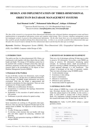
  • 1. IJRET: International Journal of Research in Engineering and Technology eISSN: 2319-1163 | pISSN: 2321-7308 _______________________________________________________________________________________ Volume: 05 Issue: 03 | Mar-2016, Available @ http://www.ijret.org 419 DESIGN AND IMPLEMENTATION OF THREE-DIMENSIONAL OBJECTS IN DATABASE MANAGEMENT SYSTEMS Kazi Shamsul Arefin1* , Mohammed Salim Bhuyan2 , Ashique Al Rahman3 1,2,3 American World University, CA, USA (Bangladesh Study Centre) 1* Research Scholar, ksarefin@yahoo.com, www.ksarefin.info Abstract The idea of this research is to incorporate three-dimensional information into relational database management system and hence implementation in geographical information system and computer aided design. This is because; database management system has inadequate resource to preserve three-dimensional information. On the other hand, there are a lot of potential applications that would be greatly benefited utilizing three-dimensional data. As there is no currently available three-dimensional data type therefore this research leads to identify the three-dimensional objects and develop the data type accordingly. Keywords: Database Management System (DBMS); Three-Dimensional (3D); Geographical Information System (GIS); Geo-DBMS; Computer Aided Design (CAD). --------------------------------------------------------------------***---------------------------------------------------------------------- 1. INTRODUCTION The earth is not flat; it is three-dimensional (3D). Where, we continuously work together with three objects that are width, height and depth. The design of 3D database system has to be satisfied with a number of designs criteria like: data type definition, properties of data types and entities. Finally, this research leads to the development of 3D objects in Geo- Database Management Systems (DBMS). 1.1Statement of the Problem In case of 2D data, we have two dimensions, such as length and width; however, 3D data have an additional dimension, such as height. In DBMS, height information was always overlooked. With this, the height is approximated and included in calculations for these operations. There are some weaknesses for 3D data model in DBMS:  DBMS does not differentiate 3D objects  Inconsistency in continuous flat topology characteristic in GIS systems  Problematic in the execution of spatial analyses in the GIS systems  Problematic to provide solution for spatial overlap 1.2 Objectives of this Research Some researchers are working on 3D geometry data types. However, there are still not recognized 3D data types by the spatial extent in DBMS. The objectives of this research are as follows: 1. To offer 3D data type in DBMS; 2. To develop a data structure that can handle with large data and offers support for analyzing, validation and querying; 3. Propose the next generation topology in DBMS for CAD and geo-DBMS. 2. BENEFITS OF 3D-DBMS DEVELOPMENT There are a lot of advantages utilizing 3D data type in order to preserve 3D information. Now-a-days, some DBMS are trying to preserve 3D information introducing spatial concepts. As mentioned before, depth (Z-coordinate) is ignored or missing in DBMS. Introducing 3D information is a good approach although it is still insufficient. This concept is developed on the basis of geometry models. There are many advantages using 3D DBMS model:  Avoids redundant storage  Consistency in data editing  Easier to maintenance  Efficient in visualization  Efficient in query operations  Natural data model for applications 3. GENERAL DATA TYPE Each column of DBMS has a name with appropriate data type. Developer decides what type of data will be stored inside the column based on the attribute. In this section, a table: T_CITY_INFO is created with 4 (Four) columns: Rank, City, Population, Latitude Longitude and Altitude for this research that leads to the 3D data type in section: 5.0. Illustration 3.1: Table T_CITY_INFO without a spatial geometry column. CREATE TABLE T_CITY_INFO ( Rank NUMBER(4), City VARCHAR2(20 byte), Population NUMBER(10), Latitude NUMBER(10,7), Longitude NUMBER(10,7),
  • 2. IJRET: International Journal of Research in Engineering and Technology eISSN: 2319-1163 | pISSN: 2321-7308 _______________________________________________________________________________________ Volume: 05 Issue: 03 | Mar-2016, Available @ http://www.ijret.org 420 Altitude NUMBER(10,7) ); We gathered GIS information for 140 cities in Bangladesh and inserted data (City name, population, Longitude and Latitude) into T_CITY_INFO. After the execution of ‘INSERT’ statements, ‘COMMIT’ command is placed in order to save into database permanently then data availability is cross-checked using ‘SELECT’ statement. SELECT RANK,CITY,POPULATION,LATITUDE,LONGITUDE from T_CITY_INFO; 3.1 Limitations Now if we would like to preserve information on geographical areas (see Figure 3.1 and 3.2) in the table: T_CITY_INFO then it is not possible in the traditional way. Besides, there is no such data type in oracle database that is able to hold this information. In this case what a traditional DBMS does:  Additional table will be created to preserve information  Use referential keys (Foreign key) in order to make join in different tables Hence, there are some limitations mentioned bellows:  Consuming more memory (Redundant information)  Need to join in both table (Primary and Foreign key)  Perform slower as both not in the same table  Need to indexing in order to fetching data  Complexity in maintaining 2 (two) different physical tables  Complexity in finding related information Fig-3.1: Geographical information of Comilla, Bangladesh 1 1https://www.google.com.bd/maps/place/Comilla Fig-3.2: Geographical information of Mymensingh, Bangladesh2 In the section 4.0: Spatial data type is designed to overcome this issue. 4. SPATIAL DATA TYPE DESIGN Oracle Spatial is incorporated with a set of procedures, functions that supports for 3D data. Spatial data represents the essential location characteristics of real or conceptual objects as those objects relate to the real or conceptual space. Spatial can be stated to:  Dimension  Space  Three-dimensional space In this section, a new column is added in the table: T_CITY_INFO that can hold geographical information then it is tested well with sufficient input operations. The name of that new column is GEO_INFO. It can hold GIS information in the table T_CITY_INFO. ALTER TABLE T_CITY_INFO ADD (GEO_INFO SDO_GEOMETRY); table T_CITY_INFO altered.  Here updating the co-ordinate information as per figure 3.1 for the city of ‘Comilla’. There is an object SDO_ORDINATE_ARRAY in SDO_GEOMETRY where longitude and latitude are being updated. This is how GEO_INFO is holding data. UPDATE T_CITY_INFO SET GEO_INFO = SDO_GEOMETRY( 2https://www.google.com.bd/maps/place/mymensingh
  • 3. IJRET: International Journal of Research in Engineering and Technology eISSN: 2319-1163 | pISSN: 2321-7308 _______________________________________________________________________________________ Volume: 05 Issue: 03 | Mar-2016, Available @ http://www.ijret.org 421 NULL, NULL, NULL, SDO_ELEM_INFO_ARRAY(LONGITUDE, LATITUDE, NULL), SDO_ORDINATE_ARRAY(23.481967, 91.148458, ………………………………………………………………… 23.461970, 91.140046) ) WHERE RANK=64; 1 rows updated.  Now fetching information for the city of ‘Comilla’. Where, GEO_INFO is containing information. SELECT * FROM T_CITY_INFO WHERE RANK=64; RANK CITY POPULATION LATITUDE LONGITUDE GEO_INF0 -------------------------------------------------- 64 Comilla 305700 23.46 91.17 MDSYS.SDO_GEOMETRY(NULL,NULL,NULL,MDSYS.S DO_ELEM_INFO_ARRAY(91.17,23.46,null),MDSYS.SDO_ORD INATE_ARRAY(23.481967,91.148458,23.493361,91.16553 8,23.49102,91.194034,23.461655,91.222014,23.442285 ,91.223302,23.493361,91.165538,23.426771,91.217122 ,23.422676,91.202445,23.423227,91.182361,23.445828 ,91.145024,23.46197,91.140046))  The same procedure is followed to update information of ‘Mymensingh’ city and fetching information of that city. The rank of ‘Mymensingh’ is 85. SELECT * FROM T_CITY_INFO WHERE RANK=85; RANK CITY POPULATION LATITUDE LONGITUDE GEO_INF0 -------------------------------------------------- 85 Mymensingh 244000 24.75 90.4 MDSYS.SDO_GEOMETRY(NULL,NULL,NULL,MDSYS.S DO_ELEM_INFO_ARRAY(90.4,24.75,null),MDSYS.SDO_ORDI NATE_ARRAY(24.782191,90.342722,24.780866,90.362205 ,24.777593,90.370617,24.777533,90.381432,24.770813 ,90.395937,24.75694,90.41482,24.739636,90.42778,24 .728644,90.437393,24.719054,90.448465,24.71422,90. 427523,24.715156,90.406752,24.782191,90.342722,24. 728488,90.395851,24.749224,90.370359,24.765358,90. 359116)) 4.1 Limitations In the figure 3.1 and 3.2 have only two dimensions. There are 2 (two) axis: horizontal and vertical (X and Y) dimensions in two-dimension (2D). However, 3D has one more dimension that is depth (Z). Now if we would like to keep altitude (Z) dimension on geographical area (figure 4.1) in the same table: T_CITY_INFO then it is not possible in this way. As there is no such type of data type in oracle database that can put this information. We can use the oracle spatial objects in order to do that. However, still there are some dependencies and limitations. Such as:  Some DBMSs even do not support the spatial concepts  Inappropriate in data dimensionality and structure In the section 5.0, a custom made 3D data type is designed based on requirements in order to make life easier. Fig-4.1: 3D (Longitude, Latitude and Altitude) Geographical information of Comilla, Bangladesh 5. THREE-DIMENSIONAL DATA TYPE DESIGN In the figure 4.1, we are getting 3D (Longitude, Latitude and Altitude) geographical information for a city. Therefore, a new data type “GEO_3D_OBJ” is developed in order to keep 3D information in this section.  First: an object is created with 3 (three) attributes: Longitude, Latitude and Altitude (properties of these columns are numeric). The name of this object is GEO_3D_ARRAY. CREATE TYPE GEO_3D_ARRAY AS OBJECT ( LONGITUDE NUMBER, LATITUDE NUMBER, ALTITUDE NUMBER);  Second: a varray data type object: GEO_3D_DATA_TYPE is created. Where, VARRAY (1048576) is the maximum size. Here, nested (PL/SQL) table can also be used instead of varray. CREATE TYPE GEO_3D_DATA_TYPE AS VARRAY (1048576) of NUMBER;  Third: a 3D object GEO_3D_OBJ is created where it holds 3 objects (NO_OF_DIM NUMBER,
  • 4. IJRET: International Journal of Research in Engineering and Technology eISSN: 2319-1163 | pISSN: 2321-7308 _______________________________________________________________________________________ Volume: 05 Issue: 03 | Mar-2016, Available @ http://www.ijret.org 422 GEO_3D_DATA_INFO GEO_3D_ARRAY and GEO_3D_DATA GEO_3D_DATA_TYPE). Now this data type (GEO_3D_OBJ) is able to contain 3D information. CREATE TYPE GEO_3D_OBJ AS OBJECT ( NO_OF_DIM NUMBER, GEO_3D_DATA_INFO GEO_3D_ARRAY, GEO_3D_DATA GEO_3D_DATA_TYPE);  Finally: adding 3D column GEO_3D_COL into T_CITY_INFO which is an object of GEO_3D_OBJ ALTER TABLE T_CITY_INFO ADD GEO_3D_COL GEO_3D_OBJ; table T_CITY_INFO altered.  As 3D column is added, now updating information into the newly added GEO_3D_COL column in T_CITY_INFO with 3D information. UPDATE T_CITY_INFO SET GEO_3D_COL = GEO_3D_OBJ( 3, --Number of Dimension GEO_3D_ARRAY(LONGITUDE, LATITUDE, ALTITUDE), GEO_3D_DATA_TYPE( 24.782191, 90.342722, 21, ………………………………………………………………… 24.765358, 90.359116, 20 ) ) WHERE RANK=85; 1 rows updated.  After adding 3D data, checking from T_CITY_INFO for Rank = 85 SELECT RANK, CITY, POPULATION, LATITUDE, LONGITUDE, GEO_3D_COL from T_CITY_INFO WHERE RANK=85; RANK CITY POPULATION LATITUDE LONGITUDE GEO_3D_COL ----------------------------------------------- 85 Mymensingh244000 24.75 90.4 GEO_3D_OBJ(3,GEO_3D_ARRAY(90.4,24.75,NULL ),GEO_3D_DATA_TYPE(24.782191,90.342722,21,24.78 0866,90.362205,19,24.777593,90.370617,17,24.777 533,90.381432,18,24.770813,90.395937,15,24.7569 4,90.41482,12,24.739636,90.42778,19,24.728644,9 0.437393,20,24.719054,90.448465,14,24.71422,90. 427523,16,24.715156,90.406752,20,24.782191,90.3 42722,15,24.728488,90.395851,17,24.749224,90.37 0359,19,24.765358,90.359116,20)) 6.PERFORMANCE ANALYSIS In this section, we analyzed the performance for traditional way and our newly developed 3D data type. Here, we used ‘EXPLAIN PLAN’ for both of cases and found huge performance improvement. 6.1 Traditional Datatype In order to the performance testing, we created 2 (two) additional tables (T_CITY_INFO_TRADITIONAL and GEO_3D_DATA) and did the “EXPLAIN_PLAN” and found the following statistics: EXPLAIN PLAN FOR SELECT T_CITY_INFO_TRADITIONAL.* FROM T_CITY_INFO_TRADITIONAL INNER JOIN GEO_3D_DATA ON GEO_3D_DATA.RANK=T_CITY_INFO_TRADITIONAL.RANK WHERE T_CITY_INFO_TRADITIONAL.RANK=85; SELECT PLAN_TABLE_OUTPUT FROM TABLE(DBMS_XPLAN.DISPLAY()); ----------------------------------------------------- Plan hash value: 3863888095 ----------------------------------------------------- | Id | Operation | Name | Rows | Bytes | Cost (%CPU)| Time | ----------------------------------------------------- | 0 | SELECT STATEMENT | | 15 | 1350 | 7 (15)| 00:00:01 | |* 1 | HASH JOIN | | 15 | 1350 | 7 (15)| 00:00:01 | |* 2 | TABLE ACCESS FULL| T_CITY_INFO_TRADITIONAL | 1 | 77 | 3 (0)| 00:00:01 | |* 3 | TABLE ACCESS FULL| GEO_3D_DATA | 15 | 195 | 3 (0)| 00:00:01 | ----------------------------------------------------- Predicate Information (identified by operation id): --------------------------------------------------- 1 - access("GEO_3D_DATA"."RANK"="T_CITY_INFO_TRADITIONAL" ."RANK") 2 - filter("T_CITY_INFO_TRADITIONAL"."RANK"=85) 3 - filter("GEO_3D_DATA"."RANK"=85) Note ----- - dynamic sampling used for this statement (level=2)
  • 5. IJRET: International Journal of Research in Engineering and Technology eISSN: 2319-1163 | pISSN: 2321-7308 _______________________________________________________________________________________ Volume: 05 Issue: 03 | Mar-2016, Available @ http://www.ijret.org 423 6.2 Developed 3D Datatype In section 5, we developed a 3D data type. Now doing the “EXPLAIN_PLAN” and found the bellow statistics: EXPLAIN PLAN FOR SELECT * FROM T_CITY_INFO WHERE RANK=85; SELECT PLAN_TABLE_OUTPUT FROM TABLE(DBMS_XPLAN.DISPLAY()); ----------------------------------------------------- Plan hash value: 2045439915 ----------------------------------------------------- | Id | Operation | Name | Rows | Bytes | Cost (%CPU)| Time | ----------------------------------------------------- | 0 | SELECT STATEMENT | | 1 | 27 | 3 (0)| 00:00:01 | |* 1 | TABLE ACCESS FULL| T_CITY_INFO | 1 | 27 | 3 (0)| 00:00:01 | ----------------------------------------------------- Predicate Information (identified by operation id): --------------------------------------------------- 1 - filter("RANK"=85) 6.3 Comparisons As per illustration on section 6.1 and 6.2, it is clear the improved performance of our developed 3D data type. We just added our newly developed a 3D column instead of creating a different table what the traditional way followed and got the dramatically performance improvement in terms of Rows, Bytes, Cost (%CPU), Times (Seconds). Table-6.1: Performance analysis of Traditional and newly developed data type Data type Category Traditional 3D (Developed) Improvements (%) Rows 15 1 93% Bytes 1,350 27 98% Cost (%CPU) 7 3 57% Time (Seconds) 1 1 0% Fig-6.1: Performance analysis (Rows, Cost) for traditional and developed 3D data type Fig-6.2: Memory analysis (Bytes) for traditional and developed 3D data type 7. CONCLUSION AND FUTURE RESEARCH In this paper, we presented a clear research evidence of development 3D data type in DBMS. Where, this approach is implemented and contributed to the rising 3D data type for all DBMSs. We can get all information in a single table rather doing multiple pieces and joining from multiple tables; just adding a custom made column able to query. We presented how to develop a custom made data type and also showed how 3D data can be inserted without using existing spatial data type. Hence, it speeds up the process, reduce memory and also easy to manage data. To conclude, our concept is developed, well tested and also provided promising outcomes in Oracle 11g database environment. Future research is to develop 4D data type for Computer Aided Design (CAD) systems using PL/SQL tables. ACKNOWLEDGEMENT This is a unique and interesting research work where it mainly focused geographical area of Bangladesh as this research is done in this country. We would like to thanks google map and Oracle database. Traditional 3D (Developed) Improvements (%) Rows 15 1 93% Cost (%CPU) 7 3 57% Time (seconds) 1 1 0% - 2 4 6 8 10 12 14 16 Performance Improvement Traditional 3D (Developed) Improvements (%) Bytes 1,350 27 98% - 500 1,000 1,500Bytes Memory Improvement
  • 6. IJRET: International Journal of Research in Engineering and Technology eISSN: 2319-1163 | pISSN: 2321-7308 _______________________________________________________________________________________ Volume: 05 Issue: 03 | Mar-2016, Available @ http://www.ijret.org 424 REFERENCES [1] Foley, J., van Dam, A., Feiner, S., and Hughes, J. 1995. Computer graphics: principles and practice. Addison Wesley, 2nd Ed. Geodata Infrastructure North-Rhine Westphalia (GDI NRW). [2] Arens, C. A. 2003. Modeling 3D spatial objects in a geo-DBMS using a 3D primitives. Msc thesis, TU Delft, The Netherlands. 76 p. [3] Arens, C., Stoter, J.E., and van Oosterom, P.J.M. 2005. Modeling 3D spatial objects in a geo-DBMS using a 3D primitive. In Computers & Geosciences, volume 31, 2. pp. 165-177. [4] CalinArens et al., Modeling 3D spatial objects in a geo- DBMS using a 3D primitive, Computers & Geosciences, Vol.31, pp. 165-177, 2005. [5] T.K Chen et al., 3D Spatial Operations for geo-DBMS: Geometry vs. Topology, International Archives of the Photogrammetry and Spatial Information Sciences, Vol.37, pp.549-554, 2008. [6] JantienStoter et al., Visualization and Editing of 3D Objects Organized in a DBMS, Geo-Database Management Center, 2003. [7] JantienStoter et al., 3D Modeling with National Coverage: Bridging the Gap, 3D Products at NMCAs, Open Issues. [8] Prof. Abbas Rajabifard et al., Advance Principles of 3D Cadastral Data Modeling, 2nd International Workshop on 3D Cadastres, 2011. [9] CalinArens et al., Modeling 3D objects in a geo-DBMS using a 3D primitive, 6th AGILE, France, 2003. [10]Narayan, K. Lalit (2008). Computer Aided Design and Manufacturing. New Delhi: Prentice Hall of India. p. 4. ISBN 812033342X. [11]Madsen, David A. (2012). Engineering Drawing & Design. Clifton Park, NY: Delmar. p. 10. ISBN 1111309574. [12]http://en.wikipedia.org/wiki/Spatial [13]http://en.wikipedia.org/wiki/Three-dimensional_space [14]http://en.wikipedia.org/wiki/Data_type BIOGRAPHIES Kazi Shamsul Arefin is engaged in research activities throughout his undergraduate years and has published more than 22 international research papers. Moreover, he is a member of International Association of Computer Science and Information Technology (IACSIT), Membership No: 80337708.