Downloaded 25 times

![6
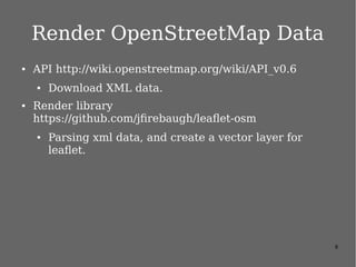
內政部圖資
var osm = new L.OSM.Mapnik();
var nlscmaps = [
// new L.NLSC.PHOTO2({opacity: 0.7}),
new L.NLSC.B5000({opacity: 0.7}),
new L.NLSC.MB5000({opacity: 0.7}),
new L.NLSC.EMAP0({opacity: 0.7}),
new L.NLSC.EMAP1({opacity: 0.7}),
new L.NLSC.EMAP2({opacity: 0.7}),
new L.NLSC.EMAP({opacity: 0.7}),
new L.NLSC.LANDSECT({opacity: 0.7}),
new L.NLSC.Village({opacity: 0.7}),
new L.NLSC.LUIMAP({opacity: 0.7}),
];
var baseMaps = {};
baseMaps[" 開放街圖 "] = osm;
baseMaps[" 正射影像圖 ( 通用版 )"] = new
L.NLSC.PHOTO2({opacity: 1});
var overlayMaps = {};
for (var i in nlscmaps) {
overlayMaps[nlscmaps[i].name] = nlscmaps[i];
}
// set up the map
var map = new L.Map('map', {
center: new L.LatLng( 25.03738, 121.56351 ),
zoom: 17,
layers: [baseMaps[" 正射影像圖 ( 通用版 )"],
overlayMaps[" 通用版電子地圖透明 "]],
} )
.addControl(new L.Control.Scale())
.addControl(new L.Control.Layers(baseMaps,
overlayMaps));
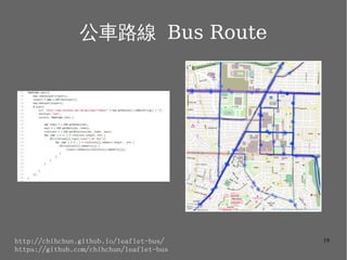
https://github.com/chihchun/leaflet-tw/blob/master/sample/nlsc.html](https://image.slidesharecdn.com/osm-leaflet-140318060408-phpapp02/85/Leaflet-H-H-6-320.jpg)


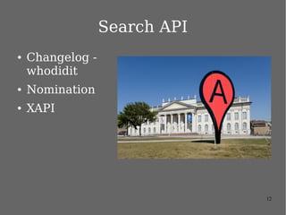

![15
Nomination
● tool to search
OSM data by name
and address and to
generate synthetic
addresses of OSM
points (reverse
geocoding)
● format=[html|xml|json|jsonv2]
● Accept-language=
● q=<uqery>
● countrycodes=<countrycode>
● viewbox=<left>,<top>,<right
>,<bottom>
● bounded=[0|1]
* Nominatim - OpenStreetMap Wiki http://wiki.openstreetmap.org/wiki/Nominatim](https://image.slidesharecdn.com/osm-leaflet-140318060408-phpapp02/85/Leaflet-H-H-15-320.jpg)


The document discusses the use of the Leaflet JavaScript library for creating web maps, particularly for OpenStreetMap data. It highlights various features of Leaflet, including its lightweight nature, customizability through plugins, and support for different map layers. It also provides resources and examples for deploying custom maps and using related APIs for geocoding and data rendering.


![[JSDC 2015] Turf.js - 地理資訊的分析與地圖視覺化](https://cdn.slidesharecdn.com/ss_thumbnails/turfjs-jsdc-151003050030-lva1-app6891-thumbnail.jpg?width=640&height=640&fit=bounds)


![[系列活動] 文字探勘者的入門心法](https://cdn.slidesharecdn.com/ss_thumbnails/textmininghandout-170320140215-170327095320-thumbnail.jpg?width=640&height=640&fit=bounds)


![[DSC 2016] 系列活動:吳牧恩、林佳緯 / 用 R 輕鬆做交易策略分析及自動下單](https://cdn.slidesharecdn.com/ss_thumbnails/tradingwithrcombine-160923053815-thumbnail.jpg?width=640&height=640&fit=bounds)

![[系列活動] 給工程師的統計學及資料分析 123](https://cdn.slidesharecdn.com/ss_thumbnails/0114lckungtdsaprerequisite-170110090917-thumbnail.jpg?width=640&height=640&fit=bounds)


![5G Explained! A High Level Overview [Introduction]](https://cdn.slidesharecdn.com/ss_thumbnails/5gexplainedahighleveloverview-260119165306-cc137a3e-thumbnail.jpg?width=640&height=640&fit=bounds)


