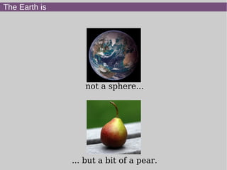
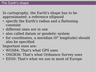
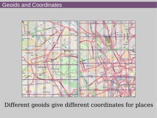
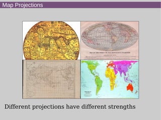
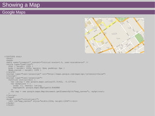
This document summarizes Derick Rethans' presentation on geolocation and maps with PHP. It introduces common geolocation concepts like reference ellipsoids that approximate the Earth's shape, different coordinate systems and map projections. It then demonstrates how to display maps using libraries like Google Maps, OpenLayers, and Leaflet. It also covers geocoding, reverse geocoding, and finding a user's location to center maps. Finally, it provides examples of accessing OpenStreetMap data and using it to find nearby points of interest.


![Showing a Map
OpenLayers
<?xml version="1.0" encoding="iso-8859-1"?>
<!DOCTYPE html PUBLIC "-//W3C//DTD XHTML 1.0 Transitional//EN"
"http://www.w3.org/TR/xhtml1/DTD/xhtml1-transitional.dtd">
<html xmlns="http://www.w3.org/1999/xhtml" lang="EN">
<head>
<style>
html,body { margin: 0; padding: 0; width: 1004px; height: 590px; }
#map { width: 100%; height: 100%; border: 1px solid black; float: left; z-index: -1; }
div.olControlAttribution { bottom: 0.5em; font-size: 70%; }
</style>
<script src='OpenLayers.js'></script>
<script src='osm/OpenStreetMap.js'></script>
<script type="text/javascript">
var map; //complex object of type OpenLayers.Map
var lat=51.51922
var lon=-0.12736
var zoom=17
function init() {
map = new OpenLayers.Map ("map", {
controls:[
new OpenLayers.Control.PanZoomBar(),
new OpenLayers.Control.Attribution()],
projection: new OpenLayers.Projection("EPSG:900913"),
displayProjection: new OpenLayers.Projection("EPSG:4326")
} );
layerMapnik = new OpenLayers.Layer.OSM.Mapnik("Mapnik");
map.addLayer(layerMapnik);
var lonLat = new OpenLayers.LonLat(lon, lat).
transform(map.displayProjection, map.projection);
map.setCenter(lonLat, zoom);
}
</script>
</head>
<body onload="init();">
<div id='map'></div>
</body>
</html>](https://image.slidesharecdn.com/maps-tek11-140613162249-phpapp02/85/Maps-tek11-9-320.jpg)
![Showing a Map
Leaflet
<!DOCTYPE html>
<html>
<head>
<title>Leaflet Quick Start Guide Example</title>
<meta charset="utf-8" />
<link rel="stylesheet" href="leaflet/leaflet.css" />
<!--[if lte IE 8]><link rel="stylesheet" href="leaflet/leaflet.ie.css" /><![endif]-->
<script src="leaflet/leaflet.js"></script>
</head>
<body>
<div id="map" style="width: 1004px; height: 590px"></div>
<script type="text/javascript">
var map = new L.Map('map');
var osmUrl = 'http://{s}.tile.openstreetmap.org/{z}/{x}/{y}.png',
osmAttrib = 'Map data © 2011 OpenStreetMap contributors',
osm = new L.TileLayer(osmUrl, {maxZoom: 18, attribution: osmAttrib});
map.setView(new L.LatLng(51.5179, -0.12), 13).addLayer(osm);
var popup = new L.Popup();
</script>
</body>
</html>](https://image.slidesharecdn.com/maps-tek11-140613162249-phpapp02/85/Maps-tek11-10-320.jpg)
![Showing a Map
Looking up latitude and longitude from a location
<?php
$name = urlencode( ':-:location:-:' );
$baseUrl = 'http://nominatim.openstreetmap.org/search?format=json&q=';
$data = file_get_contents( "{$baseUrl}{$name}&limit=1" );
$json = json_decode( $data );
$lat = $json[0]->lat;
$lon = $json[0]->lon;
?>
var lat=<?php printf( '%0.3f', $lat ); ?>
var lon=<?php printf( '%0.3f', $lon ); ?>
<?php var_dump( $json[0] ); ?>](https://image.slidesharecdn.com/maps-tek11-140613162249-phpapp02/85/Maps-tek11-11-320.jpg)
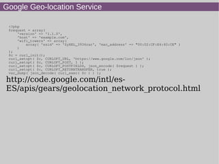
![Looking up latitude/longitude
Different services
● Nominatim:http://nominatim.openstreetmap.org/s
earch?format=json&limit=1&q=London
● Yahoo:http://where.yahooapis.com/geocode?
flags=GJT&appid=[yourappidhere]&q=London](https://image.slidesharecdn.com/maps-tek11-140613162249-phpapp02/85/Maps-tek11-12-320.jpg)
![Finding the user
Using JavaScript to locate the user
function getPosition()
{
navigator.geolocation.getCurrentPosition(iKnowWhereYouAre, notTheFaintestClue,
{timeout:30000});
}
function notTheFaintestClue()
{
}
function iKnowWhereYouAre(position)
{
var lonLat = new OpenLayers.LonLat(
position.coords.longitude, position.coords.latitude
).transform(map.displayProjection, map.projection);
map.setCenter(lonLat, zoom);
center = map.getCenter().
transform(map.getProjectionObject(), new OpenLayers.Projection("EPSG:4326"));
factor = Math.cos(center.lat / (180/Math.PI)), 10 + map.getZoom() * 2;
multiFeature = new OpenLayers.Feature.Vector(
OpenLayers.Geometry.Polygon.createRegularPolygon(
new OpenLayers.Geometry.Point(
center.lon, center.lat
).transform(new OpenLayers.Projection("EPSG:4326"), map.getProjectionObject()),
position.coords.accuracy / factor, 10
),
{
color: 'blue',
align: 'rt'
}
);
vectorLayer.removeAllFeatures();
vectorLayer.drawFeature(multiFeature);
vectorLayer.addFeatures([multiFeature]);
}](https://image.slidesharecdn.com/maps-tek11-140613162249-phpapp02/85/Maps-tek11-15-320.jpg)
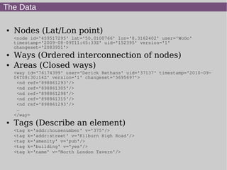
![Fetching OSM data
wget
http://open.mapquestapi.com/xapi/api/0.6/node
[amenity=pub]
[bbox=-2.401,53.394,-2.104,53.551]
-O pubs.osm
<?xml version='1.0' encoding='UTF-8'?>
<osm version='0.6' generator='xapi: OSM Extended API 2.0' attribution='http://wiki.openstreetmap.org/wiki/Attribution'
xmlns:xapi='http://www.informationfreeway.org/xapi/0.6' xapi:uri='/api/0.6/node[amenity=pub][bbox=-2.401,53.394,-
2.104,53.551]' xapi:planetDate='20101006' xapi:copyright='2010 OpenStreetMap contributors' xapi:license='Creative commons
CC-BY-SA 2.0' xapi:bugs='For assistance or to report bugs contact 80n80n@gmail.com' xapi:instance='zappyHyper'>
<bounds minlat='53.394' minlon='-2.401' maxlat='53.551' maxlon='-2.104'/>
<node id='275332052' lat='53.548238' lon='-2.3958373' version='2' changeset='4395635'
user='Steeley' uid='101150' visible='true' timestamp='2010-04-11T17:08:16Z'>
<tag k='amenity' v='pub'/>
<tag k='name' v='The Saddle'/>
</node>
...
<node id='30732192' lat='53.4647746' lon='-2.2319186' version='3' changeset='5810586'
user='geordiemanc' uid='345640' visible='true' timestamp='2010-09-18T11:12:50Z'>
<tag k='address' v='325 Oxford Road'/>
<tag k='amenity' v='pub'/>
<tag k='name' v='Kro Bar'/>
<tag k='phone' v='01612743100'/>
<tag k='postal_code' v='M13 9PG'/>
<tag k='real_ale' v='yes'/>
</node>](https://image.slidesharecdn.com/maps-tek11-140613162249-phpapp02/85/Maps-tek11-18-320.jpg)
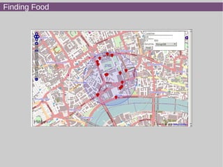
![Finding Food
function init() {
map = new OpenLayers.Map ("map", {
eventListeners: {
"moveend": moveEndEvent
},
controls:[
function changeQuery()
{
cuisine = document.getElementById('amenity').value;
radiusInput = document.getElementById('radius');
source = document.getElementById('source').value;
if (source == 'sqlite') { script = 'fetch.php'; }
if (source == 'mysql') { script = 'fetch-mysql.php'; }
if (source == 'mongo') { script = 'fetch-mongo.php'; }
if (source == 'mongo2') { script = 'fetch-mongo-fixed.php'; }
center = map.getCenter().transform(map.getProjectionObject(), new OpenLayers.Projection("EPSG:4326"));
pois.destroy();
pois = new OpenLayers.Layer.Text( "The Shops", {
location: "./" + script + "?cuisine=" + cuisine +
'&lat=' + center.lat + '&lon=' + center.lon + '&d=' + radiusInput.value,
projection: map.displayProjection
});
map.addLayer(pois);
multiFeature = new OpenLayers.Feature.Vector(
OpenLayers.Geometry.Polygon.createRegularPolygon(
new OpenLayers.Geometry.Point(center.lon,center.lat).transform(new OpenLayers.Projection("EPSG:4326"),
map.getProjectionObject()),
radiusInput.value * 1000 / Math.cos(center.lat / (180/Math.PI)), 10 + map.getZoom() * 2, 10
),
{
color: 'blue',
align: 'rt'
});
vectorLayer.removeAllFeatures();
vectorLayer.drawFeature(multiFeature);
vectorLayer.addFeatures([multiFeature]);
}
function moveEndEvent(event)
{
changeQuery();
}](https://image.slidesharecdn.com/maps-tek11-140613162249-phpapp02/85/Maps-tek11-21-320.jpg)
![Finding Food
Getting The Data: SQLite
<?php
include 'distance.php';
header('Content-type: text/plain');
require '/home/derick/dev/zetacomponents/trunk/Base/src/ezc_bootstrap.php';
$d = ezcDbFactory::create( 'sqlite://' . dirname( __FILE__ ) . '/pois.sqlite' );
$wantedD = isset($_GET['d']) ? $_GET['d']: 1;
$q = $d->createSelectQuery();
$q->select('*')->from('poi');
if ( $_GET['cuisine'] !== 'all' )
{
$q->where($q->expr->eq('cuisine', $q->bindValue( $_GET['cuisine'] ) ) );
}
$s = $q->prepare();
$s->execute();
echo "lattlonttitletdescriptionticonSizeticonOffsetticonrn";
foreach( $s as $res) {
$e = distance2($_GET['lat'], $_GET['lon'], $res['lat'], $res['lon'] );
if ($e < $wantedD) {
echo $res['lat'], "t", $res['lon'], "t", $res['name'], "t", sprintf('%.2f', $e). " km awayt16,16t-8,-
8tpub.pngrn";
}
}
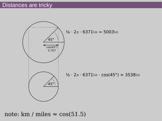
Calculating Distance
<?php
function distance2($latA, $lonA, $latB, $lonB)
{
$latA = deg2rad($latA);
$lonA = deg2rad($lonA);
$latB = deg2rad($latB);
$lonB = deg2rad($lonB);
$deltaLat = ($latA - $latB);
$deltaLon = ($lonA - $lonB);
$d = sin($deltaLat/2) * sin($deltaLat/2) +
cos($latA) * cos($latB) * sin($deltaLon/2) * sin($deltaLon/2);
$d = 2 * asin(sqrt($d));
return $d * 6371.01;
}
See also: http://drck.me/spat-osm-sqlite-8la](https://image.slidesharecdn.com/maps-tek11-140613162249-phpapp02/85/Maps-tek11-23-320.jpg)
![Finding Food
Getting The Data: MySQL
<?php
include 'distance.php';
header('Content-type: text/plain');
require '/home/derick/dev/zetacomponents/trunk/Base/src/ezc_bootstrap.php';
$d = ezcDbFactory::create( 'mysql://root:root@localhost/geolocation' );
$wantedD = isset($_GET['d']) ? $_GET['d']: 1;
$q = $d->createSelectQuery();
$q->select('*',"DISTANCE({$_GET['lat']},{$_GET['lon']}, lat, lon) as dist")->from('poi');
if ( $_GET['cuisine'] !== 'all' )
{
$q->where($q->expr->eq('cuisine', $q->bindValue( $_GET['cuisine'] ) ) );
}
$s = $q->prepare();
$s->execute();
Stored Procedure
delimiter //
CREATE FUNCTION distance (latA double, lonA double, latB double, LonB double)
RETURNS double DETERMINISTIC
BEGIN
SET @RlatA = radians(latA);
SET @RlonA = radians(lonA);
SET @RlatB = radians(latB);
SET @RlonB = radians(LonB);
SET @deltaLat = @RlatA - @RlatB;
SET @deltaLon = @RlonA - @RlonB;
SET @d = SIN(@deltaLat/2) * SIN(@deltaLat/2) +
COS(@RlatA) * COS(@RlatB) * SIN(@deltaLon/2)*SIN(@deltaLon/2);
RETURN 2 * ASIN(SQRT(@d)) * 6371.01;
END//
See also: http://drck.me/spat-mysql-8ls](https://image.slidesharecdn.com/maps-tek11-140613162249-phpapp02/85/Maps-tek11-24-320.jpg)
![Finding Food
Getting The Data: MongoDB
<?php
header('Content-type: text/plain');
$m = new Mongo( 'mongodb://localhost:27017' );
$d = $m->selectDb( 'geolocation' );
$wantedD = isset($_GET['d']) ? $_GET['d']: 1;
$query = array( 'cuisine' => $_GET['cuisine'] );
if ( $_GET['cuisine'] == 'all' )
{
$query = array();
}
$s = $d->command(
array(
'geoNear' => 'poi',
'near' => array( $_GET['lat'], $_GET['lon'] ),
'num' => 10000,
'maxDistance' => $wantedD * (360 / (2*M_PI*6371.01)), // km to °
'query' => $query,
)
);
echo "lattlonttitletdescriptionrn";
foreach( $s['results'] as $res) {
if (isset($res['obj']['name'] ) )
{
echo $res['obj']['loc'][0], "t", $res['obj']['loc'][1], "t", $res['obj']['name'], "t", sprintf('real: %.4f mongo:
%.4f', $e, $res['dis'] / (360 / (2*M_PI*6371.
}
}
Spatial Index
db.poi.ensureIndex( { poi : '2d' } );
$s = $d->command(
array(
'geoNear' => 'poi',
'near' => array( $_GET['lat'], $_GET['lon'] ),
'num' => 10000,
'maxDistance' => $wantedD * (360 / (2*M_PI*6371.01)), // km to °
'query' => $query,
)
);
Geospatial Index (since 1.7)](https://image.slidesharecdn.com/maps-tek11-140613162249-phpapp02/85/Maps-tek11-26-320.jpg)
![Flickr
function newImageMarker(url, lat, lon)
{
w = 85 - ((19-map.getZoom())*4);
size = new OpenLayers.Size(w,w);
offset = new OpenLayers.Pixel(-(size.w/2), -(size.h/2));
icon = new OpenLayers.Icon(url, size, offset);
marker = new OpenLayers.Marker(
new OpenLayers.LonLat(lon, lat)
.transform(
new OpenLayers.Projection("EPSG:4326"),
map.getProjectionObject()
),
icon.clone()
);
marker.events.register(
'mousedown',
marker,
function(evt) { showImage(this.icon); OpenLayers.Event.stop(evt); }
);
markers.addMarker(marker);
}
function changeQuery()
{
markers.clearMarkers();
$.getJSON('fetch-flickr.php', function(data) {
$.each(data.items, function(i,item){
newImageMarker(item.url, item.lat, item.lon);
});
});
}
<?php
$d = ezcDbFactory::create( 'sqlite://' . dirname( __FILE__ ) . '/presentations/slides/map/examples/photos.sqlite' );
$q = $d->createSelectQuery();
$q->select('*')->from('photo')->orderBy( 'date_taken', ezcQuerySelect::DESC )->limit(100);
$s = $q->prepare();
$s->execute();
$items = array();
foreach ( $s as $photo )
{
$items[] = array(
'lon' => $photo['lon'],
'lat' => $photo['lat'],
'url' => $photo['thumb_url']
);
}
echo json_encode(array( 'items' => $items ) );](https://image.slidesharecdn.com/maps-tek11-140613162249-phpapp02/85/Maps-tek11-27-320.jpg)
![Getting the WLAN info
<?php
define( 'NM', "org.freedesktop.NetworkManager" );
$d = new Dbus( Dbus::BUS_SYSTEM, true );
$n = $d->createProxy( NM, "/org/freedesktop/NetworkManager", NM);
$wifi = array();
foreach ($n->GetDevices()->getData() as $device)
{
$device = $device->getData();
$dev = $d->createProxy( NM, $device, "org.freedesktop.DBus.Properties");
$type = $dev->Get(NM . ".Device", "DeviceType")->getData();
if ( $type == 2 ) // WI-FI
{
$wifiDev = $d->createProxy(NM, $device, NM . ".Device.Wireless");
foreach( $wifiDev->GetAccessPoints()->getData() as $ap )
{
$apDev = $d->createProxy(NM, $ap->getData(), "org.freedesktop.DBus.Properties");
$props = $apDev->GetAll(NM . ".AccessPoint")->getData();
$ssid = '';
foreach( $props['Ssid']->getData()->getData() as $n )
{
$ssid .= chr($n);
}
$wifi[] = array('ssid' => $ssid, "mac_address" => $props['HwAddress']->getData() );
}
}
}
$request = array( 'version' => '1.1.0', 'host' => 'example.com', 'wifi_towers' => $wifi );
$c = curl_init();
curl_setopt( $c, CURLOPT_URL, 'https://www.google.com/loc/json' );
curl_setopt( $c, CURLOPT_POST, 1 );
curl_setopt( $c, CURLOPT_POSTFIELDS, json_encode( $request ) );
curl_setopt( $c, CURLOPT_RETURNTRANSFER, true );
$result = json_decode( curl_exec( $c ) )->location;
echo "<a href='http://openstreetmap.org/?lat={$result->latitude}&lon={$result->longitude}&zoom=18'>here</a>n";
?>](https://image.slidesharecdn.com/maps-tek11-140613162249-phpapp02/85/Maps-tek11-29-320.jpg)