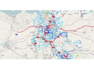
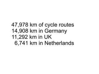
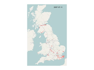
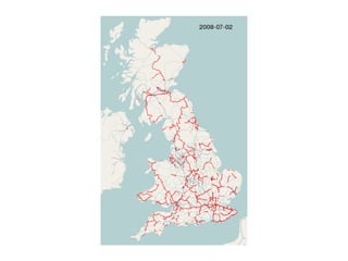
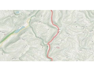
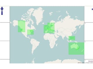
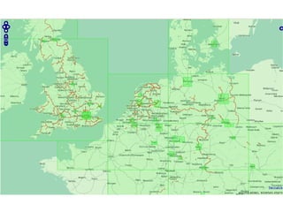
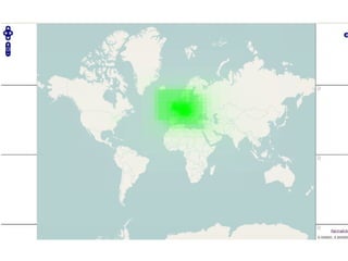
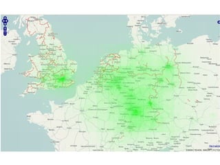
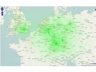
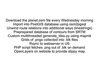
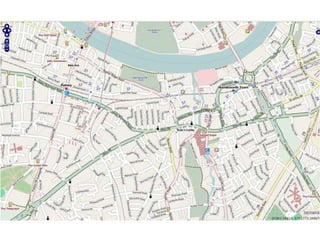
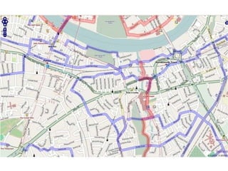
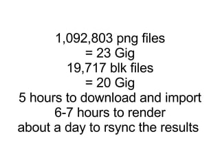
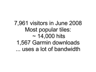
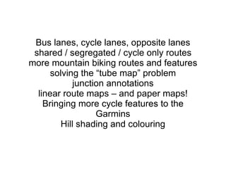
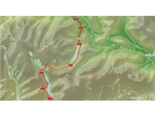
The document summarizes the OpenStreetMap cycle map, which contains over 47,000 km of mapped cycle routes. It describes how the map is generated from OpenStreetMap data and rendered into image tiles, then hosted on a website. Over 1 million image tiles totaling 23 GB are generated, taking around 5-6 hours. In June 2008, there were nearly 8,000 visitors to the site. Future plans include adding more detailed cycling route information and developing printed map versions.
Creating and indoor routable network with QGIS and pgRoutingRoss McDonald
Tim Manner from Ordnance Survey explains how they created an indoor routable network using QGIS and pgRouting. In 3D using QGIS2ThreeJS to build an interactive map with live routing.
Building a developer community with containersRex Tsai
This talk shared about why Taiwan hiking community needs to build their own osm map, and how the docker images can help them to build maps. The talk is presented at SoTM Asia 2016
OpenGeoData Italia - Roma - Simone Cortesi | Maurizio Napolitano | openstreet...Simone Cortesi
Discussione su OpenStreetMap, sistemi GIS classici, confronti, potenzialità di OSM e dei suoi strumenti di estrazione dati.
Slide per la conferenza OpenGeoData Italia - Roma - 27 febbraio 2014.
More and more cities, regions and countries gather point cloud data through airborne Lidar sensors. We explain what is point cloud data, discuss Flanders' large point cloud and the challenges that pose the task of computing a 3D model for each building in Flanders.
High Performance OSM Data Manipulation With Osmium - State of the Map 2013OSMFstateofthemap
*** Presented by Jochen Topf at State of the Map 2013
*** For the video of this presentation please see http://lanyrd.com/2013/sotm/scpkqw/
*** Full schedule available at http://wiki.openstreetmap.org/wiki/State_Of_The_Map_2013
Osmium is a highly flexible and performant C++ library for working with OpenStreetMap data. It helps with reading, writing, and filtering OSM data, OSM history data and OSM change files in XML or PBF format. Osmium assembles way and (multi)polygon geometries and converts them into many GIS formats such as shapefiles. It also contains code to store OSM data efficiently and much more. All of this in an easy to use C++ header-only library. Some functions are also available from Javascript to make it's use even easier. The talks shows what we have learned over the years about high- performance OSM data manipulation, the current state of Osmium and what the future might bring.
Loader and Tester Swarming Drones for Cellular Phone Network Loading and Fiel...Amir MirzaeiNia
Cellular network operators have problems to test their network without affecting their user experience. Testing network performance in a loaded situation is a challenge for the network operator because network performance differs when it has more load on the radio access part. Therefore, in this paper, deploying swarming drones is proposed to load the cellular network and scan/test the network performance more realistically. Besides, manual swarming drone navigation is not efficient enough to detect problematic regions. Hence, particle swarm optimization is proposed to be deployed on swarming drone to find the regions where there are performance issues. Swarming drone communications helps to deploy the particle swarm optimization (PSO) method on them. Loading and testing swarm separation help to have almost non-stochastic received signal level as an objective function. Moreover, there are some situations that more than one network parameter should be used to find a problematic region in the cellular network. It is also proposed to apply multi-objective PSO to find more multi-parameter network optimization at the same time.
Geopaparazzi is an application for fast field surveys. Its simplicity and the possibility to use it on as good as any android smartphone makes it a trusty field companion for engineers and geologists, but also for tourists who wish to keep a geodiary and any user that needs to be aware of his position even in offline mode.
In Geopaparazzi it is possible to create text, picture and sketch notes and place them on the map. Notes can also be complex and form based in order to standardize surveys in which many people need to be coordinated.
In the last years the support for the visualization of spatialite vector layers and recently also editing possibilities for spatialite poligonal datasets has been added, allowing for some simple-yet-powerfull possibilities on vector data. Desktop tools are supplied to bring datasets from the GIS environment to Geopaparazzi and back.
The presentation will focus on the most important features of Geopaparazzi as well as the latest additions to the application in order to give a complete idea of the state of the art of the project.
CycleStreets: Our Story - presentation to Net2Camb eventCycleStreets
Here is our presentation at the Net2Camb event.
See:
http://www.cyclestreets.net/blog/2010/12/29/net2camb-meetup-building-cyclestreets/
http://net2camb.org/2011/01/january-net2camb-meetup-building-cyclestreets/
TransportCamp AU Presentation: Designing a multimodal, high-frequency network...Patrick Sunter
My presentation at the inaugural TransportCampAU in Melbourne, Nov 1 (http://www.transportcamp.org.au/events/transportcamp-melbourne-2014) about work with Beyond Zero Emissions (http://bze.org.au/) to design a high-frequency bus network, assisted by open source tools such as OpenTripPlanner.
Network Based Kernel Density Estimation for Cycling Facilities Optimal Locati...Beniamino Murgante
Network Based Kernel Density Estimation for Cycling Facilities Optimal Location Applied to Ljubljana
Nicolas Lachance-Bernard, Timothée Produit - Ecole polytechnique fédérale de Lausanne
Biba Tominc, Matej Niksic, Barbara Golicnik Marusic - Urban Planning Institute of the Republic of Slovenia
Building maps for apps in the cloud - a Softlayer Use CaseTiman Rebel
Together with Softlayer Snowciety gave a presentation at GOTO Amsterdam 2013 about building custom maps using OpenStreetMap and SRTM data, POstgis/PostgreSQL as a datsbase, Mapnik as a renderer, Tilestance and Apache as the http servers and Leaflet as the javascript client.
This presentation covers architectural principles for Software defined "Everything", Microservices - their impact on Azure, a Geo-Spatial Fleet analysis using Spark and HDFS on ESRI and FlowBasedProgramming
OpenStreetMap and CycleStreets: collaborative map-making and cartography in t...CycleStreets
Abstract: The arrival of web-based mapping from Google and others has revolutionised, in the space of only five years, the way many people interact with maps and map data. And the success of projects such as Wikipedia highlight how collation of small amounts of information from large numbers of people - an approach called 'crowdsourcing' - can challenge traditional models of data collection and ownership. Bringing these concepts together is OpenStreetMap, a collaborative project to create a free editable map of the world. Well-established enterprises such as the Ordnance Survey are coming under increased pressure from this new model, and large companies such as MapQuest and Microsoft are starting to use and invest in it. Martin Lucas-Smith, Webmaster in the Department, and one of two main developers of the leading UK-wide cycle journey planner website, CycleStreets, will discuss OpenStreetMap, its use within a wide range of systems (from cartography, routing, and even its central role helping deal with the Haiti disaster) and discuss the challenges it poses to traditional forms of cartography and data collection.
Generating a custom Ruby SDK for your web service or Rails API using Smithyg2nightmarescribd
Have you ever wanted a Ruby client API to communicate with your web service? Smithy is a protocol-agnostic language for defining services and SDKs. Smithy Ruby is an implementation of Smithy that generates a Ruby SDK using a Smithy model. In this talk, we will explore Smithy and Smithy Ruby to learn how to generate custom feature-rich SDKs that can communicate with any web service, such as a Rails JSON API.
Encryption in Microsoft 365 - ExpertsLive Netherlands 2024Albert Hoitingh
In this session I delve into the encryption technology used in Microsoft 365 and Microsoft Purview. Including the concepts of Customer Key and Double Key Encryption.
GDG Cloud Southlake #33: Boule & Rebala: Effective AppSec in SDLC using Deplo...James Anderson
Effective Application Security in Software Delivery lifecycle using Deployment Firewall and DBOM
The modern software delivery process (or the CI/CD process) includes many tools, distributed teams, open-source code, and cloud platforms. Constant focus on speed to release software to market, along with the traditional slow and manual security checks has caused gaps in continuous security as an important piece in the software supply chain. Today organizations feel more susceptible to external and internal cyber threats due to the vast attack surface in their applications supply chain and the lack of end-to-end governance and risk management.
The software team must secure its software delivery process to avoid vulnerability and security breaches. This needs to be achieved with existing tool chains and without extensive rework of the delivery processes. This talk will present strategies and techniques for providing visibility into the true risk of the existing vulnerabilities, preventing the introduction of security issues in the software, resolving vulnerabilities in production environments quickly, and capturing the deployment bill of materials (DBOM).
Speakers:
Bob Boule
Robert Boule is a technology enthusiast with PASSION for technology and making things work along with a knack for helping others understand how things work. He comes with around 20 years of solution engineering experience in application security, software continuous delivery, and SaaS platforms. He is known for his dynamic presentations in CI/CD and application security integrated in software delivery lifecycle.
Gopinath Rebala
Gopinath Rebala is the CTO of OpsMx, where he has overall responsibility for the machine learning and data processing architectures for Secure Software Delivery. Gopi also has a strong connection with our customers, leading design and architecture for strategic implementations. Gopi is a frequent speaker and well-known leader in continuous delivery and integrating security into software delivery.
The Art of the Pitch: WordPress Relationships and SalesLaura Byrne
Clients don’t know what they don’t know. What web solutions are right for them? How does WordPress come into the picture? How do you make sure you understand scope and timeline? What do you do if sometime changes?
All these questions and more will be explored as we talk about matching clients’ needs with what your agency offers without pulling teeth or pulling your hair out. Practical tips, and strategies for successful relationship building that leads to closing the deal.
GraphRAG is All You need? LLM & Knowledge GraphGuy Korland
Guy Korland, CEO and Co-founder of FalkorDB, will review two articles on the integration of language models with knowledge graphs.
1. Unifying Large Language Models and Knowledge Graphs: A Roadmap.
https://arxiv.org/abs/2306.08302
2. Microsoft Research's GraphRAG paper and a review paper on various uses of knowledge graphs:
https://www.microsoft.com/en-us/research/blog/graphrag-unlocking-llm-discovery-on-narrative-private-data/
Essentials of Automations: Optimizing FME Workflows with ParametersSafe Software
Are you looking to streamline your workflows and boost your projects’ efficiency? Do you find yourself searching for ways to add flexibility and control over your FME workflows? If so, you’re in the right place.
Join us for an insightful dive into the world of FME parameters, a critical element in optimizing workflow efficiency. This webinar marks the beginning of our three-part “Essentials of Automation” series. This first webinar is designed to equip you with the knowledge and skills to utilize parameters effectively: enhancing the flexibility, maintainability, and user control of your FME projects.
Here’s what you’ll gain:
- Essentials of FME Parameters: Understand the pivotal role of parameters, including Reader/Writer, Transformer, User, and FME Flow categories. Discover how they are the key to unlocking automation and optimization within your workflows.
- Practical Applications in FME Form: Delve into key user parameter types including choice, connections, and file URLs. Allow users to control how a workflow runs, making your workflows more reusable. Learn to import values and deliver the best user experience for your workflows while enhancing accuracy.
- Optimization Strategies in FME Flow: Explore the creation and strategic deployment of parameters in FME Flow, including the use of deployment and geometry parameters, to maximize workflow efficiency.
- Pro Tips for Success: Gain insights on parameterizing connections and leveraging new features like Conditional Visibility for clarity and simplicity.
We’ll wrap up with a glimpse into future webinars, followed by a Q&A session to address your specific questions surrounding this topic.
Don’t miss this opportunity to elevate your FME expertise and drive your projects to new heights of efficiency.
Epistemic Interaction - tuning interfaces to provide information for AI supportAlan Dix
Paper presented at SYNERGY workshop at AVI 2024, Genoa, Italy. 3rd June 2024
https://alandix.com/academic/papers/synergy2024-epistemic/
As machine learning integrates deeper into human-computer interactions, the concept of epistemic interaction emerges, aiming to refine these interactions to enhance system adaptability. This approach encourages minor, intentional adjustments in user behaviour to enrich the data available for system learning. This paper introduces epistemic interaction within the context of human-system communication, illustrating how deliberate interaction design can improve system understanding and adaptation. Through concrete examples, we demonstrate the potential of epistemic interaction to significantly advance human-computer interaction by leveraging intuitive human communication strategies to inform system design and functionality, offering a novel pathway for enriching user-system engagements.
Transcript: Selling digital books in 2024: Insights from industry leaders - T...BookNet Canada
The publishing industry has been selling digital audiobooks and ebooks for over a decade and has found its groove. What’s changed? What has stayed the same? Where do we go from here? Join a group of leading sales peers from across the industry for a conversation about the lessons learned since the popularization of digital books, best practices, digital book supply chain management, and more.
Link to video recording: https://bnctechforum.ca/sessions/selling-digital-books-in-2024-insights-from-industry-leaders/
Presented by BookNet Canada on May 28, 2024, with support from the Department of Canadian Heritage.
18. Download the planet.osm file every Wednesday morning Import into PostGIS database using osm2pgsql Unwind route relations into additional ways (linestrings) Preprepared database of contours from SRTM Custom multithreaded generate_tiles.py using mapnik Grids of .pngs collected into .blk files Rsync to webserver in US PHP script fetches .png out of .blk on demand OpenLayers on website to provide slippy map
31. Bus lanes, cycle lanes, opposite lanes shared / segregated / cycle only routes more mountain biking routes and features solving the “tube map” problem junction annotations linear route maps – and paper maps! Bringing more cycle features to the Garmins Hill shading and colouring