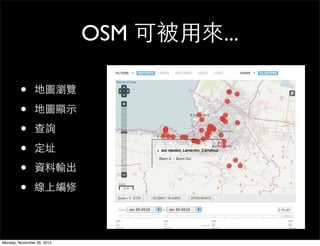
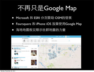
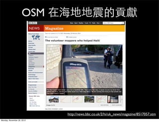
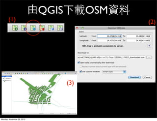
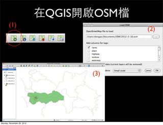
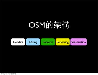
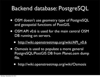
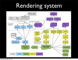
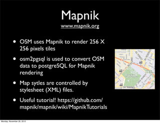
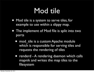
The document discusses OpenStreetMap (OSM), an open-source project to create a free editable map of the world. It provides an overview of OSM, including how it allows users to collect and share geographic information online. It also describes how OSM data can be edited using tools on both desktop and mobile, and how the data is rendered into map tiles and stored in a backend database for public use.
DSD-INT 2016 A crowd-sourced spatial database can change the way we work - Va...Deltares
Presentation by Ben van Kester (Deltares) at Earth Observation and Data Science Symposium, during Delft Software Days 2016. Monday 24 October 2016, Delft.
The document discusses the benefits of exercise for mental health. Regular physical activity can help reduce anxiety and depression and improve mood and cognitive function. Exercise causes chemical changes in the brain that may help protect against mental illness and improve symptoms.
The document provides an overview of OpenStreetMap (OSM) including that it is a free and open map of the world created from crowdsourced data. It describes how OSM uses a wiki-style model for mappers to collect and edit geographic information. The document then outlines the basic steps mappers should follow which include preparing with tools like GPS, collecting data in the field, uploading GPS traces, and using an editor to map locations and add tags.
This document provides an overview of OpenStreetMap (OSM), including its major components, mapping techniques, data sources, editing tools, and rendering systems. OSM is a collaborative project that allows volunteers to collect and edit geographic map data that is made publicly available under an open license. Mappers can contribute data through GPS traces, photos, or paper maps, and edit map features using online or offline editors. OSM data is stored in a PostgreSQL database and rendered into tiles using Mapnik for display on websites and mobile apps through a "slippy map" interface.
As we move further into the future of digital design, web design is no longer just about creating a single great desktop browsing experience. The interactive design industry is at a crossroads; mobile and tablet devices continue to propagate and fuel new interactions, and the web is now found on more devices than ever.
So, how do we adjust accordingly? More often than not, designers and programmers use old methodologies to tackle new problems. The real tool kit of a great web designer starts off-line and off-screen. This lecture will showcase important skills that will prepare flexible designs for future facing web projects. We will outline a set of new philosophies, collaborative processes and custom tools that enable productivity in this ever-changing world. We'll also cover the importance of creating your own tools and adapting to new needs, so you can stay ahead of the game.
By demonstrating the right workflow, the right tools and a future facing philosophy, this talk aims to help anyone who has thought to themselves: 'there has to be a better way'. The future isn't 12-column grids and pixel perfect PSDs. It's a flexible thinking model that relies on your understanding of development and a strong design philosophy.
Things we have learned so far and what we'd like to do in the future as data ...Small Multiples
This document summarizes techniques and approaches for data visualization design that were presented at the Hacks/Hackers event on October 30th, 2012. It discusses conducting research on precedents, rapid prototyping to find stories in data, brainstorming visualization concepts, and developing visualizations using technologies like Django, FusionTables API, Tilemill, and Google Maps API. Examples of completed projects like the SBS Census Explorer and mockups of sensor data visualizations are also presented. The presentation concludes by discussing how data visualization is becoming an interactive platform rather than just an endpoint.
This document discusses open source GIS and modeling tools. It covers topics like addressing the map changing problem, defining temporal spatial databases, and integrated modeling and spatial data. Open formats, modeling, and the OGC and OPEN MI partnership are also mentioned. Spatial enabled services, standards, and the map changing problem are summarized. The document provides examples and diagrams about OPEN MI, model linking, and supporting open source tools and communities. Future steps discussed include parallel computing modeling, model optimization, and linking sensors and models.
The document discusses presenting cultural heritage online and the challenges of visualizing bibliographic data. It describes current visualization approaches in library systems, non-library systems, and non-commercial projects. Issues with visualizing large amounts of cultural data are examined. The discussion focuses on using linked data and visualizing only what is appropriate through techniques like interactive timelines and contextual relationships between entities.
This document discusses data-driven smart governance and describes how governments can utilize data, information, and intelligence through interaction, integration, and influence. It provides examples of how open data, data standards, semantic technologies, machine learning, and public-private partnerships can help power more data-driven decision making and transparent, responsive government services.
The methods and practices of Linked Open DataDongpo Deng
This document discusses various topics related to linked open data and semantic web technologies for agriculture data. It provides examples of Taiwan's open agriculture datasets published as linked data online, and how standards like schema.org can be used to markup recipe data on the web. It also summarizes efforts to build applications and services that integrate agriculture data from different sources using semantic web technologies.
Construction and reuse of linked traceable agricultural product records - An ...Dongpo Deng
This document discusses linking open agricultural product traceability data from Taiwan to create a linked data cloud. It describes the Traceable Agricultural Product (TAP) data format, processing the data to extract and standardize crop names, geocode locations, and map the data to an Agriculture Activity Ontology. SPARQL endpoints were created to query linked data from farms, stores, and restaurants using TAP data. A Chrome extension was developed for federated SPARQL queries across these datasets.
The European Data Forum 2016 discussed the European Commission's 2012 agenda to create a Connected Digital Single Market and promote Open Data, Linked Data, and Big Data to develop the EU's Data Economy. The forum explored how data and digital technologies can support the Digital Economy and Society and help small- and medium-sized enterprises utilize data.
From Structured Data to Linked Open Governmental DataDongpo Deng
This document discusses linked open data and publishing government data as linked open data. It provides an overview of linked open data principles and standards like URIs, RDF, and SPARQL. It also shares lessons learned from linked open data implementations by governments worldwide and the benefits of exposing data to larger audiences through linked open data. Key challenges include selecting appropriate ontologies and establishing links between data from different sources and domains.
Crowdsourced mapping for open collaboration: A story of Taiwan so farDongpo Deng
The slides presented in State of the Map Japan 2014 mainly introduced the development status of the OSM Taiwan community, and the idea of community mapping is implemented in Taiwan.
Dongpo Deng attended the Linked Data on the Web 2014 workshop and WWW 2014 conference in Seoul from April 7-12. Some key highlights included:
- He stayed in a reasonably priced hotel close to the metro that had small rooms and noise until 2pm.
- At LDOW 2014 he attended sessions on integration, exploration, and applications of linked data that featured talks on topics like RML mappings, DBpedia exploration, and crowdsourced sensor data.
- WWW 2014 had over 600 submissions across 11 areas with a 13% acceptance rate. The keynotes covered graph mining, organizing the digital world, and taming the web.
- Dongpo attended talks on crowds
Toward Next Generation of Gazetteer: Utilizing GeoSPARQL For Developing Link...Dongpo Deng
This document summarizes Dongpo Deng's presentation on developing linked geoname data using GeoSPARQL. It discusses transforming a Taiwanese place name dataset into RDF triples using a place name ontology. A linked data server and GeoSPARQL endpoint were created to serve and query the linked place name data. Spatial and temporal SPARQL queries over the data were demonstrated. The linked place names can be used as controlled vocabularies and are connected to other datasets like Geonames.org.
The document discusses how crowdsourced data from platforms like OpenStreetMap, Safecast, and social media can be used to address the impacts of climate change. OpenStreetMap allows anyone to collaboratively map the world and proved useful in mapping areas affected by the 2010 Haiti earthquake within weeks. Safecast crowdsources radiation level data with mobile devices and geiger counters to empower people with information. Social media platforms like Flickr have also been used to track phenomena like changing cherry blossom seasons that may be influenced by climate change. The document argues these informal sources can help collect scientific data and monitor climate impacts in a structured way.
This document discusses open geospatial data and engaging citizens in spatial data infrastructures (SDI). It defines open data and open geospatial data. It notes that while grassroots communities in Taiwan are active in open data, there is a lack of high-level policies. The document advocates for governments to act as platforms rather than vendors of data. It outlines different funding models and proposes a 4P approach (Policy, Principle, Process, Price) for open geospatial data. It highlights examples of engaging citizens from other countries and proposes actions Taiwan could take to open data and involve citizens in its SDI.
Social Web Meets Sensor Web: Linked Crowdsourced Observation DataDongpo Deng
This document discusses linking data from biodiversity observations on platforms like Galaxy Zoo, Audubon, and iNaturalist to semantic web standards like the Semantic Sensor Network ontology. It presents an example observation of a Chinese ferret badger from Taiwan expressed using these linked data formats and ontologies. The example includes details on the observation provider, photo, date, location, and taxonomic identification. It also shows SPARQL queries that could be used to retrieve observations from a specific place and time period.
43. 由QGIS下載OSM資料
(1) (2)
(3)
Monday, November 26, 2012
44. 在QGIS開啟OSM檔
(1)
(2)
(3)
Monday, November 26, 2012
45. 智慧型手機中Apps
• Apple iOS
• iPhone, e.g. iLOE
• Andriod
• e.g.Vespucci OSM Editor
See more details http://wiki.openstreetmap.org/wiki/Software
Monday, November 26, 2012
54. Backend database: PostgreSQL
• OSM doesn’t use geometry type of PostgreSQL
and geospatial functions of PostGIS.
• OSM API v0.6 is used for the main central OSM
DB running on servers.
• http://wiki.openstreetmap.org/wiki/API_v0.6
• Osmosis is used to populate a more general
PostgreSQL/PostGIS DB from Planet.osm dump
file.
• http://wiki.openstreetmap.org/wiki/Osmosis
Monday, November 26, 2012
56. Mapnik
www.mapnik.org
• OSM uses Mapnik to render 256 X
256 pixels tiles
• osm2pgsql is used to convert OSM
data to postgreSQL for Mapnik
rendering
• Map sytles are controlled by
stylesheet (XML) files.
• Useful tutorial! https://github.com/
mapnik/mapnik/wiki/MapnikTutorials
Monday, November 26, 2012
57. Mod tile
• Mod tile is a system to serve tiles, for
example to use within a slippy map.
• The implement of Mod file is split into two
ports
• mod_tile is a custom Apache module
which is responsible for serving tiles and
requests the rendering of tiles
• renderd - A rendering daemon which calls
mapnik and writes the map tiles to the
filesystem
Monday, November 26, 2012
58. tile@home
• Tiles@home (short: T@H or tah) is a distributed
program to render Osmarender maps.
• T@H has a server software, Tahngo (generation
2), running at the Tiles@home website, which get
requests to render tiles from updated mapdata.
Monday, November 26, 2012
60. Slippy map
• The slippy is an Ajax component. JavaScript runs in the
browser, which dynamically requests tiles from the
server in the background (without reloading web page)
to give a smooth map browsing experiences.
• The implementation of slippy map is mostly provided
by OpenLayers
• The tiles rendering usually comes from two resources
• Mapnik tile rendering
• Osmrender (tiles@home) tile rendering
See details http://wiki.openstreetmap.org/wiki/Develop
Monday, November 26, 2012
61. OSM社群
wiki, mailing lists, mapping party
Monday, November 26, 2012