1. Worksheet 1
A. Look at the picture and answer
the questions that follow.
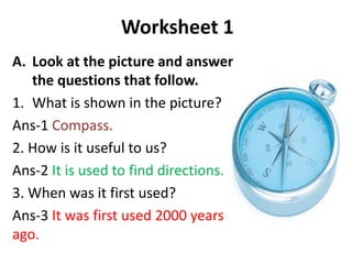
1. What is shown in the picture?
Ans-1 Compass.
2. How is it useful to us?
Ans-2 It is used to find directions.
3. When was it first used?
Ans-3 It was first used 2000 years
ago.
2. • B. With the help of a political map of India,
find out the names of two states that lie in the
following directions of India.
• Directions = States
1. East: (a)West Bengal (b) Jharkhand.
2. West: (a) Rajasthan (b) Gujarat.
3. North: (a) Jammu and Kashmir (b) Himachal
Pradesh.
4. South: (a) Karnataka (b) Kerala.
3. Worksheet 2
• A. Answer these questions in brief.
1. What are globes used for?
Ans-1 Globe can be used to locate continents, countries and
water bodies such as oceans and seas. They are useful in
learning about the true shape of the Earth.
2. What kind of maps are hung on the walls?
Ans-2 Political maps are hung on the walls.
3. What does the Earth look like when it is seen from space?
Ans-3 The Earth looks blue when seen from the space.
4. What is a book of maps called?
Ans-4 A book of maps is called an atlas.
4. Ans: 1. – d, 2. – c, 3. – e, 4. – a, 5. – b
B) Match correctly.
1. drawing of the Earth a) Earth
2. model of the Earth b) continent
3. book of maps c) globe
4. oblate spheroid d) map
5. South America e) atlas
5. • C. Answer these questions in detail.
1. Why do we need to rotate the globe to see all
parts of the Earth?
Ans-1 We need to rotate the globe to see all parts of
the Earth because it is a circular ball and cannot show
the entire Earth at a time.
2. Would there be life on Earth if only one-fourth of it
was covered in water? Give reasons.
Ans-2 If earth was covered with only one-fourth water,
then life on earth would not continue normally as
there will be no sufficient water.
3. What are the uses of a globe?
Ans-3 Globe is used to locate continents, countries and
water bodies such as oceans and seas. They are useful
in learning about the true shape of the Earth.
6. Worksheet 3
A. Answer these questions.
1. Why do you think it is easier to carry maps from one place to
another?
Ans-1 A map can be folded and thus, it is easier to carry them from
one place to another.
2. Why do maps give us more details than a globe?
Ans-2 A map represents a small area, a country, a continent or the
entire world and shows the relative length, depth, width, breadth
or height of a particular location and therefore, gives us more
details than a globe.
3. Maps are extremely important to sailors and navigators. Who
are they?
Ans-3 Maps are extremely important to sailors and navigators
because they show more details about the places on earth along
with directions and sub-directions.
7. B. Find Out.
1. How have Indians contributed to the making
of maps and globes?
Ans-1 Students to search information on the Internet and write
the answer.
2. Write two ways in which maps and globes help
us.
Ans-2
A map can be used to show any place such as a small river
and the area around it.
A map shows directions and sub-directions of the locations.
A globe can be used to locate continents, countries and
water bodies such as oceans and seas.
It is useful in learning about the true shape of the Earth.
8. 1. How have Indians contributed to the
making of maps and globes?
• Indians may be contributing by having people
as experts in geography... & collecting data
about the physio-graphical & land structures
of the areas, climate of areas, countries etc.