1. Indian remote sensing mission
Dept. of Applied Geology Page 1
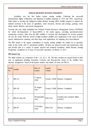
INDIAN REMOTE SENSING MISSIONS
Aryabhata was the first Indian remote sensing satellite. Following the successful
demonstration flights of Bhaskara and Bhaskara-2 satellites launched in 1979 and 1981, respectively,
India began to develop the indigenous Indian Remote Sensing (IRS) satellite program to support the
national economy in the areas of agriculture, water resources, forestry and ecology, geology, water
sheds, marine fisheries and coastal management.
Towards this end, India established the National Natural Resources Management System (NNRMS)
for which the Department of Space (DOS) is the nodal agency, providing operational remote
sensing data services. Data from the IRS satellites is received and disseminated by several countries
all over the world. With the advent of high-resolution satellites new applications in the areas of urban
sprawl, infrastructure planning and other large scale applications for mapping have been initiated.
The IRS system is the largest constellation of remote sensing satellites for civilian use in operation
today in the world, with 11 operational satellites. All these are placed in polar Sun-synchronous orbit
and provide data in a variety of spatial, spectral and temporal resolutions. Indian Remote Sensing
Programme completed its 25 years of successful operations on March 17, 2013.
IRS launch log
The initial versions are composed of the 1 (A, B, C, D). The later versions are named based on their
area of application including OceanSat, CartoSat and ResourceSat. Some of the satellites have
alternate designations based on the launch number and vehicle (P series for PSLV).
Serial
No.
Satellite
Date of
Launch
Launch
Vehicle
Status
1 IRS-1A
17 March
1988
Vostok, USSR Mission Completed
2 IRS-1B
29 August
1991
Vostok, USSR Mission Completed
3 IRS-P1 (also IE)
20 September
1993
PSLV-D1
Crashed, due to launch failure
of PSLV
4 IRS-P2
15 October
1994
PSLV-D2 Mission Completed
2. Indian remote sensing mission
Dept. of Applied Geology Page 2
5 IRS-1C
28 December
1995
Molina, Russia Mission Completed
6 IRS-P3
21 March
1996
PSLV-D3 Mission Completed
7 IRS 1D
29 September
1997
PSLV-C1 Mission Completed
8 IRS-P4 (Oceansat-1) 27 May 1999 PSLV-C2 Mission Completed
9
Technology Experiment
Satellite (TES)
22 October
2001
PSLV-C3 Mission Completed
10 IRS P6 (Resourcesat-1)
17 October
2003
PSLV-C5 In Service
11 IRS P5 (Cartosat 1) 5 May 2005 PSLV-C6 In Service
12 Cartosat 2 (IRS P7)
10 January
2007
PSLV-C7 In Service
13 Cartosat 2A
28 April
2008
PSLV-C9 In Service
14 IMS 1
28 April
2008
PSLV-C9 In Service
15 Oceansat-2
23 September
2009
PSLV-C14 In Service
3. Indian remote sensing mission
Dept. of Applied Geology Page 3
16 Cartosat-2B 12 July 2010 PSLV-C15 In Service
17 Resourcesat-2
20 April
2011
PSLV-C16 In Service
18 Megha-Tropiques
12 October
2011
PSLV-C18 In Service
19 RISAT-1
26 April
2012
PSLV-C19 In Service
20 SARAL 25 Feb 2013 PSLV-C20 In Service
Aryabhatta Satellite
(First Indian Experimental Satellite)
Launch Date: April 19, 1975
Weight: 360 kg
Orbit: 619 x 562 km inclined at 50.70
Launched by: Soviet Intercosmos rocket.
Objectives: The objectives of this project were to
indigenously design and fabricate a space-worthy
satellite system and evaluate its performance in
orbits.
* To evolve the methodology of conducting a series of complex operations on the satellite in its
orbital phase.
* To set up ground-based receiving, transmitting and tracking systems and to establish infrastructure
for the fabrication of spacecraft systems.
The exercise also provided an opportunity to conduct investigations in the area of space sciences.
The satellite carried three experiments, one each in X-Ray Astronomy, Solar Physics and Aeronomy.
4. Indian remote sensing mission
Dept. of Applied Geology Page 4
Bhaskara-I Satellite
(First Indian low orbit Earth Observation Satellite)
Launch Date: June 7, 1979
Weight: 444 Kg
Orbit : 619 x 562 km inclined at 50.70
Launched by : Soviet Intercosmos rocket.
Sensor Systems
Television Cameras operating in visible (0.6 micron)
and near-infrared (0.8 micron); to collect data related to hydrology, forestry and geology.
Satellite microwave radiometer (SAMIR) operating at 19 GHz and 22 GHz for study of
ocean-state, water vapour, liquid water content in the
atmosphere, etc.
Rohini Satellite (RS-1) Series
(Launched by Indian launch vehicle SLV-3)
First RS-1
Launch Date: July 18, 1980
Weight: 35 kg
Orbit: 300 km x 900 km elliptical orbit (97 minutes period)
Launched by: India, SLV-3 rocket
Objectives: The satellite provided data on the fourth stage performance and ranging.
Second RS-1
Launch Date: May 30, 1981
Weight: 35 kg
Launched by: India, SLV-3 (D-1) rocket
Orbit: 300 km x 900 km elliptical orbit (97 minutes period)
Objectives: Carried a Land Mark sensor payload whose solid state camera performed to
5. Indian remote sensing mission
Dept. of Applied Geology Page 5
specifications. The satellite re-entered the earth's atmosphere nine days after launch on account of the
launch vehicle's injecting the satellite into a lower than expected altitude.
Third RS-1
Launch Date: April 17, 1983
Weight: 35 kg
Launched by: India, SLV-3 (D-2) rocket
Orbit: 300 km x 900 km elliptical orbit (97 minutes period)
Objectives: The Smart Sensor Camera was the primary payload on board the satellite. It was
operated for over five months and sent more than 2500 pictures frames in both visible and infrared
bands for identification of landmarks and altitude and orbit refinement. The camera had on-board
processing capability to use the data for classifying ground features like water, vegetation, bare land,
clouds and snow. After completing all its mission goals, RS-D2 was closed down on Sept. 24, 1984.
Stretched Rohini Satellite Series (SROSS)
Lunched by India's Augmented Satellite Launch Vehicle,
ASLV, on May 20, 1992 and May 4, 1994 respectively.
Carried a Retarding Potential Analyser and a Gamma
Ray Burst (GRB) detector. SROSS-C2 has provided
valuable scientific data.
IRS-1A Satellite (First Operational Satellite)
This is first indigenously built sun-synchronous polar
orbiting satellite.
Orbit Details
Launch date : March 17, 1988 (Soviet Launcher VOSTAK used)
Altitude : 904 Kms.
Inclination : 99.049 degrees
Period : 103.19266 minutes
Receptivity : 22 days
Equatorial crossing time : 10.25 AM descending
Weight : 975 Kg.
6. Indian remote sensing mission
Dept. of Applied Geology Page 6
Imaging Sensor Characteristics (LISS-I and LISS-II Cameras)
Parameters LISS-I LISS-II
Focal Length 166.2 324.4
Field-of-view (deg) 9.4 4.7+4.7
Instantaneous field of view(IFOV)
Microrad,
80 40
Detectors (CCDs) 2048 elements
CCD
2048 elements
CCD
Ground Resolution (m) 72.5 36.25
Spectral range (micro meter) 0.45 - 0.86 0.45 - 0.86
Number of Bands 4 4
Swath (Kms.) 148 74x2 ( LISS-A
and LISS-B)
Radiometric Resolution (grey levels) 128 128
Data rate (Mbps) 5.2 10.4x2
Weight (Kgs) 38.5 80.8x2
* LISS -Linear Imaging Self-Scanning Sensor, CCD charge coupled devices.
* LISS-II contains two separate identical sensors LISS-A and LISS-B with a spatial resolution of
36.25 each.
* The 4 bands are:
B1 - 0.42-0.52 (blue)
B2 - 0.52-0.59 (green)
B3 - 0.62-0.68 (red)
B4 - 0.77-0.86 (near IR)
the bands are similar to the LANDSAT 1, 2, 3 and 4 bands.
7. Indian remote sensing mission
Dept. of Applied Geology Page 7
IRS-P1 Satellite (Indigenously Launched (P) Series)
IRS-P series are being launched by indigenously developed polar launch vehicle ( PSLV). Due to
failure in last stage of rocket, satellite and rocket were plunged into sea.
IRS-1B Satellite
This is similar to IRS-1A satellite in all aspects.
Orbit Details
Launch date : August 29, 1991 (Soviet Launcher VOSTAK used)
Altitude : 904 Kms.
Inclination : 99.049 degrees
Period : 103.19266 minutes
Repetivity : 22 days
Equatorial crossing time : 10.25 AM descending
Weight : 975 Kg.
Imaging Sensor Characteristics ( LISS-I and LISS-II Cameras)
Parameters LISS-I LISS-II
Focal Length 166.2 324.4
Field-of-view (deg) 9.4 4.7+4.7
Instantaneous field of
view(IFOV) Microrad,
80 40
Detectors (CCDs) 2048
elements
2048
elements
Ground Resolution (m) 72.5 36.25
Spectral range (micro meter) 0.45 - 0.86 0.45 - 0.86
Number of Bands 4 4
Swath (Kms.) 148 74x2 ( LISS-
A and LISS-
B)
Radiometric Resolution 128 128
8. Indian remote sensing mission
Dept. of Applied Geology Page 8
(grey levels)
Data rate (Mbps) 5.2 10.4x2
Weight (Kgs) 38.5 80.8x2
Power (Watts) 34 34x2
* LISS -Linear Imaging Self-Scanning Sensor, CCD charge coupled devices.
* LISS-II contains two separate sensors LISS-A and LISS-B with a spatial resolution of 36.25 each.
* The 4 bands are:
B1 - 0.42-0.52 (blue)
B2 - 0.52-0.59 (green)
B3 - 0.62-0.68 (red)
B4 - 0.77-0.86 (near IR)
the bands are similar to the LANDSAT 1, 2, 3 and 4 bands.
IRS-P2 Satellite (Indigenously Launched (P) Series)
Orbit Details
Launch date: Oct. 15, 1994
Altitude: 817 Kms.
Receptivity: 24 days
Imaging Sensor Characteristics (LISS-II Camera)
The Satellite is having only LISS-II Camera and its parameters are similar to that IRS-1A/1B with
small modifications in arrangement of CCDs.
Parameters LISS-II
Focal Length 324.4
Field-of-view (deg) 4.7+4.7
Instantaneous field of view(IFOV) Microrad, 40
Ground Resolution (m) 36.74 m (across track)
37/39 m (along track)
Spectral range (micro meter) 0.45 - 0.86
9. Indian remote sensing mission
Dept. of Applied Geology Page 9
Number of Bands 4
Swath (Kms.) 130 km (Liss A + B)
Radiometric Resolution (grey levels) 128
Data rate (Mbps) 10.4x2
Weight (Kgs) 80.8x2
Power (Watts) 34x2
B1 - 0.42-0.52 (blue)
B2 - 0.52-0.59 (green)
B3 - 0.62-0.68 (red)
B4 - 0.77-0.86 (near IR)
the bands are similar to the LANDSAT 1, 2, 3 and 4 bands.
IRS-1C Satellite
This is one of the best satellites having highest spatial resolution of 5.8 m in Panchromatic and 23.5
m in multispectral.
Orbit Details
Launch date : Dec. 28, 1995 (Soviet Launcher Molina used)
Altitude : 817 Kms.
Inclination : 99.049 degrees
Period : 101.35 minutes
Receptivity : 24 days (5 days - revisit)
Equatorial crossing time : 10.30 AM descending
Weight : 1250 Kg.
No. of Sensors : Three; 1) PAN, 2) LISS-III and 3) WiFS
Panchromatic Camera (PAN)
Parameters Specifications (PAN)
Band (microns) 0.50 - 0.75
Resolution (m) 5.8
Effective focal length 980 mm
10. Indian remote sensing mission
Dept. of Applied Geology Page 10
Coding 6 bits (64 grey levels)
Camera SWR 0.2
SNR (at saturation radiance) >64
Data rate (MBPS) 84.903
Swath (km.) 1. Nadir
1. Off-nadir
70
91
Off-nadir viewing (deg) +/-26 for obtaining stereoscopic data and 5 day
revisit
Steering step size (deg) 0.09
The data in the panchromatic region is useful in geological studies for mapping geological
and geomorphological features. Higher spatial resolution will be useful for urban planning studies,
detecting urban fringe growth, updating the urban transportation infrastructure etc. It is having off-
nadir viewing capability and the view angle can be varied between +/- 26 deg. The advantages of off-
nadir viewing are increased receptivity coverage and stereoscopy. Stereoscopic image pair obtainable
by PAN can be used for topographic studies and generation of digital terrain models.
Imaging Sensor Characteristics ( LISS-III Sensor)
Parameters B2 B3 B4 B5
Spectral bands 0.52-0.59(green)
0.62-0.68(red)
0.77-0.86(NIR)
1.55-1.70 (MID)
Resolution (m) 23.5 (for bands
B2,B3,B4)
70.5 (for b5)
CCD devices 6000 elements 2100
Swath (Kms) 141 148
11. Indian remote sensing mission
Dept. of Applied Geology Page 11
Equi focal length (mm) 347.5 301.2
Number of grey levels 128 (7 bits) 128
The bands are similar to the IRS-1A, IRS-1B and IRS-P2 except blue band which is not included in
IRS-1C.
Band 2 is centred around the first peak of the vegetation reflectance curve (refer to reflectance
curves in standard books) and is useful for discrimination of vegetation. This band along with red
and near IR regions forms the core data useful for discrimination of vegetation.
Band 3 is centred around the chlorophyll absorption region of vegetation. Strong correlation exists
between spectral reflectance in this region and chlorophyll content. A reduction in the amount of
chlorophyll can occur when the plant is stressed. This results in less chlorophyll absorption and an
increase in red reflectance. This band along with the near IR band is used widely for deriving
spectral indices like ratio and Normalised Difference Vegetation index (NDVI) which have been
found to be very good indicators of crop vigour and biomass.
Band 4: The high reflectance plateau region of the vegetation reflectance is in this band. Plant
reflectance in this region is highly governed by the internal structure of plant leaves. This band
shows high reflectance for healthy vegetation and is useful for green biomass estimation and crop
vigour.
Band 5: the middle infra-red region from 1.3-2.5 microns is sensitive to leaf water content. It has
been shown that 1.55 - 1.70 is best suited in 0.7-2.5 region for monitoring plant canopy water status.
Major applications of this band include discrimination of crop types, canopy water status, forest type
separation and damage assessment. Crop classification accuracies can be improved by 1-15% when
this band is included with other bands. Also useful snow-cloud discrimination. In geology, it will be
useful for rock type discrimination.
Wide Field Sensor (WiFS)
Parameters Values
Spectral bands (microns) B3 - 0.62-0.68 (red)
B4 - 0.77-0.86 (near IR)
Resolution (m) 188
CCD devices 2048 elements
Swath (Kms) 810 (5 days receptivity)
12. Indian remote sensing mission
Dept. of Applied Geology Page 12
Equivalent focal length
(mm)
56.4
No. of grey levels 128 (7 bits)
SNR >128
This sensor is most useful for vegetation studies. With larger swath (770 Km), high receptivity ( 5
days) and operation in two vegetation specific bands, the sensor provide vegetation index at regional
level, thus helping in assessment of crop condition and drought monitoring.
IRS-P3 Satellite
Orbit Details
Launch date : March 21, 1996 (Indigenous PSLV-D3 rocket is used)
Altitude : 817 km.
Inclination : 99.049 degrees
Period : minutes
Receptivity : days
Equatorial crossing time : 10.30 AM descending
Weight : Kg.
No. of Sensors : Two 1) WiFs, 2) MOS
Wide Field Sensor (WiFS)
Parameters Specifications )
Spectral Bands (microns) B3 0.62 - 0.68
B4 0.77 - 0.86
B5 1.55 - 1.69
Resolution (m) B3 and B4 188x188
B5 188x246
Quantisation bits 7 (128 grey levels
Swath 810 Km.
No. of detectors 2048 x 2 for B3
2048 x 2 for B4
2100 x 2 for B5
S/N ratio >127
13. Indian remote sensing mission
Dept. of Applied Geology Page 13
IRS-P3 WiFS is slightly different from IRS-1C WiFS. In IRS-P3 WiFS, another band (B5) in the
middle infrared region is added for monitoring plant canopy water content.
Modular Optoelectronic Scanner (MOS)
The sensor system is primarily meant for ocean related studies. It operates in narrow spectral bands
in visible, near infrared and short wave infra-red regions (SWIR) of the electromagnetic spectrum
and consists of three optical modules namely MOS-A, MOS-Band MOS-C. Further the sensor
should be able to detect small changes in spectral signature. This is achieved by having 16 bits of
quantisation as against 7 or 8 bits in the sensors used for land applications.
Parameters MOS-A MOS-B MOS-C
Spectral range 0.755 - 0.768 0.408 - 1.010 1.50 - 1.70
No. of Bands 4 13(*) 1
Resolution (m) 1569 x 1395 523 x 523 523 x 644
No. of detectors 140 384 299
Quantisation bits 16 16 16
Swath (kms.) 195 200 192
S/N ratio >100 >100 >100
(*) Each band with 0.001 micrometres band-width.
IRS-1D Satellite (Indigenously launched operational satellite)
Satellite entered in elliptical orbits instead of circular after it was separated from rocket. Due to
this problem, there is change in swath, resolution according to orbit distance from the earth
centre.
Launch date: Sept. 29, 1997 (indigenous PSLV-D4 rocket was used)
Equatorial Crossing time: 10.40 A.M
Altitude: 737 Km (Perigee)/821 Km. (Apogee)
Receptivity: 24 days; (3 days revisit) No. of Sensors: Three; 1) PAN, 2) LISS-III and 3) WiFS
14. Indian remote sensing mission
Dept. of Applied Geology Page 14
Payloads
The payloads are similar to IRS-1C (PAN, LISS-III and WiFS). The satellite is a follow on to IRS-
1C
Resolution: PAN Sensor: 5.2 m (Perigee)/5.8 m (Apogee)
LISS-III sensor : 21.2
m(P)/23.5m(A)
LISS-III MIR : 63.6 m
(P)/ 70.5 m (A)
WiFS sensor : 728 m
(P)/812Km (A)
IRS-P4 (Oceansat-1)
Launch Date: May 26, 1999 by indigenous PSLV rocket
Payloads
OCM (Ocean Colour Monitor) with 8 spectral bands
for the measurements of physical and biological oceanographic parameters.
MSMR (Multi-frequency Scanning Microwave Radiometers)
Operating at 6.6, 10.65, 18.0 and 21 GHz frequencies with H and V polarizations and at
spatial resolution of 150 km, 75 km, 50 km and 50 km respectively.
IRS-P6(ResourceSat)
IRS-P6 (ResourceSat)
Launch Date: Launched on April 20, 2011, PSLV-C16
Payloads
It will be the state-of-art satellite, mainly for agriculture applications and will have 3 band
multispectral LISS-IV cameras with a spatial resolution better than 5.86 m and a swath of
around 25 km with across track steer ability for selected area monitoring. An improved
version LISS-III with 4 bands (red, green, near IR and SWIR); all at 23 m resolution and 140
km swath will provide the much essential continuity to LISS-III.
The sensors on board the satellite will provide data which is useful for vegetation related
applications and will allow multiple crop discrimination and species level discrimination.
Together with an advanced Wide Field Sensor (WiFS), with 80 m resolution and 1400 km
swath, the payloads will greatly aid crop/vegetation and integrated land and water resources.
15. Indian remote sensing mission
Dept. of Applied Geology Page 15
IRS-P5 (CARTOSAT -1)
Launch Date: May 5, 2005 by indigenous PSLV
rocket
Payloads
It has carried two state-of-the-art
Panchromatic (PAN) cameras with 2.5 m
resolution with fore-aft stereo capability. The
swath covered by these high resolution PAN
cameras is 30 km. This mission will cater the needs of cartographers and terrain modelling
applications. The satellite will provide cadastral level information up to 1:5000 scales and
will be useful for making 2-5 m contour maps. The Cartosat-1 also carried a solid state
recorder with a capacity of 120 Gigz Bits to store the images taken by its cameras.
IRS-P7 (CARTOSAT -2)
Launch Date : Jan 10, 2007 by indigenous PSLV-C7 rocket
Payloads
It carried a single Panchromatic (PAN) camera with 1 m
resolution capable of providing scene specific spot imageries
for cartographic applications at cadastral level. The swath
covered by the high resolution PAN camera is 9.6 km. This
mission will cater the needs of cartographers and terrain
16. Indian remote sensing mission
Dept. of Applied Geology Page 16
modelling applications. The satellite will have high agility with capability to steer along and
across the track up to 45 degrees. It was placed in a sun-synchronous polar orbit at an altitude
of 635 km. It has a revisit period of 4 days, which can be improved to one day with suitable
orbit maneuvers.
IRS-P6 (ResourceSat-2)
Launch Date : Launched on April 20, 2011 PSLV-C16
Payloads
It will be the state-of-art satellite, mainly for agriculture applications and will have 3 band
multispectral LISS-IV cameras with a spatial resolution better than 5.86 m and a swath of around 70
km (improved 25 km to 70 km) with across track steer ability for selected area monitoring. An
improved version LISS-III with 4 bands (red, green, near IR and SWIR); all at 23 m resolution and
140 km swath will provide the much essential continuity to LISS-III. Radiometric resolution is
improved 7 bits to 10 bits for LISS-III and 10 bits 12 bits for LISS-IV.
The sensors on board the satellite will provide data which is useful for vegetation related
applications and will allow multiple crop discrimination and species level discrimination.
Together with an advanced Wide Field Sensor (WiFS), with 80 m resolution and 1400 km
swath, the payloads will greatly aid crop/vegetation and integrated land and water resources
related applications.
IRS-1A/IB Digital Product Information
IRS-1A/1B data contains four files which are being supplied through CD-ROM or Tapes (DAT and
Exabyte).
17. Indian remote sensing mission
Dept. of Applied Geology Page 17
The supplied media contains 5 files, which are
1) Volume directory file,
2) Leader file
3) Imagery file
4) Trailer file
5) Null volume file
Data can be extracted from Tape to disk through UNIX dd command with proper ibs and obs (block
size) options or through commercial softwares.
In case of raw data (not geo-coded) of IRS-1A/1B, the file sizes are
1) volume dir file 1800 bytes
2) Leader file 13312 bytes
3) Imagery file 25202520 bytes
4) Trailer file 1800 bytes
5)Null volume 360 bytes.
In Imagery file, there is header with 2520 bytes. The imagery file is in BIL format.
No. Lines = 2500 No. Pixels= 2520
IRS-1C/ID (LISS-III) Digital Product Information (FULL SCENE)
This product also contains 5 files with the sizes
1) Volume dir file 1800 bytes
2) Leader file 97920 bytes
3) Imagery file 155624220
4) Trailer file 1800
5) Null file 360 bytes
In Imagery File, there is a header of size 540 bytes. No. of Band : 4 (BIL format)
No. of Lines: 6004
No. of Pixels: 6480
IRS-1C/1D (LISS-III) Digital Product (quarter scene)
This product contains 5 files with the size
1) Volume dir file 1800 bytes
2) Leader file 91800 bytes
3) Imagery file 37430460
4) Trailer file 1800
5) Null file 360 bytes
Header size : 540 pixels
Number of Lines : 3058
Number of Pixels : 3060
18. Indian remote sensing mission
Dept. of Applied Geology Page 18
IRS-1C/1D PAN Geocoded Product of small area
This product contains 5 files
1800 Bytes VOLUME.PAN
73440 Bytes LEADER.PAN
8070300 Bytes IMAGERY.PAN
720 Byte TRAILER.PAN
360 Bytes NULL.PAN
Header size : 540 Pixels
The number of lines : 2802
The number of pixels : 2880
Please note that 31 pixels are prefixed and 114 pixels are suffixed in 2880 pixels
Here is the program in 'C' for the separation of bands from BIL format band_sep.c
For decoding Leader file of IRS-1C/1D, you please visit NRSA site and download programme.
Future IRS launches
Following are the remote sensing satellites planned by ISRO to be launched next strengthening the
fleet of IRS satellites and widening their applications:
RESOURCESAT-3: A follow on to Resourcesat-2, it will carry more advanced LISS-III-WS
(Wide Swath) Sensor having similar swath and revisit capability as Advanced Wide Field Sensor
(AWiFS), thus overcoming any spatial resolution limitation of AWiFS. Satellite would also
carry Atmospheric Correction Sensor (ACS) for quantitative interpretation and geophysical
parameter retrieval. It slated to be launched during 2021
CARTOSAT-3: A continuation of Cartosat series, it will have a resolution 30 cm and 6 km
swath suitable for cadastre and infrastructure mapping and analysis. It would also enhance
disaster monitoring and damage assessment. It is slated to be launched during 2018.
OCEANSAT-3: Oceasat-3 would carry Thermal IR Sensor, 12 channel Ocean Color Monitor,
Scatterometer and Passive Microwave Radiometer. IR Sensor and Ocean Color Monitor would
be used in the analysis for operational Potential Fishing Zones. Satellite is mainly for Ocean
biology and sea state applications. It is slated to the launched aboard PSLV in 2012-13.
IRS data applications
Data from Indian Remote Sensing satellites are used for various applications of resources survey and
management under the National Natural Resources Management System (NNRMS). Following is the
list of those applications:
19. Indian remote sensing mission
Dept. of Applied Geology Page 19
Space Based Inputs for Decentralized Planning (SIS-DP)
National Urban Information System (NUIS)
ISRO Disaster Management Support Programme (ISRO-DMSP)
Biodiversity Characterizations at landscape level- http://bis.iirs.gov.in
Preharvest crop area and production estimation of major crops.
Drought monitoring and assessment based on vegetation condition.
Flood risk zone mapping and flood damage assessment.
Hydro-geomorphological maps for locating underground water resources for drilling well.
Irrigation command area status monitoring
Snow-melt run-off estimates for planning water use in downstream projects
Land use and land cover mapping
Urban planning
Forest survey
Wetland mapping
Environmental impact analysis
Mineral Prospecting
Coastal studies
Integrated Mission for Sustainable Development (initiated in 1992) for generating locale-specific
prescriptions for integrated land and water resources development in 174 districts.
CONCLUSION
Comparing to NASA, ISRO also release many of the remote sensing satellites with highest
successful rate. But India need support from the other countries. Now a days India is launching many
Satellites due to support of Government .
As we are citizens of India we have to know how India is developing in the global level and in space
research.
For geology these satellites are Important to get information of remote places of earth. We have to
study the sensors used by ISRO to get information about the earth.
REFERENCES:
www.isro.gov.in
www.wikipedia.org/wiki/indianremotesensingmissions&client
www.csre.iitb.ac.in/isro