3. 3 WWW.AAPG.ORG MARCH 2010
EXPLORER
AAPG
TABLEofCONTENTS
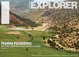
ON THE COVER:
The Shaikan1-B discovery well, located
in Iraq’s Kurdistan province near the city
of Dohuk, about 85 kilometers northwest
of Erbil. The well, drilled by Gulf Keystone
Petroleum in spring 2009, reached TD
at 2,950 meters measured depth and
encountered nine hydrocarbon-bearing
formations within Cretaceous, Jurassic
and Triassic deposits. The Shaikan
structure is an east-west anticline at
the northwestern part of the Zagros/
Taurus Foldbelt. Photo courtesy of AAPG
member Chris Garrett.
The AAPG EXPLORER (ISSN 0195-2986) is published monthly for members. Published at AAPG headquarters, 1444 S. Boulder Ave., P.O. Box 979, Tulsa, Okla. 74101, (918) 584-2555.
e-mail address: postmaster@aapg.org. Periodicals postage paid at Tulsa, Okla., and at additional mailing offices. Printed in the U.S.A. Note to members: $6 of annual dues pays for one
year’s subscription to the EXPLORER. Airmail service for members: $55. Subscription rates for non-members: $75 for 12 issues; add $72 for airmail service. Advertising rates: Contact
Brenda Merideth, AAPG headquarters. Subscriptions: Contact Veta McCoy, AAPG headquarters. Unsolicited manuscripts, photographs and videos must be accompanied by a stamped,
self-addressed envelope to ensure return. The American Association of Petroleum Geologists (AAPG) does not endorse or recommend any products or services that may be cited, used or
discussed in AAPG publications or in presentations at events associated with AAPG. Copyright 2009 by the American Association of Petroleum Geologists. All rights reserved.
POSTMASTER: Please send address changes to AAPG EXPLORER, P.O. Box 979, Tulsa, Okla. 74101. Canada Publication Agreement Number 40063731 Return undeliverable Canadian
address to: Station A, P.O. Box 54 • Windsor, ON N9A 6J5 • E-mail: returnsIL@imex.pb.com
REGULARDEPARTMENTS
6 Earthquakes, volcanoes, landslides,
sinkholes. Dangerous stuff, geology
– but geologic experts are helping
societies to study, explain and deal
with geohazards.
12 Experts have spoken about its oil
potential for decades. Finally, Iraq
is primed to fulfill its promise – and
its opportunities aren’t just for the
super-big players, either.
18 The eye of the beholder: Seismic
data interpretations are notoriously
varied – and sometimes just plain
wrong. But now a team of Scottish
geoscientists (pictured below) is
shedding some light on what often
goes wrong – and why.
24 At last, a reason to thank your
kids for playing video games:
PlayStation 3 technology is
elevating seismic imaging to a
whole new level of refinement.
30 Chat room redux: New technology
and research efforts are making it
possible for seismic data to “talk”
to seismic data. And the stories
they can tell …
38 Not all shales are created equal;
the Illinois Basin’s New Albany
shale, for example, has yet to
be mistaken for the Barnett. But
geoscientists, armed with new
technology, are about to find
out why.
Geophysical Corner..............................34
Washington Watch.................................36
Spotlight On …......................................44
Professional News Briefs.......................45
In Memory.............................................45
Regions and Sections...........................46
Foundation Update................................48
wwwUpdate...........................................49
Membership and Certification...............51
Readers’ Forum.....................................53
Classified Ads.......................................54
Director’s Corner...................................55
DEG Column..........................................55
STAFF
Communications Director
Larry Nation
e-mail: lnation@aapg.org
Managing Editor
Vern Stefanic
e-mail: vstefan@aapg.org
Communications Project Specialist
Susie Moore
e-mail: smoore@aapg.org
Correspondents
David Brown
Louise S. Durham
Graphics/Production
Matt Randolph
e-mail: mrandolph@aapg.org
Advertising Coordinator
Brenda Merideth
P.O. Box 979
Tulsa, Okla. 74101
telephone: (918) 560-2647
(U.S. and Canada only:
1-800-288-7636)
(Note: The above number is
for advertising purposes only.)
fax: (918) 560-2636
e-mail: bmer@aapg.org
AAPG Headquarters:
1-800-364-2274 (U.S. & Canada only),
others 1-918-584-2555
Vol.31,No.3Vol. 31, No. 3
March 2010
The EnergyRatio Limit
G
rowing up during the Lower Diluvian
epoch, when my father got us out of
bed to watch Sputnik blink across
the sky as the world’s first satellite and
we began to learn new math instead
of arithmetic, gasoline for the family
dinosaur cost about $0.33/gallon. Since
then, inflation has raised the price of U.S.
postage stamps from $0.04 to $0.44, the
model airplanes I bought as a youth for
$1.06 now cost about $15, and the cost
of groceries has increased significantly.
By these subjective measurements,
in the United States that $0.33 gallon
of gasoline should now cost well over
$3 just to account for inflation, with
an additional price bump to cover the
fact that oil and gas have become
harder to find and produce. Believe it
or not, gasoline and other hydrocarbon
products are better bargains now than
they were 50 years ago, and given the
improved fuel economy of modern cars
we probably spend a lower percentage
of our income on gasoline than we did
back then.
Even so, many complain about the
price of hydrocarbons, unwilling to allow
for the fact that the oil and gas industry is
a business that depends on an economic
return for the effort. We don’t explore for
oil and gas just for the sake of proving
theories about the presence/absence of
an oil pool, even though that is the fun,
scientific part of the job. And since an
economic return is necessary, known
fields containing millions of barrels of oil
remain untapped because it would cost
more to extract and transport the oil than
could be recovered by its sale. Such
dollar limits change with product prices,
thus many such fields can and will be
produced when prices for oil and gas
increase.
However, there is a different and less
flexible energy-budget limit involved in
the production of fossil fuels. As long as
oil is being recovered for use primarily as
an energy source, no one can afford to
expend the amount of energy found in a
barrel of oil in order to drill for, pump out,
and transport less than a barrel of oil.
Jeremy Boak is the new chair of the
AAPG Energy Minerals Division Oil Shale
Commodity Committee, and professor at
the Colorado School of Mines. According
to Boak, the ratio between 1) the energy
expended in obtaining oil, and 2) the
energy recovered by the process* was
probably 1:100 or better for new wells
in the era of easy oil, but the ratio has
fallen to 1:20 or even 1:10 as that oil has
been depleted. The ratio is even less
for mature fields that require advanced
oil recovery techniques, where Boak
suggests that the ratio is below 1:10.
So far, efficiency gains through better
science and technology have kept the
ratio from declining to the point where, as
with corn-based ethanol, it’s debatable
whether a net energy benefit exists.
Ultimately, even when over half the
oil remains in the ground, industry
makes the decision to abandon a
field when it takes more money and
energy to recover the oil than can be
extracted from the recovered oil. And
with many conventional fields reaching
their production capacity limits we are
again looking at extracting fossil energy
from the immature kerogen in oil shale
formations, where Boak says the energy-
in/energy-out ratio is only between 1:3½
and 1:5. The renewed interest in this
and other unconventional resources is
an indirect indication both of industry’s
internal forecasts for energy demands
and of how close to the bone we are
getting.
Rising oil prices will only go so far
in promoting recovery of the world’s
fossil energy resources. The laws of
physics limit how much oil and gas
can be recovered from small, deep,
or remote fields as long as we don’t
intend to put more energy into the
ground than we extract from it. Once
we develop reliable and inexpensive
alternative energy sources we may use
hydrocarbons primarily for purposes
such as chemical feedstock instead
of merely burning them, whereupon
they could conceivably become more
valuable than the energy they contain. In
the meantime, our job as geologists is to
use the best available geoscience when
picking drilling locations and determining
completion techniques. Every day, AAPG
members are advancing the science and
technology that help keep the energy
ratio favorable.
* Described as the “EROI,” the energy
return on investment, by Cleveland, C.J.,
2005, “Net energy from the extraction of
oil and gas in the United States,” Energy,
v. 30, p. 769-782.
By JOHN C. LORENZ
PRESIDENT’SCOLUMN
LORENZ
Our job as geologists is to use
the best available geoscience
when picking drilling locations and
determining completion techniques.
SEISMIC
22222222222222222222222222222222222222222222222222222222222222222222222000000000000000000000000000000000000000000000000000000000000000000000000001111111111111111111111000000000000000000000000000000000000000000000000000000000000000000000000000000000000
6. EXPLORER
AAPG
6 MARCH 2010 WWW.AAPG.ORG
Haiti indicators studied
GeohazardsLurkin Familiar Places
A
n earthquake in Haiti brings
widespread death and destruction.
A volcano erupts in the Philippines
and 50,000 evacuate. A massive
landslide destroys homes in San Diego.
Dangerous stuff, geology.
In the United States, geological
hazards are monitored and studied
by the U.S. Geological Survey. The
USGS Geologic Hazards Team has its
headquarters in Golden, Colo.
It works in earthquake-hazard,
landslide-hazard and geomagnetism
programs and partners in the Global
Seismographic Network (GSN).
Additional earthquake research and
monitoring is conducted in USGS
offices in Menlo Park, Calif., Seattle and
Anchorage, Alaska.
The GSN provides worldwide
monitoring of the Earth, with more than
150 seismic stations distributed globally.
“In the case of Haiti, we have a sub-
network of nine stations in the Caribbean
(at the time of the Jan. 17 earthquake).
There is literally not a seismometer
in Haiti, so all the activity has to be
monitored remotely,” said AAPG member
David Applegate, USGS senior science
adviser for earthquakes and geologic
hazards in Reston, Va., and formerly
was director of the American Geological
Institute’s Government Affairs Program,
working closely with AAPG on policy
initiatives.
Monitoring earthquakes and gathering
data make up a significant part of the
USGS hazards mission, essential for
issuing emergency notification.
“We try to get the fastest information
and the richest information out to the
emergency responders as quickly as
possible,” Applegate noted.
“For the Haiti earthquake, we issued
the magnitude 7.0 estimate within 20
minutes,” he added. “We also were able
to say at least two million people were
exposed to violent shaking.”
Haiti: In the Field
Geologists also are early responders
following a destructive earthquake, but in
a different sense.
Paul Mann, another AAPG member, is
a senior research scientist for the Institute
for Geophysics at the University of Texas
at Austin. He and a fellow scientist
traveled to Haiti after the January
earthquake to conduct fieldwork.
“He and I are both involved in rapid
response. I’ve just spent five days down
there measuring the fault,” Mann said.
“It was sort of like being in World
War II. Everything was wrecked. All the
buildings were blocks of concrete,”
he recalled.
Also, he said, people afraid to live
indoors were staying outside everywhere
– usually under makeshift tents made of
bedspreads stretched across string.
Mike Jacobs, speaking as president
of AAPG’s Division of Environmental
Geosciences, shared the concern.
“We as geologists, of course, are
aware of the geological risks of living
and working in certain regions and can
make educated decisions on whether or
not we choose to accept those risks,” he
said. “The tragedy with Haiti is that it is
populated by some of the poorest people
on this earth – and even if they were
aware of the risk, they most likely had no
choice on whether or not to accept it.
“Many paid the price with death and
suffering,” Jacobs said, “and my prayers
and thoughts go out to them.
According to Mann, scientists need to
react quickly to study indicators of recent
earthquake activity, “ephemeral effects
that are important but not permanent.
“It’s a very good example of teamwork
in trying to get down there while these
indicators still exist,” he said. “Some of
those will disappear with the first heavy
rainstorm.”
Mann was able to travel to the
epicenter fault area, detailing the near-
site effects and discovering the ground
had not ruptured from the quake.
“That’s an important piece of
information to have. It shows what
happened to that fault during the
earthquake,” he said.
The Haiti quake involved an
80-kilometer section of the 600-kilometer
Enriquillo-Plantain Garden Fault, which
stretches from Jamaica to the Dominican
Republic, Mann said.
Movement of the adjacent plates
builds up fault stress very slowly, but
inexorably. Earlier measurement and
calculation had shown about two meters
of stress built up on the fault, Mann
noted.
“If you release two meters of stress on
this fault you would get a 7.2 magnitude
earthquake, so it was just a little smaller
than we thought,” he said.
Mann was frequently interviewed
By DAVID BROWN, EXPLORER Correspondent
The U.S. Geological Survey monitors
earthquakes, volcanoes, landslides
and geomagnetism. Other agencies
track hurricanes, tsunamis, floods, even
icebergs.
Which has the greatest day-to-day
effect on the oil and gas industry?
Most likely, geomagnetism.
It’s not hard to think of big impacts
from fluctuations in the Earth’s magnetic
field – causing voltage surges in
power lines that can lead to blackouts,
interrupting radio transmissions,
degrading the effectiveness of GPS,
damaging satellite electronics and so on.
Geomagnetism also affects national
security operations, said Jeffrey Love,
adviser for geomagnetic research for the
USGS in Golden, Colo.
During magnetic storms, navigational
systems can be affected and
astronauts and airplane passengers
can be subjected to enhanced levels of
radiation. Not surprisingly, the U.S. Air
Force is a BIG customer of the National
Geomagnetism Program.
And “during large magnetic storms,
it’s not unusual for expensive satellites to
be lost or damaged,” Love said.
Oil and gas companies also draw on
the USGS geomagnetism data.
“They oftentimes engage in
directional drilling, with a small
magnetometer in the instrument package
that’s lowered into the hole,” he noted.
At high latitudes, a compass reading
can vary as much as 10 to 20 degrees
during a large geomagnetic event, Love
said, so correcting for geomagnetism is
more than a minor concern.
Pipeline operators also keep their
eyes on the data because magnetic
activity worsens pipeline corrosion.
“What the pipeline industry does
is put a current into their pipeline that
offsets the current induced by the natural
magnetic field variations,” he said.
The USGS operates magnetic
observatories to measure
geomagnetism. Customers can get
direct information feeds or monitor
various program resources.
Data also is available through the
International Real-Time Magnetic
Observatory Network, known as the
INTERMAGNET program, currently
chaired by Love.
At the USGS, “we’re now working
with the industry up in Prudhoe (Alaska).
We’re installing a magnetic observatory
to assist with directional drilling,” he
said.
– DAVID BROWN
A day-to-day effect
Geomagnetic Activity AlsoaRisk
Evidence of geohazards in South Africa: Left, a rock slide on Tafelberg road (Table Mountain), right, another rock slide episode within siliciclastic Cape Supergroup of South Africa, near Cape Town.
APPLEGATE
“We try to get the fastest
information and the richest
information out to the emergency
responders as quickly as possible.”
See Geohazards, page 8
Photos courtesy of Vaughn Thompson
8. EXPLORER
AAPG
8 MARCH 2010 WWW.AAPG.ORG
by national media after the quake
as one of a small group of scientists
who’d produced studies warning of the
possibility of a major earthquake in Haiti.
“‘Predicted’ would be too strong a
word, because they didn’t say anything
about when that earthquake might
happen,” Mann said.
“The real fear now,” he added, “is that
the movement of this 80-kilometer section
has increased the stress on the adjacent
parts of the fault.”
‘A Very Young Science’
Although earthquake science has
made impressive advances, it has not
reached the point of predicting the time
of an event, or even narrowing down the
possibility into a short timeframe.
“That has proven elusive,” Applegate
conceded.
“Instead, what we focus on are
medium- and long-range forecasts,” he
said.
For the USGS, that means an
assessment of a quake’s likely intensity
and probability in a 30-year to
50-year period.
As an example, Applegate cited a
2008 joint forecast by the USGS and
other agencies that predicted a 99
percent likelihood in the following 30
years for a quake of 6.7 magnitude or
greater in California, with the two most
likely candiates for a major earthquake
being the Hayward Fault in the San
Francisco Bay area or the southern
section of the San Andreas Fault.
“It’s still a very young science.
We seem to know more from every
earthquake, but we still have a long way
to go before we have a good handle on
the predictability,” said Carol Prentice, a
paleoseismologist for the USGS Western
Earthquake Hazards Team in Menlo Park.
“What you don’t know is if an
earthquake is going to happen now, or
will the strain accumulate for another 100
years and it will be a bigger earthquake,”
she added.
Earthquake researchers focus on
Late Holocene geology and events,
conducting fieldwork for measurement
of current and past activity. A major
technique “is to cut trenches across
faults to see where earthquakes have
occurred,” Prentice said.
They also conduct surface studies
of fault areas, aided by remote sensing
technology that can image through
vegetation.
“The most exciting thing these days is
LIDAR,” she said. “It’s a remote sensing
device that actually looks through trees.”
While some areas of the world are
well-studied, Haiti is in an area not nearly
as well understood seismically, Prentice
noted.
“The studies that need to be done just
haven’t been done,” she said. “We never
got the funding to do it.”
Long-Lasting Consequences
The USGS also conducts a Volcano
Hazards Program, with a network of five
major volcano observatories and other
resources, and with additional research
conducted at the Menlo Park Science
Center.
“Unlike earthquakes, volcanoes
have proven to be fairly predictable.
We’re in the process of developing a
national volcano early warning system,”
Applegate said.
Beyond the immediate effects of
a volcano eruption, the event can
have longer-lasting and far-reaching
consequences. For instance, “there have
been several cases where aircraft have
flown into a volcano ash cloud and lost
engines, sometimes all four engines,” he
noted.
But earthquakes remain
unpredictable, and right now scientists
are studying the geological aftermath
of the Haiti quake. Researchers often
say the most likely place to expect
earthquakes is where earthquakes have
struck before.
“This quake is not the worst
earthquake that could have happened.
That’s what is so stunning. This
earthquake broke to the west, so the bulk
of the seismic energy was directed away
from the city,” Applegate said.
“The fault has not done all that it’s
going to do. As rebuilding takes place,
we can say with high certainty that
structures need to be able to withstand
at least the amount of shaking we saw in
the last event,” he added.
Earthquake risk is measured not only
by the likelihood of an event, but also
by the amount of destruction that might
result.
“An important point to make is that
there are a lot of major cities located near
active geologic faults. And as population
grows in areas of activity, the risk grows,”
Prentice observed.
That’s one reason she thinks
earthquake forecasts, even with limited
certainty, are a valuable tool.
“If you hear there’s a 68 percent
chance of rain,” she said, “you might
bring an umbrella.”
EXPLORER
PRENTICE
“There are a lot of major cities
located near active geologic faults.
And as population grows in areas
of activity, the risk grows.”
Geohazards
from page 6
12. EXPLORER
AAPG
12 MARCH 2010 WWW.AAPG.ORG
T
here are a number of folks who
appear to suffer from modern-day
Chicken Little syndrome – except
rather than running about proclaiming the
sky is falling, they’re all aflutter that the
world is running out of oil.
Perhaps so, but the global petroleum
scene makes this prediction a hard sell to
many.
New technology continues to provide
access to previously inaccessible
deposits, and big new finds aren’t
unusual. Look, for instance, at McMoRan
Exploration’s recent five-mile-deep
discovery in the Gulf of Mexico that has
the potential to open up a whole new play
in the shallow water Gulf.
Then take a gander at the sizeable
proven oil reserves – particularly in the
Middle East, where Saudi Arabia reigns as
the undisputed kingpin harboring about
260 billion barrels of black gold.
Iraq reportedly occupies second place
on the giant reserves list, boasting 115
billion barrels, followed by Iran with 90
billion.
Iraq’s petroleum deposits are
concentrated principally in the northern
and southern regions of the country.
The bulk of oil production and exports
originate in the southern province of
Basra, while significant amounts come
from fields in the northern region near the
city of Kirkuk, according to AAPG member
Louis Christian, a Dallas-based Middle
East exploration consultant.
Iraq essentially is one big oil pool
waiting to be produced following years of
turmoil in the country.
Christian emphasized that from a
geological point of view, Iraq is far less
intensely explored than Saudi Arabia, and
perhaps Iran as well.
“Tens of kilometers or even 100
kilometers between wells and seismic
lines in parts of Iraq west of the Euphrates
River leave open, inadequately explored
regions,” he said, “where Iraqi gravity and
magnetic modeling suggests undrilled
structural trends and horst blocks with
the potential for Mesozoic and Paleozoic
closures, carbonate shelf edges and reef
trends analogous in age and dimensions
to the Paleozoic basins of West Texas.”
Christian said Paleozoic prospectivity
in Iraq depends largely on lower Silurian
source rocks, where thermal maturity
runs the gamut from cool and immature
to mature – and on to sometimes
over-mature, depending on current
temperatures as well as past burial and
re-uplift histories.
Just Getting Started
Look for the exploration action to rev
up soon given the many companies just
waiting for the chance to explore this oil-
rich country, now that the political scene is
beginning to stabilize somewhat and the
government is putting out a welcome mat
of sorts.
In fact, Halliburton CEO Dave Lesar is on
record as saying he expects new drilling in
Iraq to spark a “land rush,” provided there’s
a peaceful Iraqi election in March as well
as passage of an oil law by the nation’s
Parliament. Such a law would lead to a more
inviting climate for foreign investment.
Considerable bickering and
disagreements have stalled passage
of a pending oil law, delaying an influx
of the industry players standing on the
sidelines eager to tap into the vast reserves.
In the northern part of Iraq, Kurdistan
stepped away from the fray early on and
implemented its own law.
Attempts by the oil and service
companies to secure contracts in the
country may be a frustrating exercise, but
the real challenges will come later.
Whether wanting to explore and develop
or to provide services to existing fields,
nothing will be easy in this region where
years of warfare and lack of expertise both
have taken their toll.
For instance, oilfield infrastructure has
Legalities, realities are high hurdles
IraqPotentialFaces aLotof ‘Ifs’By LOUISE S. DURHAM, EXPLORER Correspondent
Oil seeping from the Pila Spi formation on the north limb of the Shaikan Anticline, Iraq.
See Iraq, page 14
Photos courtesy of Chris Garrett
14. EXPLORER
AAPG
14 MARCH 2010 WWW.AAPG.ORG
suffered dramatically from neglect and
purposeful destruction, and many reservoirs
reportedly have suffered damage due to
lack of production know-how. Also, there’s
no guarantee that oilfield sabotage events
are a thing of the past in this fragile country
still plagued by terrorism, corruption and
other problems.
Developing Story
Thus far, the Iraqi government has
conducted two bid rounds that included
some of its largest fields.
In the first round, BP and China National
Petroleum Corp. received the only contract,
which entails redeveloping the enormous
17-billion barrel Rumaila field in southern
Iraq on the Kuwait border. The companies
reportedly intend to spend $15 billion to jack
up the production to 2.85 million bopd from
the current one million bopd, catapulting
Rumaila to second place in output
worldwide behind the giant Ghawar Field in
Saudi Arabia.
Other giant fields in southern Iraq
already are designated to see some action.
These include West Qurna, which is said
to hold 21 billion barrels.
In a joint venture, ExxonMobil and Royal
Dutch Shell were awarded a contract to
develop the nine billion barrel West Qurna-1
field. Statoil and Lukoil are reported to have
partnered to ink a deal to develop the 12-
plus billion-barrel West Qurna-2.
Not far away to the east, Shell and
Petronas latched on to a contract to develop
the 13 billion-barrel Majnoon field, where
development has been hindered by its
location on the Iranian border. Majnoon
reportedly means “crazy” in Arabic, which
was considered to be an appropriate
moniker for a field holding such massive
reserves in a relatively small geographic area.
Oil industry interest in southern Iraq
clearly is intense, yet the productive
Kurdistan region in the north has its share
of the action, including the prolific Kirkuk
field, which was originally discovered in
1927. The field may hold nine billion barrels
of remaining reserves, but it has suffered
considerable damage.
For example, waterflood projects had
broken down in the past, and the field
workers were re-injecting processed
crude and residual oil back into the sands
because there was no other place for it,
according to AAPG member Harry “Bud”
Holzman, geological consultant.
Independents’ Day
Opportunities in Iraq aren’t exclusively for
the super-big players.
Look, for instance, at Gulf Keystone
Petroleum Ltd., which is a Bermuda-
registered independent oil and gas
exploration company listed in London
that focuses on exploration in the highly
prospective and productive Kurdistan
region in northern Iraq.
Gulf Keystone drilled the Shaikan1-B
discovery well in 2009 in the Shaikan block
near the city of Dohuk, about 85 kilometers
northwest of Erbil. The block covers an area
of 283 square kilometers.
The Shaikan structure in the Kurdistan
province is an east-west anticline at the
northwestern part of the Zagros/Taurus
Foldbelt, according to AAPG member Joe
Studlick, COO at Dynamic Global Advisors
in Houston and a 2009 Robert H. Dott
Award-winning co-author. The structure is
on trend with several major discoveries,
including Miran West, Kirkuk, Taq Taq and
Tawke.
“The early Paleozoic history of this
province was dominated by clastic
deposition,” Studlick said. “Silurian shale
was deposited during this time and is a key
source rock in the region.
“Carbonates dominate the reservoirs
of the Mesozoic stable platform of the
Zagros Foldbelt,” he said, adding that
“multiple potential source rock intervals –
Triassic, Middle and Upper Jurassic, Lower
and Middle Cretaceous – occur in this
sequence.”
The Shaikan1-B well reached TD
at 2,950 meters measured depth and
encountered nine hydrocarbon-bearing
formations within Cretaceous, Jurassic and
Triassic deposits. Drilling was halted several
hundred meters above the planned TD
because of an influx of high-pressure gas
Parasitic folds in the Pila Spi on the gently dipping south limb of the Shaikan Anticline.
Irag
from page 12
See Kurdistan, page 20
18. EXPLORER
AAPG
18 MARCH 2010 WWW.AAPG.ORG
Euan Macrae’s seismic interpretation exercise will be offered at the Midland Valley booth (925) in the exhibits
hall during the upcoming AAPG Annual Convention and Exhibition in New Orleans. The Virtual Seismic Atlas
also has a booth, 1558. Clare Bond’s paper, “When There Isn’t a Right Answer – Dealing With the Uncertainty
of Seismic Interpretation to Maximize Success,” will be presented at 2:20 p.m. on Monday, April 12.
Its beauty lies in the eye of the beholder
InterpretationSkills Hone With Experience
I
t’s a small miracle that someone can look
at a set of seismic lines, then produce an
interpretation related to real-world geology.
And it’s no surprise at all that some of
those interpretations are wildly wrong.
At AAPG’s upcoming Annual Convention
and Exhibition in New Orleans, geoscientist
Clare Bond will discuss the interpretation
of seismic data, what builds confidence
for interpreters – and what one technique
produces the best results.
Bond, structural geologist for Midland
Valley Exploration Ltd. in Glasgow, Scotland,
will present “When There Isn’t a Right Answer
– Dealing With the Uncertainty of Seismic
Interpretation to Maximize Success.”
She and her colleagues have studied how
geoscientists approach seismic information
to develop geological models.
In particular, they were interested in the
failed or inaccurate interpretation with a poor
match to naturally evolved geology.
“You can kind of look at it with an expert
eye and say, ‘That doesn’t work.’ We were
interested in why people create cross-
sections that don’t make any sense,” she
said.
Geoscientists aren’t alone in struggling
with incomplete information or flailing about
because of unknown variables.
Bond cited a landmark paper by Nobel
Prize laureate Daniel Kahneman and
his frequent collaborator Amos Tversky,
“Judgment Under Uncertainty: Heuristics
and Biases,” published in the journal Science
in 1974.
“It basically looked at how awful human
beings are in making decisions when there is
uncertainty,” she noted, “or at least risking.”
The Bearing of Bias
As part of this project, Bond gave
a synthetic seismic section to various
participants and asked for their
interpretations. Participants in her studies
have been drawn about 50-50 from industry
and academia, and have ranged from
university undergraduates to professionals
with more than 15 years of experience, she
said.
Out of 412 interpretations:
u Only 21 percent of the participants
identified the correct tectonic setting of the
original model.
u Only 23 percent were able to highlight
the three main faults in the seismic image.
u Only 10 percent of the interpretations
showed the correct inversion model for the
section.
That experiment quantified the range of
conceptual uncertainty for the seismic set
and helped identify factors that influence
how knowledge and concepts are applied to
seismic interpretation.
By examining the results, Bond and her
colleagues were able to classify distinct
interpretational techniques, to determine
what approaches worked best and to study
how experience, bias and area of expertise
affected the interpretation process.
Bond noted that one challenge for an
interpreter is honoring the seismic data while
devising a geometrically possible model – an
interpretation relevant to and consistent with
real-world geology.
“There’s always this interplay going on,”
she said.
Bias can have a negative or positive
effect. For instance, if an interpreter is biased
toward a model involving basin subsidence
and subsidence is a factor in the correct
interpretation, the chance for a right answer
increases.
But bias, area of expertise and prior
experiences can lock an interpreter into a
wrong or unhelpful approach.
Workflow Strategies
To minimize that risk, Bond has suggested
workflow strategies that broaden the range of
concepts available to geoscientists as they
interpret seismic data, followed by strategies
to refine the models produced.
Specifically, her suggestions for
interpretation include:
u Using one or more geoscientists with a
range of prior knowledge.
u Exposing geoscientists to multiple
concepts prior to interpretation.
u Removing regional and tectonic context.
u Encouraging multiple interpretations.
For assessing concepts and refining and
risking models, she suggested:
u Using structural evolution and
restoration techniques to determine model
viability.
By DAVID BROWN, EXPLORER Correspondent
BOND
“We were interested in why
people create cross-sections
that don’t make any sense.”
SEISMIC
22222222222222222222222222222222222222222222222222222222222222222222222000000000000000000000000000000000000000000000000000000000000000000000000001111111111111111111111000000000000000000000000000000000000000000000000000000000000000000000000000000000000
See Interpretation, page 20
20. EXPLORER
AAPG
20 MARCH 2010 WWW.AAPG.ORG
u Considering regional and tectonic
context.
u Use of peer review and specialist
technical assurance.
u Assessment of play impact.
Examples from the interpretation
exercises can be found online in the Virtual
Seismic Atlas (VSA) at www.seismicatlas.org.
VSA describes itself as an “open
access community resource to share the
geological interpretation of seismic data,”
with high-resolution images that can be freely
downloaded and explored.
Overseen jointly by the University of
Aberdeen and the University of Leeds, the
VSA project is supported by the Natural
Environment Research Council, the
Geological Society of London, the Petroleum
Exploration Society of Great Britain and a
number of energy companies.
Take Your Best Shot
Bond’s presentation at the New Orleans
meeting will examine interpretation of seismic
data sets by geoscientists at various career-
stages. Her co-authors are Zoe Shipton,
Euan Macrae and Chris Philo, all from the
department of geographical and earth
sciences at the University of Glasgow.
By studying the evolution of approaches
to seismic interpretation along with the
interpreters’ level of experience and
expertise, Bond and her colleagues have
been able to identify key skills and technical
workflows.
That enabled the development of new
training strategies, with the goal of helping
geoscientists optimize their interpretational
ability, at any career stage.
The overall study compared two
experiments. In the first, geoscientists were
asked to interpret a seismic section without
any information about geological setting,
stratigraphy or other context. In the second,
participants were given a seismic section
with five possible interpretations and asked
to choose the best one, or to make their own.
Comparing those exercises provided
information about how geoscientists evolve
skills to deal with interpretational uncertainty
and how their approaches change when
similar problems are framed differently.
Macrae will follow that paper with the
presentation “Uncertainty Analysis of
Geological Interpretations,” with Bond and
Shipton as co-authors.
His presentation will describe a statistical
investigation of the factors that contribute
to conceptual uncertainty in interpretation,
called the Freyja Project.
“The original project was called Odin – we
gave them the names of gods from Norse
mythology,” Bond explained.
A questionnaire and seismic image will be
handed out to members of the audience for
the presentation, so everyone who wants to
can participate in the project, she said.
What builds confidence for seismic
interpreters?
The key is experience, Bond observed.
Right or wrong, geoscientists with more
experience were more willing to identify and
label features like fault lines in a seismic
section.
And what one, specific approach
produces the most accurate seismic
interpretations?
Bond will discuss that finding, and
others, during the April 12 afternoon
session, “Seismic Interpretation of Faulted
Reservoirs: How to Get the Right Answer
the First Time.”
EXPLORER
while drilling the borehole.
Studlick noted that seismic data show
prospective deeper closures that will be
tested by further drilling in 2010.
A 3-D seismic program over the Shaikan
structure also is planned for 2010.
Gulf Keystone contracted DGA while
the well was still drilling, to evaluate the
resources discovered by the Shaikan1-B
well, which was a kind of feather-in-the-cap
event.
“It’s a rare opportunity in one’s career to be
able to evaluate a world class discovery,”
Studlick emphasized. “I believe Shaikan
was in the top five discoveries in 2009.”
DGA estimated the oil resources
between 1.9 BBO and 7.4 BBO with a
mean value of 4.2 BBO. Gas resources
range from 0.4 Tcf to 1.5 Tcf with a mean
value of 0.8 Tcf. High side resources are
estimated at approximately 13 BBO and
2.7 Tcf. There was no free water level
encountered in the well through TD.
The Shaikan discovery not only
demonstrates a significant resource but
significantly reduces the geologic risk in
Gulf Keystone’s adjacent opportunities:
the Sheikh Adi, Akri Bijeel and the Ber
Bahr blocks, which are on trend with the
Shaikan structure. The discovery proves
the presence of hydrocarbon source and
migration in the area.
The pleasant work experience in
Kurdistan was an added bonus.
“Working in Kurdistan for the last two
years has been a pleasure,” said AAPG
member Chris Garrett, vice president of
operations at Gulf Keystone.
“The scenery and geology are
exceptional, and the Kurds are welcoming,”
he said, “and the Kurdish government is
helpful, proactive and positive.
“Gulf Keystone as an operator has been
encouraged to move forward with a minimal
amount of bureaucracy,” Garrett noted.
“This, combined with the spectacular
Shaikan prospect, has allowed us to quickly
drill the Shaikan1-B discovery well.”
Holzman expressed confidence that
if Iraq gets its act together with a good
hydrocarbon law and brings in the service
companies to repair the infrastructure,
there’s no reason why the country
couldn’t overtake any place in the world
in production. The veteran geologist
emphasized the country is the size of Texas
with about 2,300 wells drilled.
“They have the oil, and they just need to
get it out,” he said. “It’s easy to get to, and
the exploration costs are extremely low.”
EXPLORER
Kurdistan
from page 14
Interpretation
from page 18
24. EXPLORER
AAPG
24 MARCH 2010 WWW.AAPG.ORG
F
ew folks would think video games
have anything in common with
seismic imaging.
Yet a gaming chip is at the heart of
Repsol YPF’s new proprietary technology
designed to elevate seismic imaging to a
whole new level of refinement.
In fact, the chip providing the punch
to accomplish this just happens to be the
same one used in the Sony PlayStation 3
game consoles.
The multi-cell processor is powering
the next generation of high performance
computers needed to handle the new
seismic imaging algorithms required
to succeed in the highly competitive
business of subsalt exploration,
particularly in the deepwater Gulf of
Mexico with its ever growing volumes of
seismic data.
Officially dubbed Kaleidoscope, the
Repsol project dedicated to developing
this innovative technology had the benefit
of input from a consortium comprised of
representatives from industry, academia
and non-industry business entity IBM.
“The idea for Kaleidoscope is to look
at the same seismic data available to all
companies, but completely from a new
perspective,” said Francisco Ortigosa,
director of geophysics at Repsol YPF.
To get there, the company veered off
the usual path.
“Traditionally in industry, research is
made on the algorithms with the thought
that someone will provide the hardware
needed,” Ortigosa said. “We decided
we would grab the bull by the horns and
develop the hardware platform at the
same time as developing the algorithms
– and this approach proved very
successful.”
Quality Control
It was determined four specific
characteristics were essential to the
processor:
u Multi-core element (multiple
processing cores on a chip).
u Based in commodity off-the-shelf
markets in order to be sufficiently
economical to flourish and be applied
extensively.
u Low power consumption.
u Manufacturer’s hands-on support.
Ortigosa noted that after evaluating
different platforms, they realized that
‘Kaleidoscope’ gives seismic a different perspective
PlayThis:GameChip Aids ExplorationBy LOUISE S. DURHAM, EXPLORER Correspondent
The glass-encased MareNostrum supercomputer and (above) a seismic data comparison from
the Gulf of Mexico showing a salt body resembling a pillow-like structure. Section A has been
processed using Wave Equation Migration (WEM); section B is the same section, but processed
with Reverse Time Migration (RTM). See Game Tech, page 26
SEISMIC
22222222222222222222222222222222222222222222222222222222222222222222222000000000000000000000000000000000000000000000000000000000000000000000000001111111111111111111111000000000000000000000000000000000000000000000000000000000000000000000000000000000000
Data property of TGS, processed by Repsol.
A B
26. EXPLORER
AAPG
26 MARCH 2010 WWW.AAPG.ORG
the cell processor
developed by Sony,
IBM and Toshiba
that’s used in the
PlayStation 3 and
other consumer
electronics
fulfilled those four
requirements.
He noted also that
the chip is basically
designed for real time response.
The decision to use the chip led to
assembly of a powerful, physically small
supercomputer containing 600 of the
processors and packing a mega punch
equivalent to 10,000 PCs.
“IBM manufactured the chips and
tailored the supercomputer to our
requirements and completely tailored it
for the kind of algorithms we’re running,”
Ortigosa said. “This computer is unique
in its own species.”
Repsol has been using this advanced
tool successfully for the past two years
to process seismic data from subsalt
environments in the Gulf of Mexico
and offshore Brazil. The turnaround is
exceptionally fast, but the data can be
processed very quickly without any
tradeoff of quality, according to Ortigosa.
“Kaleidoscope is able to ensure
the maximum possible imaging quality
regardless of the computer power
required,” he said. “The economic value
of Kaleidoscope is that it gives better
images leading to better decisions.
Something’s Coming
Even so, the current technology is only
one component of what’s to come.
Repsol kicked off its Phoenix project
at the end of 2009, taking what they
already have developed one order of
magnitude faster and one better.
Kaleidoscope and Phoenix provide
yet another example where the industry
presses on to devise the technologies
needed to continue exploring efficiently
and economically in an array of
challenging circumstances.
“It’s very interesting that every time we
change the old plays, we have the talent
to find new geophysical tools to image
these (new) plays,” Ortigosa said.
This is no small feat given that the
computing power to find oil in the
deepwater subsalt Gulf of Mexico is three
orders of magnitude higher than the
computing power needed in the 1980s
and 1990s on the shallow water shelf.
“In the Gulf in the ’80s, pre-stack time
migration was good enough for shallow
water shelf exploration,” Ortigosa said.
“Then we went deeper, working with the
salt flanks, and the standard algorithm
used was the Kirchhoff equation.
“Moving even deeper and below the
salt, where Kirchhoff couldn’t see, we had
to develop wave equation migration,” he
said. “This was only possible because of
PC Linux clusters.
“Now because of changing geological
plays, we had to develop reverse time
migration, or RTM,” he noted. “But RTM
requires computing power an order of
magnitude higher than wave migration.
“It’s easy to see how computing power
and imaging algorithms align in the Gulf
of Mexico,” Ortigosa added.
“New plays are coming, and for these
we don’t have the computer power,” he
said. “That’s why Phoenix is coming to fill
this gap.
“In the Gulf of Mexico now, it makes
sense to invest in this kind of technology
or research,” he noted, “because a 10
percent to 15 percent increase in the
probability of success with technology
makes it economic.”
Repsol, an integrated Spanish oil and
gas company, has received considerable
recognition for the technology coming out
of the Kaleidoscope project.
The IEEE granted it an award for
one of the five most innovative projects
worldwide in 2008. Another of several
awards came in December 2009 when
the company received the Platt Energy
Award for commercial technology of the
year.
EXPLORER
Who said bigger is better? Certainly not
anyone connected to the computer world,
where advances over the past 15 years have
resulted in huge amounts of power being
condensed into small packages. The chip here
boasts enough power to make a big difference
in the world of seismic data processing.
Game Tech
from page 24
ORTIGOSA
Photos courtesy of Repsol
30. EXPLORER
AAPG
30 MARCH 2010 WWW.AAPG.ORG
Do you speak ‘seismic?’
‘Conversation’Without Velocity
S
eismic data processing technology
has progressed markedly over the past
decade or so.
In fact, the research folks sometimes
come up with a new technology that doesn’t
just push the envelope, it appears to blast all
the way through.
“Talking seismic data” no doubt fall into
this category.
Using new seismic methods, the
processor or interpreter decides on the topic
for the data to “talk” about and then instructs
them to talk to one another, staying focused
on a specific seismic processing goal until
the data conversation delivers the specific
processing objective.
This is no joke.
In fact, this technology already has
resulted in forms of coherent noise removal
(for example, removing free surface and
internal multiply reflected events) that require
no subsurface information and are now
widely used within the petroleum industry.
They are particularly effective in complex
geologic situations, such as subsalt plays in
the Gulf of Mexico, offshore Brazil and the
Red Sea.
The thrust now is to extend that earlier
noise removal capability to the extraction of
useful subsurface information from signal.
Researchers have developed and are
preparing to field test a new imaging method
that enables seismic events arriving at the
recorder to “converse” with each other to
reveal a raft of critical information beneath the
earth’s surface.
Included among the goals are depth
imaging, target delineation and Q
compensation – each using a distinct data
conversation that focuses on one of these
goals.
The added kicker is this can be
accomplished without any firsthand
knowledge of the earth and can be achieved
directly and without any indirect expression
of a need for subsurface information through
a proxy – velocity and other subsurface data
are unnecessary.
This near-mystical-sounding development
stems from the Mission-Oriented Seismic
Research Program (M-OSRP) established in
2001 at the University of Houston (UH). The
program is supported by more than a dozen
major oil and industry service companies.
The M-OSRP functions under the
leadership of its founder, Arthur Weglein,
who is the Hugh Roy and Lillie Cranz Cullen
Distinguished Professor of Physics at UH.
The research effort is complex, but the
goal is defined succinctly: “We want to
make the currently inaccessible petroleum
target accessible,” Weglein said, “and the
accessible target better defined.”
Coming and Going
When a seismic source sends a signal
into the earth during the data acquisition
phase, it continues traveling until it hits an
interface, when a part of it is reflected back to
the seismic recorder. The larger the contrast
in properties at the interface, the larger the
amplitude or size of the reflection. The time
of the arrival reveals how long the round trip
required.
“We classify events by whether they go
straight down and back up, which we call a
primary,” Weglein said, “or if a wave bounced
around a bit and then comes back up we call
it a multiply-reflected event, or a multiple.
“You want to get rid of multiples because
they hit too many reflectors, and you
can’t decipher and isolate the encoded
information within the multiply-reflected
event’s complicated history,” Weglein noted.
“We’ve become known for getting rid of the
multiples – without knowing anything about
the earth.”
Here’s the blueprint.
Historically, the only way to know if the
signal went down and straight back, or
whether it has bounced around and hit
multiple reflectors prior to returning is to know
the earth, particularly to be able to determine
velocity of the signal as it traversed the
subsurface.
“If we mathematically make events talk
to each other in a math-physics sense,
we set up a math-physics conversation
where we get them to talk together, thereby
getting data to cooperate and participate in
reaching seismic processing goals,” Weglein
said. “Without that cooperation all seismic
processing methods – for example, for
multiple removal or depth imaging – require
subsurface information to reach the same
end.
“By getting events to cooperate and
communicate with each other with a certain
By LOUISE S. DURHAM, EXPLORER Correspondent
WEGLEIN
SEISMIC
22222222222222222222222222222222222222222222222222222222222222222222222000000000000000000000000000000000000000000000000000000000000000000000000001111111111111111111111000000000000000000000000000000000000000000000000000000000000000000000000000000000000
See Chat Room, page 32
“We set up a math-physics
conversation where we get them
to talk together, thereby getting
data to cooperate and participate in
reaching seismic processing goals.”
32. EXPLORER
AAPG
32 MARCH 2010 WWW.AAPG.ORG
conversation, they tell us which events are
down and back, i.e., primaries, and which
are multiples – without our knowing the
earth,” he said.
“The inverse scattering series, or ISS, is a
math-physics program we’ve developed that
allows that kind of communication between
events for different seismic purposes,”
Weglein continued. “The ISS has the unique
ability to achieve all processing goals directly
and in precisely the same manner that free
surface multiples are removed, i.e., without
subsurface information.
“The methods we originally developed
20 years ago for removing multiples were
highly controversial and radical when we
first introduced them, due to their claim of
not needing any subsurface information,”
Weglein continued. “However, our earlier
(so-called) radical ideas for removing all
multiples have now become fully mainstream
and are in widespread industry use
worldwide.
“Now we are focused on primaries and
target information extraction,” he said, “and
we now claim we can directly determine
the depth of the target without any need
for a velocity model – that’s the current
controversial and radical thought.”
Complex Challenges
Ordinarily, when working with an individual
primary event, the questions become:
u How deep in the earth did the down-
going wave encounter a reflector?
u What did it experience at that depth?
u Is what resides at the reflector
something that interests the petroleum
industry?
In a simple homogeneous geologic
setting where the wave velocity may be
known to be, say, 60 mph, and the wave
makes a round trip into the subsurface and
back in one hour, determining the depth of
the reflector to be 30 miles is a slam-dunk.
Venture out to the deepwater Gulf of
Mexico and such simplicity disappears.
“The problem with current imaging in the
deepwater Gulf of Mexico underneath the
salt in the subsalt environment is we can’t
often enough and accurately enough figure
out the velocity above the target, because
the salt is very complex,” Weglein said. “They
can’t get that 60 mph, so to speak.
“If I have a top salt primary, or bounce,
and a primary from bottom salt and the
subsalt target primary and I know the velocity
experienced to reach each of these, then
I could figure the depth,” Weglein said.
“But all too often I can’t because it’s a very
complicated problem.
“We have a roughly 90 percent failure
rate in the deepwater Gulf of Mexico drilling,
with 25 percent not even reaching the
target,” Weglein said. “At $150 million per
exploration well, and the pressure to develop
fields with fewer wells, this confluence of
technical difficulty, drilling hazards and costs
is a pressing challenge for the petroleum
industry.
“If we were more effective in determining
velocity and acquiring images under salt
we would have a higher percent success in
drilling,” he said.
Well, you say, maybe people just need
more data and more computer speed.
Won’t work.
“Collecting more data and acquiring
faster computers is important and useful,
but they do not recognize a key underlying
problem behind drilling dry holes – and
hence, by themselves, do not represent a
comprehensive solution and response,”
he said.
“What’s missing and what’s wrong is
what we call a breakdown or violation of
algorithmic assumptions, violations not
caused by limited data or computers,”
Weglein noted. “Because the current ability
to find velocity fails under complex geology,
we’ve been looking for a method to find
depth without needing velocity, aiming to
locate and delineate target reservoirs without
having to know anything above it.”
Up to Speed
To overcome a problem in determining
velocity, Weglein cited two approaches:
u Find a new, improved way to find
the velocity, and then you can use current
imaging methods that depend on having an
accurate velocity model. However, there’s no
candidate method or concept today with that
improved velocity promise or potential.
u Find a totally new imaging method
that doesn’t need velocity either directly or
indirectly, which is what the M-OSRP is doing.
“These primaries at the top of the salt,
bottom of salt and subsalt target have to
have a conversation – a math-physics
conversation,” Weglein emphasized. “There’s
a certain math-physics communication that
occurs that ISS allows that will output the
depth without the velocity.
“If you allow all those primaries, or single
bounces, from top salt, base salt and subsalt
target to communicate with each other, then
they will locate where each of their reflectors
are,” Weglein said, “without needing in
principle or practice to know velocity or
anything about the earth – we’re after this
game-changing new imaging capability
to make currently inaccessible targets
accessible.”
He emphasized that this new target
location and imaging capability applies to
complex geology other than subsalt and to
shallow water environments as well as deep.
Additionally, it applies to onshore challenges
for removing internal multiples and depth
imaging.
The first field test of the ISS imaging
theory is scheduled within a year, and likely
will occur in the deepwater Gulf of Mexico.
Actually, this will be a sequence of tests, of
increasing levels of difficulty, which will kick
off by addressing an imaging challenge,
e.g., a fault shadow zone, and then moving
forward in stages to the more difficult
challenges, enabling the M-OSRP team to
build its imaging experience on field data.
“The M-OSRP program clearly indicates
that the petroleum industry will support
fundamental high impact, potentially game-
changing research,” Weglein said, “if you
can describe to the petroleum sponsors what
benefits would derive, and be delivered, if
we are successful – and in terms that make
sense to them.”
EXPLORER
Chat Room
from page 30
34. EXPLORER
AAPG
34 MARCH 2010 WWW.AAPG.ORG
GEOPHYSICALCORNER
The Geophysical Corner is a regular column in the EXPLORER, edited by Bob A. Hardage,
senior research scientist at the Bureau of Economic Geology, the University of Texas at
Austin. This month’s column deals with “making seismic data come alive with shaded relief.”
ShiningLighton aShadySituation
S
eismic reflection data come alive
when displayed with shaded relief.
With shaded relief, time slices
look like illuminated topography,
and vertical sections look like
rugged canyon walls; faults, domes,
anticlines, synclines, channels and
even gas clouds stand out boldly.
Shaded relief displays are ubiquitous
in geology and geophysics. Elevations,
bathymetry, gravity, magnetic and other
kinds of map data are routinely displayed
with shaded relief to make maps that look
like photographs of apparent topography.
Such maps are powerful aids
to geologic intuition because
apparent topography often suggests
true underlying geology.
Though contour maps offer the
same information, shaded relief
maps present the information in a
way that is more natural – and so
more readily comprehensible.
* * *
Adding shaded relief to 3-D seismic
data is similar to adding shaded relief
to maps, with the
difference that
shading is applied
to all reflection
surfaces in the
seismic volume, not
to a single horizon.
Thus seismic shaded
relief is inherently
3-D, so that both
time slices and
vertical sections appear illuminated.
The process of adding shaded
relief to seismic data is simple: create
a shaded relief seismic attribute and
blend it with the seismic data (figure
1). A shaded relief seismic attribute
quantifies the amount of light that
seismic surfaces reflect when illuminated
by a distant light source (figure 2).
This quantity – the shading – is
a function of the angle of incidence
of the illumination, which depends
on reflection orientation and the
position of the sun. Shading can be
controlled by exaggerating reflection
slopes to enhance contrasts, or
by adjusting surfaces to appear
dull like shale, shiny-like water or
moderately shiny-like quartz sand.
Because shaded relief depends
on the sun position, it acts as a
directional filter. Features that trend
perpendicular to the illumination
direction are highlighted, while features
that trend parallel are hidden.
To capture all trends, it is necessary to
create two shaded relief attribute volumes
using orthogonal illumination directions.
Blending seismic data with shaded
relief complements blending data with a
discontinuity attribute because shaded
relief reveals different structural features
than continuity, principally anticlines,
synclines and domes (figure 3).
Like discontinuity, shaded relief also
reveals faults and channels (figure 4),
with the advantage that it can indicate
the direction of throw on a fault and show
the internal geometry of the channel.
A shaded relief seismic attribute
can have arbitrary resolution, but it
tends to provide better results when it is
fairly smooth and clean (as in the data
examples presented here). Smoothed
shaded relief highlights large features
and trends that might otherwise be
obscured by details in the data; it lets
one see the forest for the trees. In
this way shaded relief can serve as a
useful tool for rapid reconnaissance
of structure in a seismic volume.
Of course, smoothing reduces the
resolution of the shaded relief so that
small features, such as narrow channels
and minor faults, will not be seen. These
features are often best imaged by
discontinuity and curvature attributes.
* * *
Almost everything we do to
prepare seismic data for conventional
interpretation is designed to make
images that look as much like geology
– and as little like seismic waves –
as we can. Seismic shaded relief is
another small step in this direction.
Can shaded relief aid our
understanding of seismic data as
much as it aids our understanding
of geologic maps?
Only time will tell.
EXPLORER
(Editor’s note: Barnes, an AAPG
member, is with Landmark Graphics
Corp., Highlands Ranch, Colo.
He can be contacted at Arthur.
Barnes@halliburton.com.)
By ARTHUR E. BARNES
Figure 1 – Seismic data + shaded relief attribute = illuminated seismic reflections.
Figure 2 – A cross-section as it would
appear if imaged by seismic data and
converted to seismic shaded relief. At
any point on a reflection surface, the
illumination is a function of the angle of
incidence of the light upon the surface.
Figure 3 – (a) Time slice through the seismic data volume of figure 1; (b) the same time
slice blended with shaded relief. The yellow arrow indicates the direction of illumination. The
anticlinal structure stands out sharply, even though the crest is obscured by a gas cloud.
Figure 4 – Seismic shaded relief is best viewed along time slices or horizons, but it can also
be effective in vertical view. (a) A highly faulted zone through the seismic data of figure 1;
(b) the seismic data blended with shaded relief. The yellow arrow indicates the direction of
illumination. Faults appear sculpted into the side of the volume and tend to be clearer.
BARNES
36. EXPLORER
AAPG
36 MARCH 2010 WWW.AAPG.ORG
Editor’s note: David Curtiss, head of AAPG’s Geoscience and Energy Office in Washington,
D.C., can be contacted at dcurtiss@aapg.org; or by telephone at 1-202-684-8225.
Oil,GasTakeHits onProposed Budget
O
n Feb. 1 President Obama
launched the federal appropriations
season with the release of the fiscal
year 2011 budget, outlining his priorities
for the coming federal fiscal year (Oct. 1,
2010 to Sept. 30, 2011).
The budget hit the headlines with
eye-popping deficit projections at 11
percent of GDP in FY2011. And more
dramatically, wrote the New York Times,
“By President Obama’s own optimistic
projections, American deficits will not
return to what are widely considered
sustainable levels over the next 10
years,” and turn higher at the end of the
decade.
To prevent a larger deficit this year
and in its projections for the decade, the
president proposed numerous measures
to raise additional revenue and trim
government spending. Oil and natural
gas activities were targets on both sides
of the federal income statement.
* * *
On the revenue side, the president
has proposed to repeal a series of oil
and natural gas tax “preferences.” This
is essentially the same proposal the
president made last year, but which
Congress did not adopt. The Office of
Management and Budget estimated that
eliminating these tax measures would net
$36.5 billion over 10 years.
The measures include repealing
for oil and natural gas companies the
expensing of intangible drilling costs,
percentage depletion for oil and natural
gas wells, the exception of passive
loss limits for working interests on oil
and natural gas wells, a domestic
manufacturing tax deduction available
to all other industries and extending
the amortization of geological and
geophysical expenses for independents
to seven years.
It also repeals several other
provisions: the enhanced oil recovery
and marginal well credits, and a
deduction for tertiary injectants.
If implemented, these measures would
severely disrupt the petroleum industry,
both majors and independent oil and
natural gas producers. AAPG’s view on
taxes is articulated in its statement on tax
reform:
“ … AAPG supports [tax] policies
which serve to encourage petroleum
exploration and production …”
The president’s proposals certainly do
not meet this standard, and run counter
to a sound national energy policy.
By DAVID CURTISS, GEO-DC Director
WASHINGTONWATCH
MembersNeededforThisYear’s CVDBy DEBORAH SACREY
Charles D. Warner, a friend of Mark
Twain, is credited with the famous line,
“Everyone complains about the weather,
but no one does anything about it.”
I don’t know about you, but I have the
same feeling about policy and politics
– and no more so than right now, when
lawmakers are focused on a host of
issues that affect petroleum explorers
and producers, ranging from hydraulic
fracturing and energy policy to taxes
and access to public lands.
That is why I invite you to join fellow
AAPG members in Washington, D.C.,
May 10-12 for the second annual AAPG
Congressional Visits Day (CVD). You
will receive a comprehensive legislative
briefing, and have an opportunity to
meet with policy-makers and their staff
to discuss issues of concern to AAPG
members.
I strongly encourage you to attend if
you would like personal exposure to the
policy making process. We are looking
for folks from industry, the consulting
world and academia to join us.
Please note that AAPG does
not provide funding for members
to participate at AAPG CVD, but
Divisions and Sections should consider
sponsoring one of their members to
ensure representation.
Contact David Curtiss (1-202-
684-8225 or dcurtiss@aapg.org) to
reserve your spot. I hope to see you in
Washington in May.
(Editor’s note: Deborah Sacrey is the
chair of the DPA Governmental Affairs
Committee.)
Continued on next page
CURTISS
Now is not the time for panic.
Now is the time for AAPG
members to get personally
engaged.
37. 37 WWW.AAPG.ORG MARCH 2010
EXPLORER
AAPG
* * *
Turning to the expense side of the
federal income statement, the president’s
budget proposed $200 billion in
spending cuts to discretionary programs.
These cuts were spread across federal
agencies.
u At the Department of Energy (DOE)
the proposed cuts included the oil and
natural gas research and development
(R&D) programs. In doing so, President
Obama followed in the footsteps of
President Bush, who also repeatedly
“zeroed out” these programs.
The petroleum-oil technologies R&D
program was unfunded in FY2010.
Instead of restoring funding for this
program, as it had in previous years,
Congress reprogrammed $20 million
for a new unconventional fossil energy
technologies program.
The administration is not seeking
FY2011 funding for either of these
programs.
The natural gas technologies R&D
program also was eliminated for FY2011.
Funding in FY2010 was $17.8 million.
Most of this was dedicated to methane
hydrates research, which will shift to
DOE’s Office of Science.
Carbon sequestration research
at DOE focuses on carbon capture
technologies and geologic storage. The
FY2011 funding request is down about
7 percent to $143 million. The regional
sequestration partnerships continue their
Phase III projects, with nine injection sites
looking to inject at least one million tons
of carbon dioxide over three years.
The DOE geothermal program
continues to see increased funding
requests. The FY2011 budget request is
$55 million, an increase of 25 percent.
The focus of this program is research,
development and deployment of
technologies to realize the potential of
enhanced or engineered geothermal
systems to contribute significantly to
base load power generation in the United
States. The program will continue its
efforts in deploying a public geothermal
database, international cooperation,
low-temperature geothermal systems
research – including produced water
from oil and natural gas wells – and the
challenges of induced seismicity and
water usage.
u Shifting to the U.S. Geological
Survey (USGS), its budget proposal
included a 9 percent increase for the
Energy Resources program, to $30.8
million. This increase is to provide the
scientific support the Department of
Interior needs to foster wind development
on public lands.
u The Minerals Resources program
faces a 2.5 percent decrease in
funding to $52.5 million due to some
reprogramming of funds. But the
administration deserves credit for
recognizing the value of the minerals
program. It had been under continuous
threat during the previous administration.
u The National Cooperative Geologic
Mapping program budget request is up
a fraction at $28.3 million, and the USGS
data preservation program is expected to
also remain flat at $1 million.
There were no surprises in the
president’s budget, at least for the
programs we track. DOE oil and natural
gas programs are perennially under
pressure, while carbon sequestration and
geothermal present real opportunities
for applied geoscience researchers. At
USGS chronic underfunding hampers the
data preservation program.
* * *
The proposed tax changes have
caused great consternation among
AAPG members, because of their
destructive potential if implemented.
It is up to us to explain to our elected
officials, friends and neighbors why these
tax proposals are bad public policy and
why the federal government should be
involved in oil and natural gas R&D.
Now is not the time for panic. Now
is the time for AAPG members to get
personally engaged.
EXPLORER
Continued from previous page
38. EXPLORER
AAPG
38 MARCH 2010 WWW.AAPG.ORG
C
onsiderable media coverage about
shale plays leads the uninitiated to think
a shale is a shale is a shale.
Not so.
These dense rocks have characteristics
that can vary not only from region to region
but also within specific plays.
For example, even though natural
fractures ordinarily are the principle conduit
for production flow in shales, all fractures are
not created equal. They vary in numerous
ways, including intensity, distribution, size
and porosity/occlusion patterns.
Actually, there’s no guarantee they even
will be present.
The folks at Petrohawk, who discovered
the still-new Eagle Ford shale gas play in
south Texas (see January EXPLORER),
haven’t yet seen any natural fracturing in the
Eagle Ford core data after drilling a number
of wells, according to AAPG member Dick
Stoneburner, executive vice president and
COO at the company.
The proliferation of domestic shale gas
plays has come about through advanced
technology, such as horizontal drilling
techniques and increasingly efficient frac
stimulation treatments, leading to more cost-
effective production.
Technical Challenges
Economically exploiting these rocks,
however, is not necessarily a slam-dunk.
An example is the New Albany Shale in
the Illinois Basin, which is the focus of an
ongoing R&D project under the aegis of the
Gas Technology Institute. The field-based
industry cooperative project is funded by the
Research Partnership to Secure Energy for
America (RPSEA).
The New Albany can vary significantly in
different parts of the basin. The goal of the
GTI research team is to develop techniques
and methods to increase productivity of New
Albany shale gas wells to a level where the
otherwise non-commercial gas resource may
become commercially viable, according to
Kent Perry, executive director of GTI’s E&P
research-supply sector.
Iraj Salehi, senior institute scientist at GTI,
is at the helm of the project.
“We’re integrating all the necessary
aspects of developing a shale resource into
this project,” Perry said. “The New Albany
Shale will require careful consideration of
well drilling geometries, accurate formation
characterization and completion practices to
ensure optimum gas recovery.”
Production in the region dates
back to the late 1800s when there was
considerable oil exploration. Gas was
detected as the drill bit passed through
the shale, but early experimental attempts
to harvest the gas were hindered by the
excessively low shale permeability and
other issues, according to Perry.
Gas-in-place estimates for the New
Albany range from 90 to 160 Tcf, and
technically recoverable volumes are
estimated to range between 1.9 Tcf and
19.2 Tcf.
Still, the gas wells that have been drilled
over the years have yielded limited quantities
of gas.
“This combination of limited production
and high volumes in place raises the
question of why isn’t there more production,”
said Perry, who noted “there’s a set of
technically complex issues between the two.
“People aren’t sure how to frac, where to
best locate the wells and so forth,” he added.
Two-Way Tech Transfer
The New Albany Shale occurs at surface
outcrop and down to as much as 4,500
feet deep; both thermogenic and biogenic
gas systems are present. Well costs for
a horizontal well with hydraulic fracture
stimulation range between $1 million and
$1.8 million.
Production is primarily from natural
fractures, and production in commercial
quantities requires proper placement of
horizontal wells relative to dominant fracture
An eye toward broader application
IllinoisBasinShale GetsTech FocusBy LOUISE S. DURHAM, EXPLORER Correspondent
New Albany Shale natural fractures, found in the Illinois Basin; its orientaton is east-west.
See New Albany, page 40
Photo courtesy of Gas Technology Institute
40. EXPLORER
AAPG
40 MARCH 2010 WWW.AAPG.ORG
orientation. Owing to the extremely low
matrix permeability and limited open natural
fractures, interconnecting the fractures via
hydraulic fracture stimulation is a must.
This can be a tedious task given that the
New Albany is underlain by water-bearing
Devonian rocks in some areas. Care must be
taken to prevent the fractures from growing
into the water-bearing zone.
“We’re now about a year into this project,
and the team has conducted a couple of
field experiments with partner operators in
the area,” Perry said. “They’re looking at
detailed core descriptions to better identify
natural fracture patterns and formation
evaluation issues to better control hydraulic
fracture design.”
He noted there will be additional field
tests to gather data for further study to try to
resolve some of the production issues and
others that are ongoing.
The project has the potential to benefit
shale plays other than the New Albany.
“When we do a comprehensive study of
this type, we’re always looking to see how
far and wide the results might transfer to
other geologic basins,” Perry emphasized.
“Likewise, it’s been part of this project to
take what learnings have taken place in the
Barnett and other areas to see what might
apply in this basin as well.
“It’s always a two-way tech transfer
pathway that’s kind of ongoing,” he said,
“just so we don’t duplicate efforts or reinvent
things.”
Raising ‘the Curve’
It’s important to recognize that not all
technologies applicable to shales translate to
each shale.
For instance, the naturally fractured rock
supporting biogenic gas generation in the
New Albany isn’t readily similar to the other
high-profile shale plays. Caution is necessary
when attempting to transfer outside
technologies to the New Albany.
Perry emphasized there are eight
important areas that can contribute to a shale
play’s success in different ways and varying
quantitative values, and they should be
investigated for every play. The importance of
each of these can be different for each shale:
3 Organic richness.
3 Maturation.
3 Gas-in-place.
3 Permeability.
3 Pore pressure.
3 Brittleness.
3 Mineralogy.
3 Thickness.
A number of vertical wells have been
drilled and fracture treated in the New
Albany. Yet here as elsewhere, horizontal
wells provide the opportunity to contact more
natural fracture swarms and better contact
the reservoir rock.
Initial gas production rates for a New
Albany horizontal well with a 2,500-foot lateral
are generally 275 mcf/d, declining to 100
mcf/d in the first 24 months. In fact, peak
production volumes for these long-lived
wells occur in the first 30 days, followed
by a significant decline and then a shallow
hyperbolic decline.
Cumulative estimated gas production
over a 40-year period is one Bcf per well.
Initial high production rates followed
by steep declines tend to be the rule for
shale plays in general. As the New Albany
demonstrates, post-decline production can
continue for many years ultimately yielding
significant volumes of gas.
Still, there’s room for improvement, and
this is an industry comprised of folks noted
for an almost uncanny talent for developing
new technologies to overcome challenges.
The ongoing GTI effort is an example.
“We don’t think the results (of the project)
will necessarily be to change that decline
curve pattern, but to raise the whole curve,”
Perry said. “Instead of initial production of
maybe 200 mcf a day and declining rapidly,
we might be able to get the initial rate up to
500 mcf a day and decline rapidly but then
produce at a higher rate over that long period
of time.
“The shape of the curve won’t change,”
he said. “We’ll just lift it up a bit higher on the
graph.”
Perry noted they are investigating
optimum designs for fracture stimulation,
along with the types of fluid to be used.
He added: “If we can stimulate more
effectively on long horizontal wells and cut
costs, then all of a sudden we could see a lot
of activity in that shale.”
EXPLORER
New Albany
from page 38
42. EXPLORER
AAPG
42 MARCH 2010 WWW.AAPG.ORG
A
APG’s Young Professionals
Committee is organizing an exciting
networking opportunity at the 2010
Annual Convention and Exhibition in New
Orleans – the second annual Student-
Professional Meet ‘n’ Greet.
As with the timing of last year’s
inaugural event in Denver, this year’s
“MnG” will be held on Sunday, April 11,
right before the opening session at the
Ernest N. Morial Convention Center.
It’s designed specifically for those who
are:
u A student.
u New to the convention.
u Looking to expand your network with
working oil and gas professionals.
u Wanting to mingle with cool geology
types.
Seriously, we realize that navigating
the convention can be as confusing as
that first mapping project at field camp.
But have no fear – we’re here to help!
The Meet ‘n’ Greet is structured to
allow students who are interested in
networking to meet industry professionals
– and vice versa.
This year’s event will begin at 2 p.m.
in room 352 – that’s one floor above the
La Nouvelle Orleans ballroom, where the
opening session will be held.
Participating professionals and
students are paired up (usually one or
two students for each professional),
allowing plenty of time for the pros to
share some of their industry experiences.
The “pairs” then go to the opening
session together, allowing plenty of time
for the students to be introduced to even
more professionals.
There are many benefits:
u Students, by connecting with
working professionals, immediately
expand their network exposure.
u Students can get some genuine
insight into what the industry is really like.
u All have access the benefits of
AAPG.
u There will be a lot of sharing of
field camp stories – for all generations.
u All of those past students your
professors warned you about – well, meet
them!
u All will have at least one more
friendly face to see around the
convention hall.
We will be sending out more
information on how to sign up in the next
few weeks, so please stay tuned. For
now, any questions should be e-mailed to
either Frank Graf at frank.graf@anadarko.
com, or to me at ben.kessel@anadarko.
com.
We look forward to seeing you in New
Orleans.
(Editor’s note: Ben Kessel, with
Anadarko Petroleum in Denver, is a
member of the AAPG Young Professionals
Committee.)
Gathering in New Orleans
YPs Set Meet‘n’GreetBy BEN KESSEL
Proposed amendments to the AAPG
Bylaws that will be considered at the
annual meeting in New Orleans are
available on www.aapg.org.
House of Delegates Chairman Steve
Sonnenberg said seven changes are
proposed, three of which are “editorial
housekeeping.”
The other proposed changes would:
u Provide for appointment of
Delegates from U.S. Affiliated societies,
if such Delegates are not elected prior to
60 days before the annual meeting of the
House of Delegates.
u Provide for the Advisory Council
to recommend recipients of honors and
awards when directed to do so by the
Executive Committee.
u Limit the terms of AAPG
representatives to non-AAPG
committees.
u Provide for standing committee
co-chairmen and committee managers
and to limit the terms of committee vice
chairmen.
In addition to being available online,
a printed copy of the proposed changes
may be obtained by contacting Regina
Gill at 1-800-364-2274, or rgill@aapg.org.
HoDBylawsProposals Available Online
SavingsStillAvailableforN.O.
Online registration continues for this
year’s AAPG Annual Convention and
Exhibition – and two big registration
deadlines loom in March.
Members who register on or before
March 22 can save up to $120 off the
regular fee; also, hotel reservations for
the AAPG block of rooms must be made
by March 12.
This year’s ACE will be held April 11-
14 at the Ernest N. Morial Convention
Center in New Orleans – AAPG’s first
annual meeting there in 10 years.
The theme is “Unmasking the
Potential of Exploration and Production,”
and a technical program offering more
than 400 oral and nearly 600 poster
presentations has been prepared
to provide the latest in geoscience
expertise and insight.
Also offered will be a variety of
forums, special sessions and luncheon
speakers who will give up-to-the-minute
talks on issues that impact the entire
industry and profession.
Complementing the technical
program will be a large exhibit hall,
featuring more than 200 exhibits
from industry leaders, independent
operators, education providers and
more.
A special ticketed social gathering
at the National World War II Museum –
“An Evening With ‘America’s Greatest
Generation’” – will be offered Tuesday,
April 13.
The entire technical program was
mailed to members in December, and is
available online.
For more information go online to
www.aapg.org/neworleans/index.cfm.
44. EXPLORER
AAPG
44 MARCH 2010 WWW.AAPG.ORG
Y
usak Setiawan is a young
professional and a very, very busy
man with a lot of responsibilities.
Setiawan recently took a new position
as exploration manager for Murphy
Indonesia in Jakarta to manage exploration
programs in the deepwater South Barito
and Semai II blocks.
Murphy signed its first Production
Sharing Contract (PSC) in May 2008 for
the South Barito Block in South Kalimantan.
This was followed, in November 2008, by
acquiring the PSC for the 3,379-square-
kilometer-Semai II Block offshore south of
West Papua.
Thus, Setiawan has his hands full with
his job.
But he still takes time to make a
difference for his profession – behind the
scenes and as a leader and role model.
He first stepped into the AAPG
spotlight in 2003 when he recruited 48 new
members for the Association and earned a
trip to the AAPG International Conference
and Exhibition in Barcelona, Spain.
He was then senior geophysicist
with Unocal in Jakarta, working on the
development of the West Seno Field,
Indonesia’s first deepwater field.
As his career progressed, his interest in
promoting the profession has not waned.
He joined AAPG as a student
member while earning his master’s
degree at Colorado School of Mines on
a scholarship provided by the education
monies collected as part of the licensing/
production agreements in his native
Indonesia. He joined Unocal after
graduation.
He became lead geophysicist for the
Ranggas Field in the Makassar PSC,
Indonesia, for Unocal/Chevron (Chevron
acquired Unocal in 2005).
In 2006 he joined Hess and moved
to Kuala Lumpur, Malaysia, working on a
number of projects as senior geophysicist,
geophysical adviser and exploration
project leader.
He also took time to serve as AAPG
Distinguished Visiting Geoscientist to
Hanoi University of Mining and Geology,
Nanking University and China University of
Petroleum.
Additionally, Setiawan has spoken
at the Institut Teknologi Bandung (his
undergraduate alma mater), Universitas
Gajah Mada, Universitas Pembangunan
Nasional and the Institut Teknologi Medan -
all in Indonesia.
Through his journeys Setiawan has
been recruiting new members and
sponsoring them to join the Association.
In 2007 Setiawan received a Special
Recognition Award for significant
contribution in educating non-technical
employees on oil and gas industry.
When visiting universities, along with
the technical topics such as 3-D modeling,
Setiawan advises students “to basically
strengthen their technical skills, learn from
your mentor as much as possible and be
active in the professional organizations
such as AAPG.”
Additional advice is for the non-
native English speaker; Setiawan, who
speaks Indonesian, Sundanese (his local
language), English “and a little bit of Thai,”
says, “I would like to encourage them to
master English as early as possible in
their career because, believe me, it is very
essential in this global world.”
Does he still recruit for AAPG?
“Of course,” he said.
“AAPG is like a gate that has introduced
me to the oil and industry world. Through
AAPG I have learned so much on different
involvement of people in the petroleum
industry such as oil companies, service
companies, recruitment companies and
many others.”
He also cites networking as a major
membership benefit that is a career asset,
learning such things as “technical stuff –
best practices – such as what other people
have done in other companies.”
Also, he appreciates “the opportunity to
see the other side of the world, which really
also influences in shaping my personality
behavior (and understanding of the global
community).”
Setiawan also practices what he
preaches. He continues to strengthen
his technical skills and learn from others
– he’s planning to attend the AAPG
Annual Convention and Exhibition in
New Orleans.
YoungProGivesBacktoProfessionBy LARRY NATION, AAPG Communications Director
SPOTLIGHTON
Yusak Setiawan conducted his first Distinguished Lecturer tour in 2008 at Hanoi University
of Mining and Geology. He offered a general overview of the petroleum industry and potential
careers in the petroleum industry then, and today he continues to talk to students and other
groups about the profession and AAPG.
45. 45 WWW.AAPG.ORG MARCH 2010
EXPLORER
AAPG
P. Jeffrey Brown has founded
ExplAnalysis, Oak Ridge, Tenn.
Previously engagement leader-oil and
gas practice, Decision Strategies,
Houston.
John C. Corbett has been ordained
as a priest in the Anglican Communion,
Pittsburgh, Pa. He is senior geologist,
CNX Gas, Pittsburgh.
James J. Emme, to executive vice
president-North America, Endeavour
International, Denver. Previously
president and chief operating officer, Elk
Resources, Denver.
Roger Humphreville, to head of the
chief scientists’ office and secretary
to technology advisory council, BP
International, London, England.
Previously project benchmarking
manager, BP International, Sunbury,
England.
Shu Jiang, to research scientist-
coordinator for China program
development, Energy & Geoscience
Institute, Salt Lake City. Previously
research associate, Energy Research
and Minerals Group, Boulder, Colo.
Glen Mah, to president, GW Mah
Petroleum Consultants, Calgary, Canada.
Previously geologist, Niko Resources,
Calgary, Canada.
Michael W. Maughan, to president,
Basic Oil (Calgary), Calgary, Canada.
Previously vice president-geosciences
and manager-small clients, Sproule
Associates, Calgary, Canada.
Mike Mellen, to senior director-
research and development, Landmark,
Houston. Previously director-geological
and geophysical technologies,
Landmark, Houston.
K. René Mott, to independent
prospecting, Empress Exploration,
Houston. Previously senior technical
adviser, Seismic Micro-Technology,
Houston.
Louis Rothenberg, to Niko Resources,
Jakarta, Indonesia. Previously with Black
Gold Energy.
Anna Shaughnessy has been
appointed director of geosciences
e-Learning, International Human
Resources Development Corp., Boston.
Previously supply chain project manager,
Anadarko, The Woodlands, Texas.
Vaughn Thompson, to research
scientist, Energy and Geoscience
Institute, University of Utah, Salt Lake
City. Previously graduate student.
Graham Wall, to chief operating
officer, Tethys Petroleum Group, Almaty,
Kazakhstan. Previously vice president-
technical, Tethys Petroleum Group,
Almaty, Kazakhstan.
Fred Wehr, to exploration manager,
Apache Energy, Perth, Australia.
Previously deputy exploration manager,
Khalda Petroleum, Cairo, Egypt.
PROFESSIONALNEWS BRIEFS
Editor’s note: “Professional News Briefs” includes items about members’ career moves and the honors
they receive. To be included, please send information in the above format to Professional News Briefs,
c/o AAPG EXPLORER, P.O. Box 979, Tulsa, Okla. 74101; or fax, 918-560-2636; or e-mail, smoore@aapg.
org; or submit directly from the AAPG Web site, www.aapg.org/explorer/pnb_forms.cfm.
INMEMORY
Arthur Erick Anderson, 85
Lafayette, La., Aug. 26, 2009
Wilbur Lewis Durr Jr., 82
Sun City West, Ariz., Dec. 11, 2009
Craig Alfred Lyon, 78
Concord, Calif., Aug. 14, 2009
Richard Cornelius McMillan, 61
Birmingham, Ala., Oct. 3, 2009
Sam McDonald Puryear, 64
Fulshear, Texas, May 2009
James William Richards, 78
Saint Helena, Calif., May 28, 2009
Donald Everett Wilson, 81
Albuquerque, N.M., July 19, 2009
(Editor’s note: “In Memory” listings are
based on information received from the
AAPG membership department.)
46. EXPLORER
AAPG
46 MARCH 2010 WWW.AAPG.ORG
57 universities from 18 countries in competition
ImperialBarrelProgramRollsIntoNewOrleans
A
APG’s Imperial Barrel Award
program (IBA) continues to expand
its global outreach as it offers a
unique opportunity for earth science
students from around the world to
analyze real geologic, geophysical, land,
economic and production data.
Now in its third year, this year’s IBA
program, which will culminate in the finals
at the upcoming AAPG Annual Convention
and Exhibition in New Orleans, will include
participation by 57 universities from 18
countries, representing all six international
Regions and all six U.S. Sections.
Latin America and Middle East
Regions will enter the competition for the
first time.
Like no other student program, the
IBA program gives students experience
interacting with and learning from industry
leaders and mentors; it has the power to
jolt the career path of students anywhere
in the world.
The IBA Committee, led by former IBA
coordinators Steve Veal (chair) and Ken
Nemeth (vice chair), oversees the global
program. IBA Committee member Tim
Berge is responsible for the IBA datasets
plus coordination of software donations
and support.
The committee, working with
headquarters staff, is implementing
fundamental program improvements this
year by embracing new technologies and
instituting a clearly written, comprehensive
“Rules, Regulations, Operations Manual.”
Simultaneously, industry recognition,
involvement and support of IBA are on
the rise, with new datasets contributed
and additional service companies offering
free software downloads, training and
technical support to universities and IBA
teams.
At the local Section and Region
level, IBA coordinators recruit schools
to participate in the program, secure
corporate sponsors and organize
sectional/regional IBA events.
For 2010, eight out of 12 IBA
coordinators are returning for the second
year – a combination of experience and
fresh ideas that has sparked several IBA
“best practices.”
Mobilization
There are reasons why the IBA has
the power to mobilize companies, affiliate
societies and educational institutions.
The program’s focus is on development
of exploration skills. Central to the IBA
competition is analysis of regional-scale
(approximately 100 square kilometers)
datasets, presented in the program as
project “problems” or “new business
ventures.”
“This year,” Berge said, “we were able
to offer seven completely different IBA
project ‘problems’ from five geographic
areas – the Danish North Sea, Norwegian
North Sea, onshore Australia, U.S. Gulf
Coast offshore, Alaska’s Bristol Bay and
the Barents Sea.”
It is Berge’s role to carefully modify
donated datasets to ensure every IBA team
has an equivalent challenge and learning
experience. Every project contains real
geological data including well curves, 3-D
or 2-D seismic data, gravity and magnetic
data, Landsat imagery, geologic reports or
studies, geochemistry and core data.
“Thanks to our industry partners,
affiliate societies and university partners
that have donated these datasets,” Berge
said, including Maersk, Texaco, Alaska
Department of Natural Resources, Imperial
College London, University of Oklahoma
and Petroleum Exploration Society of
Australia (PESA).
IBA rules restrict students to one
IBA event during their university career,
although any university can enter a new
IBA team each year. To avoid giving a
returning university an unfair advantage
over a first-time university, Berge’s
management of the datasets guarantees
that each school’s team has a completely
new project that is from a part of the world
that is unfamiliar to them – even if the
university is a previous IBA participant.
Inherent in a global program are
variations in hardware, software and
bandwidth available to universities from
state to state and country to country. Berge
makes sure the data are in formats that
By CAROL McGOWEN, Regions and Sections Manager
Continued on next page
TeamsGetBonusClassThe Gulf Coast Section has
discovered that reaching out to local
industry to provide training classes,
mentoring and to serving as IBA judges
not only increases the educational value
for students but also builds a network of
industry support for the IBA program.
The industry outreach efforts of
Janice Gregory-Sloan, second-year
IBA coordinator, resulted in ExxonMobil
offering two training classes on basin
analysis to universities and IBA teams in
Louisiana and Texas.
The class provided students with
an overview of play elements and
play mapping, including two practice
exercises. Immediately following the
training, teams downloaded their
datasets.
“I think that the students in this year’s
program will feel that it was a good
learning experience,” Gregory-Sloan
said, “and provided them with insights
to our industry and the opportunity to
begin building their industry network.”
REGIONS&SECTIONS
Editor’s note: Regions and Sections is a regular column in the EXPLORER offering news for and about AAPG’s
six international Regions and six domestic Sections. Contact: Carol McGowen, AAPG’s Regions and Sections
manager, at 1-918-560-9403; or e-mail to cmcgowen@aapg.org. This month’s column includes reporting from
AAPG members Anwar Beaiji, Tim Berge, Janice Gregory-Sloan and Adedoja Ojelabi.
47. 47 WWW.AAPG.ORG MARCH 2010
EXPLORER
AAPG
are understood and usable by the different
universities.
The ability to offer a range of software
choices, he said, is only possible through
the generous support of Schlumberger,
SMT, Paradigm and OpendTect, all of
which have donated software to the IBA
program.
Technical Improvements
In previous years IBA datasets were
loaded on portable thumb drives or USB
keys, then shipped to university contacts in
diverse locales – and with equally diverse
mail delivery systems.
This year, nearly 100 gigabytes of IBA
project data are hosted on and can be
downloaded from the AAPG FTP site.
Project datasets are usually in the 1-4
gigabyte range, although some can be as
large as 14 gigabytes.
“The FTP site allows us to assign
each IBA participant team a password,
which enables them to see and download
only the project to which they are
assigned,” Berge said. “With this technical
improvement, participants can access the
data more quickly and more reliably.”
Another technical improvement
directly benefits the IBA Committee
and the program’s historical records.
Mike Mlynek, AAPG, assistant manager,
(Student Programs) has capitalized on
new Web-hosting technology to create a
single source for all IBA documents and
materials.
Best Practices
Three IBA program practices deserve
special mention as “best practices” for
adding value to the IBA experience of
students and businesses alike.
What are they?
Readers are encouraged to
view expanded accounts of these
practices on the IBA Web site at
http://www.aapg.org/iba. Click on
the link, “IBA Best Practices.”
EXPLORER
Continued from previous page
ExperienceCounts
Anwar Al-Beaiji, a young professional
geologist with Saudi Aramco, is uniquely
qualified to serve as IBA Coordinator
for the Middle East Region. While a
geology student at Imperial College
London, Anwar was a member of the
2008 Imperial College IBA team that won
second place in the global competition
that year.
Anwar last year laid the groundwork
for a successful 2010 program by
visiting universities in the Region and
contacting industry companies to convey
the benefits of IBA to both students and
universities.
“These efforts led to partial financial
sponsorship of the IBA program and
technical support to participating
universities within the region,” Al-Beaiji
said.
The 2010 Middle East Region IBA
event is scheduled in conjunction
with a major regional conference,
GEO Bahrain. Invitations to an awards
reception following the competition have
been extended to geology department
heads of all Middle Eastern universities,
executives of national, international
and service oil companies and industry
experts – a strategy designed to raise
awareness of IBA among universities and
potential sponsors.
Mentors Aid AfricaIBAEfforts
The success of the Africa Region IBA
Program – 13 universities are vying this
year – is built on a strong mentorship
program including careful team monitoring
using a workflow template.
Since the program was implemented,
the number of mentors has doubled
from 18 in 2009 to 36 mentors in 2010.
Each IBA team is assigned one or more
industry mentors who serve as a technical
coach to the team.
Volunteer mentors are recruited from
members of the AAPG Africa Region and
expatriates working in Africa. Selection
is based on oil industry experience
– particularly in mapping skills and a
willingness to share knowledge and
provide technical guidance to the students.
Schools and mentors are randomly
matched with teams in countries outside
their own nationality or work area.
A generic workflow template defines
milestones that each team should achieve
at a certain time.
“In this way, we are certain that no team
is left behind,” said coordinator Adedoja
Ojelabi, “and all will complete the process.
“The mentor program experience in
2009 shows that interacting with industry
mentors is of immense benefit to students,
as they learn what is expected of them
in the industry – team work, planning,
prioritizing, speed, efficiency and work
ethics,” Ojelabi said, “and we hope that the
mentors also benefit from the exchange
of ideas and derive a sense of fulfillment
from helping another generation of earth
scientists learn about the industry.”
GeoIndia Abstracts
Deadline is March 31
The call for abstracts deadline for
GEO India 2010, AAPG’s South Asian
Geosciences Conference and Exhibition,
is March 31.
GEO India, co-sponsored with the
Association of Petroleum Geologists,
India (APG), will be held Dec. 7-10 at
the Expo XXI exhibition and conference
center in Greater Noida, near New Delhi.
The meeting theme is “Exploring and
Producing Beyond Frontiers.”
Organizers have identified 15 session
topics. Abstracts must be submitted
online.
For more information go to the GEO
India Web site at www.aeminfo.com.bh/
geoindia2010/#content.