Geological processes along plate boundaries module 5
•Download as PPTX, PDF•
1 like•1,555 views

This ppt is about Geologic events and Geologic features found along the plate boundaries. This PowerPoint is a lesson, especially for grade 10 students and teachers. This will help you understand topographies occur along plate boundaries.

Recommended
More Related Content
What's hot
What's hot (20)
Similar to Geological processes along plate boundaries module 5
Similar to Geological processes along plate boundaries module 5 (20)
More from ABRILYN BULAWIN
More from ABRILYN BULAWIN (11)
Recently uploaded
Recently uploaded (20)
Geological processes along plate boundaries module 5
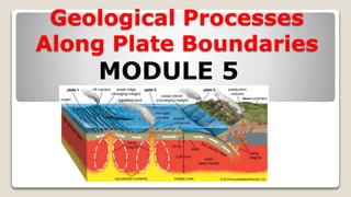
- 1. Geological Processes Along Plate Boundaries MODULE 5
- 2. Online Class Opening Prayer
- 3. Geological Processes Along Plate Boundaries MODULE 5
- 4. Geological Processes Along Plate Boundaries MAP OF TECTONIC PLATES
- 5. MAJOR AND MINOR PLATES
- 6. LET’S IDENTIFY SOME OF THE PLATES PACIFIC PLATE NORTH AMERICAN PLATE EURASIAN PLATE ANTARCTIC PLATE SOUTH AMERICAN PLATE AFRICAN PLATE INDO- AUSTRALIAN PLATE PHILIPPINE PLATEINDIAN PLATE NAZCA PLATE CARRIBEAN PLATE ARABIAN PLATE JUAN DE FUCA PLATE
- 8. Geological Processes Along Plate Boundaries CONVERGENT PLATE BOUNDARIES
- 9. Convergent boundary – where crust is destroyed as one plate dives under another. Also known as DESTRUCTIVE PLATE BOUNDARY “COMPRESSION” STRESS
- 10. A. Oceanic plate-Continental Plate Convergence
- 11. Oceanic-Continental Convergence From the diagram, it is clear that this event give rise to the formation of a VOLCANIC ARC near the edge of the continental plate The reason for this is because the denser oceanic crust undergoes SUBDUCTION PROCESS or the bending of crust towards the mantle. Since the mantle is HOTTER than the crust, the tendency is, the subducted crust melt forming MAGMA.
- 12. A. Oceanic plate-Continental Plate Convergence Accretion- Sediments, the top layer of material on a tectonic plate, that accumulate and deform where oceanic and continental plates collide.
- 14. ANDES MOUNTAIN The Andes Mountains line the western edge of South America, from Venezuela all the way along Chile to South America's southern tip, crossing through Ecuador, Peru, and Bolivia.
- 17. Oceanic-Continental Convergence For oceanic crust, one important geologic features formed is the TRENCH, also called SUBMARINE VALLEYS, ocean trenches are the deepest part of the ocean. One of the Deepest is the PHILIPPINE TRENCH with a depth of 10,540 meters. Another subsequent effect of continuous grinding of plate against each other is the occurrence of EARTHQUAKES.
- 18. MARIANAS TRENCH
- 19. The Mariana Trench and surrounding terrain is seen in this graphic.
- 20. Mariana Trench via Google Earth: the Deepest Part of the Planet Earth
- 21. Converging Oceanic Crust and Oceanic Crust
- 22. B. Converging Oceanic Crust and Oceanic Crust
- 23. Example of Ocean-Ocean Convergence
- 24. Oceanic plate-oceanic plate Convergence Converging two oceanic plates will cause formation of TRENCHES, these trenches will become sources of earthquakes. Underwater earthquakes, especially the stronger ones, can generate TSUNAMIS, The Japanese term for HARBOR WAVE. TSUNAMIS is a series of ocean waves with very long wavelengths ( hundreds of kilometers) caused by a large-scale disturbances under the ocean.
- 25. Oceanic plate-oceanic plate Convergence The leading edge of the SUBDUCTED PLATE, will eventually reach the mantle causing it to melt and turn into MAGMA, The molten material will rise to the surface creating a VOLCANIC ISLAND ARC parallel to the TRENCHES, VOLCANIC ISLAND ARC is a chain of volcanoes position in an arc shape.
- 26. FORMATION OF PHILIPPINE ARCHIPELAGO Many parts of the Philippines originated from oceanic-oceanic convergence. Philippine Archipelago are considered as part of the PHILIPPINE MOBILE BELT. This island were formed 65 millions years ago at the southern edge of the Philippine Sea Plate and are considered as part of the island arcs. Philippine Islands are formed dues to the convergence of the Philippine Plate and the Eurasian Plate.
- 29. FORMATION OF PHILIPPINE ARCHIPELAGO Other parts of the PHILIPPINES, such as PALAWAN, MINDORO and ZAMBOANGA PENINSULA are all high land section of the SUNDALAND BLOCK of the EURASIAN PLATE. The Philippine Mobile Belt eventually collided with the sundaland block which explains the presence of TRENCHES, such as MANILA- NEGROS-COTABATO TRENCH SYSTEM and the SULU TRENCH.
- 31. Example of Ocean-Ocean Convergence
- 32. How Aleutian Islands Formed?
- 34. Continental-Continental Plates Convergence When two continental plates converge, a COLLISION ZONE is formed. No occurrence of SUBDUCTION. No TRENCH, no VOLCANO and definitely no ISLAND ARC are created. Instead, what created is a large group of tall mountains called MOUNTAIN RANGE parallel to a HIGH PLATEAU.
- 36. Continental-Continental Plates Convergence About 40-50 million years ago, two large land mass, INDIA and EURASIA, collided to begin the formation of the most visible product of plate tectonics- THE HIMALAYAS. Also collision of continental plates is associated with shallow earthquake activities.
- 37. THE HIMALAYAS
- 38. HOW HIMALAYAN MOUNTAIN FORMED?
- 39. HIMALAYAN MOUNTAIN The Himalayas stretch across the north eastern portion of India. They cover approximately 1,500 mi (2,400 km) and pass through the nations of India, Pakistan, Afghanistan, China, Bhutan and Nepal.The range has many of Earth's highest peaks, including the highest, Mount Everest, at the border between Nepal and China
- 41. How were Appalachians Mountains Formed? The Appalachian Mountains resulted from ancient convergence when Pangaea came together.
- 45. Divergent boundary – where new crust is generated as the plates pull away from each other. Also known as CONSTRUCTIVE PLATE
- 46. Fracture zone and Fissures
- 47. DIVERGENT BOUNDARY Formation of RIFT VALLEYS and OCEANIC RIDGES are indications that the crust is spreading or splitting apart. When spreading center develops within continent, the crust may break into several segments. The breaking leads to faulted valleys called RIFT VALLEYS.
- 51. East African Rift Valley
- 53. The rift valley increases its length and depth as the spreading continues. At this point, the valley develops into a linear sea, similar to the Red Sea today.
- 54. The Biblical Red Sea
- 55. The Red Sea
- 57. DIVERGENT BOUNDARY Most divergent boundaries are situated along underwater mountain ranges called OCEANIC RIDGES. As the plates separates, new materials from the mantle ooze up to fill the gap. These materials will slowly cool to produce NEW OCEAN FLOOR.
- 58. DIVERGENT BOUNDARY The MID-ATLANTIC OCEAN RIDGE is an example of spreading center which causes the divergence of the SOUTH AMERICAN PLATE and AFRICAN PLATE.
- 59. Visible surface of Mid Atlantic Ridge in Iceland Slicing through the center of Iceland is the Mid-Atlantic Ridge. This is the boundary between the North American and Eurasian tectonic plates.
- 60. Where does the Mid Atlantic Ridge surface? In the Atlantic Ocean, the mid- ocean ridge is called the Mid- Atlantic Ridge. It curves from the Arctic Ocean southward, through Iceland, down the center of the Atlantic, and around the bottom of Africa. Thingvellir National Park, in southwestern Iceland, is one of the few spots in the world where an underwater ridge rises above the water surface.
- 61. MID-ATLANTIC RIDGES THAT RUNS IN THE SURFACE
- 63. MID-ATLANTIC RIDGE UNDERWATER The Silfra fissure, a popular dive and snorkel tour location, is also located within Thingvellir National Park on the northern shore of Thingvallavatn, the largest natural lake of Iceland. Here tourists, donning scuba gear, can dive between the two tectonic plates.
- 65. WHAT IS A RIDGE? a long narrow hilltop, mountain range, or watershed that form a continuous elevated crest for some distance. An oceanic ridge technically an “UNDERWATER MOUNTAIN”
- 66. Transform boundary – where crust is neither produced nor destroyed as the plates slide and grind horizontally past each other. Also known as CONSERVATIVE PLATE BOUNDARY
- 67. When forces are parallel but moving in opposite directions, the stress is called shear. Shear stress is the most common stress at transform plate boundaries.
- 68. TRANSFORM BOUNDARY San Andreas Fault
- 69. VIDEO: San Andreas Fault
- 70. TSUNAMI
- 71. A VIDEO ANIMATION: HOW TSUNAMI WERE FORMED?
- 74. Let’s See What you have learned? Short Quiz
- 75. 1. Where do most earthquakes happen? A. Along the plate boundaries. B. in the earth’s mantle C. near the center of the tectonic plates D. in the earth’s core
- 76. 2. As a new seafloor is formed at the mid- ocean ridge, the old seafloor farthest from the ridge is destroyed. Which of the stated processes describes how the oceanic crust plunges into the earth and destroyed at the mantle? A. Convection B. Construction C. Diversion D. Subduction
- 77. 3. At a convergent plate not all lithospheric plates are made of equally dense rock, subduction zone is a long, narrow belt where a lithospheric plate is sinking into the mantle. Why does the oceanic crust sink beneath the continental crust at the subduction zone? A. The oceanic crust have high density than the continental crust and is pushed from the ridge. B. The oceanic crust is pulled downward by earth’s magnetic field. C. The continental crust have denser composition
- 78. 4. What do you expect to find parallel to a trench? A. hot spot B. mountain range C. ocean ridge D. volcanic arc
- 79. 5. Which island is not associated with an oceanic- oceanic convergent boundary A. Aleutian Islands C. Marianas Islands B. Hawaii Islands D. Philippine Islands
- 80. 6. Which geologic event will NOT occur in San Andreas Fault? A. Strike and slip fault B. Shallow Earthquake C. Sliding of two plates D. Great Tsunami
- 81. 7. Which geologic structure is a piece of evidence that the seafloor creates new ocean floor? A. The formation of the Red Sea B. Expansion of the Mid Atlantic Ridge C. Formation of Volcanic Arc D. Formation of Trenches
- 82. 8. What geologic activity takes place in a convergent continental-continental boundary? A. Earthquake B. Mountain Building C. Seafloor Spreading D. Volcano Forming
- 83. 9. What land feature is formed at a divergent oceanic- oceanic boundary? A. Deep Ocean Trench B. Pacific Hot Spot C. Mid Ocean Ridge D. Rift Valley
- 84. 10. Which of the world's geological features is not formed in the divergent boundary? A. The Great Rift Valley of East Africa B. The San Andreas Fault C. The East Pacific Rise D. The Mid Atlantic Ridge
- 85. LET’S CHECK YOUR ANSWER Short Quiz
- 86. 1. Where do most earthquakes happen? A. Along the plate boundaries B. in the earth’s mantle C. near the center of the tectonic plates D. in the earth’s core
- 87. 2. Which of the stated processes describes how the oceanic crust plunges into the earth and destroyed at the mantle? A. Convection B. Construction C. Diversion D. Subduction
- 88. 3. At a convergent plate not all lithospheric plates are made of equally dense rock, subduction zone is a long, narrow belt where a lithospheric plate is sinking into the mantle. Why does the oceanic crust sink beneath the continental crust at the subduction zone? A. The oceanic crust have high density than the continental crust and is pushed from the ridge. B. The oceanic crust is pulled downward by earth’s magnetic field. C. The continental crust have denser composition
- 89. 4. What do you expect to find parallel to a trench? A. hot spot B. mountain range C. ocean ridge D. volcanic arc
- 90. 5. Which island is not associated with an oceanic- oceanic convergent boundary A. Aleutian Islands C. Marianas Islands B. Hawaii Islands D. Philippine Islands
- 91. 6. Which geologic event will NOT occur in San Andreas Fault? A. Strike and slip fault B. Shallow Earthquake C. Sliding of two plates D. Great Tsunami
- 92. 7. Which geologic structure is a piece of evidence that the seafloor creates new ocean floor? A. The formation of the Red Sea B. Expansion of the Mid Atlantic Ridge C. Formation of Volcanic Arc D. Formation of Trenches
- 93. 8. What geologic activity takes place in a convergent continental-continental boundary? A. Earthquake B. Mountain Building C. Seafloor Spreading D. Volcano Forming
- 94. 9. What land feature is formed at a divergent oceanic- oceanic boundary? A. Deep Ocean Trench B. Pacific Hot Spot C. Mid Ocean Ridge D. Rift Valley
- 95. 10. Which of the world's geological features is not formed in the divergent boundary? A. The Great Rift Valley of East Africa B. The San Andreas Fault C. The East Pacific Rise D. The Mid Atlantic Ridge
- 96. I HOPE YOU LEARNED A LOT TODAY!
Editor's Notes
- the Cascade Range is almost entirely volcanic in origin. The volcanoes and their eroded remnants are the visible magmatic expression of the Cascadia subduction zone, where the offshore Juan de Fuca tectonic plate is subducted beneath North America.
- What is it like in a trench? The great depth of ocean trenches creates an environment with water pressures more than 1,000 times greater than the surface, constant temperatures just above freezing, and no light to sustain photosynthesis. While this may not seem like conditions suitable to life, the combination of extremely high pressure, the gradual accumulation of food along trench axes, and the geographical isolation of hadal systems are believed to have created habitats with an extraordinarily high abundance of a few highly specialized organisms.
- fracture is any separation in a geologic formation, such as a joint or a fault that divides the rock into two or more pieces. A fracture will sometimes form a deep fissure or crevice in the rock.
- Why it is called the Red Sea? There are numerous hypotheses hovering over without certainty. The red sea water contains red coloured cyanobacteria (Trichodesmium erythraeum) which turn the blue-green water to a reddish-brown. 2)The “Red Sea” is in fact “Sea of Reed”,( a tall slender leaved plant of the grass family growing in water or marshy area.) most likely due to the reeds of the Gulf of Suez. A hypothesis favoured by modern scholars is that the name “red” refers direction of “South” just as the Black Sea refers to “North”. Sea’s located south of the Mediterranean world. In ancient languages, the colours black, red, green, and white referred to North, South, East, and West, respectively. Herodotus (a Greek historian who lived 484-425 BC) on one occasion uses Red Sea and Southern Sea interchangeably.
- The red sea water contains red coloured cyanobacteria (Trichodesmium erythraeum) which turn the blue-green water to a reddish-brown.
- Iceland represents the largest portion of the mid-Atlantic ridge exposed above sea level. Formed from volcanic eruptions on the Mid-Atlantic ridge, about 24 million years ago, it is one of the few places where you can stand on the ridge on dry land. This makes Iceland very special and a popular place for geologists and scientists.
- a special case in Iceland where ridges rise above the surface