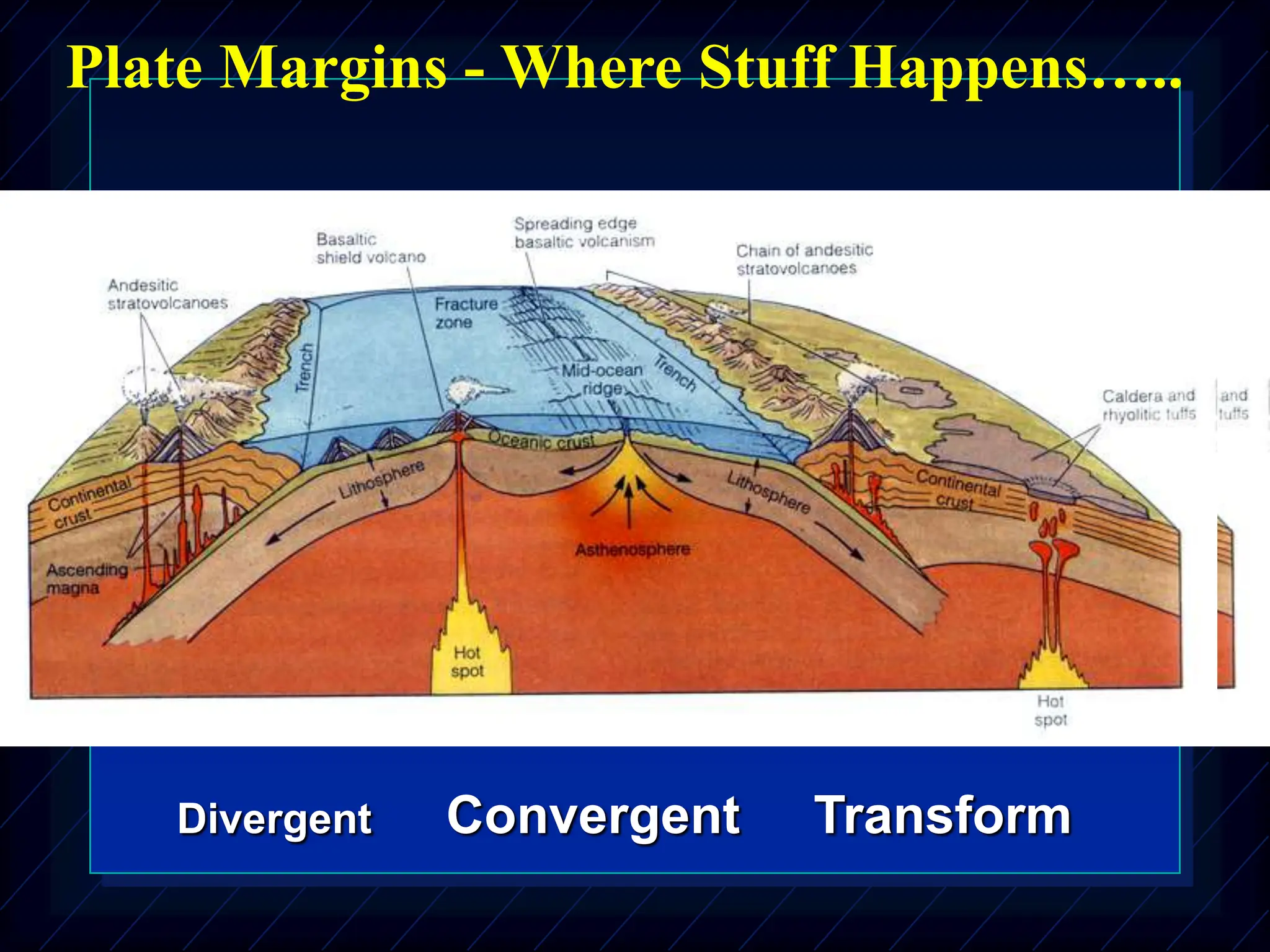
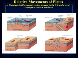
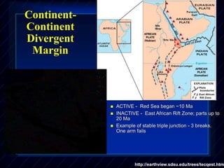
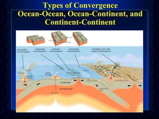
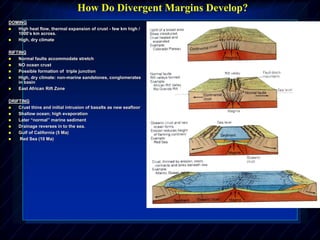
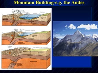
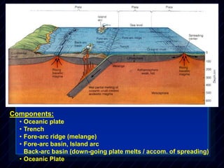
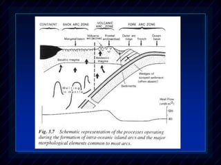
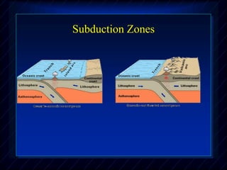
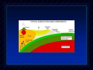
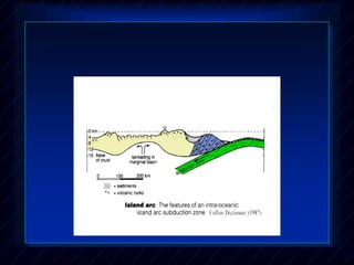
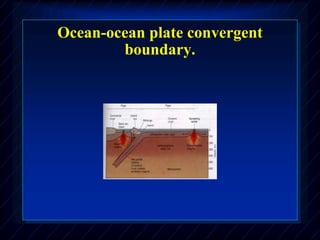
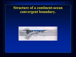
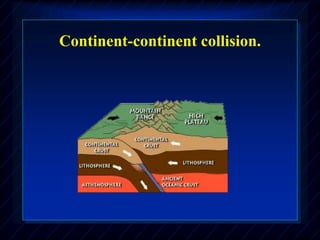
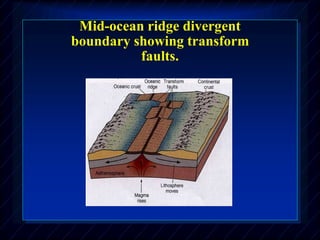
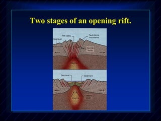
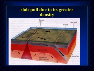
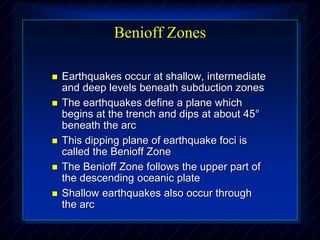
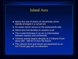
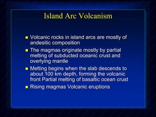
SlideShare a Scribd company logo
1 of 79
Plate Margins - Where Stuff Happens…..
Divergent Convergent Transform
Relative Movements of Plates
a) Divergent, (b) Convergent-continent/ocean basin, © transform, (d)
convergent-continent/continent
http://earthview.sdsu.edu/trees/tecqest.htm
 ACTIVE - Red Sea began ~10 Ma
 INACTIVE - East African Rift Zone; parts up to
20 Ma
 Example of stable triple junction - 3 breaks.
One arm fails
Continent-
Continent
Divergent
Margin
Types of Convergence
Ocean-Ocean, Ocean-Continent, and
Continent-Continent
DOMING
 High heat flow, thermal expansion of crust - few km high /
1000’s km across.
 High, dry climate
RIFTING
 Normal faults accommodate stretch
 NO ocean crust
 Possible formation of triple junction
 High, dry climate: non-marine sandstones, conglomerates
in basin
 East African Rift Zone
DRIFTING
 Crust thins and initial intrusion of basalts as new seafloor
 Shallow ocean; high evaporation
 Later “normal” marine sediment
 Drainage reverses in to the sea.
 Gulf of California (5 Ma)
 Red Sea (10 Ma)
How Do Divergent Margins Develop?
Components:
• Oceanic plate
• Trench
• Fore-arc ridge (melange)
• Fore-arc basin
• Continental plate with volcanic mountain range (e.g. Andes)
Mountain Building-e.g. the Andes
Components:
• Oceanic plate
• Trench
• Fore-arc ridge (melange)
• Fore-arc basin, Island arc
Back-arc basin (down-going plate melts / accom. of spreading)
• Oceanic Plate
Volcanic arcs may develop...
 within oceanic lithosphere, where ocean floor
subducts beneath ocean floor, and an island arc
results, e.g. Lesser Antilles arc
 or at the edge of a continent, where oceanic
lithosphere subducts beneath continental
lithosphere, and a continental margin magmatic arc
forms, e.g. Andes
Basins related to volcanic arcs
 fore-arc
 back-arc
 intra-arc
 All may be either submarine or
subaerial, or may have marine &
subaerial parts
 Much sediment is supplied from
active arc.
Fore-arc basins
 Lie in the arc-trench gap, between
volcanic arc and submarine trench
 range from small basins on trench
slope to large basins (50 to 100 km
wide, and > 500 km long) with thick
fills (several km)
 Basins tend to become wider and
shallower with time, partly because of
accretion at trenches
fore-arc basins
Sediment sources:
 volcanic arc
 outer arc
 longitudinally from
a continent
Tectonic style varies:
 compressional
 extensional
 strike-slip
Back-arc basins
 lie behind the magmatic arc
 often the site of extension & thinning of crust
 may overlie either ocean or continental crust
 oceanic back-arc basins are eventually
subducted and destroyed, or preserved in
thrust complexes related to ocean closure.
 back-arc basins on continental crust - more
varied facies, because of terrigenous input;
higher preservation potential.
Intra-arc basins
 Sedimentary basins within magmatic arcs,
between volcanoes, or between older and
younger belts of the arc
 Some are fault-bounded and subside rapidly.
Faulting due to extension within arc, or
flexure of lithosphere due to weight of
volcano.
 With time, position of the arc migrates, and
basins may change between intra-arc, back-
arc and fore-arc.
Sediment supply and transport
 Sediment supply varies according to volcano
behaviour, governed by magma viscosity and
gas content.
 In deep water, explosive activity is suppressed
by hydrostatic pressure.
 More silicic magmas in more evolved arcs -
therefore greater explosive activity, more supply
of pyroclastic sediment.
Sediment transport and deposition is
controlled by:
 topography - both subaerial and
submarine
 volcanic processes, especially eruption
column height, direction of pyroclastic
flows
 sediment transport systems - e.g. rivers,
prevailing winds
Subduction Zones
Subduction zones
 also termed convergent or consuming plate margins
 occur where adjacent plates move toward each other
and relative motion is accommodated by one plate
over-riding the other.
 These zones are classified as either oceanic or
subcontinental, depending on the overriding plate.
 If the "subducting" plate is continental, subduction
will cease and a mountain belt will form within a
collision zone.
Where do subduction zones occur?
 along the "Ring of Fire" around the Pacific Ocean.
 Two short subduction zones occur at the Lesser
Antilles, at the eastern side of the Carribean plate
and the South Sandwich Island plate.
 Three short segments of the Alpine Himalayan
system involve subduction of oceanic lithosphere.
– the Calabrian and Aegean boundaries in the Mediterranean
Sea
– Makran boundary along the SW boundary of the Iran plate.
Physiography
 Outer Swell
 Outer Trench Wall
 Trench
 Forearc (Arc-Trench Gap)
 Volcanic Arc
 Back-Arc
Physiography 2
 Outer swell
– Low topographic bulge (a few hundred meters of relief)
– develops just outboard of where subducting plate
bends down into the mantle.
Outer Trench Wall
– Slope on ocean floor between the outer swell and the
trench floor.
– Slope dip is typically -5 degrees
 Trench
 - A trough upto 11 km deep infront of arc and final
repository of most arc derived sediments.
– Deep valley that develops at the plate boundary.
– Continuous for 1000s of km
– Turbidites and pelagic typically are present here
but are deformed and overriden by subduction
complexes. Many trench are essentially empty of
sediments because of the absence of any
adjacent sediments supply.
Forearc (Arc-Trench Gap)
– Consists of region between trench and the arc.
– steep inner trench wall (lower trench slope)
 dips of - 10 deg
– flattens into a gentle slope termed the forearc basin
(upper trench slope).
– The inner trench wall is usually separated from the
forearc by the outer ridge.
– The accretionary prism underlies the inner trench wall,
the outer ridge and part of the forearc basin.
Volcanic Arc
 Active arc built on a topographically high region of
older rocks, the arc basement
 may be a shallow marine platform or an emergent
region of older rocks.
 In continental arcs, the basement is continental crust
standing a few kms above sea level.
 Volcanoes in island arcs are usually 1 - 2 km above
sea level. Volcano elevation in continental arcs is
strongly influenced by continental crust thickness.
Back-Arc
 Area behind the volcanic arc.
 In island arcs this region consists of basins with oceanic
crustal structure and abyssal water depths.
 Sometimes remnant arcs are preserved behind the island
arcs.
 On continents this region is the continental platform which
may be subaerially exposed, or the site of a shallow marine
basin.
Gravity
 Typically, similar free-air gravity profiles
– 50 mGal gravity high associated with the outer bulge
– 200 mGal low associated with the trench and accretionary prism
– 200 mGal high associated with the arc.
 Isostatic anomalies have the same polarity as the free-air
gravity
 Suggests that the gravity anomalies are caused by the
dynamic equilibrium imposed by the system by compression.
 Compressional forces cause the trench to be deeper and the
arc to have less of a root than they would be if only isostatic
forces were at work.
Structure from Earthquakes
 Subduction zones are characterized by
dipping seismic zones termed Benioff zones
or Wadati-Benioff zones
 Result from deformation of the downgoing
lithospheric slab. The zones have dips
ranging from 40 to 60 deg
 Because, the slab is colder and more dense
than surrounding asthenosphere, it's
position can be mapped seismically as high
velocity anomalies and as high "Q" (little
attenuation of seismic waves) zones in the
mantle. High Q, and high velocity are
thought to correspond to relatively high
density, cold material
earthquake hypocenters
related to their position within
the slab
 Shallow depths
 predominantly thrust faults within the upper
part of the downgoing plate or in the adjacent
overriding plate.
 Down to depths of 400 km, down-dip extension.
– In some slabs, down-dip extension is found in the upper
part of the slab, accompanied by down-dip
compression at the base of the slab. The extension
probably results from the lithosphere being pulled into
the mantle by the weight of the downgoing portion.
 Deep slabs usually show down-dip compression
– may result from increased viscous resistance at depth.
– deeper part of the slab will feel a push from the weight of the shallower
portion of the slab.
 Between 70 - 300 km, faulting may occur due to dehydration
of serpentinite.
 From 300 - 700 krn may also be due to the sudden phase
change of olivine to spinel which may be accommodated by
rapid shearing of the crystal lattice along planes on which
minute spinel crystals have grown.
Structural Geology- Trenches
 Trenches normally contain flat-lying
turbidites deposited by currents flowing
down into the trench from the overriding
plate or along the axis of the trench. The
outer swell is probably caused by elastic
bending of the subducting plate.
Forearc
 may be underlain either by the accretionary prism or
arc basement rocks covered by a thin veneer of
sediments or both.
 Where there is little sediment accumulation on the
subducting plate, island arc or continental basement
may extend all the way to the lower trench slope and
little or no accretionary prism may occur.
 Forearc basement may draped by a thin veneer of
sediment, and is commonly cut by normal faults
toward the trench.
Accretionary Prism
 wedge of deformed sedimentary rocks
 the main locus of crustal deformation
 Rocks are typically cut by numerous imbricate
thrust faults that dip in the same direction as
the subduction zone.
 As more material is added to the toe of the
wedge, the thrusts are moved upwards and
rotate arcwards.
 Rocks within the accretionary prism are derived
from the downgoing and/or overriding plates.
Accretionary Prism
 At the toe of the wedge, sediments are
added thru offscraping
 propagation of the basal thrust into
undeformed sediments on the
subducting plate.
 This process results in progressive
widening of the wedge, and eventually a
decrease in dip on the subduction zone.
Accretionary Prism
 When sediments on the downgoing plate are
subducted without being disturbed they can
still be added to the prism thru underplating
 propagation of the basal thrust into the
downgoing undeformed sediments to form a
duplex beneath the main part of the prism.
Subduction Erosion
 erosion and subsequent subduction of
rocks from the toe of the prism.
 Sediment on the subducting plate that is not
added to the overriding plate thru these
processes may descend into the mantle and
contribute to the generation of arc magmas.
Forearc Basin
 Wide sedimentary basin
– develops above irregular basement on the upper part of the arc-trench
gap.
– Sediments from the active arc or arc basement rocks
 deposited by turbidity currents traveling along the basin axis or
perpendicular to the arc.
 asymmetric basin
– inner part of the upper slope basin subsides
– outer edges rises due to accretion at the toe of the wedge.
 high-P, low-T metamorphism
– increases in grade toward the inner forearc region
– in the direction of subduction
Arc
 Arc basement
– older more deformed and metamorphosed rocks in platform on which
the modem arc is built.
– oceanic rocks
– On the continents, complex continental basement.
 Volcanic arc
– a chain of largely andesitic stratovolcanoes spaced at fairly regular
intervals of 70 km.
– The structural environment of these arcs is commonly extensional
(numerous normal faults)
– volcanoes in grabens termed volcanic depressions.
– underlain by large plutonic bodies (e. g. the Sierra Nevada).
Arcs
 Metamorphism
– common and suggest a high geothermal gradient.
– Much of the lower crust may be at the melting
temperature of granite.
 Sediments
– debris from active volcanoes.
– deposited as turbidites.
– In tropics, settings these volcanogenic sediments may
interfinger with carbonate reefs.
– In continental arcs, sediments are often deposited subaerially.
Back-arc
 extensional tectonics and subsidence.
 In oceans arc-derived sediments are
deposited in an ocean basin behind the arc
termed the back-arc basin.
 In continents, sediments are deposited into
basins on the continental platform and are
termed foreland basins or retro-arc basins.
Foreland Fold and Thrust Belts
 Relation between foreland fold and thrust belts
and subduction not understood
 not all continental arcs display these features.
 Possible explanations if there is a relation
– Thrust belt caused by compression at margin of
overriding plate due to subduction of hot, buoyant
lithosphere.
– Thrust belt associated with shallow dip of a downgoing
slab.
– Thrust belt associated with subduction of an aseismic ridge.
Models of thermal processes in
subduction zones
 Rate of Subduction
– The faster the descent of the slab, the less time it has to
absorb heat from the mantle.
 Slab Thickness
– The thicker the descending slab, the more time it takes
to come into equilibrium with the surrounding
lithosphere.
 Frictional Heating
– occurs at top of slab due to friction as slab descends
and is resisted by the lithosphere.
 Conduction
– heat into slab from the asthenosphere
 Adiabatic Heating
– associated with compression of slab with increased pressure at depth.
 Heat of Radioactive Decay
– decay of radioactive minerals in the oceanic crust (minor)
 Latent Heat of Mineral Phase Transitions
– olivine-spinel transition at 400 km is exothermic. Spinel-oxide transition at
670 km could be either exothermic or endothermic.
 All thermal models show that the
downgoing slab maintains its thermal
identity to great depths (e. g. contrasts
of 700 deg C can still exist at 700 krn
depth).
If the slab is so cold, how do we get
enough heating to cause arc
magmatism?
 Melting of Slab in Presence of Water
– Partial melting may take place at lower temperatures
due to presence of water as slab dehydrates. Water is
released by transition of amphibolite to ecologite, and
dehydration of serpentinite at depths of - 100 km.
 Corner Flow and Melting of Mantle
– Downgoing slab may cause flow of hot mantle into the
comer of the overriding mantle where it impinges on the
downgoing slab. This may provide enough heat to
cause melting.
Origins of back-arc basins
 Entrapment of previous oceanic crust
– Change of plate motion may lead to abandonment of a fragment of
oceanic crust behind the arc. (e.g., Aleutian Basin and West
Philippines Basin )
 Formation of new crust - behind the arc. 3 models
o Spreading caused by forceable injection of a diapir rising from the
downgoing slab.
o Spreading induced in the overriding plate by the viscous drag in the
mantle wedge caused by the motion of the downgoing plate (comer
flow).
o Spreading induced by the relative drift of the overriding plate away
from the downgoing slab (slab fixed with respect to mantle). This is
also termed roll-back.
Ocean-ocean plate convergent
boundary.
Structure of a continent-ocean
convergent boundary.
Continent-continent collision.
Mid-ocean ridge divergent
boundary showing transform
faults.
Two stages of an opening rift.
slab-pull due to its greater
density
Reconstruction @ 250 million
years ago
Concept of a Basin
 Three dimensional architecture of basin fill.
 Affected by spatial and temporal pattern of
tectonic subsidence:
– Lithospheric deformation process.
– Three basic causes of subsidence:
 Loading and flexure (like an elastic plate).
 Thermal and density changes - isostasy.
 Faulting - isostasy.
 Sea level changes.
 Sediment supply rates and source position
(drainage basin outlets).
Basin Classification
 Extensional:
– Half graben/graben - Rift Basin, e.g. Basin and Range,
U.S.A.
– Mature oceanic speading - e.g. Atlantic margin (Passive
Margin).
– Syn-rift, post-rift megasequences.
 Compressional:
– Foreland basin - flexural loading of the Earth's
lithosphere.
– Two types:
 Collisional, e.g. Himalaya.
 Back arc, e.g. Andes/Precordillera.
– Piggy-back basin (thrust sheet top basin).
 Strike-Slip Basins:
– E.g. Dead Sea, Israel.
Basin Classification Cont.
 Passive Margins:
– E.g. Atlantic Margin.
 Subduction Related:
– Oceanic trench, e.g. Marianas Trench.
– Fore-arc basin, e.g Taiwan or Median Valley in Scotland.
– Back-arc basin, e.g. Sea of Japan.
 Cratonic "sag" Basins:
– E.g. Chad Basin, Africa.
 Abyssal Plains.
 Predictive models of facies distributions:
useful for subsurface exploration of oil or
understanding dispersal of pollutants.
Benioff Zones
 Earthquakes occur at shallow, intermediate
and deep levels beneath subduction zones
 The earthquakes define a plane which
begins at the trench and dips at about 45°
beneath the arc
 This dipping plane of earthquake foci is
called the Benioff Zone
 The Benioff Zone follows the upper part of
the descending oceanic plate
 Shallow earthquakes also occur through
the arc
Island Arcs
 Island arcs are of chains of volcanically active
islands arranged in a curved arc
 An ocean trench occurs on the oceanwards side
 Island arcs first develop on oceanic crust
 The crustal thickness in an arc is intermediate
between oceanic and continental
 Volcanic activity begins abruptly at a Volcanic Front
about 200 - 300 km in from the trench
 The volcanic front and trench are separated by an
Arc-Trench gap with no volcanism
Island Arc Volcanism
 Volcanic rocks in island arcs are mostly of
andesitic composition
 The magmas originate mostly by partial
melting of subducted oceanic crust and
overlying mantle
 Melting begins when the slab descends to
about 100 km depth, forming the volcanic
front Partial melting of basaltic ocean crust
 Rising magmas Volcanic eruptions
Chemical Differentiation
 Mid-Ocean Ridge:
Partial melting of Mantle basalt magma
 Subduction Zone:
Partial melting of Basalt crust andesite magma
 Mature Arcs:
Partial melting of Andesite crust rhyolite
magma
 All of this is an irreversible chemical differentiation
of the mantle in several stages
 Continental crust grows by accumulation of
increasingly silica-rich rocks
Ocean trench Sedimentation
 Unconsolidated sediment from the ocean floor is
scraped off the descending plate at the trench
 Slices of the oceanic crust may be included as
ophiolite belts
 These rocks form a complex rock mass called an
Accretionary Wedge
 The Accretionary Wedge is buckled upwards as
new material is pushed beneath its base
 The chaotic jumble of rocks in the Accretionary
wedge is called a Tectonic Mélange Accretionary
Wedge
Metamorphic Rocks and
Subduction
 High Temp - Low Pressure
 Metamorphism
 Occurs in the core of volcanic arcs
– Abnormal heating of the crust
– thermal effects of subduction-related magmatism
 High Pressure-Low Temp
 Metamorphism
– occurs in the accretionary wedge
– cold rocks are dragged to great depths and then
upthrust again Granites
Basin Analysis
 Basins
– Topographically low places where sedimentary
– materials accumulate.
– Basins are characterized by accomodation space.
– Accomodation is created by…
– Eustatic sea-level rise
– Subsidence
Basin Analysis
Basin analysis is the detailed investigation of
the processes that
– Form basins
– Fill basins
– Alter basins
– Uplift (invert) basins
– Destroy basins
– Requires sedimentology, stratigraphy, hydrogeology,
petroleum geology, seismology, geophysics,
geochemistry, paleontology, etc.
Types of Basins
 Intracratonic
 Rift related
 Strike-Slip related
 Collision / Subduction related
 _Intracratonic – Basins that form within
continental crust _Intracratonic – Basins
that form within continental crust
 Rifts – Divergent plate boundaries that
eventually develop into spreading centers.
 Rifts – Divergent plate boundaries that
eventually develop into spreading centers.
 _Initial rift sediments are arkosic
sandstones interbedded with basalts.
 _Rifts then flood and deposit a thick
sequence of evaporites.
 _Then marine sedimentationtakes over.
Basins & basin types
Basin: a region of depressed crust, typically with
greater thicknesses of sediment accumulation
than surrounding regions.
– Basins form by tectonic processes that cause
the crust to subside, and so to create large
amounts of accommodation space. Rapid A-
space growth translates into abundant and well-
preserved organic matter within the sediment.
– The abundance of organic matter combined
with the low grade burial metamorphism that
sediments in thick accumulation experience
translate into major oil and gas accumulations.
– Basins provide the most complete successions
of the geological record.
Tectonic setting for the
majority of basins
Constructive (spreading) margins: This setting produces
a genetic series of basins from localized rift-related
basins through narrow oceans (Red Sea phase) to
voluminous passive margin basins.
Destructive (convergent) margins: This setting produces
basins associated with subduction zones (foredeep
basins), intra-arc spreading basins, back-arc
spreading basins (Sea of Japan, Great Basin), and
back-arc thrust (foreland) basins.
Transform (strike-slip) margins: mostly localized pull-
apart basins such as the Gulf of California and Dead
Sea. Grades into rift-type and thrust-type tectonics
where relative plate motion is not fully strike-slip
(i.e., transtensional and transpressional regimes).
Intra-cratonic basins. Fairly mysterious, concentrically
subsiding basins formed on continental crust well
away from plate boundaries. The cause of
subsidence is unknown, but is generally considered
to involve some combination of density-driven
stress and in-plane stress.
Rifting and passive margin
 Continental rifting begins with dome-formation. Produced
by hot-spot volcanism (bimodal: dominantly basaltic plus
some rhyolite from partial melting of the crust by basaltic
magma and decompression melting).
 Much extension by normal-faulting. Individual domes link
up to form a more or less continuous series of rift valleys
(grabens, as in the East African Rift zone). Extension
results in thinning of the upper crust. The lower crust
thins by ductile flow.
 High heat flow produces thermal uplift; uplift leads to
further thinning of the upper crust by erosion.
 Continued extension produces oceanic crust between the
newly formed, thinned continental margins. Eventually
(over 107 years), sea floor spreading and thermal
subsidence yields a distinct mid ocean ridge, open
communication with the oceans (Red Sea phase) to form a
permanent seaway.
 Continued seafloor spreading carries the new continental
margins away from the active tectonic zone. The much-
extended crust cools and subsides over the next 108 yrs.
as a passive continental margin ("passive margin," for
short).
Rift basins.
 Smallish volumes of sediment (100’s to a few
1000 m of accommodation space) in
localized, fault-bounded basins.
 Dominantly terrestrial (subaerial and
lacustrine) and arid as result of uplifted
margins that cast rain-shadows into the
basins as well as their small drainage
capture area.
 Early rift sediments typically heterogeneous
with basement clasts and volcanics
dominant. Grains with low physical and
chemical maturity. Late rift sediments often
include extensive evaporites from episodic
oceanic invasions (reflects variable rates of
subsidence and sea level rise and fall).
Remobilized salt becomes important in
passive margin history later (see below).
Passive margin basins.
 Lots of accommodation space (10,000 to 15,000 m or
more) from combination of thermal and sediment load-
driven subsidence.
 As oceans widen, marine conditions come to dominate.
Early phases often still arid and dominated by carbonate
deposition and fringing reefs along the shelf edge (at low
latitude sites)
 With continued subsidence the fringing mountains
diminish, drainage basin size grows, and clastic sediment
supply rates increase. In humid regions or times of low
sea level, deposition switches to the clastic off-lap suite
with formation of the familiar shelf environments: typical
association of deltas, beaches, and sub-tidal clastic shelf
deposits grading outward to deep sea fans and
contourites in continental rise settings. Prograding
sediments build a wide continental shelf upon a
voluminous accumulation of clastic or carbonate (or some
mix of clastic and carbonate).
 The clastic off-lap suite is well developed along the
present Atlantic coast of North America, South America,
Africa, and Europe. The southern passive margin of
Laurentia (what is now the eastern margin of North
America) was dominated in the Cambrian and Ordovician
entirely by carbonates. Both are major source of
petroleum.
Destructive (convergent)
margin basins
 Foredeep Basins
 Foreland Basins.
 Facies patterns.
Foredeep Basins
 Basin forming mechanisms: dominantly a combination of
load-related and density-related subsidence. Loading
leads to flexure of the crust. Subsidence near the load is
matched by a compensating (but smaller amplitude) up-
bend at the periphery of the down-bend.
 At destructive plate boundaries, dense, old oceanic crust
subducts beneath continental crust or younger, less-
dense oceanic crust, forming an elongate, deep oceanic
trench.
 Interaction between the down-going plate and the
overriding plate generates thrust slices (slabs of rock and
deformed sediment) sheared off of one or the other plate,
which are thrust ocean-ward, overtop of the down going
plate.
 The subduction zone may also include abundant sediment
supplied to the trench (especially in humid climates; ex.
central Andean margin of South America).
 Thrust and sediment load causes subsidence of the crust,
deepening the basin and creating large amounts of
additional accommodation space. This is a foredeep
basin: a basin that form from a combination of trench
(density driven) and load-driven subsidence in the down-
going (lower) plate. It is located ocean-ward of the
volcanic arc and is rimmed distally by an uplifted
forebulge. Ex: north Australian shelf-Banda Arc collision.
Foreland Basins.
 Thickened crust of an island arc complex or
continental crust at the margin of the upper plate
leads to intense interaction between the down-
going plate and the upper plate. This generates
considerable additional thickening and
deformation of the upper plate via thrust slices
that stack up to form (together with the volcanoes)
a tall, complex mountain system and its isostatic
roots. Ex: Andes Mountains.
 Thrusts migrate away from the collision
(subduction) zone toward the "foreland." Thrust
and sediment loads causes subsidence of the
crust forming a deep flexural basin (8-10 km
accommodation space) followed by an uplifted
forebulge and a much smaller second order basin
(a few 100’s of meters A-space at most). Ex:
Amazon Foreland Basin.
Facies patterns.
 Load-driven flexure is rapidly accommodated by
subsidence/uplift.
 Rapid growth of accommodation space in the foreland or
foredeep basin leads to trapping of sediments in the
source area and strong transgression and sediment
starvation as relative water depth increases over a period
of 104 - 105 years.
 Rapid uplift on the foreland or peripheral bulge results in
loss of accommodation space, but facies response varies
greatly with local conditions the state of eustatic sea
level. Possibilities range from subaerial exposure to
prograding carbonate or siliciclastic facies. Unlikely to
exhibit transgression.
 Basin fill shows strong progradation of sediments filling
deep basin. Sediments grade upward and proximally from
black shales to flysch (mixed shale and turbiditic
litharenites), to near shore clastics (deltaic and shelf-like
sediments) to alluvial plane deposits (fans & rivers, etc.).
Early basin fill with abundant, well preserved organic
material.
 As the system ages, the mountains erode and the
sediments become less volcanic, more plutonic and
metamorphic (granitic) source-rock dominated, and
become more mature both physically and chemically.
These late phase deposits are sometimes referred to as
mollasse.

More Related Content

Similar to 100007675.ppt

Basin margins and its formation mechanism.
Basin margins and its formation mechanism.Basin margins and its formation mechanism.
Basin margins and its formation mechanism.Usama Shah
 
Subduction and abduction zones
Subduction and abduction zonesSubduction and abduction zones
Subduction and abduction zonesPramoda Raj
 
Origin and destruction of ocean floor ppt ; ocean floor :evolution of ocean f...
Origin and destruction of ocean floor ppt ; ocean floor :evolution of ocean f...Origin and destruction of ocean floor ppt ; ocean floor :evolution of ocean f...
Origin and destruction of ocean floor ppt ; ocean floor :evolution of ocean f...Akash Nair
 
Continental Margins
Continental MarginsContinental Margins
Continental MarginsPRasad PK
 
TYPES OF SEDIMENTARY ENVIRONMENTS.ppt
TYPES OF SEDIMENTARY ENVIRONMENTS.pptTYPES OF SEDIMENTARY ENVIRONMENTS.ppt
TYPES OF SEDIMENTARY ENVIRONMENTS.pptSaadTaman
 
Grade 10_science1stquartermodule1.pptx
Grade 10_science1stquartermodule1.pptxGrade 10_science1stquartermodule1.pptx
Grade 10_science1stquartermodule1.pptxErlenaMirador1
 
Sedimentology Lecture 6. shelves & turbidites
Sedimentology Lecture 6. shelves & turbiditesSedimentology Lecture 6. shelves & turbidites
Sedimentology Lecture 6. shelves & turbiditesSigve Hamilton Aspelund
 
Economic geology - Metallogeny and plate tectonics
Economic geology - Metallogeny and plate tectonicsEconomic geology - Metallogeny and plate tectonics
Economic geology - Metallogeny and plate tectonicsAbdelMonem Soltan
 
PLATE TECTONICS(GRADE10SCIENCE 1STQUARTER MODULE1)
PLATE TECTONICS(GRADE10SCIENCE 1STQUARTER MODULE1)PLATE TECTONICS(GRADE10SCIENCE 1STQUARTER MODULE1)
PLATE TECTONICS(GRADE10SCIENCE 1STQUARTER MODULE1)DARYL (MONKAYO NHS)
 
g10science1stquartermodule1-200502160553 (2).pdf
g10science1stquartermodule1-200502160553 (2).pdfg10science1stquartermodule1-200502160553 (2).pdf
g10science1stquartermodule1-200502160553 (2).pdfKhaoriVladir
 
Parry_2011_Exploration_Revived_Bergen_Opening_of_the_ North_ Atlantic_Basin_L...
Parry_2011_Exploration_Revived_Bergen_Opening_of_the_ North_ Atlantic_Basin_L...Parry_2011_Exploration_Revived_Bergen_Opening_of_the_ North_ Atlantic_Basin_L...
Parry_2011_Exploration_Revived_Bergen_Opening_of_the_ North_ Atlantic_Basin_L...Chris Parry
 
AS GEOGRAPHY - ROCKS AND WEATHERING: ELEMENTARY PLATE TECTONICS
AS GEOGRAPHY - ROCKS AND WEATHERING: ELEMENTARY PLATE TECTONICS AS GEOGRAPHY - ROCKS AND WEATHERING: ELEMENTARY PLATE TECTONICS
AS GEOGRAPHY - ROCKS AND WEATHERING: ELEMENTARY PLATE TECTONICS George Dumitrache
 
Tectonic Processes and Landscapes
Tectonic Processes and LandscapesTectonic Processes and Landscapes
Tectonic Processes and Landscapesjess2011
 
Presentation of island arcs
Presentation of island arcsPresentation of island arcs
Presentation of island arcsDeepGupta49
 
isostasy .ppt
isostasy .pptisostasy .ppt
isostasy .pptJALIL8
 
WHAT IS A PLATE? MAJOR PLATES. Types of Earth’s Crust. Plate Boundary
WHAT IS A PLATE? MAJOR PLATES. Types of Earth’s Crust. Plate BoundaryWHAT IS A PLATE? MAJOR PLATES. Types of Earth’s Crust. Plate Boundary
WHAT IS A PLATE? MAJOR PLATES. Types of Earth’s Crust. Plate BoundaryUday Kumar Shil
 

Similar to 100007675.ppt (20)

Basin margins and its formation mechanism.
Basin margins and its formation mechanism.Basin margins and its formation mechanism.
Basin margins and its formation mechanism.
 
Subduction and abduction zones
Subduction and abduction zonesSubduction and abduction zones
Subduction and abduction zones
 
Origin and destruction of ocean floor ppt ; ocean floor :evolution of ocean f...
Origin and destruction of ocean floor ppt ; ocean floor :evolution of ocean f...Origin and destruction of ocean floor ppt ; ocean floor :evolution of ocean f...
Origin and destruction of ocean floor ppt ; ocean floor :evolution of ocean f...
 
Sedimentary basins
Sedimentary basinsSedimentary basins
Sedimentary basins
 
Continental Margins
Continental MarginsContinental Margins
Continental Margins
 
Plate Tectonics
Plate TectonicsPlate Tectonics
Plate Tectonics
 
TYPES OF SEDIMENTARY ENVIRONMENTS.ppt
TYPES OF SEDIMENTARY ENVIRONMENTS.pptTYPES OF SEDIMENTARY ENVIRONMENTS.ppt
TYPES OF SEDIMENTARY ENVIRONMENTS.ppt
 
Grade 10_science1stquartermodule1.pptx
Grade 10_science1stquartermodule1.pptxGrade 10_science1stquartermodule1.pptx
Grade 10_science1stquartermodule1.pptx
 
Sedimentology Lecture 6. shelves & turbidites
Sedimentology Lecture 6. shelves & turbiditesSedimentology Lecture 6. shelves & turbidites
Sedimentology Lecture 6. shelves & turbidites
 
Economic geology - Metallogeny and plate tectonics
Economic geology - Metallogeny and plate tectonicsEconomic geology - Metallogeny and plate tectonics
Economic geology - Metallogeny and plate tectonics
 
PLATE TECTONICS(GRADE10SCIENCE 1STQUARTER MODULE1)
PLATE TECTONICS(GRADE10SCIENCE 1STQUARTER MODULE1)PLATE TECTONICS(GRADE10SCIENCE 1STQUARTER MODULE1)
PLATE TECTONICS(GRADE10SCIENCE 1STQUARTER MODULE1)
 
g10science1stquartermodule1-200502160553 (2).pdf
g10science1stquartermodule1-200502160553 (2).pdfg10science1stquartermodule1-200502160553 (2).pdf
g10science1stquartermodule1-200502160553 (2).pdf
 
Parry_2011_Exploration_Revived_Bergen_Opening_of_the_ North_ Atlantic_Basin_L...
Parry_2011_Exploration_Revived_Bergen_Opening_of_the_ North_ Atlantic_Basin_L...Parry_2011_Exploration_Revived_Bergen_Opening_of_the_ North_ Atlantic_Basin_L...
Parry_2011_Exploration_Revived_Bergen_Opening_of_the_ North_ Atlantic_Basin_L...
 
T1 2 tectonica_placas2
T1 2 tectonica_placas2T1 2 tectonica_placas2
T1 2 tectonica_placas2
 
AS GEOGRAPHY - ROCKS AND WEATHERING: ELEMENTARY PLATE TECTONICS
AS GEOGRAPHY - ROCKS AND WEATHERING: ELEMENTARY PLATE TECTONICS AS GEOGRAPHY - ROCKS AND WEATHERING: ELEMENTARY PLATE TECTONICS
AS GEOGRAPHY - ROCKS AND WEATHERING: ELEMENTARY PLATE TECTONICS
 
Tectonic Processes and Landscapes
Tectonic Processes and LandscapesTectonic Processes and Landscapes
Tectonic Processes and Landscapes
 
Presentation of island arcs
Presentation of island arcsPresentation of island arcs
Presentation of island arcs
 
Midoceanic ridges
Midoceanic ridgesMidoceanic ridges
Midoceanic ridges
 
isostasy .ppt
isostasy .pptisostasy .ppt
isostasy .ppt
 
WHAT IS A PLATE? MAJOR PLATES. Types of Earth’s Crust. Plate Boundary
WHAT IS A PLATE? MAJOR PLATES. Types of Earth’s Crust. Plate BoundaryWHAT IS A PLATE? MAJOR PLATES. Types of Earth’s Crust. Plate Boundary
WHAT IS A PLATE? MAJOR PLATES. Types of Earth’s Crust. Plate Boundary
 

Recently uploaded

Full Stack Web Development Course for Beginners
Full Stack Web Development Course  for BeginnersFull Stack Web Development Course  for Beginners
Full Stack Web Development Course for BeginnersSabitha Banu
 
EPANDING THE CONTENT OF AN OUTLINE using notes.pptx
EPANDING THE CONTENT OF AN OUTLINE using notes.pptxEPANDING THE CONTENT OF AN OUTLINE using notes.pptx
EPANDING THE CONTENT OF AN OUTLINE using notes.pptxRaymartEstabillo3
 
“Oh GOSH! Reflecting on Hackteria's Collaborative Practices in a Global Do-It...
“Oh GOSH! Reflecting on Hackteria's Collaborative Practices in a Global Do-It...“Oh GOSH! Reflecting on Hackteria's Collaborative Practices in a Global Do-It...
“Oh GOSH! Reflecting on Hackteria's Collaborative Practices in a Global Do-It...Marc Dusseiller Dusjagr
 
How to Configure Email Server in Odoo 17
How to Configure Email Server in Odoo 17How to Configure Email Server in Odoo 17
How to Configure Email Server in Odoo 17Celine George
 
Computed Fields and api Depends in the Odoo 17
Computed Fields and api Depends in the Odoo 17Computed Fields and api Depends in the Odoo 17
Computed Fields and api Depends in the Odoo 17Celine George
 
Presiding Officer Training module 2024 lok sabha elections
Presiding Officer Training module 2024 lok sabha electionsPresiding Officer Training module 2024 lok sabha elections
Presiding Officer Training module 2024 lok sabha electionsanshu789521
 
Incoming and Outgoing Shipments in 1 STEP Using Odoo 17
Incoming and Outgoing Shipments in 1 STEP Using Odoo 17Incoming and Outgoing Shipments in 1 STEP Using Odoo 17
Incoming and Outgoing Shipments in 1 STEP Using Odoo 17Celine George
 
Enzyme, Pharmaceutical Aids, Miscellaneous Last Part of Chapter no 5th.pdf
Enzyme, Pharmaceutical Aids, Miscellaneous Last Part of Chapter no 5th.pdfEnzyme, Pharmaceutical Aids, Miscellaneous Last Part of Chapter no 5th.pdf
Enzyme, Pharmaceutical Aids, Miscellaneous Last Part of Chapter no 5th.pdfSumit Tiwari
 
18-04-UA_REPORT_MEDIALITERAСY_INDEX-DM_23-1-final-eng.pdf
18-04-UA_REPORT_MEDIALITERAСY_INDEX-DM_23-1-final-eng.pdf18-04-UA_REPORT_MEDIALITERAСY_INDEX-DM_23-1-final-eng.pdf
18-04-UA_REPORT_MEDIALITERAСY_INDEX-DM_23-1-final-eng.pdfssuser54595a
 
Hierarchy of management that covers different levels of management
Hierarchy of management that covers different levels of managementHierarchy of management that covers different levels of management
Hierarchy of management that covers different levels of managementmkooblal
 
Software Engineering Methodologies (overview)
Software Engineering Methodologies (overview)Software Engineering Methodologies (overview)
Software Engineering Methodologies (overview)eniolaolutunde
 
Capitol Tech U Doctoral Presentation - April 2024.pptx
Capitol Tech U Doctoral Presentation - April 2024.pptxCapitol Tech U Doctoral Presentation - April 2024.pptx
Capitol Tech U Doctoral Presentation - April 2024.pptxCapitolTechU
 
DATA STRUCTURE AND ALGORITHM for beginners
DATA STRUCTURE AND ALGORITHM for beginnersDATA STRUCTURE AND ALGORITHM for beginners
DATA STRUCTURE AND ALGORITHM for beginnersSabitha Banu
 
POINT- BIOCHEMISTRY SEM 2 ENZYMES UNIT 5.pptx
POINT- BIOCHEMISTRY SEM 2 ENZYMES UNIT 5.pptxPOINT- BIOCHEMISTRY SEM 2 ENZYMES UNIT 5.pptx
POINT- BIOCHEMISTRY SEM 2 ENZYMES UNIT 5.pptxSayali Powar
 
Organic Name Reactions for the students and aspirants of Chemistry12th.pptx
Organic Name Reactions  for the students and aspirants of Chemistry12th.pptxOrganic Name Reactions  for the students and aspirants of Chemistry12th.pptx
Organic Name Reactions for the students and aspirants of Chemistry12th.pptxVS Mahajan Coaching Centre
 
MARGINALIZATION (Different learners in Marginalized Group
MARGINALIZATION (Different learners in Marginalized GroupMARGINALIZATION (Different learners in Marginalized Group
MARGINALIZATION (Different learners in Marginalized GroupJonathanParaisoCruz
 
Pharmacognosy Flower 3. Compositae 2023.pdf
Pharmacognosy Flower 3. Compositae 2023.pdfPharmacognosy Flower 3. Compositae 2023.pdf
Pharmacognosy Flower 3. Compositae 2023.pdfMahmoud M. Sallam
 
Types of Journalistic Writing Grade 8.pptx
Types of Journalistic Writing Grade 8.pptxTypes of Journalistic Writing Grade 8.pptx
Types of Journalistic Writing Grade 8.pptxEyham Joco
 

Recently uploaded (20)

Full Stack Web Development Course for Beginners
Full Stack Web Development Course  for BeginnersFull Stack Web Development Course  for Beginners
Full Stack Web Development Course for Beginners
 
EPANDING THE CONTENT OF AN OUTLINE using notes.pptx
EPANDING THE CONTENT OF AN OUTLINE using notes.pptxEPANDING THE CONTENT OF AN OUTLINE using notes.pptx
EPANDING THE CONTENT OF AN OUTLINE using notes.pptx
 
“Oh GOSH! Reflecting on Hackteria's Collaborative Practices in a Global Do-It...
“Oh GOSH! Reflecting on Hackteria's Collaborative Practices in a Global Do-It...“Oh GOSH! Reflecting on Hackteria's Collaborative Practices in a Global Do-It...
“Oh GOSH! Reflecting on Hackteria's Collaborative Practices in a Global Do-It...
 
How to Configure Email Server in Odoo 17
How to Configure Email Server in Odoo 17How to Configure Email Server in Odoo 17
How to Configure Email Server in Odoo 17
 
Computed Fields and api Depends in the Odoo 17
Computed Fields and api Depends in the Odoo 17Computed Fields and api Depends in the Odoo 17
Computed Fields and api Depends in the Odoo 17
 
Presiding Officer Training module 2024 lok sabha elections
Presiding Officer Training module 2024 lok sabha electionsPresiding Officer Training module 2024 lok sabha elections
Presiding Officer Training module 2024 lok sabha elections
 
Incoming and Outgoing Shipments in 1 STEP Using Odoo 17
Incoming and Outgoing Shipments in 1 STEP Using Odoo 17Incoming and Outgoing Shipments in 1 STEP Using Odoo 17
Incoming and Outgoing Shipments in 1 STEP Using Odoo 17
 
ESSENTIAL of (CS/IT/IS) class 06 (database)
ESSENTIAL of (CS/IT/IS) class 06 (database)ESSENTIAL of (CS/IT/IS) class 06 (database)
ESSENTIAL of (CS/IT/IS) class 06 (database)
 
Enzyme, Pharmaceutical Aids, Miscellaneous Last Part of Chapter no 5th.pdf
Enzyme, Pharmaceutical Aids, Miscellaneous Last Part of Chapter no 5th.pdfEnzyme, Pharmaceutical Aids, Miscellaneous Last Part of Chapter no 5th.pdf
Enzyme, Pharmaceutical Aids, Miscellaneous Last Part of Chapter no 5th.pdf
 
18-04-UA_REPORT_MEDIALITERAСY_INDEX-DM_23-1-final-eng.pdf
18-04-UA_REPORT_MEDIALITERAСY_INDEX-DM_23-1-final-eng.pdf18-04-UA_REPORT_MEDIALITERAСY_INDEX-DM_23-1-final-eng.pdf
18-04-UA_REPORT_MEDIALITERAСY_INDEX-DM_23-1-final-eng.pdf
 
Hierarchy of management that covers different levels of management
Hierarchy of management that covers different levels of managementHierarchy of management that covers different levels of management
Hierarchy of management that covers different levels of management
 
OS-operating systems- ch04 (Threads) ...
OS-operating systems- ch04 (Threads) ...OS-operating systems- ch04 (Threads) ...
OS-operating systems- ch04 (Threads) ...
 
Software Engineering Methodologies (overview)
Software Engineering Methodologies (overview)Software Engineering Methodologies (overview)
Software Engineering Methodologies (overview)
 
Capitol Tech U Doctoral Presentation - April 2024.pptx
Capitol Tech U Doctoral Presentation - April 2024.pptxCapitol Tech U Doctoral Presentation - April 2024.pptx
Capitol Tech U Doctoral Presentation - April 2024.pptx
 
DATA STRUCTURE AND ALGORITHM for beginners
DATA STRUCTURE AND ALGORITHM for beginnersDATA STRUCTURE AND ALGORITHM for beginners
DATA STRUCTURE AND ALGORITHM for beginners
 
POINT- BIOCHEMISTRY SEM 2 ENZYMES UNIT 5.pptx
POINT- BIOCHEMISTRY SEM 2 ENZYMES UNIT 5.pptxPOINT- BIOCHEMISTRY SEM 2 ENZYMES UNIT 5.pptx
POINT- BIOCHEMISTRY SEM 2 ENZYMES UNIT 5.pptx
 
Organic Name Reactions for the students and aspirants of Chemistry12th.pptx
Organic Name Reactions  for the students and aspirants of Chemistry12th.pptxOrganic Name Reactions  for the students and aspirants of Chemistry12th.pptx
Organic Name Reactions for the students and aspirants of Chemistry12th.pptx
 
MARGINALIZATION (Different learners in Marginalized Group
MARGINALIZATION (Different learners in Marginalized GroupMARGINALIZATION (Different learners in Marginalized Group
MARGINALIZATION (Different learners in Marginalized Group
 
Pharmacognosy Flower 3. Compositae 2023.pdf
Pharmacognosy Flower 3. Compositae 2023.pdfPharmacognosy Flower 3. Compositae 2023.pdf
Pharmacognosy Flower 3. Compositae 2023.pdf
 
Types of Journalistic Writing Grade 8.pptx
Types of Journalistic Writing Grade 8.pptxTypes of Journalistic Writing Grade 8.pptx
Types of Journalistic Writing Grade 8.pptx
 

100007675.ppt

  • 1. Plate Margins - Where Stuff Happens….. Divergent Convergent Transform
  • 2. Relative Movements of Plates a) Divergent, (b) Convergent-continent/ocean basin, © transform, (d) convergent-continent/continent
  • 3. http://earthview.sdsu.edu/trees/tecqest.htm  ACTIVE - Red Sea began ~10 Ma  INACTIVE - East African Rift Zone; parts up to 20 Ma  Example of stable triple junction - 3 breaks. One arm fails Continent- Continent Divergent Margin
  • 4. Types of Convergence Ocean-Ocean, Ocean-Continent, and Continent-Continent
  • 5. DOMING  High heat flow, thermal expansion of crust - few km high / 1000’s km across.  High, dry climate RIFTING  Normal faults accommodate stretch  NO ocean crust  Possible formation of triple junction  High, dry climate: non-marine sandstones, conglomerates in basin  East African Rift Zone DRIFTING  Crust thins and initial intrusion of basalts as new seafloor  Shallow ocean; high evaporation  Later “normal” marine sediment  Drainage reverses in to the sea.  Gulf of California (5 Ma)  Red Sea (10 Ma) How Do Divergent Margins Develop?
  • 6. Components: • Oceanic plate • Trench • Fore-arc ridge (melange) • Fore-arc basin • Continental plate with volcanic mountain range (e.g. Andes)
  • 8. Components: • Oceanic plate • Trench • Fore-arc ridge (melange) • Fore-arc basin, Island arc Back-arc basin (down-going plate melts / accom. of spreading) • Oceanic Plate
  • 9.
  • 10. Volcanic arcs may develop...  within oceanic lithosphere, where ocean floor subducts beneath ocean floor, and an island arc results, e.g. Lesser Antilles arc  or at the edge of a continent, where oceanic lithosphere subducts beneath continental lithosphere, and a continental margin magmatic arc forms, e.g. Andes
  • 11. Basins related to volcanic arcs  fore-arc  back-arc  intra-arc  All may be either submarine or subaerial, or may have marine & subaerial parts  Much sediment is supplied from active arc.
  • 12. Fore-arc basins  Lie in the arc-trench gap, between volcanic arc and submarine trench  range from small basins on trench slope to large basins (50 to 100 km wide, and > 500 km long) with thick fills (several km)  Basins tend to become wider and shallower with time, partly because of accretion at trenches
  • 13. fore-arc basins Sediment sources:  volcanic arc  outer arc  longitudinally from a continent Tectonic style varies:  compressional  extensional  strike-slip
  • 14. Back-arc basins  lie behind the magmatic arc  often the site of extension & thinning of crust  may overlie either ocean or continental crust  oceanic back-arc basins are eventually subducted and destroyed, or preserved in thrust complexes related to ocean closure.  back-arc basins on continental crust - more varied facies, because of terrigenous input; higher preservation potential.
  • 15. Intra-arc basins  Sedimentary basins within magmatic arcs, between volcanoes, or between older and younger belts of the arc  Some are fault-bounded and subside rapidly. Faulting due to extension within arc, or flexure of lithosphere due to weight of volcano.  With time, position of the arc migrates, and basins may change between intra-arc, back- arc and fore-arc.
  • 16. Sediment supply and transport  Sediment supply varies according to volcano behaviour, governed by magma viscosity and gas content.  In deep water, explosive activity is suppressed by hydrostatic pressure.  More silicic magmas in more evolved arcs - therefore greater explosive activity, more supply of pyroclastic sediment.
  • 17. Sediment transport and deposition is controlled by:  topography - both subaerial and submarine  volcanic processes, especially eruption column height, direction of pyroclastic flows  sediment transport systems - e.g. rivers, prevailing winds
  • 19. Subduction zones  also termed convergent or consuming plate margins  occur where adjacent plates move toward each other and relative motion is accommodated by one plate over-riding the other.  These zones are classified as either oceanic or subcontinental, depending on the overriding plate.  If the "subducting" plate is continental, subduction will cease and a mountain belt will form within a collision zone.
  • 20. Where do subduction zones occur?  along the "Ring of Fire" around the Pacific Ocean.  Two short subduction zones occur at the Lesser Antilles, at the eastern side of the Carribean plate and the South Sandwich Island plate.  Three short segments of the Alpine Himalayan system involve subduction of oceanic lithosphere. – the Calabrian and Aegean boundaries in the Mediterranean Sea – Makran boundary along the SW boundary of the Iran plate.
  • 21. Physiography  Outer Swell  Outer Trench Wall  Trench  Forearc (Arc-Trench Gap)  Volcanic Arc  Back-Arc
  • 22. Physiography 2  Outer swell – Low topographic bulge (a few hundred meters of relief) – develops just outboard of where subducting plate bends down into the mantle. Outer Trench Wall – Slope on ocean floor between the outer swell and the trench floor. – Slope dip is typically -5 degrees
  • 23.  Trench  - A trough upto 11 km deep infront of arc and final repository of most arc derived sediments. – Deep valley that develops at the plate boundary. – Continuous for 1000s of km – Turbidites and pelagic typically are present here but are deformed and overriden by subduction complexes. Many trench are essentially empty of sediments because of the absence of any adjacent sediments supply.
  • 24. Forearc (Arc-Trench Gap) – Consists of region between trench and the arc. – steep inner trench wall (lower trench slope)  dips of - 10 deg – flattens into a gentle slope termed the forearc basin (upper trench slope). – The inner trench wall is usually separated from the forearc by the outer ridge. – The accretionary prism underlies the inner trench wall, the outer ridge and part of the forearc basin.
  • 25. Volcanic Arc  Active arc built on a topographically high region of older rocks, the arc basement  may be a shallow marine platform or an emergent region of older rocks.  In continental arcs, the basement is continental crust standing a few kms above sea level.  Volcanoes in island arcs are usually 1 - 2 km above sea level. Volcano elevation in continental arcs is strongly influenced by continental crust thickness.
  • 26. Back-Arc  Area behind the volcanic arc.  In island arcs this region consists of basins with oceanic crustal structure and abyssal water depths.  Sometimes remnant arcs are preserved behind the island arcs.  On continents this region is the continental platform which may be subaerially exposed, or the site of a shallow marine basin.
  • 27. Gravity  Typically, similar free-air gravity profiles – 50 mGal gravity high associated with the outer bulge – 200 mGal low associated with the trench and accretionary prism – 200 mGal high associated with the arc.  Isostatic anomalies have the same polarity as the free-air gravity  Suggests that the gravity anomalies are caused by the dynamic equilibrium imposed by the system by compression.  Compressional forces cause the trench to be deeper and the arc to have less of a root than they would be if only isostatic forces were at work.
  • 28. Structure from Earthquakes  Subduction zones are characterized by dipping seismic zones termed Benioff zones or Wadati-Benioff zones  Result from deformation of the downgoing lithospheric slab. The zones have dips ranging from 40 to 60 deg
  • 29.  Because, the slab is colder and more dense than surrounding asthenosphere, it's position can be mapped seismically as high velocity anomalies and as high "Q" (little attenuation of seismic waves) zones in the mantle. High Q, and high velocity are thought to correspond to relatively high density, cold material
  • 30. earthquake hypocenters related to their position within the slab  Shallow depths  predominantly thrust faults within the upper part of the downgoing plate or in the adjacent overriding plate.  Down to depths of 400 km, down-dip extension. – In some slabs, down-dip extension is found in the upper part of the slab, accompanied by down-dip compression at the base of the slab. The extension probably results from the lithosphere being pulled into the mantle by the weight of the downgoing portion.
  • 31.  Deep slabs usually show down-dip compression – may result from increased viscous resistance at depth. – deeper part of the slab will feel a push from the weight of the shallower portion of the slab.  Between 70 - 300 km, faulting may occur due to dehydration of serpentinite.  From 300 - 700 krn may also be due to the sudden phase change of olivine to spinel which may be accommodated by rapid shearing of the crystal lattice along planes on which minute spinel crystals have grown.
  • 32. Structural Geology- Trenches  Trenches normally contain flat-lying turbidites deposited by currents flowing down into the trench from the overriding plate or along the axis of the trench. The outer swell is probably caused by elastic bending of the subducting plate.
  • 33. Forearc  may be underlain either by the accretionary prism or arc basement rocks covered by a thin veneer of sediments or both.  Where there is little sediment accumulation on the subducting plate, island arc or continental basement may extend all the way to the lower trench slope and little or no accretionary prism may occur.  Forearc basement may draped by a thin veneer of sediment, and is commonly cut by normal faults toward the trench.
  • 34. Accretionary Prism  wedge of deformed sedimentary rocks  the main locus of crustal deformation  Rocks are typically cut by numerous imbricate thrust faults that dip in the same direction as the subduction zone.  As more material is added to the toe of the wedge, the thrusts are moved upwards and rotate arcwards.  Rocks within the accretionary prism are derived from the downgoing and/or overriding plates.
  • 35. Accretionary Prism  At the toe of the wedge, sediments are added thru offscraping  propagation of the basal thrust into undeformed sediments on the subducting plate.  This process results in progressive widening of the wedge, and eventually a decrease in dip on the subduction zone.
  • 36. Accretionary Prism  When sediments on the downgoing plate are subducted without being disturbed they can still be added to the prism thru underplating  propagation of the basal thrust into the downgoing undeformed sediments to form a duplex beneath the main part of the prism.
  • 37. Subduction Erosion  erosion and subsequent subduction of rocks from the toe of the prism.  Sediment on the subducting plate that is not added to the overriding plate thru these processes may descend into the mantle and contribute to the generation of arc magmas.
  • 38. Forearc Basin  Wide sedimentary basin – develops above irregular basement on the upper part of the arc-trench gap. – Sediments from the active arc or arc basement rocks  deposited by turbidity currents traveling along the basin axis or perpendicular to the arc.  asymmetric basin – inner part of the upper slope basin subsides – outer edges rises due to accretion at the toe of the wedge.  high-P, low-T metamorphism – increases in grade toward the inner forearc region – in the direction of subduction
  • 39. Arc  Arc basement – older more deformed and metamorphosed rocks in platform on which the modem arc is built. – oceanic rocks – On the continents, complex continental basement.  Volcanic arc – a chain of largely andesitic stratovolcanoes spaced at fairly regular intervals of 70 km. – The structural environment of these arcs is commonly extensional (numerous normal faults) – volcanoes in grabens termed volcanic depressions. – underlain by large plutonic bodies (e. g. the Sierra Nevada).
  • 40. Arcs  Metamorphism – common and suggest a high geothermal gradient. – Much of the lower crust may be at the melting temperature of granite.  Sediments – debris from active volcanoes. – deposited as turbidites. – In tropics, settings these volcanogenic sediments may interfinger with carbonate reefs. – In continental arcs, sediments are often deposited subaerially.
  • 41. Back-arc  extensional tectonics and subsidence.  In oceans arc-derived sediments are deposited in an ocean basin behind the arc termed the back-arc basin.  In continents, sediments are deposited into basins on the continental platform and are termed foreland basins or retro-arc basins.
  • 42. Foreland Fold and Thrust Belts  Relation between foreland fold and thrust belts and subduction not understood  not all continental arcs display these features.  Possible explanations if there is a relation – Thrust belt caused by compression at margin of overriding plate due to subduction of hot, buoyant lithosphere. – Thrust belt associated with shallow dip of a downgoing slab. – Thrust belt associated with subduction of an aseismic ridge.
  • 43. Models of thermal processes in subduction zones  Rate of Subduction – The faster the descent of the slab, the less time it has to absorb heat from the mantle.  Slab Thickness – The thicker the descending slab, the more time it takes to come into equilibrium with the surrounding lithosphere.  Frictional Heating – occurs at top of slab due to friction as slab descends and is resisted by the lithosphere.
  • 44.  Conduction – heat into slab from the asthenosphere  Adiabatic Heating – associated with compression of slab with increased pressure at depth.  Heat of Radioactive Decay – decay of radioactive minerals in the oceanic crust (minor)  Latent Heat of Mineral Phase Transitions – olivine-spinel transition at 400 km is exothermic. Spinel-oxide transition at 670 km could be either exothermic or endothermic.
  • 45.  All thermal models show that the downgoing slab maintains its thermal identity to great depths (e. g. contrasts of 700 deg C can still exist at 700 krn depth).
  • 46. If the slab is so cold, how do we get enough heating to cause arc magmatism?  Melting of Slab in Presence of Water – Partial melting may take place at lower temperatures due to presence of water as slab dehydrates. Water is released by transition of amphibolite to ecologite, and dehydration of serpentinite at depths of - 100 km.  Corner Flow and Melting of Mantle – Downgoing slab may cause flow of hot mantle into the comer of the overriding mantle where it impinges on the downgoing slab. This may provide enough heat to cause melting.
  • 47. Origins of back-arc basins  Entrapment of previous oceanic crust – Change of plate motion may lead to abandonment of a fragment of oceanic crust behind the arc. (e.g., Aleutian Basin and West Philippines Basin )  Formation of new crust - behind the arc. 3 models o Spreading caused by forceable injection of a diapir rising from the downgoing slab. o Spreading induced in the overriding plate by the viscous drag in the mantle wedge caused by the motion of the downgoing plate (comer flow). o Spreading induced by the relative drift of the overriding plate away from the downgoing slab (slab fixed with respect to mantle). This is also termed roll-back.
  • 48.
  • 49.
  • 51. Structure of a continent-ocean convergent boundary.
  • 53. Mid-ocean ridge divergent boundary showing transform faults.
  • 54. Two stages of an opening rift.
  • 55. slab-pull due to its greater density
  • 56. Reconstruction @ 250 million years ago
  • 57. Concept of a Basin  Three dimensional architecture of basin fill.  Affected by spatial and temporal pattern of tectonic subsidence: – Lithospheric deformation process. – Three basic causes of subsidence:  Loading and flexure (like an elastic plate).  Thermal and density changes - isostasy.  Faulting - isostasy.  Sea level changes.  Sediment supply rates and source position (drainage basin outlets).
  • 58. Basin Classification  Extensional: – Half graben/graben - Rift Basin, e.g. Basin and Range, U.S.A. – Mature oceanic speading - e.g. Atlantic margin (Passive Margin). – Syn-rift, post-rift megasequences.  Compressional: – Foreland basin - flexural loading of the Earth's lithosphere. – Two types:  Collisional, e.g. Himalaya.  Back arc, e.g. Andes/Precordillera. – Piggy-back basin (thrust sheet top basin).  Strike-Slip Basins: – E.g. Dead Sea, Israel.
  • 59. Basin Classification Cont.  Passive Margins: – E.g. Atlantic Margin.  Subduction Related: – Oceanic trench, e.g. Marianas Trench. – Fore-arc basin, e.g Taiwan or Median Valley in Scotland. – Back-arc basin, e.g. Sea of Japan.  Cratonic "sag" Basins: – E.g. Chad Basin, Africa.  Abyssal Plains.  Predictive models of facies distributions: useful for subsurface exploration of oil or understanding dispersal of pollutants.
  • 60. Benioff Zones  Earthquakes occur at shallow, intermediate and deep levels beneath subduction zones  The earthquakes define a plane which begins at the trench and dips at about 45° beneath the arc  This dipping plane of earthquake foci is called the Benioff Zone  The Benioff Zone follows the upper part of the descending oceanic plate  Shallow earthquakes also occur through the arc
  • 61. Island Arcs  Island arcs are of chains of volcanically active islands arranged in a curved arc  An ocean trench occurs on the oceanwards side  Island arcs first develop on oceanic crust  The crustal thickness in an arc is intermediate between oceanic and continental  Volcanic activity begins abruptly at a Volcanic Front about 200 - 300 km in from the trench  The volcanic front and trench are separated by an Arc-Trench gap with no volcanism
  • 62. Island Arc Volcanism  Volcanic rocks in island arcs are mostly of andesitic composition  The magmas originate mostly by partial melting of subducted oceanic crust and overlying mantle  Melting begins when the slab descends to about 100 km depth, forming the volcanic front Partial melting of basaltic ocean crust  Rising magmas Volcanic eruptions
  • 63. Chemical Differentiation  Mid-Ocean Ridge: Partial melting of Mantle basalt magma  Subduction Zone: Partial melting of Basalt crust andesite magma  Mature Arcs: Partial melting of Andesite crust rhyolite magma  All of this is an irreversible chemical differentiation of the mantle in several stages  Continental crust grows by accumulation of increasingly silica-rich rocks
  • 64. Ocean trench Sedimentation  Unconsolidated sediment from the ocean floor is scraped off the descending plate at the trench  Slices of the oceanic crust may be included as ophiolite belts  These rocks form a complex rock mass called an Accretionary Wedge  The Accretionary Wedge is buckled upwards as new material is pushed beneath its base  The chaotic jumble of rocks in the Accretionary wedge is called a Tectonic Mélange Accretionary Wedge
  • 65. Metamorphic Rocks and Subduction  High Temp - Low Pressure  Metamorphism  Occurs in the core of volcanic arcs – Abnormal heating of the crust – thermal effects of subduction-related magmatism  High Pressure-Low Temp  Metamorphism – occurs in the accretionary wedge – cold rocks are dragged to great depths and then upthrust again Granites
  • 66. Basin Analysis  Basins – Topographically low places where sedimentary – materials accumulate. – Basins are characterized by accomodation space. – Accomodation is created by… – Eustatic sea-level rise – Subsidence
  • 67. Basin Analysis Basin analysis is the detailed investigation of the processes that – Form basins – Fill basins – Alter basins – Uplift (invert) basins – Destroy basins – Requires sedimentology, stratigraphy, hydrogeology, petroleum geology, seismology, geophysics, geochemistry, paleontology, etc.
  • 68. Types of Basins  Intracratonic  Rift related  Strike-Slip related  Collision / Subduction related
  • 69.  _Intracratonic – Basins that form within continental crust _Intracratonic – Basins that form within continental crust  Rifts – Divergent plate boundaries that eventually develop into spreading centers.
  • 70.  Rifts – Divergent plate boundaries that eventually develop into spreading centers.  _Initial rift sediments are arkosic sandstones interbedded with basalts.  _Rifts then flood and deposit a thick sequence of evaporites.  _Then marine sedimentationtakes over.
  • 71. Basins & basin types Basin: a region of depressed crust, typically with greater thicknesses of sediment accumulation than surrounding regions. – Basins form by tectonic processes that cause the crust to subside, and so to create large amounts of accommodation space. Rapid A- space growth translates into abundant and well- preserved organic matter within the sediment. – The abundance of organic matter combined with the low grade burial metamorphism that sediments in thick accumulation experience translate into major oil and gas accumulations. – Basins provide the most complete successions of the geological record.
  • 72. Tectonic setting for the majority of basins Constructive (spreading) margins: This setting produces a genetic series of basins from localized rift-related basins through narrow oceans (Red Sea phase) to voluminous passive margin basins. Destructive (convergent) margins: This setting produces basins associated with subduction zones (foredeep basins), intra-arc spreading basins, back-arc spreading basins (Sea of Japan, Great Basin), and back-arc thrust (foreland) basins. Transform (strike-slip) margins: mostly localized pull- apart basins such as the Gulf of California and Dead Sea. Grades into rift-type and thrust-type tectonics where relative plate motion is not fully strike-slip (i.e., transtensional and transpressional regimes). Intra-cratonic basins. Fairly mysterious, concentrically subsiding basins formed on continental crust well away from plate boundaries. The cause of subsidence is unknown, but is generally considered to involve some combination of density-driven stress and in-plane stress.
  • 73. Rifting and passive margin  Continental rifting begins with dome-formation. Produced by hot-spot volcanism (bimodal: dominantly basaltic plus some rhyolite from partial melting of the crust by basaltic magma and decompression melting).  Much extension by normal-faulting. Individual domes link up to form a more or less continuous series of rift valleys (grabens, as in the East African Rift zone). Extension results in thinning of the upper crust. The lower crust thins by ductile flow.  High heat flow produces thermal uplift; uplift leads to further thinning of the upper crust by erosion.  Continued extension produces oceanic crust between the newly formed, thinned continental margins. Eventually (over 107 years), sea floor spreading and thermal subsidence yields a distinct mid ocean ridge, open communication with the oceans (Red Sea phase) to form a permanent seaway.  Continued seafloor spreading carries the new continental margins away from the active tectonic zone. The much- extended crust cools and subsides over the next 108 yrs. as a passive continental margin ("passive margin," for short).
  • 74. Rift basins.  Smallish volumes of sediment (100’s to a few 1000 m of accommodation space) in localized, fault-bounded basins.  Dominantly terrestrial (subaerial and lacustrine) and arid as result of uplifted margins that cast rain-shadows into the basins as well as their small drainage capture area.  Early rift sediments typically heterogeneous with basement clasts and volcanics dominant. Grains with low physical and chemical maturity. Late rift sediments often include extensive evaporites from episodic oceanic invasions (reflects variable rates of subsidence and sea level rise and fall). Remobilized salt becomes important in passive margin history later (see below).
  • 75. Passive margin basins.  Lots of accommodation space (10,000 to 15,000 m or more) from combination of thermal and sediment load- driven subsidence.  As oceans widen, marine conditions come to dominate. Early phases often still arid and dominated by carbonate deposition and fringing reefs along the shelf edge (at low latitude sites)  With continued subsidence the fringing mountains diminish, drainage basin size grows, and clastic sediment supply rates increase. In humid regions or times of low sea level, deposition switches to the clastic off-lap suite with formation of the familiar shelf environments: typical association of deltas, beaches, and sub-tidal clastic shelf deposits grading outward to deep sea fans and contourites in continental rise settings. Prograding sediments build a wide continental shelf upon a voluminous accumulation of clastic or carbonate (or some mix of clastic and carbonate).  The clastic off-lap suite is well developed along the present Atlantic coast of North America, South America, Africa, and Europe. The southern passive margin of Laurentia (what is now the eastern margin of North America) was dominated in the Cambrian and Ordovician entirely by carbonates. Both are major source of petroleum.
  • 76. Destructive (convergent) margin basins  Foredeep Basins  Foreland Basins.  Facies patterns.
  • 77. Foredeep Basins  Basin forming mechanisms: dominantly a combination of load-related and density-related subsidence. Loading leads to flexure of the crust. Subsidence near the load is matched by a compensating (but smaller amplitude) up- bend at the periphery of the down-bend.  At destructive plate boundaries, dense, old oceanic crust subducts beneath continental crust or younger, less- dense oceanic crust, forming an elongate, deep oceanic trench.  Interaction between the down-going plate and the overriding plate generates thrust slices (slabs of rock and deformed sediment) sheared off of one or the other plate, which are thrust ocean-ward, overtop of the down going plate.  The subduction zone may also include abundant sediment supplied to the trench (especially in humid climates; ex. central Andean margin of South America).  Thrust and sediment load causes subsidence of the crust, deepening the basin and creating large amounts of additional accommodation space. This is a foredeep basin: a basin that form from a combination of trench (density driven) and load-driven subsidence in the down- going (lower) plate. It is located ocean-ward of the volcanic arc and is rimmed distally by an uplifted forebulge. Ex: north Australian shelf-Banda Arc collision.
  • 78. Foreland Basins.  Thickened crust of an island arc complex or continental crust at the margin of the upper plate leads to intense interaction between the down- going plate and the upper plate. This generates considerable additional thickening and deformation of the upper plate via thrust slices that stack up to form (together with the volcanoes) a tall, complex mountain system and its isostatic roots. Ex: Andes Mountains.  Thrusts migrate away from the collision (subduction) zone toward the "foreland." Thrust and sediment loads causes subsidence of the crust forming a deep flexural basin (8-10 km accommodation space) followed by an uplifted forebulge and a much smaller second order basin (a few 100’s of meters A-space at most). Ex: Amazon Foreland Basin.
  • 79. Facies patterns.  Load-driven flexure is rapidly accommodated by subsidence/uplift.  Rapid growth of accommodation space in the foreland or foredeep basin leads to trapping of sediments in the source area and strong transgression and sediment starvation as relative water depth increases over a period of 104 - 105 years.  Rapid uplift on the foreland or peripheral bulge results in loss of accommodation space, but facies response varies greatly with local conditions the state of eustatic sea level. Possibilities range from subaerial exposure to prograding carbonate or siliciclastic facies. Unlikely to exhibit transgression.  Basin fill shows strong progradation of sediments filling deep basin. Sediments grade upward and proximally from black shales to flysch (mixed shale and turbiditic litharenites), to near shore clastics (deltaic and shelf-like sediments) to alluvial plane deposits (fans & rivers, etc.). Early basin fill with abundant, well preserved organic material.  As the system ages, the mountains erode and the sediments become less volcanic, more plutonic and metamorphic (granitic) source-rock dominated, and become more mature both physically and chemically. These late phase deposits are sometimes referred to as mollasse.