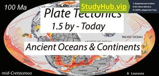
Atlas Of Ancient Oceans And Continents Plate Tectonics During The Last 1.5 Billion Years
•
0 likes•24 views

Paper Writing Service http://StudyHub.vip/Atlas-Of-Ancient-Oceans-And-Continents- 👈

Recommended
More Related Content
Similar to Atlas Of Ancient Oceans And Continents Plate Tectonics During The Last 1.5 Billion Years
Similar to Atlas Of Ancient Oceans And Continents Plate Tectonics During The Last 1.5 Billion Years (20)
More from Sabrina Baloi
More from Sabrina Baloi (20)
Recently uploaded
Recently uploaded (20)
Atlas Of Ancient Oceans And Continents Plate Tectonics During The Last 1.5 Billion Years
- 2. PREFACE This document is not complete. It is a work‐in‐progress. The final version of this technical report will be a chapter in my book, “Earth History: The Evolution of the Earth Systems”. Though this work is incomplete, I thought that it would be worth sharing because there are many diagrams and nuggets of information that a student of earth history might find interesting. You may notice that the format of this report is not in the standard format for scientific papers. This is intentional. I would like this essay to be readable, literate (i.e., sound nice), and uncluttered by jargon and ellipsis. You may notice that the main body of the text has few scientific citations. The only citations are the “must know” citations. A more detailed scholarly discussion, including numerous cited references, will be found in the footnotes. Using the footnotes motivated readers will be able to follow the trail of information that lead me to the summaries and conclusions present in the paper. Though this is a cumbersome approach, I believe that this “hypertext” style will be the ideal format for the final, digital version of my book . The final format of the book will be similar to the linked articles in WikiPedia. The reader will be able to follow interlinked trails of information describing the evolution of the Earth System. I also plan to add links to animations that will illustrate important tectonic events. So think of this as a different kind of blog. A blog about the history of the Earth. . I apologize if the incompleteness of this work is annoying or raises unanswered questions. In this regard, feel free to contact me at cscotese@gmail.com if you have questions, comments or corrections.
- 3. Plate Tectonics during the Last 1.5 billion years: An Atlas of Ancient Oceans and Continents Introduction The maps in this atlas are the first draft of a new set of plate tectonic reconstructions that will provide the framework for the revised paleogeographic and paleoclimatic maps that I am preparing for my book, “Earth History: Evolution of the Earth Systems”1. As the title of this work implies, the goal of this atlas is to identify the major continents and oceans back through time. Tables 1 and 2 list the names of the continents and oceans shown in Figures 4 ‐ 52. Figure 1 is a “plate tectonic phylogeny” that shows how these continents and oceans have developed through time2. Continents Continents are defined to be regions of the Earth that are underlain by continental crust3. Continents may be “emergent” or “flooded” depending on sea level, which has varied from ~200 meters above modern sea level to ~200 meters below modern sea level during the past 600 million years4. The continental regions on these maps are shown in two colors: gray and white. The gray areas represent extant regions of continental crust. The white regions represent areas of continental crust that have been removed by subduction (tectonic erosion) 5, have been underthrust beneath continents (e.g., Greater India) 6, or have been squeezed and compressed into much narrower zones (e.g. the Rocky Mountains or the Central Asian collision zone) 7. Continents come in a variety of sizes and shapes (Table 1). We reserve the name “continent” for regions of continental crust greater than 10 Mkm2 . 7.1 The present‐day continents are: Africa, Antarctica, Asia, Australia, Europe, North America, and South America. In the Early Ordovician the continents were: Baltica, Cathaysia, Laurentia, and Siberia. Regions with areas less than 10 Mkm2, but more than 1 Mkm2 are “subcontinents”. Subcontinents, like the Indian subcontinent (4.6 Mkm2) may be contiguous with a larger continent, but are considered to be a distinct region7.2. India is subcontinent because it is separated from Asia by the Himalaya mountains and Tibetan plateau. Greenland (2.1 Mkm2) and Zealandia (4.9 Mkm2 ) are island subcontinents7.3. Regions of continental crust less than 1 Mkm2 are “microcontinents” (e.g., S. Orkney Islands, Seychelles, Rockall plateau, or Tasman Rise). 7.4 Almost all of the modern microcontinents are islands (Table 1). At the other end of the scale are the “supercontinents” of Pangea, Gondwana, Pannotia, Rodinia, Terra Borealis, and Columbia which have comprised more than 100 Mkm2 of the Earth’s surface (Table 1). The etymology of the names of the continents is summarized in Table 1. With regard to the modern continents, the term “Asia” is one of the most ancient recorded geographic names, whose ultimate provenance is unknown. 8 “Africa” is from the Latin, “afri”, which refers to the lands south of the Mediterranean. 9 The Latin term “Antarctic” means “opposite of the north” (Arctic). Antarctica, was originally known as Terra Australis (Land of the South), but that name was taken by Australia.10 Europe is named after the Greek goddess, “Europa”, a beautiful Phoenician princess. 11 Both North and South America are named after Armerigo Vespucci, a 16th century cartographer. 12
- 4. The best‐known paleocontinents are: Pangea, Gondwana, Laurasia, Pannotia, Rodinia, and Columbia. Pangea12.1 (also Pangaea) meaning “all lands” was the name given by Alfred Wegener12.1a (1912) to describe the supercontinent that broke apart to form the modern continents and ocean basins. The terms Gondwana12.2 (also Gondwana‐Land) and Laurasia were coined by Alex Du Toit in 1937. Laurasia12.3 referred to the northern half of Pangea composed of North America and Eurasia (minus India). Gondwana referred to the southern half of Pangea made up of Africa, Arabia, South America, Madagascar, India, Australia, Zealandia, and Antarctica. During the Precambrian there were four large continents worthy of the nomen, “supercontinent”. The youngest Precambrian supercontinent, Pannotia12.5, was named by Chris Powell in 1995. Pannotia was formed during the Pan‐African Event (600 Ma – 550 Ma) when many of the southern continents collided, assembling Gondwana. The best‐known Precambrian supercontinent, Rodinia12.6, was formed ~1000 Ma during the peak of the Grenville Orogeny. The name, Rodinia12.6, which is derived from a Russian term meaning “to beget”, was coined by Mark and Dianna McMenamin. Rodinia has been called “the mother of all supercontinents”. The oldest Precambrian supercontinent, Columbia12.7, is thought to have formed during the late Paleoproterozoic (~1700 Ma). It was named by John J. Rodgers and Madhava Santosh for the Columbia region of North America, which they thought was a good geological match for parts of India. The derivations of the names of the other ~50 continents and paleocontinents are given in Table 1. Oceans Ocean basins are defined to be regions of the Earth that are underlain by oceanic crust. 13 Ocean basins, together with the flooded portions of the continents, comprise the Earth’s oceans, seas, and seaways. 14 Table 2 lists the oceans illustrated in this Atlas. It is interesting to note that according to the definition of continent and ocean proposed here, there are regions of the Earth that can be considered to be both “continents” and “oceans”. These regions are the portions of the continents flooded by the sea. For example, the Grand Banks of eastern Canada is part of the continent of North America, but the water above the Grand Banks is part of the Atlantic Ocean. This duality is due to the fact that the landward boundary of the ocean is the shoreline, whereas the seaward boundary of the continent lies near the junction of the continental rise and continental slope. 15 In the past, this duality has lead to a fair degree of confusion when it came to naming oceans and continents. Also, it should be noted that no attempt has been made to show past coastlines on the maps in this atlas. 16 The derivation of the names of the modern oceans generally falls into one of three categories: mythological names, location names, and descriptive names. For example, the Atlantic Ocean is named after the Greek god, Atlas17; the Indian Ocean is named after the subcontinent of India; the Pacific Ocean was named by Francisco Pissarro, who thought that the Pacific Ocean looked “peaceful” 18. Some of Paleozoic and Mesozoic Oceans are named after Greek gods related to Atlas. Iapetus was the father of Atlas, and Rhea (Rheic Ocean) was the sister of Iapetus. Tethys was the sister (and wife) of Oceanus. 19 Because it is difficult to meaningfully continue these lineages, none of the new oceans are named after Greek gods. Instead we have adopted a dual naming convention. The names of the new oceans either reflect the local geography (e.g., the Mozambique Ocean once ran through most of East Africa, including Mozambique) or a related geologic/tectonic feature (
- 5. e.g., the Grenville Ocean is the ocean basin that closed during the Grenville Orogeny (~1050 Ma) in eastern North America. Coining new names for every new ocean, however, can be confusing. To avoid confusion and promote clarity we have tried to make slight modifications to existing names, especially if there is a relation of inheritance. For example, originally there was just one ocean called the “Tethys Ocean”. However, we now know that three distinct oceans: ProtoTethys, PaleoTethys, and NeoTethys once existed in the Tethyan realm. Using this format, we have coined the new terms “PaleoPanthalassa” and “ProtoPanthalassa” to described earlier versions of the Panthalassic Ocean. The names of these bodies of water may change slightly depending on the maturity of an ocean basin. A newly formed ocean basin, one that is still relatively narrow, may be called a “sea”, like the Red Sea, or if it connects two larger bodies of water, it may be called a “seaway”. The term “sea” is also used for bodies of water surrounded or partially enclosed by continents, like the Mediterranean Sea or Weddell Sea. Oceans as they age, gradually narrow as the continents on either side of the ocean approach each other (through subduction of oceanic lithosphere). Thus, it is possible for a once mighty “ocean” to become a narrow “sea” or “seaway” prior to its demise. Plate Tectonics Plate boundaries are also shown on these maps, but no attempt has been made to identify the plates (e.g., Pacific, Farallon, Nazca, etc.) or label the individual plate boundaries (e.g., Mid‐ Atlantic Ridge). This will come later. I think that it is important that we have different and distinct names for the continents and oceans, on the one hand, and the plates, which underlie them, on the other hand. For example, it is easy to confuse the “Pacific plate” with the “Pacific ocean”. The Pacific Ocean is currently made up of several plates (the Pacific plate, Nazca plate, and Cocos plate – to name a few); whereas there is only one “Pacific plate”. Like an infuriatingly difficult jigsaw puzzle whose pieces change size and shape as you try to solve it, the continents constantly break apart as new ocean basins form, and then reassemble into new shapes as subduction zones bring them back together. The global plate tectonic model20 that I have built has more than 500 “jigsaw puzzle pieces”. These puzzle pieces are called “tectonic elements” (Table X). 21 Figure XX. Is a modern map with labels for the XX principal tectonic elements shown in this Atlas . Data & Methods The methods used to reconstruct the past positions of the continents and the configuration of the surrounding ocean basins varies, depending on the age of the reconstruction (Figure 2 & 3). As one might suspect, the useful information decreases in both quantity and quality back through time. 22 Ten lines of evidence are used to produce plate tectonic reconstructions: 1) the age of the ocean basins, 2) synthetic isochrons, 3) hot spots and large igneous provinces (LIPS), 4) subduction graveyards, 5) paleomagnetism, 6) true polar wander (TPW), 7) paleobiogeography, 8) paleoclimate, 9) continental geology and tectonics, and 10) the rules of plate tectonics. Age of the Ocean Basins23 (add text) Synthetic Isochrons24 (add text)
- 6. Hot Spots25 & LIPS26 (add text) Subduction Graveyards27 (add text) Paleomagnetism: Paleopoles & Apparent Polar Wander (APW)Paths28 (add text) True Polar Wander29 (add text) Paleobiogeography30 (add text) Paleoclimate31 (add text) Continental Geology & Tectonics32 (add text) The Rules of Plate Tectonics33 (add text) As Figure 2 illustrates, some of these lines of evidence clearly have restricted time ranges. 33 Other lines of investigation provide guidance for the entire time range (e.g. Continental tectonics, paleomagnetism, plate tectonic rules). The vertical width of the color‐coded swaths in Figure 2 are my estimate of the “importance” of each line of evidence back through time35. Confidence in the Maps As one might expect there is greater confidence in the more recent plate tectonic reconstructions that in the plate tectonic reconstructions for older times. In Figure 3, I have tried to quantify these changing levels of confidence. The percentages shown are my estimates of the accuracy of the maps36. To arrive at these percentages, I used the following procedure. 1) I started with the number of lines of evidence used to make each map. Back to ~150 million years all 10 lines of evidence could be used to make a plate tectonic reconstruction (blue line). Between 150 million years and 300 million years the number of lines of evidence drops off sharply, then plateaus. There is a final drop‐off at 540 Ma. For the Precambrian maps, there are only 6 lines of evidence available (Paleoclimate, LIPS, paleomagnetism, TPW, continental tectonics, and the plate tectonic rules). 37 2) Though the number of lines of evidence reflects the confidence level, that must be modify to take into account the decreasing quantity and quality of data back through time. The sloping pink curve takes into account decreasing quantity and quality of information back through time38. 3) In a final adjustment (red curve) the confidence level was further modified to take into account the role that supercontinents play. Simply stated, our confidence in the plate tectonic reconstructions is low when the continents are dispersed and are traveling on numerous plates. When the continents are collected into one supercontinent, or a few large continents, our confidence in the reconstruction is much higher39. In summary (more text) Plate Tectonic History 1.5 Billion ‐ Today The maps in this report have been excerpted from the animation by Scotese and Elling (2017). The full‐length version of this animation can be found at https://www.youtube.com/watch?v=IlnwyAbczog. 40
- 7. This animation focuses of the plate tectonic development of our planet during the last 1.5 billion years. 41 Some highlights42: Mesoproterozoic (1600Ma – 1000 Ma) 1800 – 1500 Ma ‐ the supercontinent “Columbia” breaks up into Grenvillia, Chimeria, and Greater Amazonia. 1500 Ma ‐ An unknown continent rifts away from the southern margin of Chimeria opening the ProtoPanthalassic Ocean; The Cathaysian seaway opens as BundelWAus and Aravarabia rift away from Chimeria; a failed rift between BundelWAus and Aravarabia becomes the Aravalli seaway. 1450 Ma ‐ Dharayner rifts away from Greater Amazonia opening the Mozambique Sea. 1400 – 1200 Ma ‐ subduction of the Bundelkhand ocean along the southwest‐dipping Kalahari‐Aravalli‐Bundelkhand subduction zone; subduction of the Musgrave ocean along the the southeast‐dipping Northern Australian‐Siberian subduction zone; subduction of the ProtoPanthalassic oceanfloor beneath the Amazonian‐West African subduction zone an the Grenvillian subduction zone. 1300 Ma ‐ Subduction begins along the northern margin of the Cathaysian ocean. 1250 – 1200 Ma ‐ The Cathaysian ocean closes as Chimeria collides with BundelWAus and Aravarabia. The Bundelkhand sea closes as Dharayner collides with BundelWAus. The Gamburtsev Sea closes as Grenvillia collides with Dharayner; The Arctida ocean closes as the Gawler craton collides with Northern Australia, and the Mawson craton collides with the BHWI ‐ Bundelkhand craton. These four continent‐continent collisions assemble much of eastern Gondwana and form the supercontinent, “Terra Borealis”. See Figure XX for a south polar view of the collision. 1250 ‐ 1150 Ma ‐ The ProtoPanthalassic midocean ridge is subducted beneath Amazonian and triggering the breakup of Terra Borealis. The Grenville Ocean closes as Greater Amazonia collides with Grenvillia (Grenville Orogeny). 1150 – 1100 Ma ‐ The Congo continent and Balto‐Siberia rift away from Terra Borealis forming the PaleoPanthalassic Sea and the Sea of Hijaz; Arabia and the Kalahari craton rift apart. 1100 – 1000 Ma ‐ The PaleoPanthalasssic Ocean widens at the expense of the ProtoPathalassic Ocean. Neoproterozoic (1000 Ma – 541 Ma) 1000 Ma ‐ Balto‐Siberia collides with Grenvillia forming Rodinia. Congo continent collides with southwest margin of Rodinia. 1000 – 950 Ma ‐ Congo continent rifts away from Amazonia and opens the Pharusian‐Adamaster Ocean and begins to close the Mozambique Sea. Baltica rifts from Siberia opeing the Aegir Sea. 950 – 900 Ma ‐ The southerwestern margin of Lauentia collides with the northeastern margin of Laurentia. 900 – 800 Ma ‐ The Pharusian‐Adamastor ocean widens as the Mozambique Sea narrows. 800 – 700 Ma ‐ Rodinia breaks apart as North Rodinia rifts away from South Rodinia opening the Panthalassic Ocean. The PaleoPanthalassic triple junction is subducted beneath Baltica. 800 – 600 Ma ‐ complex , diachronous closure of the Mozambique seaway.
- 8. 750 Ma ‐ The Pharusian‐Adamastor midocean ridge is subducted beneath the southern margin of the Congo continent. 700 Ma ‐ the opening of the Kipchak Ocean as continental arcs rift away from Siberia 600 Ma ‐ the start of multiple subduction zones along eastern Australia and Antarctica, the north‐facing margin of Siberia (Mongolia & Amuria), and the Cadomian region of northern Gondwana 600 – 580 Ma ‐ the conversion of slow‐spreading ridges in the Kipchak Sea to subduction zones 580 Ma ‐ the opening of the Iapetus Ocean 580 – 520 Ma ‐ 1500 km of dextral strike‐slip motion between Siberia and Laurentia Paleozoic (541 Ma – 252 Ma) 530 Ma ‐ subduction of the Panthalassic midocean ridge beneath the Tasman‐TransAntarctic subduction zone (SZ) 515 Ma ‐ the conversion of the Central Iapetus midocean ridge (MOR) into a subduction zone and the start of the Taconic island arc 510 Ma ‐ subduction of the SW Iapetus MOR beneath the NW Amazonian SZ; and the rifting of the pre‐Cordillera terrrane from the southern margin of Laurentia 500 – 400 Ma ‐ accetion and collision of island arcs in the Kipchak Sea to form core of Kazakhstania 495 Ma ‐ the rifting of Avalonia from Amazonia resulting in the opening of the Rheic Ocean 485 Ma ‐ subduction of the ProtoTethyan MOR beneath the easternmost Kipchak island arc 475 Ma ‐ rifting of the Cathaysian continents (N.China, S. China, Indochina, & Tarim) from the Indo‐Australian margin of Gondwana 465 Ma ‐ collision of the Taconic arc with the eastern margin of Laurentia 455 Ma ‐ westward, Andean‐style subduction begins along the eastern margin of Laurentia; eastward‐dipping subduction begins along the western margin of Laurentia 445 Ma ‐ Avalonia collides along the southern margin of Baltica and subduction begins along the southern margin of Avalonia 440 – 425Ma ‐ 1500 km of sinistral strike‐slip motion between Siberia and Laurentia 425 Ma ‐ Baltica collides with Laurentia (Caledonian orogeny); Rheic MOR is subducted beneath Laurassia (Laurentia & Baltica); opening of Seventy Mile back‐arc basin (BAB) along the western margin of LAurentia 420 Ma ‐ subduction begins along northern margin of Gondwana 400 Ma ‐ collision of southern Laurentia and northern South America (Acadian orogeny); Laurussia, reverses direction and head northward causing the conversion of MOR is the Seventy Mile Sea to convert to a subduction zone; Amuria begins to rotate counter‐clockwise closing the Mongol‐Okhotsk Seaway 370 Ma ‐ initial collision between northern Gondwana (Amorican terranes) and Laurussia 360 Ma ‐ collision of Seventy Mile island arc with western Laurussia (Antler /Caribou orogeny); Tarim collides with southern Kazakhstania (Tien Shan orogeny); northward dipping subduction begins beneath the Cathaysian continents
- 9. (N.China, S. China, Indochina, & Tarim); South China (Yangtze craton) begins to rotate clock‐wise closing the QinLing Ocean 360 – 300 Ma ‐ 1000 km of dextral strike‐slip collision between Armorican terranes of northern Gondwana and Hercynian Europe 300 Ma – closure of Central Asian Oceans (Altaids) and accretion of Kazakhstania between Europe and Siberia (Urals); subduction of PaleoTethyan MOR beneath Kazakhstania and Cathaysia; rifiting of the Cimmerian continent ( Sanandaj‐Sirjan terrane of Iran, Sistan and Farah blocks of Afghanistan, Lhasa, QiangTang, and Sibumasu (Siam, Burma, Malaysia, and Sumatra) from the Indo‐Australian margin of Gondwana; collisionof LAurusssia and Gondwana to form western half of Pangea (Alleghenian/Variscan orogenies); accretion of Chileana and Patagonian terranes of SW Gondwana (Cape orogeny) 260 Ma ‐ collapse of Seventy Mile back arc basin and collision of Sonoma island arc along western North America; accretion of Marie Byrdland and Zealandia to East Antarctica and eastern Australia; Eruption of the Omeishan LIP in SW China; 255 Ma ‐ closure of Solonker Sea between Amurian and North China 250 Ma ‐ eruption of the West Siberia large igneous province (LIP) Mesozoic (252 Ma – 66 Ma) 245 Ma ‐ opening of Cache Creek BAB as Wrangellia rifts away from northwestern South America; opening of Slide Mountain BAB as Stikinia rifts away from northern Mexico 240 Ma ‐ Sibumasu collides with Indochina along Bangong‐ Nujiang Co collision zone 240 – 220‐ Ma ‐ subduction begins along southern margin of Cimmeria (propogating east to west) 220 Ma ‐ closure of QinLing Seaway and accretion of Songpan‐Ganze as South China (Yangtze craton) collides with North China; initial rifiting in Central Atlantic region (Newark group) 200 Ma ‐ eruption of Central Atlantic Magmatic Province (CAMP); PaleoTethyan MOR is subducted beneath Cimmeria; unknown sliver continent rifts away from northern margin of Gondwana; Mongol‐Okhotsk seaway narrows; East Gondwana (Madagascar/India/Australia/Antarctica) begins to rift away from West Gondwana (South America/Africa) 195 Ma ‐ Final closure of Paleotethys as Cimmeria accretes to Eurasia; BAB between QiangTang and Lhasa opens; 190 Ma ‐ the Karoo LIP erupts (Walvis Ridge / Tristan da Cunha hot spot) 185 Ma ‐ the Pacific plate is created at the Izanagi/Phoenix/Farallon triple junction 180 Ma ‐ Seafloor spreading starts in Central Atlantic and proto‐Caribbean , rifting in Gulf of Mexico and the Western and Eastern Mediterranean; sinistral strike‐slip between Mexico and North America; rifting begins in the Canada Basin between the North Slope block and Arctic North America; extension in the southern regions of the North Atlantic (between North America & Greenland, between Greenland – Rockall); subduction begins along eastern margin of Asia (Yenshanian orogeny) 180 – 100Ma ‐ Wrangellia moves ~3000 km northward closing Cache Creek BAB 175 Ma ‐ spreading ridge in Slide Mountain BAB converts to subduction zone as North America is driven westwards;
- 10. 170 Ma ‐ Seafloor spreading between East and West Gondwana; seafloor spreading between Iberia and North America; 165 Ma ‐ Caribbean (B’’) oceanic crust is created near Izanagi/Phoenix/Farallon triple junction 160 Ma ‐ NeoTethyan MOR is subducted beneath Eurasia; Izanagi MOR connects with new MOR north of Exmouth plateau as 150 Ma ‐ Rifting in South Atlantic; Stikine terranes collide with North America closing the Slide Mountain BAB; Lhasa‐ Qiangtang BAB closes 150 – Today ‐ North America moves westward and the Rocky Mts are thrust skyward (Sierra Nevada, Sevier and Laramide orogenies) 145 Ma ‐ Gulf of Mexico stops opening 140 Ma ‐ Seafloor spreading begins in southern South Atlantic 135 Ma ‐ Eruption of the Etendeka (Namibia)‐Serra Gerral (SE Brazil) LIPs 120 Ma _ Rifting in east‐central Africa (Chad / Sudan); complete closure of the Mongol‐Okhotsk Seaway; 120 ‐90Ma ‐ Eruption of large LIPs in the SW Pacific (Manihiki, Ontong‐Java) 115 – 90 Ma ‐ Creation of the Kerguelen plateau by voluminous reruptiosn at the Kerguelen hot spot (HS) 115 – 75Ma ‐ Opening of the Olyutorska BAB of NE Siberia 110 Ma ‐ Seafloor spreading begins in the northern South Atlantic; the Philippines island arc rifts away from the margin of S. China; 100 Ma ‐ Wrangellia collides with western North America (British Columbia); collision of Caribbean oceanfloor with Mid‐ America SZ results in “capture” of Caribbean and start of west‐ dipping SZ along the eastern margin of the Caribbean plate; Rifitiing in the Tasman Sea as Zealandia begins to separate from eastern Australia; 105 Ma ‐ Seafloor spreading stops in the Somali Basin and between NW India and the Lut block; 100 – 50 Ma ‐ Dextral strike‐slip along western North America carries Wrangellia and portions of the Stikine terranes, northward (~1500 km). 95 – 50 Ma ‐ Australia slowly rifts away from Antarctica 90 Ma ‐ India rifts away from Madagascar opening the Madagascar basin 90 – Today ‐ Sinistral strike‐slip along the northern margin of South America as Caribbean plate moves eastward along transpressive boundary; creation of the Ninety East Ridge by the Kerguelen HS 80 Ma ‐ Obduction of ophiolites in Guatemala and Honduras as Caribbean plate collides with Central America 85 – 70 Ma ‐ The oceanic lithosphere of the Bering Sea is created at the Izanagi MOR 75 ‐ 35Ma ‐ Sea Floor Spreading in the Philippine Sea 65 Ma ‐ India, as it moves northward, collides with Lut block and carries it northward towards Eurasia; Eruption of the Deccan LIP; Cenozoic (66Ma – Modern) 60 Ma ‐ Subduction of the Izanagi MOR beneath eastern Asia; Subduction of the NE Indian Ocean MOR north of Australia;
- 11. Collision of the island arcs that makeup Kamchatka with NE Siberia; Capture of the Sea of Okhotsk; 60 Ma – Today ‐ Collision of Adria/Apulia to form the Alps; 55 Ma ‐ The Pacific plate changes direction (from N to W‐NW); 50 Ma ‐ India begins to collide with Asia; Greater Antilles arc (Cuba & Hispaniola) collides with Bahamas platform opening the Yucatan basin; Caribbean plate begins to move eastward with spreading at Cayman Ridge; 50 ‐ 25Ma ‐ Sea floor spreading in the Caroline Sea 50 Ma – Today ‐ The collision of India deforms south‐central Asia and results in the southeastward “extrusion’ of SE Asia; Australia, together with India, rapidly rifts away from Antarctica 45 Ma ‐ Extension begins in South China Sea 35 Ma ‐ Extension begins in East Africa and Red Sea/Gulf of Aden; 30 Ma ‐ Youngest ocean floor in South China Sea and Sea of Japan; closure of the deep marine connection between Tethys and the eastern Mediterranean; 30 – 15 Ma ‐ Cosica and Sardinia rifts away from the southern coast of France opening the Ligurian Sea , and the Balearic islands rift away from the eastern coast of Spain opening the Balearic Sea (due to slab roll‐back); 30 Ma – Today ‐ Extension begins in the Basin and Range; Collision of Arabia and Ian to form the Zagros Mts.; 25 Ma ‐ Subduction of the Farallon MOR beneath northern Mexico/southernmost California resulting in the rifting of Baja California from northwestern Mexico; 25 Ma – Today ‐ Baja California and California west of the San Andreas Fault are carried northwestwards with the Pacific plate; continuing extension in the Basin & Range 20 Ma ‐ Seafloor spreading (oldest ocean floor) in the Gulf of Aden; 15 – 0 Ma ‐ Calabria rifts away from Sardinia opening the Tyrrhenian Sea (due to slab roll‐back); ~500 km of dextral motion along the North Anatolian Fault as Turkey is squeezed westwards between Arabia and Eurasia; 10 Ma – Today ‐ The extension in the Aegean Sea; ~150 km sinistral displacement along the Dead Sea Fault ; Addenda Abbreviations Used: HS – hot spot (i.e. the surface expression of a mantle plume) MOR ‐ Midocean Ridge SZ ‐ Subduction Zone BAB ‐ Back‐arc Basin LIP ‐ Large Igneous Province Some Definitions: Continent – a large, (>10Mkm2) mostly emergent landmass foundered on continental lithosphere.
- 12. Subcontinent – a medium‐sized, (<10Mkm2 ‐ > 1Mkm2 ) landmass foundered on continental lithosphere. Microcontinent – a small (> 1Mkm2 ) region, usually an island, foundered on continental lithosphere. Ocean – a large, deep (> 2500 m) ocean basin foundered on oceanic lithosphere Sea – a medium‐sized oceanic region that is partially enclosed or entirely by continents Seaway – a narrow oceanic region that is connected to open ocean, but is largely surrounded by continents. Plate – A region of lithosphere bounded by one or more of the following tectonic boundaries: midocean ridge (MOR), subduction zone (SZ), or strike‐slip fault (transform or transcurrent). Terrane – a lithospheric region bounded by indentifiable tectonic boundaries that possesses a coherent stratigraphic record. Block – A small region lithosphere, usually continental, that is bounded by unspecified tectonic boundaries. Tectonic Element – A plate, terrane, or block that has had a unique history of independent movement. Credits These plate tectonic reconstructions and animations are based on the PALEOMAP Global Plate Tectonic Model. developed by C.R. Scotese. The were visualized using the program, Gplates, developed by R.D. Müller and EarthByte team . (insert Gplates logo) References Cited (to be added later) Appendices Appendix A. Plate Tectonic Tree Diagram Appendix B. Table of Contents for “Earth History: Evolution of the Earth System”
- 13. Name of Continent , Subcontinent, or Microcontinent Etymology Area Mkm2 Age Range (Ma) Citation Supercontinents Pangea* (Mesozoic) 224 ‐ 190 Pangea* (Paleozoic) 300 ‐ Laurasia 113 190 ‐ 100 Gondwana** 111 550 – 190 Pannotia 650 ‐ 550 North Rodinia 800 ‐ 650 South Rodinia 800 ‐ 650 Rodinia 1000 ‐ 800 Terra Borealis 1250 ‐ 1150 Columbia 1800 ‐1600 Continents Africa 36.7 140 ‐ 0 Asia 61.7 50 ‐ 0 East Antarctica 13.5 90 ‐ 0 Australia 14.8 90 ‐ 0 Europe 13.5 300 ‐ 0 North America 41.0 190 ‐ 0 South America 24.4 140 ‐ 0 West Gondwana 190 ‐ 140 East Gondwana 190 ‐ 90 Laurussia 420 ‐ 300 Laurentia 580 ‐ 420 Baltica 580 ‐ 420 Siberia 600 ‐ 300 Cimmeria 300 ‐ 190
- 14. Cathaysia 480 ‐ 260 ProtoRodinia Congo Continent BaltoSiberia Greater Amazonia Grenvillia Chimeria This report Subcontinents This report India 4.6 This report Greater India ~7.5 This report Zealandia 4.9 This report Arabia This report West Antarctica‐Marie Byrdland 5.8 This report Greenland 2.1 Amuria North China South China Kazakhstania Armorica Avalonia Hijaz Kalahari craton BundelWAus Aravarabia Dharayner Microcontinents Madagascar Wrangellia
- 15. Stikine This report Yucatan This report Lut This report Turkey Chortis Adria 0.6 Iberia Omolon Indochina Borneo Tarim Chileana Cuyania * also Pangaea, ** also Gondwana‐Land
- 16. TABLE 1. Oceans Name of Ocean, Sea, or Seaway Etymology Age Range Citation Atlantic Greek god, Atlas 130 – 170 Ma North Atlantic Greek god, Atlas 0 – 130 Ma South Atlantic Greek god, Atlas 0 – 130 Ma Indian India 0 – 130 Ma Southwest Indian SW portion of Indian Ocean Southeast Indian SE portion of Indian Ocean Pacific “pacifico” meaning peaceful 0 – 170 Ma Arctic 0 ‐ 150 Ma Mediterranean Red seasonal blooms of the red‐ coloured Trichodesmium erythraeum Strabo, c. 64 BCE Ligurian Black Because it was “inhospitable”; Pontus Axeinus Strabo, c. 64 BCE Caspian Tyrhennian Aegean Balearic Balearic islands Bering Arctic explorer, Labrador Territory of Labrador Weddell Antarctic explorer, Ross Antarctic explorer, Tasman Somali country of Somalia Mozambique country of Mozambique dual Scotia Caribbean ProtoCaribbean “first Caribbean” Gulf of Mexico* country of Mexico Philippine country of the Philippines South China country of China Banda island of Banda Japan island of Japan Okhotsk NeoTethys Greek god, PaleoTethys Greek god, ProtoTethys Greek god, Cache Creek regional geology Slide Mountain regional geology
- 17. Seventy Mile regional geology Mongol‐Okhotsk After Mongolia & Sea of Okhotsk Angayuchim Innuit term meaning X Kipchak Uralian Ural mountains This report Sverdrup Arctic explorer This report Iapetus Greek god, Rheic Greek god, Aegir Greek god, Panthalassic Greek meaning “global ocean” A. Wegener PaleoPanthalassic meaning “ancient Panthalassa” This report ProtoPanthalassic Meaning “first Panthalassa” This report Pharusian‐ Adamastor Hijaz Arctida Arctic Zonenshain Musgrave regional geology This report Cathaysian archaic word for China This report Aravalli regional geology This report Bundelkhand regional geology, Bundelkhand craton This report Gamburtsev Gamburtsev mountains This report Grenville regional geology, Grenville Font This report * also Neo‐Tethys, Neotethys,
- 18. Figure Captions Figure 1. Plate Tectonic Phylogeny This figure illustrates how continents have come together through time to form supercontinents (PANGEA, PANNOTIA, RODINIA, TERRA BOREALIS, & COLUMBIA), and how these supercontinents have broken apart to form new oceans and sea (blue lettering). The vertical axis is the timescale of Gradstein et al. (2012). ARB = Arabia, AFR = Africa, ANT = Antartica, AUS = Australia, BAJ = Baja California, CAR = Caribbean islands, EUR = Eurasia, Jp = Japan, Nq = Neuquen terrane, SAM = South America, SC = Scotia arc, 1A. Origin of the Earth (4.6 Ba) to the base of Cambrian Period (541 Ma) 1B. Mesoproterozoic (1400 Ma) to the top of the Triassic (201 Ma) 1C. Middle Triassic (237 Ma) to the Recent. Figure 2. Data and Methods This diagram highlights the ten lines of evidence that are used to make plate tectonic reconstructions. The vertical width of each swath represents the relative importance of that line of evidence at each age. Figure 3. Confidence Levels The confidence levels are semi‐quantitative estimate of the accuracy of the plate tectonic reconstructions. Accuracy improves when the continents are gathered together in supercontinents (Mesozoic Pangea, Paleozoic Pangea, Pannotia, Rodinia, Terra Borealis, and Columbia). Events: a = collision of India (50 Ma), b = marine connection between Central and South Atlantic (100 Ma), c = Permo‐Triassic extinction (250 Ma), d = start of Permo‐Carboniferous Ice House (350 Ma), e = well‐ defined Ordovician faunal realms (460 Ma), f = Cambrian Explosion (540 Ma) , g = Snowball Earth (635 Ma), h = Breakup of Rodinia (800 Ma), i = Breakup of Terra Borealis (1150), j = Breakup of Columbia. Figure 4.
- 19. Footnotes Note:. The footnotes will be renumbered in a simple, consecutive style once the text in finished. 1 More about book. 2 What phylogeny shows. Source: Scotese (1990?, 1999?, 2004) 3 Continental crust is the uppermost layer of the continental lithosphere. More & figure. 4 What is meant by sea level. Problems in defining sea level. How ancient sea level is measured. Examples of published sea level curves. 5 Discussion tectonic erosion 6 Definition of Greater India. Evidence for subduction of Greater India. Figures & animation 7 Estimates of convergence in various mountain belts. Inverse “beta factor” 7.1 Definition of what is a continent. Rational. Sources. Figures from Cogley(1984) & Mortimer et al. (2017). 7.2 Definition of a subcontinent. 7.3 More about Zealandia controversy. 7.4 Definition of a microcontinent. 8 More on etymology of “Asia” 9 More on etymology of “Africa” 10 More on etymology of “Asia” 11 More on etymology of “Antarctica and Australia” 12 More on etymology of “North America and South America” 12.1 More on etymology of Pangea 12.1a Some discussion of Alfred Wegener 12.2 More on etymology of Gondwana 12.3 More on etymology of Laurasia 12.4 12.5 More on etymology of Pannotia 12.6 More on etymology of Rodinia
- 20. 12.7 More on etymology of Columbia 13 Discussion of oceanic crust versus oceanic lithosphere, with diagrams. 14 Other names for oceanic and continental bodies of water. 15 Discussion of “continent‐ocean boundary” or COB. Map of modern COBs. 16 Introduce the term paleogeographic map and provide example map. Cite Atlas of Continental Flooding. Introduce hyposometry and hypsographic maps. Relationship between continental flooding, topography, and sea level. All of this can be reused in chapter on Paleogeography. 17 Etymology of Atlantic Ocean 18 Etymology of Pacific Ocean 19 Etymology of Tethys, Iapetus, and Rheic Oceans. 20 Discussion of what a “Global Plate Tectonic Model” is. 21 Definition, description, and discussion of tectonic elements. 22 Some discussion of the reliability of the geologic record 23 Elaboration on Age of Ocean basins and tectonic fabric of the ocean floor 24 How synthetic isochrons are produced 25 Elaboration on hot spots 26 Elaboration on LIPS 27 Elaboration on subduction zone graveyards 28 Elaboration on paleopoles and APW paths 29 Elaboration on TPW 30 Elaboration on paleobiogeography 31 Elaboration on Paleoclimate 32 Elaboration on Continental Geology & Tectonics 33 Elaboration on the Rules of Plate Tectonics 34 For example the modern ocean basins were all formed in the last 180 million years. Deep mantle subduction graveyards can be mapped back to ~250 million years, at best. Fossil evidence relies heavily on the preservation of animals with hard parts (~540 Ma). 35 Additional discussion of Figure 2. What I mean by “importance”. 36 Discussion of confidence level % 37 Discussion of step 1
- 21. 38 Discussion of step 2 39 Discussion of step 3 40 Discussion of this animation an other aniamtions on YouTube. 41 Why back to 1.5 by? 42 Each of these highlights has a footnote (43 – 142) describing and documenting the tectonic event in more detail. Addition discussion will be found in the chapters describing the chronological evolution of the Earth System (Volume 2, Chapters 1 ‐ 13; Volume 3, Chapters 14 ‐ 26). See Table of Contents (Appendix B). 43 – 142 to be added later