The Blob, El Nino and the Drought in Puget Sound
•
2 likes•774 views

The document summarizes conditions in Puget Sound related to warm water anomalies, drought, and impacts on marine ecosystems. It notes that 2014 and early 2015 saw the warmest temperatures since 1981 due to a warm water blob in the Pacific. This, combined with low snowpack due to drought, led to record low river flows into Puget Sound. The warm water entered Puget Sound in late 2014 and 2015, bringing higher temperatures and lower oxygen levels. Observations from aerial photos and ferries detected large jellyfish blooms and algal blooms, indicating the marine food web may be changing.

Recommended
More Related Content
What's hot
What's hot (18)
Viewers also liked
Viewers also liked (20)
Similar to The Blob, El Nino and the Drought in Puget Sound
Similar to The Blob, El Nino and the Drought in Puget Sound (20)
More from Nisqually River Council
More from Nisqually River Council (20)
Recently uploaded
Recently uploaded (20)
The Blob, El Nino and the Drought in Puget Sound
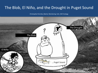
- 1. The Blob, El Niño, and the Drought in Puget Sound ChristopherKrembs,Marine Monitoring Unit, EAP, Ecology The Blob The Drought El Niño
- 2. Warmest first four months since 1981, (Source: NASA's Goddard Institute for Space)
- 3. The snow has melted early or came down as rain Hurricane Ridge: winter snow is gone. Lowsnow has only occurred twice since 1960 (1977 & 2005). April 2010 Feb2013 March2015 Photo by Bill Baccus, Olympic National Park June 2015
- 4. Puget Sound Basin >30% of expected Snow Water Equivalence
- 5. • Mostrivers and streams are at or below 10thpercentile in greater PugetSound Basin • Severalwestern regions are experiencing record low flows By June 1, 2015,most rivers and streamsare at or below 10thpercentile Many rivers and streams are much below normal
- 6. Record low-flows of some Puget Sound rivers (USGS) SnoqualmieRiver Flow only 25% of normal Puyallup River 6/4/ dailymean flow levels belowthe regulatoryminimum 2014 2015
- 7. The Fraser River has been running very high. The “freshet” is much earlier in 2015 Higher thannormal Lower thannormal Expected FraserRiver is the largest freshwatersource of Salish Sea affecting estuarine circulation
- 9. The Blob + El Niño invadesPacific, flummoxing climate experts 2013-2015 Sea SurfaceTemperature(SST)anomaly,29 January2014 Oneweek mean sea surfacetemperature anomaly8-14March2015. Sea Surface Anomalies Persistentmassof warm wateraffects: •oceancurrents, •marineecosystems •inlandweather
- 10. The “Blob” in 2014, (NOAA)
- 11. The Blob hits Washington shores! Timing of coastal winds is important! YEAR JAN FEB MAR APR MAY JUN JUL AUG SEP OCT NOV DEC 2014 -17 -72 -34 -14 2 24 34 35 -1 -62 -49 -88 2015 -49 -27 -18 Upwelling index (NOAA)
- 12. Until September 2014 upwelled water keeps warm water offshore Coastal Upwelling Rain-fed riversSnow-fedriversUpwelling Downwelling Estuarinecirculation Tidalexchange Victoria Seattle snowpack spring-neap cycle tidal mixing over the sillestuarine circulation Fraser Skagit SanJuan Islands Straitof Juan de Fuca Admiralty R. PugetSound upwelled water low DO , high nutrients
- 13. After September 2014 downwelling starts and brings in warm water Downwelling Rain-fed riversSnow-fedriversUpwelling Downwelling Estuarinecirculation Tidalexchange Victoria Seattle snowpack spring-neap cycle tidal mixing over the sillestuarine circulation Fraser Skagit SanJuan Islands Straitof Juan de Fuca Admiralty R. PugetSound downwelled warmer, lower nutrients, lower salinity, LOWER DO
- 14. Ecology’s Marine Monitoring Stations Sampled by a “great team” to full depth every month ChristopherKrembs SkipAlbertson Laura Friedenberg Julia Bos Carol Maloy Mya Keyzers SuzanPool Brooke McIntyre Julianne Ruffner
- 15. Conditions weredominated by warm water associated with the NE Pacific Ocean warmsurfaceanomaly. Starting in October, temperatures are the higheston our record since 1989. Oxygen and salinities are becoming lower. Apr. 2015: Higher Temperature! LowerOxygenLowerSalinity Redboxes show that the water measuredis warmer than any of our measurements since 1989. Eyes Over Puget Sound Marine Long-TermMonitoring Program
- 16. Warm low DO water enters Puget Sound Central Sound Stations 1999-2013 Central Sound last 12 months… Temperatureand Salinity define Density (Density-1000=Sigma)
- 17. Warm low DO water enters Puget Sound Central Sound Stations 1999-2013 Central Sound last 12 months… Temperatureand Salinity define Density (Density-1000=Sigma)
- 18. Ferry monitoring observations 6-8-2015 Surface water (3m) in places already >15°C TheVictoria Clipper IV carries sensors in its sea chest. The sensors allow us to get surfacetransects of temperature, chlorophyll, salinity, and other bio-optical measurements between Seattle and Victoria, BC twice per day. Pockets of sea surfacetemperatures arenow reaching >15°C near Kingston. Temperaturearefavorablefor harmfulalgae species to bloom. In temporalcontext:In spatial context:
- 19. What will the summer of 2015 bring?
- 20. The “Blob” is still offshore! (NOAA) 2014 May2015 June 2015 Blobis ~500 kmoffshore
- 21. Will upwelled water in 2015 stay offshore? Coastal Upwelling Rain-fed riversSnow-fed riversUpwelling Downwelling Estuarinecirculation Tidalexchange Victoria SeattleFraser Rivers spring-neap cycle tidal mixing over the sillestuarine circulation SanJuan Islands reducedsnowpack
- 22. Will an El Niño deepen the nutrient rich water? Coastal Upwelling Rain-fed riversSnow-fed riversUpwelling Downwelling Estuarinecirculation Tidalexchange Victoria Seattle reducedsnowpack Fraser Rivers spring-neap cycle tidal mixing over the sillestuarine circulation SanJuan Islands dense watertoo deep
- 23. Rivers Will summer squalls import more warm water? Downwelling Rain-fedriversSnow-fed riversUpwelling Downwelling Estuarinecirculation Tidalexchange Victoria Seattle reducedsnowpack Fraser spring-neap cycle tidal mixing over the sillestuarine circulation SanJuan Islands
- 24. Speculating about the summer 2015 • No matter in what direction the coastal wind will blow,we can expecta reduced renewalof water in Puget Sound. • PugetSound water will stay warm leading to potentially more regional water quality issues. • Will the situation becomebigger with El Niño? • Expectvery differentgrowth conditionsfor marinespecies.
- 25. The marine food web is responding (the news is coming in…) • Energy-rich northern zooplankton species were replaced by southern copepods at end of 2014. Peter Chandler (Canada),San Diego meeting “The Blob”, May 2015) • Much more gelatinous zooplankton, 'Crunchies' vs. 'Squishies‘, (John Dower,UVIC, CBC NES 6/8 here). • A record high 96% diversion of returning Fraser River sockey salmon via northern Vancouver Island (LaPointe et al. 2015 report, in prep). • Largest toxic algae bloom stretching from Central California to British Columbia. NOAA (Seattle Times 6/16 here). • Firsttime PSP, DSP and domoic acid in Washington at the same time. DOH (Seattle Times 6/16 here).
- 26. Leveraging our flight time • Empty transit flights Seattle - Olympia with camera on board • Document blooms, debris, animal aggregations, oil sheens, water boundaries • Unique perspective, minimal extra cost
- 27. jellyfish jellyfish boat A. B. Large patches of jellyfishforming in finger inlets of South Sound. Location: A.Eld Inlet; B. Budd Inlet on 6-4-2015 (South Sound). 1 Aerial photography 6-8-2015 Navigate Fieldlog Climate Water column Aerial photos Ferry monitoring Streams jellyfish jellyfish jellyfish jellyfishjellyfish jellyfish jellyfish Bloom 2:22PM(6-4-2015)3:11PM
- 28. A. B. 4 Navigate Fieldlog Climate Water column Aerial photos Ferry monitoring Streams Aerial photography 6-8-2015 Large ribbons and patches of organic debris in many places of South Sound. Location: A.North of McNeil Island,B. NisquallyReach (South Sound),3:16 PM. Debris Debris Debris
- 29. Sediment plume of Puyallup River with internal waves meandering into Bay and mixing with a bloom. Location: Commencement Bay(Central Sound),3:28PM. 8 NavigateAerial photography 6-8-2015 Fieldlog Climate Water column Aerial photos Ferry monitoring Streams Bloom boat Plume Internalwaves
- 30. Large Noctiluca bloom surfacing and gathering in large quantities at tidal front. Location: Commencement Bay(Central Sound),3:32PM. 6 NavigateAerial photography 6-8-2015 Fieldlog Climate Water column Aerial photos Ferry monitoring Streams Bloom Debris boat ship
- 31. 10 NavigateAerial photography 6-8-2015 Large Noctiluca bloom held back front off Maury Island Marine Park and Saltwater State Park. Location: East ofVashon Island (Central Sound),3:32PM. Fieldlog Climate Water column Aerial photos Ferry monitoring Streams Bloom Debris
- 32. 15 Navigate Fieldlog Climate Water column Aerial photos Ferry monitoring Streams Large Noctiluca bloom has surfaced near northeast Bainbridge Island across Discovery Park, Seattle. Location: Bainbridge Island(CentralSound),3:45PM. Aerial photography 6-8-2015 boat Debris
- 33. Noctiluca bloom starting to surface and getting washed onto beaches. Location: Port Madison (Central Sound),3:47PM. 18 Navigate Fieldlog Climate Water column Aerial photos Ferry monitoring Streams Aerial photography 6-8-2015 boat barge Debris Debris Debris
- 34. Is the food web changing in Puget Sound? Hypothesis! Is Noctiluca a visible harbingerof a food web change? Hypothesis for combining a series of recent observations affecting energy and material transfer to higher trophic levels
- 35. Eyes Over Puget Sound: