SlideShare a Scribd company logo
1 of 44
Download to read offline
November 17, 2014
Surface Conditions Report
Eyes Over Puget Sound
Fieldlog Climate Water column Aerial photos Ferry andSatellite Moorings
Publication No. 14-03-079
Start here
Up-to-date observations of visiblewater quality conditions in Puget Sound and the Strait of Juan de Fuca
Personalfieldlog p.3
Meet our BEACH program.
Climateconditions p.5
Arecent coldspell affects the Puget Soundlowlands, softening
an8-monthtrendof warmer temperatures. The oceanremains
warm.
Watercolumn p.6
Puget Sound is a lot warmer at the end of 2014 with new max
temps observedthroughout the Sound! Salinity and dissolved
oxygenare mostly expected. The higher DO andcold
temperature anomaly inHoodCanal is disappearing.
Moorings p.40
Water temperature is coolingandthis accompanies reduced
river flows of the past week.
Aerialphotography p.10
Abundant patches of jellyfishseenin finger inlets of South
Sound. Red-brownblooms remainstronginsmaller bays of
SouthSoundcoincidingwith jellyfish. Suspended sediment
increasingly visible as a result of increasedrain, wind, andwaves.
Ferryand satellite p.35
Coldwater fromWhidbey Basinmoves into Puget Sound at the
Triple Junction; associatedwithmoderate levels chlorophyll
fluorescence. Increasedturbidity seenthroughout the Strait of
Georgia.
LONG-TERMMARINEMONITORINGUNIT
Mya Keyzers
Laura Hermanson
Joe Leatherman
Skip Albertson
Dr. Christopher
Krembs
Guest:
Dr. Brandon
Sackmann,
Integral
Julia Bos
Suzan Pool
Editorial assistanceprovided by: Suzan Pool, CarolMaloy, Laura Hermanson
Marine conditionsfrom 11-17-2014 at a glance
Fieldlog Climate Water column Aerial photos Ferry andSatellite Moorings
Please give us feedback
The BEACHProgram helps to reduce the risk of disease for people who playin saltwater by:
What is the Washington BEACH Program?
Notifyingusers when
bacteria results are high.
Educatingthe public about risks
associatedwithpollutionandwhat
we cando to reduce the risks.
Contactwith fecal bacteria contaminated waters can result in gastroenteritis, skin rashes, upper
respiratory infections, and other illnesses. The Washington BEACH Programis led jointly by the
Washington StateDepartment of Ecology and Department of Health. Our BEACH partners include
county and local health jurisdictions, Tribes, and volunteers.
Monitoringbacteria levels
at popular, high risk beaches.
The BEACH program 11-17-2014
Fieldlog Climate Water column Aerial photos Ferry andSatellite Moorings
Keeping Washington beaches healthy -- we're all in this together!
Stay updatedabout water quality at your beaches by keeping up withus on:
Fecal Matters Blog: http://ecologywa.blogspot.com/search/label/Fecal%20matters
Facebook:https://www.facebook.com/WABEACH
Twitter: https://twitter.com/ecologywa
Findpublic beaches and info onbeachclosures:
https://fortress.wa.gov/ecy/coastalatlas/
Personal Field Impression
Fieldlog Weather Water column Aerial photos Ferry andSatellite Moorings
The BEACH program11-17-2014
Fieldlog Climate Water column Aerial photos Ferry andSatellite Moorings
Climateand natural influencesbefore 11-17-2014
Summary:
Air temperatures continue an 8-
month trend, though a recent cold
period introduces cold dense air into
the Puget Sound lowlands.
Precipitation levels have been
above normal, but nil during the past
week as temperatures dropped.
Cloud Cover has been near normal.
River flows are beginning to climb
above normal across the region.
PDO remains in the warm phase,
and upwelling is below normal.
lowerhigher expected No data
New section! Climate and natural influences are conditions that influence our marine waters,
including weather, rivers, and the adjacent ocean (previously called Weather). For an explanation of
the figure, see: http://www.ecy.wa.gov/programs/eap/mar_wat/weather.html, page 26.
We usea chartered float
plane to access our
monthly monitoring
stations.
We communicate data and
environmentalmarine
conditions using:
1. MarineWater
ConditionIndex
(MWCI)
2. EyesOverPuget
Sound (EOPS)
3. Anomaliesand
sourcedata
Fieldlog Weather Water column Aerial photos Ferry andSatellite Moorings
Ourlong-termmarinemonitoringstationsinWashington
Starthere
Isl.
.
Physical conditionstracked in statistically historic context
Fieldlog Weather Water column Aerial photos Ferry andSatellite Moorings
Salinity lower at Coast Oxygen expectedOct. 2014: Temperature – New Max!
PugetSound is a lot warmer at the end of 2014 with new max temps observed throughoutthe Sound! Early 2014
started colder and saltier with lower oxygen, then became fresher and warmer. Salinity is within expected ranges
and dissolved oxygen arevariable throughoutthe regions. The higher DO anomaly in Hood Canal is disappearing.
Redboxesshow
thatthe water
measuredin
Octoberis warmer
thanany of our
measurements
since 1999
Explore profiles
atall stations
a) PacificDecadalOscillationIndex(PDO,temperature) (explanation)
b) UpwellingIndex(anomalies)(Upwelling,lowoxygen) (explanation)
c) NorthPacificGyreOscillationIndex(NPGO,productivity) (explanation)
NPGO(x10)
PDO/UpwellingIndex
Three-year running average of PDO, Upwelling, and NPGO indices scores
Ocean boundaryconditions have been favorable for water qualityin Puget Sound: (a)colder water (PDO),
(b)less upwelled lowoxygen and high nutrient ocean water reachingPuget Sound (UpwellingIndex),and
(c) higher surface productivityalongthe coast (NPGO). Where are we headingnext?
Fieldlog Weather Water column Aerial photos Ferry andSatellite Moorings
.
Theoceanaffectswaterquality: OceanClimateIndices
-25
-20
-15
-10
-5
0
5
10
15
20
25
-1.5
-1
-0.5
0
0.5
1
1.5
1945 1950 1955 1960 1965 1970 1975 1980 1985 1990 1995 2000 2005 2010 2015
Is the food web changing in Puget Sound?
Follow the experts
WebEx
Hypothesis!
Increasesin
nitrate
concentrations
couldbe caused
by a top-down
controlon
phytoplankton
biomass.
Noctiluca
a visible
harbingerof a
food web
change?
Hypothesis for combining a series of recent observations
affecting energy and material transfer to higher trophic levels
Arechangesin highertropic levelspart of a story of the low food web?
Summary: Aerial photography11-17-2014
Abundantpatches of jellyfish seen in finger inlets of South Sound. Red-brown blooms remain
strong in smaller bays of South Sound and coincide with jellyfish. A localized bloom seen off
Tokeland. Suspended sediment increasingly visible as a result of increased rain, wind, and
waves.
Fieldlog Weather Water column Aerial photos Ferry andSatellite Moorings
Start here
Mixing andFronts:
Developed tidal fronts and mixing visible by colored surface
water. Very pronounced in Grays Harbor.
Debris:
Organic debris and foamforming in patches near mudflats,
river plumes, and tidal fronts as a resultof stronger winds and
higher river flows.
Visible blooms:
Red-brown: Southern finger inlets of South Sound and very
localized near Kindred Island, Willapa Bay.
Jellyfish:
Jellyfish patches very numerous in southern inlets of South
Sound (Totten, Eld, and Budd Inlets).
BloomDebrisFront
Suspendedsediment:
As a result of recent precipitation, many river influenced areas
show largesediment plumes. Strong winds, tidal currents, and
dredging affectsediment re-suspension regionally and locally.
Plume
Beautiful NiaviakumRiver, Willapa Bay
Mudflats near SmithCreek, Willapa Bay
1 2 2019
5 7 8 9 10 12
4 5 6 8 9 10 13 14 15 17
1 2 12 17 2019
2 3 5 7 10 11 12 13 14 17 2018
GraysHarbor
Willapa Bay
Fieldlog Climate Water column Aerial photos Ferry andSatellite Moorings
Observation Maps:
Afternoonflight,photos 13-20:
Sunny,cold,winds increasing
Flight Information:
Morningflight,photos 1-12
Sunny,cold,high visibility
8
11
10
15
Aerial photography
and navigation guide20
6
Coast
SouthSound
SeattleTides:H.tide:1:15AM12:58PM,,L.tide:6:29AM,8:00PM
7
12
5
Flight route and fuelingstop
17
9
18
3
2
1
4
13
14
19
16
Numerous jellyfishsmacks with underlying red-brown bloom.
Location: OffLittle Tykle Cove, Budd Inlet (South Sound),9:25 AM.
1 Aerial photography 11-17-2014 Navigate
Fieldlog Climate Water column Aerial photos Ferry andSatellite Moorings
Bloom
jellyfish
jellyfish
jellyfish
jellyfish
jellyfish
jellyfish
jellyfish
jellyfish
jellyfish
A.
B. C.
2 NavigateAerial photography 11-17-2014
Fieldlog Climate Water column Aerial photos Ferry andSatellite Moorings
Red-brown bloom, organic debris, jellyfishsmacks, and edge of river plume with internal waves.
Location: A.FlapjackPoint,B. Shell Point,C. Snyder Cove, Eld Inlet (South Sound).
Debris
Bloom
Bloom
boat
internal waves
9:27AM 9:27AM
1:31PM
jellyfish jellyfish
jellyfish
Debris
boat
Bloom
3 NavigateAerial photography 11-17-2014
Long organic debris line in Chehalis River.
Location: Cosmopolis (Grays Harbor),9:51AM.
Fieldlog Climate Water column Aerial photos Ferry andSatellite Moorings
Debris
4 Navigate
Fieldlog Climate Water column Aerial photos Ferry andSatellite Moorings
Aerial photography 11-17-2014
Sediment-richriver plume hugging the southern shoreline of Grays Harbor and Chehalis River water.
Location: OffStafford Creek(Grays Harbor), 11:18 AM.
Dredging
barge
sediment
Plume
Plume
5 NavigateAerial photography 11-17-2014
Fieldlog Climate Water column Aerial photos Ferry andSatellite Moorings
Fronts where Chehalis River and local sediment-richriver waters meet marine water.
Location: OffO’Leary Creek, south channel (Grays Harbor),9:55 AM.
sedimentfromdredging
Plume
Plume
Debris
Suspended sediments from dredging.
Location: Between North and South Channel,(Grays Harbor),9:56 AM.
6 NavigateAerial photography 11-17-2014
Fieldlog Climate Water column Aerial photos Ferry andSatellite Moorings
sediment
Dredging
barge
Front where Chehalis River water meets Grays Harbor water.
Location: North Channel,offairport (Grays Harbor),11:33 AM.
7 NavigateAerial photography 11-17-2014
Fieldlog Climate Water column Aerial photos Ferry andSatellite Moorings
Plume
Debris
Dark humic-rich water enteringbay and locally mixingwith sediment-richwater.
Location: ArmstrongBay(Grays Harbor),10:28 AM.
8 NavigateAerial photography 11-17-2014
Fieldlog Climate Water column Aerial photos Ferry andSatellite Moorings
sediment
sediment
Plume
rescue helicopter
Suspended sediment from wave, tidal currents, and water from Armstrong Bay mix around the point.
Location: Damon Point (Grays Harbor),10:30 AM.
9 NavigateAerial photography 11-17-2014
Fieldlog Climate Water column Aerial photos Ferry andSatellite Moorings
Plume
mixing sediment
10 NavigateAerial photography 11-17-2014
Surface water of different origins (South and North Bay) meetingat the entrance to Grays Harbor.
Location:Damon Point (Grays Harbor), 10:30 AM.
Fieldlog Climate Water column Aerial photos Ferry andSatellite Moorings
large ship
mixing
Debris
11 NavigateAerial photography 11-17-2014
Large patch of organic debris near tidally exposed sandbars at the entrance to Willapa Bay.
Location: Entrance to WillapaBay(Willapa Bay),10:39PM.
Fieldlog Climate Water column Aerial photos Ferry andSatellite Moorings
Debris
A. B.
Red-brown bloom mixedwith local humic-rich, dark freshwater and organic debris along tide lines.
Location: A.On the water,B. Above Tokeland (Willapa Bay),10:44 AM.
12 Navigate
Fieldlog Climate Water column Aerial photos Ferry andSatellite Moorings
Aerial photography 11-17-2014
Bloom
Debris
A. B.
Suspended sediment and debris line along Naselle River plume blown by strong wind.
Location: A.Long Island Slough,B. Chetlo Harbor, Naselle River (Willapa Bay),12:20 PM.
13 NavigateAerial photography 11-17-2014
Fieldlog Climate Water column Aerial photos Ferry andSatellite Moorings
sediment
Plume
Plume
Debris
Water with increasing suspended sediment content towards Ocean Park as a result of southeasterly winds.
Location: Nahcotta Channel(Willapa Bay),12:25 PM.
14 Navigate
Fieldlog Climate Water column Aerial photos Ferry andSatellite Moorings
Aerial photography 11-17-2014
Plume
Debris
15 Navigate
Fieldlog Climate Water column Aerial photos Ferry andSatellite Moorings
Sediment-richwater meetingdark humic-rich water of the Espy Slough.
Location: Off Port of Peninsula,Ocean Park(Willapa Bay),12:26 PM.
Aerial photography 11-17-2014
Plume
Plume
16 Navigate
Exposedmudflats where Palix and Niawiakum rivers meet.
Location: BayCenter (Willapa Bay),12:31 PM.
Aerial photography 11-17-2014
Fieldlog Climate Water column Aerial photos Ferry andSatellite Moorings
boat
17 Navigate
Fieldlog Climate Water column Aerial photos Ferry andSatellite Moorings
Red-brown bloom and water with suspended sediment meet at head of bay.
Location: Oyster Bay,Totten Inlet (South Sound),1:25 PM.
Aerial photography 11-17-2014
boat
Debris
Plume
Bloom
Plume
18 Navigate
Fieldlog Climate Water column Aerial photos Ferry andSatellite Moorings
Long organic debris line in tidally flooded head of bay.
Location: Little Skookum Inlet,Eld Inlet (South Sound),1:26 PM.
Aerial photography 11-17-2014
Debris
19 Navigate
Fieldlog Climate Water column Aerial photos Ferry andSatellite Moorings
Red-brown bloom being stirredby motorboat. Jellyfishand suspended sediment from shellfishoperations.
Location: Off Deepwater Point,Totten Inlet (South Sound),1:25 PM.
Aerial photography 11-17-2014
Bloom
suspended
sediment
boatwake
jellyfish
jellyfish
jellyfish
boatboat
boat
20 Navigate
Large smacks of jellyfish,red-brown bloom, and turquoise water.
Location: OffBaron Point,Totten Inlet (South Sound),1:29 PM.
Aerial photography 11-17-2014
Fieldlog Climate Water column Aerial photos Ferry andSatellite Moorings
jellyfish
jellyfish
jellyfish
jellyfish
boat
Bloom
Debris
Bloom
jellyfish
Numbers on map refer to picture
numbers for spatial reference
Date: 11-17-2014
Coast
Aerial photography observations in Central SoundObservations in Central and North Sound Navigate
Fieldlog Climate Water column Aerial photos Ferry andSatellite Moorings
5
6
10
9
11
12
4
3
7
8
13
14
15
16
Date: 11-17-2014
Observations in Hood Canal and South Sound
Numbers on map refer to picture numbers for spatial reference
Navigate
Fieldlog Climate Water column Aerial photos Ferry andSatellite Moorings
SouthSound
17
18 19
20
1
2
Legendto map annotations
Comments:
Maps are producedby observers during and
after flights. They are intendedto give an
approximate reconstructionofthe surface
conditions onscales that connect to and
overlapwithsatellite images inthe sectionthat
follows.
Debris:
Debris canbe distinguished into natural and
anthropogenic debris floatingat the surface
sensu Moore andAllen(2000). The majority of
organic debris inPuget Sound is natural and
mixedwithdiscardedman-made pieces of
plastic, wood,etc. Fromthe plane, we cannot
differentiatethe quality of debris at the surface
andtherefore, call it for reasons of practicality
just “debris”.
S.L. Moore,M. J. Allen. 2000. Distribution of
Anthropogenicand Natural Debris on the
Mainland Shelf of the Southern California Bight.
Marine Pollution Bulletin,40(1): 83–88.
Navigate
Fieldlog Climate Water column Aerial photos Ferry andSatellite Moorings
Current Conditions:
Cold water from WhidbeyBasin moves into Puget
Sound at the Triple Junction;associated with
moderate levels of chlorophyll fluorescence.
Increased turbidityseen throughout the Strait of
Georgia.
Brandon Sackmann
Contact: bsackmann@integral-corp.com
Fieldlog Climate Water column Aerial photos Ferry andSatellite Moorings
Ferry and satelliteobservations11-17-2014
Starthere
16 November 201416 November 2014
Fieldlog Climate Water column Aerial photos Ferry andSatellite Moorings
Ferry and satellite observations11-17-2014
A. Colder water in Whidbey Basin enters Main Basin near Triple Junction (Edmonds , B.); associated with
moderatelevels of chlorophyllfluorescenceA.
B. Coolsea surfacetemperatures (SST) throughoutPugetSound in November; falling below 11°C.
C. Warmtemperatureanomaly detected in the Strait of Juan de Fuca during the last half of October.
TheVictoria Clipper IV carries sensors in its sea chest. The sensors allow us to get
surfacetransects of temperature, chlorophyll, salinity, and other bio-optical
measurements between Seattle and Victoria, BC twice per day.
B.A.
C.
Fieldlog Climate Water column Aerial photos Ferry andSatellite Moorings
Ferry and satellite observations11-17-2014
16 November 2014
Data fromalternate route through Whidbey Basin in
early November results in: A. lower salinity and B. high
colored dissolved organic material (CDOM).
Increased river
flows since15
October are
bringing in
cold/fresh and
highly colored
water into
Main Basin
fromWhidbey
Basin.
Note inreferencetofigure above:
A.
B.
Fieldlog Climate Water column Aerial photos Ferry andSatellite Moorings
Ferry and satellite observations11-17-2014
Thermal
Thermalimagery from
Landsat8 shows warmer
waters in South Puget
Sound, LakeWashington,
and Lake Sammamish.
Cooler waters in Whidbey
Basin and southern end of
Hood Canal.
True Color
11 November 2014
Fieldlog Climate Water column Aerial photos Ferry andSatellite Moorings
Ferry and satellite observations11-17-2014
MODIS-Aqua imagery from15 November show sedimenttransportoff the coast of Washington and turbid
waters throughouttheStraitof Georgia.
True Color Turbidity 11152014
ImageryobtainedfromNASA’s OceanColor WEB, http://oceancolor.gsfc.nasa.gov/
Mooring observationsand trends
11-04-2014 to 11-17-2014
Fieldlog Climate Water column Aerial photos Ferry andSatellite Moorings
AtMukilteo, water temperature is decreasing for the winter and this accompanies reduced river flows
of the pastweek. In the upper mooring, water mixing appears reduced to tidal influences. The deeper
mooring detected more than one water mass. During the past month, an early November shift from
SW storms to cold and dry weather influenced variability in salinity (see next slide).
2-6 m depth
Dissolvedoxygennot
measured
12-16 m depth
Theseplots show the
probability of
observations over the
pasttwo-week period.
High probability shown in
warmcolors.
Left Panels: Density is
defined by salinity and
temperature.
Right Panel: Dissolved
oxygen concentration in
relation to salinity.
Mooring observationsand trends
10-18-2014 to 11-17-2014
Click on icon to view real-
time data of the moorings
Fieldlog Climate Water column Aerial photos Ferry andSatellite Moorings
Our mooring station in Mukilteo is located in
Whidbey Basin near Everett. It is also
located at the transition between Possession
and Central Sounds at a depth that is
influenced by the Skagitand Snohomish river
discharges, prevailing winds, and tidal
mixing.
As the largestregional contributor of
freshwater to PugetSound, understanding
the timing and magnitude of the Skagit river
flow is important.
We presentdata of daily means for the past
31 days. Data areplotted in Pacific Standard
Time. Wind data arefrom Paine Field in
Everett. River flow data arefrom USGS.
Mooring observationsand trends
Mukilteo2010 to 2014
Fieldlog Climate Water column Aerial photos Ferry andSatellite Moorings
Atthe Mukilteo mooring, weuse the near-bottom
sensor (12-16 mdeep) to measuresignificant inter-
annualvariability in temperature, salinity, and dissolved
oxygen. This is typically near the pycnocline and the
water with a high residence time in Whidbey Basin.
Inter-annualvariability is shown over a 5-year period.
All three variables show strong seasonality.
SinceAugust, water temperature has been warmer
than pastyears. In October and November, salinity is
similar to or lower than pastyears and dissolved oxygen
is higher than or similar to pastyears.
September 2014 data for salinity and oxygen are invalid
after we found the sensor sitting on sediment; data
wereremoved. A sensor performanceverification
indicated the dissolved oxygen sensor failed in early
July and thus, dissolved oxygen data for July 2014 are
fromlatter half of the month.
Pleasenote that data are provisional. Data are in GMT.
Accessmooring
data:
ftp://www.ecy.wa.gov/ea
p/Mooring_Raw/Puget_S
ound/
Ferryand satellite :
Suzan.Pool@ecy.wa.gov
Get data from Ecology’sMarine MonitoringPrograms
Long–Term
MonitoringNetwork
Real–Time
SensorNetwork
Accesscore
monitoringdata:
http://www.ecy.wa.gov/a
pps/eap/marinewq/mwda
taset.asp
christopher.krembs@ecy.w
a.gov
Ecology’s long-termmarine
monitoring stations
Ferrytrack
Fieldlog Climate Water column Aerial photos Ferry andSatellite Moorings
Riverand Stream WaterQuality
Monitoring
http://www.ecy.wa.gov/programs/eap/fw_riv
/rv_main.html
Discontinued (fundingcuts)
You maysubscribe or unsubscribe to the Eyes Over Puget Sound email listservby going to:
http://listserv.wa.gov/cgi-bin/wa?A0=ECOLOGY-EYES-OVER-PUGET-SOUND
Many thanks to our business partners: Clipper Navigations, SwantownMarina,andKenmore Air.
We are looking forfeedbackto improve ourproducts.
Dr. ChristopherKrembs
christopher.krembs@ecy.wa.gov
Marine Monitoring Unit
EnvironmentalAssessment Program
WA Department of Ecology
Fieldlog Climate Water column Aerial photos Ferry andSatellite Moorings

More Related Content

What's hot (20)

Eops 2015 1_28
Eops 2015 1_28Eops 2015 1_28
Eops 2015 1_28
 
Eops 2013 08_21
Eops 2013 08_21Eops 2013 08_21
Eops 2013 08_21
 
Eops 2014 05_12
Eops 2014 05_12Eops 2014 05_12
Eops 2014 05_12
 
Eops 2015 4_29
Eops 2015 4_29Eops 2015 4_29
Eops 2015 4_29
 
Eops 2013 01_15
Eops 2013 01_15Eops 2013 01_15
Eops 2013 01_15
 
Eops 2017 6_5
Eops 2017 6_5Eops 2017 6_5
Eops 2017 6_5
 
Eops 2015 6_8
Eops 2015 6_8Eops 2015 6_8
Eops 2015 6_8
 
Eops 2016 07_20
Eops 2016 07_20Eops 2016 07_20
Eops 2016 07_20
 
Eops 2016 06_27
Eops 2016 06_27Eops 2016 06_27
Eops 2016 06_27
 
Eops 2015 9_21
Eops 2015 9_21Eops 2015 9_21
Eops 2015 9_21
 
Eops 2015 10_6
Eops 2015 10_6Eops 2015 10_6
Eops 2015 10_6
 
Eops 2014 04_21
Eops 2014 04_21Eops 2014 04_21
Eops 2014 04_21
 
Eops 2013 10_28
Eops 2013 10_28Eops 2013 10_28
Eops 2013 10_28
 
Eops 2013 07_15
Eops 2013 07_15Eops 2013 07_15
Eops 2013 07_15
 
Eops 2014 06_23
Eops 2014 06_23Eops 2014 06_23
Eops 2014 06_23
 
Eops 2017 7_24
Eops 2017 7_24Eops 2017 7_24
Eops 2017 7_24
 
Eops 2016 08_24
Eops 2016 08_24Eops 2016 08_24
Eops 2016 08_24
 
Eops 2015 7_6
Eops 2015 7_6Eops 2015 7_6
Eops 2015 7_6
 
Eops 2014 03_24
Eops 2014 03_24Eops 2014 03_24
Eops 2014 03_24
 
Eops 2015 12_30
Eops 2015 12_30Eops 2015 12_30
Eops 2015 12_30
 

Similar to Eops 2014 11_17 (16)

EOPS_2012_03_19.pdf
EOPS_2012_03_19.pdfEOPS_2012_03_19.pdf
EOPS_2012_03_19.pdf
 
Eops 2013 05_20
Eops 2013 05_20Eops 2013 05_20
Eops 2013 05_20
 
Eops 2013 05_20
Eops 2013 05_20Eops 2013 05_20
Eops 2013 05_20
 
EOPS_2018_05_22.pdf
EOPS_2018_05_22.pdfEOPS_2018_05_22.pdf
EOPS_2018_05_22.pdf
 
Eops 2013 04_08
Eops 2013 04_08Eops 2013 04_08
Eops 2013 04_08
 
EOPS_2018_06_28.pdf
EOPS_2018_06_28.pdfEOPS_2018_06_28.pdf
EOPS_2018_06_28.pdf
 
EOPS_2011_12_05.pdf
EOPS_2011_12_05.pdfEOPS_2011_12_05.pdf
EOPS_2011_12_05.pdf
 
Eops 2013 06_17
Eops 2013 06_17Eops 2013 06_17
Eops 2013 06_17
 
Eops 2013 06_17
Eops 2013 06_17Eops 2013 06_17
Eops 2013 06_17
 
Eops 2014 02_04
Eops 2014 02_04Eops 2014 02_04
Eops 2014 02_04
 
EOPS_2012_02_27.pdf
EOPS_2012_02_27.pdfEOPS_2012_02_27.pdf
EOPS_2012_02_27.pdf
 
EOPS_2019_09_12.pdf
EOPS_2019_09_12.pdfEOPS_2019_09_12.pdf
EOPS_2019_09_12.pdf
 
EOPS_2018_09_17.pdf
EOPS_2018_09_17.pdfEOPS_2018_09_17.pdf
EOPS_2018_09_17.pdf
 
Eops 2014 09_16
Eops 2014 09_16Eops 2014 09_16
Eops 2014 09_16
 
Eops 2014 09_16
Eops 2014 09_16Eops 2014 09_16
Eops 2014 09_16
 
Eops 2013 12_31
Eops 2013 12_31Eops 2013 12_31
Eops 2013 12_31
 

More from Christopher Krembs (7)

Eops 2015 9_21
Eops 2015 9_21Eops 2015 9_21
Eops 2015 9_21
 
Eops 2015 3_24
Eops 2015 3_24Eops 2015 3_24
Eops 2015 3_24
 
Eops 2014 12_30
Eops 2014 12_30Eops 2014 12_30
Eops 2014 12_30
 
Eops 2014 10_29
Eops 2014 10_29Eops 2014 10_29
Eops 2014 10_29
 
Eops 2013 11_21
Eops 2013 11_21Eops 2013 11_21
Eops 2013 11_21
 
Eops 2013 11_21
Eops 2013 11_21Eops 2013 11_21
Eops 2013 11_21
 
Eops 2014 10_29
Eops 2014 10_29Eops 2014 10_29
Eops 2014 10_29
 

Recently uploaded

call girls in Kamla Market (DELHI) 🔝 >༒9953330565🔝 genuine Escort Service 🔝✔️✔️
call girls in Kamla Market (DELHI) 🔝 >༒9953330565🔝 genuine Escort Service 🔝✔️✔️call girls in Kamla Market (DELHI) 🔝 >༒9953330565🔝 genuine Escort Service 🔝✔️✔️
call girls in Kamla Market (DELHI) 🔝 >༒9953330565🔝 genuine Escort Service 🔝✔️✔️9953056974 Low Rate Call Girls In Saket, Delhi NCR
 
Quarter 4 Peace-education.pptx Catch Up Friday
Quarter 4 Peace-education.pptx Catch Up FridayQuarter 4 Peace-education.pptx Catch Up Friday
Quarter 4 Peace-education.pptx Catch Up FridayMakMakNepo
 
ECONOMIC CONTEXT - PAPER 1 Q3: NEWSPAPERS.pptx
ECONOMIC CONTEXT - PAPER 1 Q3: NEWSPAPERS.pptxECONOMIC CONTEXT - PAPER 1 Q3: NEWSPAPERS.pptx
ECONOMIC CONTEXT - PAPER 1 Q3: NEWSPAPERS.pptxiammrhaywood
 
Crayon Activity Handout For the Crayon A
Crayon Activity Handout For the Crayon ACrayon Activity Handout For the Crayon A
Crayon Activity Handout For the Crayon AUnboundStockton
 
Atmosphere science 7 quarter 4 .........
Atmosphere science 7 quarter 4 .........Atmosphere science 7 quarter 4 .........
Atmosphere science 7 quarter 4 .........LeaCamillePacle
 
Earth Day Presentation wow hello nice great
Earth Day Presentation wow hello nice greatEarth Day Presentation wow hello nice great
Earth Day Presentation wow hello nice greatYousafMalik24
 
Types of Journalistic Writing Grade 8.pptx
Types of Journalistic Writing Grade 8.pptxTypes of Journalistic Writing Grade 8.pptx
Types of Journalistic Writing Grade 8.pptxEyham Joco
 
Judging the Relevance and worth of ideas part 2.pptx
Judging the Relevance  and worth of ideas part 2.pptxJudging the Relevance  and worth of ideas part 2.pptx
Judging the Relevance and worth of ideas part 2.pptxSherlyMaeNeri
 
Procuring digital preservation CAN be quick and painless with our new dynamic...
Procuring digital preservation CAN be quick and painless with our new dynamic...Procuring digital preservation CAN be quick and painless with our new dynamic...
Procuring digital preservation CAN be quick and painless with our new dynamic...Jisc
 
Influencing policy (training slides from Fast Track Impact)
Influencing policy (training slides from Fast Track Impact)Influencing policy (training slides from Fast Track Impact)
Influencing policy (training slides from Fast Track Impact)Mark Reed
 
Computed Fields and api Depends in the Odoo 17
Computed Fields and api Depends in the Odoo 17Computed Fields and api Depends in the Odoo 17
Computed Fields and api Depends in the Odoo 17Celine George
 
ACC 2024 Chronicles. Cardiology. Exam.pdf
ACC 2024 Chronicles. Cardiology. Exam.pdfACC 2024 Chronicles. Cardiology. Exam.pdf
ACC 2024 Chronicles. Cardiology. Exam.pdfSpandanaRallapalli
 
EPANDING THE CONTENT OF AN OUTLINE using notes.pptx
EPANDING THE CONTENT OF AN OUTLINE using notes.pptxEPANDING THE CONTENT OF AN OUTLINE using notes.pptx
EPANDING THE CONTENT OF AN OUTLINE using notes.pptxRaymartEstabillo3
 
Introduction to AI in Higher Education_draft.pptx
Introduction to AI in Higher Education_draft.pptxIntroduction to AI in Higher Education_draft.pptx
Introduction to AI in Higher Education_draft.pptxpboyjonauth
 
Solving Puzzles Benefits Everyone (English).pptx
Solving Puzzles Benefits Everyone (English).pptxSolving Puzzles Benefits Everyone (English).pptx
Solving Puzzles Benefits Everyone (English).pptxOH TEIK BIN
 
MULTIDISCIPLINRY NATURE OF THE ENVIRONMENTAL STUDIES.pptx
MULTIDISCIPLINRY NATURE OF THE ENVIRONMENTAL STUDIES.pptxMULTIDISCIPLINRY NATURE OF THE ENVIRONMENTAL STUDIES.pptx
MULTIDISCIPLINRY NATURE OF THE ENVIRONMENTAL STUDIES.pptxAnupkumar Sharma
 
Gas measurement O2,Co2,& ph) 04/2024.pptx
Gas measurement O2,Co2,& ph) 04/2024.pptxGas measurement O2,Co2,& ph) 04/2024.pptx
Gas measurement O2,Co2,& ph) 04/2024.pptxDr.Ibrahim Hassaan
 
Grade 9 Q4-MELC1-Active and Passive Voice.pptx
Grade 9 Q4-MELC1-Active and Passive Voice.pptxGrade 9 Q4-MELC1-Active and Passive Voice.pptx
Grade 9 Q4-MELC1-Active and Passive Voice.pptxChelloAnnAsuncion2
 

Recently uploaded (20)

call girls in Kamla Market (DELHI) 🔝 >༒9953330565🔝 genuine Escort Service 🔝✔️✔️
call girls in Kamla Market (DELHI) 🔝 >༒9953330565🔝 genuine Escort Service 🔝✔️✔️call girls in Kamla Market (DELHI) 🔝 >༒9953330565🔝 genuine Escort Service 🔝✔️✔️
call girls in Kamla Market (DELHI) 🔝 >༒9953330565🔝 genuine Escort Service 🔝✔️✔️
 
Quarter 4 Peace-education.pptx Catch Up Friday
Quarter 4 Peace-education.pptx Catch Up FridayQuarter 4 Peace-education.pptx Catch Up Friday
Quarter 4 Peace-education.pptx Catch Up Friday
 
Raw materials used in Herbal Cosmetics.pptx
Raw materials used in Herbal Cosmetics.pptxRaw materials used in Herbal Cosmetics.pptx
Raw materials used in Herbal Cosmetics.pptx
 
ECONOMIC CONTEXT - PAPER 1 Q3: NEWSPAPERS.pptx
ECONOMIC CONTEXT - PAPER 1 Q3: NEWSPAPERS.pptxECONOMIC CONTEXT - PAPER 1 Q3: NEWSPAPERS.pptx
ECONOMIC CONTEXT - PAPER 1 Q3: NEWSPAPERS.pptx
 
TataKelola dan KamSiber Kecerdasan Buatan v022.pdf
TataKelola dan KamSiber Kecerdasan Buatan v022.pdfTataKelola dan KamSiber Kecerdasan Buatan v022.pdf
TataKelola dan KamSiber Kecerdasan Buatan v022.pdf
 
Crayon Activity Handout For the Crayon A
Crayon Activity Handout For the Crayon ACrayon Activity Handout For the Crayon A
Crayon Activity Handout For the Crayon A
 
Atmosphere science 7 quarter 4 .........
Atmosphere science 7 quarter 4 .........Atmosphere science 7 quarter 4 .........
Atmosphere science 7 quarter 4 .........
 
Earth Day Presentation wow hello nice great
Earth Day Presentation wow hello nice greatEarth Day Presentation wow hello nice great
Earth Day Presentation wow hello nice great
 
Types of Journalistic Writing Grade 8.pptx
Types of Journalistic Writing Grade 8.pptxTypes of Journalistic Writing Grade 8.pptx
Types of Journalistic Writing Grade 8.pptx
 
Judging the Relevance and worth of ideas part 2.pptx
Judging the Relevance  and worth of ideas part 2.pptxJudging the Relevance  and worth of ideas part 2.pptx
Judging the Relevance and worth of ideas part 2.pptx
 
Procuring digital preservation CAN be quick and painless with our new dynamic...
Procuring digital preservation CAN be quick and painless with our new dynamic...Procuring digital preservation CAN be quick and painless with our new dynamic...
Procuring digital preservation CAN be quick and painless with our new dynamic...
 
Influencing policy (training slides from Fast Track Impact)
Influencing policy (training slides from Fast Track Impact)Influencing policy (training slides from Fast Track Impact)
Influencing policy (training slides from Fast Track Impact)
 
Computed Fields and api Depends in the Odoo 17
Computed Fields and api Depends in the Odoo 17Computed Fields and api Depends in the Odoo 17
Computed Fields and api Depends in the Odoo 17
 
ACC 2024 Chronicles. Cardiology. Exam.pdf
ACC 2024 Chronicles. Cardiology. Exam.pdfACC 2024 Chronicles. Cardiology. Exam.pdf
ACC 2024 Chronicles. Cardiology. Exam.pdf
 
EPANDING THE CONTENT OF AN OUTLINE using notes.pptx
EPANDING THE CONTENT OF AN OUTLINE using notes.pptxEPANDING THE CONTENT OF AN OUTLINE using notes.pptx
EPANDING THE CONTENT OF AN OUTLINE using notes.pptx
 
Introduction to AI in Higher Education_draft.pptx
Introduction to AI in Higher Education_draft.pptxIntroduction to AI in Higher Education_draft.pptx
Introduction to AI in Higher Education_draft.pptx
 
Solving Puzzles Benefits Everyone (English).pptx
Solving Puzzles Benefits Everyone (English).pptxSolving Puzzles Benefits Everyone (English).pptx
Solving Puzzles Benefits Everyone (English).pptx
 
MULTIDISCIPLINRY NATURE OF THE ENVIRONMENTAL STUDIES.pptx
MULTIDISCIPLINRY NATURE OF THE ENVIRONMENTAL STUDIES.pptxMULTIDISCIPLINRY NATURE OF THE ENVIRONMENTAL STUDIES.pptx
MULTIDISCIPLINRY NATURE OF THE ENVIRONMENTAL STUDIES.pptx
 
Gas measurement O2,Co2,& ph) 04/2024.pptx
Gas measurement O2,Co2,& ph) 04/2024.pptxGas measurement O2,Co2,& ph) 04/2024.pptx
Gas measurement O2,Co2,& ph) 04/2024.pptx
 
Grade 9 Q4-MELC1-Active and Passive Voice.pptx
Grade 9 Q4-MELC1-Active and Passive Voice.pptxGrade 9 Q4-MELC1-Active and Passive Voice.pptx
Grade 9 Q4-MELC1-Active and Passive Voice.pptx
 

Eops 2014 11_17

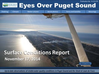
  • 1. November 17, 2014 Surface Conditions Report Eyes Over Puget Sound Fieldlog Climate Water column Aerial photos Ferry andSatellite Moorings Publication No. 14-03-079 Start here Up-to-date observations of visiblewater quality conditions in Puget Sound and the Strait of Juan de Fuca
  • 2. Personalfieldlog p.3 Meet our BEACH program. Climateconditions p.5 Arecent coldspell affects the Puget Soundlowlands, softening an8-monthtrendof warmer temperatures. The oceanremains warm. Watercolumn p.6 Puget Sound is a lot warmer at the end of 2014 with new max temps observedthroughout the Sound! Salinity and dissolved oxygenare mostly expected. The higher DO andcold temperature anomaly inHoodCanal is disappearing. Moorings p.40 Water temperature is coolingandthis accompanies reduced river flows of the past week. Aerialphotography p.10 Abundant patches of jellyfishseenin finger inlets of South Sound. Red-brownblooms remainstronginsmaller bays of SouthSoundcoincidingwith jellyfish. Suspended sediment increasingly visible as a result of increasedrain, wind, andwaves. Ferryand satellite p.35 Coldwater fromWhidbey Basinmoves into Puget Sound at the Triple Junction; associatedwithmoderate levels chlorophyll fluorescence. Increasedturbidity seenthroughout the Strait of Georgia. LONG-TERMMARINEMONITORINGUNIT Mya Keyzers Laura Hermanson Joe Leatherman Skip Albertson Dr. Christopher Krembs Guest: Dr. Brandon Sackmann, Integral Julia Bos Suzan Pool Editorial assistanceprovided by: Suzan Pool, CarolMaloy, Laura Hermanson Marine conditionsfrom 11-17-2014 at a glance Fieldlog Climate Water column Aerial photos Ferry andSatellite Moorings Please give us feedback
  • 3. The BEACHProgram helps to reduce the risk of disease for people who playin saltwater by: What is the Washington BEACH Program? Notifyingusers when bacteria results are high. Educatingthe public about risks associatedwithpollutionandwhat we cando to reduce the risks. Contactwith fecal bacteria contaminated waters can result in gastroenteritis, skin rashes, upper respiratory infections, and other illnesses. The Washington BEACH Programis led jointly by the Washington StateDepartment of Ecology and Department of Health. Our BEACH partners include county and local health jurisdictions, Tribes, and volunteers. Monitoringbacteria levels at popular, high risk beaches. The BEACH program 11-17-2014 Fieldlog Climate Water column Aerial photos Ferry andSatellite Moorings
  • 4. Keeping Washington beaches healthy -- we're all in this together! Stay updatedabout water quality at your beaches by keeping up withus on: Fecal Matters Blog: http://ecologywa.blogspot.com/search/label/Fecal%20matters Facebook:https://www.facebook.com/WABEACH Twitter: https://twitter.com/ecologywa Findpublic beaches and info onbeachclosures: https://fortress.wa.gov/ecy/coastalatlas/ Personal Field Impression Fieldlog Weather Water column Aerial photos Ferry andSatellite Moorings The BEACH program11-17-2014 Fieldlog Climate Water column Aerial photos Ferry andSatellite Moorings
  • 5. Fieldlog Climate Water column Aerial photos Ferry andSatellite Moorings Climateand natural influencesbefore 11-17-2014 Summary: Air temperatures continue an 8- month trend, though a recent cold period introduces cold dense air into the Puget Sound lowlands. Precipitation levels have been above normal, but nil during the past week as temperatures dropped. Cloud Cover has been near normal. River flows are beginning to climb above normal across the region. PDO remains in the warm phase, and upwelling is below normal. lowerhigher expected No data New section! Climate and natural influences are conditions that influence our marine waters, including weather, rivers, and the adjacent ocean (previously called Weather). For an explanation of the figure, see: http://www.ecy.wa.gov/programs/eap/mar_wat/weather.html, page 26.
  • 6. We usea chartered float plane to access our monthly monitoring stations. We communicate data and environmentalmarine conditions using: 1. MarineWater ConditionIndex (MWCI) 2. EyesOverPuget Sound (EOPS) 3. Anomaliesand sourcedata Fieldlog Weather Water column Aerial photos Ferry andSatellite Moorings Ourlong-termmarinemonitoringstationsinWashington Starthere Isl. .
  • 7. Physical conditionstracked in statistically historic context Fieldlog Weather Water column Aerial photos Ferry andSatellite Moorings Salinity lower at Coast Oxygen expectedOct. 2014: Temperature – New Max! PugetSound is a lot warmer at the end of 2014 with new max temps observed throughoutthe Sound! Early 2014 started colder and saltier with lower oxygen, then became fresher and warmer. Salinity is within expected ranges and dissolved oxygen arevariable throughoutthe regions. The higher DO anomaly in Hood Canal is disappearing. Redboxesshow thatthe water measuredin Octoberis warmer thanany of our measurements since 1999 Explore profiles atall stations
  • 8. a) PacificDecadalOscillationIndex(PDO,temperature) (explanation) b) UpwellingIndex(anomalies)(Upwelling,lowoxygen) (explanation) c) NorthPacificGyreOscillationIndex(NPGO,productivity) (explanation) NPGO(x10) PDO/UpwellingIndex Three-year running average of PDO, Upwelling, and NPGO indices scores Ocean boundaryconditions have been favorable for water qualityin Puget Sound: (a)colder water (PDO), (b)less upwelled lowoxygen and high nutrient ocean water reachingPuget Sound (UpwellingIndex),and (c) higher surface productivityalongthe coast (NPGO). Where are we headingnext? Fieldlog Weather Water column Aerial photos Ferry andSatellite Moorings . Theoceanaffectswaterquality: OceanClimateIndices -25 -20 -15 -10 -5 0 5 10 15 20 25 -1.5 -1 -0.5 0 0.5 1 1.5 1945 1950 1955 1960 1965 1970 1975 1980 1985 1990 1995 2000 2005 2010 2015
  • 9. Is the food web changing in Puget Sound? Follow the experts WebEx Hypothesis! Increasesin nitrate concentrations couldbe caused by a top-down controlon phytoplankton biomass. Noctiluca a visible harbingerof a food web change? Hypothesis for combining a series of recent observations affecting energy and material transfer to higher trophic levels Arechangesin highertropic levelspart of a story of the low food web?
  • 10. Summary: Aerial photography11-17-2014 Abundantpatches of jellyfish seen in finger inlets of South Sound. Red-brown blooms remain strong in smaller bays of South Sound and coincide with jellyfish. A localized bloom seen off Tokeland. Suspended sediment increasingly visible as a result of increased rain, wind, and waves. Fieldlog Weather Water column Aerial photos Ferry andSatellite Moorings Start here Mixing andFronts: Developed tidal fronts and mixing visible by colored surface water. Very pronounced in Grays Harbor. Debris: Organic debris and foamforming in patches near mudflats, river plumes, and tidal fronts as a resultof stronger winds and higher river flows. Visible blooms: Red-brown: Southern finger inlets of South Sound and very localized near Kindred Island, Willapa Bay. Jellyfish: Jellyfish patches very numerous in southern inlets of South Sound (Totten, Eld, and Budd Inlets). BloomDebrisFront Suspendedsediment: As a result of recent precipitation, many river influenced areas show largesediment plumes. Strong winds, tidal currents, and dredging affectsediment re-suspension regionally and locally. Plume Beautiful NiaviakumRiver, Willapa Bay Mudflats near SmithCreek, Willapa Bay 1 2 2019 5 7 8 9 10 12 4 5 6 8 9 10 13 14 15 17 1 2 12 17 2019 2 3 5 7 10 11 12 13 14 17 2018
  • 11. GraysHarbor Willapa Bay Fieldlog Climate Water column Aerial photos Ferry andSatellite Moorings Observation Maps: Afternoonflight,photos 13-20: Sunny,cold,winds increasing Flight Information: Morningflight,photos 1-12 Sunny,cold,high visibility 8 11 10 15 Aerial photography and navigation guide20 6 Coast SouthSound SeattleTides:H.tide:1:15AM12:58PM,,L.tide:6:29AM,8:00PM 7 12 5 Flight route and fuelingstop 17 9 18 3 2 1 4 13 14 19 16
  • 12. Numerous jellyfishsmacks with underlying red-brown bloom. Location: OffLittle Tykle Cove, Budd Inlet (South Sound),9:25 AM. 1 Aerial photography 11-17-2014 Navigate Fieldlog Climate Water column Aerial photos Ferry andSatellite Moorings Bloom jellyfish jellyfish jellyfish jellyfish jellyfish jellyfish jellyfish jellyfish jellyfish
  • 13. A. B. C. 2 NavigateAerial photography 11-17-2014 Fieldlog Climate Water column Aerial photos Ferry andSatellite Moorings Red-brown bloom, organic debris, jellyfishsmacks, and edge of river plume with internal waves. Location: A.FlapjackPoint,B. Shell Point,C. Snyder Cove, Eld Inlet (South Sound). Debris Bloom Bloom boat internal waves 9:27AM 9:27AM 1:31PM jellyfish jellyfish jellyfish Debris boat Bloom
  • 14. 3 NavigateAerial photography 11-17-2014 Long organic debris line in Chehalis River. Location: Cosmopolis (Grays Harbor),9:51AM. Fieldlog Climate Water column Aerial photos Ferry andSatellite Moorings Debris
  • 15. 4 Navigate Fieldlog Climate Water column Aerial photos Ferry andSatellite Moorings Aerial photography 11-17-2014 Sediment-richriver plume hugging the southern shoreline of Grays Harbor and Chehalis River water. Location: OffStafford Creek(Grays Harbor), 11:18 AM. Dredging barge sediment Plume Plume
  • 16. 5 NavigateAerial photography 11-17-2014 Fieldlog Climate Water column Aerial photos Ferry andSatellite Moorings Fronts where Chehalis River and local sediment-richriver waters meet marine water. Location: OffO’Leary Creek, south channel (Grays Harbor),9:55 AM. sedimentfromdredging Plume Plume Debris
  • 17. Suspended sediments from dredging. Location: Between North and South Channel,(Grays Harbor),9:56 AM. 6 NavigateAerial photography 11-17-2014 Fieldlog Climate Water column Aerial photos Ferry andSatellite Moorings sediment Dredging barge
  • 18. Front where Chehalis River water meets Grays Harbor water. Location: North Channel,offairport (Grays Harbor),11:33 AM. 7 NavigateAerial photography 11-17-2014 Fieldlog Climate Water column Aerial photos Ferry andSatellite Moorings Plume Debris
  • 19. Dark humic-rich water enteringbay and locally mixingwith sediment-richwater. Location: ArmstrongBay(Grays Harbor),10:28 AM. 8 NavigateAerial photography 11-17-2014 Fieldlog Climate Water column Aerial photos Ferry andSatellite Moorings sediment sediment Plume rescue helicopter
  • 20. Suspended sediment from wave, tidal currents, and water from Armstrong Bay mix around the point. Location: Damon Point (Grays Harbor),10:30 AM. 9 NavigateAerial photography 11-17-2014 Fieldlog Climate Water column Aerial photos Ferry andSatellite Moorings Plume mixing sediment
  • 21. 10 NavigateAerial photography 11-17-2014 Surface water of different origins (South and North Bay) meetingat the entrance to Grays Harbor. Location:Damon Point (Grays Harbor), 10:30 AM. Fieldlog Climate Water column Aerial photos Ferry andSatellite Moorings large ship mixing Debris
  • 22. 11 NavigateAerial photography 11-17-2014 Large patch of organic debris near tidally exposed sandbars at the entrance to Willapa Bay. Location: Entrance to WillapaBay(Willapa Bay),10:39PM. Fieldlog Climate Water column Aerial photos Ferry andSatellite Moorings Debris
  • 23. A. B. Red-brown bloom mixedwith local humic-rich, dark freshwater and organic debris along tide lines. Location: A.On the water,B. Above Tokeland (Willapa Bay),10:44 AM. 12 Navigate Fieldlog Climate Water column Aerial photos Ferry andSatellite Moorings Aerial photography 11-17-2014 Bloom Debris
  • 24. A. B. Suspended sediment and debris line along Naselle River plume blown by strong wind. Location: A.Long Island Slough,B. Chetlo Harbor, Naselle River (Willapa Bay),12:20 PM. 13 NavigateAerial photography 11-17-2014 Fieldlog Climate Water column Aerial photos Ferry andSatellite Moorings sediment Plume Plume Debris
  • 25. Water with increasing suspended sediment content towards Ocean Park as a result of southeasterly winds. Location: Nahcotta Channel(Willapa Bay),12:25 PM. 14 Navigate Fieldlog Climate Water column Aerial photos Ferry andSatellite Moorings Aerial photography 11-17-2014 Plume Debris
  • 26. 15 Navigate Fieldlog Climate Water column Aerial photos Ferry andSatellite Moorings Sediment-richwater meetingdark humic-rich water of the Espy Slough. Location: Off Port of Peninsula,Ocean Park(Willapa Bay),12:26 PM. Aerial photography 11-17-2014 Plume Plume
  • 27. 16 Navigate Exposedmudflats where Palix and Niawiakum rivers meet. Location: BayCenter (Willapa Bay),12:31 PM. Aerial photography 11-17-2014 Fieldlog Climate Water column Aerial photos Ferry andSatellite Moorings boat
  • 28. 17 Navigate Fieldlog Climate Water column Aerial photos Ferry andSatellite Moorings Red-brown bloom and water with suspended sediment meet at head of bay. Location: Oyster Bay,Totten Inlet (South Sound),1:25 PM. Aerial photography 11-17-2014 boat Debris Plume Bloom Plume
  • 29. 18 Navigate Fieldlog Climate Water column Aerial photos Ferry andSatellite Moorings Long organic debris line in tidally flooded head of bay. Location: Little Skookum Inlet,Eld Inlet (South Sound),1:26 PM. Aerial photography 11-17-2014 Debris
  • 30. 19 Navigate Fieldlog Climate Water column Aerial photos Ferry andSatellite Moorings Red-brown bloom being stirredby motorboat. Jellyfishand suspended sediment from shellfishoperations. Location: Off Deepwater Point,Totten Inlet (South Sound),1:25 PM. Aerial photography 11-17-2014 Bloom suspended sediment boatwake jellyfish jellyfish jellyfish boatboat boat
  • 31. 20 Navigate Large smacks of jellyfish,red-brown bloom, and turquoise water. Location: OffBaron Point,Totten Inlet (South Sound),1:29 PM. Aerial photography 11-17-2014 Fieldlog Climate Water column Aerial photos Ferry andSatellite Moorings jellyfish jellyfish jellyfish jellyfish boat Bloom Debris Bloom jellyfish
  • 32. Numbers on map refer to picture numbers for spatial reference Date: 11-17-2014 Coast Aerial photography observations in Central SoundObservations in Central and North Sound Navigate Fieldlog Climate Water column Aerial photos Ferry andSatellite Moorings 5 6 10 9 11 12 4 3 7 8 13 14 15 16
  • 33. Date: 11-17-2014 Observations in Hood Canal and South Sound Numbers on map refer to picture numbers for spatial reference Navigate Fieldlog Climate Water column Aerial photos Ferry andSatellite Moorings SouthSound 17 18 19 20 1 2
  • 34. Legendto map annotations Comments: Maps are producedby observers during and after flights. They are intendedto give an approximate reconstructionofthe surface conditions onscales that connect to and overlapwithsatellite images inthe sectionthat follows. Debris: Debris canbe distinguished into natural and anthropogenic debris floatingat the surface sensu Moore andAllen(2000). The majority of organic debris inPuget Sound is natural and mixedwithdiscardedman-made pieces of plastic, wood,etc. Fromthe plane, we cannot differentiatethe quality of debris at the surface andtherefore, call it for reasons of practicality just “debris”. S.L. Moore,M. J. Allen. 2000. Distribution of Anthropogenicand Natural Debris on the Mainland Shelf of the Southern California Bight. Marine Pollution Bulletin,40(1): 83–88. Navigate Fieldlog Climate Water column Aerial photos Ferry andSatellite Moorings
  • 35. Current Conditions: Cold water from WhidbeyBasin moves into Puget Sound at the Triple Junction;associated with moderate levels of chlorophyll fluorescence. Increased turbidityseen throughout the Strait of Georgia. Brandon Sackmann Contact: bsackmann@integral-corp.com Fieldlog Climate Water column Aerial photos Ferry andSatellite Moorings Ferry and satelliteobservations11-17-2014 Starthere 16 November 201416 November 2014
  • 36. Fieldlog Climate Water column Aerial photos Ferry andSatellite Moorings Ferry and satellite observations11-17-2014 A. Colder water in Whidbey Basin enters Main Basin near Triple Junction (Edmonds , B.); associated with moderatelevels of chlorophyllfluorescenceA. B. Coolsea surfacetemperatures (SST) throughoutPugetSound in November; falling below 11°C. C. Warmtemperatureanomaly detected in the Strait of Juan de Fuca during the last half of October. TheVictoria Clipper IV carries sensors in its sea chest. The sensors allow us to get surfacetransects of temperature, chlorophyll, salinity, and other bio-optical measurements between Seattle and Victoria, BC twice per day. B.A. C.
  • 37. Fieldlog Climate Water column Aerial photos Ferry andSatellite Moorings Ferry and satellite observations11-17-2014 16 November 2014 Data fromalternate route through Whidbey Basin in early November results in: A. lower salinity and B. high colored dissolved organic material (CDOM). Increased river flows since15 October are bringing in cold/fresh and highly colored water into Main Basin fromWhidbey Basin. Note inreferencetofigure above: A. B.
  • 38. Fieldlog Climate Water column Aerial photos Ferry andSatellite Moorings Ferry and satellite observations11-17-2014 Thermal Thermalimagery from Landsat8 shows warmer waters in South Puget Sound, LakeWashington, and Lake Sammamish. Cooler waters in Whidbey Basin and southern end of Hood Canal. True Color 11 November 2014
  • 39. Fieldlog Climate Water column Aerial photos Ferry andSatellite Moorings Ferry and satellite observations11-17-2014 MODIS-Aqua imagery from15 November show sedimenttransportoff the coast of Washington and turbid waters throughouttheStraitof Georgia. True Color Turbidity 11152014 ImageryobtainedfromNASA’s OceanColor WEB, http://oceancolor.gsfc.nasa.gov/
  • 40. Mooring observationsand trends 11-04-2014 to 11-17-2014 Fieldlog Climate Water column Aerial photos Ferry andSatellite Moorings AtMukilteo, water temperature is decreasing for the winter and this accompanies reduced river flows of the pastweek. In the upper mooring, water mixing appears reduced to tidal influences. The deeper mooring detected more than one water mass. During the past month, an early November shift from SW storms to cold and dry weather influenced variability in salinity (see next slide). 2-6 m depth Dissolvedoxygennot measured 12-16 m depth Theseplots show the probability of observations over the pasttwo-week period. High probability shown in warmcolors. Left Panels: Density is defined by salinity and temperature. Right Panel: Dissolved oxygen concentration in relation to salinity.
  • 41. Mooring observationsand trends 10-18-2014 to 11-17-2014 Click on icon to view real- time data of the moorings Fieldlog Climate Water column Aerial photos Ferry andSatellite Moorings Our mooring station in Mukilteo is located in Whidbey Basin near Everett. It is also located at the transition between Possession and Central Sounds at a depth that is influenced by the Skagitand Snohomish river discharges, prevailing winds, and tidal mixing. As the largestregional contributor of freshwater to PugetSound, understanding the timing and magnitude of the Skagit river flow is important. We presentdata of daily means for the past 31 days. Data areplotted in Pacific Standard Time. Wind data arefrom Paine Field in Everett. River flow data arefrom USGS.
  • 42. Mooring observationsand trends Mukilteo2010 to 2014 Fieldlog Climate Water column Aerial photos Ferry andSatellite Moorings Atthe Mukilteo mooring, weuse the near-bottom sensor (12-16 mdeep) to measuresignificant inter- annualvariability in temperature, salinity, and dissolved oxygen. This is typically near the pycnocline and the water with a high residence time in Whidbey Basin. Inter-annualvariability is shown over a 5-year period. All three variables show strong seasonality. SinceAugust, water temperature has been warmer than pastyears. In October and November, salinity is similar to or lower than pastyears and dissolved oxygen is higher than or similar to pastyears. September 2014 data for salinity and oxygen are invalid after we found the sensor sitting on sediment; data wereremoved. A sensor performanceverification indicated the dissolved oxygen sensor failed in early July and thus, dissolved oxygen data for July 2014 are fromlatter half of the month. Pleasenote that data are provisional. Data are in GMT.
  • 43. Accessmooring data: ftp://www.ecy.wa.gov/ea p/Mooring_Raw/Puget_S ound/ Ferryand satellite : Suzan.Pool@ecy.wa.gov Get data from Ecology’sMarine MonitoringPrograms Long–Term MonitoringNetwork Real–Time SensorNetwork Accesscore monitoringdata: http://www.ecy.wa.gov/a pps/eap/marinewq/mwda taset.asp christopher.krembs@ecy.w a.gov Ecology’s long-termmarine monitoring stations Ferrytrack Fieldlog Climate Water column Aerial photos Ferry andSatellite Moorings Riverand Stream WaterQuality Monitoring http://www.ecy.wa.gov/programs/eap/fw_riv /rv_main.html Discontinued (fundingcuts)
  • 44. You maysubscribe or unsubscribe to the Eyes Over Puget Sound email listservby going to: http://listserv.wa.gov/cgi-bin/wa?A0=ECOLOGY-EYES-OVER-PUGET-SOUND Many thanks to our business partners: Clipper Navigations, SwantownMarina,andKenmore Air. We are looking forfeedbackto improve ourproducts. Dr. ChristopherKrembs christopher.krembs@ecy.wa.gov Marine Monitoring Unit EnvironmentalAssessment Program WA Department of Ecology Fieldlog Climate Water column Aerial photos Ferry andSatellite Moorings