
Recommended
More Related Content
Similar to EOPS_2019_01_10.pdf
Similar to EOPS_2019_01_10.pdf (20)
More from EOPS EOPS
More from EOPS EOPS (15)
Recently uploaded
Recently uploaded (20)
EOPS_2019_01_10.pdf
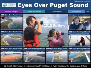
- 1. Eyes Over Puget Sound Up-to-date observations of visible water quality conditions in Puget Sound and the Strait of Juan de Fuca 2018 Review Food for thought Climate and streams Fish and food Aerial photos Info Publication No. 19-03-070 Sharing views of your own backyard Dr. Christopher Krembs 7 years behind the camera
- 2. The 2017 Puget Sound Marine Waters Report Download here: http://www.psp.wa.gov/PSmarinewatersoverview.php
- 3. EOPS observations provide food for thought Food for thought Climate and streams Fish and food Aerial photos Info Could the future of climate change offer more opportunities than we tend to think? In 2018, water temperatures were slightly warmer than normal, and aerial photos revealed an abundance of spawning herring and baitfish. We saw abundant macroalgae across Puget Sound and a two-month-long Noctiluca bloom in Central Sound. Countless blooms occurred in bays of South Sound, the Kitsap Peninsula, Sequim, and Bellingham Bay. Despite many visible eutrophication indicators, bait fish appeared to be abundant.
- 4. What influences Puget Sound water quality? higher No data lower expected *Upwelling/downwelling Anomalies PDO = Pacific Decadal Oscillation ENSO = El Niño Southern Oscillation Climate conditions for 2018 were marked by a cool and wet spring followed by a warm, dry, and sunny summer with lower river flows. The onset of a dry summer spell started in May, one month earlier than in 2017. In the fall, conditions were sunnier and drier than the previous year, which also led to lower river flows through October 2018. Conditions Jan 2017 to Dec 2018: Air temperatures were generally slightly above normal since April 2018, repeating the pattern of 2017. Precipitation was lower in summer of 2018 and similar to 2017. Fall rain in 2018 was low. Sunshine, the opposite of cloud cover, was higher in the fall of 2018, also leading to drier conditions. River flows were noticeably lower in the summer of 2018 than in 2017. Upwelling and ENSO have been positive. All data are from public sources: UW GRAYSKIES; river flows from USGS and Environment Canada; indices from NOAA & UW (PDO). Data not available due to federal government shutdown Food for thought Climate and streams Fish and food Aerial photos Info
- 5. Near-normal temperatures for both states (compared to 1981-2010) WA: +0.8°F anomaly OR: +0.9°F anomaly Washington was not as dry as Oregon in 2018 Oregon was very dry in 2018 Average weather conditions for the year 2018 Differences in precipitation between WA and OR WA: +1.90” anomaly OR: 16th driest Water Year (since 1895) Courtesy of Karin Bumbaco and Nick Bond Office of the Washington State Climatologist Joint Institute for the Study of Atmosphere and Ocean University of Washington November, 2018 Washington State compared to Oregon State in 2018 Paired temperature and precipitation data for Washington and Oregon Food for thought Climate and streams Fish and food Aerial photos Info
- 6. Climateinfluences:HowwellisPugetSoundexchangingits water? The Fraser River is the major driver of estuarine circulation and water exchange between the Salish Sea and the ocean. Climate forecasts predict earlier snowmelt and earlier delivery of water to the Salish Sea. This affects how well water renews and exchanges with ocean water. Do we see four years of climate impact since 2015? NPGO (x10) PDO/Upwelling Index Large scale boundary conditions are currently relatively neutral. Past years’ warm water is gone (PDO) and upwelling is more likely (Upwelling Index anomaly). Unfortunately, reporting of the NPGO, which reflects the surface productivity along the coast, has been temporarily discontinued. Pacific Decadal Oscillation Index (PDO, temperature, explanation). Upwelling Index (anomalies) (Upwelling, low oxygen, explanation). North Pacific Gyre Oscillation Index (NPGO, productivity, explanation). Three-year running average of PDO, Upwelling, and NPGO Indices -25 -15 -5 5 15 25 -1.5 -1 -0.5 0 0.5 1 1.5 1945 1950 1955 1960 1965 1970 1975 1980 1985 1990 1995 2000 2005 2010 2015 Historically, the peaks of coastal upwelling and the freshet are in sync. Climate shifts the relative timing of both processes. 1. 2. 3. 4. Food for thought Climate and streams Fish and food Aerial photos Info Upwelling Index (2-week-avg) Fraser River discharge (m 3 s -1 ) higher, lower than normal and, expected flows coastal upwelling
- 7. South Sound (black line = baseline 1999 – 2018) generally offers prolonged periods near the herring growth optimum. In winter, Hood Canal generally offers the warmest overwintering temperatures (8 – 9 °C water kills anchovies). This year, surface water temperatures (0 – 30 m) were consistently above normal (red dots). Phytoplankton supporting the food chain were consistently higher (green) than normal (dashed line) in adjacent basins of Puget Sound and north. (Chlorophyll a is used as a proxy for phytoplankton biomass). Temperature and food can affect fish growth Herring growth optimum temp. Food for thought Climate and streams Fish and food Aerial photos Info phytoplankton above normal 2018 below normal 2018 normal 1999-2017 anchovy Minimal survival temperature herring Herring growth optimum temperature water temperature above normal below normal normal South Sound Central Sound North Sound Whidbey Basin Hood Canal Strait of Juan de Fuca Anchovy survival temp. Chlorophyll a conc. (µg/l) Chlorophyll a conc. (µg/l) Temperature (°C) Temperature (°C)
- 8. Instantaneous herring larval growth rates (Gi/d) 0 0.05 0.1 0.15 0.2 0.25 0.3 Color legend Fish need optimal water temperatures (red) and food to grow. Assuming that phytoplankton biomass is a reflection of the amount of zooplankton that fish eat, South Sound and Hood Canal in 2018 stand out for having had prolonged good growth conditions for juvenile fish in terms of both food and water temperatures. Whidbey Basin provided high but inconsistent phytoplankton biomass in summer, and water temperatures took longer to reach optimal growth conditions. Paulsen et al. Helgol Mar Res (2016) 70:17DOI 10.1186/s10152-016-0470-y =Month Optimal growth Temperature and food can affect herring growth region of optimal herring growth Food for thought Climate and streams Fish and food Aerial photos Info South Sound Central Sound North Sound Whidbey Basin Hood Canal Strait of Juan de Fuca 0.0 0.1 0.1 0.2 0.2 7 9 11 13 15 17 19 Instantanious growth Gi Temperature (°C) Herring larvae
- 9. Jan. – Feb. Mar. Apr. May Jun. Jul. Sep. Nov. Oil sheens on the water remained a recurring sight in Salmon Bay. Milky water caused by spawning herring occurred more abundantly than usual. Some red-brown blooms appeared very early this year in Sinclair Inlet. We documented brown blooms that we have not seen before near Padilla Bay. Strong blooms developed with lots of organic material drifting at the surface. Unusually numerous schools of baitfish were seen from the air at many shallow terminal bays. A strong Noctiluca bloom extended across southern portions of Central Puget Sound and a large coccolithophore bloom in Hood Canal. Large rafts of macroalgae developed on beaches and started to drift across Puget Sound. Macroalgae were extremely abundant on the water especially in South and Central Sound. An intense red bloom engulfed Bellingham Bay and adjacent regions. Many smaller bays showed red or yellow-green blooms. Number of red blooms had intensified in bays of the Kitsap Peninsula, Marrowstone Island, and Sequim Bay. Jelly fish patches became distinctly visible from the air in terminal inlets of smaller bays. Large schools of baitfish and jellyfish were still present in South Sound, as were red-brown algal blooms. In 2018, water temperatures were still slightly above normal, and aerial photos revealed an abundance of spawning herring and baitfish. We saw abundant macroalgae across Puget Sound and a two-month long Noctiluca bloom in Central Sound. Countless blooms occurred in bays of South Sound, the Kitsap Peninsula, Sequim and Bellingham Bay. We reported incidents of failing effluent diffusers (Port Townsend) and oil sheens in waterways of Seattle (Salmon Bay). 2018 Year in Review: Aerial photography The year 2018 stood out as a biologically highly productive year. Christopher Krembs Start here Food for thought Climate and streams Fish and food Aerial photos Info
- 10. Strait of Juan de Fuca San Juan Islands Padilla Bay Main Basin Hood Canal South Sound Whidbey Basin 1 4 2 3 8 9 13 14 11 7 6 Aerial photography & navigation guide 30 17 16 15 19 18 20 21 22 24 23 25 26 27 28 29 The map is a navigation guide to quickly find areal pictures in a region. The numbers depict locations in chronological order of when they were taken in 2018. Food for thought Climate and streams Fish and food Aerial photos Info 5 12 10
- 11. Repeated oil sheen on water near Seattle Fire Station, Dock 3. Location: Salmon Bay, Seattle (Central Sound), 2:25 PM oil sheen oil sheen 1 Navigate Aerial photography 2-13-2018 Food for thought Climate and streams Fish and food Aerial photos Info
- 12. White cloudy water stretching from Point Partridge past Perego’s Lagoon. Spawning herring? Location: Admiralty Reach (North Sound), 1:52 PM 2 Aerial photography 3-16-2018 Perego’s Lagoon Perego’s Lagoon Looking north Looking south spawn spawn spawn spawn Navigate Food for thought Climate and streams Fish and food Aerial photos Info
- 13. A. B. A. Bright brown water leaving Joe Leary Slough. B. Is this a brown bloom following the tidal channel? Location: Padilla Bay (North Sound), 12:54 PM 3 Aerial photography 4-19-2018 Joe Leary Slough Navigate Food for thought Climate and streams Fish and food Aerial photos Info
- 14. Bright red-brown-purple bloom with an occasional jellyfish patch. Location: Sinclair Inlet (Central Sound), 1:49 PM 4 Aerial photography 4-19-2018 jellyfish boat Bloom Navigate Food for thought Climate and streams Fish and food Aerial photos Info
- 15. A. Noctiluca bloom surfacing near Priest Point Park, low altitude. B. At higher altitude. Location: Budd Inlet (South Sound), 12:12 PM Priest Point A. B. 5 Aerial photography 5-22-2018 Priest Point Bloom Debris Bloom Debris Navigate Food for thought Climate and streams Fish and food Aerial photos Info
- 16. Many patches of schooling fish. Location: A. Near Allen Point. B. Near Purdy Sand Spit (South Sound), 12:00 PM Purdy Sand Spit Allen Point A. B. 6 Aerial photography 5-22-2018 fish fish fish fish fish fish fish fish fish fish fish fish Navigate Food for thought Climate and streams Fish and food Aerial photos Info
- 17. A. Large ribbons of organic material, likely Noctiluca. B. Algal bloom extending north. Location: Saratoga Passage (Whidbey Basin), 1:44 PM A. B. 7 Aerial photography 5-22-2018 East Point Camano Island Bloom Debris Front Navigate Food for thought Climate and streams Fish and food Aerial photos Info
- 18. A & B. Strong algal bloom and tidal fronts in Main Basin contrasted against Colvos Passage blue water. Location: Blake Island (Central Basin), 2:40 PM A. B. 8 Aerial photography 5-22-2018 Blake Island Blake Island Bloom Front Bloom ferry ferry Navigate Food for thought Climate and streams Fish and food Aerial photos Info
- 19. Noctiluca bloom surfacing and accumulating along tidal fronts. Location: North of Commencement Bay (Central Sound), 10:16 AM 9 Aerial photography 6-5-2018 Dash Point Debris Front Navigate Food for thought Climate and streams Fish and food Aerial photos Info
- 20. Duckabush River delta at very low tide exposing macroalgae. Turquoise coccolithophore bloom Location: Duckabush River (Hood Canal), 12:18 PM Bloom macroalgae Aerial photography 6-28-2018 10 Navigate Food for thought Climate and streams Fish and food Aerial photos Info
- 21. Large ribbons of Noctiluca and macroalgae accumulating at the surface. Location: Poverty Bay (Central Sound), 1:34 PM 11 Aerial photography 6-28-2018 Poverty Bay Debris Debris Navigate Food for thought Climate and streams Fish and food Aerial photos Info
- 22. A. Mudflats during ebb tide and (B.) low tide. C. Temperatures vary considerably across the estuary. Location: Nisqually River Delta (South Sound), 3:28 PM Nisqually R. 16.5 °C 18.1 °C A. B. C. Aerial photography 7-16-2018 12:58 PM 3:28 PM McAllister C. McAllister C. 12 Navigate Food for thought Climate and streams Fish and food Aerial photos Info
- 23. A. Large mats of macroalgae accumulating at front, red-brown bloom, and schools of fish. B. From altitude. Location: Budd Inlet (South Sound), 12:36 PM fish A. B. Aerial photography 7-16-2018 Gull Harbor Big Tykle Cove fish fish fish boat macroalgae macroalgae Bloom 13 Navigate Food for thought Climate and streams Fish and food Aerial photos Info
- 24. Large mats of macroalgae accumulating off beaches in southwestern portions of Carr Inlet. Location: Carr Inlet (South Sound), 1:03 PM Aerial photography 7-16-2018 macroalgae boat Bloom 14 Navigate Food for thought Climate and streams Fish and food Aerial photos Info
- 25. Red-brown bloom extending in long ribbons from Samish Bay into Padilla Bay. Location: Samish Island (North Sound), 2:01 PM 15 Aerial photography 7-16-2018 17.0 °C 16.1 °C Samish Island ship Bloom Navigate Food for thought Climate and streams Fish and food Aerial photos Info
- 26. Large and very patchy red-brown bloom. Location: Samish Island (North Sound), 2:03 PM 16 Aerial photography 7-16-2018 ship Samish R. Bloom DOH Expert Jerry Borchert: Bloom consisting of Gonyaulax digitale and Scrippsiella trochoidea Navigate Food for thought Climate and streams Fish and food Aerial photos Info
- 27. Red-brown bloom of two colors entering Bellingham Bay via Hale Passage. Location: Lummi Island (North Sound), 2:14 PM 17 Aerial photography 7-16-2018 15.5 °C 16.2 °C Portage Island Lummi Island boat Bloom Navigate Food for thought Climate and streams Fish and food Aerial photos Info
- 28. Red-brown and yellow-green blooms in Barlow Bay. Location: Mackaye Harbor, Lopez Island (North Sound), 2:28 PM 18 Aerial photography 7-16-2018 Lopez Island Bloom Navigate Food for thought Climate and streams Fish and food Aerial photos Info
- 29. Large mats of macroalgae accumulating along tidal fronts. Location: Port Madison (Central Sound), 2:56 PM 19 Aerial photography 7-16-2018 Bainbridge Island Suquamish boat Bloom macroalgae Navigate Food for thought Climate and streams Fish and food Aerial photos Info
- 30. Large mats of macroalgae accumulating along edges of Puyallup River plume. Location: Commencement Bay (Central Sound), 3:12 PM 20 Aerial photography 7-16-2018 Vashon Island boat boat macroalgae Plume Navigate Food for thought Climate and streams Fish and food Aerial photos Info
- 31. Red-brown bloom in southern portions of Nisqually Reach. Location: Nisqually Reach (South Sound), 3:29 PM Bloom 21 Aerial photography 7-16-2018 Anderson Island boat Navigate Food for thought Climate and streams Fish and food Aerial photos Info
- 32. A. Likely jellyfish, but not confirmed. B. Large red-brown bloom near Port Orchard. Location: Sinclair Inlet (Central Sound), 12:48 PM jellyfish Gorst Bloom A. B. Port Orchard boat Aerial photography 9-17-2018 boat 22 Navigate Food for thought Climate and streams Fish and food Aerial photos Info
- 33. Red-brown bloom and organic surface debris in various places in Dyes Inlet. Location: Dyes Inlet (Central Sound), 12:50 PM Aerial photography 9-17-2018 Oyster Bay Bloom Silverdale Bloom Tracyton Rocky Point Front Bloom Debris 23 Navigate Food for thought Climate and streams Fish and food Aerial photos Info
- 34. B. A. Red-brown bloom with white milky patch, likely jellyfish. B. Bloom extending north into Kilisut Harbor. Location: A. Scow Bay. B. Marrowstone Island (North Sound), 1:15 PM A. Indian Island Bloom Bloom Aerial photography 9-17-2018 Marrowstone Island jellyfish 24 Navigate Food for thought Climate and streams Fish and food Aerial photos Info
- 35. Aerial photography 9-17-2018 Water with surfacing turbidity, likely from an underwater diffuser. Location: Port Townsend Bay (North Sound), 1:25 PM outfall barge Glen Cove Indian Island Port Townsend State Park 25 Navigate Food for thought Climate and streams Fish and food Aerial photos Info
- 36. Vivid red-brown bloom covering large portions of Sequim Bay north to Pitship Point. Location: Sequim Bay (Strait of Juan de Fuca), 1:26 PM Aerial photography 9-17-2018 Pitship Point Bloom boat 26 Navigate Food for thought Climate and streams Fish and food Aerial photos Info
- 37. Red-brown bloom and river plume revealing interesting flow pattern in surface water. Location: Quartermaster Harbor (Central Sound), 2:48 PM 27 Aerial photography 9-17-2018 Bloom Hand Portage Plume Bloom Navigate Food for thought Climate and streams Fish and food Aerial photos Info
- 38. Internal waves traveling through a red-brown bloom reveal that the bloom is at the water surface. Location: Budd Inlet (South Sound), 3:08 PM 28 Aerial photography 9-17-2018 cloud reflections boat Bloom boat internal waves Navigate Food for thought Climate and streams Fish and food Aerial photos Info
- 39. Numerous schools of fish. Location: Totten Inlet (South Sound), 12:41 PM Aerial photography 11-6-2018 Windy Point fish fish fish fish fish fish 29 Navigate Food for thought Climate and streams Fish and food Aerial photos Info
- 40. Long ribbons of jellyfish stretched along the direction of tidal flow. Location: Budd Inlet (South Sound), 1:00 PM 30 Aerial photography 11-6-2018 jellyfish jellyfish jellyfish jellyfish Navigate Food for thought Climate and streams Fish and food Aerial photos Info
- 41. Find past editions of EOPS on the next pages We have published 79 editions! Recommended Citation (example, September 2018): Washington State Department of Ecology. 2018. Eyes Over Puget Sound: Surface Conditions Report, September 17, 2018. Ecology Publication No. 18-03-075. https://fortress.wa.gov/ecy/publications/documents/1803075.pdf. Find all previous Eyes Over Puget Sound editions at the end of this document. Contact: Dr. Christopher Krembs Christopher.Krembs@ecy.wa.gov Marine Monitoring Unit Environmental Assessment Program Washington State Department of Ecology Subscribe to the Eyes Over Puget Sound email listserv. Many thanks to our business partners: Shannon Point Marine Lab (WWU), Swantown Marina, and Kenmore Air. Food for thought Climate and streams Fish and food Aerial photos Info
- 42. Month_date_year, Publication No. 20-03-07X Month_date_year, Publication No. 20-03-07X Month_date_year, Publication No. 20-03-07X Month_date_year, Publication No. 20-03-07X March_16_2020, Publication No. 20-03-071 Jan_10_2020, Publication No. 20-03-070 October_30_2019, Publication No. 19-03-076 September_12_2019, Publication No. 19-03-075 July_29_2019 Publication No. 19-03-074 June_4_2019, Publication No. 19-03-073 March_26_2019, Publication No. 19-03-072 February_21_2019, Publication No. 19-03-071 January_10_2019, Publication No. 19-03-070 November_6_2018, Publication No. 18-03-075 September_17_2018, Publication No. 18-03-074 July_16_2018, Publication No. 18-03-073 June_28_2018, Publication No. 18-03-072 May_22_2018, Publication No. 18-03-025 April_19_2018, Publication No. 18-03-071 Winter_2018, Publication No. 18-03-070
- 43. October_31_2017, Publication No. 17-03-073 August_28_2017, Publication No. 17-03-072 July_24_2017, Publication No. 17-03-071 June_6_2017, Publication No. 17-03-070 December_31_2016, Publication No. 16-03-079 November_22_2016, Publication No. 16-03-078 September_26_2016, Publication No. 16-03-077 August_24_2016, Publication No. 16-03-076 July_20_2016, Publication No. 16-03-075 June_27_2016, Publication No. 16-03-074 May_2_2016, Publication No. 16-03-073 April_6_2016, Publication No. 16-03-072 March_16_2016, Publication No. 16-03-071 February_8_2016, Publication No. 16-03-070 December_30_2015, Publication No. 15-03-080 December_14_2015, Publication No. 15-03-079 October_6_2015, Publication No. 15-03-078 September_21_2015, Publication No. 15-03-077 August_8_2015, Publication No. 15-03-076 July_6_2015, Publication No. 15-03-075
- 44. June_8_2015, Publication No. 15-03-074 April_29_2015, Publication No. 15-03-073 March_24_2015, Publication No. 15-03-072 February_17_2015, Publication No. 15-03-071 January_28_2015, Publication No. 15-03-070 December_30_2014, Publication No. 14-03-080 November_17_2014, Publication No. 14-03-079 October_29_2014, Publication No. 14-03-078 September_16_2014, Publication No. 14-03-077 August_18_2014, Publication No. 14-03-076 July_28_2014, Publication No. 14-03-075 June_23_2014, Publication No. 14-03-074 May_12_2014, Publication No. 14-03-073 April_21_2014, Publication No. 14-03-072 March_24_2014, Publication No. 14-03-071 February_4_2014, Publication No. 14-03-070 December_31_2013, Publication No. 13-03-081 November_21_2013, Publication No. 13-03-080 October_28_2013, Publication No. 13-03-079 September_11_2013, Publication No. 13-03-078
- 45. August_21_2013, Publication No. 13-03-077 July_15_2013, Publication No. 13-03-076 June_17_2013, Publication No. 13-03-075 May_20_2013, Publication No. 13-03-074 April_8_2013, Publication No. 13-03-073 Mar_25_2013, Publication No. 13-03-072 February_26_2013, Publication No. 13-03-071 January_15_2013, Publication No. 13-03-070 December_13_2012, Publication No. 12-03-081 November_8_2012, Publication No. 12-03-080 October_8_2012, Publication No. 12-03-079 September_11_2012, Publication No. 12-03-078 August_27_2012, Publication No. 12-03-077 July_31_2012, Publication No. 12-03-076 June_12_2012, Publication No. 12-03-075 May_14_2012, Publication No. 12-03-074 April_23_2012, Publication No. 12-03-073 March_19_2012, Publication No. 12-03-072 February_27_2012, Publication No. 12-03-071 January_30_2012, Publication No. 12-03-070
- 46. December_5_2011, Publication No. 11-03-082 November_15_2011, Publication No. 11-03-081 October_17_2011, Publication No. 11-03-080 September_12_2011, Publication No. 11-03-079 August_8_2011, Publication No. 11-03-078 July_6_2011, Publication No. 11-03-077 June_20_2011, Publication No. 11-03-076 June_6_2011, Publication No. 11-03-075 May_4_2011, Publication No. 11-03-074 April_27_2011, Publication No. 11-03-073