Human impacts on pristine environment in the knuckles mountain forest range (1)
•
0 likes•84 views

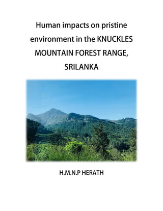
The Knuckles Mountain Range lies in central Sri Lanka, in the Districts of Matale and Kandy. The range takes its name from a series of recumbent folds and peaks in the west of the massif which resemble the knuckles of clenched fist when viewed from certain locations in the Kandy District.

Recommended
More Related Content
What's hot
What's hot (20)
Similar to Human impacts on pristine environment in the knuckles mountain forest range (1)
Similar to Human impacts on pristine environment in the knuckles mountain forest range (1) (20)
More from Nimashi Herath
Recently uploaded
Recently uploaded (20)
Human impacts on pristine environment in the knuckles mountain forest range (1)
- 2. About the Knuckles Mountain Range.... The Knuckles Mountain Range lies in central Sri Lanka, in the Districts of Matale and Kandy. The range takes its name from a series of recumbent folds and peaks in the west of the massif which resemble the knuckles of clenched fist when viewed from certain locations in the Kandy District. Figure 1- Location of the conservation forest The higher mountain area is often robed in thick layers of cloud. In addition to its aesthetic value, the range is of great scientific interest. It is a climatic microcosm of the rest of Sri Lanka as the conditions of all the climatic zones in the country are exhibited in the massif. At higher elevations there is a series of isolated cloud forests, harboring a variety of flora and fauna. Although the range constitutes approximately 0.03% of the island’s total area, it is home to a significantly higher proportion of the country’s biodiversity. The isolated Knuckles range harbors several relict, endemic flora and fauna that are distinct from central massif. More than 34 percent of Sri Lanka's endemic trees, shrubs, and herbs fish species , birds and animals are only found in these forests. Aside from holding a rich biodiversity, the Knuckles forest delivers a number of important ecosystem services — it constitutes 30% of the watershed forest of the Mahaweli river catchment, the largest river in Sri Lanka and is a major source of water for agriculture and power generation. Several tributaries of the Mahaweli river originate from the Knuckles forest, with the area serving as part of the upper and middle
- 3. catchments of the river. The forest also plays a crucial role in regulating water quality and flow rate. Figure 2-the board describing the fish diversity Human impact Knuckles mountain forest range (KMFR) in Sri Lanka that has been designated as a world heritage site for its high level of biodiversity is heavily disturbed and fragmented due to various human activities mainly tea and cardamom plantation
- 4. Figure 3- Tea plantation in knuckles Figure 4- Pinus plantation in knuckles The bird species richness, abundance and similarity of bird species composition were investigated in three prominent agricultural land-uses i.e. Pinus, cardamom and abandoned tea plantations, and in an undisturbed sub-Montana forest in Northern Flank of KMFR. The Pinus and abandoned tea plantations supported a fewer number of bird species than undisturbed forest. But the cardamom plantation with diverse, native shade trees, had a bird species richness comparable to undisturbed forest The other human activity that the biodiversity is heavily disturbed is the MORAGAHAKANDA agricultural development project. Six major vegetation types present in KMFR have been affected by this project; tropical dry mixed evergreen forests, tropical moist evergreen forests, riverine forests, tropical thorn forests, dry patina grassland (savannah) and agricultural lands. A total of 456 plant species belonging to 93 families have been recorded in the project area. Among them were 29 endemic species.14 nationally threatened species and 247 medicinal plant species. vertebrate fauna totaling 272 species belonging to 84 families have been recorded in various habitat and vegetation types in the project area. There were 47 endemic and 42 nationally threatened species among them. The major threats to the biodiversity of the MORAGAHAKANDA project area have been identified as habitat degradation, deterioration, modification, direct exploitation of flora and fauna and spread of invasive species. At present only a few invasive alien species occur in the project area.
- 5. However, during the construction stage earth moving machinery as well as construction material such as soil and gravel that are brought into the site can introduce seeds of invasive alien species into the area. Further, the areas cleared of vegetation to extract borrow material as well as construction material storage areas are also potential sites for establishment of alien invasive species. Therefore, during the construction stage there is a strong possibility of introduction and establishment of invasive plant species into the project area which can subsequently spread into surrounding areas. As much of the work takes place in protected areas, special attention needs to be taken to prevent the introduction of alien invasive species. Impacts due to labour force for construction activities will lead to establishment of campsites, generation of sewage, waste water and solid waste. Further, they may engage in activities that are detrimental to natural habitats such as hunting, and illegal extraction of timber and non timber forest products. 203 Noise and vibrations that will arise due to activities such as excavation, cutting, drilling and filling and compaction work, as well as operation of construction related vehicles during the construction phase will cause disturbance especially to the fauna that inhabits the project area. Clearance of plant cover during the construction phase will lead to increased soil erosion, which in turn will result in increased sedimentation of natural waterways in the cleared areas. Further, access road creation, land preparation will result in blockage or alteration of natural flow paths in the area resulting changes in the drainage patterns in the area. Figure 5- MORAGAHAKANDA agricultural development project
- 6. Figure 6 & 7-dam construction work KALUGANGA reservoir and agricultural extension project area also falls within the dry zone bio region and the intermediate zone bioregion in knuckles. The area contain mosaic of habitats that support rich floral diversity and faunal assemblages. Among them the kalu ganga basin area had a greater natural habitat diversity of all the habitats the river and the riverine habitat supported the richest species assemblage followed by tanks disturbed forests and scrublands. The natural ground spring and forest are the unique habitats present within the human resettlement area. A total of 401 plant species including 33 endemic and 17 nationally threatened species identified. Also 307 faunal species will be threatened which representing butterflies, dragonflies, fishes, amphibians, reptiles, birds and mammals. Among them 38 species are endemic to Srilanka. Biodiversity loss fragmentation and degradation of habitats due to the establishment of the two reservoirs are the largest impact with increased human elephant conflict being the second and other associated developments such as resettlement areas roads etc. Positive impact on certain species of freshwater fish, such as Wallagoattu (shark fish), and Systomusrichmondi by providing habitats. Disruption of the movement patterns of wide ranging species such as elephants and ungulates. Loss of habitat in the inundation area for stream dwelling fish especially those species that are endemic threatened and restricted to this region (eg- Dawkinsiasrilankensis , Systomusrichmondi, Devarioaequipinnatus). Also loss of unique habitats and migratoty paths as well as the loss of threatened and endemic species.
- 7. Figure 8 & 9-this river is situated in a lower place of the mountain where human impact is high and fish diversity is low Figure 10,11 & 12-when the MORAGAHAKANDA reservoir is filled with water this place disappears in water and habitat destruction occurs while diversity is harmed as a result
- 8. The other human activities that the biodiversity is disturbed are picnics , hiking, other human events where humans discard garbage which are non bio degradable to the environment. Figure 13- boards have been placed advising people not to harm the environment Activities implemented to minimize the impacts on the environment 1. Reforestation of Amban Ganga Basin catchment area 2. Demarcating a 100m buffer zone around Moragahakanda reservoir and reforestation of 650ha inside this buffer zone 3. Establishment an elephant corridor between Giritale- Minneriya nature reserve and wasgamuwa national park. Habitat enrichment is carried out in these areas. 4. Rehabilitation of tanks in adjacent natural areas. 5. Eradicating wildlife in the water spread areas. 6. Relocation of wildlife in the water spread areas 7. Establishment of an electric fence around the resettlement area to reduce human elephant interactions.
- 9. 8. Boards are placed which advice humans not to harm the environment with their actions 9. Conduction of awareness programs targeting communities